การวิเคราะห์แบบจำลองเวกเตอร์ (vector model)
TRANSCRIPT

การวเิคราะห์แบบจ าลองเวกเตอร์ (Vector Model)
เปิด->ArcMap10.1
เปิด->dam ->Table of contents

คลกิGeoprocessing->Buffer
จะได้หน้าตา่ง ดงันี ้

ช่อง Input Features ->dam ชอ่งoutput Features Class->เลอืกที่ต้องการจะSave เปลีย่นชอ่งLinear unit->500
กดSave ช่ือ Dam500

กด ->Close
เปิด->Dam500 ->Table of contents

เปิดข้อมลู ->a5239iii , a5238iv , a5238iii , a5238i ->Table of contents
คลกิGeoprocessing->Merge

ช่องInput Datasets เลอืก a5239iii , a5238iv , a5238iii , a5238i
ช่อง Output Dataset กด Save -> Admin แล้วกด Save

กด Close
เปิดข้อมลู Admin ที่ Table of contents

คลกิ Remove -> a5239iii , a5238iv , a5238iii , a5238i
คลกิ Remove -> dam

คลกิ Admin-> Open Attribute Table

เปิด Catalog ->เลอืก luamp , lutam และluprv ->ไปท่ี Table of contents
คลกิ lutam-> Open
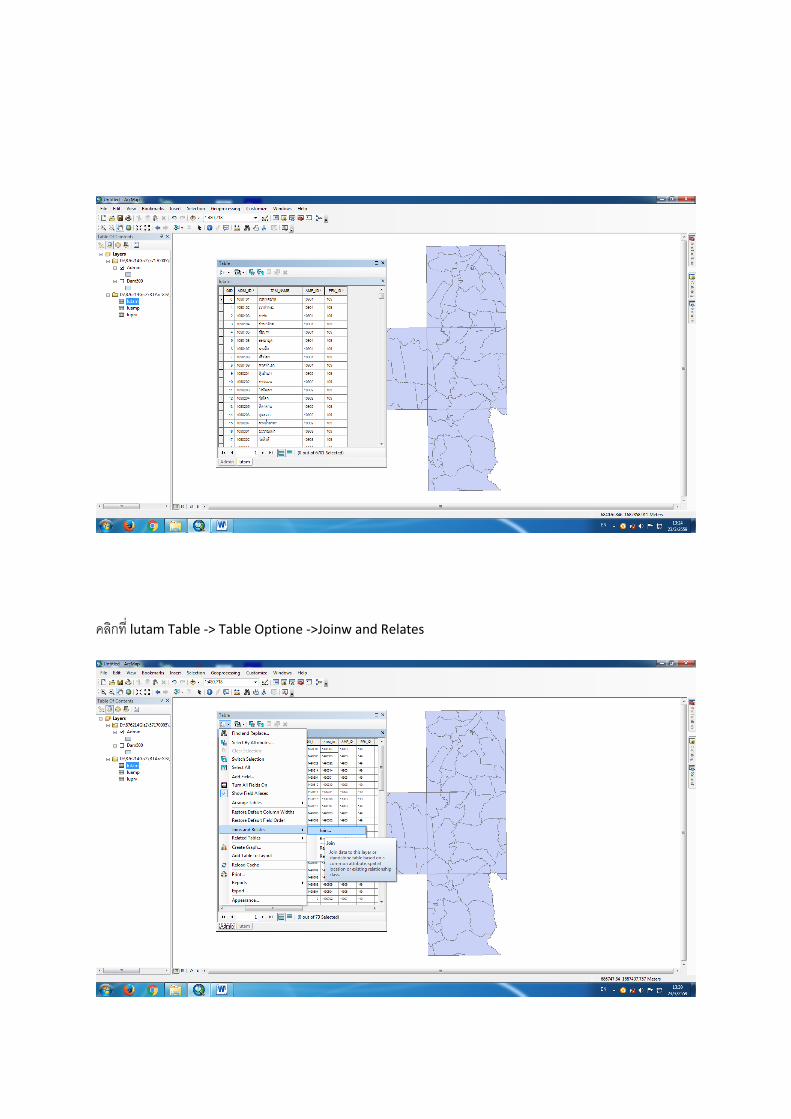
คลกิที่ lutam Table -> Table Optione ->Joinw and Relates

ช่อง->choose the field in this layer that the Join will be based on : เลอืก ADM_ID
ช่อง->choose the table to join to this layer,or load the table from disk : เลอืก lutam
ช่อง->choose the field in the table to base the join on : เลอืก ADM_ID

กด -> OK
คลกิ luamp-> Open

เป็นการ Join แบบ กลุม่ตอ่หนึง่
คลกิ luamp Table -> Table Optione ->Joinw and Relates

ช่อง->choose the field in this layer that the Join will be based on : เลอืก AMP_ID
ช่อง->choose the table to join to this layer,or load the table from disk : เลอืก luamp
ช่อง->choose the field in the table to base the join on : เลอืก AMP_ID แล้ว กด -> Ok
คลกิ luprv-> Open

คลกิ luprv Table -> Table Optione ->Joinw and Relates -> เป็นการ Join แบบ กลุม่ตอ่หนึง่
ช่อง->choose the field in this layer that the Join will be based on : เลอืก PRV_ID
ช่อง->choose the table to join to this layer,or load the table from disk : เลอืก luprv
ช่อง->choose the field in the table to base the join on : เลอืก PRV_ID แล้ว กด -> Ok

คลกิGeoprocessing->Clip

ช่องInput Features ->Adnim ช่อง Clip features -> Dam500 และช่อง Output feature class ->Saveที่ต้องการ
ช่ือ Addam500 แล้วกด ->Ok
Saveช่ือ Addam500 แล้วกด ->Ok

กด-> Ok
กด-> Close

เปิดข้อมลู Addam500 ไปท่ี table of contents
ตอ่ไปจะท าการMerge เลอืกเปิดขัน้ข้อมลูที่ช่ือ a5239iii , a5238iv , a5238iii , a5238i

คลกิ Geoprocessing -> Merge
ช่อง Input Datasets เลอืกน าข้อมลู a5239iii , a5238iv , a5238iii , a5238i เข้าไป แล้วSave ที่ต้องการ

Save -> ช่ือLand Use แล้วกด-> Ok
กด -> Close

เปิด ->Land use
คลกิ->Land use ->open Attribute Table

คลกิ เลอืกข้อมลู lucod ไปท่ี Table of contents
คลกิขวาที่ lucode -> Open

ได้ดงันี ้เป็นการ Join แบบ กลุม่ตอ่หนึง่
คลกิ Table Option ->Joins and Relates

ช่อง->choose the field in this layer that the Join will be based on : เลอืก LUCODE
ช่อง->choose the table to join to this layer,or load the table from disk : เลอืก lucode
ช่อง->choose the field in the table to base the join on : เลอืก LUCODE แล้ว กด -> Ok
ผลลพัธ์

คลกิ Geoprocessing ->Clip
ช่อง Input features -> Land Use ช่อง Clip features ->Dam500 ช่อง Outpue features class->Saveช่ีอที่
ต้องการ

Save-> Land Use500 แล้วกด OK
กด Close

เปิด Land Use ที่ Table of contente
คลกิเลอืก ชัน้ข้อมลู a5239iii , a5238iv , a5238iii , a5238i และ Land Use ออกจาก Table of contents

คลกิ Geoprocessing -> Intersect
ช่อง input features น าเข้าข้อมลู Land Use500 และ Addam500

ช่อง Output Feature Class -> Saveช่ือ Final แล้วSave
กด Close

คลกิขวา->Final ->Open Attribute Table
คลกิ ->Table Optione -> Add Field

ตัง้ช่ือ Name -> Area เปลีย่น Type -> Float เปลีย่น Precision ->15 เปลีย่น Scaie->4 แล้ว Ok
ได้ช่องใหม ่ช่ือArea ดงันี ้

คลกิขวาที่ช่อง Area -> Calculate Geometry…..
กด Ok

ผลลพัธ์หลงัจากค านวณแล้ว
คลกิ ->Table Optione -> Add Field

ตัง้ช่ือ Name -> Rai เปลีย่น Type -> Float เปลีย่น Precision ->15 เปลีย่น Scale-> 4 แล้ว Ok
คลกิขวาที่ช่อง Rai ->Field Calculator …

จะได้ตารางค านวณแบบนี ้เราจะค านวณหา จ านวนไร่ ด้วย [Area]/1600= แล้วจะได้จ านวนไร่ออกมา
จะได้จ านวนไร่ ดงันี ้

คลกิ Table Option -> select By Attributes….
ค านวณหา อ าเภอชยับาดาล และ พืน้ท่ีที่ปลกูข้าวโพด

ได้ผลลพัธ์ ดงันี ้
เปิด Microsoft Excel

เปิด ข้อมลู Open
เปิดไฟล์ข้อมลูที่เราบนัทกึไว้ช่ือFinal.dbf

จะได้ข้อมลู ดงันี ้
คลกิ Insert -> PivotTable

แล้วกด OK
จะได้แถบ PivotTable Field List ขึน้ท่ีมมุชวือ

ติกเลอืกข้อมลูที่ช่ือluprv_PRV1 คือ ให้แสดง ช่ือจงัหวดั
ติกเลอืก luamp_AMP1 ให้แสดงช่ืออ าเภอ ของแตล่ะจงัหวดั

คลกิเลอืก lutam_TAM เพื่อแสดงช่ือต าบล ของแตล่ะอ าเภอ
คลกิเลอืก Rai เพื่อแสดง จ านวนพืน้ท่ีของแตล่ะจงัหวดั อ าเภอ และ ต าบล โดยหนว่ยเป็นไร่

ติกเลอืก lucode_ASS เพื่อแสดงจ านวนพืน้ท่ีวา่เปลา่ ของแตล่ะจงัหวดั