5/17/2015 1:49:40 amunbc1. 5/17/2015 1:49:40 amunbc2
TRANSCRIPT
04/18/23 06:25 PM UNBC 1

04/18/23 06:25 PM UNBC 2

04/18/23 06:25 PM UNBC 3

04/18/23 06:25 PM UNBC 4

04/18/23 06:25 PM UNBC 5

04/18/23 06:25 PM UNBC 6
Chapter 6: Oceanic Circulation
Objectives: Ocean Structure Surface circulation --- Wind-driven Ocean
Circulation Deep circulation --- Salt-driven circulation:
Thermohaline Circulation
(Nov. 4, 2009)

04/18/23 06:25 PM UNBC 7
6.1 Ocean structure
Outline Size & shape of the oceanTemperature structure of the oceanSurface currentsOcean’s role in global heat transport
04/18/23 06:25 PM UNBC 8
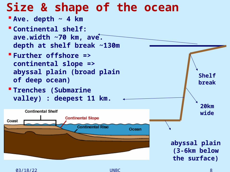
Size & shape of the ocean Ave. depth ~ 4 km Continental shelf: ave.width ~70
km, ave. depth at shelf break ~130m
Further offshore => continental slope => abyssal plain (broad plain of deep ocean)
Trenches (Submarine valley) : deepest 11 km.
abyssal plain(3-6km below the
surface)
Shelf break
20km wide

04/18/23 06:25 PM UNBC 9
Temperature TVertical profile:
•Solar radiation absorbed within 100m of sea surface.
•Wind => surface mixed layer of 50-200m, (T is nearly uniform).
•Thermocline occurs between 200-1000m depth: T decr. rapidly with depth.
•Below thermocline, T decr. very slowly to 0-3oC at oc. bottom.
thermocline->
Mixing layer

04/18/23 06:25 PM UNBC 10
Thermocline: The thermocline is the transition layer between the mixed layer at the surface and the deep water layer. In the thermocline, the temperature decreases rapidly from the mixed layer temperature to the much colder deep water temperature.
The mixed layer and the deep water layer are relatively uniform in temperature, while the thermocline represents the transition zone between the two.

04/18/23 06:25 PM UNBC 11
Vertical temperature section in Atlantic
North South
04/18/23 06:25 PM UNBC 12
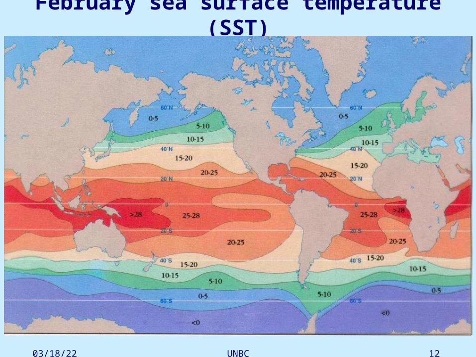
February sea surface temperature (SST)

04/18/23 06:25 PM UNBC 13
August sea surface temperature (SST)

04/18/23 06:25 PM UNBC 14
Hardly Cell Atmosphere is heated in the equator => Air becomes less dense and
rises => Rising air creates low pressure at the equator.
Air cools as it rises =>
Water vapor condenses (rains) as the air cools with increasing altitude => Creates high rainfall associated with the Intertropical Convergence Zone in the tropics (ITCZ).
As air mass cools it increases in
density and descends back to the
surface in the subtropics (30o N
and S), creating high pressure.

04/18/23 06:25 PM UNBC 15
Polar cell and Farrell cell In the pole area, the surface is much cold,
especially in winter. This results in increased air density near the surface => higher pressure. The higher density and pressure lead to divergence => surface air moves towards tropic. The cold air from pole will meet the warm air from Tropic around to form “Pole Front Zone.
For mass conservation, there are aloft circulations corresponding the surface circulations, which forms two cells, called Pole cell and Farrell cell.

04/18/23 06:25 PM UNBC 16

04/18/23 06:25 PM UNBC 17
Surface currentsGyres: Large horizontal circulation cells.

04/18/23 06:25 PM UNBC 18
04/18/23 06:25 PM UNBC 19
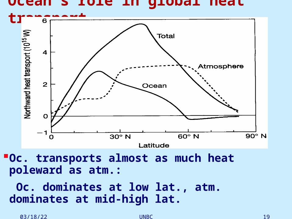
Ocean’s role in global heat transport
Oc. transports almost as much heat poleward as atm.:
Oc. dominates at low lat., atm. dominates at mid-high lat.

04/18/23 06:25 PM UNBC 20
Heat capacity: amount of energy needed to raise temp. of a unit mass by 1°C.
Water has a high heat capacity:
•Temp. range over land many times that over oc., as heat cap. of water much larger than that of soils/rocks.
•Oc. heat capacity ~1600 times of atm.

04/18/23 06:25 PM UNBC 21
Oc. has strong moderating effect on climate, e.g. coastal regions milder than inland.
Large heat capacity => difficult to change oc. => oc. has long "memory" & major role in climate time scale, where atm. becomes "slave" to oc.

04/18/23 06:25 PM UNBC 22
6.2 Wind-driven Ocean Circulation
-- Ekman motion and Ekman Spiral.
-- Upwelling & downwelling.
-- Geostrophic currents.

04/18/23 06:25 PM UNBC 23
Inertial Motion
No external forces => pressure gradient and wind stress disappear.

04/18/23 06:25 PM UNBC 24

04/18/23 06:25 PM UNBC 25
Ekman MotionEkman assumed a steady, homogeneous,
horizontal flow with friction on a rotating Earth. Thus horizontal and temporal derivatives are zero.

04/18/23 06:25 PM UNBC 26
Wind stress: Often we are much more interested in the force of the
wind, or the work done by the wind. The horizontal force of the wind on the sea surface is called the surface wind stress. The force per unit area that wind exerts on the surface of the ocean.
Coriolis Force = Wind stress
Wind stress = tangential force on a unit area of oc. surface When the surface water moves, it drags along the water just below it, making the water just below it moving.

04/18/23 06:25 PM UNBC 27
V0 is the velocity (wind is blowing to the north) of the wind at the sea surface
Now let's look at the form of the solutions. At the sea surface z = 0, exp(z = 0) = 1, and

04/18/23 06:25 PM UNBC 28
The current has a speed of V0 to the northeast. In general, the surface current is 45° to the right of the wind when looking downwind in the northern hemisphere. The current is 45° to the left of the wind in the southern hemisphere. Below the surface, the velocity decays exponentially with depth:

04/18/23 06:25 PM UNBC 29
04/18/23 06:25 PM UNBC 30
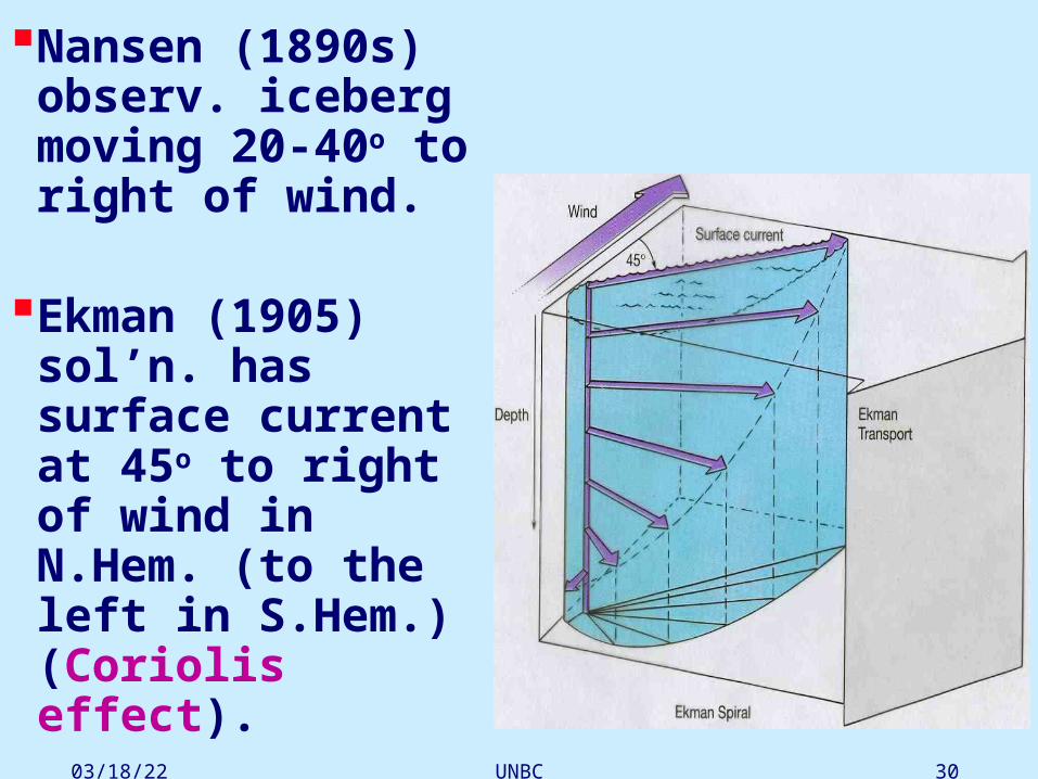
Nansen (1890s) observ. iceberg moving 20-40o to right of wind.
Ekman (1905) sol’n. has surface current at 45o to right of wind in N.Hem. (to the left in S.Hem.) (Coriolis effect).

04/18/23 06:25 PM UNBC 31
On surface, the moving is at just 45 degree to the right of wind; at subsurface, a thin layer below surface, the moving is at an angle which is larger than 45 degree to the right; With the increase of depth, the angle become lager and lager until the current moves just opposite to surface current at some depth (around 100m). This is called Ekman Spiral.
Ekman layer: from surface to some depth where the current moves at the direction opposite to the surface current.

04/18/23 06:25 PM UNBC 32
Ekman Mass Transports
Flow in the Ekman layer carries mass. For many reasons we may want to know the total mass transported in the layer. The Ekman mass transport ME is defined as the integral of the Ekman velocity UE, VE from the surface to a depth d below the Ekman layer. The two components of the transport are MEx, MEy:

04/18/23 06:25 PM UNBC 33
The transport is perpendicular to the wind stress, and to the right of the wind in the northern hemisphere.

04/18/23 06:25 PM UNBC 34
Application of Ekman Theory

04/18/23 06:25 PM UNBC 35
Upwelling & downwellingWind blowing
alongshore can generate offshore Ekman transp.
=> upwelling
Onshore Ekman transp. => downwelling

04/18/23 06:25 PM UNBC 36
Along Equator, Easterlies => Ekman transport away from Eq. => strong upwelling along Eq.

04/18/23 06:25 PM UNBC 37
Upwelling under cyclones
Downwelling under anti-cyclones.
04/18/23 06:25 PM UNBC 38
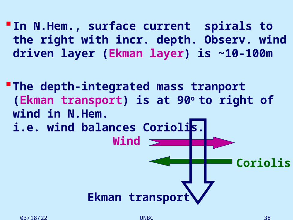
In N.Hem., surface current spirals to the right with incr. depth. Observ. wind driven layer (Ekman layer) is ~10-100m
The depth-integrated mass tranport (Ekman transport) is at 90o to right of wind in N.Hem. i.e. wind balances Coriolis.
Wind
Coriolis
Ekman transport
04/18/23 06:25 PM UNBC 39
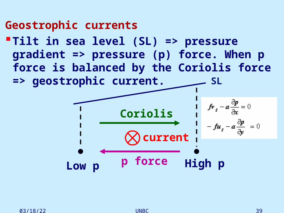
Geostrophic currentsTilt in sea level (SL) => pressure gradient =>
pressure (p) force. When p force is balanced by the Coriolis force => geostrophic current.
Coriolis
p force
SL
current
Low p High p

04/18/23 06:25 PM UNBC 40
High p
Gradual buildup of a geostrophic current:
Low p
High pLow pp force
current
Coriolis force
Coriolis force
p force

04/18/23 06:25 PM UNBC 41
N.Hem.: low lat. easterlies, mid lat. westerlies => converging Ekman transport & high sea level (SL)
at ~30°N
=> geostrophic currents.
45°N
30°N
15°N
H
Ekman transp.
High SL H
p force
geostrosphiccurrent
Coriolisforce
04/18/23 06:25 PM UNBC 42
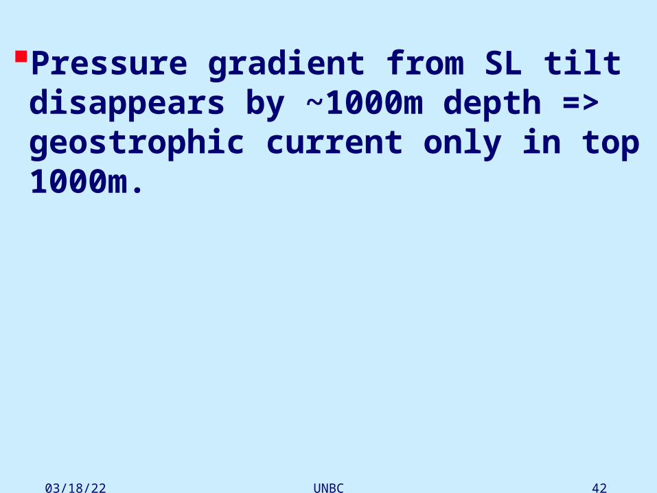
Pressure gradient from SL tilt disappears by ~1000m depth => geostrophic current only in top 1000m.

04/18/23 06:25 PM UNBC 43
3 forces in upper ocean:
wind stress, pressure gradient, Coriolis
In Ekman layer (top 100m) mainly Coriolis balancing wind stress.
100-1000m: mainly Coriolis balancing pressure gradient => geostrophic current.

04/18/23 06:25 PM UNBC 44
SL measurements from satellite
Altimeter: measures return time of radar signal => distance to sea level => hills and valleys in the SL => geostrophic currents.
satellite
SL
L
H
geostrophic current

04/18/23 06:25 PM UNBC 45
6.4 Deep circulation --- Thermohaline
Composition of “salt” in oc.Distr. of salinity in oc.What affects density of sea water

04/18/23 06:25 PM UNBC 46
Salinity:
measured in terms of the proportion of dissolved salt to pure water.
(unit: g salt /kg seawater)
0

04/18/23 06:25 PM UNBC 47
Salinity S Ave. concentration of salt in sea water (i.e. S) is ~3.5%. Until early 1980s, S expressed in parts per thousand, 3.5%
written as 35 o/oo. The o/oo symbol now discarded. Major constituents of S:
%
Chloride, Cl- 55.0
Sodium, Na+ 30.6
Sulphate, SO4-2 7.7
Magnesium, Mg+2 3.7
Calcium, Ca+2 1.2
Potassium, K+ 1.1
99.3

04/18/23 06:25 PM UNBC 48
How to measure salinity?
• Get rid of the water and weigh the salts left behind. Unreliable.
• Higher S => more ions => incr. elec. conductivity (i.e., electric current passes much more easily through water with a higher salt content. So if we know the conductivity of the water, we know how much salt is in the water).
Since mid-1960s, measure conduc. to get S.
• S measured by a CTD (Conductivity-Temperature-Depth) probe.

04/18/23 06:25 PM UNBC 49
As the CTD instrument is lowered through the water (or as it sits still at a given point), measurements of conductivity, temperature and depth are recorded continuously.
CTD instruments measure three important quantities directly - conductivity, temperature and pressure. By measuring conductivity => salinity.
04/18/23 06:25 PM UNBC 50
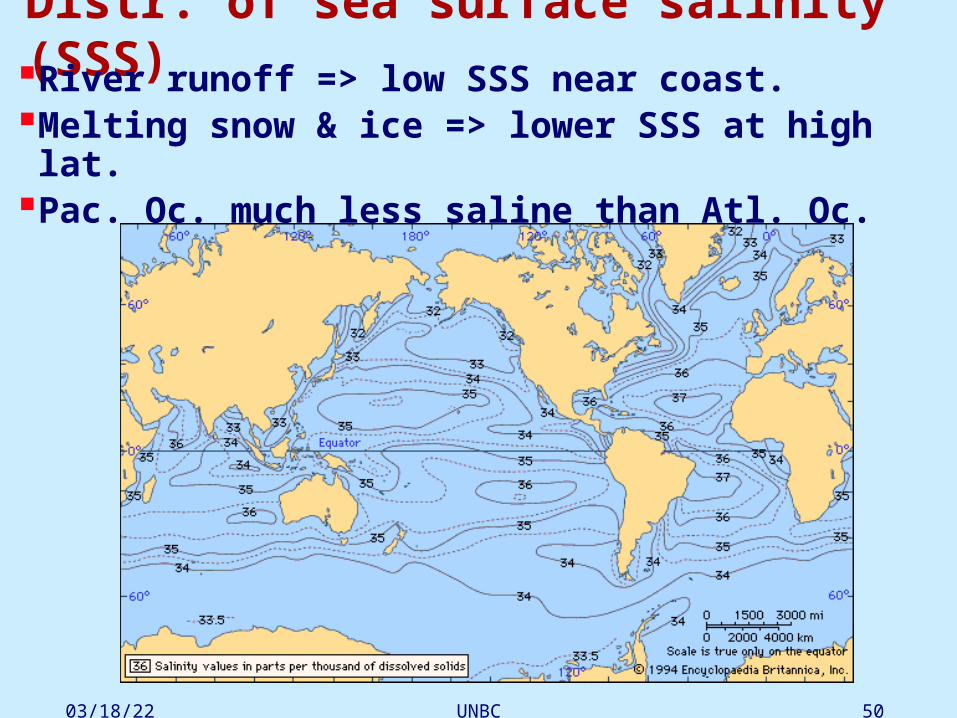
Distr. of sea surface salinity (SSS)River runoff => low SSS near coast.Melting snow & ice => lower SSS at high lat.Pac. Oc. much less saline than Atl. Oc.

04/18/23 06:25 PM UNBC 51
Lat.distr. of SSS follows Evap.-Precip. (E-P) .

04/18/23 06:25 PM UNBC 52
Vert. distr. of S
Halocline = region of strong change of S with depth, at ~ 200m-1000m.
Typical halocline: Low lat., S decr.with depth High lat., S incr. with depth
Salinity Temperature

04/18/23 06:25 PM UNBC 53
In Equator and tropical area: the surface accept a lot heating from the sun to evaporate water, so the S is large. With increase of depth, the evaporation rate decrease so S decrease too. So, the S distribution is similar to distribution of temperature.
In high latitude, snow and ice melt which makes S low in surface than deep water. So S increase with the depth.

04/18/23 06:25 PM UNBC 54
Density
In open oc., density ~1.022-1.030 g/cm3.
Density determined by T, S & pressure .
At mid & low lat., density profile approx. T profile.
Thermocline => pycnocline (where density changes rapidly with depth).
Salinity Temperature

04/18/23 06:25 PM UNBC 55
In equator and tropical regions, there is usually a shallow upper layer of nearly uniform density, then a layer where the density increases rapidly with depth, called the pycnocline. Normally, as the density is up to 27.9, there is little variation of density with depth. In high latitude where density is over 27 => there is little variation of density with depth.

04/18/23 06:25 PM UNBC 56
TS diagram:
T-S-Density relation.
At low T, changing T has little effect on density.
Salinity
Tem
per
atu
re

04/18/23 06:25 PM UNBC 57
Bottom water formation• surface water: 0-500 m deep, • intermediate water: 500-1500 m, • deep water: 1500-3500 m, • bottom water: > 3500 m
What conditions needed to form bottom water? (a) intense cooling, or (b) incr. in S. Usu. both (a) & (b) required. Polar regions during winter: cooling and windy cause
dense water (strong wind will evaporate water and leave salt behind) (cool and salty water);
When sea water is frozen into ice, much of salt expelled into surrounding water, since ice can’t contain the salt. So the water underlying the sea ice is very relatively salt.

04/18/23 06:25 PM UNBC 58
There are two important regions to form deep water. North Atlantic and Antarctic because they are very cold, and windy. The dense water masses that sink into the deep basins are formed in quite specific areas of the North Atlantic and in the Southern Ocean.

04/18/23 06:25 PM UNBC 59
By contrast in the Weddell Sea off the coast of Antarctica near the edge of the ice pack, the effect of wind cooling is very intense. The resulting Antarctic Bottom Water (ABW) sinks and flows north into the Atlantic Basin. The flow into the Pacific is blocked.
Bottom water formed off Antarctica, mainly in Weddell Sea.
Antarctic Bottom Water (ABW) is densest water in open oc.

04/18/23 06:25 PM UNBC 60
N.Atlantic: North Atl. Deep Water (NADW) mainly formed in Norwegian & Greenland Seas.
In the Norwegian Sea evaporative cooling (large wind leading to strong evaporation and in turn leading to large salinity) is predominant, and the sinking water mass, the North Atlantic Deep Water (NADW), fills the basin and moves southwards. It then flows very slowly into the deep abyssal plains of the Atlantic, always in a southerly direction.
04/18/23 06:25 PM UNBC 61
N.Pacific is too low in S to form bottom water. Cooling in high lat.=> intermediate water.
The Pac. bottom water (the Common Water) is a mixture of NADW & ABW, introduced into the Pac. by the Antarctic Circumpolar Current.

04/18/23 06:25 PM UNBC 62
NADW flows southward through the Atlantic Oc. And joins with Antarctic Circumpolar Current, which flows around Antarctica. There the NADW and ABW combine and circle the continent. They then proceed to branch off into the Indian and Pacific Oceans.
Flow pattern at 4000 meter

04/18/23 06:25 PM UNBC 63
04/18/23 06:25 PM UNBC 64
Thermohaline circulationThermohaline circulation: The density of sea water is controlled by its
temperature (thermo) and its salinity (haline), and the circulation driven by density differences is thus called the thermohaline circulation. The thermohaline circulation is sometimes called the ocean conveyor belt, the global conveyor belt, or, most commonly nowadays, the meridional overturning circulation.
Top 1 km dominated by wind-driven oc. circ., below 1 km, thermohaline
circ. dominates.

04/18/23 06:25 PM UNBC 65
Originally the deep water is formed in North Atlantic, near Greenland, iceland and Norwegian sea (NADW). The NADW sinks into bottom and then further moves southward. The NAWD will move to Antarctic region and merge with ABW (Antarctic bottom water), and move northward to arrive at the North Pacific. Meanwhile, the surface current near the western Pacific ocean moves southward in the form of gyre, and further cross Indian ocean and back to Atlantic ocean to replace water there sinking into bottom.
So, the thermohaline circulation includes a deep ocean circulation from the North Atlantic Ocean to the North Pacific to bring deep water (salty and cold) into Pacific
Ocean; and a surface current from the North Pacific to North Atlantic ocean. Both circulations act to make the water mass conservation.

04/18/23 06:25 PM UNBC 66
The effect of Thermohaline circulation on climate
(1) THC transports heat from the south to North to warm the North Atlantic and Europe.
(2) adjust the low latitude climate too by transporting surplus heat

04/18/23 06:25 PM UNBC 67
Change in annual temperature 30 years after a collapse of the thermohaline circulation