5.0 settlement groups - manitoba · source: manitoba historical atlas, page 330. hrb map #042.)...
TRANSCRIPT

36
5.0.2 Above: "Foreign Groups on the Prairies" in 1929.The areas outlined are those in which the groups still retained to some extenttheir old-world practices and languages, at the time the map was produced. Keyto symbols (in the study region) include: Men -Mennonites; UK -Ukrainians; IC -Icelandic; SC -Scandinavians; B -Belgians; Ruth -Ruthenians; Hun -Hungarians; G -Germans.
The terms Ruthenian, Galician, and Ukrainian actually refer to the same culturalgroup. Around 1930, Ruthenian, Galician and even Austrian were dropped fromofficial use in Canada in favour of the term 'Ukrainian'. French and British settleddistricts are not noted in the map, as these were not considered at the time to be"foreign" groups. Although the original map attempted to show a large number ofethnic groups in all three of the Prairie Provinces, it appears to be relativelyaccurately drawn. In the study region, it quite accurately shows the relative extentand location of the Mennonite and Ukrainian settled areas, as well as the smallerGerman district just east of Emerson, and the short-lived and little-knownIcelandic settlement in the Arbakka district south of Vita. Note the lack of"foreign" group settlements in the southwestern portion of the province.(Map Title: Foreign Groups on the Prairies in 1929. Source: Manitoba Historical Atlas,page 330. HRB Map #042.)
5.0.1 Above: Settlement Groups in Southeastern ManitobaGeneralized map showing the districts occupied by the early settlement groups in thestudy region. The original ethnic component of these various enclaves is still reflected bythe place names bestowed on the communities and post office locations by the earlysettlers. (Historic Resources Branch map.)
5.0 SETTLEMENT GROUPSBlock Settlements
One of the more interesting aspects of the Crow Wing Study Region is itsethnic diversity. At least five major ethnic groups settled in the region, includingAboriginal, Mennonite, Anglo-Ontario, French, and Ukrainian. Smaller settlements alsowere established by French Métis, German, and Icelandic settlers. Most of thesegroups are still well represented in the region, and while acculturation and assimilationhave reduced their original distinctiveness, the multi-ethnic nature of the region is stillquite evident. Together with parts of the Interlake Region, this portion of the provincelikely possessed the most diverse settlement populations of any region in Manitoba.
Initially these diverse groups settled in homogenous block settlements, bothlarge and small, but in time the boundaries between the various communities began toblur as subsequent generations purchased farmland, homes, and businesses outside ofthe initial settlement areas. The initial slow pace of assimilation increased rapidlyduring the 1950s and 1960s with the advent of highway transportation and the resultantcentralization of services. School consolidation, during the mid-1960s, forced theclosure of many small rural schools in favour of large centralized ones, thus quickeningthe breakdown of cultural boundaries. Inter-marriage between the groups, at first quiterare, became commonplace by the 1960s and 1970s.
Surviving Cultural SignpostsDespite this blending of the original settlement groups in recent decades, the
early cultural mosaic of the Crow Wing Study Region is still quite evident. Communityplace names, such as Tolstoi and Senkiw in Ukrainian-settled areas; Steinbach, NewBothwell, and Grunthal in the Mennonite-settled areas; and Lorette, Ste. Anne,Marchand and La Broquerie in the French-settled areas, provide the most obviousdemonstration of the region's cultural matrix. Similarly, with the recent move to thenaming of most municipal roads in the province, cultural nomenclature has becomeeven more obvious in the region. The cultural distinctiveness of the various districtscontinues to be preserved through language, particularly in the Francophone areas,where French is heard in daily use. And, although less prevalent, Ukrainian andGerman can frequently still be heard at social gatherings and in the home. The multi-cultural component is preserved and celebrated in the many community festivals heldthroughout the region. Popular events such as the St. Pierre Frog Follies, SteinbachPioneer Days, the Gardenton Ukrainian Festival, and The Roseau River 'First NationsPow Wow' commemorate and celebrate the cultural diversity of the region, withtraditional food, crafts and entertainment. Finally, the region's cultural diversity ispreserved in the surviving early architecture, in heritage villages such as the MennoniteVillage Museum, or on the grounds of the former Convent of the Holy Names in St.Pierre-Jolys, or in surviving early farmstead structures and church buildings scatteredthroughout the region. The many distinctive doomed churches of the Ukrainian Catholicand Greek Orthodox faith, in the Ukrainian settled areas, are particularly evident, as arethe tall spires and Gothic styling of the many Roman Catholic churches in theFrancophone areas of region.

37
5.0.4 Above: Manitoba in 1870 Map showing the extent of settlement in Manitoba in 1870 just prior to the arrival of immigrant groups from eastern NorthAmerica and Europe. (Map Title: Settlement in Manitoba, 1870. Source: Economic Atlas of Manitoba, page 29. HRB Map #033.)
5.0 Settlement Groups
5.0.3 Above: Free HomesteadsCopy of a ‘Free Homesteads’ advertisement included on the backside of a Map of Manitoba published in 1887. The advertisement wasaccompanied by a summary of homestead regulations, descriptions of Manitoba, the City of Winnipeg, and glowing opportunities for farming inthe province. Such maps were distributed throughout North America and Western Europe to help entice immigrants to the province. (Map Title:Railway & Guide Map of Manitoba Published by Authority of the Provincial Government, Winnipeg, March 1887. Source: Provincial Archives of Manitoba: H3614.2 gme 1887 c.2.)
5.0.6 Above: The Homestead After Two Years According to promotional literature at the time, after two years on their prairie homestead,the pioneer family would now have possess a small home and barn, a large garden andorchard, and a growing herd of livestock. (Source: Provincial Archives of Manitoba)
5.0.5 Above: Breaking the Prairie and Erecting a HomesteadThese idealized illustrations show the progression of habitation on the Canadianprairies, and were often used in immigration literature to help entice settlers to thewest. In this illustration, the first crop is being prepared while other members of thepioneer group construct a small frame house. (Source: Provincial Archives ofManitoba)
5.0.7 Above: The Homestead After 15 Years Fifteen years after settling on their prairie homestead, the pioneer family now has a large barnand substantial house with a mature orchard and landscaped yard, numerous livestock, abumper crop of grain stooks, and nearby neighbours. In reality, homesteading on the prairieswas not usually so prosperous, and after years of hard work many families simply gave upand walked away from their homesteads. (Source: Provincial Archives of Manitoba)

38
5.0 Settlement Groups
5.1 Métis SettlementThe study region’s first agricultural settlers were made up of two mixed-blood groups: the Métis and the Country-born,
both of whom were in effect, “the children of the fur trade”. The first and largest group were the French-speaking RomanCatholic Métis, and of French-Aboriginal ancestry. The second mixed-blood group were the children of Native women andHudson’s Bay Company employees or Selkirk Settlers. These ‘Country Born’ were English-speaking and of the Protestantfaith. By 1870, the Métis were the predominant cultural group living in the Red River region, numbering about 10,000individuals. The main livelihood of the Métis and Country-born had been the provisioning of the fur-trading posts of theNorth West and the Hudson’s Bay companies. For decades, the life of the community revolved around small farmingoperations, the annual buffalo hunt, and working in the fur trade. The Métis are best known for their involvement with theHudson’s Bay Company brigades of Red River oxcarts and the freighting life of the Saskatchewan, Pembina and CrowWing trails.
The core of the Métis community and culture in Manitoba was the Red River Settlement, particularly St. FrançoisXavier and St. Norbert parishes. However, as early as the 1820s, a handful of small riverfront settlements were beingestablished in selected areas along the banks of the upper Red, the Seine, the Rat, and the Morris rivers. These loosely -knit communities were initially established as family wintering locations, where shelter and firewood could be found, andhunting was possible to help sustain the family over the difficult winter months. It was the fear of losing their claim tothese riverfront properties, as well as linguistic and educational rights, that led to the Red River Resistance and eventuallyto The Manitoba Act of 1870. Several of these unofficial river-lot settlements managed to become permanent settlements,such as St. Norbert and Ste. Anne, albeit with the help of later arriving French Canadian settlers. Others, such as St.Joseph on the Pembina River in North Dakota, and St. Daniel on the Boyne River near Carman, largely disappeared asthe Métis moved to their individual Scrip land entitlements, or sold their land and moved away.
Under the terms of the Manitoba Act, which created the Province of Manitoba, several million acres of land insouthern Manitoba were set aside as Métis ‘Scrip’ land reservations. Eligible members of both the Métis and Country-born community were granted 100 hectare (240 acre) parcels of land. Much of the Scrip was allotted by randomselection, resulting in family members receiving land in widespread locations. Few Métis chose to settle on the propertygranted to them. Most traded with others or, more often, sold their land to real estate agents, individual settlers, and eventhe Catholic Church in St. Boniface, which purchased large amounts of Scrip land. No doubt, some were swindled out oftheir land, or lost it as a result of non-payment of municipal taxes, etc. A great many families chose to move west to less-populated and less ‘civilized’ regions, particularly at Batoche near the forks of the North and South Saskatchewan rivers.This out-migration during the late 1870s greatly reduced the Métis presence in the Red River valley. With the arrival ofmany French Canadian settlers, the Métis in the Red River valley largely merged with the more populous Francophonecommunity. Métis presence and culture never completely died out, however. Currently, cultural festivals, such as theFestival du Voyageur and Red River Days, keep Métis traditions and heritage alive and popular.
The Métis presence was quite strong in the study region. As early as the 1820s, families were wintering in the Pointedes Chênes (Ste. Anne) area and establishing permanent settlements along the Red River in the St. Norbert area. Duringthe 1850s when the Crow Wing Trail came to be more extensively used, several Métis families established homes wherethe trail crossed or came close to the Rat River. As well, scattered Métis settlements occurred along the east side of theRed River south of St. Norbert, as far south as the American border. Also, approximately 16 townships of Métis Scripland was set aside in the study region in two large blocks, located north and south of the Mennonite East Reserve, whichwas reserved at the same time. Until all the Scrip lands had been fully distributed, these districts remained largelyunsettled and unavailable to incoming settlers. Much of it remained unoccupied, even after being sold, having beenpurchased by investors intent on resale, rather than farmers intent on settlement.
There are few known visible physical remnants of the Métis presence and culture in the study region. All that appearsto remain are two early homes, belonging to former Métis freighters, which recently have been saved from destructionthrough municipal heritage site designations:
1. Maison Moïse Goulet2. Maison de la Montagne
5.1.1 Right: Land ReservesDetail from a map of Manitoba showing the Métis Scrip reserves located in southcentral Manitoba (outlined in Red). Black quarters indicate registered homesteads,'crosses' indicate pre-emptions, and Xs indicate military grants. Note the effect theScrip land had on confining early Anglo-American settlement to the extremesouthern and northern portions of the study region, and the Mennonite settlement tothe East Reserve areas (outlined in blue.) Note also the early Métis settlementswithin the Scrip Reserve in the La Rochelle and Lorette areas.(Map Title: Map Showing the Townships Surveyed in the Province of Manitoba and NWTerritory in the Dominion of Canada, April 15, 1877. Source: PAM # H5 614.1 fbe 1877 Copy2. HRB Map #012.)

39
5.0 Settlement Groups
5.1.4 Above, right and below: Métis LifestylesViews of typical scenes in the Métis settled areas of the Red River valley duringthe 1850s and 1860s. (Source: Provincial Archives of Manitoba.)
5.1.3 Above: Métis StructuresThe former Moïse Goulet house, now located on the grounds of the former Convent of the Sisters of theHoly Names in St. Pierre-Jolys, is a protected municipal heritage site and has been restored to its originalappearance. Mr. Goulet was a freighter with the HBC oxcart brigades, and built this house when he retiredin 1870. (Photo: Historic Resources Branch.)
5.1.2 Above: Métis StructuresThe structure now locally known as La maison de la Montagne, was originally owned by relatives of LouisMalo, who founded the community of St. Malo. The 'gambrel' shaped roof, like the 'mansard' roof, ischaracteristic of early homes in Manitoba constructed by French-speaking settlers. This structure wasrecently designated a municipal heritage site by the Municipality of De Salaberry. The current owner hasplans to restore the structure for use as a family cottage or vacation rental property. (Photo: Historic ResourcesBranch.)

40
5.2 Anglo-American SettlementAfter the troubles of 1870 had subsided, and the surveying of what was now the new Province of
Manitoba had resumed, the number of settlers making their way to the new prairie province began to grow.From 1871 to 1874 most of the new settlers, hailing from southern Ontario, arrived in small groups of four orfive families. Many of these early Ontario settlers had been volunteers in the Wolsley Expedition, sent fromeastern Canada to quell the uprising at Red River. Upon being discharged, each member of the force wasprovided with a Military Bounty Grant, which entitled them to a free land grant of a quarter section (160 acres)of land. Several hundred veterans of the Expedition seized the opportunity given them, and after investigatingthe available lands in the Red River region, registered their claims to selected prime locations throughoutsouthern Manitoba. After erecting makeshift structures, and preparing a small field for cultivation, they wouldinvariably return to Ontario to collect families and friends before returning and settling permanently. Severallocations along the western side of the Red River were popular Military Grant areas, with the Morris area andthe Dufferin/West Lynn area near Emerson, just outside the study region, being among the earliest settled byAnglo-Ontario families. The Clearsprings Settlement, near present-day Steinbach, and locations near andalong the Roseau River, in the study region, were other areas established by these early settlers fromOntario. Organized group settlement in Manitoba did not commence until 1874, when colonization societiesand 'for-profit' settlement schemes enticed thousands of land hungry settlers from Europe and eastern NorthAmerica to Manitoba and 'The Last, Best West'.
While most of the English-speaking settlers making their way to southern Manitoba at this time were ofOntario extraction, there was also a considerable number of American settlers, and American investment inthe lands of the study region. Emerson was established in 1873 by American investors who saw the strategicvalue of the site where the Red River crossed the international boundary. After acquiring settlement rights totwo townships east of the Red, the Americans promoted settlement and established businesses there as acommercial venture. With the completion of the Pembina Branch of the CPR in 1879, access to the regionwas easy for settlers, and despite the problem of surface water on the ‘flats’ east of the town, Anglo-Ontarianand American settlement spread quickly throughout the area, extending to the north, up to and just beyondDominion City on the Roseau River, and as far east as Stuartburn. Many of the homestead claims in thatarea were abandoned or sold to the later arriving Ukrainians, since much of the land above 'the ridge' proveddifficult for crop cultivation, even if the riverside locations were naturally idyllic sites.
The area north of the Roseau River was largely set aside as Métis Scrip entitlement, which initially heldup land sales and transfers in that area. As well, large portions of this area were quite low and wet holding upgeneral settlement and development until being drained by municipal and provincial drainage projects. Oncedrained, this district supported several large American-owned ‘bonanza farms’ which functioned for a numberof years in the Arnaud area during the early 1900s. These were operated by hired local labour, andadministered by a manager paid by the American owners. Eventually the bonanza farms were broken up andsold to different buyers. Much of this land was sold to Mennonites, new arrivals from Russia, and second-generation farmers from the East and West Reserves. Overall, there was a great deal of general landspeculation in the east Red River valley, with much of the land being tied up by foreign owners. The situationdelayed development of several districts in the region, and explains why there were, and continues to be,relatively few farmsteads established in the districts north of Dominion City.
In general, the ‘Anglo’ influence on the landscape was confined to the south end of the valley and uponthe higher land, along and nearer to the old beach ridge. Emerson and Dominion City, with their architectureand place names, were and continue to be a strong Anglo presence in the region. Other smaller communitiessuch as Greenridge, and Ridgeville, were primarily of Anglo background as well.
Sites noteworthy for their portrayal of Anglo-American settlement:1 – Emerson sites:
Emerson Court House and Town HallFormer Bryce HouseFormer Presbyterian manseFormer Creton TerraceFormer Masonic Lodge
2 – Dominion City sites:Former Methodist Church/MuseumDr. M.C. O'Brien residence (1903)Queen's Hotel
5.2.1 Anglo StructuresSome of the buildings in the Town ofEmerson noteworthy for their portrayal ofthe Anglo-American heritage of thecommunity and surrounding districtinclude: former Fairbanks House (above);Court House & Town Hall (right); and theformer Emerson Masonic Lodge (below).(Photos: Historic Resources Branch.)
5.0 Settlement Groups

41
5.0 Settlement Groups5.2.3 Right: Original plan of Dominion CityAs with Emerson, Dominion City's street names reflect thecommunity's Anglo origins, with such names as Queen,Ontario, Park, Prince, Lorne, and Dufferin. The substantialsize of the town survey was a reflection of the generalenthusiasm and optimism of the late 1870s. At the time oftheir initial formation Emerson and Dominion City weresituated along the only railway line leading into the Canadianprairies and it was felt that this advantage and the fertilelands of the Red River valley would guarantee a prosperousfuture for the towns. While Dominion City did prosper for atime it never attained the size and stature which its earlyresidents hoped it would and which the town’s namesuggests. Because of the routing of the line through thecentre of section 20, each of the three landowners involvedhad their property surveyed into town lots, resulting in three'Estates', each with a slightly different plan.
Being one of the first railway towns in western Canada, CPRofficials apparently adopted some of the elements of theDominion City town plan and used them as 'standard'components for the countless CPR surveyed communitieslocated along the CPR mainline and branch lines. Theseincluded: numbered streets, named avenues, the maincommercial lots facing the tracks, and the use of rectangularrather than square-shaped blocks. These elements were allpresent in the Waddell Estate, which appears to have beenthe model for the CPR plan. (Map title: Map of Part of FranklinMunicipality Showing Drains Etc, January 1883, with detail: showingDominion City Town Plan. Source: PAM #: H9 614.21 Fr gbbd 1883.HRB Map # 025b.)
5.2.5 Left: Standard CPR town plan: Belmont, ManitobaThe plans of the vast majority of prairie towns were directly affected bythe railroad. The prevailing grid-iron layout was invariably oriented to therailroad track, with the lots facing the track usually intended for thebusiness section. Later, if the town grew, one of the streets perpendicularto the railroad often became a business street as well. Eventually, if thetown continued to expand, the land on the far side of the track would besubdivided into residential lots. Belmont, Manitoba surveyed when therailroad went through in about 1890, illustrates these typical features.The village plan is fitted into the section survey, but the street pattern isoriented to the railroad. This standard form was repeated innumerabletimes across the prairies with only minor variations, and apparently hadits origins in part of the town plan for Dominion City. (Plan Title: Village ofBelmont. Source: Province of Manitoba, Department of Public Works, HighwaysBranch, 1956. HRB Map #092.)
5.2.4 Above: Standard CPR town Plan Sandford Flemming's design for town and village plots on the prairies. 1877. (Source: Historical Atlas ofManitoba, page 368. HRB Map #048.)
5.2.2 Below: Emerson Town PlanSurvey plan of the Town of Emerson showing several noteworthy items, including the street plan of theformer community of West Lynn, located on the west bank of the Red River, which for a time rivaled theTown of Emerson and was heavily promoted by the Hudson’s Bay Company which owned a large block ofland in the area. Note that the street system in Emerson is laid out as a uniform grid, except whereaffected by the railways. The nature of the street names, which consisted of numbered streets andavenues with names such as King, Archibald, Dominion, Park, Rupert, etc. also reflects the town’s Angloheritage. This plan also shows the flood protection dike encircling much of the community whichnecessitated the closure of several streets, including all of Victoria Street and Rupert Avenue, and theremoval of numerous early town structures. (Plan Title: Town of Emerson. Source: Province of Manitoba,Department of Public Works, Highways Branch, May 1961. HRB Map #092c.)

42
5.3 French River-lot SettlementsThe area contained within the Crow Wing Study Region includes one of Manitoba’s largest French settlement enclaves.
Beginning with the French explorers, continuing with the Métis riverfront settlements and wintering camps, and finally blossomingwith thousands of mostly expatriate French Canadians from the New England states, the Francophone presence in the Crow WingRegion is a long and highly colourful one.
Beginning in 1872, the Roman Catholic Church began actively to promote French settlement to help preserve andstrengthen the language rights won in the Manitoba Act of 1870, which created the Province of Manitoba. The St. BonifaceDiocese, under the leadership of Archbishop Taché, had hoped to create a solid block of French-speaking Roman Catholiccommunities in southeastern Manitoba. Although that dream ended with the creation of the Mennonite East Reserve in 1874, inthe heart of the southeastern region, several thousand French settlers were enticed to come to Manitoba. Through the Société deColonisation de Manitoba, the Roman Catholic Church authorities in Manitoba were able to arrange for the creation of specialriver-lot settlements to be carved out of the township grid. Six such settlements were eventually established, including the Ste.Anne, Lorette, and Grande Pointe settlements along the Seine; the Rat River (St. Pierre) and St. Malo settlements along the RatRiver; and finally, an unusual situation in which the Ile de Chêne Settlement was established along a segment of the former OakRiver channel.
As well, two townships and adjoining river lots along the Red River, south of the old parish settlement at St. Norbert, weresecured for French settlement and soon gave rise to the communities of St. Adolphe and Ste. Agathe. In a similar fashion, thearea between the Ontario enclaves in the Emerson and Morris districts was secured and eventually developed into the currentcommunities of St. Jean Baptiste and Letellier. In support of these and other French settlements, the Roman Catholic Churchauthorities were actively involved in real estate dealings throughout southern and southeastern Manitoba, and were involved in thepurchase and resale of large amounts of Métis Scrip land in the region. Other, smaller Francophone communities established inthe study region include: Giroux, La Broquerie, and Marchand along the upper Seine River; and Arnaud, Aubigny, St. Elizabeth,and Dufrost in the area between the Rat and Red rivers.
The long-lot survey was the dominant system of land division in Québec since its founding. When the Selkirk Settlersestablished the Red River Colony in 1812, the advantages of this system were noted by the colony patron, Lord Selkirk, who wasliving in Montreal at the time, and suggested it as the manner in which his settlement should be organized. By 1870, the system ofriver-lot parish settlements thus created extended up and down the banks of the Red and Assiniboine rivers for up to 50kilometres (31 miles) from the settlement core at The Forks. These existing river-lot parishes were re-surveyed as part of theDominion Survey and extended to Portage la Prairie on the Assiniboine and to the US border south of the colony along the RedRiver. Thus the long-lot or river-lot system of land holding was familiar to both the indigenous French Métis and the incomingFrench settlers. The creation of the new river-lot parishes along the Red and Assiniboine rivers, and the special survey of the six'outer river-lot parishes' was used by the Roman Catholic Church as an additional tool in attracting French settlers to this region ofManitoba by providing a familiar, and therefore comfortable, physical environment in which to live.
The six French river-lot settlements located in the study region share several characteristics which clearly differentiatethem from the typical western Canadian prairie town and their surrounding farmland. First, because of the long-lot land-holdingsystem, the roadways in the settlements tend to parallel the course of a waterway, with side roads extending out perpendicular tothe main road, as opposed to the square grid pattern characteristic of the township survey system. Similarly, the street plan of thecommunities located within the settlements are oriented to the main roads paralleling the rivers, rather than to the railway sidingsaround which most prairie communities formed. It is noteworthy that St. Pierre, St. Malo, and Lorette, are among a mere handfulof communities in Manitoba not to have possessed an 'in-town' railway connection, and to have survived to the present time.
5.0 Settlement Groups
5.3.1 Right: French River-lot SettlementsPortion of a Map of Manitoba showing, among other items, the location, size, andshape of the French river-lot settlements located east of the Red River in the studyregion. These settlements were often also referred to as the 'outer parishes'. All ofthe settlements consisted of long narrow lots, usually two miles in length, frontingupon a watercourse. This configuration guaranteed a source of water for livestockand domestic purposes, close neighbours, and a familiar land-holding system forsettlers hailing from Québec.(Map Title: Map of Manitoba, Special Edition Showing Disposition of Lands, Dept of Interior,January 1, 1911. PAM #: H7 614.2 gbbd 1911. HRB Map #024.)
5.3.0 Lower left: Municipal Road SignsOne of many municipal roads in the study region bestowed with names ofearly Francophone settlers. (Photo: Historic Resources Branch.)
43
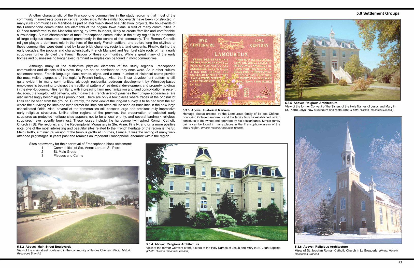
Another characteristic of the Francophone communities in the study region is that most of thecommunity main-streets possess central boulevards. While similar boulevards have been constructed inmany rural communities in Manitoba as part of later 'main-street beautification' projects, the boulevards ofthe Francophone communities are elements of the original town plans, a trait of many communities inQuébec transferred to the Manitoba setting by town founders, likely to create 'familiar and comfortable'surroundings. A third characteristic of most Francophone communities in the study region is the presenceof large religious structures situated prominently in the centre of the community. The Roman Catholicreligion played a dominant role in the lives of the early French settlers, and before long the skylines ofthese communities were dominated by large brick churches, rectories, and convents. Finally, during theearly decades, the popular and characteristically French Mansard and Gambrel style roofs of many earlystructures further denoted the French flavour of these communities. While a great many of the earlyhomes and businesses no longer exist, remnant examples can be found in most communities.
Although many of the distinctive physical elements of the study region’s Francophonecommunities and districts still survive, they are not as dominant as they once were. As in other culturalsettlement areas, French language place names, signs, and a small number of historical cairns providethe most visible signposts of the region's French heritage. Also, the linear development pattern is stillquite evident in many communities, although residential bedroom development by Winnipeg-basedemployees is beginning to disrupt the traditional pattern of residential development and property holdingsin the river-lot communities. Similarly, with increasing farm mechanization and land consolidation in recentdecades, the long-lot field patterns, which gave the French river-lot parishes their unique appearance, arealso increasingly becoming less pronounced. There are only a few places where traces of the original lotlines can be seen from the ground. Currently, the best view of the long-lot survey is to be had from the air,where the surviving lot lines and even former lot lines can often still be seen as tracelines in the now largeconsolidated fields. Also, several of the communities still possess large and architecturally impressiveearly religious structures. Unlike other regions of the province, the preservation of selected earlystructures as protected heritage sites appears not to be a local priority, and several landmark religiousstructures have recently been lost. These losses include the handsome twin-spired Roman CatholicChurch in St. Pierre-Jolys, and the Redemptorist Monastery in Ste. Anne. Finally, and on a more positivenote, one of the most interesting and beautiful sites related to the French heritage of the region is the St.Malo Grotto, a miniature version of the famous grotto at Lourdes, France. It was the setting of many well-attended pilgrimages in years past and remains an important Francophone landmark within the region.
Sites noteworthy for their portrayal of Francophone block settlement:1 Communities of Ste. Anne; Lorette; St. Pierre2 St. Malo Grotto3 Plaques and Cairns
5.0 Settlement Groups
5.3.2 Above: Main Street BoulevardsView of the main street boulevard in the community of Ile des Chênes. (Photo: HistoricResources Branch.)
5.3.5 Above: Relgious ArchitectureView of the former Convent of the Sisters of the Holy Names of Jesus and Mary inSt. Pierre-Jolys, now a Museum and restaurant. (Photo: Historic Resources Branch.)
5.3.6 Above: Religious ArchitectureView of St. Joachim Roman Catholic Church in La Broquerie. (Photo: HistoricResources Branch.)
5.3.4 Above: Religious ArchitectureView of the former Convent of the Sisters of the Holy Names of Jesus and Mary in St. Jean Baptiste(Photo: Historic Resources Branch.)
5.3.3 Above: Historical MarkersHeritage plaque erected by the Lamoureux family of Ile des Chênes,honouring Octave Lamoureux and the family farm he established, whichcontinues to be owned and operated by his descendants. Similar familycairns can be found in many places in the Francophone areas of thestudy region. (Photo: Historic Resources Branch.)

44
5.3.8 Above: Pointe des ChênesDetail of an 1871 map of southern Manitoba, showing survey patterns and landscape features in the area of the 'OakPoint Settlement". Note the two trails leading to the settlement north and south of the Seine River; the 'Great Marsh,just to the west of the settlement; the 'N.W. Angle Road', later named the Dawson Road; and the concentration ofhomes and buildings along the banks of the Seine. (Map Title: Map of the Province of Manitoba Shewing Surveys Effected in1871 and 1872. Source: PAM # H7 614.1 bj 1817 state 1. HRB Map #019.)
5.0 Settlement Groups
5.3.10 Above: Former Redemptorist MonasteryThis impressive structure, originally constructed as a seminary, but used primarilyas a religious retreat and monastery, was demolished in 2001, after preservationinitiative led by local citizens failed to generate sufficient local political support.(Photo: Historic Resources Branch.)
5.3.9 Above: Ste. Anne des Chênes Roman CatholicChurch (Photo: Historic Resources Branch.)
5.3.7 Ste. Anne des ChênesAlthough Ste. Anne wasn't incorporated as a village until 1957, the community was actually
established a century earlier, and is likely the oldest settlement in Manitoba established away from thebanks of the Red and Assiniboine rivers. During the 1850s, Métis families first began constructing homes inthe area near where the Seine River exited the wooded eastern highlands and entered the open Red River'flats', thus providing both pastureland for the livestock and woodlands for building materials and fuel, inaddition to shelter and wild game to help sustain the families during the long and difficult winter months.The first major industry for the community was supplying lumber for the construction of the St. BonifaceCathedral. During the 1870s, Ste. Anne served as a stopover for travellers on their journey to Winnipegalong the famed Dawson Trail. The traditional river-lot land holdings of the settlement were formalized andpreserved in 1881 when the Dominion surveyors staked out 83 long-lot parcels fronting the Seine River.
The Ste. Anne river-lot settlement was initially known as 'Pointe des Chênes' (Oak Point).However, after the St. Boniface Roman Catholic diocese established a parish in the area and named it afterSte. Anne, the settlement and the community slowly took that name. The fact that there was another Métissettlement with the name 'Oak Point', on the southeastern shores of Lake Manitoba, likely played a part inthe renaming of the community from Pointe des Chênes, to Ste. Anne des Chênes. Today the Town isofficially known as Ste. Anne; however Ste. Anne des Chênes is still commonly used. During the 1880s and1890s French-speaking homesteaders from Québec and ex-patriot Québecers from the US easternseaboard arrived in large numbers, solidifying the strong French-Roman Catholic nature of the region. Theeconomic well- being of the settlement was given a great boost at the turn of the century after the CanadianNorthern Railway routed its mainline through the community on its way south of Lake-of-the-Woods toThunder Bay and points east, giving the district daily access to Winnipeg and a market for the district’sdairy and wood products.
5.3.12 Above: Ste. Anne des Chênes, 1922Detail from a 1922 Sectional Map. Note: the railway connection; the roadconfigurations within the settlement; the concentration of development along theriverbank areas; and the community name as Ste. Anne, but the postal name asSte. Anne des Chênes. (Map Title: Sectional Map No. 23, Emerson Sheet, March 1922.Source: Maps & Surveys Branch files. HRB Map #035e)
5.3.11 Above: Ste. Anne des Chênes, c.1870Detail from a painting by H.R. Hind, showing a typical early view ofthe outer parish river-lot settlements in the years prior to theestablishment of the Province of Manitoba. (Source: ProvincialArchives of Manitoba.)

45
5.3.15 Above: Rat River SettlementDetail from a 1921 Sectional Map showing landscape features and survey patterns around the Rat River Settlement. Note thatwithin the settlement the old route of the Crow Wing Trail still serves as the main transportation artery and that PTH #59 has notyet been constructed. Note also the trail crossroads, which gave rise to the community and street plan in St. Pierre.(Map Title: Sectional Map No. 23, Emerson Sheet, March 1922 Source: Maps & Surveys Branch files. HRB Map #035d)
5.0 Settlement Groups5.3.13 St. Pierre-JolysShortly after his participation in the Red River Resistance in 1870, Father Ritchot of Saint-Norbert gathered a small
group of his parishioners together and led an expedition down the Crow Wing Trail to the area near where Joubert Creekjoins with the Rat River. He was convinced that the land there was extremely fertile and a good place for an agriculturalsettlement. As the expedition took place around the Feast Day of Saint-Pierre, the saint's name was chosen for the newsettlement and church. It was Father Ritchot who arranged for the settlement to be surveyed as a river-lot parish settlement.Following the formal creation of a Roman Catholic parish in the area in 1877, those first settlers were joined by several otherMétis families and ex-patriot French Canadians from New England. The word "Jolys" was added to the town's name inhonour of Father Jean-Marie Jolys, the parish's first resident priest, who was responsible for bringing a large third group ofimmigrants to the settlement in 1885. Interestingly, maps of Manitoba produced during the 1880s show the community asbeing called 'Rat River', while many made during the 1890s labeled it simply as “Jolys". Later provincial maps had it as St.Pierre, while most federal maps and locally produced non-government maps tended to use St. Pierre-Jolys. The name mostcommonly used today is simply St. Pierre. Most of the settlement’s early settlers were farmers, while others made cheese,were beekeepers or woodcutters.
Today, the 2,000 residents of this bustling community never miss an opportunity to celebrate their French-Canadianroots and culture. Particularly popular with residents and visitors alike is the fun and sweet taste of the St. Pierre-Jolys maplesyrup festival, held each spring. Like several sister communities in the region, St. Pierre-Jolys boasts a number of interestingheritage buildings, including the former Convent of the Sisters of the Holy Names of Jesus and Mary, now a museum andcultural centre and provincially designated heritage site. The community possesses several unique characteristics whichcelebrate its Francophone roots and culture. These include: a mainstreet boulevard; prominent religious structures; linearrather than grid street patterns; French street names; and several historical cairns and plaques.
5.3.14 Above: Plan of St. Pierre-Jolys in 1966 (Source: Manitoba Highways and Government Services. HRB Map #092a)
46
5.3.17 Left: St. Malo SettlementDetail of a 1918 land ownership map of the St. Malo area, showing thelong-lot configuration within the settlement. Note the triangular-shapedcorner parcels marked 'A' through 'E' which resulted from trying to fitthe riverlots into the township survey system.
(Map Title: Cummins Manitoba Land Map Series Showing Names, Locations &Addresses of Owners, 1918, Sheet 1. PAM # H5 614.3 gbbd Series 41918. HRB Map #008.)
5.0 Settlement Groups
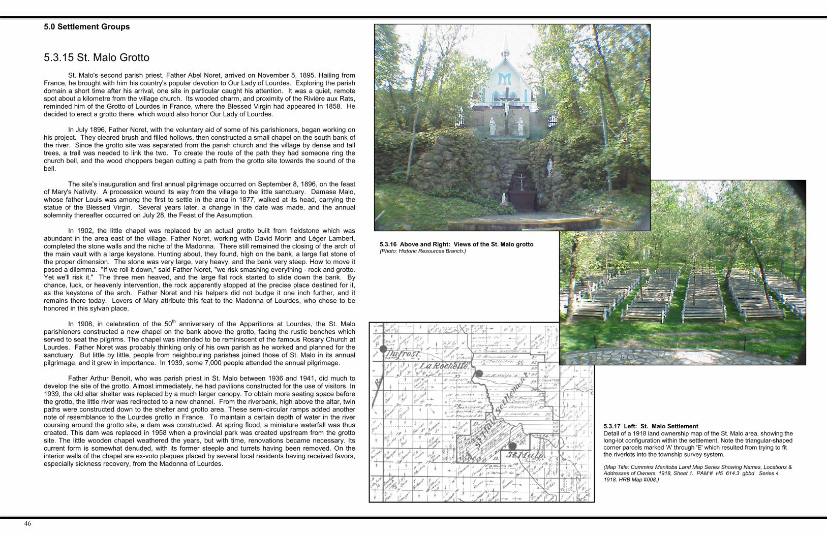
5.3.16 Above and Right: Views of the St. Malo grotto(Photo: Historic Resources Branch.)
5.3.15 St. Malo GrottoSt. Malo's second parish priest, Father Abel Noret, arrived on November 5, 1895. Hailing from
France, he brought with him his country's popular devotion to Our Lady of Lourdes. Exploring the parishdomain a short time after his arrival, one site in particular caught his attention. It was a quiet, remotespot about a kilometre from the village church. Its wooded charm, and proximity of the Rivière aux Rats,reminded him of the Grotto of Lourdes in France, where the Blessed Virgin had appeared in 1858. Hedecided to erect a grotto there, which would also honor Our Lady of Lourdes.
In July 1896, Father Noret, with the voluntary aid of some of his parishioners, began working onhis project. They cleared brush and filled hollows, then constructed a small chapel on the south bank ofthe river. Since the grotto site was separated from the parish church and the village by dense and talltrees, a trail was needed to link the two. To create the route of the path they had someone ring thechurch bell, and the wood choppers began cutting a path from the grotto site towards the sound of thebell.
The site’s inauguration and first annual pilgrimage occurred on September 8, 1896, on the feastof Mary's Nativity. A procession wound its way from the village to the little sanctuary. Damase Malo,whose father Louis was among the first to settle in the area in 1877, walked at its head, carrying thestatue of the Blessed Virgin. Several years later, a change in the date was made, and the annualsolemnity thereafter occurred on July 28, the Feast of the Assumption.
In 1902, the little chapel was replaced by an actual grotto built from fieldstone which wasabundant in the area east of the village. Father Noret, working with David Morin and Léger Lambert,completed the stone walls and the niche of the Madonna. There still remained the closing of the arch ofthe main vault with a large keystone. Hunting about, they found, high on the bank, a large flat stone ofthe proper dimension. The stone was very large, very heavy, and the bank very steep. How to move itposed a dilemma. "If we roll it down," said Father Noret, "we risk smashing everything - rock and grotto.Yet we'll risk it." The three men heaved, and the large flat rock started to slide down the bank. Bychance, luck, or heavenly intervention, the rock apparently stopped at the precise place destined for it,as the keystone of the arch. Father Noret and his helpers did not budge it one inch further, and itremains there today. Lovers of Mary attribute this feat to the Madonna of Lourdes, who chose to behonored in this sylvan place.
In 1908, in celebration of the 50th anniversary of the Apparitions at Lourdes, the St. Maloparishioners constructed a new chapel on the bank above the grotto, facing the rustic benches whichserved to seat the pilgrims. The chapel was intended to be reminiscent of the famous Rosary Church atLourdes. Father Noret was probably thinking only of his own parish as he worked and planned for thesanctuary. But little by little, people from neighbouring parishes joined those of St. Malo in its annualpilgrimage, and it grew in importance. In 1939, some 7,000 people attended the annual pilgrimage.
Father Arthur Benoit, who was parish priest in St. Malo between 1936 and 1941, did much todevelop the site of the grotto. Almost immediately, he had pavilions constructed for the use of visitors. In1939, the old altar shelter was replaced by a much larger canopy. To obtain more seating space beforethe grotto, the little river was redirected to a new channel. From the riverbank, high above the altar, twinpaths were constructed down to the shelter and grotto area. These semi-circular ramps added anothernote of resemblance to the Lourdes grotto in France. To maintain a certain depth of water in the rivercoursing around the grotto site, a dam was constructed. At spring flood, a miniature waterfall was thuscreated. This dam was replaced in 1958 when a provincial park was created upstream from the grottosite. The little wooden chapel weathered the years, but with time, renovations became necessary. Itscurrent form is somewhat denuded, with its former steeple and turrets having been removed. On theinterior walls of the chapel are ex-voto plaques placed by several local residents having received favors,especially sickness recovery, from the Madonna of Lourdes.

47
5.0 Settlement Groups
5.3.19 Below: Oak River ChannelDetail of an 1879 map showing the short remnant section ofthe Oak River waterway (Map Title: Map of Part of Manitoba & theNorth West Territory published to Illustrate the Regulations for theDisposal of Certain Dominion Lands for the Purpose of the CanadianPacific Railway, July 9, 1879. PAM # H3 614.1 gbbd 1879 c.1. HRBMap #003.)
5.3.18 Ile des ChênesThe Ile des Chênes river-lot settlement was established around 1888, and was settled
primarily by Québecios. As in the other 'outer parish' settlements, the settlers broke the land andbegan to raise cattle and crops. Most every spring, however, the area would flood, forcing thesettlers to seek refuge on higher ground. The highest point was a place where oak trees grew inabundance, giving rise to the name Ile des Chênes, or "Island of the Oaks". Because of theannual flooding, the community was moved two miles northwest, outside the actual survey, tohigher and safer ground, as illustrated in the attached maps. Despite the annual flooding, thecommunity continued to grow and by 1905, 358 people lived in the area. In 1908 the ManningCanal was begun, thereby solving the flooding problems. However, the community remained in itsnew location outside the settlement. The river-lot survey itself is rather unusual, as the channel onwhich the lots fronted was a mere five kilometres (three miles) in length and according to mostmaps of the area, begins and ends on the open prairie. As noted earlier, this remnant channelappears to be a section of the Oak River, identified in J.S. Dennis's 1869 map (Figure 1.4.7),which actually only existed as a flowing waterway in times of high water. Nevertheless, this shortchannel was sufficient to serve as a basis for the Ile des Chênes river-lot survey. Currently, thewesterly positions of the channel retain an oak and elm treebelt vegetation zone, and this isbecoming a popular rural residential development area.
5.3.20 Above: Oak River WaterwayThis view shows the portion of thechannel in the area with residentialdevelopment along both sides of theriverbank. (Photo: Historic ResourcesBranch.)
5.3.24 Left: Ile des Chênes,1900Map detail showing thecommunity of "Isle deChene", at the time locatedwithin the river-lot survey.Note the unusual anglicizedspelling of the name, and thatof nearby Lorette, spelled asLoretto in this case. (MapTitle: Map of Government Landsfor Sale, April 18, 1900. Source:PAM H7 614.2 gbbd series 1,1900. HRB Map #039.)
5.3.23 Right: Ile des ChênesMap detail showing the currentlocation of the community of Iledes Chênes, three km NW of theoriginal site. (Map Title: SouthernManitoba 1:500,000, 1991 editionbase map. Source: Manitoba Surveys& Mapping. HRB Map #039.)
5.3.21 Right: Hogue RoadA view of the access road locatedalong the south bank of the Oak RiverChannel remnant showing some of theresidential lot entrances. (Photo: HistoricResources Branch.)
5.3.22 Above: Ile des ChênesTown Plan of the community at its currentlocation along the former Ste. Anne Trail.