5 point questions - west virginia universityddean/ce305/ce305exam... · 2010-04-29 · 5 point...
TRANSCRIPT

1
5 POINT QUESTIONS
1. List three broad types of coordinate systems, provide an example of each, used to locate points on the Earths’ surface and specify the type used in civil engineering applications.
2. Name two common map projection systems used in civil engineering applications and
include the spatial orientation of states where they are used.
3. What are the components of the National Spatial Reference System? What is the advantage of utilizing such a system as the basis for design maps supporting a civil engineering project?
4. What are the geometric entities used to represent geospatial data in a GIS? Provide some
examples of real world features they represent.
5. Describe the difference between a digital orthophoto quad and a topographic map in digital raster graphics (DRG) format.
6. Indentify an in-state source of geospatial data on the web. i.e., a specific web site, where
you would expect to find geospatial data you might use in connection with a civil engineering project. Name a couple of the specific types of data you would find there? Also, identify a specific web site where you would find geospatial data for the entire United States. Again, name a couple of the specific types of data found there applicable to civil engineering projects.
7. Relative to a GIS, describe the following types of data: spatial data, attribute data, and
metadata. Provide an example of each.
8. Random and systematic errors are two types of errors found in surveying measurements. Describe each type of error and explain how they are different in terms of how they propagate in a series of measurements.
9. List three properties of random errors in survey measurements. What is their significance
in terms of checking for gross blunders?
10. Provide a concise definition for each of the following: accuracy, precision, and measurement resolution.
11. Explain the difference between a zenith angle and an angle of elevation and/or an angle
of depression.

2
12. Precision in distance measurements is expressed as a relative error, provided two or more measurements are made of the same line or segment. For example two measurements of the same traverse line are found to be 105.265 and 105.283 feet respectively. Calculate the relative error for this traverse line and express it as a fraction with 1 in the numerator. Provide a narrative to interpret the relative error when it is so expressed.
13. Explain where you might find units of length measurement such as the pole, perch, and
rod. What is the conversion factor for converting each of these units to feet?
14. What is the difference between the international foot and the survey foot? Which one came first?
15. A total station is used to measure the slope distance and slope angle for a traverse line,
they are found to be 421.73 feet and 12˚ 18’ 47” respectively. If the prism or target height and the height of instrument were the same, what are the horizontal distance and the difference in elevation between the ends of this traverse line? Clearly associate your answers with the appropriate parameter.
16. Explain the difference between a mathematically open and a mathematically closed
traverse. Can a geometrically open traverse also be mathematically closed? Explain why or why not.
17. Name the three components of the GPS system
18. Describe conceptually how GPS works.
19. Identify three different types of GPS receivers and provide some idea of the accuracy
obtainable by each.
20. Operationally, there are two broad operational modes when using GPS to determine positions. What are the two modes and provide a statement describing each.

3
21. Match the part number (#) on the sketch to the part name in the list on the right.
Part # PART NAME Vertical Motion
Tangent Screw Leveling Screw Horizontal Motion
Tangent Screw Circular Level Vial Focusing Know
22. From the cross section notes illustrated below, calculate the elevation of points on the cross section at station 1+25
STA BS(+) (ft.) HI (ft.) FS (-) (ft.) Elev. (ft.) Remarks 1+25 3.30 797.62 C/L 5.12 20 ft. L 6.82 40 ft. L 8.51 60 ft. L 7.94 797.62 C/L 6.48 20 ft. R 5.16 4.92 40 ft. R 3.49 60 ft. R 1+25

4
23. Use the data in the following table and compute the missing latitude and departure. Express the latitude and departure to the nearest 0.001 ft.
Sta Azi.
' " Dist. (ft.)
Lat. (ft.)
Dep. (ft.)
3 258°47'39" 155.852 1
24. For the following data, assume that corrections for horizon closure have already been made. Calculate the adjusted interior angle at each station so that corrections are as nearly equal as possible. The closure is a (- 19"). Correction must be in integer seconds only.
Sta. Mean int. CA Adj. int. 1 111°14'31"
2 105°19'24"
3 069°39'52"
4 073°45'54"

5
25. Use the data in the following table and calculate the linear error of closure and relative
error of closure. The relative error of closure must be expressed in the conventional form as a fraction with one in the numerator. Show your work.
Sta Azi.
' " Dist. (ft.)
Lat. (ft.)
Dep. (ft.)
1 060°00'00" 179.354 089.677 155.325 2 183°41'20" 073.163 -073.011 -004.707 3 263°39'42" 151.521 -016.728 -150.595 1 Σ=404.038 Σ = -0.062 Σ =0.023
26. Calculate the area enclosed within the following traverse.
Coordinates (ft.)
Sta. No. North. East. 1 1000.000 1000.000 2 1076.514 933.489 3 968.513 901.190 1 1000.000 1000.000

6
10 POINT QUESTIONS
1. The following sketch of a vertical plane includes the elements used to explain the theory of differential leveling and represents a situation such that the difference in elevation is positive. Match the number on the sketch to the element listed below.
ELEMENT NUMBER
on SKETCH Backsight Backsight Distance Beginning Elevation Datum Difference in Elevation
Ending Elevation Foresight Foresight Distance Height of Instrument Line of sight
7
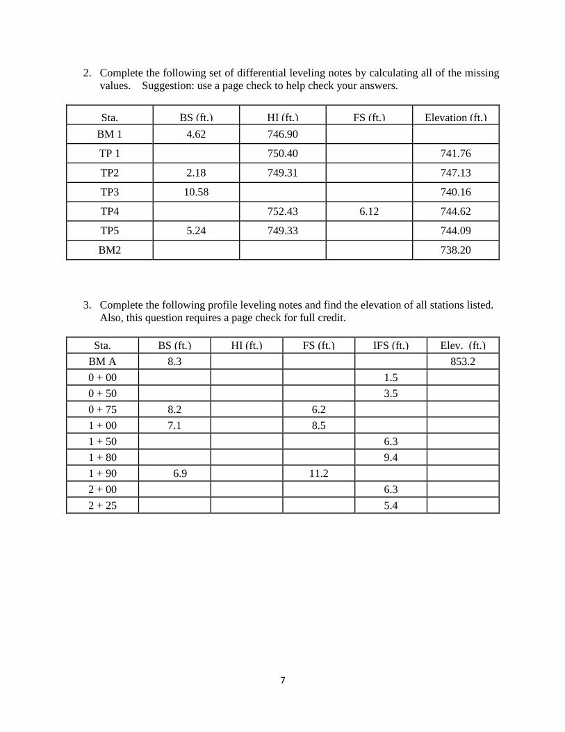
2. Complete the following set of differential leveling notes by calculating all of the missing values. Suggestion: use a page check to help check your answers.
Sta. BS (ft.) HI (ft.) FS (ft.) Elevation (ft.) BM 1 4.62 746.90
TP 1 750.40 741.76
TP2 2.18 749.31 747.13
TP3 10.58 740.16
TP4 752.43 6.12 744.62
TP5 5.24 749.33 744.09
BM2 738.20
3. Complete the following profile leveling notes and find the elevation of all stations listed. Also, this question requires a page check for full credit.
Sta. BS (ft.) HI (ft.) FS (ft.) IFS (ft.) Elev. (ft.)
BM A 8.3 853.2 0 + 00 1.5 0 + 50 3.5 0 + 75 8.2 6.2 1 + 00 7.1 8.5 1 + 50 6.3 1 + 80 9.4 1 + 90 6.9 11.2 2 + 00 6.3 2 + 25 5.4

8
4. Following are the differences in elevation and the distances between bench marks for a closed-loop leveling operation. The closure for this “loop” is +0.08 ft. Assume that the closure is permissible. Answer the question about closure below. Adjust the differences in elevation so that the corrections are proportional to the distance between bench marks. Show checks. Round all calculations to 0.001 ft.
Question: In this situation where no elevations are calculated, what is the numerical value of the fixed or known quantity in the equation for closure?
BM Diff. in elev. (Ft.) Dist. between BMs(ft.)
Corr. (Ft.) (0.001 ft.)
Adj. Diff. in elev. (Ft.) (0.001 ft.)
A
-7.14 600
B
-4.72 1400
C
+11.94 800
A
totals +0.08 2800

9
5. Match the descriptive term from the column on the right with the angle or direction, identified as A through J from the following sketch. It is possible for a term or angle to be used more than once. Also, it is possible for a term or angle listed on the right to not be used at all.
Angle Designated on Sketch
Term for Angle or Direction
A 1. Left Deflection Angle
B 2. Interior Angle
C 3. Complementary to Azimuth
D 4. Azimuth from South
E 5. Explementary to Bearing
F 6. Angle Closure
G 7. Azimuth from North
H 8. Magnetic Declination
I 9. Angle-to-the-Right
J 10. Right Deflection Angle
11. Bearing Angle
12. Bearing Angle Complement

10
6. On the following sketch, the azimuth from north for line 1-2 is 312 45'25" and the
deflection angle at Station #2 is 76 50'30" L, what are the directions and angles as requested below?
Angle or Direction Value Interior Angle at Station #2
Azimuth from North for line 2-3
Angle-to-the-Right at Station #2
Bearing of line 3-2
Azimuth from south for line 2-1

11
7. Use the data in the following table to calculate the missing corrections to latitudes and departures and the missing balanced latitudes and departures.
Sta Azi.
' " Dist. (ft.)
Lat. (ft.)
Dep. (ft.)
Corr. Bal. Lat.
Bal. Dep. Lat. Dep.
1 10°00'00" 121.922 120.070 21.172 2 108°46'57" 105.156 -33.858 99.556 3 234°29'04" 148.290 -86.145 -120.702 -0.026 -0.011 -86.171 -120.713 1 Σ=375.368 Σ=0.067 Σ=0.026
8. Perform the inverse problem to find the azimuth (in degrees, minutes, seconds) and distance (0.001 ft.) between the traverse stations identified in the following table.
Coordinates (ft.)
Sta. No. North. East. AZIMUTH
( ˚ ‘ “) DIST
(0.001 ft.) 1 1000.000 1000.000
2 1020.434 1122.154
3 920.081 1054.755
1 1000.000 1000.000

12
9. The coordinates, deflection angle, and station number at a PI are as follows:
Northing = 5000.0000 Easting = 5000.0000 ∆ = 30˚ 00’ R PI Station number = 55 + 00.00 The station number for the PC is 52+44.13 The direction of the back tangent from the PC to the PI is N 62˚30’ E. A degree of curve equal to 6˚00’ (i.e., Da = 6˚00’) will connect the two tangents at this PI. A utility line intersects the curve at Station = 53+50.00 What are the coordinates (0.001 ft.) of this intersection point? What is the station number of PT for this curve?
10. A -4.00% (g1) grade meets a +6.00% (g2) grade at station 41+00 and the elevation of this PIVC is 800.00 feet. A 600-foot parabolic vertical curve will be constructed to connect to two vertical grades. The station and grade elevation of the turning point (low point on the curve) is needed in order to know where to place a storm drain inlet on this roadway alignment. What is the station number and grade elevation of the turning point?