5-day training course on “flood mitigation” courses/flood mitigation 1… · 5-day training...
TRANSCRIPT
1
5-Day Training CourseOn
“Flood Mitigation”
Title: Pakistan Indus River System
On: February 15, 2010
At I l b d At: Islamabad
Organized By: NDMA-UNDP
Sequence of Lecture
Physiography and Land use;
Pakistan’s River System;
Indus River Basin – Salient Features;
Salient features & catchments of main rivers (Sutlej, Ravi, Chenab, Jhelum, Indus);(Sutlej, Ravi, Chenab, Jhelum, Indus);
Indus River System-Replacement works and Indus Basin Irrigation System
2
DISPUTED
TERRITORY
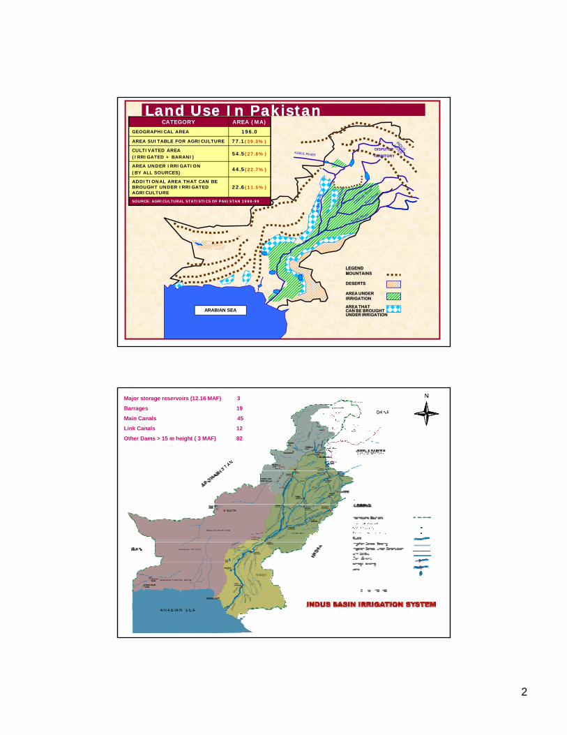
CATEGORY AREA (MA)
GEOGRAPHICAL AREA 196.0
AREA SUITABLE FOR AGRICULTURE 77.1(39.3%)
CULTIVATED AREA(IRRIGATED + BARANI)
54.5(27.8%)
AREA UNDER IRRIGATION(BY ALL SOURCES)
44.5(22.7%)
ADDITIONAL AREA THAT CAN BE
Land Use In PakistanLand Use In Pakistan
ADDITIONAL AREA THAT CAN BE BROUGHT UNDER IRRIGATED AGRICULTURE
22.6(11.5%)
SOURCE: AGRICULTURAL STATISTICS OF PAKISTAN 1998-99
ARABIAN SEA
LEGENDMOUNTAINS
DESERTS
AREA UNDERIRRIGATION
AREA THATCAN BE BROUGHTUNDER IRRIGATION
Major storage reservoirs (12.16 MAF) 3
Barrages 19
Main Canals 45
Link Canals 12
Other Dams > 15 m height ( 3 MAF) 82
3
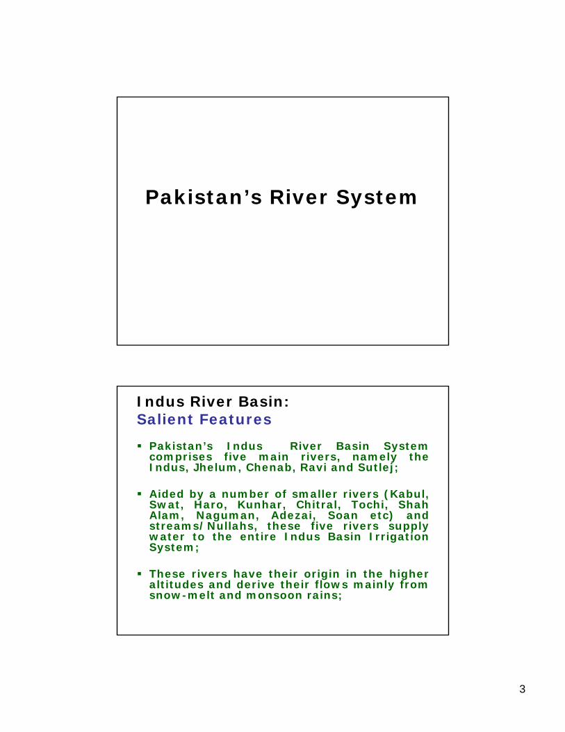
Pakistan’s River System
Indus River Basin:Salient Features
Pakistan’s Indus River Basin Systemcomprises five main rivers, namely theIndus Jhelum Chenab Ravi and Sutlej;Indus, Jhelum, Chenab, Ravi and Sutlej;
Aided by a number of smaller rivers (Kabul,Swat, Haro, Kunhar, Chitral, Tochi, ShahAlam, Naguman, Adezai, Soan etc) andstreams/Nullahs, these five rivers supplywater to the entire Indus Basin IrrigationSystem;y ;
These rivers have their origin in the higheraltitudes and derive their flows mainly fromsnow-melt and monsoon rains;
4
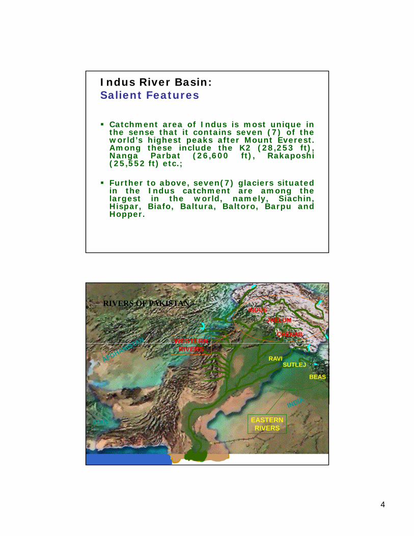
Indus River Basin:Salient Features
Catchment area of Indus is most unique inthe sense that it contains seven (7) of thethe sense that it contains seven (7) of theworld’s highest peaks after Mount Everest.Among these include the K2 (28,253 ft),Nanga Parbat (26,600 ft), Rakaposhi(25,552 ft) etc.;
Further to above, seven(7) glaciers situatedin the Indus catchment are among thein the Indus catchment are among thelargest in the world, namely, Siachin,Hispar, Biafo, Baltura, Baltoro, Barpu andHopper.
RIVERS OF PAKISTANINDUS
JHELUM
CHENABWESTERN
RAVISUTLEJ
BEAS
RIVERS
EASTERN RIVERS
IRAN
5
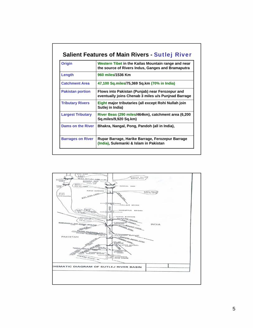
Salient Features of Main Rivers - Sutlej RiverOrigin Western Tibet in the Kailas Mountain range and near
the source of Rivers Indus, Ganges and Bramaputra
Length 960 miles/1536 Km
Catchment Area 47,100 Sq.miles/75,369 Sq.km (70% in India)
Pakistan portion Flows into Pakistan (Punjab) near Ferozepur and eventually joins Chenab 3 miles u/s Punjnad Barrage
Tributary Rivers Eight major tributaries (all except Rohi Nullah join Sutlej in India)
Largest Tributary River Beas (290 miles/464km), catchment area (6,200 S il /9 920 S k )Sq.miles/9,920 Sq.km)
Dams on the River Bhakra, Nangal, Pong, Pandoh (all in India),
Barrages on River Rupar Barrage, Harike Barrage, Ferozepur Barrage (India), Sulemanki & Islam in Pakistan
6
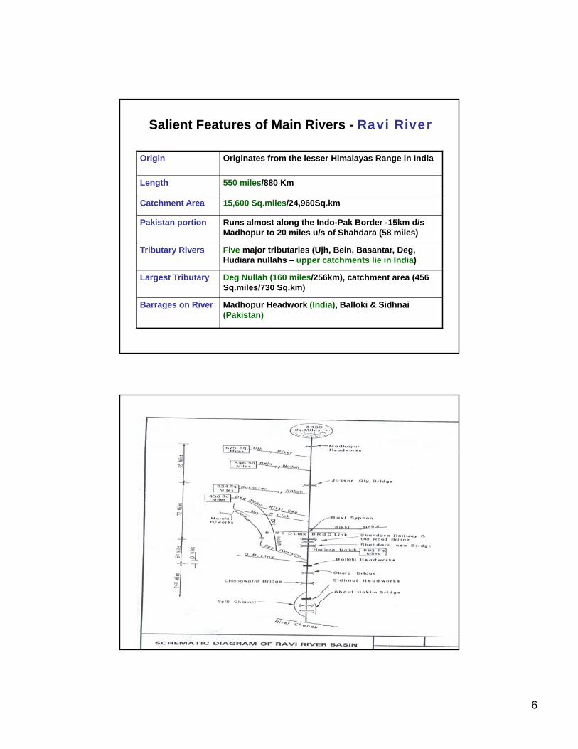
Salient Features of Main Rivers - Ravi River
Origin Originates from the lesser Himalayas Range in India
Length 550 miles/880 KmLength 550 miles/880 Km
Catchment Area 15,600 Sq.miles/24,960Sq.km
Pakistan portion Runs almost along the Indo-Pak Border -15km d/s Madhopur to 20 miles u/s of Shahdara (58 miles)
Tributary Rivers Five major tributaries (Ujh, Bein, Basantar, Deg, Hudiara nullahs – upper catchments lie in India)
Largest Tributary Deg Nullah (160 miles/256km), catchment area (456 Sq.miles/730 Sq.km)
Barrages on River Madhopur Headwork (India), Balloki & Sidhnai (Pakistan)
7
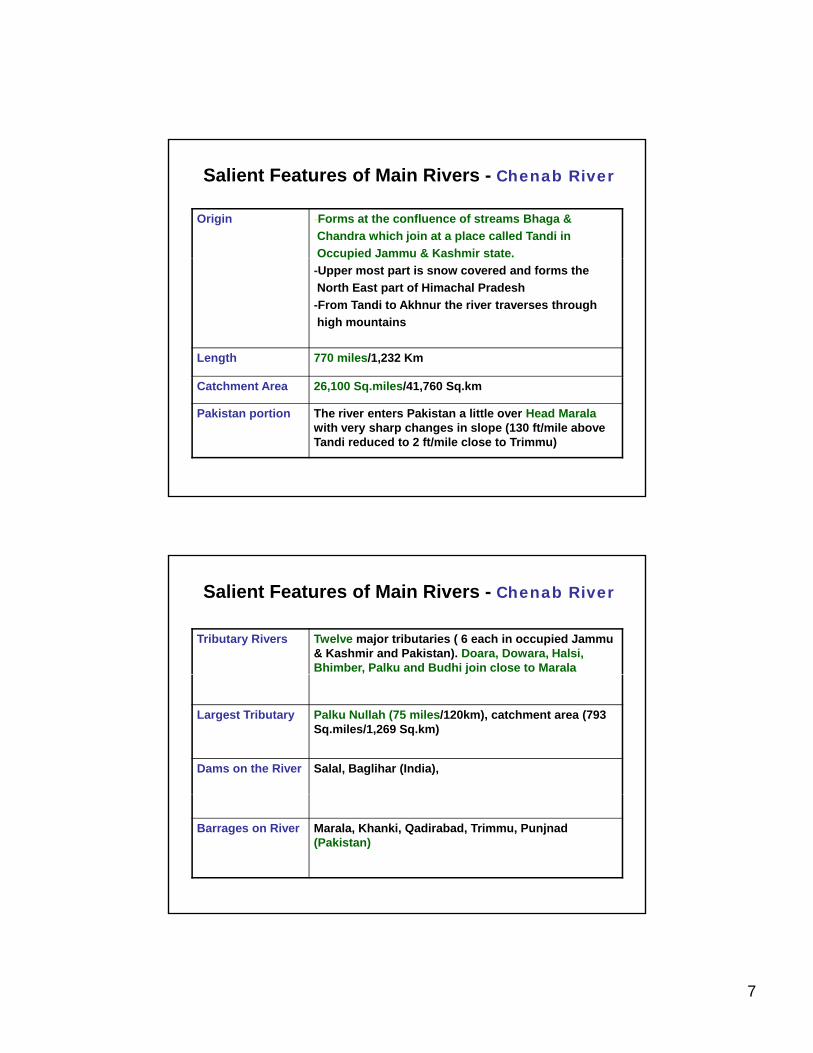
Salient Features of Main Rivers - Chenab River
Origin -Forms at the confluence of streams Bhaga & Chandra which join at a place called Tandi in Occupied Jammu & Kashmir state.p-Upper most part is snow covered and forms the North East part of Himachal Pradesh-From Tandi to Akhnur the river traverses through high mountains
Length 770 miles/1,232 Km
Catchment Area 26,100 Sq.miles/41,760 Sq.km
Pakistan portion The river enters Pakistan a little over Head Maralawith very sharp changes in slope (130 ft/mile above Tandi reduced to 2 ft/mile close to Trimmu)
Salient Features of Main Rivers - Chenab River
Tributary Rivers Twelve major tributaries ( 6 each in occupied Jammu & Kashmir and Pakistan). Doara, Dowara, Halsi, Bhimber, Palku and Budhi join close to Marala
Largest Tributary Palku Nullah (75 miles/120km), catchment area (793 Sq.miles/1,269 Sq.km)
Dams on the River Salal, Baglihar (India),
Barrages on River Marala, Khanki, Qadirabad, Trimmu, Punjnad (Pakistan)
8
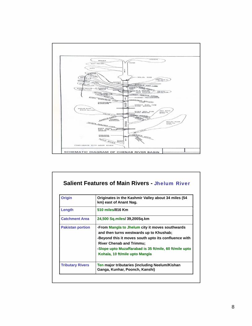
Salient Features of Main Rivers - Jhelum River
Origin Originates in the Kashmir Valley about 34 miles (54 km) east of Anant Nag.
L th 510 il /816 KLength 510 miles/816 Km
Catchment Area 24,500 Sq.miles/ 39,200Sq.km
Pakistan portion -From Mangla to Jhelum city it moves southwards and then turns westwards up to Khushab;-Beyond this it moves south upto its confluence with River Chenab and Trimmu;-Slope upto Muzaffarabad is 35 ft/mile, 60 ft/mile upto Kohala, 10 ft/mile upto Mangla
Tributary Rivers Ten major tributaries (including Neelum/Kishan Ganga, Kunhar, Poonch, Kanshi)
9
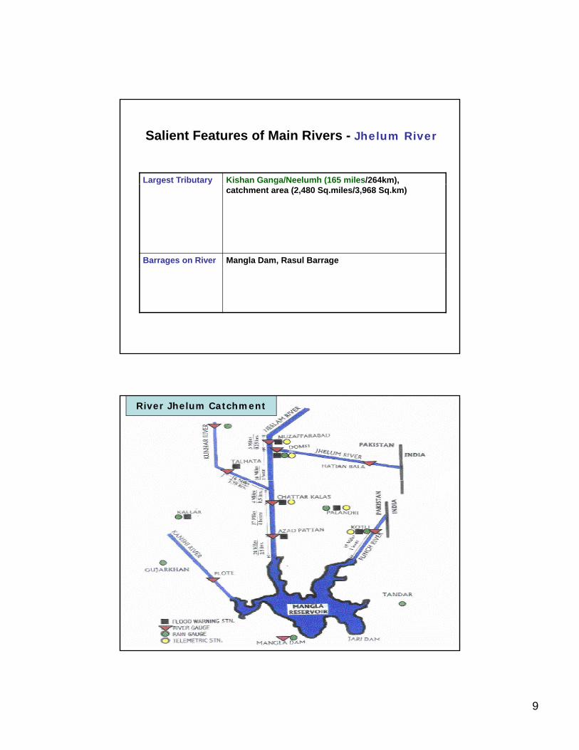
Salient Features of Main Rivers - Jhelum River
Largest Tributary Kishan Ganga/Neelumh (165 miles/264km), g y g ( ),catchment area (2,480 Sq.miles/3,968 Sq.km)
Barrages on River Mangla Dam, Rasul Barrage
River Jhelum Catchment
10
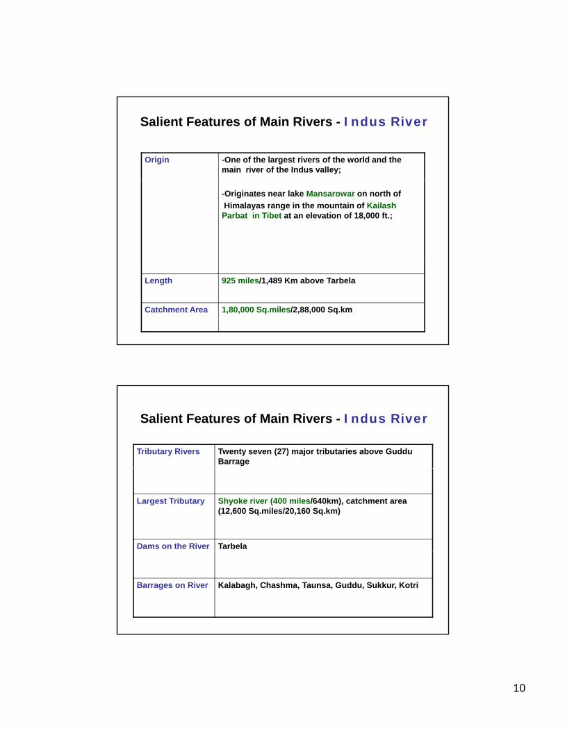
Salient Features of Main Rivers - Indus River
Origin -One of the largest rivers of the world and the main river of the Indus valley;
-Originates near lake Mansarowar on north of Himalayas range in the mountain of Kailash Parbat in Tibet at an elevation of 18,000 ft.;
Length 925 miles/1,489 Km above Tarbela
Catchment Area 1,80,000 Sq.miles/2,88,000 Sq.km
Salient Features of Main Rivers - Indus River
Tributary Rivers Twenty seven (27) major tributaries above Guddu Barrage
Largest Tributary Shyoke river (400 miles/640km), catchment area (12,600 Sq.miles/20,160 Sq.km)
Dams on the River Tarbela
Barrages on River Kalabagh, Chashma, Taunsa, Guddu, Sukkur, Kotri
11
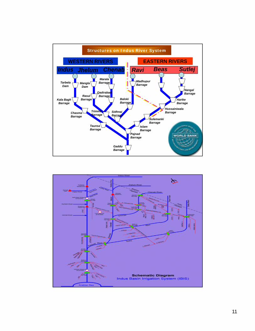
WESTERN RIVERS EASTERN RIVERSIndus Jhelum Chenab Ravi Beas Sutlej
Marala Madhupur
Structures on Indus River System
Kala Bagh Barrage
Chasma Barrage
Mangla Dam
Rasul Barrage
Trimmu Barrage
Sidhnai Barrage
Qadirabad Barrage
Barrage
Baloki Barrage
Madhupur Barrage
Sulemanki
Hussainiwala Barrage
Harike Barrage
Nangal Barrage
Tarbela Dam
Taunsa Barrage
Gaddu Barrage
Pajnad Barrage
Islam Barrage
Sulemanki Barrage
12
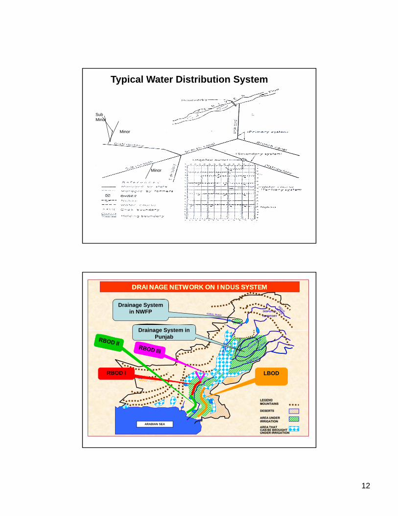
Typical Water Distribution System
Sub Minor
Minor
Minor
DISPUTED
TERRITORY
DRAINAGE NETWORK ON INDUS SYSTEMDRAINAGE NETWORK ON INDUS SYSTEM
Drainage System in NWFP
Drainage System in
RBOD I LBOD
Drainage System in Punjab
ARABIAN SEA
LEGENDMOUNTAINS
DESERTS
AREA UNDERIRRIGATION
AREA THATCAN BE BROUGHTUNDER IRRIGATION

13
End of Presentation
Thank You