4.seismic activity in the western extension …. seismic activity in the...seismic activity in the...
TRANSCRIPT

Pakistan Journal of Meteorology Vol. 2: Issue 3: (March 2005)
35
SEISMIC ACTIVITY IN THE WESTERN EXTENSION OF SALT RANGE Azam A. Khwaja∗ & MonaLisa
Abstract: In the present work, an attempt has been made to study in detail the seismicity of the Surghar, Marwat, Khisor, Pezu and Manzai Ranges, which are known as the western extension of the Salt Range. For this purpose all available earthquake data with magnitude ≥ 3.0 mb from both international seismological networks as well as the local seismic observatories has been collected and seismicity map of the area has been prepared for the period of 1904-2002. Based upon this seismicity map, the study area appears to be more active as compared to the adjacent regions of the Bannu Basin and the Punjab plains. The seismicity is mostly concentrated along the Surghar Thrust, Pezu Fault and the Kurram Thrust. A total of nine focal mechanism solutions of seismic events have been determined. Out of these nine, four are reverse/thrust; three are strike slip while two are normal, which confirms the dominance of reverse/thrusting over the strike slip from this part of the NW Himalayan Fold-and-Thrust Belt, Pakistan.
Introduction: The study area forms part of the NW Himalayan Fold and Thrust Belt, which is seismically very active. A number of workers (e.g. Verma, 1991; Sercombe et al., 1998; MonaLisa et al., 2002; Khwaja et al., 2003; MonaLisa et al., 2004) have attributed towards the seismicity/tectonics of this one of the seismically active regions of the world to highlight and understand the ongoing collisional process of the Indo-Pakistan plate with the Kohistan Island Arc. Besides the N-S compression, as a result of this convergence, the above-mentioned workers have also recognized transpressional features. However, in the study area not only the dominance of reverse/thrusting over the strike slip faulting have been recognized but also the presence of normal component has also been found. Thus, in the present study the nature of fault motions prevailing at depth within the western extension of Salt Range are described. Such type of information, it is hoped would lead to incorporation of seismicity data in future models.
Geology of the Area: The active fold – and – thrust belt along the northwestern margin of the Indo – Pakistan plate is divisible into two parts i.e. the Sulaiman belt and the NW Himalayan fold and thrust belt. The former is believed to be along a zone of transpression, whereas the latter is associated with the main zone of Himalayan convergence (Jadoon, 1992).
∗ Department of Earth Sciences, Quaid-i-Azam University Islamabad, Pakistan

Pakistan Journal of Meteorology Vol. 2: Issue 3: (March 2005)
36
Transpression is considered to be result of the 80 to 900 km long Chaman and Ornach – Nal Fault Zones (Lawrence and Yeats, 1979) and forms the western plate boundary. In the Himalayan zone of convergence (Fig.1), the Main Karakoram Thrust (MKT) also known as the Shyok Suture Zone; Main Mantle Thrust (MMT) also known as the Indus Suture Zone; Main Boundary Thrust (MBT) and the Salt Range Thrust (SRT) delineate the major subdivisions of the collision zone (Yeats and Lawrence, 1984; Tahirkheli et al., 1979).
The study area represents the western extension of the Salt Range. Geologically it forms part of the foreland zone of the NW Himalayan Fold and Thrust belt. This foreland zone comprising of Salt Range, Potwar plateau/Kohat plateau and Hazara ranges is an area bounded by the Salt Range Thrust in the south and the Panjal-Khairabad Fault in the north (Fig.1). At its eastern end is the nearly N–S running left lateral Jhelum Fault (Kazmi and Jan, 1997). The western extension of Salt Range, also known as the Trans-Indus Ranges, comprises of the Surghar, Marwat, Khisor, Pezu and Manzai Ranges, which form an “S” shaped double re-entrant and surround the Bannu Basin (Fig.2). The Surghar and Khisor Ranges are asymmetrical and overfolded anticlines. The Marwat Range is also an anticlinal feature, largely covered by the Siwaliks. Late Permian to Cretaceous rocks are exposed near its southwestern end are unconformably overlain by the Siwaliks. The Bhittani and Manzai Ranges are also anticlinal and are entirely covered by the Siwaliks. The Bhittani anticline has been found to be faulted. A north dipping thrust, the Surghar Thrust is located along the southern margin of the Surghar Range. It is probably the western extension of the SRT and continues along the southern/eastern margin of the Trans-Indus Ranges (Gee, 1989). As compared to the adjacent Bannu basin, the area appeared to be seismically more active (Fig.2) and there is a good evidence of ongoing thrust faulting at the base of the Khisor Range. The short term-teleseismic data from the Tarbela Network shows that the Trans-Indus Range is an active tectonic feature.
Focal Mechanism Studies: In the present case, for the determination of focal mechanism solutions, the earthquakes reported by USGS, ISC and the local networks with magnitudes near 4.0 and above occurring in the area during the period of 1964-2002 were considered. Nine focal mechanism solutions (Fig.2 and Tables 1&2) were determined from the P-wave first motion directions. The parameters for the epicenters and the focal mechanism solutions of all the nine earthquakes are listed in Tables 1&2.
The standard lower half hemisphere projections on an equal area net have been used. Visual interpretation of these focal mechanism diagrams generated with the help of a computer program PMAN (Suetsugu, 1996) that required input of geographic coordinates, magnitude, focal depth and P wave polarity was carried out for each event. The other two parameters azimuthal angle and take-off angle are determined by the software AZMTAK (Suetsugu, 1996). From the large number of events shown in Fig.2, the above-mentioned parameters were available only for the nine events discussed in this study.

Pakistan Journal of Meteorology Vol. 2: Issue 3: (March 2005)
37
Event No.1: is located in the west of Kurram thrust (Fig.2). A pure thrust solution has been obtained for this event (Fig.3). NE-SW trending and NW dipping nodal plane is selected as the rupture plane taking into consideration of the trend and dip direction of the Kurram Thrust.
Event No.2: This event is lying too in between a thrust and an anticline (Fig.2). But the solution obtained for this event is of pure thrusting (Fig.3), which is in correspondence with those of the structures present in the area. Taking into consideration of the general trend of the nearby thrust, the NW dipping nodal plane trending in the NE-SW direction is selected as the rupture plane.
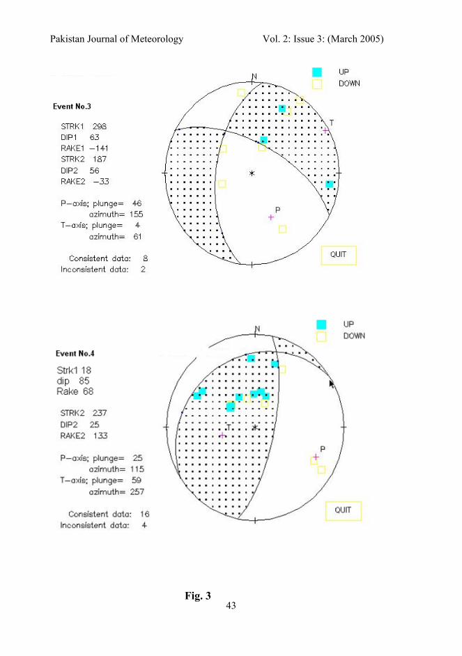
Event No.3: Like event no.1 this event is located in the west of the Kurram Thrust (Fig.2). The solution obtained for this earthquake is of normal faulting, again not matching with the mapped structures. However, based upon the trend (i.e. NE-SW) and dip (i.e. NW), the NW dipping nodal plane and trending in the NE-SW direction is considered to be the rupture plane (Fig.3).
Event No.4: is located at the distance of about 6 km NW of the event no.2 (Fig.2). A pure thrust solution has been obtained for this event (Fig.3). NE-SW trending and NW dipping Kurram Thrust is passing in the NW of this event. Therefore, NW dipping nodal plane with NE-SW direction is taken as the rupture plane.
Event No.5: is located in the SW of event no.2 (Fig.2). The solution obtained is of right lateral strike slip faulting (Fig.3). The nodal plane trending in the NE-SW direction and dipping in the NW direction is considered as the rupture plane.
Event No.6: is situated in the SSW of the Bhittani thrust (Fig.2). The solution obtained is of right lateral strike slip (Fig.3). The nodal plane trending in the NNW-SSE direction with the right lateral sense of motion is selected as the rupture plane as its trend (NNW-SSE) and nature (right lateral strike slip) matches with the Pezu Fault.
Event No.7: This event is located in between a thrust (no name has been given to this thrust yet) and an anticline (Fig.2). Contrary to the general structural nature of the area i.e. the thrusting (reverse) and strike slip, the solution obtained is of normal faulting (Fig.3). Also both of the nodal planes are trending in the ESE-WNW and ENE-WSW direction, which is not following the general trend of the mapped structural features, which is NE-SW or NW-SE. However, on the basis of the dip direction of the thrust mapped at the nearby place (Fig.2), the nodal plane trending in the ESE-WNW is considered as the rupture plane.
Event No.8: The Marwat Thrust, Bhittani Thrust and the right lateral strike slip Pezu Fault are the structural features situated in the SE, SW and south of the location of this event respectively (Fig.2). The solution obtained for this event is of Thrust with some right lateral strike slip component (Fig.3), which is in correspondence to the local structure of the area mentioned above. The nodal plane trending in the NNE-SSW direction is considered to be the rupture plane as its trend matches with that of the Pezu fault.

Pakistan Journal of Meteorology Vol. 2: Issue 3: (March 2005)
38
Event No.9: is situated in the south of the Khisor Thrust (Fig.2). Seeber and Armbruster, 1979 referred this area as the Punjab Seismic Zone (PSZ). The solution obtained for this event is of strike slip with normal component (Fig.3). The normal component may be due to some local feature, which may be activated due to Sargodha high pushing. Thus taking into consideration the general structural trend of the area, the NE-SW trending nodal plane is selected as the fault plane.
Summary and Conclusions: Based upon the seismicity data, the study area is found to be representing moderate seismic activity. The seismicity is mostly concentrated along the Surghar Thrust, Pezu Fault and the Kurram Thrust. A total of nine focal mechanism solutions have been determined. Out of these nine, four are reverse/thrust; three are normal while only two are strike slip, which shows the dominance of reverse/thrusting over the strike slip from this part of the NW Himalayan Fold-and-Thrust Belt, Pakistan. P-axes and T-axes, however, show mixed trend i.e. both NE-SW and NW-SE directions. This shows that energy is accumulated and released from these directions. Since most of the depth data has been taken from the local seismological networks therefore the depth estimations for the events is reliable.
References: Gee, E.R., 1989. Overview of the geology and structure of the Salt Range, with observations on related areas of northern Pakistan. In: Malinconico, L.L. & Lillie, R.J. (eds.). Tectonics of the western Himalayas. Geol. Soc., Spec. Pap. 232. Pp. 95-112.
Jadoon, I. A. K., 1992. Thin-skinned tectonics on continent/ocean transitional crust, Sulaiman Range, Pakistan. (Unpubl.) Ph.D. thesis. Geology Dept. Oregon State Univ, USA.
Kazmi, A. H., and Jan. M. Q., 1997. Geology and Tectonics of Pakistan. Graphic Publishers Karachi – Pakistan. Pp. 139.
Khwaja, A.A., MonaLisa., Khan, S.A., Chaudhry., Rafiq,M & Khan, A.T., 2003. Recent Seismic Activity along the western margin of the Nanga Parbat Haramosh Massif, Pakistan. Islamabad Jour. Of Science. v.13 (1). Pp. 18-27.
Lawrence, R.D. and Yeats, R.S., 1979, Geological reconnaissance of the Chaman Fault in Pakistan. In: Farah, A. & DeJong, K.A. (eds.). Geodynamics of Pakistan. Geol.Surv.Pak. Quetta, Pp. 351-357.
MonaLisa, Khwaja, A. A. and Qaiser, M., 2002. Focal Mechanism Studies of Kohat and Northern Potwar Deformed Zone. Geological Bulletin, University of Peshawar, Vol.35. Pp. 85-95.
MonaLisa, Shahid A. Khan and Azam A. Khwaja, (2004). Focal Mechanism Studies of North Potwar Deformed Zone (NPDZ), Pakistan. Acta Seismologica Sinica, China. Vol.17 No.3. Pp. 255-261.

Pakistan Journal of Meteorology Vol. 2: Issue 3: (March 2005)
39
Sercombe, W.J., Pivnik, D.A., Wilson, W.P., Albertin, M.L., Beck, R.A. and Stratton, M.A., 1998, Wrench Faulting in the northern Pakistan foreland. AAPG Bulletin, v. 82, Pp. 2003 –2030.
Suetsugu, D., 1996. Source Mechanism Practice. In: Training Course in Seismology and Earthquake Engineering II. Japan Int. Cooperation Agency (JICA), Ibaraki-ken 305 Japan.p.13-48.
Tahirkheli, R.A.K., Mattauer, M., Proust, F. and Tapponier, P., 1979. The India-Eurasia suture zone in northern Pakistan: Some new data for interpretation at plate scale. In: Farah, A. & DeJong, K.A.,(eds.).Geodynamics of Pakistn. Geol. Surv. Pak., Quetta, 125-130.
Verma, R.K., 1991. Seismicity of the Himalaya and the Northeast India, and nature of continent-continent collision. In: Sharma, K.K., (eds.). Geology and Geodynamic evolution of the Himalayan collision zone, Part 2, Physics and Chemistry of the earth. Pergamon press, Oxford, Pp. 345-370.
List of Figures and Tables Fig.1: Regional Tectonic Map of Northwest Himalayas of Pakistan
Fig.2: Seismicity and structural map of the study area where 1,2,3 etc represents the location of the earthquakes whose Focal Mechanism Solution (FMS) have been carried out.
Fig.3: Focal Mechanism Solutions of all 9 events. Here up means compressions and down means dilatations.
Table.1: Source parameters of the earthquakes used in the present study.
Table.2: Parameters obtained from Focal Mechanism Studies

Pakistan Journal of Meteorology Vol. 2: Issue 3: (March 2005)
40
Fig.1

Pakistan Journal of Meteorology Vol. 2: Issue 3: (March 2005)
41
Fig. 2

Pakistan Journal of Meteorology Vol. 2: Issue 3: (March 2005)
42
Fig. 3
Pakistan Journal of Meteorology Vol. 2: Issue 3: (March 2005)
43
Fig. 3

Pakistan Journal of Meteorology Vol. 2: Issue 3: (March 2005)
44
Fig. 3

Pakistan Journal of Meteorology Vol. 2: Issue 3: (March 2005)
45
Fig. 3

Pakistan Journal of Meteorology Vol. 2: Issue 3: (March 2005)
46
Fig. 3

Pakistan Journal of Meteorology Vol. 2: Issue 3: (March 2005)
47
Table 1
Solution Nos.
Date
D/M/Y Time
H: M: S
Latitude
(N)
Longitude
(E)
Depth
(Kms) Magnitude
1 20/01/67 9:31:21 34.71 72.36 47 5.5 Mb 2 26/07/68 20:48:05 32.23 70.19 50 4.2 Mb 3 7/4/74 16:07:47 32.34 69.89 46 4.8 Mb 4 28/05/82 0:58:48 32.36 70.09 18.0 5.0 ML 5 4/1/92 3:35:21 32 70 7.0 5.8 ML 6 1/10/96 16:14:30 32.24 70.53 1.7 4.6 ML 7 23/01/99 9:53:00 32.27 70.2 14.6 5.5 ML 8 16/4/99 22:11:00 32.49 70.8 10 4.8 ML 9 9/11/99 23:59:00 32.09 71.41 4.1 5.0 ML
Table 2
Fault Plane (FP) Auxiliary Plane (AP) P-Axis T-Axis FPS No.
Nature of Fault Plane
Solution (FPS)
Strike Dip Strike Dip Strike Plunge Strike Plunge
1 THRUST 320 400NW 2200 510SE -540 60 1630 830
2 THRUST 2530 200NW 350 740 SE 1350 280 2880 590
3 NORMAL 1870 560 W 2980 630 E 1550 460 610 40
4 THRUST 2370 250NW 180 850 SE 1150 250 2570 590
5 RLSS 2000 870NW 2910 700NE 2480 120 1540 160
6 RLSS 3500 660 E 850 790 S 2150 90 3090 250
7 NORMAL 2810 350 N 560 640 SE 2860 630 1630 150
8 THRUST 1830 670 W 3030 410NE 2480 150 1370 550
9 LSS 350 860SE 1310 340SW 3360 390 970 330