4.2.4 transportation, accommodation and communication
TRANSCRIPT
�5
government reserves and vast stretches of
unoccupied high-country Crown lands in
Amuri District attracted them in droves (Gardner
1956). In 1892, runholders south of the Hurunui
built another fence along that river (Scotter
1965). The Rutherfords and other runholders
ring-fenced their land (Scotter 1965). However,
rabbit-proof fences were expensive and difficult
to repair, and the rabbits had usually already
infested an area that runholders or rabbit
boards had decided was to be cordoned off
(Nightingale 1992).
In Canterbury, methods of containment and
destruction were thought to be keeping the
brown rabbits under control. Silver grey rabbits
from the north and wild rabbits from Otago
were more invasive (Scotter 1965). A rabbit-
proof fence, which stretched for 40 miles
(c. 64 km) down the Tasman Valley from the
Mueller Glacier and another 40 miles across to
Hakataramea, was built by 1888 (Scotter 1965).
Although rabbit-proof fences previously erected
in Otago had not been successful (Scotter 1965),
this one was stronger, had traps attached to it
and was inspected each day. It worked, but
rabbits on the other side multiplied. In 1892,
over 40 000 rabbits were killed between the
Tekapo and Pukaki Rivers (Scotter 1965).
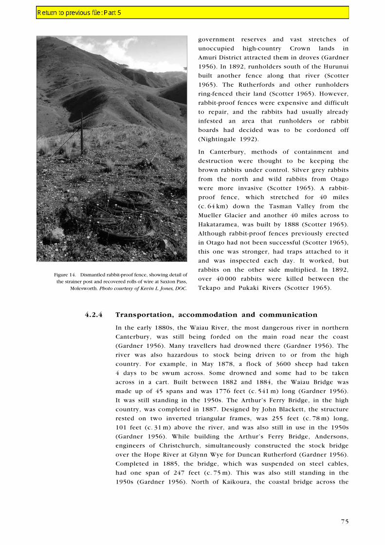
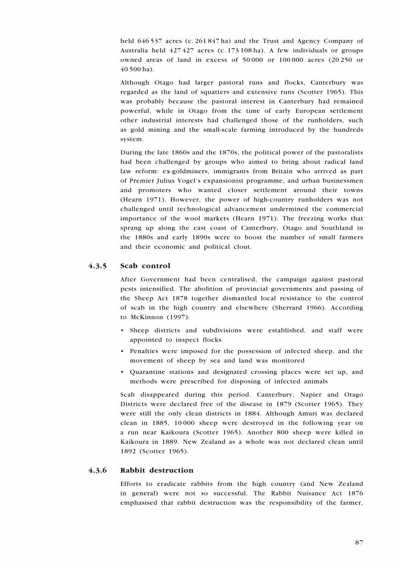
Figure 14. Dismantled rabbit-proof fence, showing detail of the strainer post and recovered rolls of wire at Saxton Pass,
Molesworth. Photo courtesy of Kevin L. Jones, DOC.
4.2.4 Transportation, accommodation and communication
In the early 1880s, the Waiau River, the most dangerous river in northern
Canterbury, was still being forded on the main road near the coast
(Gardner 1956). Many travellers had drowned there (Gardner 1956). The
river was also hazardous to stock being driven to or from the high
country. For example, in May 1878, a flock of 3600 sheep had taken
4 days to be swum across. Some drowned and some had to be taken
across in a cart. Built between 1882 and 1884, the Waiau Bridge was
made up of 45 spans and was 1776 feet (c. 541 m) long (Gardner 1956).
It was still standing in the 1950s. The Arthur’s Ferry Bridge, in the high
country, was completed in 1887. Designed by John Blackett, the structure
rested on two inverted triangular frames, was 255 feet (c. 78 m) long,
101 feet (c. 31 m) above the river, and was also still in use in the 1950s
(Gardner 1956). While building the Arthur’s Ferry Bridge, Andersons,
engineers of Christchurch, simultaneously constructed the stock bridge
over the Hope River at Glynn Wye for Duncan Rutherford (Gardner 1956).
Completed in 1885, the bridge, which was suspended on steel cables,
had one span of 247 feet (c. 75 m). This was also still standing in the
1950s (Gardner 1956). North of Kaikoura, the coastal bridge across the
�6
Clarence River was not completed until 1887. The iron and timber was
landed by punt at Waipapa and then hauled 4 miles (c. 6.4 km) to the
river by bullock teams. Designed to carry both road and rail traffic, the
bridge had four spans of 120 feet (c. 36.6 m) and another of 80 feet
(c. 24.4 m) and rested on four pairs of huge iron cylinders sunk into the
bed of the river (Gardner 1956).
Coach services began in Kaikoura County in the 1880s, as the roads went
through. Sometimes, bullock tracks were followed on unfinished sections
and horses were provided at the end of roads for continuing the journey
along bridle tracks (Sherrard 1966). The telegraph was extended to Waiau
in 1872 (Gardner 1956).
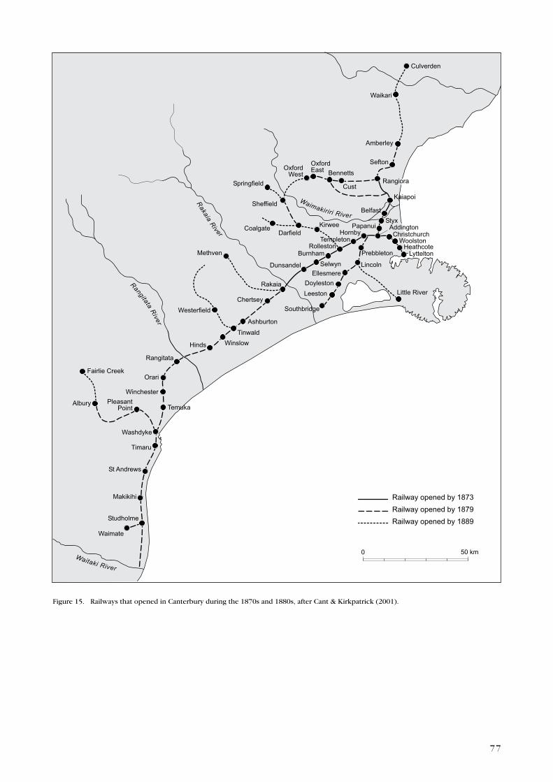
Canterbury experienced a surge in railway construction during the 1870s
and 1880s (Fig. 15). A branch railway line, 10 miles (c. 16 km) long, was
built between the Hurunui River and the south bank of the Waiau River
(Gardner 1956). The Hurunui railway bridge was built between 1883
and 1886, and the line to Culverden opened officially in 1886 (Gardner
1956) (Fig. 15).
4.2.5 Tourism
Tourism in the South Island high country was at first hindered by
the inaccessibility of the terrain (Grey 1994). Interest centred on
Mount Cook, the eastern piedmont lakes and the southwestern sounds
(Grey 1994). Tourist ventures in the 1880s were initially dependent on
an erratic pre-existing network of bullock tracks, and their development
helped pastoralism to penetrate further into mountainous territory
(Ian Hill, DOC, pers. comm. 2003).
All the main rivers in Canterbury had ferries by the mid-1860s and,
wherever possible, accommodation houses had been located at these
river crossings. Today, few exist, although some of the sites have had
more modern hotels built on them. In 2000, archaeologist Chris Jacomb
conducted a site investigation of the Pukaki Inn, which was the only
known remaining accommodation house site in the Mackenzie Basin
(Jacomb 2000).
europeans had begun to settle in the Mackenzie Basin in 1855, and in
1858, on the recommendation of the Canterbury Provincial Council,
construction of a dray track began there (Jacomb 2000). In 1862, the
Provincial Secretary called for tenders for the establishment of ferries
over the Tekapo, Pukaki and Ohau Rivers where the rivers were crossed
by dray tracks in the Mount Cook area (Andersen 1916). Terms included
in the lease of the ferry reserves on either side of the stream were that
the successful tenderer was to erect a house, provide sufficient oats at
eightpence per imperial quart, a safe ferry boat and shelter for stock.
Timber could be cut for construction and fuel, and reserves could be
set aside for this reason (Andersen 1916).
Jacomb found ‘that the tender issued in 1862 for a ferry at Pukaki
was not filled and that the first official ferry was established in 1876’
(Jacomb 2000: 49). Records show that in February 1876 two large boats
left Timaru for the Pukaki ferry, and in April George Tait was appointed
��
����������������������
����������������������
����������������������
�������������
������ �������������
����������
��������
������
����������
��������
���������
�������
������
�����
���������
����� �������
�������
�����������
�������
����������������
����
�������
�������
������������
������
��������
�������
���������
������������������������
���������������
���������
������������
����������� �����
������
�����
��������������
������� �����
���������
��������
������
��������� ������
����������������
�����������
�������
������������������
�������
����������
���������
���������������
�������������������������
�����������������
���������
� �����
Figure 15. Railways that opened in Canterbury during the 1870s and 1880s, after Cant & Kirkpatrick (2001).
��
ferryman (Andersen 1916). In the early 1890s, the ferry and hotel were
moved closer to the outlet of Lake Pukaki, c. 3 miles (c. 4.8 km) upstream,
and the ferry was replaced by a bridge in 1895 (Jacomb 2000). The
original accommodation house site was partially destroyed by controlled
spilling by hydroelectric plants and bulldozing in the late 20th century
(Jacomb 2000). The main features of the Pukaki Inn site are a concrete
chimney, which belonged to the accommodation house, the remains of a
forge, the remains possibly of a third building, and a boulder-lined dray
track (Jacomb 2000).
These provincial council initiatives boosted pastoralism and its expansion
in the district. For example, Birch Hill high-country station near Mount
Cook was first occupied by the Sicilian Nicolo (Big Mick) Radove in 1868
(Jacomb 2002). Jacomb also conducted a survey of the physical remains
at Birch Hill, and recorded the sites of three homesteads, one woolshed,
two ditch-and-bank enclosures, two graves, a sheep yard, a bivvy and a
possible forge (Jacomb 2002). A rabbit fence still separated Birch Hill
from the next station down the Tasman River, Glentanner. This was
runholding on the margins of possibility. Jacomb wrote: ‘The story of
Birch Hill is a story of hardship and struggle, life and death in a difficult,
remote environment’ (Jacomb 2002: 33). The run changed hands several
times and was eventually reclaimed by the wild when it became part of
the Mount Cook National Park (Jacomb 2002).
An early clash occurred between environmentalists and pastoralists when,
in 1884, a petition was sent to Government complaining of the destruction
of native vegetation there by burning off and grazing (Wigley 1979). A
ranger was appointed for the Mount Cook area in response. His name
was M.C. (Frank) Huddlestone of Timaru, a surveyor and watercolourist
(Wigley 1979). He soon became interested in establishing some tourist
accommodation, and purchased c. 30 acres (c. 12 ha) of land near the base
of Mueller Glacier (Wigley 1979). The first Hermitage hotel, believed to
have been a small cob building, was built. In 1885, Huddlestone sold
his land to the Mount Cook-Hermitage Company, which was set up to
develop a Swiss-style alpine village, and he became the first manager
(Wigley 1979).
This company ran its own coach service between Fairlie and The
Hermitage. Vehicles included a brake that could carry 16 passengers,
and two 12-passenger coaches (Wigley 1979). Another firm, McLeod and
Rossiter, set up in competition in 1888, with four covered-in coaches,
four wagonettes, and several buggies and gigs (Wigley 1979). It took
a visitor 3 days to travel from Timaru to Mount Cook. The first day
was spent travelling by train from Timaru to Fairlie, the second by
coach from Fairlie to Pukaki, and the third by coach to The Hermitage
(Wigley 1979).
On the Mackenzie Plains, the coaches followed the zigzag bullock tracks.
These were not metalled, and during the spring thaw they became
extremely muddy (Wigley 1979). In the summer, the same tracks were
very dusty. As the years went by, they sank, until they were 3 feet
(c. 0.9 m) or more below the surrounding ground and only a little more
��
than the width of the vehicles (Wigley 1979). Between Lake Pukaki and
The Hermitage, after rain or snow, the track was frequently gouged out
by water cascading off the mountain slopes, and sometimes travellers
were forced to ford 20 or 30 streams (Wigley 1979).
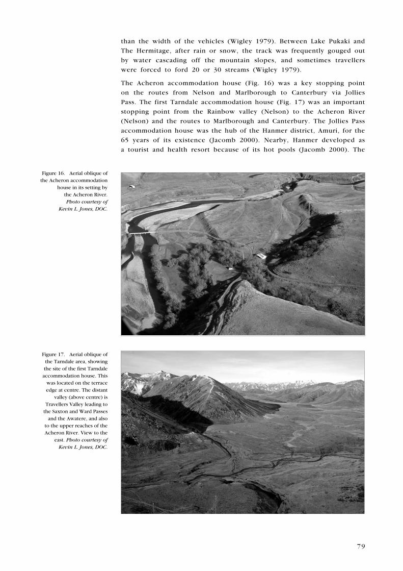
The Acheron accommodation house (Fig. 16) was a key stopping point
on the routes from Nelson and Marlborough to Canterbury via Jollies
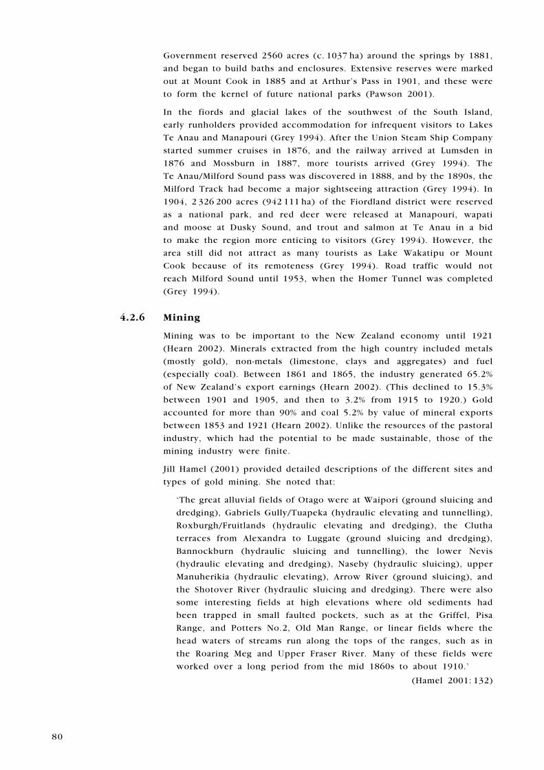
Pass. The first Tarndale accommodation house (Fig. 17) was an important
stopping point from the Rainbow valley (Nelson) to the Acheron River
(Nelson) and the routes to Marlborough and Canterbury. The Jollies Pass
accommodation house was the hub of the Hanmer district, Amuri, for the
65 years of its existence (Jacomb 2000). Nearby, Hanmer developed as
a tourist and health resort because of its hot pools (Jacomb 2000). The
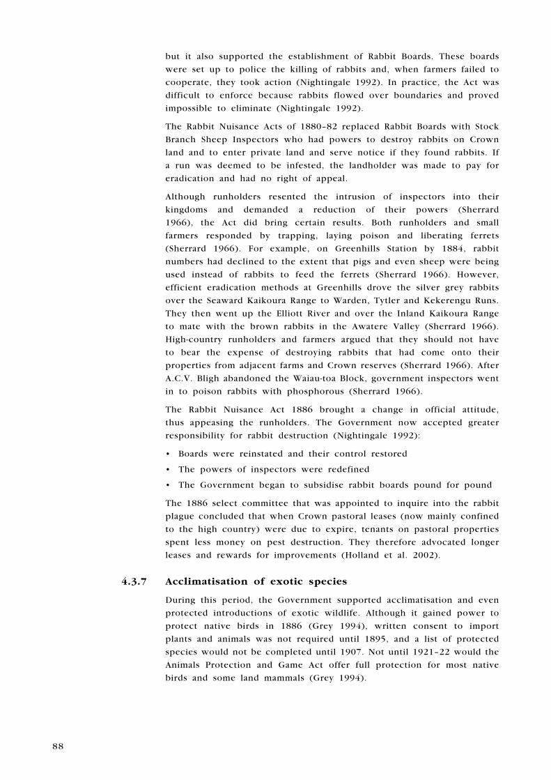
Figure 16. Aerial oblique of the Acheron accommodation
house in its setting by the Acheron River. Photo courtesy of
Kevin L. Jones, DOC.
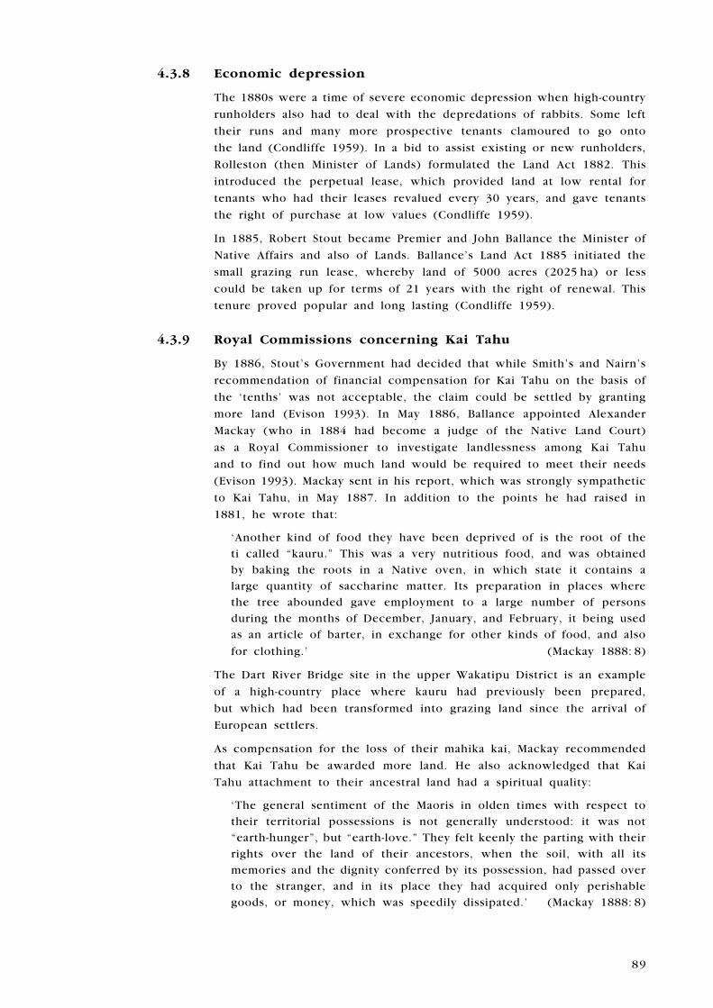
Figure 17. Aerial oblique of the Tarndale area, showing the site of the first Tarndale accommodation house. This
was located on the terrace edge at centre. The distant
valley (above centre) is Travellers Valley leading to
the Saxton and Ward Passes and the Awatere, and also
to the upper reaches of the Acheron River. View to the
east. Photo courtesy of Kevin L. Jones, DOC.
�0
Government reserved 2560 acres (c. 1037 ha) around the springs by 1881,
and began to build baths and enclosures. extensive reserves were marked
out at Mount Cook in 1885 and at Arthur’s Pass in 1901, and these were
to form the kernel of future national parks (Pawson 2001).
In the fiords and glacial lakes of the southwest of the South Island,
early runholders provided accommodation for infrequent visitors to Lakes
Te Anau and Manapouri (Grey 1994). After the Union Steam Ship Company
started summer cruises in 1876, and the railway arrived at Lumsden in
1876 and Mossburn in 1887, more tourists arrived (Grey 1994). The
Te Anau/Milford Sound pass was discovered in 1888, and by the 1890s, the
Milford Track had become a major sightseeing attraction (Grey 1994). In
1904, 2 326 200 acres (942 111 ha) of the Fiordland district were reserved
as a national park, and red deer were released at Manapouri, wapati
and moose at Dusky Sound, and trout and salmon at Te Anau in a bid
to make the region more enticing to visitors (Grey 1994). However, the
area still did not attract as many tourists as Lake Wakatipu or Mount
Cook because of its remoteness (Grey 1994). Road traffic would not
reach Milford Sound until 1953, when the Homer Tunnel was completed
(Grey 1994).
4.2.6 Mining
Mining was to be important to the New Zealand economy until 1921
(Hearn 2002). Minerals extracted from the high country included metals
(mostly gold), non-metals (limestone, clays and aggregates) and fuel
(especially coal). Between 1861 and 1865, the industry generated 65.2%
of New Zealand’s export earnings (Hearn 2002). (This declined to 15.3%
between 1901 and 1905, and then to 3.2% from 1915 to 1920.) Gold
accounted for more than 90% and coal 5.2% by value of mineral exports
between 1853 and 1921 (Hearn 2002). Unlike the resources of the pastoral
industry, which had the potential to be made sustainable, those of the
mining industry were finite.
Jill Hamel (2001) provided detailed descriptions of the different sites and
types of gold mining. She noted that:
‘The great alluvial fields of Otago were at Waipori (ground sluicing and
dredging), Gabriels Gully/Tuapeka (hydraulic elevating and tunnelling),
Roxburgh/Fruitlands (hydraulic elevating and dredging), the Clutha
terraces from Alexandra to Luggate (ground sluicing and dredging),
Bannockburn (hydraulic sluicing and tunnelling), the lower Nevis
(hydraulic elevating and dredging), Naseby (hydraulic sluicing), upper
Manuherikia (hydraulic elevating), Arrow River (ground sluicing), and
the Shotover River (hydraulic sluicing and dredging). There were also
some interesting fields at high elevations where old sediments had
been trapped in small faulted pockets, such as at the Griffel, Pisa
Range, and Potters No.2, Old Man Range, or linear fields where the
head waters of streams run along the tops of the ranges, such as in
the Roaring Meg and Upper Fraser River. Many of these fields were
worked over a long period from the mid 1860s to about 1910.’
(Hamel 2001: 132)
�1
Another Otago archaeologist, Peter Bristow (1998), gave a detailed
description of the technological changes in alluvial mining at earnscleugh
on the Clutha River from 1863 to 1963. DOC’s (1999) visitor information
brochure for the site stated that:
‘The earnscleugh tailings area has great historic significance, representing
the evolution of dredging from the early 1860s through to the 1960s.
The extent and preservation of the tailings display the sequence of
technological advancement through 100 years of gold dredging in this
area.’ (DOC 1999)
Ground sluicing left behind the classical herringbone pattern of early
mining.
Quartz (or hard rock) mining began in Otago in about 1863
(Hamel 2001) and continues to the present. Some sites were in remote
high-country locations, such as the Skippers and Dart Valleys. Notable
quartz mines were found at Glenorchy, Bullendale, Macetown, Carrick,
Bendigo, Oturehura and Macraes Flat. Hamel informed us that:
‘Archaeologically an old battery site will consist of at least two
platforms, generally cut into rock, often with concrete block
foundations set with bolts for the heavy machinery. On a lower level
there may be the foundations or remains of cyanide tanks. Along with
a race and a reservoir, set slightly above the battery, these are the
usual archaeological indications of 19th century quartz mining activity.
Some early mines may have no associated battery because the ore
was taken by dray to distant battery, or even shipped to Australia for
processing.’ (Hamel 2001: 165)
Crushing had begun at Bullendale by 1864, and a hydroelectric plant
was constructed to drive the machinery in 1886 (Hamel 2001). The
main period of active mining at Macetown was from 1876 to 1886
(Hamel 2001). The Invincible Lode high on a hillside in the Rees Valley
was worked successfully between 1882 and 1889 (Hamel 2001). At
Bendigo Creek, after the initial alluvial mining from 1862 to 1866, quartz
mining began in 1868 and continued until the early 20th century (Hamel
2001). Quartz mining had begun near Macraes Flat by May 1866 (Hamel
2001). Over time, the remains of this ‘Duke of edinburgh’ mine have been
eroded by ploughing, roading and the dumping of rubbish. The battery
and mine buildings have disappeared. The reservoir and a crumbling
stone house with sod-walled enclosures were still there in 2001. The
Carrick Field, established in 1870, ran up the mountainside from c. 1800
to c. 3180 feet (c. 550–970 m) above sea level (Hamel 2001). Quartzville,
at the base of the main spur, was a packers’ town, where loads were
transferred from drays to packhorses for the steep haul up to the mines.
However, little remained; house ruins, battery platforms and pieces of
machinery could be seen higher on the spur or along the gullies. At
the top of the range there was a huge iron waterwheel, and the long
Carrick water race constructed to provide water to the waterwheel and
to Bannockburn ran around the hillside (Hamel 2001).
�2
4.2.7 Scheelite mining
Most of the lodes in the Glenorchy goldfield carried more scheelite than
gold, and the largest and most productive were those on the Glenorchy-
Kelly Lodes on Mount Judah (Hamel 2001). These were worked between
the 1880s and 1977 (Hamel 2001).
4.2.8 Coal mining and sawmilling
Open-cast coal mining was carried out on a very small scale at Mount
Somers in Canterbury, Mataura and Nightcaps in Southland, and in Central
Otago, with little pits being used and abandoned as demand fluctuated
(Hearn 2002).
At Gabriels Gully, a sawmill operated for a time in the beech forest on
the spur for construction on the goldfields, but when the trees had gone,
the diggers themselves were forced to search for swiftly vanishing scrub
(Salmon 1963). In West Otago, the first small communities were reliant
on sawmilling and sheep (Olssen 1984). The great wave of miners into
the barren landscape of Central Otago, on the other side of the Old
Man Range/Kopuwai, created a strong demand for timber (Olssen 1984).
Soon, steam mills were constructed on the Pomahaka River and by 1870
the three largest mills were manufacturing c. 100 000 feet (c. 30 500 m)
per week (Olssen 1984). Around 100 bullock teams took the timber
to the different markets (Olssen 1984). Many small businesses, such as
blacksmiths, pubs and general stores, sprang up. At Tapanui there were
two small coal mines (Olssen 1984).
4 . 3 L A N D T e N U R e
4.3.1 Mining and pastoralism
Provincial governments wished to retain possession of potentially gold-
bearing land, much of which was in the high country. Some resolved this
issue by writing into their land regulations special clauses for leasing lands
in the goldfields (McDonald 1945). These leases were to be cancelled
when a goldfield was proclaimed. For example, James Chapman Smith and
John Martin had a licence for the 12 800-acre (5184-ha) Run 53 in Otago
when, in May 1861, Gabriel Read discovered gold there (McIntyre 2002).
This run was officially declared a goldfield, the partners’ depasturing
licence was cancelled, and they were given £1216 compensation by the
Government. Both men went on to make a fortune, not by mining but
by slaughtering their sheep for the instant local market and transporting
the miners’ gold to the banks in Dunedin (McIntyre 2002).
In Otago, the mining industry generated four key types of conflict:
Prospectors and miners gaining easy access to land versus landholders
protecting their property rights and interests
Miners using natural watercourses for discharging tailings, polluted
water and other debris versus settlers demanding that their riparian
rights be protected
•
•
�3
The exploitation of mineral wealth versus the preservation of the
pastoral or agricultural value of the land
The priorities of the mining industry versus the pastoral or agricultural
industries in the allocation of water resources
Policies and legislation were developed on an ad hoc basis in an attempt
to balance the interests of the competing industries, but when the
riparian rights and lands of settlers were at stake, the mining industry
invariably won, regardless of the cost to the environment, other resources
or local communities (Hearn 1981). Governments were committed to the
promotion of mining because of the key role that the industry played in
the colonial economy (Hearn 1981). T.J. Hearn has written exhaustively
about the changes in legislation that occurred as a consequence of the
controversy between the industries, and noted that at the heart of the
conflict between miners and settlers was the application of two different
rights structures to the same resources of land and water (Hearn 1981,
2002). Between 1860 and 1907, eight tenures were introduced: agricultural
leases (1860), deferred payments licences (1872), perpetual leases (1882),
small grazing runs (1885), leases-in-perpetuity (1892), occupation with
right of purchase (1892), occupational leases (1894) and renewable leases
(1907). All of these except deferred payments were types of leasehold.
Hearn commented that:
‘To meet miner demands, the right of entry to all leasehold lands was
reserved, all leases could be terminated if the land were required for
mining, and, in the case of four of the tenures, owners or occupiers
were not to have any right of action for any damage resulting from
the diversion or fouling of water courses.’ (Hearn 2002: 93)
In the 19th century, mining and land laws:
‘... imposed few restrictions on the use of resources, while discounting
social and environmental costs in the interests of sustained exploitation.
Gold miners interpreted mining law as offering unlimited licence for
their enterprise and sought appropriate measures whenever such
licence appeared to be under threat. Parliament largely acceded to
their demands.’ (Hearn 2002: 98)
4.3.2 Maori loss and protest
Maori, increasingly dismayed by the lack of adequate reserves and the
inexorable loss of their mahika kai, demanded use rights to land and
mineral wealth in the high country and elsewhere (evison 1993). For
example, in January 1874, Horei Kerei Taiaroa wrote to the native
minister, Donald McLean:
‘you must also observe that precious stones have been obtained by
the Pakeha from here such as gold, Greenstone & c and also that the
people, their sheep, cattle and their animals subsist on the Island.
My opinion is that it is not right that the minerals should be taken
from the Ground because the land has not been paid for by any other
people.’ (Taiaroa 1874)
•
•
�4
european officials mostly chose to ignore their complaints (evison
1993).
In June 1878, Wereta Tainui and others of Arahura wrote to the Premier
and Minister for Native Affairs pointing out that their kaika nohoanga
were scattered all over the South Island high country, foothills and
lowlands. They said:
‘We are known to be the permanent occupiers of this side of this island
of Waipounamu (Middle Island) of the portion called Te Poutini ...
‘Our eel pa’s [sic] are now in disuse when we go to prepare that
branch of our food we are driven away from there … we still retain
a right to our claims our Burial places and our cultivations … one
of the burial places still remains in the hands of the Natives but the
others are outside the portions retained by the Maories [sic], and
the cultivations are scattered all over the island it was impossible to
have them all together they are scattered about at different places
within the exterior boundaries of the land, that is why we say that
the Government should carefully investigate this matter of these
cultivations of ours, our parents and ancestors, if they had been
cultivations for an influential people like the Pakeha a law would
have been enacted to protect them … they have made a law that any
person found trespassing on their property will be prosecuted by the
owner the maories say those are our cultivations and they take no
notice.’ (Tainui 1878)
Because of these and other Maori protests concerning the loss of
land, mahika kai and kaika nohoanga (such as that by the prophet
Te Maiharoa on the upper Waitaki River), in 1878 Hori Kerei Taiaroa,
son of the Kai Tahu chief Te Matenga Taiaroa and Member of the House
of Representatives for Southern Maori, came to an agreement with
John Sheehan, Minister for Native Affairs, that a Commission of Inquiry
would be held into past purchases of Kai Tahu land (evison 1993). On
15 February 1879, a Royal Commission, comprising Judge Thomas Henry
Smith of the Native Land Court and Francis edward Nairn, a Nelson settler,
was appointed to investigate whether or not any promises remained to
be fulfilled and whether or not reserves had been made in terms of the
original agreements. Their brief was limited to the land sales that were
of interest to Taiaroa: Otakou, Kemp’s Purchase, Murihiku and Akaroa
(evison 1993). Taiaroa organised marae sessions with kaumatua to copy
down details of the myriad mahika kai and kaika nohoanga that Kai
Tahu had traditionally made use of in the Otakou and Kemp’s Blocks
(evison 1993). Note that it was for this inquiry that H.K. Taiaroa produced
his record of mahika kai that was to become important in the Waitangi
Tribunal claim, and which DOC now relies on for tenure review.
By late 1879, the Smith-Nairn Commission had examined 24 witnesses and
almost finished hearing evidence on Kemp’s Purchase (evison 1993). Grey’s
ministry fell in October. John Hall became Premier, William Rolleston
the Minister of Lands, and John Bryce Native Minister (evison 1993). In
April 1880, after the Commission had heard 65 further submissions, Bryce
�5
refused the Commission any more expenses. It went into recess with the
Murihiku hearings unfinished and never resumed (evison 1993).
On 31 January 1881, the Smith-Nairn Commission issued its report (Smith
& Nairn 1881). The Murihiku inquiry was not complete, but with regard
to the Otago, Kemp’s and Akaroa Purchases, the Commission had arrived
at definite conclusions (evison 1993: 456):
Kai Tahu at the time of these three purchases had been entitled to
the New Zealand Company’s ‘Tenths’, on the grounds that the Otago
and Kemp’s Deeds had been made out to the Company
Kai Tahu were therefore entitled to one-eleventh of the total proceeds
that the Crown had received from the sale of land within the Otago and
Kemp’s Blocks, with accumulated interest, less the value of reserves
and other government benefits that they had already received
Nothing happened. Attention was focused on the Parihaka crisis in Taranaki
(evison 1993). Alexander Mackay, Native Land Purchase Commissioner,
supported the Kai Tahu case in his official report of 1881, emphasising
the disadvantages they had been subjected to with the loss of their
mahika kai and kai moana, like those suffered by Te Maiharoa and his
people:
‘... on going fishing or bird-catching, they are frequently ordered off
by the settlers if they happen to have no reserve in the locality. This
state of affairs, combined with the injury done to their fisheries by
the drainage of the country, inflicts a heavy loss on them annually and
plunges them further into debt, or keeps them in a state of privation.
All this is very harassing to a people who not long since owned
the whole of the territory now occupied by another race, and it is
not surprising that discontent prevails, or that progress or prosperity
is impossible. The small quantity of land held per individual—viz.,
fourteen acres, and in some cases the maximum quantity is less—
altogether precludes the possibility of the Natives raising themselves
above the position of peasants. A european farmer finds even
100 acres too small to be payable …’ (Mackay 1881: 16)
4.3.3 Government centralisation
The role of the provincial councils had become more important
to the colony than that of the central General Assembly (Condliffe
1959). Some southern councils, like that of Otago during the 1860s
gold rush, had had more money than Central Government, which at
the time was funding the New Zealand Wars. Land legislation in the
various provinces had been inconsistent and confusing, and the cost of
running 11 legislatures in a colony with less than 300 000 people was
exorbitant (Condliffe 1959). Five South Island provinces—Marlborough,
Nelson (which included Amuri from 1853 to 1876), Canterbury, Otago
and Southland—had extensive areas of high country (McKinnon 1997).
The rapid development of a transport grid during Vogel-led governments
in the 1870s helped to facilitate travel from these remote districts
to the capital city. Centralisation of government at Wellington was
inevitable. The provincial councils were abolished in 1876. Their control
•
•
�6
of land legislation and administration could not have lasted indefinitely
(Condliffe 1959).
4.3.4 Freehold and leasehold
Vogel was voted out of office in 1877 and the Liberal leader Premier
George Grey brought in the Land Act 1877 to consolidate and systematise
the diverse array of provincial legislation (Condliffe 1959). Crown
pastoral leaseholders in the high country were affected by these laws
(Condliffe 1959; McLintock 1966):
The Government repealed 56 statutes and set up a centralised
policy.
Auction sales for pastoral leases were introduced and a system of
deferred payments in the sale of waste lands was adopted.
Crown land could be sold for cash or on deferred payments with
conditions requiring improvements and personal residence.
Special conditions were applied to pastoral runs in Canterbury and
Otago, with leases being offered at auction and occupiers being given
the right to freehold land around their homesteads.
The first land tax in the colony was initiated. Although low, at a flat
rate of a halfpenny in the pound on all land in excess of £500 in
value, it was repealed in 1879 when Grey lost office.
The provinces, provincial councils, commissioners and waste-lands
boards were replaced by land districts, land boards and commissioners
of Crown lands responsible to the minister.
Three key methods were frequently employed in the high country and
on the downlands to exclude competitors during the land boom of the
1870s. According to Hargreaves (1966), these were:
‘Spotting’, where runholders purchased key small sections, particularly
those near waterways, often by pre-emptive rights, leaving other
sections unusable.
‘Dummying’, when ownership of blocks of land was vested in other
family members or employees while really staying in the possession
of the runholder.
‘Gridironing’, which occurred when runholders bought several of the
smallest possible (20-acre; 8.1-ha) sections fronting a road, leaving
19-acre (c. 7.7 ha) sections in between. These could be sold only at
auction and were too small to be of much value to anyone else.
Despite these runholder techniques, as railways expanded and markets
became more accessible and land more valuable for resale, the percentage
of ‘cockatoos’ or small farmers grew (Hargreaves 1966).
In Canterbury Province by the end of 1878, all of the plains were
freehold (except for poor pieces of land). Crown pastoral leasehold was
now mostly confined to high country over 300 m and was divided among
182 properties averaging c. 22 000 acres (8910 ha). The biggest properties
were owned by large companies. These were mostly paper holdings
representing mortgages. The New Zealand Loan and Mercantile Agency
•
•
•
•
•
•
•
•
•
��
held 646 537 acres (c. 261 847 ha) and the Trust and Agency Company of
Australia held 427 427 acres (c. 173 108 ha). A few individuals or groups
owned areas of land in excess of 50 000 or 100 000 acres (20 250 or
40 500 ha).
Although Otago had larger pastoral runs and flocks, Canterbury was
regarded as the land of squatters and extensive runs (Scotter 1965). This
was probably because the pastoral interest in Canterbury had remained
powerful, while in Otago from the time of early european settlement
other industrial interests had challenged those of the runholders, such
as gold mining and the small-scale farming introduced by the hundreds
system.
During the late 1860s and the 1870s, the political power of the pastoralists
had been challenged by groups who aimed to bring about radical land
law reform: ex-goldminers, immigrants from Britain who arrived as part
of Premier Julius Vogel’s expansionist programme, and urban businessmen
and promoters who wanted closer settlement around their towns
(Hearn 1971). However, the power of high-country runholders was not
challenged until technological advancement undermined the commercial
importance of the wool markets (Hearn 1971). The freezing works that
sprang up along the east coast of Canterbury, Otago and Southland in
the 1880s and early 1890s were to boost the number of small farmers
and their economic and political clout.
4.3.5 Scab control
After Government had been centralised, the campaign against pastoral
pests intensified. The abolition of provincial governments and passing of
the Sheep Act 1878 together dismantled local resistance to the control
of scab in the high country and elsewhere (Sherrard 1966). According
to McKinnon (1997):
Sheep districts and subdivisions were established, and staff were
appointed to inspect flocks
Penalties were imposed for the possession of infected sheep, and the
movement of sheep by sea and land was monitored
Quarantine stations and designated crossing places were set up, and
methods were prescribed for disposing of infected animals
Scab disappeared during this period. Canterbury, Napier and Otago
Districts were declared free of the disease in 1879 (Scotter 1965). They
were still the only clean districts in 1884. Although Amuri was declared
clean in 1885, 10 000 sheep were destroyed in the following year on
a run near Kaikoura (Scotter 1965). Another 800 sheep were killed in
Kaikoura in 1889. New Zealand as a whole was not declared clean until
1892 (Scotter 1965).
4.3.6 Rabbit destruction
efforts to eradicate rabbits from the high country (and New Zealand
in general) were not so successful. The Rabbit Nuisance Act 1876
emphasised that rabbit destruction was the responsibility of the farmer,
•
•
•
��
but it also supported the establishment of Rabbit Boards. These boards
were set up to police the killing of rabbits and, when farmers failed to
cooperate, they took action (Nightingale 1992). In practice, the Act was
difficult to enforce because rabbits flowed over boundaries and proved
impossible to eliminate (Nightingale 1992).
The Rabbit Nuisance Acts of 1880–82 replaced Rabbit Boards with Stock
Branch Sheep Inspectors who had powers to destroy rabbits on Crown
land and to enter private land and serve notice if they found rabbits. If
a run was deemed to be infested, the landholder was made to pay for
eradication and had no right of appeal.
Although runholders resented the intrusion of inspectors into their
kingdoms and demanded a reduction of their powers (Sherrard
1966), the Act did bring certain results. Both runholders and small
farmers responded by trapping, laying poison and liberating ferrets
(Sherrard 1966). For example, on Greenhills Station by 1884, rabbit
numbers had declined to the extent that pigs and even sheep were being
used instead of rabbits to feed the ferrets (Sherrard 1966). However,
efficient eradication methods at Greenhills drove the silver grey rabbits
over the Seaward Kaikoura Range to Warden, Tytler and Kekerengu Runs.
They then went up the elliott River and over the Inland Kaikoura Range
to mate with the brown rabbits in the Awatere Valley (Sherrard 1966).
High-country runholders and farmers argued that they should not have
to bear the expense of destroying rabbits that had come onto their
properties from adjacent farms and Crown reserves (Sherrard 1966). After
A.C.V. Bligh abandoned the Waiau-toa Block, government inspectors went
in to poison rabbits with phosphorous (Sherrard 1966).
The Rabbit Nuisance Act 1886 brought a change in official attitude,
thus appeasing the runholders. The Government now accepted greater
responsibility for rabbit destruction (Nightingale 1992):
Boards were reinstated and their control restored
The powers of inspectors were redefined
The Government began to subsidise rabbit boards pound for pound
The 1886 select committee that was appointed to inquire into the rabbit
plague concluded that when Crown pastoral leases (now mainly confined
to the high country) were due to expire, tenants on pastoral properties
spent less money on pest destruction. They therefore advocated longer
leases and rewards for improvements (Holland et al. 2002).
4.3.7 Acclimatisation of exotic species
During this period, the Government supported acclimatisation and even
protected introductions of exotic wildlife. Although it gained power to
protect native birds in 1886 (Grey 1994), written consent to import
plants and animals was not required until 1895, and a list of protected
species would not be completed until 1907. Not until 1921–22 would the
Animals Protection and Game Act offer full protection for most native
birds and some land mammals (Grey 1994).
•
•
•
��
4.3.8 Economic depression
The 1880s were a time of severe economic depression when high-country
runholders also had to deal with the depredations of rabbits. Some left
their runs and many more prospective tenants clamoured to go onto
the land (Condliffe 1959). In a bid to assist existing or new runholders,
Rolleston (then Minister of Lands) formulated the Land Act 1882. This
introduced the perpetual lease, which provided land at low rental for
tenants who had their leases revalued every 30 years, and gave tenants
the right of purchase at low values (Condliffe 1959).
In 1885, Robert Stout became Premier and John Ballance the Minister of
Native Affairs and also of Lands. Ballance’s Land Act 1885 initiated the
small grazing run lease, whereby land of 5000 acres (2025 ha) or less
could be taken up for terms of 21 years with the right of renewal. This
tenure proved popular and long lasting (Condliffe 1959).
4.3.9 Royal Commissions concerning Kai Tahu
By 1886, Stout’s Government had decided that while Smith’s and Nairn’s
recommendation of financial compensation for Kai Tahu on the basis of
the ‘tenths’ was not acceptable, the claim could be settled by granting
more land (evison 1993). In May 1886, Ballance appointed Alexander
Mackay (who in 1884 had become a judge of the Native Land Court)
as a Royal Commissioner to investigate landlessness among Kai Tahu
and to find out how much land would be required to meet their needs
(evison 1993). Mackay sent in his report, which was strongly sympathetic
to Kai Tahu, in May 1887. In addition to the points he had raised in
1881, he wrote that:
‘Another kind of food they have been deprived of is the root of the
ti called “kauru.” This was a very nutritious food, and was obtained
by baking the roots in a Native oven, in which state it contains a
large quantity of saccharine matter. Its preparation in places where
the tree abounded gave employment to a large number of persons
during the months of December, January, and February, it being used
as an article of barter, in exchange for other kinds of food, and also
for clothing.’ (Mackay 1888: 8)
The Dart River Bridge site in the upper Wakatipu District is an example
of a high-country place where kauru had previously been prepared,
but which had been transformed into grazing land since the arrival of
european settlers.
As compensation for the loss of their mahika kai, Mackay recommended
that Kai Tahu be awarded more land. He also acknowledged that Kai
Tahu attachment to their ancestral land had a spiritual quality:
‘The general sentiment of the Maoris in olden times with respect to
their territorial possessions is not generally understood: it was not
“earth-hunger”, but “earth-love.” They felt keenly the parting with their
rights over the land of their ancestors, when the soil, with all its
memories and the dignity conferred by its possession, had passed over
to the stranger, and in its place they had acquired only perishable
goods, or money, which was speedily dissipated.’ (Mackay 1888: 8)
�0
Stout’s Government was replaced by that of Atkinson in October 1887. On
10 December 1890, Mackay was again appointed as a Royal Commissioner,
this time to find out which individual Kai Tahu actually had insufficient
land on which to support themselves (evison 1993).
Mackay submitted his report in May 1891 (evison 1993). He found that
of about 1500 Kai Tahu in Canterbury, Otago and Murihiku, only Taiaroa
and one other, Topi Patuku, had more than 500 acres (202.5 ha) of land,
while nearly half the people had none at all. The Kai Tahu reserves were
mostly land of inferior quality and those that had been of better quality
had become less fertile because of overuse. For example, when asked
by William Rolleston, Under-secretary in the Native Department, at the
Native Land Court in Dunedin if he tilled his land when it was ‘worn
out’, Horomona Pohio, who had accompanied the prophet Te Maiharoa
during his occupation of Te Ao Marama and had been his spokesman,
replied, ‘When it is worn out we should desert it but are obliged to go
on cultivating. If we had other land we should leave worn out land and
let it recover and then return’ (Pohio 1868). Growing numbers of Maori
were leasing their land to europeans (evison 1993). Many were poor and
depressed, and saw no hope for the future (evison 1993).
4.3.10 Runholders and the Long Depression
Some high-country runholders left their land during the Long Depression
(1879 to the mid-1890s), a number of whom were forced to give up
their holdings to loan and other financial companies (Scotter 1965). By
the end of the 1880s, the previously 509 runs held in 182 properties
in Canterbury had been reduced to 336 runs worked as 66 holdings
(Scotter 1965). Twenty-two Canterbury properties passed into the hands
of finance companies between 1879 and 1890 (Acland 1975). They were
all large pastoral stations, 15 of which were high-country runs and were
probably leased from the Crown. Numerous runholders had been ruined
by the depression, scab, rabbits and snow (Scotter 1965). However, the
largest high-country leaseholdings were secure. For instance, William
Gerard still held 21 runs amounting to 134 868 acres (c. 54 622 ha)
on Double Hill, Manuka Point and Snowdon, and ran 54 000 sheep
(Scotter 1965).
When the Canterbury leases were due to be renewed in 1889, the
runs were rearranged into three classes before being re-offered
(Scotter 1965):
The western, high-country areas, including the mountain tops, glaciers
and shingle slopes—2.3 million acres (931 500 ha), were divided into
68 holdings of mostly well over 5000 acres (2025 ha) each
Better land, which could possibly be economically worked in blocks
of 5000 acres or fewer, and which was used to establish 50 runs of
a total of 154 000 acres (62 370 ha)
51 000 acres (20 655 ha) on or adjacent to the Plains, which were
divided into 19 agricultural/pastoral runs
•
•
•
�1
For a decade, land officers had been urging fixity of tenure to encourage
better care of runs, and on 31 May 1889 the Canterbury runs south
of the Rangitata River were offered at auction on fixed terms of
10–21 years (Scotter 1965). J.B.A. Acland and C.G. Tripp renewed theirs.
George Rutherford outbid Thomas Teschemaker for his Otaio run, allegedly
from spite over a horse-racing scandal (Scotter 1965). There were no
bids for those infested by rabbits in the Mount Cook region. Northern
Canterbury runs were offered on 4 June with the same fixed tenure, and
William Gerard and G.A. McMillan renewed their leases (Scotter 1965).
The Loan and Mercantile Company now held 330 000 acres (133 650 ha),
half of the area it held before, and there were few banks or companies
among the other lessees (Scotter 1965).
In Amuri County, there were relatively few changes of ownership up to
the end of the 19th century, which contrasts with the earlier period. By
the early 1880s, the district was known as ‘one of the last great squatters’
preserves in New Zealand. Securely freeholded, the stations were legally
impregnable until their owners chose to sell, or until Parliament enacted
a new kind of land legislation’ (Gardner 1956: 290). Although half the
great estates were for sale, the mortgagees refused to sell at a loss and
rarely sold at a profit (Gardner 1956). Since New Zealand was in the
throes of depression, anticipated subdivisions did not occur when the
railway reached Culverden in 1885 (Gardner 1956). In both Canterbury
and Marlborough, the banks and the station agencies had increasing
numbers of properties to sell. even though in Amuri County nearly all
runs carried mortgages, runholders mostly weathered the storm because,
according to Gardner (1956), they possessed fine properties and managed
them well.
During these harsh economic times, pastoralists with vast runholdings,
including those in the high country, were often attacked publicly
(Gardner 1956). Many people believed that land aggregators were
preventing hard-working and thrifty farmers from taking up small blocks
of land (Gardner 1956). In response to such hostility, Andrew Rutherford
wrote wryly to the Marlborough Express that squatters, like the moa,
were about to become extinct, and that he was anxious to preserve a
few in Amuri so that future generations would have something to abuse
(Gardner 1956). Despite Rutherford’s pessimism, after the depression
ended in c. 1895, the Amuri runs were to enjoy an Indian summer of
fame and prosperity, and the runholders became known throughout New
Zealand as the ‘Amuri Wool Kings’ (Gardner 1956).
By 1892, most of the best land in New Zealand had been freeholded.
Vast high-country areas were still owned by the Crown but, in general,
these were of poor quality, rabbit infested or isolated with difficult access
(Condliffe 1959).
�2
4 . 4 S U M M A R y
4.4.1 General historical features
Increasing pressure on land available for development
Intensification of farming methods
Population explosion and rapid development of the transport grid
Declining land fertility and stock numbers
Centralisation of government land administration (1876) leading to
uniformity of Crown pastoral leases
elimination of scab assisted by central government control of provincial
law and its administration
Ascendancy of rabbits
Construction of homesteads and station buildings using materials
manufactured nearby or brought in from outside, and erection of
grander houses
The advent of refrigeration in the 1880s encouraged cross-breeding
of sheep for meat and for wool, sowing of permanent exotic pasture,
fencing of paddocks, and growing of supplementary winter crops on
low-lying land
Crown pastoral leasehold land mainly confined to the high country
Development of tourist routes, hotels and coach services
Mining and sawmilling
4.4.2 Key physical resources
Light (No. 8 gauge) wire fences
Rabbit-proof fences, rabbiters’ huts and rabbit-poison containers
Snow fences
Flood gates and road gates
Homesteads, many of which were built of imported materials
Other station buildings, such as shearers’ quarters and woolsheds
Clusters of buildings and trees encompassing the homesteads
Droving tracks
Tourist routes
Accommodation houses and hotels
Mail and passenger coaches
Roads, railways, bridges and telegraph lines
Quarantine stations
Sheep dips
Use of concrete for station construction
Abandoned mines and sawmills
•
•
•
•
•
•
•
•
•
•
•
•
•
•
•
•
•
•
•
•
•
•
•
•
•
•
•
•
�3
5. 1891–1912: The Liberal era
5 . 1 L A N D S C A P e M O D I F I C A T I O N
By 1890, throughout the mountainous and lower sub-alpine areas, tall
tussock grasslands had been transformed by fire and grazing pressure to
short grasslands. Areas that were once the domain of indigenous species
had been invaded by naturalised grasses from Australia, California and
europe. Throughout the high country, but especially in drier parts, native
grassland ecosystems had been steadily altered by exotic grasses tolerant
of low soil fertility, by sheep and cattle grazing, and by rabbit browsing.
There were few palatable herbs in tussock grassland; consequently, these
areas could easily be overgrazed (Holland et al. 2002). The result was a
steady depletion of the range lands. By this time, rabbits had become a
plague in many parts of the high country (Holland et al. 2002).
In 1910, F.W. Flanagan, H.D.M. Haszard and James Stevenson, Crown
Lands Commissioners, when reporting on the Canterbury pastoral runs
wrote:
‘In travelling over the Mackenzie Plains one is impressed with a weary
feeling of sadness and regret at the large extent of country which
is almost depleted of all vegetation, save sorrel and “scab-weed.”
The affected area contains about 90,000 acres. The dead and dying
condition of the native grasses over such a large area is a matter of
grave importance to the Dominion. There is amongst the settlers in
the Mackenzie country a difference of opinion as to the cause of the
depletion. The oldest settlers allege that it is due primarily to the
burning of the native tussock some forty years ago, and that, owing to
the ravages of rabbits, frosts, droughts, and high winds characteristic
of the climate, it has not been able to become re-established.’
(Flanagan et al. 1910: 7)
The commissioners concluded that probably nothing had contributed
more to the widespread destruction of pastoral high country than the
indiscriminate burning of native tussock (Flanagan et al. 1910). The
result had been a dramatic reduction in the carrying capacity of the
properties. While they thought that ‘a proper amount of burning at the
proper season’ was necessary and beneficial, the real damage was done
by the summer burning (Flanagan et al. 1910: 8). This type of burning,
which they said should be stopped, was usually done by musterers,
who signalled to one another from ranges by fires, which were allowed
to spread rapidly unchecked (Flanagan et al. 1910). When fire swept
over the sunny faces, the tussock almost burnt out, and in a very dry
summer fire would wipe it out altogether. Then the mountains would
begin to disintegrate—rocks would loosen, tearing away the mountain
sides and triggering shingle slides. The commissioners wrote that ‘As
a rule, pastoral lessees give their irresponsible musterers a free hand
as to burning’ (Flanagan et al. 1910: 9). They recommended that new
licenses contain a condition prohibiting the burning of native grasses,
�4
except in spring, to create firebreaks, and that inspection of pastoral
runs be carried out systematically. Rabbit inspectors could perform this
task as part of their inspection work in the high country (Flanagan et
al. 1910). The commissioners also recommended that, wherever possible,
english grasses be sown on the surface, and that the Government plant
the Mackenzie Country with trees to ameliorate extremes of temperature,
help make the country safer for stock and create shelter. They advised
that reserves for travelling stock be established (Flanagan et al. 1910).
At the same time, botanist Alfred Cockayne published the first serious
scientific study of farming practices on tussock grasslands for the
Department of Agriculture (Cockayne 1910). He firmly rejected any
arguments in favour of burning, contending that it increased pasture
growth and carrying capacity only briefly, and that the ultimate
consequence was deterioration and depletion:
‘I am fully aware that even now many runholders will scout the idea
that burning will, if persisted in, cause an almost entire depletion of
most of the natural grazing areas in the drier portions of the South
Island. One has only to point to the deplorable conditions of many
of our southern runs, however, to appreciate the significance of this
pernicious practice.’ (Cockayne 1910: 15)
By the late 19th century, landholders and government agencies began to
appreciate that open-country environments require diligent management to
ensure their continuing productivity (Holland et al. 2002). The vegetation
depletion and degradation brought about by fire and grazing animals
had caused stocking rates to plummet. There were 511 188 sheep in
Vincent County, Central Otago, in 1880, but just 315 757 40 years
later (Holland et al. 2002). On the rabbit-infested lands of Galloway
Station in Central Otago, sheep numbers fell from 75 000 in 1879 to
21 000 in 1904 (Holland et al. 2002), when land degradation was at its
worst. In open country where unimproved grassland prevailed, carrying
capacity began to decline in the 1880s, the area covered by scabweed
expanded alarmingly, shingle fans grew and steeper slopes failed (Holland
et al. 2002). After the boom year of 1878, falling wool prices, several cold
winters (which culminated in the heavy snows of 1895) and runholders’
attempts to maintain sheep numbers despite increased numbers of rabbits
resulted in reduced wool clips from malnourished Otago sheep (Holland
et al. 2002). By comparison, in New Zealand as a whole, refrigeration
(which meant that sheep could be bred for meat as well as wool) had
stimulated an increase in sheep numbers from 12 985 000 in 1881 to
20 233 000 in 1901 (Thornton 1986).
In one account, written in the early 1890s, the owner of Molesworth
Station, William Acton-Adams, described the soil erosion on the elliott
run:
‘If you notice the slopes of the hills, particularly at the upper end, the
surface is peeling away through the rabbits and dry weather and large
patches of land are becoming useless. This is exactly what ruined the
Awatere Runs and it threatens to ruin a great part of this block.’
(Acton-Adams 1891, cited in McCaskill 1970: 76)
�5
By the early 20th century, most high-country mahika kai had been
destroyed, especially in Kemp’s Block (evison 1993). High-country bush
continued to be razed by burning and sawmilling. For example, it is
thought that the bush at Freehold Creek continued to be cut until around
1903 (Ian Hill, DOC, pers. comm.). Stoats and cats were killing native
birds (evison 1993). Deer were penetrating the forested river valleys.
In 1892, Reverend P. Walsh, an amateur botanist, published a warning
concerning the introduction of deer to the country. Whereas in europe
deciduous trees had evolved in the presence of ruminants of many types,
in New Zealand the situation was quite the reverse. He wrote that the
forest had evolved in the absence of any four-footed browsing animals,
and the constituent parts were so interdependent for nourishment and
protection that once the balance was disturbed, the entire growth would
rapidly deteriorate (McCaskill 1973). His warning went unheeded and
deer were protected for many years.
5 . 2 P H y S I C A L R e M A I N S
5.2.1 Effects of refrigeration
Historian Jim McAloon contended that:
‘Of all the changes in the farming sector between 1880 and 1914,
the most important were those related to refrigeration. Whereas once
the entire primary exporting sector had been dominated by wool, by
1900 this was no longer so. Meat, butter, and cheese had provided
alternative and more reliable sources of income. The rise of the
frozen meat industry added to the incentives for improving flocks,
as it created the need for different breeding arrangements in order
to achieve a type of sheep that would produce optimum meat and
wool.’ (McAloon 2002: 49)
The invention of refrigerated shipping altered the relationship between
runholder and small farmer. Meat had become at least as valuable as
the fleece. Refrigeration made possible the production of meat and
also dairy products for overseas markets on small, intensively farmed
blocks of land. By the late 1880s, freezing works had been built by the
main ports (Hornby, Islington, Ashburton, Smithfield, Pukeuri, Burnside,
Mataura, Makarewa and Ocean Beach) and a few ships had been fitted
out. Prosperity returned after 1895, continuing until 1921, and small
farmers flourished, becoming a force politically. American anthropologist
elvin Hatch wrote that:
‘Refrigerated shipping, then, did not eliminate the distinction between
farmers and run-holders, for now two rather different kinds of sheep
raising coexisted. One, sheep farming, was a variety of intensive
agriculture, for it involved the use of agricultural equipment to work
the soil. The people who engaged in this production were cockies;
their farms were labor intensive, they required only a few hundred
acres to support their families, and their incomes came from the sale of
both meat and wool. The other form, run-holding, was a continuation
�6
of extensive [high-country] pastoralism, inasmuch as the flock consisted
of merinos that were fed on tussock. Agricultural equipment played a
minor role in the run’s operation, which was not labor intensive. A
minimum of several thousand acres were needed to support a family.
And a large majority of the run-holder’s income came from the sale
of wool.’ (Hatch 1992: 28)
5.2.2 Great estates
Runholders of large areas in the high country and on the foothills and
plains (sometimes known as ‘gentry’) were set apart from the workers
and the small farmers by their spacious homes and gardens and the
number of household and station staff they employed (Hatch 1992).
Figure 18 shows staff at Castle Hill Station, and Fig. 19 gives a more
distant perspective of the station buildings, with a water reservoir in the
foreground. Runholders came from varied backgrounds and had a wide
range of incomes. Some originated from Britain’s upper middle class,
others had been poor but astute and experienced Scots shepherds. Some
had small, poorly situated and marginal holdings, while others leased or
owned several estates (Hatch 1992). Wealthy runholders led a genteel
social life, organising parties for activities such as tennis, hunting and
shooting (Hatch 1992). Two examples of prominent pastoral runs are
Cheviot (part of which was Canterbury high country) and Otekaike
(Otago high country).
Cheviot
William Robinson had purchased land between the Hurunui and
Waiau Rivers on the Cheviot Hills Run of J.S. Caverhill in 1856, the
western part of which included the high-country Lowry Peaks district
(Gardner 1990). Between 1857 and 1862 he freeholded the 84 000-acre
(34 020-ha) Cheviot Hills Run. His great wealth did not make him popular
during the Long Depression, and his extravagant purchases of land,
stock and buildings earned him the nickname ‘Ready Money Robinson’
(Gardner 1990). However, he was also an extremely competent pastoralist.
In 1879, he built the Port Robinson slipway and the Hurunui Bridge,
and his large mansion was completed in 1888 (Gardner 1990). Historian
W.J. Gardner wrote that ‘Cheviot Hills became a self-sufficient kingdom
and a symbol of runholder wealth. A lover of trees and birds, Robinson
surrounded his house with gardens and plantations and set out miles of
hawthorn hedges, parts of which still survive’ (Gardner 1990: 371). The
year of his peak sheep return was 1886, when 105 000 were counted.
Otekaike
A station in northern Otago, initially known as ‘Run 28’ and with
boundaries at Kurow and Otekaike Creeks, was later known as ‘Otekaike’
(Hall 1985). It was first licensed in 1854 to Samuel Hillier Pyke, but
soon changed hands twice. The third owner, John Parkin Taylor, lived
in a cave. In 1861, William Heywood Dansey purchased the property and
quarried limestone near this cave to construct a dwelling (Hall 1985). In