4.10 seawinds near-real-time scatterometer winds for awips
TRANSCRIPT

4.10 SEAWINDS NEAR-REAL-TIME SCATTEROMETER WINDS FOR AWIPS
Jeffrey M. Augenbaum* and Raymond W. Luczak Computer Sciences Corporation, Suitland, MD
Gene Legg
NOAA/NESDIS, Suitland, MD
1 INTRODUCTION
NOAA/NESDIS produces a suite of near-real-time (NRT) wind vector and daily ice products from the QuikSCAT and ADEOS-II SeaWinds Scatterometer retrievals using the SeaWinds Processing system which is enhanced and maintained under the Computer Sciences Corporation's (CSC) Central Satellite Data Processing (CSDP) contract.
An effort is underway to make a near-real-time winds product available for the Advanced Weather Interactive Processing System (AWIPS). Recent efforts have successfully modified the QuikSCAT NRT processing system to include the Marine Scatterometer AWIPS winds product. A similar product for SeaWinds on ADEOS-II will follow. In this paper we describe the new regionalized SeaWinds AWIPS product, how it is integrated into the current QuikSCAT processing environment, and report on the status of this effort.
2 NOAA/NESDIS SEAWINDS NRT PROCESSING SYSTEM
2.1 NRT Data Processing
SeaWinds processing at NOAA/NESDIS consists of the ingest and data processing of scatterometer data from identical SeaWinds instruments on QuikSCAT and ADEOS-II (renamed Midori-II) spacecraft.
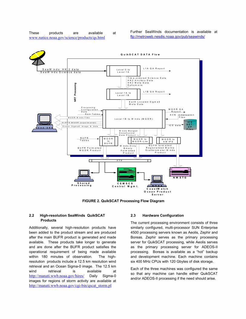
The SeaWinds NRT processing system at NOAA/NESDIS continues to be enhanced by collaboration between JPL and NOAA/NESDIS. Details of the NRT processing system’s data flow are contained in Augenbaum, et. al. (2001, 2002 and 2003) and summarized in Figures 1 and 2. Figure 1, shows the general flow of SeaWinds QuikSCAT data from acquisition through processing, while Figure 2, gives a detailed look at the flow of QuikSCAT data
through the NRT processing system at NOAA/NESDIS. The original operational mission requirement was to produce wind retrievals in 25 km resolution Wind Vector Cells (WVC) on an orbit-by-orbit basis within three hours of observation and to make them available in BUFR format. The Merged Geophysical Data Record (MGDR) product contains both the wind retrievals along with the sigma-0 values for each wind vector cell.
FIGURE 1. QuikSCAT Data Flow Diagram
Additional products have been added to the processing stream, on an operational basis, and are made available to the user community. These include a winds-only product of the primary wind retrieval, produced in a binary format at the request of the marine community, and daily ice products based on algorithms developed by Dr. David Long (BYU).
The latest 24 hours of Wind fields are available at http://wwwo2c.nesdis.noaa.gov/owinds/winds_browse_framed.htm Archived images of older data can be found at http://manati.wwb.noaa.gov/quikscat/
The daily ice image products are available at http://manati.wwb.noaa.gov/cgi-bin/qscat_ice.pl In addition, the National Ice Center produces their own images from the BYU-MERS "sir" image formatted data. They are currently distributing near-real-time ice images of the northern and southern hemisphere.
* Corresponding author's address: Dr. Jeffrey Augenbaum, CSC,NOAA/NESDIS, 4401 Suitland Rd., FB#4, Suitland, MD 20746; e-mail [email protected]
These products are available at www.natice.noaa.gov/science/products/qs.html
Further SeaWinds documentation is available at ftp://metroweb.nesdis.noaa.gov/pub/seawinds/
O c e a n S i g m a 0 im a g e & d a t a
Q u i k S C A T D A T A F l o w
L e v e l 0 t oL e v e l 1 A
L e v e l 1 A t oL e v e l 1 B
NR
T P
roce
ssin
gT im e - o r d e r e d S c ie n c e D a t aH K 2 A n c i la r y D a t aH K 2 M e t a D a t aE p h e m e r is
E a r t h L o c a t e d S ig m a 0M e t a D a t a
L 1 A Q A R e p o r t
L 1 B Q A R e p o r t
M G D R W i n d s F i l e s
W i n d s M e r g e dG e o p h y s i c a lD a t a P r o d u c t
M G D R Q AR e p o r t
P r o c e s s i n gC o n f i g u r a t i o nD a t a
R a i n T a b l e s
M G D Rt o
B U F R
B U F RT a b le s
B U F R F o r m a t t e d M G D R P r o d u c t
M G D R t oM G D R - L i t e
W in d s - O n lyB in a r y
F o r m a t t e d P r o d u c t
S e a W in d s H K 2 d a t aS e a W in d s S c ie n c e d a t a
H I - R E S M G D R ( e x p e r im e n t a l )
A V N I n i t ia l i z a t i o nF i le s
I C E d a t a
F T P
I C ES E T -
U PF i l e s
L e v e l 1 B t o W in d s ( M G D R )
M G D R t oA W I P S
B U F R f o r m a t t e dR e g io n a l i z e d M a r in eS c a t t e r o m e t e r W in d s
P r o d u c t
S h a r e dP r o c e s s i n g
N O A A / O R A
N W S T G
N O A AC o a s t W a t c h
O c e a n P r o d u c tS e r v e r
C E M S C SC e n t r a l M g m t .
FIGURE 2. QuikSCAT Processing Flow Diagram
2.2 High-resolution SeaWinds QuikSCAT Products
Additionally, several high-resolution products have been added to the product stream and are produced after the main BUFR product is generated and made available. These products take longer to generate and are done after the BUFR product satisfies the operational requirement of being made available within 180 minutes of observation. The high-resolution products include a 12.5 km resolution wind retrieval and an Ocean Sigma-0 image. The 12.5 km wind retrieval is available at http://manati.wwb.noaa.gov/hires/ Daily Sigma-0 images for regions of storm activity are available at http://manati.wwb.noaa.gov/cgi-bin/qscat_storm.pl
2.3 Hardware Configuration
The current processing environment consists of three similarly configured, multi-processor SUN Enterprise 4500 processing servers known as Aeolis, Zephir and Boreas. Zephir serves as the primary processing server for QuikSCAT processing, while Aeolis serves as the primary processing server for ADEOS-II processing. Boreas is available as a “hot” backup and development machine. Each machine contains six 400 MHz CPUs with 120 Gbytes of disk storage.
Each of the three machines was configured the same so that any machine can handle either QuikSCAT and/or ADEOS-II processing if the need should arise.
3 MARINE SCATTEROMETER WINDS PRODUCT FOR AWIPS
3.1 AWIPS Scatterometer Winds Product Description
We have recently modified the QuikSCAT NRT processing system to include a new Marine Scatterometer Wind product for AWIPS. This product consists of a reduced set of field variables derived from the full MGDR BUFR product. Unlike the full MGDR BUFR product which encodes all points, whether or not a valid retrieval was calculated, the AWIPS product only encodes those points where a valid wind retrieval is produced. A complete list of field variables and the corresponding BUFR descriptors for the AWIPS product is given in Table 1.
BUFR Descriptor
Field ID 1007 satellite ID 5040 orbit number 4001 year of observation 4002 month of observation 4003 day of observation 4004 hour of observation 4005 minute of observation 4006 second of observation 5002 latitude of observation 6002 longitude of observation 21109 quality flag 21120 SeaWinds Prob of Rain 11012 wind speed 11011 wind direction
Table 1. AWIPS BUFR Descriptors
In addition to the BUFR encoding, each BUFR message is preceded with a WMO header and a National Weather Service Telecommunications gateway (NWSTG) Flag Field separator. The Flag Field separator is used by the NWS telecommunications gateway to separate out individual BUFR bulletins from the AWIPS BUFR file and to route the individual BUFR bulletin messages. The WMO header contains product and regional information. The operational requirement is for NESDIS to produce, and deliver, the AWIPS Scatterometer Wind product to the NWSTG within 30 minutes of the generation of the full BUFR product.
3.2 Geographical regions
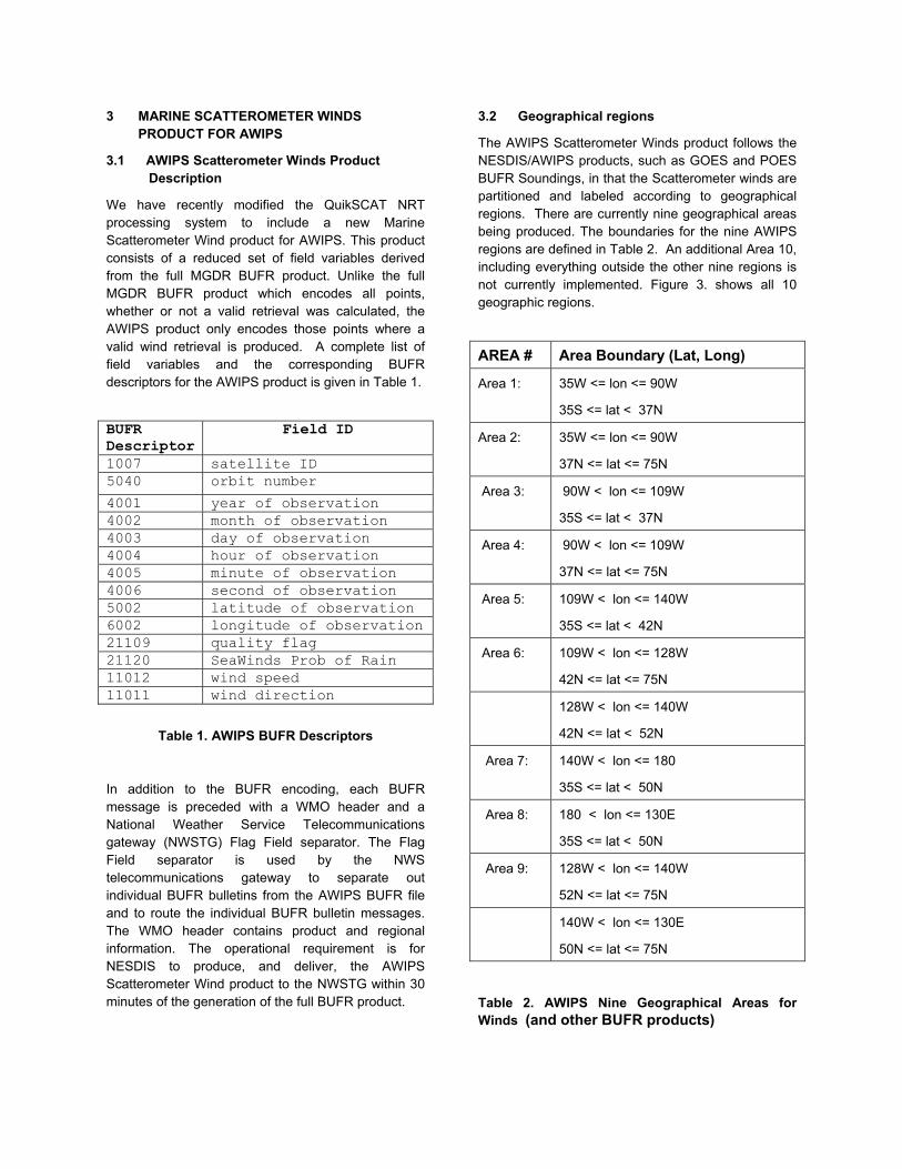
The AWIPS Scatterometer Winds product follows the NESDIS/AWIPS products, such as GOES and POES BUFR Soundings, in that the Scatterometer winds are partitioned and labeled according to geographical regions. There are currently nine geographical areas being produced. The boundaries for the nine AWIPS regions are defined in Table 2. An additional Area 10, including everything outside the other nine regions is not currently implemented. Figure 3. shows all 10 geographic regions.
AREA # Area Boundary (Lat, Long)
Area 1: 35W <= lon <= 90W
35S <= lat < 37N
Area 2: 35W <= lon <= 90W
37N <= lat <= 75N
Area 3: 90W < lon <= 109W
35S <= lat < 37N
Area 4: 90W < lon <= 109W
37N <= lat <= 75N
Area 5: 109W < lon <= 140W
35S <= lat < 42N
Area 6: 109W < lon <= 128W
42N <= lat <= 75N
128W < lon <= 140W
42N <= lat < 52N
Area 7: 140W < lon <= 180
35S <= lat < 50N
Area 8: 180 < lon <= 130E
35S <= lat < 50N
Area 9: 128W < lon <= 140W
52N <= lat <= 75N
140W < lon <= 130E
50N <= lat <= 75N
Table 2. AWIPS Nine Geographical Areas for Winds (and other BUFR products)

As a result of the reduced set of field variables, filtering out points without valid wind retrievals, and regionalization, the size of the AWIPS BUFR product is reduced from approximately 8 Mbytes for the full BUFR product to 200-300 Kbytes for a typical split orbit.
3.3 AWIPS Data Flow
The AWIPS Scatterometer Winds data product produced by NESDIS/IPD consists of one file containing multiple BUFR messages, with appropriate headers, and arranged by region. This product undergoes additional processing after delivery by NESDIS to the NWSTG in order to produce individual BUFR bulletins that are placed on the Satellite Broadcast Network (SBN) Telecommunications Gateway (TG) for transport to the individual AWIPS stations. The AWIPS Scatterometer Winds data flow is described as follows:
1) At NESDIS/IPD: Generation of marine winds vectors based on raw QuikSCAT data and encoded in BUFR format (including all products with appropriate headers: BUFR, WMO, & NWSTG).
2) NESDIS-to-NWSTG transfer
3) NWSTG handling (removal of TG header, routing product to NCF.)
4) NCF handling (receipt from NWSTG, uplink onto the SBN/TG channel.)
5) AWIPS site software for handling these data, including ingest/decode/store/display.
AWIPS display software for the Sactterometer winds is being developed by the NWS Forecast Systems Lab (FSL) in Boulder, CO. Figures 4. and 5. (courtesy of Dale Perry (FSL)) shows some sample screenshots of an AWIPS display with Scatterometer winds data. 4 CONCLUSIONS
QuikSCAT near-real-time processing of SeaWinds data at NOAA/NESDIS has been operational since February 2000. We have successfully added the generation, encoding and transfer of a Marine Scatterometer Winds AWIPS product into the QuikSCAT NRT processing stream. End to end testing has been successful and the AWIPS OB3 software testing continues with the expectation that Scatterometer Winds will be included operationally in the OB3 release scheduled for spring 2004.
SeaWinds ADEOS-II development and testing has taken place and the CAL/VAL period recently concluded. ADEOS-II NRT processing should become operational soon with a second AWIPS data stream to follow shortly. 5 REFERENCES
Augenbaum, J.M., Luczak, R.W. and Legg, G. (2001). “Quikscat Near-Real-Time Data Processing and Product Generation at NOAA/NESDIS”. Proceedings of the 17th International Conference on Interactive Information and Processing Systems (IIPS) for Meteorology, Oceanography, and Hydrology, Albuquerque, New Mexico, pp. 324-328.
Augenbaum, J.M., Luczak, R.W., and Legg, G. (2002). "Recent Developments in QuikSCAT Near-Real-Time Processing at NOAA/NESDIS". Proceedings of the 18th International Conference on Interactive Information and Processing Systems (IIPS) for Meteorology, Oceanography, and Hydrology, Orlando, Florida, pp. 10-12.
Augenbaum, J.M., Luczak, R.W., and Legg, G. (2003). “SEAWINDS NEAR-REAL-TIME PROCESSING AT NOAA/NESDIS: Present Status and Future plans”. Proceedings of the 19th International Conference on Interactive Information and Processing Systems (IIPS) for Meteorology, Oceanography, and Hydrology, Long Beach, California, Combined Preprints CD-ROM.
Hoffman, R.N., and Dunbar, R.S. (2000). “NASA SeaWinds Scatterometer Real-Time Merged Geophysical Data Product (SWS_Met) User's Guide.” Version 2.3.0, Jet Propulsion Laboratory, Pasadena, CA, 45 pages.
Leidner, S.M, Hoffman, R.N., and Augenbaum, J.M., (2000). “SeaWinds Scatterometer Real-Time BUFR Geophysical Data Product User's Guide”. Version 2.3.0, NOAA, Washington, DC, 34 pages.

FIGURE 3. The Ten Geographical Regions for NESDIS BUFR Products in AWIPS

FIGURE 4. Sample screenshot of an AWIPS display with Scatterometer winds data
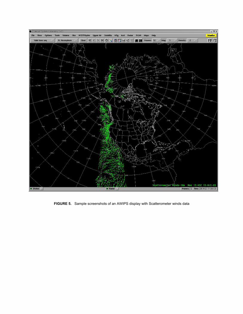
FIGURE 5. Sample screenshots of an AWIPS display with Scatterometer winds data