4-neighborhood park plans - minneapolisparks.org · 61 minneapolis park and recreation board |...
TRANSCRIPT

4PARK PLANS
• INTRODUCTION
• KEY/LEGEND
• PARK PLANS & COST ESTIMATES
SECTION CONTENTS:

This page was intentionally left blank

61
MINNEAPOLIS PARK AND RECREATION BOARD | SOUTH SERVICE AREA MASTER PLAN
PROCESSES
INTRODUCTIONThe South Service Area Master Plan creates unique new designs for 27 of the 32 neighborhood park properties in the service area (the remaining 5 are “special consideration” parks as described on the following page). Those designs appear on the following pages, arranged alphabetically. The plan for each park is displayed as a 6 or 8 page “packet” of information that includes the following:
• A description of the history and current character of the park, along with a location map.
• An aerial photograph of existing conditions at the park, for reference
• A written description of the proposed plan for the park, including some overview of public sentiment during the planning process
• The park plan drawing and key• A matrix showing general input themes and how
• A cost and operations estimate (see chapter 6 for detailed information on cost estimates).
between the existing operational costs and the estimated operational cost .
NOKOMIS/HIAWATHAThe parks surrounding the two recreation centers at Lakes Nokomis and Hiawatha are not included in the South Service Area Master Plan. Though they host neighborhood-type
boundary of Nokomis-Hiawatha Regional Park, for which there is an approved master plan. That Regional Park Master Plan is the guiding document for these park areas.
The neighborhood park plans are concepts. That
Subsequent capital improvement projects will require detailed design processes, and additional community engagement will be performed at that time, per MPRB policy and ACTION 3. The park plans do
benches and signs. Instead, they are a guide to the overall layout of the park and what will be included in the park in the future.
CH 4
| N
EIGH
BORH
OOD
PARK
PLA
NS |
INT
RODU
CTIO
N

62
MINNEAPOLIS PARK AND RECREATION BOARD | SOUTH SERVICE AREA MASTER PLAN
1
2
3
4
5 6
7
30
29
28
26
27
2423
22
21
20
19
18
17
15
16
14
13
12 25
11
10
9
8
Figure 4.1 - Park Location Key
PARKS INCLUDED1. Adams Triangle2. Bossen Field*3. Brackett Field 4. Cedar Avenue Field*5. Central Gym Park6. Corcoran Park7. Currie Park8. Diamond Lake9. East Phillips Park*10. Hiawatha School Park11. Keewaydin Park12. Longfellow Park13. Matthews Park14. McRae Park15. Meridian Garden*16. Morris Park17. Murphy Square18. Normanna Triangle19. Pearl Park
20. Peavey Field Park21. Phelps Field Park22. Phillips Community Center23. Powderhorn Park24. Rollins Triangle*25. Seven Oaks Oval26. Shoreview Triangles (3 park properties)27. Sibley Park28. Solomon Park29. Stewart Park30. Todd Park
* These parks are considered as a part of the overall service area master plan but are considered “special consideration” parks.
* SPECIAL CONSIDERATION PARKSSeveral park properties do not have full packets of information included in the SSAMP document at this time. The reasons for this vary by park and are described in abbreviated park packets appearing in alphabetical sequence with the other parks. Those park properties and the basic reasons for special consideration are:
• Bossen Field: recently master planned independently of the SSAMP.• • East Phillips: community decision to not master plan at this time• Meridian Garden: managed by community group• Rollins Triangle: tiny park triangle impacted by Minnehaha Avenue reconstruction

63
MINNEAPOLIS PARK AND RECREATION BOARD | SOUTH SERVICE AREA MASTER PLAN
PROCESSES
A PARK PLAN DOES DETERMINE• The types and locations of facilities•
landscapes and the general location of trees• The extent and general location of pathways
A PARK PLAN DOES NOT DETERMINE• • The location of minor amenities such as
benches, drinking fountains, and signs
A park plan DOES determine:• That there will be a traditional play area in a certain location in the park (as opposed to a nature play
A park plan DOES NOT determine:• The exact equipment, layout, color, surfacing
Future capital projects will have their own community engagement processes at the time of implementation.
EXAMPLE:
CH 4
| N
EIGH
BORH
OOD
PARK
PLA
NS |
INT
RODU
CTIO
N

64
MINNEAPOLIS PARK AND RECREATION BOARD | SOUTH SERVICE AREA MASTER PLAN
Wading Pool (small, shallow pool for children)
Indoor Swimming Pool
Beach Access
Splash Pad (water play area with sprayers and fountains, with no standing water)
Interactive Water Play (small stream/fountains for kids to play in)
AP AP
AQUATICS PLAY
Traditional Play Structure (swings, slides, climbers)
Adventure Play (place for challenging play for older youth and teens including climbing walls, zip line, obstacle course)
Nature play area (play area for children that encourages creative play with natural materials)
KEY/LEGEND
SD SD
ATHLETICS
Multi-use Field (open turf that may be used for soccer or other sports)
Multi-use Diamond for baseball or softball
used for soccer or other sports)
Premier Field (High
other sports, often with permanent stripes
Premier Diamond (High
or softball, usually with a fence around the
Sports Dome (may be put up in winter to allow sports to be played year round)
Places to play in the water (swimming, splash pads)
Places for youth to play (swings, slides, vertical climbings walls)
MC MC
COURTS
Tennis Court
Basketball Court
Volleyball Court
Multi-sport Court (court striped to allow many
pickleball, bike polo)
Sports on hard surface courts

65
MINNEAPOLIS PARK AND RECREATION BOARD | SOUTH SERVICE AREA MASTER PLAN
CH 4
| N
EIGH
BORH
OOD
PARK
PLA
NS |
KEY
/ LEG
END
WINTER USE
Designated Sledding Hill
Skating Rink
Broomball Rink
Hockey Rink
Year-round Rink (Hard-surface rink for hockey all year or bike polo in summer)
Warming House
LANDSCAPE
Outdoor Gathering Space (Open area for community gathering/picnics)
Designated Urban Agriculture Area
Mown Turf Grass
(native vegetation areas,
YR YR
Places to play in winter (ice skating, sledding)
OTHEROther types of recreation in outdoor parks
Group Shelter
Stage / Bandshell (for outdoor plays, music, or classes)
Adult Fitness (area with machines to work out in)
Walking Loop Trail (walking path that loops around the park, includes signs and seating)
Lawn/Court Games (small open lawn or court for games)
Dog Park
Disc Golf
Archery (archery course)
Skate Park
Canoe/Kayak Launch
Community Oven
Restroom/Storage Building
LG LG

This page was intentionally left blank

171
MINNEAPOLIS PARK AND RECREATION BOARD | SOUTH SERVICE AREA MASTER PLAN
CH 4
| N
EIGH
BORH
OOD
PARK
PLA
NS |
PEA
RL
LOCATION AND HISTORY Pearl Park is one of the larger parks in the south service area. It is located just north of Diamond Lake and stretches for three long blocks on the west side of Portland Avenue. Unlike most south service area parks it is not a square, but rather a somewhat irregular rectangle bounded by streets that wiggle as they traverse the city north to south. This shape has much to do with the park’s history.
board in 1923 from Clarke’s Diamond Lake Realty to donate a tract of land “surrounding Pearl Lake and a portion of the shores of Diamond Lake” for park
purposes—a donation that was accepted in 1925. In the 1927 annual report, park superintendent Theodore
Lake. While the plans to dredge Diamond Lake never
there in the winter of 1929-1930.
The Pearl Lake and Diamond Lake Park holdings increased dramatically in 1936 with the acquisition of 72.32 acres (of mostly water). The park board conducted studies with the community on development of Pearl Lake as a community park and regional athletic
dumped and graded well more than 75,000 cubic
the airport, where federal crews were grading for new runways. (The park board owned the airport at the time and was responsible for its development and operation until the 1940s.) The crews then built a skating rink;
a volleyball court; and horseshoe pits. A children’s playground was also installed.
In 1962, the board included Pearl in its capitol improvement program for 1965, but added that the
Lake, like most other parks in the system built on
to the west. The 1965 plan for the park positioned a proposed recreation center at the south end of the park instead of in the center of the park as earlier plans had done. Work to execute those plans began in 1966, primarily grading and landscaping, and were continued the next year with work on the new recreation center,
throughout the park.
The new recreation center was dedicated in December, 1968—the costs split in half between assessments on neighborhood property and city bonds. As a park
included chunks of concrete that migrated to the surface over time.
PEARL The old recreation center was renovated and a gym added in 1996. In 2008 the wading pool at the park was upgraded to meet new safety standards. In 2011
remediation of poor soil. In 2015 the basketball and volleyball courts were resurfaced, and a new youth-
EXISTING CONDITIONS AND CHARACTER
four sections, arranged from south to north. The southernmost section is home to the recreation center, two play areas, a wading pool, and various courts: basketball, tennis, and volleyball. A parking lot along Diamond Lake Road includes permeable paving as
before it enters Diamond Lake.
Just to the north of the recreation center is quad of multi-use diamonds arranged facing inward toward
skating area and hockey rink in the winter. Immediately to the north of this multi-use complex is a premier baseball diamond and associated batting cages and concession building. The northernmost section of the
Paths encircle the southern three sections of the park but end at East 53rd Street just north of the premier baseball diamond.
Pearl Park feels quite large, as south Minneapolis parks go, especially with the feeling of open space continuing southward as Diamond Lake Park. This is an active park, with many sports leagues—operated both by MPRB and others—occupying all sections of the park throughout the playing season. It also feels more pastoral than other parks, because it is not a square in the city grid, but rather retains shades of its watery past.

172
MINNEAPOLIS PARK AND RECREATION BOARD | SOUTH SERVICE AREA MASTER PLAN
UPDATE EXISTINGUUUUUUUUUUUUUUUUUUUUUUUUUUUUUUUUUUUUUUUUUUUUUUUUUUUUUUUUUUUUUUUUUUUUUUUUUUUUUUUUUUUUUUUUUUUUUUUUUUUUUUUUUUUUUUUUUUUUUUUUUUUUUUUUUUUUUUUUUUUUUUUUUUUUUUUUUUUUUUUUUUUUUUUUUUUUUUUUUUUUUUUUUUPPPPPPPPPPPPPPPPPPPPPPPPPPPPPPPPPPPPPPPPPPPPPPPPPPPPPPPPPPPPPPPPPPPPPPPPPPPPPPPPPPPPPPPPPPPPPPPPPPPPPPPPPPPPPPPPPPPPPPPPPPPPPPPPPPPPPPPPPPPPPPPPPPPPPPPPPPPPPPPPPPPPPPPPPPPPPPPPPPPPPPPPPPPPPPPPPPPPPPPPPPPPPPPPPPPPPPPPPPPPPPPPDDDDDDDDDDDDDDDDDDDDDDDDDDDDDDDDDDDDDDDDDDDDDDDDDDDDDDDDDDDDDDDDDDDDDDDDDDDDDDDDDDDDDDDDDDDDDDDDDDDDDDDDDDDDDDDDDDDDDDDDDDDDDDDDDDDDDDDDDDDDDDDDDDDDDDDDDDDDDDDDDDDDDDDDDDDDDDDDDDDDDDDDDDDDDDDDDDDDDDDDDDDDDDDDDDDDDDDDDDDDDDDDDDDDDDDDDDDDDDDDDDDDDDDAAAAAAAAAAAAAAAAAAAAAAAAAAAAAAAAAAAAAAAAAAAAAAAAAAAAAAAAAAAAAAAAAAAAAAAAAAAAAAAAAAAAAAAAAAAAAAAAAAAAAAAAAAAAAAAAAAAAAAAAAAAAAAAAAAAAAAAAAAAAAAAAAAAAAAAAAAAAAAAAAAAAAAAAAAAAAAAAAAAAAAAAAAAAATTTTTTTTTTTTTTTTTTTTTTTTTTTTTTTTTTTTTTTTTTTTTTTTTTTTTTTTTTTTTTTTTTTTTTTTTTTTTTTTTTTTTTTTTTTTTTTTTTTTTTTTTTTTTTTTTTTTTTTTTTTTTTTTTTTTTTTTTTTTTTTTTTTTTTTTTTTTTTTTTTTTTTTTTTTTTTTTTTTTTTTTTTTTTTTTTTTTTTTTTTTTTTTTTTTEEEEEEEEEEEEEEEEEEEEEEEEEEEEEEEEEEEEEEEEEEEEEEEEEEEEEEEEEEEEEEEEEEEEEEEEEEEEEEEEEEEEEEEEEEEEEEEEEEEEEEEEEEEEEEEEEEEEEEEEEEEEEEEEEEEEEEEEEEEEEEEEEEEEEEEEEEEEEEEEEEEEEEEEEEEEEEEEEEEEEEEEEEEEEEEEEEEEEEEEEEEEEEEEEEE EEEEEEEEEEEEEEEEEEEEEEEEEEEEEEEEEEEEEEEEEEEEEEEEEEEEEEEEEEEEEEEEEEEEEEEEEEEEEEEEEEEEEEEEEEEEEEEEEEEEEEEEEEEEEEEEEEEEEEEEEEEEEEEEEEEEEEEEEEEEEEEEEEEEEEEEEEEEEEEEEEEEEEEEEEEEEEEEEEEEEEEEEEEEEEEEEEEEEEEEEEEEEEEEEEEEEEEEEEEEEEEEEEEEEEEEEEEEEEEEEEEEEEEEEEEEEEEEEEEEEEEEEEEEEEEEEEEEEEEEEEEEEEEEEEEEEEEEEEEEEEEEEEXXXXXXXXXXXXXXXXXXXXXXXXXXXXXXXXXXXXXXXXXXXXXXXXXXXXXXXXXXXXXXXXXXXXXXXXXXXXXXXXXXXXXXXXXXXXXXXXXXXXXXXXXXXXXXXXXXXXXXXXXXXXXXXXXXXXXXXXXXXXXXXXXXXXXXXXXXXXXXXXXXXXXXXXXXXXXXXXXXXXXXXXXXXXXXXXXXXXXXXXXXXXXXXXXXXXXXXXXXXXXXXXXXXXXXXXXXXXXXXXXXXXXXXXXXXXXXXXXXXXXXXXXXXXXXIIIIIIIIIIIIIIIIIIIIIIIIIIIIIIIIIIIIIIIIIIIIIIIIIIIIIIIIIIIIIIIIIIIIIIIIIIIIIIIIIIIIIIIIIIIIIIIIIIIIIIIIIIIIIIIIIIISSSSSSSSSSSSSSSSSSSSSSSSSSSSSSSSSSSSSSSSSSSSSSSSSSSSSSSSSSSSSSSSSSSSSSSSSSSSSSSSSSSSSSSSSSSSSSSSSSSSSSSSSSSSSSSSSSSSSSSSSSSSSSSSSSSSSSSSSSSSSSSSSSSSSSSSSSSSSSSSSSSSSSSSSSSSSSSSSSSSSSSSSSSSSSSSSSSSSSSSSSSSSSSSSSSSSSSSSSSSSSSSSSSSSSSSSSSSSSSSSSSSSSSSSSSSSSSSSSSSSSSSSSSSSSSSSSTTTTTTTTTTTTTTTTTTTTTTTTTTTTTTTTTTTTTTTTTTTTTTTTTTTTTTTTTTTTTTTTTTTTTTTTTTTTTTTTTTTTTTTTTTTTTTTTTTTTTTTTTTTTTTTTTTTTTTTTTTTTTTTTTTTTTTTTTTTTTTTTTTTTTTTTTTTTTTTTTTTTTTTTTTTTTTTTTTTTTTTTTTTTTTTTTTTTTTTTTTTTTTTTTTTTTTTTTTTTTTTTTTTTTTTTTTTTTTTTTTTTTTTTTTTTTTTTTTTIIIIIIIIIIIIIIIIIIIIIIIIIIIIIIIIIIIIIIIIIIIIIIIIIIIIIIIIIIIIIIIIIIIIIIIIIIIIIIIIIIIIIIIIIIIIIIIIIIIIIIINNNNNNNNNNNNNNNNNNNNNNNNNNNNNNNNNNNNNNNNNNNNNNNNNNNNNNNNNNNNNNNNNNNNNNNNNNNNNNNNNNNNNNNNNNNNNNNNNNNNNNNNNNNNNNNNNNNNNNNNNNNNNNNNNNNNNNNNNNNNNNNNNNNNNNNNNNNNNNNNNNNNNNNNNNNGGGGGGGGGGGGGGGGGGGGGGGGGGGGGGGGGGGGGGGGGGGGGGGGGGGGGGGGGGGGGGGGGGGGGGGGGGGGGGGGGGGGGGGGGGGGGGGGGGGGGGGGGGGGGGGGGGGGGGGGGGGGGGGGGGGGGGGGGGGGGGGGGGGGGGGGGGGGGGGGGGGGGGGGGGGGGGGGGGGGGGGGGGGGGGGGGGGGGGGGG
Existing Conditions: Pearl

173
MINNEAPOLIS PARK AND RECREATION BOARD | SOUTH SERVICE AREA MASTER PLAN
PORTLAND AVE S
E DI
AMON
D LA
KE R
D
0’ 40’ 80’ 160’
LG
NEW/ ADDED Premier Field
Adult Fitness
Tennis Court
Storage Building
Walking Loop Trail
Proposed Plan: Pearl
CH 4
| N
EIGH
BORH
OOD
PARK
PLA
NS |
PEA
RL

174
MINNEAPOLIS PARK AND RECREATION BOARD | SOUTH SERVICE AREA MASTER PLAN
UPDATE EXISTING
Traditional Play Structure
Wading Pool
Basketball Court
Volleyball Court
Multi-use Field
Multi-use Diamond
Premier Diamond
Tennis Court
Skating Rink
Hockey Rink
Lawn/Court Games
Designated Sledding Hill
LG
CONNECTIONS BETWEEN PARKS
focus on:
• The existing City of Minneapolis bicycle and pedestrian route on 54th Street, which connects to Nokomis-Hiawatha Regional Park
• Improved crossings of Portland Avenue and 52nd, 53rd, and 54th Streets
• Implementation of the proposed Southside Greenway, a community and City of Minneapolis project running on Portland Avenue and connecting all the way through the south service area.
THE PROPOSED DESIGNMany facilities in Pearl Park are relatively new, so the plan does not change the fundamental arrangement of the park. The four general sections remain, with the
premier baseball diamond) essentially unchanged. The
the facilities near the recreation center are likewise retained in their current locations—playgrounds, wading pool, parking lot, lawn games area, and basketball and volleyball court. The main change in this area is the addition of two additional tennis courts (arranged north-south), to consolidate tennis in this park in light of the removal of tennis at Todd and other SSA parks. The tennis area can be expanded while still preserving space for sledding on the east facing hillside.
northern half improved but retained as a multi-use
be along Portland Avenue and in the surrounding neighborhoods, as it is today, but crosswalks and trail connections would be improved to increase safety and accessibility.
At the northernmost edge of the park, hidden from views along Portland by existing trees and new screening, is a small maintenance building and yard. This maintenance area provides necessary equipment and materials staging for Pearl and other nearby parks,
side parks. This building will not be open to the public. Restroom facilities will be handled as they are today, with portable toilets between the soccer and baseball areas.
friendly plantings, and additional trails reach into and around the northern section of the park, providing more neighborhood connections and walking loops. Pearl Park will keep its sports focus by providing the same
support. But Pearl will at the same time become more natural and idyllic, encouraging strolls around the edges along with sports in the center.
KNOWN LAND USE AND COORDINATION ITEMSThere are no known land use issues at Pearl Park.

175
MINNEAPOLIS PARK AND RECREATION BOARD | SOUTH SERVICE AREA MASTER PLAN
PROCESSES
CH 4
| N
EIGH
BORH
OOD
PARK
PLA
NS |
PEA
RL
1: General Input2: Initial Concepts + Public Comment 3: The Preferred Concept
Spring-Fall 2015 Fall-Winter-Summer 2015/2016 Now
aqua
tics Pool mostly seen as negative,
probably because of quality; bigger, deeper pool desired
no comments Wading pool in same general location
play Play area needs improvement, but is
well likedno comments Play area in same general location
Provide more challenging options for older kids
Diamonds and fields liked about the same, but need improvement
Maximize soccer fields; like premier fields in northern end, but keep six youth fields overall
Premier diamond in center of park, as existing
Keep four diamonds hereMulti-use field and diamond area in south end of park, as existing
Some concern about premier field, mainly about who can use it
Addition of premier soccer field in northern end of park, at a size to accommodate three youth fields or one adult field, with an adjacent multi-use field that can accommodate three youth fields
cour
ts
Tennis courts well liked Need to upgrade basketball courtAddition of two tennis courts, for a total of four (retains sledding area)
Basketball court in same general location
Sand volleyball court instead of hard court, in same general locationEnhanced lawn/court games area (bocce, lawn bowling, bag toss, etc.) in location of existing horseshoes
win
ter Move hockey off of multi-use fields
into open area behind buildingno comments
Hockey rink and open skating area on multi-use fields, as existing
athl
etic
s
Basketball courts need improvement, but basketball is a desired activity
176
MINNEAPOLIS PARK AND RECREATION BOARD | SOUTH SERVICE AREA MASTER PLAN
PROCESSES CONT.
1: General Input2: Initial Concepts + Public Comment 3: The Preferred Concept
Spring-Fall 2015 Fall-Winter-Summer 2015/2016 Now
land
scap
e
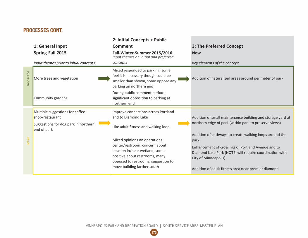
More trees and vegetation
Mixed responded to parking: some feel it is necessary though could be smaller than shown, some oppose any parking on northern end
Addition of naturalized areas around perimeter of park
Community gardensDuring public comment period: significant opposition to parking at northern end
Multiple suggestions for coffee shop/restaurant
Improve connections across Portland and to Diamond Lake
Suggestions for dog park in northern end of park
Like adult fitness and walking loop
Addition of pathways to create walking loops around the park
Enhancement of crossings of Portland Avenue and to Diamond Lake Park (NOTE: will require coordination with City of Minneapolis)
Addition of adult fitness area near premier diamond
othe
r
Addition of small maintenance building and storage yard at northern edge of park (within park to preserve views)
Mixed opinions on operations center/restroom: concern about location in/near wetland, some positive about restrooms, many opposed to restrooms, suggestion to move building farther south

177
MINNEAPOLIS PARK AND RECREATION BOARD | SOUTH SERVICE AREA MASTER PLAN
CH 4
| N
EIGH
BORH
OOD
PARK
PLA
NS |
PEA
RL
COST ESTIMATE
Asset Type Project 2017 ESTIMATED
COST/PROJECT Implementation Sequence Prioritization
Category Applicable SSAMP
Actions
AquaticsWading Pool,
739,226$ PLANNED 16 Play Traditional Play Structures (2) in new container 698,158$ FUNDED 16, 23b, 23d
AthleticsAthletic field renovation, southern:
2,792,633$ PLANNED 16, 21b
AthleticsAthletic field renovation, central:
665,304$ PLANNED 16, 21b
Athletics
Athletic field renovation, northern:
2,266,961$ PLANNED 16, 21b, 21c, 21fCourts Tennis Court (4) 427,109$ PLANNED 16 Courts Basketball Court 106,777$ PLANNED 16, 22aCourts Volleyball Court 57,495$ PLANNED 16
Landscape Naturalized areas 308,096$ PLANNED 25, 26, 29Landscape Existing parking lot renovation 430,207$ PLANNED 28 Other Adult Fitness 150,894$ PLANNED 16, 18Other Maintenance /Restroom Building and Yard 1,070,630$ PLANNED 14 Other Renovate walking paths 657,090$ PLANNED 10, 16, 17Other Improved crossings of Portland Avenue -$ CONTINGENT 8
Other Miscl. signs, trees, furniture 166,638$ PLANNED 9, 10, 17
TOTAL 10,537,216$

178
MINNEAPOLIS PARK AND RECREATION BOARD | SOUTH SERVICE AREA MASTER PLAN
OPERATIONS ESTIMATE
179
MINNEAPOLIS PARK AND RECREATION BOARD | SOUTH SERVICE AREA MASTER PLAN
CH 4
| N
EIGH
BORH
OOD
PARK
PLA
NS |
PEA
VEY
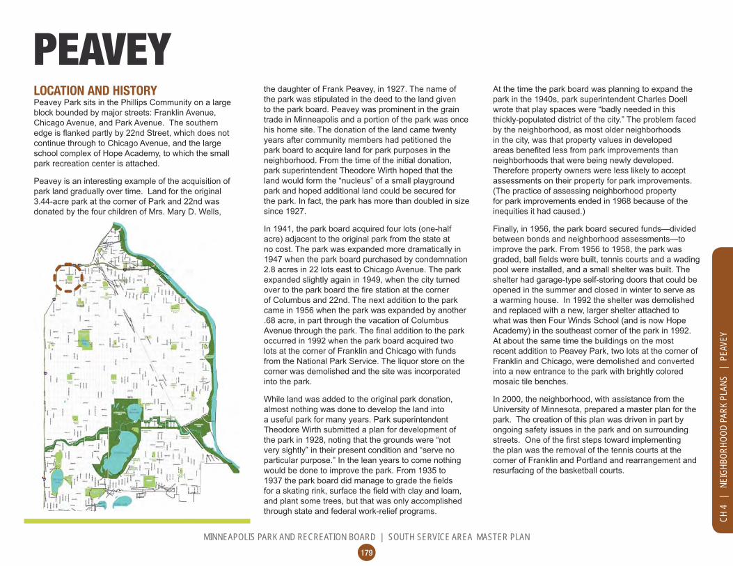
LOCATION AND HISTORY Peavey Park sits in the Phillips Community on a large block bounded by major streets: Franklin Avenue, Chicago Avenue, and Park Avenue. The southern
continue through to Chicago Avenue, and the large school complex of Hope Academy, to which the small park recreation center is attached.
Peavey is an interesting example of the acquisition of park land gradually over time. Land for the original 3.44-acre park at the corner of Park and 22nd was donated by the four children of Mrs. Mary D. Wells,
the daughter of Frank Peavey, in 1927. The name of the park was stipulated in the deed to the land given to the park board. Peavey was prominent in the grain trade in Minneapolis and a portion of the park was once his home site. The donation of the land came twenty years after community members had petitioned the park board to acquire land for park purposes in the neighborhood. From the time of the initial donation, park superintendent Theodore Wirth hoped that the land would form the “nucleus” of a small playground park and hoped additional land could be secured for
since 1927.
In 1941, the park board acquired four lots (one-half acre) adjacent to the original park from the state at no cost. The park was expanded more dramatically in 1947 when the park board purchased by condemnation 2.8 acres in 22 lots east to Chicago Avenue. The park expanded slightly again in 1949, when the city turned
of Columbus and 22nd. The next addition to the park came in 1956 when the park was expanded by another .68 acre, in part through the vacation of Columbus
occurred in 1992 when the park board acquired two lots at the corner of Franklin and Chicago with funds from the National Park Service. The liquor store on the corner was demolished and the site was incorporated into the park.
While land was added to the original park donation, almost nothing was done to develop the land into a useful park for many years. Park superintendent Theodore Wirth submitted a plan for development of the park in 1928, noting that the grounds were “not very sightly” in their present condition and “serve no particular purpose.” In the lean years to come nothing would be done to improve the park. From 1935 to
and plant some trees, but that was only accomplished through state and federal work-relief programs.
PEAVEYAt the time the park board was planning to expand the park in the 1940s, park superintendent Charles Doell wrote that play spaces were “badly needed in this thickly-populated district of the city.” The problem faced by the neighborhood, as most older neighborhoods in the city, was that property values in developed
neighborhoods that were being newly developed. Therefore property owners were less likely to accept assessments on their property for park improvements. (The practice of assessing neighborhood property for park improvements ended in 1968 because of the inequities it had caused.)
Finally, in 1956, the park board secured funds—divided between bonds and neighborhood assessments—to improve the park. From 1956 to 1958, the park was
pool were installed, and a small shelter was built. The shelter had garage-type self-storing doors that could be opened in the summer and closed in winter to serve as a warming house. In 1992 the shelter was demolished and replaced with a new, larger shelter attached to what was then Four Winds School (and is now Hope Academy) in the southeast corner of the park in 1992. At about the same time the buildings on the most recent addition to Peavey Park, two lots at the corner of Franklin and Chicago, were demolished and converted into a new entrance to the park with brightly colored mosaic tile benches.
In 2000, the neighborhood, with assistance from the University of Minnesota, prepared a master plan for the park. The creation of this plan was driven in part by ongoing safety issues in the park and on surrounding
the plan was the removal of the tennis courts at the corner of Franklin and Portland and rearrangement and resurfacing of the basketball courts.

180
MINNEAPOLIS PARK AND RECREATION BOARD | SOUTH SERVICE AREA MASTER PLAN
PROCESSES
EXISTING CONDITIONS AND CHARACTERPeavey Park has a fairly typical suite of park amenities.
its corners occupies the southwestern quadrant of the
provides access to a wading pool, playgrounds, and basketball courts. The basketball area features three half-courts arranged in a triangle with backboards on the outer edges. The eastern edge of the park features
gathering space on the corner of Franklin and Chicago, one of the busiest intersections in the service area.
Safety concerns continue at Peavey Park. Lighting exists throughout the park and is left on all night. The feeling in the neighborhood is that Peavey neither meets the needs of the surrounding area nor serves as a destination park like some others in the system. It therefore fails to attract as heavy use as might be expected in such a dense neighborhood. The community-prepared master plan, which formed the basis for the SSAMP plan, strives to remake the park to accomplish these goals.
CONNECTIONS BETWEEN PARKS
focus on:
• The existing City of Minnepolis bicycle/pedestrian routes on Park Avenue and 24th Street (just south of the park), which connect Peavey to the Phillips Pool and East Phillips park

181
MINNEAPOLIS PARK AND RECREATION BOARD | SOUTH SERVICE AREA MASTER PLAN
CH 4
| N
EIGH
BORH
OOD
PARK
PLA
NS |
PEA
VEY
Existing Conditions: Peavey

182
MINNEAPOLIS PARK AND RECREATION BOARD | SOUTH SERVICE AREA MASTER PLAN
LG
0’ 20’ 40’ 60’
CHICAGO AVE S
PARK AVE
E 22ND STProposed Plan: Peavey

183
MINNEAPOLIS PARK AND RECREATION BOARD | SOUTH SERVICE AREA MASTER PLAN
CH 4
| N
EIGH
BORH
OOD
PARK
PLA
NS |
PEA
VEY
UPDATE EXISTING
Traditional Play Structure
Basketball Court
Multi-use Field
Outdoor Gathering Space
Group Shelter
Interactive Water Play
Walking Loop Trail
Skating Rink
Lawn/Court Games
Urban Agriculture Area
Basketball Court
LG
NEW/ ADDED
THE PROPOSED DESIGNPeavey is one of few parks in the SSAMP (along with Currie Park), which will see a nearly complete overhaul. In fact, the only element to remain in the Peavey park plan is the public art gathering space on the northeast corner of the park. The plan draws heavily from the master plan prepared by the community and the University of Minnesota in 2000, but makes some
the community during the SSAMP planning process. Every move in the plan is designed to increase activity, improve visibility, and strike a balance between sports and passive use.
stretching from the north center edge of the park to the southeastern corner. This promenade will feel like a grand pedestrian avenue, possibly with benches and high-quality pavement. As the main entry and circulation route through the park—as well as a place to encounter neighbors and gather for conversation—it should communicate the welcoming nature of the park, as well as reinforce the excitement and potential of the surrounding neighborhood. Circling the park and intersecting with the promenade are two rings of pathways that undulate through natural areas, gardens, and shady woods. One ring is entirely paved, while the other is partly aggregate surfacing, to create a variety of experiences.
Arranged among these paths are a variety of active and passive recreation opportunities. A new recreation center-like building anchors the southern edge of the
the park and serve as a destination to draw people in from the street into the interior of the park. The building should be integrated with the site, as an indoor/outdoor space with opportunities for gathering. Just west of the building is a lawn games area that could be used for
skating.
In front of the building, angled to follow the promenade,
games or any other combination of youth games and
its edges. In the northwestern corner of the park are two full-court basketball courts, one half-court, and a shooting practice hoop. Inclusion of full court basketball is a departure fro existing conditions and from the 2000 master plan, but it was held up as a critical need by the community. The new basketball complex provides varied options for playing and practicing the sport with high visibility from the streets.
East of the promenade are play areas, a group shelter, a community orchard, and an interactive water feature that serves as both play feature and activating element in the park. The water feature is the only aquatic
wading pools are available in parks in fairly close proximity). The element could feature programmable jets with lighting, or could be integrated into the design of the play areas to allow for creative play with water.
plantings are kept low in height and the trees are pruned up, this planting scheme will provide good visibility into the park while also creating a real edge between the recreation space and the surrounding streets. By building on previous community planning
SSAMP process, the plan for Peavey Park envisions a destination park that is active, vibrant, lush, exciting, and safe.
KNOWN LAND USE AND COORDINATION ISSUESThere are no known land use or coordination issues with Peavey Park.
The current recreation building sits on land owned by Hope Academy. The outcomes of RecQuest will
centers in the system as a whole, including at Peavey, at which time discussions with Hope Academy will be necessary.

184
MINNEAPOLIS PARK AND RECREATION BOARD | SOUTH SERVICE AREA MASTER PLAN
PROCESSES
1: General Input 2: Initial Concepts 3: The Preferred ConceptSpring-Fall 2015 Fall-Winter 2015/2016 Now
aqua
tics Mixed opinions on wading pool:
suggestion for splash pad, desire for supervision
Like the interactive water play areaInteractive water play areas in several locations instead of single wading pool (can function as plazas and activate the whole park space)
play Play areas almost universally disliked,
due to lack of shade and disrepairPlay areas not shown large enough in the concepts
Play areas located in eastern portion of park, along main walkway
athl
etic
s Significant preference for multi-use fields over diamonds, though fields need improvement
Athletic field improvements should accommodate an adult-size soccer field
Large multi-use field space west of main walkway, able to accommodate adult soccer and multiple youth fields (no diamonds planned for this park)
Full court basketball is needed in this park, though it is shown too close to kids play areas
Basketball courts reconfigured in northwest corner of park, to include two full courts, one half court, and a warm-up hoop
Suggestion that the skating rink double as a bocce court in the summer
Addition of bocce and lawn games area that can be flooded in winter for skating
win
ter Include winter skating in park for
learners, with boardsLike having the skating rink, but many kids don't have skates
Addition of winter skating rink adjacent to park building
cour
ts Basketball is really big in this park; full courts would be preferred over half

185
MINNEAPOLIS PARK AND RECREATION BOARD | SOUTH SERVICE AREA MASTER PLAN
CH 4
| N
EIGH
BORH
OOD
PARK
PLA
NS |
PEA
VEY
PROCESSES CONT.
1: General Input 2: Initial Concepts 3: The Preferred ConceptSpring-Fall 2015 Fall-Winter 2015/2016 Now
Use the previous University of Minnesota design concept as the basis for the plan
Like that both concepts generally follow University plan, but general preference for "B" showing building on southern edge
Park design follows general concept prepared by the neighborhood and the University of Minnesota, organized around high-activity diagonal walkway connecting Franklin and Chicago
Community gardens and natural areas Like food forest / orchardAddition of urban agriculture areas in several locations, including an orchard / food forest
More trees and shadeConcern about number of trees shown on the perimeter, could reduce visibility into park
Addition of naturalized areas and gardens throughout the park
SAFETY is the number one concern in the park: want more officer foot patrols, more activity, more visibility, more lighting
Addition of park building, conceived as a public/private partnership to activate the park and improve safety through "eyes on the park"
Like picnic area with grills; expand it
Addition of a group picnic shelter along the main walkway near the orchard
Public art at the Franklin and Chicago corner, as existing
othe
r
Addition of interconnected walking loops and plazas of different types: an active community gathering plaza around the building, a paved walking trail looping around the park, a soft surface trail looping around the park, and interactive water feature plazas in several locations
land
scap
e
Significant positive opinion of public art on corner of Chicago and Franklin, but in need of refurbishment
Placing the new building or a pergola along Franklin will block views into the park and create a safety issue; prefer building located to south edge of park

186
MINNEAPOLIS PARK AND RECREATION BOARD | SOUTH SERVICE AREA MASTER PLAN
OPERATIONS ESTIMATE
COST ESTIMATE
Asset Type Project 2017 ESTIMATED
COST/PROJECT Implementation Sequence Prioritization
Category Applicable SSAMP
Actions
Aquatics Interactive Water feature 369,613$ PLANNED 16, 20a, 20b
Play Traditional Play Structures (2) in new container 698,158$ FUNDED/PLANNED 16, 23b, 23d
AthleticsAthletic field renovation,
624,236$ FUNDED/PLANNED 16, 21a, 21bCourts Basketball Court 279,263$ PLANNED 16, 22a
Landscape Urban Agriculture Area -$ CONDITIONAL 19 Landscape Naturalized areas 58,600$ PLANNED 26, 29
OtherRenovate public art/plaza
-$ PLANNED 16 Other Group picnic shelter 90,350$ PLANNED 16, 18Other Lawn games/skating area 73,923$ PLANNED 16, 18, 24
Other Community Center, 3,585,247$ CONDITIONAL 16 Other Renovate walking paths 752,762$ PLANNED 16, 17Other Miscl. signs, trees, furniture 77,287$ PLANNED 9, 17
TOTAL 6,609,439$
NOTE: Urban Agriculture Areas will be implemented in
The renovation of the public art/plaza on the corner of Chicago will be the responsibility of City of Minneapolis public art program. Implementation of new recreation center depends on

187
MINNEAPOLIS PARK AND RECREATION BOARD | SOUTH SERVICE AREA MASTER PLAN
CH 4
| N
EIGH
BORH
OOD
PARK
PLA
NS |
PHE
LPS
LOCATION AND HISTORY Phelps Field Park occupies a large city block bounded by 39th Street, Chicago Avenue, 40th Street, and Park Avenue. It is a park-in-a-bowl, like Sibley, with its northern edge being at street level and its southern side below surrounding streets.
The park was purchased in 1917, concluding a year of activism by residents in the vicinity of the park to have a
assessed for the cost of the land and would not to ask
years. They volunteered to make improvements in the interim at their own expense under the supervision of the park superintendent.
PHELPS The 1917 annual report included a grand and detailed
in what Theodore Wirth called a “rapidly growing section of the city.” The plan was to develop the space primarily for athletic use, on three levels or terraces, but it still
Wirth even had a scale model created of his plan. The most interesting aspect of the plan was Wirth’s
wing for a gymnasium and another for an assembly
national “social center” movement of the time in parks around the country. Wirth’s explanation of his plan
be more than a playground and neighborhood park,” he wrote, “it will be the meeting place at all times of the year for the people who are interested in the doings and welfare of their children, the development of the district in which they live, the advancement of the city as a whole, and, in fact, everything that tends toward the furthering of the community’s progress and a neighborly spirit of good-fellowship.”
Perhaps the plan was too grand, and too expensive for property owners to pay for. In 1922 Wirth presented a
report then that he regretted the high cost of his earlier plan, which he attributed to the topography of the land.
facilities as the original plan, but the social center was missing; instead “an ordinary shelter is substituted.”
The improvements to Phelps Field Park were 85% completed by the end of 1924. A small remaining balance in the fund from assessments for the park was used in 1934 to construct a concrete wading pool and cement walks around it. The park was named for park commissioner Edmund J. Phelps in 1939. Phelps was a park commissioner from 1905 until he died in 1923. He was president of the park board in 1912 and 1913.
areas around the wading pool. A new recreation center was built at Phelps in 1969, at the beginning of MPRB’s city-wide buildings program. Once again the original plans for the recreation building at the park were scaled
park board had ended the policy of assessing property owners for park improvements, but that created new problems. With improvements at all parks being paid for by city bonds, the park board had to balance demands from around the city for those funds. In this instance, the board approved more expensive plans for larger recreation centers at Sibley and Nicollet (King) parks, east and west respectively from Phelps Field in south Minneapolis, which required a cutback in the amount that could be spent at Phelps.
Those reductions were made later when the park board added a gym to the building at Phelps and renovated the park in 1993-1994. The funds for the project came from many sources and led to a new operating agreement with the Boys and Girls Club, which manages the building to this day. In 2010 two baseball
Community Fund and The Toro Company.
EXISTING CONDITIONS AND CHARACTER
use diamonds in the northeastern and northwestern
space. The building, currently operated by the Boys and Girls Club, is located at the northeastern corner of the park. To the east of the building, sandwiched between the building wall and the rising slope up to Chicago Avenue, is a secluded pair of half-court basketball courts.
Arranged along 39th Street west of the building are a wading pool, play areas, a small picnic area, and a tennis court. A small parking lot is accessible from 39th Street. A pathway runs around the outside of the
surrounding sidewalks. This feature is rather unique to Phelps, and provides good accessibility into the park even with the challenges of the grade.
Though MPRB does not have a recreation center presence in the park, it is nevertheless very active because of the Boys and Girls Club. The park is situated among busy streets but feels quiet and peaceful because of its location many feet lower than those streets.

188
MINNEAPOLIS PARK AND RECREATION BOARD | SOUTH SERVICE AREA MASTER PLAN
UPDATE EXISTINGUUUUUUUUUUUUUUUUUUUUUUUUUUUUUUUUUUUUUUUUUUUUUUUUUUUUUUUUUUUUUUUUUUUUUUUUUUUUUUUUUUUUUUUPPPPPPPPPPPPPPPPPPPPPPPPPPPPPPPPPPPPPPPPPPPPPPPPPPPPPPPPPPPPPPPPPPPPPPPPPPPPPPPPPPPPPPPPPPPPPPPPPPPPPPPPPPPPPPPPPPPPPPDDDDDDDDDDDDDDDDDDDDDDDDDDDDDDDDDDDDDDDDDDDDDDDDDDDDDDDDDDDDDDDDDDDDDDDDDDDDDDDDDDDDDDDDDDDDDDDDDDDDDDDDDDDDDDDDDDDDDDDDDDDDDDDDDDDDDDDDDDDDDDDDDDDDDDDDDAAAAAAAAAAAAAAAAAAAAAAAAAAAAAAAAAAAAAATTTTTTTTTTTTTTTTTTEEEEEEEEEEEEEEEEEE EEEEEEEEEEEXXXXXXXXXXXXXXXXXXXXXXXXXXXXXXXXXXXXXXIIIIIIIIIIIIIIIIIIIISSSSSSSSSSSSSSSSSSSSSSSSSSSSSSSSSSSSSSSSSSSSSSSSSSSSSSSSSSSSSSSSSSSSSSSSSSSSSSSSSSSSSSSSSSSSSSSSSSSSSSSSSSSSSSSSSSSSSSSSSSSSSSSSSSSSSSSSSSSSSSSSSSSSSSSSSSSSSSSSSSSSSSSSSSSSSSSSSSSSSTTTTTTTTTTTTTTTTTTTTTTTTTTTTTTTTTTTTTTTTTTTTTTTTTTTTTTTTTTTTTTTTTTTTTTTTTTTTTTTTTTTTTTTTTTTTTTTTTTTTTTTTTTTTIIIIIIIIIIIIIIIIIIIIIIIIIIIIIIIIIIIIIIINNNNNNNNNNNNNNNNNNNNNNNNNNNNNNNNNNNNNNNNNNNNNNNNNNNNNNNNNNNNNNNNNNNNNNNNNNNNNNNNNNNNNNNNNNNNNNNNNNNNNNNNNNNNNNNNNNNNNNNNNNNNNNNNNNNNNNNNNNNNNNNNNNNNNNNNNNNNNNNNNNNNNNNNNNNNNNNNNNNNNNNNNNNNNNNNNNNNNGGGGGGGGGGGGGGGGGGGGGGGGGGGGGGGGGGGGGGGGGGGGGGGGGGGGGGGGGGGGGGGGGGGGGGGGGGGGGGGGGGGGGGGGGGGGGGGGGGGGGGGGGGGGGGGGGGGGGGGGGGGGGGGGGGGGGGGGGGGGGGGGGGGGGGGGGGGGGGGGG
Existing Conditions: Phelps

189
MINNEAPOLIS PARK AND RECREATION BOARD | SOUTH SERVICE AREA MASTER PLAN
CH 4
| N
EIGH
BORH
OOD
PARK
PLA
NS |
PHE
LPS
CHICAGO AVE S
PARK AVE S
0’ 20’ 40’ 60’
Proposed Plan: Phelps

190
MINNEAPOLIS PARK AND RECREATION BOARD | SOUTH SERVICE AREA MASTER PLAN
UPDATE EXISTING
Multi-use Field
Multi-use Diamond
Traditional Play Structure
Basketball Court
Splash Pad
Group Shelter
Outdoor Gathering Space
Stage / Bandshell
Walking Loop Trail
Adult Fitness
NEW/ ADDED
CONNECTIONS BETWEEN PARKS
focus on:
• The existing RiverLake Greenway on 40th Street, which connects to the Rev. Dr. Martin Luther King, Jr. Park across the 40th Street pedestrian bridge to the west, and to several parks to the east, including Sibley, Hiawatha School, and the Mississippi River. The interconnection between Sibley and Phelps is important because these two parks will have
• The proposed Southside Greenway, a community and City of Minneapolis project that could run on 10th Avenue, 40th Street, and Columbus Avenue, intersecting the park directly.
THE PROPOSED DESIGNThe locations of the main elements at Phelps remain
features the two multi-use diamonds and large multi-use
their current locations.
The basketball area behind the building is removed in favor of a more formal gathering space and outdoor classroom, which can be used by the community and the Boys and Girls Club. In meetings with the Club, this was an expressed desire, along with a concern for the safety of the basketball courts in that location. Instead, a new full-court basketball court replaces the tennis court at the northwestern corner of the park. Also included here are two practice hoops.
The wading pool is converted into a splash pad in the same general location. It was felt a splash pad
age group served by the Club and of park users in general. The play areas are revised slightly and
to make room for a new group picnic shelter and adult
additional protection fencing will be necessary along the northwestern diamond.
Additional walking paths create a formal walking
additional trees, to reinforce the sense of enclosure from surrounding busy streets. Phelps Field keeps what it has—namely its character as a classic neighborhood park—but visitors will see a few new amenities. The splash pad promises to bring even more excitement to the park, while the improved picnic area and adult
KNOWN LAND USE AND COORDINATION ISSUESDuring the SSAMP planning process, the Boys and Girls Club expressed some concerns about building maintenance and improvements (which is the purview of RecQuest), but also about the splash pad. The Club was in favor of the splash pad, but was concerned about the additional water cost. Prior to implementation, discussions about utility costs should be had with the Club.

191
MINNEAPOLIS PARK AND RECREATION BOARD | SOUTH SERVICE AREA MASTER PLAN
CH 4
| N
EIGH
BORH
OOD
PARK
PLA
NS |
PHE
LPS
PROCESSES
1: General Input 2: Initial Concepts 3: The Preferred ConceptSpring-Fall 2015 Fall-Winter 2015/2016 Now
aqua
tics
Add large umbrellas and slpash features to wading pool
Prefer splash pad Splash pad with shade structure instead of wading pool
play Like play area, but expand and
improve itLike adult fitness but keep kids' play area the same size
Traditional play area reconfigured but the same size
athl
etic
s
no commentsLike the multi-use field; ball diamonds get less use
Field arrangement as exists today: 2 multi-use diamonds and large multi-use field
Tennis court is unusedBasketball doesn’t work in the area behind the building; like the move to the existing tennis court area
Consider multiple sports on the basketball court
win
ter
no comments no comments No formal winter facilities planned for this park
land
scap
e no comments specific to Phelps; many comments want more natural areas in parks
no comments specific to Phelps; many comments want more natural areas in parks
Naturalized landscape on Chicago, 40th, and part of Park Avenue slopes
More grills, update picnic tablesImprove lighting, signs, and add bicycle racks
Addition of a picnic shelter and enhanced picnic area
Park entries need improvement Like adult fitness Addition of adult fitness
Area behind building changed to community gathering space and small amphitheater
Addition of walking loop around field area, and additional connection to Chicago/39th Street corner
Addition of bicycle racks on 39th Street side of building
Basketball court moved from behind building to northeast corner, replacing tennis court. Basketball court includes one full-size court and two shoot-hoops. Court could also accommodate volleyball.
cour
tsot
her Concern about the bocce/community
oven area: visibility from corner? Unwanted gathering? Consider something the Club can program, like an amphitheater.

192
MINNEAPOLIS PARK AND RECREATION BOARD | SOUTH SERVICE AREA MASTER PLAN
COST ESTIMATE
Asset Type Project 2017 ESTIMATED
COST Implementation Sequence Prioritization
Category Applicable SSAMP
Actions
Aquatics Splash Pad 1,314,180$ FUNDED 16, 20a, 20b
PlayTraditional Play Structures (2) in revised containers 698,158$ FUNDED 16, 23b, 23d
AthleticsAthletic field renovation,
1,396,316$ PLANNED 16, 21b
CourtsBasketball Court:
172,486$ PLANNED 16, 22a, 22bLandscape Naturalized areas within park 352,335$ PLANNED 26 Landscape Renovate parking lot -$ PLANNED 28
Other Outdoor gathering space 361,958$ PLANNED 16
Other Adult fitness area 61,438$ PLANNED 16, 18
Other Group picnic shelter 90,350$ PLANNED 16, 19
Other Renovate walking paths 432,365$ PLANNED 16, 17
Other Miscl. signs, trees, furniture 69,604$ PLANNED 9, 17
TOTAL 4,949,191$

193
MINNEAPOLIS PARK AND RECREATION BOARD | SOUTH SERVICE AREA MASTER PLAN
CH 4
| N
EIGH
BORH
OOD
PARK
PLA
NS |
PHE
LPS
OPERATIONS ESTIMATE

This page was intentionally left blank

195
MINNEAPOLIS PARK AND RECREATION BOARD | SOUTH SERVICE AREA MASTER PLAN
CH 4
| N
EIGH
BORH
OOD
PARK
PLA
NS |
PHI
LLIP
S CO
MMUN
ITY
CENT
ER
LOCATION AND HISTORY Phillips Community Center (often also called Phillips Pool and Gym) is located on 24th Street between 11th and 13th Avenues in the Phillips Community. The site is mostly occupied by a large building and its parking lot. At the time of the SSAMP process, the building was undergoing a design process to expand and refurbish the pool and associated parking. This project limited what could be planned related to outdoor space.
The park board acquired the pool and gym of Phillips Junior High School in 1987. The facility had been slated to be demolished with the rest of the school in 1982, but
PHILLIPS COMMUNITY CENTERinstead a deal was reached with the park board to take over the facility. The original school was constructed in 1926 at 12th Avenue South and East 23rd Street. The pool and gym had been built as an addition to the school in 1973. The school, and subsequently the neighborhood, was named for Wendell Phillips, an abolitionist orator. Following the Civil War, Phillips
The ownership of the facility was transferred from the school board to the park board at no cost, but $1.5 million was spent to renovate the facility making it the most expensive recreation facility in the park system. It was also the only indoor swimming pool owned by the park board. The renovation was groundbreaking
contributed most of the money for a park project. The McKnight, Bush, and Minneapolis foundations all contributed toward the renovation. Their contributions were augmented by city and federal grants.
The operation of the center followed a model developed at Bethune Park with the Phyllis Wheatley Center in 1968 where the building was leased to a social service agency. The primary tenant at the Phillips Pool and Gym was the Jack Cornelius Boys and Girls Club. In addition, the YMCA operated a daycare center in the building and Pillsbury United Communities conducted programs as well.
The pool, which had fallen into disrepair, was closed in 2008. At that time the park board took control of the building and began an extensive, three-year renovation. When the building reopened in 2012, it contained a new gym, computer lab, teen club, and meeting rooms –as
major upgrades to heating and air conditioning systems,
brought up to code.
EXISTING CONDITIONS AND CHARACTERThis park is unique in the south service area in that there is less land than building and parking. The community center sits on the northeastern portion of the site, with a large parking lot wrapping around its southern and western edges. A small green space with a small wooden playground sits between the parking lot and 11th Avenue in the western portion of the site. Small fragments of green space, including an area behind (north of) the building with very poor access and visibility, are scattered throughout the site.
For the purposes of planning in the SSAMP process, the schematic designs for the pool expansion were considered “existing conditions.” The building will expand to occupy most of the southeastern corner of the site, while necessary added parking will require use of the existing green space along 11th.
CONNECTIONS BETWEEN PARKS
Center should focus on:
• The existing City of Minneapolis bicycle/pedestrian route extending east-west on 24th Street, which connects to Peavey and East Phillips Parks. The interrelationship between these three parks is important especially
opportunities.• The proposed Southside Greenway, a project
of the community and the City of Minneapolis, which may run on 11th Street past PCC and connect north to Elliott Park downtown and south to Stewart and Powderhorn Parks.

196
MINNEAPOLIS PARK AND RECREATION BOARD | SOUTH SERVICE AREA MASTER PLAN
Existing Conditions: Phillips Community Center

197
MINNEAPOLIS PARK AND RECREATION BOARD | SOUTH SERVICE AREA MASTER PLAN
0’ 10’ 20’ 40’
11TH AVE S
E 24TH ST
Proposed Plan: Phillips Community Center
CH 4
| N
EIGH
BORH
OOD
PARK
PLA
NS |
PHI
LLIP
S CO
MMUN
ITY
CENT
ER

198
MINNEAPOLIS PARK AND RECREATION BOARD | SOUTH SERVICE AREA MASTER PLAN
UPDATE EXISTING
Indoor Swimming Pool
Outdoor Gathering Space
Urban Agriculture Area
NEW/ ADDED
THE PROPOSED DESIGNLittle is possible in the land remaining after building
desire for more nature and gardening space, the majority of the site is designated an urban agriculture
building tenants. These same areas would be
absence of an urban agriculture initiative.
The area behind (north of) the building is reserved as a community gathering space. MPRB feels this
that preclude placement of any permanent facilities, which would have to be open to the public all the time. However, occasional programming by building tenants and community groups would be encouraged, and construction of secured permanent amenities would be considered, if they became the sole management responsibility of a building tenant and included controlled access.
The PCC site is mostly an indoor site, but this plan facilitates some tenant and community use of the fringes of green space around the building.
KNOWN LAND USE AND COORDINATION ISSUESThere are no known land use issues with PCC. Urban agriculture or other tenant and/or community use of the outdoor spaces will require ongoing discussion.

199
MINNEAPOLIS PARK AND RECREATION BOARD | SOUTH SERVICE AREA MASTER PLAN
PROCESSESaq
uatic
s
no comments no comments No outdoor aquatic facilities planned for this park
Play area used often by neighborhood and building tenants
A new play area is essential; consider north side of building
Indoor play area is a good idea.
athl
etic
s
no comments no comments No outdoor athletic facilities planned for this park
cour
ts
no comments no comments No outdoor courts planned for this park
win
ter
no comments no comments No formal winter facilities planned for this park.
land
scap
e no comments specific to PCC; many comments want more natural areas in parks
Leave room for gardeningAddition of naturalized stormwater management area as part of pool expansion
no commentsDon't expand parking; need more green space
Parking lot expanded to west, as required by pool expansion projectArea north of building reserved for community programming and supervised use
othe
rpl
ay
No play areas planned for this park (site plan for expanded parking is necessary for pool expansion; north side of building is not safe for un-monitored play area; indoor play area not possible with building expansion).
CH 4
| N
EIGH
BORH
OOD
PARK
PLA
NS |
PHI
LLIP
S CO
MMUN
ITY
CENT
ER
200
MINNEAPOLIS PARK AND RECREATION BOARD | SOUTH SERVICE AREA MASTER PLAN
COST ESTIMATE
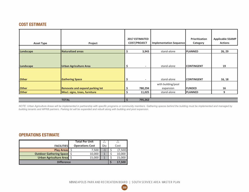
Asset Type Project 2017 ESTIMATED
COST/PROJECT Implementation Sequence Prioritization
Category Applicable SSAMP
Actions
Landscape Naturalized areas 3,943$ stand-alone PLANNED 26, 29
Landscape Urban Agriculture Area -$ stand-alone CONTINGENT 19
Other Gathering Space -$ stand-alone CONTINGENT 16, 18
Other Renovate and expand parking lot 780,294$ with building/pool
expansion FUNDED 16Other Miscl. signs, trees, furniture 11,025$ stand-alone PLANNED 9
TOTAL 795,262$
building tenants and MPRB partners. Parking lot will be expanded and rebuilt along with building and pool expansion.
OPERATIONS ESTIMATE

201
MINNEAPOLIS PARK AND RECREATION BOARD | SOUTH SERVICE AREA MASTER PLAN
CH 4
| N
EIGH
BORH
OOD
PARK
PLA
NS |
POW
DERH
ORN
LOCATION AND HISTORY
places considered for a park in Minneapolis. Only two months after the park board was created by the state legislature and approved by Minneapolis voters in April 1883, residents in the vicinity of the lake petitioned the park board to make it a park. But instead of a park at Powderhorn Lake, the board’s focus across south Minneapolis was on a parkway proposed by landscape architect Horace Cleveland that would have extended from the Mississippi River to Lake Calhoun along 34th Street. That plan would have incorporated Powderhorn Lake into a parkway that met up precisely with Summit
POWDERHORNAvenue on the St. Paul side of the river. The parkway project across south Minneapolis was abandoned in 1885 because the land was too expensive.
During that time the park board did consider a park at Powderhorn Lake and between 1884 and 1887 was
donation. In 1890 the park board acquired 38 acres around the lake through condemnation. Almost as soon
petitioned the park board to add 25 acres to the park on the west and south. Powderhorn Park was expanded in 1891 by nearly 20 acres, with only several individual lots still to be acquired to complete the park. Also in 1891, the park board established a skating rink on the
1892 Horace Cleveland and his son Ralph submitted their plan for Powderhorn Park. The name was taken from the name of the lake, which was named for its shape: an old powderhorn—a cow horn used to carry
of the Fort Snelling Military Reservation.
The most striking feature of the Cleveland plan is that the lake at that time extended north to 32nd Street. The northern arm of the lake no longer exists; nearly
years of low water levels in the lake. Cleveland’s plan for the park included the creation of an island near the southern shore and a bridge over the narrow neck of the lake at 33rd Street. In 1895 dredging deepened
including the creation of the one-half acre island.
The western section of the park was initially graded
was established at Powderhorn Park in 1907 along 10th Avenue between 32nd and 33rd Streets. A toilet building was installed as well. In the 1907 annual report new superintendent Theodore Wirth provided a detailed
plan for the development of Powderhorn Park, which included a feature Cleveland had recommended years before, a bridge over the narrow neck of the lake at about 33rd Street. Wirth’s plan also included a much wider lake north of the bridge.
Wirth also recommended a recreation building at the southeast corner of the lake, complete with a boat landing in front of it. A shelter in that location was completed in 1908, and basketball hoops were also
10th Avenue playground was moved to the southeast corner of the park, because of noise complaints from
also built that year near 10th Avenue and 34th Street.
Beginning in 1911, Wirth began to advocate for reducing
the northern arm was begun in 1924 and completed in 1925. During the reshaping of the park eleven new tennis courts were added as well.
The smaller lake became home to an important attraction in winter, a speed skating track that hosted national skating championships and Olympic speed-skating trials in the 1930s. The Olympic trials were held again at the track in 1947 and four of the nine skaters to win spots on the U.S. Olympic team were from Powderhorn Park. The speed skating track was moved to Lake Harriet in the early 1960s and later shifted to Lake Nokomis. The speed skating track was reopened at Powderhorn in 1990, but was shifted to Armatage Park in 1999 as an experiment. It has since been discontinued.
In 1963 the recreation building was renovated

202
MINNEAPOLIS PARK AND RECREATION BOARD | SOUTH SERVICE AREA MASTER PLAN
Existing Conditions: Powderhorn

203
MINNEAPOLIS PARK AND RECREATION BOARD | SOUTH SERVICE AREA MASTER PLAN
CH 4
| N
EIGH
BORH
OOD
PARK
PLA
NS |
POW
DERH
ORN
E 35
TH S
T
14TH AVE S
10TH AVE S
15TH AVE S
AP
0’ 40’ 80’ 160’
Preferred Plan: Powderhorn
Enlargement

204
MINNEAPOLIS PARK AND RECREATION BOARD | SOUTH SERVICE AREA MASTER PLAN
Existing Conditions: Powderhorn Enlargement

205
MINNEAPOLIS PARK AND RECREATION BOARD | SOUTH SERVICE AREA MASTER PLAN
CH 4
| N
EIGH
BORH
OOD
PARK
PLA
NS |
POW
DERH
ORN
POWDERHORN ENGLARGEMENT
15TH AVE S
0’ 20’ 40’ 60’
Preferred Plan: Powderhorn Enlargement

206
MINNEAPOLIS PARK AND RECREATION BOARD | SOUTH SERVICE AREA MASTER PLAN
UPDATE EXISTING
Traditional Play Structure
Wading Pool
Stage / Bandshell
Designated Sledding Hill
Multi-use Field
Multi-use Diamond
Tennis Court
Basketball Court
Urban Agriculture Area
Equavolley Court
Restroom/Storage Building
Walking Loop Trail
Adult Fitness
Skating Rink
Nature play area
Adventure Play
Group Shelter
Premier Field
Multi-use Field
Urban Agriculture Area
Community Oven
Outdoor Gathering Space
Basketball Court
Canoe/Kayak Launch
AP
NEW/ ADDEDconditioning. That year the hockey rink was moved from the lake, but general skating was retained. A new totlot for smaller children was installed in the park at 14th Avenue and 35th Street in 1968. The totlot was a prototype for nine others installed around the city later that year. The old twice-renovated shelter beside the lake was replaced with a modern recreation center with a gym in 1971-72. That facility was remodeled in 1996-97. At that time a pump system was installed in another attempt to control the level of water in the lake. A new
innovation at Powderhorn Park was introduced in 1995 when “Powderhorn Prairie” was created by seeding the east and north hillsides of the park with native grasses. Construction of a new concrete path and lighting around Powderhorn Lake was completed in 2013.
EXISTING CONDITIONS AND CHARACTERPowderhorn is the largest neighborhood park in the south service area and is the green heart of a unique neighborhood known for its artistic festivals, racial and socio-economic diversity, and creative spirit. Powderhorn Lake with its wooded island is surrounded by forested, hilly green space that seems far less developed than other neighborhood parks in the area. The park is laced with walking trails and peppered with a variety of active uses that nestle into the slopes and trees.
The recreation center area touches the southeastern edge of the lake. The building itself is always active. A wading pool, playground, basketball court, and parking lot are adjacent to the building. Three other playgrounds exist in the park, at the southeastern
adjacent to 14th Avenue. Sports activities also have a home in the park. The so-called “bowl” north of the lake (in the area of the former northern arm of the lake) is home to three ball diamonds and a large area of multi-
of the park are also often used for pick-up sports. Five tennis courts sit in the southwestern corner of the park.

207
MINNEAPOLIS PARK AND RECREATION BOARD | SOUTH SERVICE AREA MASTER PLAN
CH 4
| N
EIGH
BORH
OOD
PARK
PLA
NS |
POW
DERH
ORN
Overall, Powderhorn feels idyllic. People stroll the paths, lounge under the trees, and contemplate the lake. Pockets of high activity—near the recreation
overwhelm the quietude. The park, however, ramps up to excitement during the many festivals held there year-round. From art sleds to skating to basketball to pottery
and rich as the neighborhood that surrounds it.
CONNECTIONS BETWEEN PARKS
should focus on:
• The proposed Southside Greenway, a community and City of Minneapolis led project that will run on 10th Avenue immediately adjacent to the park. Exactly how the greenway interfaces with Powderhorn Park has yet to be determined, but the SSAMP supports continued discussions.
• The existing City of Minneapolis pedestrian and/or bicycle connection along 34th Street, which connects east to Corcoran Park and west to Central Gym.
THE PROPOSED DESIGNThe design for Powderhorn seeks to preserve the existing well-loved character of the park while making several key enhancements to the visitor experience. The trail network is mostly unchanged, and the forested
enhanced. Two new picnic shelters—one by the sports area along 14th Avenue and the other near the
gathering. One features a community oven. Many facilities, such as the tennis courts, restroom building, stage, storage building, parking lot, and wading pool are retained in place but improved. The main changes proposed by the plan fall into three main categories: play, athletics, and the waterfront.
In the interest of diversifying play in the park and the service area as a whole, new nature and adventure play areas combine with some retained traditional play areas
the recreation building and along 10th Avenue remain traditional, with play equipment in containers. On the slope facing away from 14th Avenue an adventure play
features—expands the appeal to more age groups and physically challenges older kids and teens. In this same area, a small totlot provides an opportunity for younger children. In the southeastern corner of the park is a combined urban agriculture and nature play
to participate in healthy, mentally and socially rich, cooperative, and calming play and work. These two activities go well together because both need similar infrastructure—water and sun exposure—and both foster the same spirit of getting back to the land.
In terms of athletics, the northern portion of the park is changed to address the recreational desires of the community. In the “bowl,” one multi-use diamond is
northwestern corner of the park, along 10th Avenue, a
ad-hoc grass area there now. Along 14th Avenue, the
be improved but retained as natural grass multi-use
level of use for this sport, while also addressing both neighbors’ concerns about dust and dirt and players’ desire for a hard surface. The volleyball courts are set
Near the recreation building, the plan takes better advantage of the lovely but currently under-appreciated vista across the lake. A new gathering space by the water is designed to allow interaction with the lake at any water level, while a larger “dock” reaches out over
of this design is to modify the rear of the recreation center building to open onto the waterfront. Glassy
building extensions glow like lanterns in the summer night and winter evening, serving as warming house, rainy-day reading nook, or event space. A café could
goers. The community would very much prefer this be a local business with some history of contributing back to the community. The Powderhorn waterfront will become a destination for the neighborhood and the city—a meeting place for makers and creative souls, a resting place after a walk around the lake and through the woods, a multi-cultural place where many languages
and enhances the beauty of the park.
KNOWN LAND USE AND COORDINATION ITEMSNo known land use issues exist with Powderhorn Park.

208
MINNEAPOLIS PARK AND RECREATION BOARD | SOUTH SERVICE AREA MASTER PLAN
PROCESSESaq
uatic
s Wading pool is considered in poor condition, leading to safety issues. Desire for bigger, deeper pool
no comments Wading pool in same general location
Play areas need improvementSupport for retaining play area on southeast corner
play Support for nature play
More need for soccer than for baseball
Significant concern about fenced premier fields in the bowl at northern end of park; preference for open multi-use fields
Removal of one multi-use diamond to create larger multi-use field space in the "bowl" at the northern end of the lake.
Open areas on northwest corner of park and eastern edge of park used for pick-up sports
Addition of multi-use field areas for unprogrammed play at the northeast corner of the park
Real desire for premier fields in the park
Addition of premier field at northwest corner of park
cour
ts
Tennis courts well likedBasketball better near the building; two courts necessary
Five tennis courts in same general location
Basketball court heavily used and could use improvement
Concern about dust and dirt from volleyball play
Two full basketball courts near the building in the southeastern portion of the park
Desire for hard-court volleyballAddition of three hard-court volleyball courts near 14th Avenue, buffered from street
athl
etic
s
Retain four play areas in the park: two traditional play areas near the recreation center and on the western edge of the park; one adventure play area with traditional equipment for smaller children in the northeast portion of the park; one nature play area combined with urban agriculture area at the southeast corner of the park

209
MINNEAPOLIS PARK AND RECREATION BOARD | SOUTH SERVICE AREA MASTER PLAN
PROCESSES
CH 4
| N
EIGH
BORH
OOD
PARK
PLA
NS |
POW
DERH
ORN
PROCESSES CONT.
no comments no comments Skating on lake, as existing
Expansion of building toward lake to include winter warming house and possible cafe/restaurant
Urban agriculture areas desired no commentsUrban agriculture area designated at southeast corner of park (in concert with nature play area), and along southern slope
More native plantings that are well maintained, not just weedy patches
Addition of naturalized plantings throughout park, primarily on slopes
Improve water quality in lake; add rain gardens and other storm water management
Like fishing pier/dock; consider canoe/kayak storage and boat rental
Consider group shelter with community oven near the building
Revision of southern dock to create a higher-quality seating, gathering, and fishing area; addition of smaller dock at northern end of lake
Support for vita course around lakeGeneral support for building expansion with concession and warming house
Addition of group shelter with community oven near the recreation center; addition of a group shelter near the adventure play area and multi-use fields along the eastern edge of the park
Stage area could be improved into a full amphitheater setting
Mixed opinions on the new dock on the north end of the lake
Addition of canoe/kayak storage near recreation center building
Add concessions / restaurant Enhancement of vita course
Enhancement of stage in same general location
othe
rla
ndsc
ape
win
ter

210
MINNEAPOLIS PARK AND RECREATION BOARD | SOUTH SERVICE AREA MASTER PLAN
COST ESTIMATE
Asset Type Project 2017 ESTIMATED
COST/PROJECT Implementation Sequence Prioritization
Category Applicable SSAMP
Actions
AquaticsWading Pool,
739,226$ FUNDED 16
PlayEast: Traditional Play Structure in existing container 216,000$ FUNDED 16, 23b, 23d
PlayWest: Traditional Play Structures in existing container 216,000$ FUNDED 16, 23b, 23d
PlayNorth: Small Traditional Play Structure in new container 108,000$ FUNDED 16, 23b, 23d
Play North: Adventure Play Area 1,396,316$ PLANNED 16, 23a, 23b, 23d
Play Southeast: Nature Play in new container 698,158$ PLANNED 16, 23a, 23b, 23d
AthleticsAthletic Field renovation, bowl:
2,488,728$ PLANNED 16, 21a, 21b, 21d
Athletics Premier Athletic Field, 10th Avenue side 1,149,908$ PLANNED 16, 21c, 21f
AthleticsAthletic Field renovation, 19th Avenue side:
312,118$ PLANNED 16, 21b, 21dCourts Tennis Court (5) 533,886$ PLANNED 16 Courts Basketball Court (2) 213,554$ PLANNED 16, 22aCourts Volleyball Court (3) 320,331$ PLANNED 16
Landscape Naturalized areas 328,545$ PLANNED 25, 26, 29Landscape Existing parking lot renovation 276,601$ PLANNED 28 Landscape Urban Agriculture Area 25,018$ DEPENDENT 19
Other Adult Fitness: 41,068$ PLANNED 16, 18Other Building expansion 1,355,248$ PLANNED
OtherGroup picnic shelters:
90,350$ PLANNED 18
OtherGathering area near recreation building:
137,989$ PLANNED 18

211
MINNEAPOLIS PARK AND RECREATION BOARD | SOUTH SERVICE AREA MASTER PLAN
CH 4
| N
EIGH
BORH
OOD
PARK
PLA
NS |
POW
DERH
ORN
OPERATIONS ESTIMATE
COST ESTIMATE (CONT.)
OtherGathering area near recreation building:
137,989$ PLANNED 18
OtherRenovate Existing Buildings:
225,875$ PLANNED 18 Other Renovate walking paths 1,051,344$ PLANNED 10, 16, 17
Other Waterfront Area by recreation building 144,560$ PLANNED 18 Other Dock at northern end 39,425$ PLANNEDOther Miscl. signs, trees, furniture 157,246$ PLANNED 9, 10, 17
TOTAL 12,265,494$
Asset Type Project 2017 ESTIMATED
COST/PROJECT Implementation Sequence Prioritization
Category Applicable SSAMP
Actions

This page was intentionally left blank

213
MINNEAPOLIS PARK AND RECREATION BOARD | SOUTH SERVICE AREA MASTER PLAN
CH 4
| N
EIGH
BORH
OOD
PARK
PLA
NS |
ROL
LINS
TRIA
NGLE
ABOUTRollins Triangle is considered a “special case” in the SSAMP planning process. Located along Minnehaha Avenue at 33rd Street, it is one of three MPRB-owned triangles (with Adams and Normanna) amongst the many that occur where the angle of Minnehaha Avenue intersects with the regular street grid of south Minneapolis.
Rollins Triangle was taken over by MPRB at the request of the Minneapolis city council in 1929. It has a total area of 27 square feet, making it likely the tiniest park in the system. MPRB ownership is actually much smaller than it would appear. The triangle is bounded on three sides by streets, but when rights-of-way are removed, only that tiny triangle remains.
ROLLINS TRIANGLEWhen Minnehaha Avenue was redesigned in 2015 and 2016, many angled streets were reworked to enter Minnehaha at right angles. Though no street would cut through Rollins, an associated sidewalk was planned to entirely cover the park parcel. In 2015 MPRB approved a permanent easement to the County to use Rollins as part of the sidewalk network. Due to its extremely small
has been prepared for Rollins Triangle as part of the SSAMP.

This page was intentionally left blank