3h4 - apps.dtic.mil
TRANSCRIPT

<5> 3h4
••\-D
OFFICE OF EAVAL RESEARCH
o z: — ^_ rTT Edward L. Ullman, Director CD GO
Contract No. Nanr-V77(03)
TRANSPORTATION GEOGRAPHY
by Edward L. Ullman
with the collaboration of Harold M. Mayer
March 1954
Report No. 9
University of Washington
Seattle, Washington

T«3$ *f*G*? MAS SEEN DELIMITED
**£ CUAftED h* PUSUC PEUASE
UNDf* DCD DlftECTIVE 5200,20 AND
NO *£STRICTJONS ARE IMPOSED UPON
ITS usf A«D DtSCtOSOKE.
DISTRIBUTION STATEflNT A
APPSOVEC EO* PUBUC RELEASE;
D:S?PI8UTI0N UNLIMITED.

r 1
TRANSPORTATION GEOGRAPHY*
by Edward L. Ullman, with the collaboration of Harold M. Mayer
NATURE OF TRANSPORTATION GEOGRAPHY p. 1
RESEARCH IN TRANSPORTATION GEOGRAPHY p. 2
European Studies ..... p. 3 Studies in the United States p. 4
OBJECTIVES Of TRANSPORTATION GEOGRAPHY p. 6
Measurement and Mapping .p. 6 Transportation Rates . . . . . p. 10 Relation of Routes to Environmental Conditions ..... p, 12 Effects of the Changing Technology of Transportation « , p. 12 Geographic Theory and "Social Physics" p. 13 Applied Transportation Geography ....... p. 15
REFERENCES p. 17
*Reproduced from American C?o?raphy: Inventory and Prospect (P. E. James and C. F. Jones, editors, published by Association of American Geographers, Syracuse University Press, 1954), chapter 13, pp. 310-332.

r I Transportation is a measure of the relations between
areas and is therefore an essential aspect of geography. The economic relations and connections between areas are reflected in the character of transportation facilities and in the flow of traffic. Transportation is a major part of the "geography of circulation," as the latter term is used by the French geographers. In fact, this term, although not widely used in English, seems to be the most desirable and all-inclusive label for the subject. Geography is concerned with all spatial connections and interactions, including communication and transportation. The study of trans- portation or circulation thus cuts across all fields of human geography. It sheds light on such diverse problems as the dif- fusion of cultural traits or the resistance offered by political boundaries. The field of transportation geography in the United States is undergoing a new development, although it is still in the stage©f seeking the most effective procedures for making measurements, for carrying out geographic analyses, and for arriving at useful concepts of wide application.
A number of geographers, both in Europe and America, are coming to recognize that the study of the connections between areas and of spatial interchange can provide a new and deeper insight into the meaning of areal differentiation. They see transportation as providing a key for measuring the significance of likenesses and differences among places on the earth. For those geographers who view the core of geography as primarily the analysis of spatial interaction, the study of transportation and, in the broader sense, of circulation as a whole is of crucial Importance |_1 .! . P. R. Crowe insists that geographers are more concerned with currents of men and things moving than with static transport forms, as such [2'J • Transportation facilities are examined primarily as indicators of the degree of connection and as patterns of spatial interchange.
NATURE OF TRANSPORTATION GEOGRAPHY
Students of transportation geography have been primarily concerned with its economic aspects. Transportation stands as one of the four traditional components of economic geography: primary production, manufacturing, marketing, and transportation. The ease or difficulty of moving things over the earth, the volume of traffic, and the distances involved have profound effects on the nature and arrangement of economic activities of all kinds.
Changes in the technology of transportation during the past two centuries have resulted in a great reduction of the cost per unit of moving goods from one place to another. This, in turn, has made possible the economic specialization of areas, the substitution of interdependence for self-sufficiency, and has produced the notable areal differentiation in forms of production and land use that characterizes the modern world. Transportation overland used to be slow and costly. Bulk movements of raw materials at all comparable to the shipments which come daily to a modern steel plant were unknown. Each area of concentrated settlement, therefore, had t? produce most of its own fuel, food,
L

r i -2-
and other necessities, and trade was restricted largely to luxury items that could stand the high cost of shipment. To be sure, the relative cheapness of transportation by water permitted a certain amount of crop specialization even in sailing-ship days: as witness the dependence of Athens on the wheat lands of what is now the Ukraine, and the dependence of Rome on grain shipped by sea from Egypt and other parts of North Africa. The partial dependence of Great Eritain or specialized producing areas over- seas began before the development of modern forms of transporta- tion. But the railroad for the first time in history provided cheap bulk transportation overland and set the stage for the appearance of specialized agricultural regions in areas remote from navigable water. For the first time on a worId-wide scale it became possible to take advantage of locally favorable condi- tions of land, labor, and capital for the specialized low-cost production of goods destined for distant markets. Improvement of transportation thus radically altered the scale of geography by substituting larger and more distant regions of production for smaller ones nearby. This contrasts with von Thunen's famous model of concentric producing regions around a city in the Isolierte Staat of 1827.
Transportation consumes an important part of the world's energy. In a modern industrial country like the United States, an estimated 20 percent of the labor force is directly or in- directly employed in the operation, servicing, manufacturing, and selling of transportation and communication. In a primitive society, equipped with little or no machinery, the daily output of energy is great, as each person laboriously moves things from place to place within a small area; but the volume and distanco of movement are small; the scale and range of spatial relations are likewise small. Among peoples of similar cultural status, the amount of energy given to circulation varies from place to place with the natural endowment and with differences in economy. Iowa, for example, ships a smaller tonnage of agricultural products than that shipped by either of its neighbors, Nebraska or Kansas, mainly because Iowa farmers feed their corn to cattle and hogs on the farm. The result Is a product of lighter weight but greater value, and a consequently smaller demand for transportation. In certain places, transportation is the major industrial employer: for example, in a railroad town such as Altoona, Pennsylvania. In a country like Norway, which provides shipping service for the whole world, tha proportion of the total population employed in transportation is also quite high.
The actual physical facilities for transportation may be examined and napped for geographical, as well as engineering, purposes. In many cases, where data on the flow of traffic, are inadequate, the facilities provide the best indicator of the volume and. route of movement. The transportation geographer needs some familiarity with the technical or engineering aspects of such facilities if ho is to determine the significance of, for
L

e
r -i -3-
example, the type and depth of railroad ballast, the weight of rails, or the types of railroad signals, or if he is to evaluat the capacity of railroad yards or of a port. Similarly the interpretation of the significance of a net of highways requires technical knowledge both of highway engineering and also of the geographic method.
The study of ratesaad costs is an aspect of transporta- tion geography that touches on the field of economics. Just as the effective study of transportation facilities calls for some familiarity with engineering, so also the study of rates and costs calls for some understanding of the findings of economic and busi- ness research. The specialist in transportation geography, equipped with an adequate background in these related fields, is in a position to make a unique contribution to the interpretation of the factors in, and the nature.of, spatial interchange,
RESEARCH IN TRANSPORTATION GEOGRAPHY
In view of the obvious importance of transportation to geography, it is surprising how little professional work concern- ing it has been done by geographers. Transportation studies in the United States have been made mostly by scholars in other professional fields, and from non-geographic viewpoints. Geogra- phers should not count on using these studies secondhand to arrive at significant geographical objectives. Although specialists in transportation geography are few, the importance of their contribution has already been recognized by economists and others.
Specialists in this field must attack their problems with quite inadequate statistical data especially in the United States and Britain. Such data as are available are usually too general to lend themselves easily to the kind of analysis re- quired for geographic purposes. This situation results in part from; 1) war-time restrictions on the publication of this kind of information, 2) the competitive relations between private carriers, and, finally, 3) from a general lack of interest in localized or geographic data in collection agencies in the past, although this rruy well be remedied in part in the future, as will be shown later.
In the two sections which follow some of the previous studies in the transportation field in Europe and America are noted, but without any attempt at systematic coverage. Certain of the more important recent works are listed in connection with the discussion of the objectives of transportation geography.
European Studies The Europeans have done more in the field of transporta-
tion geography than have their colleagues in the United States» This may be a result, in part, of the fact that statistical data of the kind geographers need are more readily available. German
t

r i -4-
v/riters have produced several works on Verkehrsgecgraphle, many of which are now out of date and have been criticized as being merely encyclopedic and of little penetrating value. Notable original studies on land transportation, however, have been made by Erwin Scheu, Helmut Haufe, and others *.3; 4]. In France, a detailed and lengthy work by H. Lartilleux describes the French railroads, not only bhose of continental France but also :>f the outlying parts of the country and of its colonies (_5"!« This four-volume work contains a vast amount of information on track layout, signal equipment, grades, and other physical characteris- tics. Information of this sort that can be specifically located on a map 13 not usually available for publication in the United States. It was originally intended to extend this compendium of information regarding the French railroads to other forma of transportation and to other parts of the world. The difficulties of obtaining the necessary data, however, make the completion of the work doubtful. The stimulating study by Robert Capot-Rey, published in 1946, is less encyclopedic but is restricted to certain aspects of land transportation as related to settlement and environment and does not attempt to covor economic and traffic features i.6.|. There are also several excellent French studies of local transportation facilities and of the flow of traffic, such as Rene Clozier's La tore du Nord p7]. and works on other aspects of rail transport by Maurice Parde. In England important trans- portation studies have been made by S. H. Beaver, K. C. Edwards, A. C. O'Dell, and others. Notable also are the works of 0. G. Jonas son in Sweden and Aage Aagesen in Denmark [8. .
More attention has been devoted to ocean trade and to ports in European studies than has been given to other aspects of transportation. A. J. Sargent's earlier books on seaways and ports, as well as work by L, flecking on Japan, particularly come to mind j'9; lOj. In 1952, F. W._ Morgan published a brief, general treatment of ports and harbors ill', and 0, Holcko completed a monumental study on the port of Stockholm's freight traffic [12!. W« E. Boerman in the Netherlands has contributed marine studies some of which are noted, along with studies by other European geographers, in the report of the Commission on Industrial Ports of the International Geographical Union 13i. Tno Norwegian geo- graphers, Tore Ouren and Axel Sjrfmmo, published an important '[141 analysis of trends in trade and shipping between the two world wars, and Andre' Siegfried pictured the results of the opening of the Suez and Fanam- Canals on the patterns of world transporta- tion fl5j.
Studies in the United Stater, The changes in the" patterns of world trade that followed
the opening of the Panama Canal stimulated some of the earliest works in the field of transportation geography in the United States* A pioneer work in this field was the book on ocean commerce by J. Russell Smith, published in 1905 [16*;. Although a number of
1 -J

")
-5-
general texts on ocean trade and transportation have appeared, geographers in the United States had not probed deeply into this subject until they did so fof the various government agencies daring World Wars I and II.
On the other hand, there are a number of studies of individual pc-ts by American geographers. Tne relatively greater attention paid to ports is in part a recognition that such places are significant focal points in the pattern of world trade, and are sufficiently compact to permit field investigation; but it is also in part a result of the greater availability of statistical data useful for geographic purposes concerning the movement of goods in and out of ports. Of the many papers published on ports in the United States, four may be cited as representative ,il7; l8j 19; 20j« A few geographers have participated officially as directors and staff members of organizations that produced plans for port development 21 , Geographical studies of ports are usually concerned either with the movement of goods be- tween a hinterland and the other parts of the world reached by water routes, or with the port facilities as an aspect of urban land use, During World War II, new tecliniques of port description, new kinds of maps, and new ways of estimating port capacities were worked out, and applied to ports around the world that had never previously been examined in such detail. Unfortunately, most of these war-time research monographs are unavailable.
A considerable number of geographers have also worked on various asnects of railroad patterns and facilities. Mark Jefferson produced a striking portrayal of the railroad patterns of the several continents 22 , in which he identified various degrees of railroad density by such terms as railweb, railnet, rail tentacle, or riverlink, Edward L. Ullman classified railroads of the United States according to their importance based on the number of tracks and the system of signalling '23 • Of direct practical importance are the studies of railroad terminals in relation both to the ease of movement of goods in and out of cities and to the functional patterns of cities. Harold Mayer's study of the railroad pattern of metropolitan Chicago '2k and of the passenger terminal problem of central Chicago j25 are among the geographical contributions to problems of this sort, Geogra~ phers, whose point of view leads them to see the areal associations of economic activities, land uses, and transportation facilities, are beginning to apply their methods to the practical problems of planning urban and metro- politan development and of providing for the effective service of metropolitan areas by transportation systems,
A few studies by geographers in the United States also deal with various aspects of air transportation. Professional geographers have been employed by the airlines and by regulatory agencies in the planning of new routes and in estimating the traffic potential of areas not previously sex'ved. The establishment of long-distance, and especially trans-oceanic, airlines has modified the accessibility pattern of major portions of the earth, and these changes have stimulated some studies comparable to those that appeared many decades earlier regarding the patterns of ocean trans- portation ,26; 27 . Airports have been examined in terms cf the patterns of connection with other areas and also as a land-uce category in the city '28; 29j 30;'. ?he effect of airports on other urban uses of land has received little attention.

r 1
L
-6-
In the literature of American geography there are almost no studies of the interrelations among the various forms of transportation, or of the effects of transportation on other aspects of human geography. Two exceptions, both relating to the problem of supporting cities, are a study of Salt lake City by Chauncy D« Harris and one of Mobile by Edward L» Ullman "31j 20!•
OBJECTIVES OP TRANSPORTATION GEOGRAPHY
Studies in various aspects of transportation geography are undertaken for a number of different objectives. In order to establish the connections between areas and the nature of the spatial interchange, it is necessary to find some way of measuring and mapping the flow of traffic, including its volume and .speed of movement and its origin and destination. Closely related to the study of traffic flow are geographical analyses of rates and rate structures, studies of the effect of terrain and other environmental conditions oh transportation, and con- versely studies of the effect of the changing technology of transportation on the significance of environmental circumstances and on the process of economic development of areas on the earth. Transportation studies also are related closely to the concepts of geography as a whole, and such studies contribute to the formu- lation and evaluation of geographic theory. Transportation studies al3o are practical and can be applied to specific current problems.
Measurement and Mapping Transportation geography, due to the lack of proper
data, is still in the stage of searching for better methods of measurement and mapping. Many old conclusions and concepts are unreliable because they are based on insufficient quantita- tive data, such as the erroneous idea that the New York Central, rather than the Pennsylvania, has the heaviest traffic between east and west. In the absence of direct data, such as traffic flew on railroads, other indicators can be used to construct meaningful maps. For example Ullman's map of the railroads cf the United States classifies lines according to number of tracks and type of signalling, the best quantitative indicators of flew and of relative importance available from records j32; 25 \,
Statistics that give the volume of traffic moved along a specific route and that make possible the mapping of the origin and destination of flows are particularly difficult to obtain in the United States, To be sure, some commercial re- search organizations, such as H. H. Copeland and Son, produce traffic-flow maps of individual railroad systems, but the great expense of such maps and the fact that they are confidential has precluded thoir regular use in geographic studies, except those undertaken for specific railroad companies. It is worth noting, however, that Copeland and Son recently granted permis- sion for the reproduction of a small-scale version of a traffic-
-J

r i -7-
flow map of the United States in a forthcoming publication by Ullnan. Some individual railroads have prepared their own traffic-flow maps; information of this sort for two Canadian railroads has been published in fugitive government reports. The voluminous statistics published in the United States by the Interstate Commerce Commission, however, are not broken down into sufficient detail to be useful for many geographic purposes.
On the other hand, statistics of geographical value do appear from time to time. The Interstate Commerce Commission in 1947 started the issue in mimeographed form of an annual one-percent sample of rail waybills that makes it possible to chart rail commodity movements by States of origin and destination. Ullnan has mapped and briefly interpreted some of these data in two papers soon to be published. A sample of the maps is offered in Figures 1 and 2 , showing the shipments of animals and products to and from the State of Iowa, with the width of the lines pro- portional to the volume of traffic. Briefly, these two repre- sentative maps show for the first time graphically and quantita- tively: 1) the generally greater volume of shipments to nearby points than to more distant points, a reflection of the friction of distance; 2) the greater volume of outbound over inbound traffic, reflecting Iowa's roie as the leading animal producer, chiefly hog3 and hog products, in the United State?; 3) the heavy move- ment to the markets of the industrial northeast, which is suf- ficient to counteract the friction of distance (note especially the shipments to the deficit meat areas of New York and Hew England); 4) the small but distinctive flow to the rising California market, a new feature of American economic geography; and 5) the general west-to-sast movement in the United States, a fundamental feature of American economic geography, reflecting heavy raw materials moving to eastern industrial areas, generally outweighing the backflow of lighter-weight industrial products.
For studies of port traffic, useful data are frequently available. Yet the 3tudent is often presented with data that are not exactly what are needed. For example, statistics on the value of shipments or the tonnage of vessels calling at a port are less significant for many purposes than figures of actual weight loaded and unloaded. In other cases only foreign exports and imports are shown, as though a shipment from New i'ork to Cuba were of greater geographic significance than one from Hew York to California by water. Admittedly, no one total measure is perfect. For example, combining tons of liquid bulk (principally petroleum), dry bulk (coal, wheat, ore, etc) and general cargo, combines unlike items. Liquid bulk can be pumped and requires little in the way of port facilities; dry bulk is generally handled by machinery in large quantities, and a given tonnage of dry bulk is usually of less significance to a port than the same tonnage of general cargo.
L

1
1948 \ x> ORIGIN OF
IOWA ANIMALS AND PRODUCTS ^M. J 50.000 TONS
Fig. 1. Origin, by states, of animals and products shipped into Iowa by r«il, 19^8. Width cf lines is proportionate to volume (of short tons of 2,000 lbs.) on Figures 1 and 2.
1948 >
DESTINATION OF
IOWA ANIMALS AND PRODUCTS «•-» =• 50.000 TONS •••••W.. 3 IO.OOO TONS
1-M.lihO L UL1_M«N
Fig. 2. Destination, by states, of animals and products shipped out of Iowa by rail, 19*+8. Source of data for Figures 1 and 2 is Interstate Commerce Commission's 1 per cent sample of rail traffic reported in Carload Waybill Analyses, 19^, Washington, D.C. (statements: U838, October, 19^8; V92, January, 19^9; ^98, March, 19^9; U92O, June, 19^9).
L

r i
- - : 4 - 9000 TONS TMCf SOLID LINES PK-.POHT-.ONA-L rO T0MNACC3
fcRROWb SHOW D'BCCT.ON OF FLOW
FIGURES IN lOOCS Of SHOP- 10'i-j
SAMF TONMAGE SC*l E ON bOTH MAPS
Fig. 3. Ocean Trade of Mobile, 1936. The map is also essentially- correct for 1937 and 1938.
S
-J

r i
L
1 <U
•P
O
QJ -d Pj *H -P
(3 a) 0) u o
ft •H o (3
•H IH Pi
-d a M
to o3 0.'
-p en n) o o
>> 43
CO m ON
-P
•H 0)
o
3
-a CD m
•p a!
•P ra -d
CD -p
bO •H
L _j

1
<^)&>N i
a a) <u CJ O
a) ft
•rH
U
d •H fn ft
c. a CO id
id
a)
en
O U
£1
CO ;n ON
0)
cd
•p
a 5) •H QJ fn O
CD
et)
.Q
3 a1
CO
CU
cd •p CO
-p •H
5
VD 0)
• T3 bO n5
•H C PM -P
1 u

r
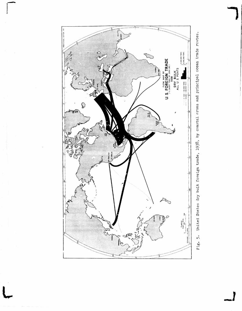
More difficult to obtain are data on the routes of movement. Examples of new mapping are oresented in Figures 4, 5, and 6 which show in preliminary form the foreign trade of tne United States by coastal areas for dry bulk, liquid bulk, and total tonnage for 1938; and in Figure 3 , which shows the com- plete flow to and from Mobile, Alabama, for both foreign and domestic trade. Such maps provide at a glance a muuh clearer characterization of the actual oceanic connections than could be gained from pages of words or statistical tables. As yet direct data are too fragmentary to permit the preparation of similar naps for world traffic flow. However, other kinds of information could be used to provide something more or less equivalent. The British Chamber of Shipoing, for example, in 1935 and 1937 published maps showing the position of all British ships at sea at a given time. Trade routes, and the volume of movement along them, stand out fairly well on these maps L.33J. Some adaptation cf this method might be used to provide world maps of the flow cf ocean traffic.
At the time of writing, the Maritime Administration, the Corps of Engineers, and the Bureau of the Census are planning to publish tonnage statistics ty routes on a coastal-area to coastal-area, or a port-to-port, basis, arranged by major commodities for all the ocean trade of the United States. Geo- graphical analyses of the pattern and meaning of such trade will then be enormously facilitated. Unfortunately, the disclosure rule will prevent some of these data from being made public, as, for example, on the Seattle-to-Alaska route where one steamship line is dominant. Already the Corns of Engineers, and to some extent the Maritime Administration, publish figures by commodities of all ocean trade from ports of the United States, but the routes, origins, and destinations of these flows are not shown. Facilities available in ports of the United States are described^ in detail, but not interpreted geographically, in the PORT SxiEIES, published jointly every few years by the Corps of Engineers and the Maritime Administration.
Inadequacy of data also makes the mapping of traffic flow on inland waterways difficult. However, it is possible to make rather general flow maps from figures available in manu- script from the Corps of Engineers, as Donald Patton has done for the United States as a whole. Great Lakes flow map3 for major commodities are contained in reports of the Corps of Engineers, and at least two geographers have mapped and analyzed aspects of the grain trade [34; 35j. Recent inland-waterway studies include, among other things, an analysis of the commerce of the Ohio River and the Illinois Waterway 136j.
In spite of the availability of statistics on highway traffic in the United States, geographical studies of highways are few. Yet some 85 percent of the total volume of intercity passenger traffic moves by highway. There are masses of statis- tics on highway traffic flow, and, within the last few years,
t
r i •O-.
data have been gathered on origins and destinations for most metro- politan areas. Nearly every State and county and most municipal highway authorities produce tabulations and macs of highway and street traffic flow. Since World War II, under the leadership nf the United States Bureau of Public Roads, scores of cities and metropolitan areas have conducted origin-destination surveys, which include all trips made to, from, and within the respective survey areas, classified by origin and destination in tarns of zones of varying size, with maps and tabulations by time of day, purpose of trip, elapsed time, type of conveyance, and, in some instances, by age, sex, and occupation of the person involved. Surveys of this sort should prove very useful for geographers in the study of the functional and dynamic organization within urban areas, although inadequate for analyses of larger areas (chapter six). Most such surveys are carried on primarily for highway-planning purposes; consequently, the tabular and carto- graphic forms in which the data are presented are not always those of maximum utility for geographic research. Geographers can do much to secure the kind of information they would find most usefu] by participating in the planning of such surveys.
A number of other aspects of transportation and communi- cation are also likely to engage the geographer's attention in the future. Statistical data, for example, are quite good for aviation: flow maps of the number of flights can readily be plotted from timetables. The Civil Aeronautics Administration has already published highly informative studies on American air traffic. For oipe-lines, which carry an increasing amount of American oil and gas and which already stretch from coast to coast, covering more route-miles than do railroads, statistics and maps on oipe diameter have been published by the Federal Power Commis- sion; from these and other data it might be possible to construct a flow map, although help from individual private companies would also be required to get information regarding the percentage of capacity used, and for precise data on origins and destinations. In the communications field; long-distance telephone message data can often be obtained from regional telephone company files. Such information, plotted on a map, furnishes a very useful measure of the connections between areas, both urban and rural.
To conclude, the problem of securing adequate data re- mains to be solved, but the rcany specific new sources just noted indicate that prospects for improvement appear fairly bright. Also many fugitive data that have always been available could be discovered with persistent, hard work especially if one knew what to look for. The first proposed federal census of transpor- tation should also provide more data if and when it is made. One flaw in the picture is the apparent tightening up of ocssible leaks in the disclosure of data when three or fewer operators are involved; federal agencies are becoming more efficient in enforc- ing the disclosure rule and holding Vack data at the same time that their efficiency enables them t- obtain more. The poor
-J

"1 -10-
geographic scholar thus scarcely knows where he stands. The rule particularly sffects geography since geography is especially concerned with localized data. The rule, likewise, adversely affects many other legitimate interests, while not affording much, if any, real protection to individual companies. Furthermore, as the law now stands it generally protects areal monopolies— which certainly was not the intent of Congress in framing it.
On the world scene, the United Nations is steadily in- creasing the detail of its comparative transportation statistics, as are also 3orae specialized agencies, such as the International Railway Union. The period is rapidly coming to an end when lack of data could be used as an excuse for neglecting this field; yet transportation geographers should take steps to see that their needs are understood in the hope that the collecting agencies can provide more of the kind of information, specifically localized, that are needed for geographical purposes.
Transportation Rates One of the determining factors in spatial interchange
obviously is the cost of, and the rate charged for, moving things from one place to another. Only in general terms are freight rates directly proportional to distance. Rate structures are so complex that to generalize them into significant geographic patterns is extraordinarily difficult. Freight rates in the United States, and in most parts of the world, vary with each individual commodity shipped between every two points. So-called "class-rates" probably apply to less than 10 percent of the traffic moved.
A basic practice in making commodity rates is to offer a low rate when a sufficient volume between a producing point and a consuming area i3 available. Because of this practice, small shippers often claim that they have no opportunity to develop volume unless they are favored initially lsy rates low enough to generate business. An examination of American freight rates indicates that large-volume movements generally have lower rates than small-volume movements, whether it be rates on corn from the cash-grain area of central Illinois and cattle from the cattle- producing areas of western Illinois to major markets k"37j, or the low trainload rates on the movement of alumina from Baton Rouge and Mobile to aluminum-rufining centers in the Pacific Northwest. Practices such as these do not, therefore, appear necessarily to work against specialization based on natural advantages, but rather seem to accentuate and tend to perpetuate such areal differences. Ferhaps this is the most significant general statement that can be made about the geographical aspects of freight rates at the moment and is advanced as a new hypothesis worthy of further testing.
Another well-established practice is to charge lower than total-cost rates (sufficiently high to cover out-of-pocket cr variable co?f '• * ow-value commodities whioh cannot afford tr>
J

1 -11-
pay high costs, and to recoup the difference on higher-value commodities able to stand the charges. Such a practice would tend to result in low-value bulk commodities moving longer distances than they might otherwise do and higher-value commod- ities moving shorter distances. This topic and other considera- tions in transport geography in relation*to monopolistic and economic theory have been thoughtfully discussed by E. F. Penrose '_38' .
How much the monopolistio-rate practices cited by Penrose actually affect major flows in the United States is difficult to determine. The largest-volume haul of one commodity in the United States, for example, is coal from West Virginia and Virginia to the Midwest and the eastern seaboard. The three principal carriers originating this movement (Norfolk and Western, Chesapeake and Ohio, and Virginian) obtain the overwhelming bulk of their revenue from this one commodity, sc it is unlikely that their rates do not cover total costs; in fact their coal rates in the past undoubtedly covered more than coal's allocated share of total costs and resulted in these three roads being the most profitable railroads in the United States.
Changes in technology likewise have probably differ- entially affected the relative costs of moving bulky, as opposed to high-value, commodities. How have the introduction of pipelines, coal and ore unloaders, and other labor-saving devices, especially in a period of rising labor costs, affected bulk movements in comparison to package freight, or general cargo; which is not susceptible of mechanization? Both rates and technological practice in rail and water shipping also appear to combine to promote volume moves and the concentration of flows; but the introduction of trucking relatively favors dispersion and higher-value goods.
In spite of all these difficulties, it would be worth while to attempt some geographic generalization of rate patterns. Obviously, for example, deep-water shipping in large volume is cheaper than overland movements, and thus cost distances over the oceans are not so great as over land. Slower speod on water, and insurance costs on expensive goods may, however, cnangc this general picture. In any case, rate structures can be studied from a geographic point of view 37. . In the meantime, analysis of actual flows shows that rate structures do not produce as many freak or unnatural volume movements as some might suppose from the complex rate structures existing. The friction of dis- tance is still very real, and the production advantages of certain areas great, although the actual distance may be distorted in various ways.

~)
-12-
Relation of Routes to Environmental Conditions
Many of the geographic contributions of two or three de- cades ago emphasized unduly the "influence" of environment upon the location of transportation routes. Perhaps the major in- fluence of environment might be conceived as the effect of contras- ting environments, as we have noted, in creating a potential de- mand for interchange. Thus in the United States the major flows are strikingly across the grain of the country, particularly across the north-central Appalachians. In larger terms, regional traffic potential appears a more important determinant of trans- portation than actual restrictions to movement encountered along a route.
Nevertheless, the physical environment plays an impor- tant role in man's choice of routes for his transportation ser- vices. Climate affects the choioes; but probably more important as an engineering factor is the role of gredes and consequently of terrain, as expressed in the relative costs of overcoming terrain friction. This terrain friction, along with distance, is a principal element in the cost of transportation and hence in the effectiveness with which conimunication and interchange within and among regions can take place. Isolating the effect of the environment, however, is difficult. Volume and tyne of traffic, or terminal facilities, or various organizational condi- tions, may each add more to the cost of operation than so-called natural conditions.
The various media of transportation differ widely in their ability to overcome terrain friction. This ability is measured in terms of both capital cost and of energy input. Of all the forms of land transportation, if canals be excluded, railroads are the most sensitive to grades; hence the choice among alternative routes is more restricted for a railroad line than it is for a highway. Aroal and route studies of relative terrain friction offer an opportunity for the transpor-cation geo- grapher to contribute to a problem usually investigated by engi- neers and economists. What, for example, is the precise effect, of terrain friction on the cost of transportation and the stage cf economic development in two contrasted countries, such as the Netherlands and Switzerland? We do not know, but procedures might be developed to make it possible to measure environmental effects *
Effects of the Changing Technology of Transportation The industrial revolution might be called the transporta-
tion revolution. Thus water transport was preeminently the cheap way of moving goods prior to ICO ye^rs ago, and cities, industries and commercial activities tended to cluster near the oceans or navigable waterways. The application of the 3te,am engine to transportation revolutionized land transport and produced funda- mental changes in the accessibility of cue place to another. At the same time the steamship made the oceans and the world almost
L
~1 -13-
one as far a? transport costs alone were concerned. Most of the technological changes in transportation have tended to favor long hauls and larger volumes, and have thus created larger facilities and route ways. The automobile and truck in the 20th century, however, brought a great advance to local, dispersed movements of passengers and freight, just as the telephone has done in communi- cation.
In the process of the transportation revolution, the actual flow of goods has increased incalculably. What fragmentary figures we have seem to indicate that movements along the gre.it trade routes of the past were mere trickles compared to modern transport flows. The role of different features of the natural environment has also changed in the process. Thus a mountain range is a different phenomenon to horses, yaks, canal boats, 3team locomotives, diesel engines, automobiles, trucks, jeeps, airplanes, pipelines, electric wires, or radio.
All of this provides a fertile field for study of the past and for projections of, at least, near-future changes, many of which are on us almost before we recognize them. Assessing the role of these new inventions and developments on regional"3
differentiation and growth, or on centralizing or decentralizing areal tendencies, is a difficult but pressing task. Geographers should address themselves to it.
Geographic Theory ahd Social Physics Transportation geography is inextricably related to other
aspects of geography. The approach of the transportation geogra- pher underlines the need for seeing areal differentiation on the earth not only as a geometric design of overlapping patterns but also as a design of things in motion. This design, in many cases, tendy to be the reverse of that for static regions, inasmuch as movement may be greatest across the borders of contrasting regions whose very differences promote interchange. Thus transportation or circulation is obviously an essential element in the formation of a ncdal region, as defined in chapter two (sometimes known as an organizational or functional region).
The concepts of transportation geography are, likewise, involved in the distinction, proposed by Richard Hartshorne, between "kinetic" barriers, such as a mountain range which promotes terrain friction, and "static" barriers, such as an empty or sparse- ly populated area 1'39;40). In this connection S. Dag^ett and J. P. Carter reasonably make the following observation: "... the transcontinental rate structure distorts geographical and topographical relationships in the Far West in ways which geogra- phers seldom stop to appreciate" ;_41 ,. They mean by this that sharp increases in rates occur both in the Vvestern mountains "kinetic" v .rriers) and also out on the level Great Plains "? .tic" barriers). Such practices, however, fit logically the
J

—14-
concepts of the barriers ..: ted above and should surprise no geographer, although the practices Might be presumed to contradict the views sometimes imputed to geographers by others.
Some geographers and other social scientists have be- come interested in recent years in "social physics." As related to geography thid involves the search for general laws expressable in the form or mathematical equations concerning areal relation- ships and spatial interchange. Insofar as areal relationships can be quantitatively expressed in statistics concerning flows of traffic and communications, flow phenomena taking place over circulation routes may prove to be excellent indicators of the nature of these relationships. The measurement and analysis of traffic flow, therefore, should constitute an important geographic contribution to "social physics".
The mathematical formula used to describe the volume of spatial interchange between two areas is analogous to the formula used to present the law of gravity, as follows: goods move between regions in direct proportion to the size (measured by population or probably better by some index of production and consumption volume) of the two regions and in inverse proportion to their distance apart (with distance probably having an ex-
PiPs ponent not far from 1 or ?); the formula is often written
d or population of place 1 (P}_) times population of place 2 (Pg) divided by distance (d) (chapter six, p. 149).
Does this general law in fact illuminate the problems of spatial interchange with which geographers must deal? Consider, for example, an analysis of the traffic flow by railroad between thirteen States of the United States and the other States. In all cases traffic within a State, and betv/een a State and its neighbors, is heavy, as would be expected from some sort of gravity formula. In addition, -ohe industrial belt of Northeastern United States draws traffic from the whole country, as indicated on the maps of Iowa (Figs. 9 and 10), and certain other areas of specialized production or consumption show up as generating sur- prisingly long hauls. California, thus, is both a specialized producer and a market with ties across the country; Florida is a specialized off-season fruit and -vegetable producer with ties to the Northeast and Midwest; Washington exhibits similar tics for its shipments of forest products.
All of these movements within the United States are only superficially described by the previousljr-mentioned formula. Localized, specialty commodities so dominate the trade of certain States that the total traffic flow of these States is distorted in relation to any gravity norm. For example, virtually no flow of forest products, the dominant commodity exnort of the Pacific

1 -15-
Northwest, occurs between that region and the South, because, of course, both produce forest products. The formula might provide a measure of the breaking point in the Midwest between southern and Pacific-Northwest suppliers or more generally an index of variation; but the variations in many cases appear more important than the generalization, and the variations may well be more clearly presented on maps of origin and destinations
From this one example it should not be concluded that such mathematical formulae are useless to geography. For movement of passengers, long distance telephone calls, bank checks, rumors, and other phenomena, they have apparently been found valid be- tween certain points by such scholars in other fields as G. K. Zipf, J. Q. Stewart and 3. C. Dodd ,'42: 471-473; 43: 375-415], and in the 19th century E. G. Ravenatein applied the formula in producing his classic "law" of migration.
Applied Transportation Gf>n graph y A3 in other branches of geography, the development
of basic concepts leads, directly or indirectly, toward the apclication of these concepts to the study of nractical problems of man on the earth. Transportation geographers, although few in number, have made important anolications of their point of view and their procedures to practical questions. Indeed, it was the practical problem of forecasting potential traffic and changes in trade routes resulting from a proposed trans-Isthmian Canal that led to some of the earliest transportation studies in the United States. It is curious that more geographers have not followed along the lines suggested by this pioneer contribution of J. Russell Smith. Perhaps the study of traffic potential and route changes was given more emphasis in the period of railroad building and pioneer settlement in this country. One of the founders of the American Geoprapnical Society, H. V. Poor, produced famous railroad studies, some parts of which were geogra- phical in concept and execution 144: 25-27,.
Transportation geography was applied to many problems of logistics and transport-planning both in World Wars I and II and continues to this day on a permanent basis. Numerous studies of this sort in the civilian and military agencies of the govern- ment have remained as "classified" and so are not available for professional scrutiny. It remains difficult, therefore, fully to assess the contribution these studies actually made to trans- portation geography as a field of theoretical and practical know- ledge .
Perhaps more important in the long run are the contri- butions being made in increasing number by transportation geogra- phers as staff members and consultants for transportation companies, and for federal, State, or local nlanning or regulatory agencies.
t _j

r ") -16-
Airline route-extension planning, port development, pipeline ex- tension, highway and street planning, and numerous other aspects of transportation development are in need of the services of persons trained in the geographical concepts and procedures. But the nature and extent of these contributions will inevitably be related to the validity of the general concepts that are formu- lated and to the success achieved in securing the kind of basic statistical information that is required.
t mtmini

~)
REFERENCES
1. Ullnian, E, L. "Human Geography and Area Research," Annals of the Association of American Geographers, 43 (1953): 54-66.
2. Crowe, P. R. "On Progress in Geography," Scottish Geographical Magazine. 54 (1938): 1-19.
3. Soheu, E, Deutsohland's wirtschaftsgeographische Harmonie, Breslau, 1924.
4. Haufe, H. Die geographisohes Struktur des deutschen Eisen- bahnverkehrs, Berlin-Leipzig, 1931.
5. Lartilleux, H. G^ographie dga ohemins de fers francais, Tome I of Glographle universelle des transports, Paris, 1947.
6. Capot-Rey, R. Geograjahie de la circulation sur les continents, Paris, 1946; n TO mom, 1J. "Tes chenins de fers elTl' agr icui t ure," L'Annee Ferrovlair3> (1948): 63-96, contains extensive bibliography of-French studies.
7. Clozier, R. La Gare &u Nordr Paris, 1940.
8. Aagesen, A. Geopiraf iske Studier Over Jernbanerne: I Danmark (Geograohical Studies of the Rail'ays of Denmark), Conenhafl;en, 1949.
9. Sargent, A. J. Sjaamya o£. the Empire, 2nd ed. London, 1930; idem. Seaports and Hinterlands, London, 1938.
10. Meoking, L. Japan's Hafen. Hamburg, 1931.
11. Morgan, F. W. Ports and Harbours. London, 1952.
12. Holcke, 0. Varutrafiken over Stockholms Hamn (Freight Traffio Through the Port of Stockholm), Stockholm Business Researoh Institute, Stockholm, 1952.
13. EraULmi n*T»y Report jiX jjifi Comaission on Industrial Ports, International Geographical Union, New York, 1952.
14. Ouren, T. and S/mme, A. Trends in Inter-War Trade and Shipping, Publication no. 5, Geographical Seriss, Norwegian University School of Business, Bergen, 1949.
15- Siegfried, A, Suez and Panama, New York, 1940.
16. Smith, J. R. The Organization of Ocean Comnerce, Philadelphia, 1905.

-18-
17. Walker, F. "The Port of Buffalo." Economic Geography. 15 (1939): 109-124.
i
18. Ballert, A. G. "The Major Ports of Michigan," Papers of iJie Michigan -academy £f Science. Arts and Letters, 35 (1949) : 137-157.
19. Tavener, L. E. "The Port of Southampton," Economio Geography. 26 (1950): 26C-273.
2*). Ullman, E. L. Mobile; Industrial Seaport a,nd Trade Center, University cf Chicago, Chicago, 1943.
21. Mayer, H. M. "Development Problems of the Port of the Dela- ware," Annals of the Association of American Geographers, 38 (1948): 99-100";~WR"ere Two Great~Waterways~~Meet, Urs^" Biennial Report of tne ChTcago Kegionai rort District Board, Chicago, 1953.
22. Jefferson, M. "The Civilizing Rails," Economic Geography, 4 (1928): 217-231. ~
23. Ullman, E. L. "The Railroad Pattern of the United States," Geographical Review, 3? (1949): 242-256.
t
24. Mayer, H, M. "Locialization of Railway Facilities in Metro- politan Centers a3 Typified by Chicago," Journal of Land and Public Utility Economics, (1944): 299-325.
25. • "The Railway Terminal Problem of Central Chicago," Economic Geography, 21 (1945): 62-76.
26. Van Zandt, J. P. The Geography of World Air Transport, BrooIc- ings Institution, Washington, 1"9*?4.
27. Whittlesey, D., Williams, R. L., and Davson, M. D. "Aviation in Africa," Air Affairs, I (1947): 439-451.
28. Platt, R. 3. "Problems of Our Time," Annals of the Association of American Geographers, 36 (1946) : 1-T31
29. Taaffe, E. J. The Air Passenger Hinterland of Chicago, Univer- sity of Chicago, Chicago, 1952.
30. Pearcy, G. E. and Alexander, L. M. "Pattern of Commercial Air Service Availability in the Western Hemisphere," Economic Geography, 27 (1951): 316-32C; idem. "Pattern of Air Service Availability in the Eastern Hemisphere," Economio Geography, 2 (1953): 74-78.
1

r "i -19-
31. Harris, C. D. Salt Lake City: A Regional Capital, University of Chicago, Chicago, 1940.
32. Ullman, E. L. United States Railroads Classified According to. Capacity and Relative Importance (map), New York. 1951.
33. . "Mapping the World's Ocean Trade: A Research Proposal," The Professional Geographer, I (1949): 40-41.
L