3g. land use and planning - · pdf file3. environmental setting, impacts and mitigation...
TRANSCRIPT
3. Environmental Setting, Impacts and Mitigation Measures
Occidental College Specific Plan 3G-1 ESA / D205278 Draft EIR September 2008
3G. Land Use and Planning This section addresses the potential impacts of the proposed project on existing and planned land uses in the project vicinity. The land use analysis considers the compatibility of the proposed project with applicable local and regional policies and regulations, including the City of Los Angeles General Plan.
3G.1 Environmental Setting
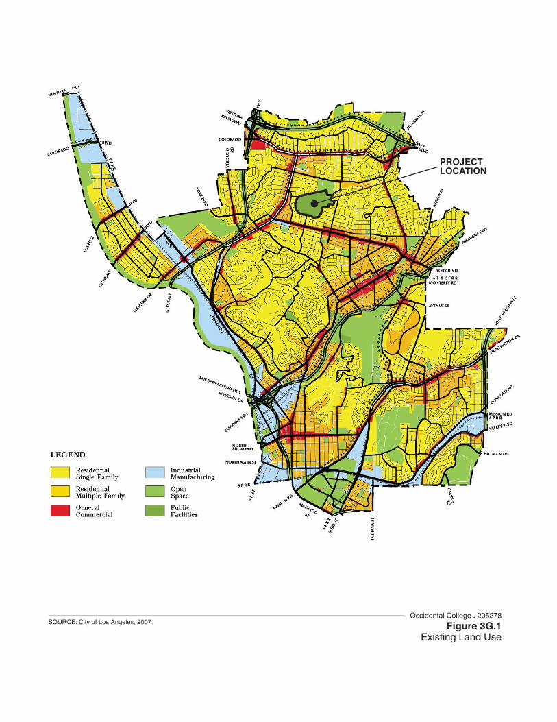
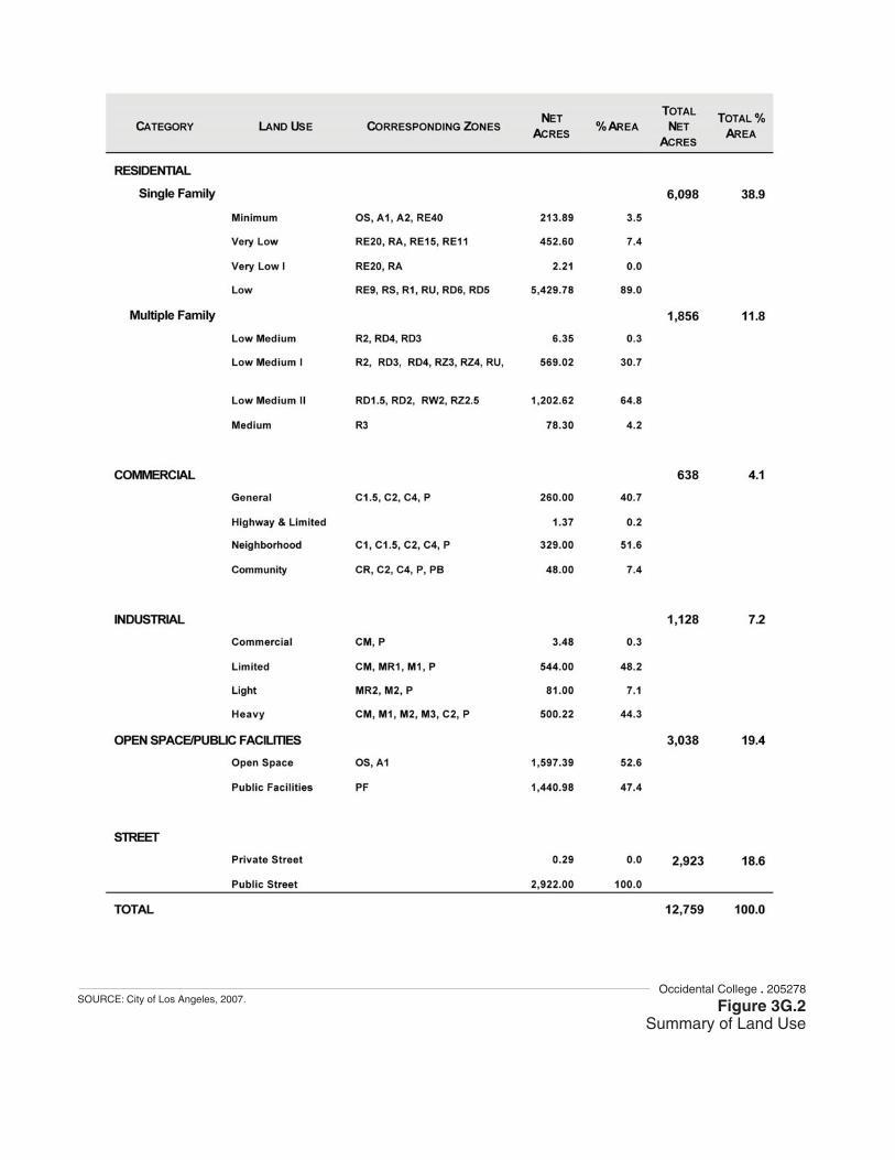
Regional Land Uses The Northeast Los Angeles Plan area covers a region of the City located at the far central eastern edge of the City. This area encompasses the communities of Eagle Rock, Glassell Park, Highland Park, Mount Washington, Cypress Park, Montecito Heights, Lincoln Heights, and El Sereno. Adjacent areas include the cities of Pasadena, South Pasadena, and Alhambra to the east, and the community of Eagle Rock. Residential land uses and open space are the predominant land use designated by the Northeast Los Angeles Plan area for the Eagle Rock community (see Figures 3G.1 and 3G.2). The existing pattern is characterized by single-family homes in hillside areas and a mixture of single- and multiple-residential dwellings on level lots. Open space in the area includes a long swath of open space along the north side of State Route 134 controlled by the Los Angeles Department of Water and Power, as well as other open space and parks throughout the Plan area.
Commercial land resources in northeast Los Angeles are concentrated in strips along thoroughfares separated from one another by the hilly terrain and residential communities. The commercial strips are developed more continuously and for greater length along the major and secondary highways, especially at the major intersections that were the historic commercial hubs of such long-recognized communities as Lincoln Heights, Highland Park, and Atwater Village. Commercial land uses are located primarily along Eagle Rock Boulevard, Colorado Boulevard, North Broadway, Huntington Drive, and York Boulevard. These uses range from national chain stores to small businesses.
Regional roadways include SR 134, which extends through the northern edge of the Eagle Rock community; SR 110, which extends through the south central Highland Park community; and SR 2, which extends along the western edge of the Eagle Rock community through the community of Glassell Park. In addition, Colorado Boulevard extends through the City of Pasadena through the Eagle Rock community, westward into the City of Glendale.
Regional land uses include the 120-acre Occidental College, located in the Community of Eagle Rock and the 200-acre Ernest C. Debs Regional Park, located near the community of Highland Park.
Occidental College . 205278
Figure 3G.1Existing Land Use
SOURCE: City of Los Angeles, 2007.
PROJECTLOCATION
Occidental College . 205278
Figure 3G.2Summary of Land Use
SOURCE: City of Los Angeles, 2007.
3. Environmental Setting, Impacts and Mitigation Measures 3G. Land Use and Planning
Occidental College Specific Plan 3G-4 ESA / D205278 Draft EIR September 2008
Community of Eagle Rock The Eagle Rock community is located in the City’s Northeast Los Angeles Community Plan area, adjacent to the incorporated cities of Glendale (northwest and west) and Pasadena (east), and the City of Los Angeles communities of Glassell Park (southwest) and Highland Park (southeast). Historically, as reflected in the General Plan (see Figures 3G-1 and 3G-2), land use in Eagle Rock and the Northeast Los Angeles Community Plan area are predominantly residential.
Occidental Campus Occidental College is composed of 53 major buildings on approximately 120 acres. In addition, the college owns and currently uses several buildings immediately adjacent to the main campus primarily for faculty housing, as well as staff offices, and meeting facilities. The western three-fifths of the campus is developed, while the more-hilly north and northwestern two-thirds of the campus is mostly undeveloped. In general, athletic facilities are located in a strip along Campus Road on the southern portion of the campus, academic facilities are located north of the athletic facilities. Further north are the residence halls, and at the eastern edge of the developed area are arts-related uses, parking, and the President’s House.
Along the western and southwestern perimeter of the campus, along Campus Road (between Westdale Avenue and Munson Avenue) are several of the college’s athletic facilities, including tennis courts; Patterson Field and Bill Henry Track, which is a stadium facility for both track and football that seats 2,600; and Bell Field, which includes facilities for softball. Between the stadium and Bell Field are several other athletic facilities, including gymnasiums, a sports center, pool, and field house. Additional athletic facilities are found along the southern perimeter of the campus, including a baseball diamond, playcourts, and soccer fields accessible from Rangeview Avenue and Coringa Drive.
Parking facilities are located to the north and far east of the developed campus center, accessible from Campus Road (between Ridgeview Avenue and Escarpa Drive) and from Rangeview Avenue and Coons Road, once on campus.
Alumni Avenue provides the main entrance onto the campus and first passes between Bell Field and the upper-level tennis courts, located along Campus Road. The campus chapel is located just off the Alumni Avenue entrance.
Residence halls cross the campus in a semi-arc that extends from Campus Road (near Coons Road) on the south to Campus Road again on the north (near Ridgeview Avenue). The residence halls separate academic uses from arts-related uses, including two theaters, the President’s House, and parking facilities located west of the residence halls. (One residence hall is located outside of this area at the northwestern Alumni Avenue and Campus Road.)
Surrounding Community Land uses to the east of the project site consist of single-family residential land uses, along the campus boundary. Yosemite Park and Yosemite Recreation Center, located at 1840 Yosemite
3. Environmental Setting, Impacts and Mitigation Measures 3G. Land Use and Planning
Occidental College Specific Plan 3G-5 ESA / D205278 Draft EIR September 2008
Drive; and the 3,000-student Eagle Rock High School, located at 1750 Yosemite Drive, are also near the northeastern perimeter. Additional residential land uses, located along Townsend Street, are also located along the northeastern perimeter.
Land uses to the west of the campus consist primarily of single-family residences, which are located along the north side of Campus Road. Single-family homes are also located along Ridgeview Avenue to the northwest and Escarpa Drive, which are perpendicular to Campus Road.
Land uses to the south consist of single-family residences, which are situated along the south side of Campus Road; and along the southern perimeter of the campus, along Avenue 51, Eaton Street, Coringa Drive, Rangeview Avenue, Avenue 49, Armdale Avenue, Munson Avenue, and Avenue 47.
The existing land use designation for the proposed project area is R1-1 (Single Family Residential – Low Density), as shown in Figure 3G.1.
3G.2 Regulatory Background Three principal documents govern land use on the project site: the City of Los Angeles General Plan Land Use Element, the Zoning Ordinance, and the Occidental College Master Plan. The project site is located in a fully urbanized area. No habitat conservation plan or natural community conservation plan applies to the proposed project site.
Occidental College is designated as an Educational Institution by Section 12.03 of the Los Angeles Municipal Code (LAMC).The proposed project also includes a Development Agreement with the City of Los Angeles.
Region
Southern California Association of Governments Regional Comprehensive Plan and Guide The County of Los Angeles is currently a member of the Southern California Association of Governments (SCAG). The Regional Comprehensive Plan and Guide (RCPG) combines the planning and policy work performed by the SCAG into one all-encompassing document. It serves as a reference to transportation commissions, environmental organizations, local governments, and other key planning stakeholders. The areas covered in the RCPG are: land use and housing; solid and hazardous waste; energy; air quality; open space and habitat; economy and education; water; transportation; security and emergency preparedness; and finance. Currently, SCAG is in the process of updating the RCPG.
Consistency of the project with relevant goals and objectives of the RCPG are discussed in the impact section below.

3. Environmental Setting, Impacts and Mitigation Measures 3G. Land Use and Planning
Occidental College Specific Plan 3G-6 ESA / D205278 Draft EIR September 2008
Local
City of Los Angeles General Plan The City of Los Angeles General Plan Framework serves as the blueprint for future growth and development in the City. The plan contains policies and programs designed to inform the public and developers of growth policies and to provide decision makers with a basis for decisions related to land use and development. The Land Use Element establishes the distribution and intensity of land use within the City with the goal of protecting residential neighborhoods and creating mixed-use urban environments oriented to transit and pedestrian activity.
The Land Use Element land use classifications are applicable to the proposed project, and permit specific uses for each applicable land use category. In addition, “For the purposes of developing, maintaining and implementing the land use portion of the General Plan, the City of Los Angeles has been divided into 35 community planning area. Plans for these 35 communities collectively comprise the Land Use Element of the General Plan.”1 The City of Los Angeles community plans provide more specific polices relevant to the City’s component communities. Policies in the General Plan Framework that are relevant to the proposed project are illustrated below in the Northwest Los Angeles Community Plan.
In addition the Transportation Element of the General Plan was developed to guide the development of a citywide transportation system that provides for the efficient movement of people and goods. The Transportation Element recognizes that primary emphasis must be placed on maximizing the efficiency of existing and proposed transportation infrastructure through advanced transportation technology, through reduction of vehicle trips, and through focusing growth in proximity to public transit. The City's Transportation Element is correlated with the Land Use Element, and is based on the recommendations of the Framework Element.2
Consistency of the project with relevant goals and objectives of the General Plan are discussed in the impact analysis below.
Northeast Los Angeles Community Plan
The Northeast Los Angeles Community Plan guides the general public, property owners, business interests and community-based organizations regarding the community’s goals, policies, and development standards, as established by the City Planning Commission and the City Council. The Plan thus communicates what is expected of both the public and private sectors to meet its objectives.
The Northeast Los Angeles Community Plan, is intended to promote an arrangement of land uses, streets, and services that will encourage and contribute to the economic, social, physical, and public health, safety, welfare, and convenience of the people who live, work and play in the
1 City of Los Angeles General Plan Framework, Housing Element, accessed at
http://www.ci.la.ca.us/PLN/Cwd/GnlPln/HsgElt/index.htm on April 22, 2008. 2 City of Los Angeles General Plan Framework, Transportation Element, accessed at
http://www.ci.la.ca.us/PLN/Cwd/GnlPln/TransElt/TE/T1Intro.htm#purpose on April 22, 2008.
3. Environmental Setting, Impacts and Mitigation Measures 3G. Land Use and Planning
Occidental College Specific Plan 3G-7 ESA / D205278 Draft EIR September 2008
community. The Northeast Los Angeles Community Plan is also intended to guide development in order to create a healthful and pleasant environment. The Plan features goals, objectives, policies, and programs to meet the existing and future needs and desires of the community. The Plan is intended to coordinate development among the various areas of the City of Los Angeles and adjacent municipalities in a fashion both beneficial and desirable to the residents of their communities and compatible with infrastructure and service levels. The Plan ensures sufficient land is designated to provide for the housing, commercial, employment, educational, recreational, cultural, social, and aesthetic needs of the residents of the Plan area. The Plan identifies and provides for the maintenance and protection of significant environmental resources within the Plan area. The Plan also seeks to recognize and enhance neighborhoods and communities within the Plan area.
Accordingly, the Northeast Los Angeles Community Plan serves the following purposes:
• Preserving and enhancing the positive characteristics of existing residential neighborhoods while providing a variety of compatible new housing opportunities.
• Improving the function, design, and economic vitality of the commercial districts.
• Preserving and enhancing the positive characteristics of existing uses and ensuring that future developments improve the identity and appearance of neighborhoods and communities by providing guidance regarding scale, height, bulk, setbacks, design, and landscaping.
• Regulating the development opportunities associated with the future rail transit system to maximize the economic potential while minimizing any adverse impacts.
• Revitalizing commercial and industrial development sites with needed job producing uses that improve the economic and physical condition of the Northeast Los Angeles Community Plan area.
The Northeast Los Angeles Community Plan also has the following Land Use goals, objectives and policies that guide land development in the region that also pertain to the proposed project. Relevant goals, objectives and policies from the Northeast Community Plan are discussed in the impact analysis below.
City of Los Angeles Zoning Code Zoning provides specific regulation for development. As required by law, the General Plan Land Use Element and the Zoning Ordinance should be consistent in order to ensure that long-term goals and objectives are implemented through land use regulations and other tools. The zoning ordinance and zoning designations of the land are primary tools implementing the City’s General Plan. In September 2001, the City of Los Angeles re-zoned the Occidental College campus from R-4 to R-1. The R-1 zoning allows a variety of single-family and two-family living quarters and accessory buildings with minimum lot sizes of 5,000 sf. Schools (including colleges) are currently permitted within this zoning district subject to issuance of a Conditional Use Permit (CUP). The College has previously obtained CUPs for the Hameetman Science Building (42,000 square feet) in July 16, 2002, and a residence hall (90,000 square feet, 274 beds and

3. Environmental Setting, Impacts and Mitigation Measures 3G. Land Use and Planning
Occidental College Specific Plan 3G-8 ESA / D205278 Draft EIR September 2008
235 parking spaces) in November 10, 2005. This zone also permits parks, playgrounds, truck farms, community centers, and home occupation uses.
Walkability Checklist
In August 2007 the Citywide Planning Commission approved and adopted the Walkability Checklist as a tool used during the approval process for projects in the City. The purpose of the Checklist is “to make developments more “walkable;” that is, to enhance pedestrian activity, access, comfort and safety”. The Checklist also encourages development to “protect neighborhood character and pursue high quality urban form”. Not every component or objective of the Walkability Checklist is applicable to every proposed development. Most often, the concept of “walkability” is applied to neighborhoods rather than a private college campus. As such, conventional measures of walkability, usually geared toward predominantly commercial and retail neighborhoods, do not entirely apply to an academic pedestrian environment. According to the International Physical Activity and the Environment Network (“IPEN”), walkable neighborhoods are those where one can walk or bike directly to multiple destinations. Hence two important factors in the “walkability index” established by IPEN for the purpose of evaluating the walkability of neighborhoods are street connectivity and mixed land uses: schools, homes, offices and shops are all within easy reach of each other. For purposes of CEQA review, it is, therefore, necessary to evaluate the walkability of an individual project within the context of its environmental setting. The measures of walkability described in Table 3G-2 (in the impact analysis following) are considered in terms of walkability within the campus as a whole, and also with respect to transitions into the surrounding residential neighborhood along the campus boundary. As such, analysis of the Specific Plan as a project refers to two categories—the internal campus, and the environment adjacent to the campus. The campus on the whole is an inherently walkable pedestrian zone, and this Specific Plan seeks to maintain the historical Myron Hunt composition of the campus by reducing vehicular activity within its boundaries. Moreover, the pedestrian zone was established as part of the original 1914 design and should be preserved as a historically significant campus element to be considered along with any future interests in walkability. If the surrounding residential neighborhood is not walkable, it would be unreasonable to unilaterally require the Specific Plan to transform the neighborhood into a walkable neighborhood in order to conform to the goals described in the Walkability Checklist. However, transitions into this neighborhood can be considered in terms of walkability enhancement. The college campus enjoys the elements of a learning neighborhood along with historically significant landscaping and pathways, inter-connecting academic buildings, and various athletic facilities. The college is surrounded by a low-density residential neighborhood, and its campus occupies approximately 120 acres. The campus accommodates a population of approximately 1,750 students and 700 staff with full academic and ancillary services including common areas, cafeterias, athletics facilities, clinic service, and residence halls. On campus, pedestrians enjoy a walkable environment traversed by numerous pathways covered with lush landscaping, most dating to the original establishment of the campus.
3. Environmental Setting, Impacts and Mitigation Measures 3G. Land Use and Planning
Occidental College Specific Plan 3G-9 ESA / D205278 Draft EIR September 2008
Pedestrian walkways and vehicle parking are available off the main gateway on Alumni Avenue, which then opens eastward onto a historic central campus. Within the central campus area the pathways are predominantly pedestrian with vehicles limited to facility maintenance. Likewise, Baer Road, Coons Road, Thorne Road, and Bird Road also provide limited parking access, but then transitions into predominantly pedestrian pathways towards the central areas of the campus. In addition to the wider pathways the campus is also riddled with numerous minor trails and pathways that are only accessible to pedestrian traffic. In the classical sense, walkability refers to neighborhoods with a variety of uses located within close proximity, and the campus does fit the spirit of this description. As customary for a collegiate campus, Occidental College is composed of various academic, athletic, residential, and ancillary uses. In contrast, the Specific Plan project area is surrounded by a neighborhood with predominantly low-density residential homes. With the exception of the commercial corridor along York and Eagle Rock Boulevards, no major shopping, dining, or entertainment uses are located within reasonable walking distance of the neighborhood. As mentioned above, Occidental College can be analyzed as two environments in terms of walkability—one internal to the campus and resulting from actions at the proposed “BOS” projects, and a separate environment occurring along the transition into the surrounding residential neighborhood.
Occidental College Planning Documents Occidental College has undertaken an extensive planning process to establish a long-term vision for the campus. For more than two years, the campus engaged in a broadly inclusive planning effort with the main goal of documenting a future for its educational program and facilities. In addition, the planning effort was created in order to further its academic mission, to be responsible to the communities that it serves, and to guide the College’s response to civic planning and related regulatory requirements. The process placed a premium on gauging needs of various kinds: the assessment of existing facilities, the demand for new ones, the response to experienced growth and the anticipation of future changes. It also facilitates the adjustment of existing and often outdated plans. Occidental College completed a Master Plan for the campus in 2007. The Master Plan is an internal document that addresses more than just the physical layout of the campus. The Master Plan is not subject to approval by the city of Los Angeles. As a result of the Master planning process Occidental College has prepared the Specific Plan that is the subject of this EIR. The Specific Plan and associated development Agreement are proposed for approval by the City of Los Angeles in order to plan for the future of the College and allow the College to meet the challenge of meeting future needs through 2025.
3G.3 Impacts and Mitigation Measures
Methodology Land use patterns and characteristics provide the basis for the evaluation of land use impacts. The proposed project is assessed to determine its consistency with local plans and policies to the greatest extent feasible.

3. Environmental Setting, Impacts and Mitigation Measures 3G. Land Use and Planning
Occidental College Specific Plan 3G-10 ESA / D205278 Draft EIR September 2008
Significance Criteria The criteria used to determine the significance of an impact are based on Appendix G of the CEQA Guidelines. For analysis, the proposed project may result in significant impacts if it would:
• Physically divide an established community;
• Conflict with any applicable land use plan, policy, or regulation of an agency with jurisdiction over the project (including, but not limited to the general plan, specific plan, or zoning ordinance) adopted for the purpose of avoiding or mitigating an environmental effect.
• Conflict with any applicable habitat conservation plan or natural community conservation plan.
Project Impacts The proposed Specific Plan divides Occidental College into three subareas. Figure 2.3 in the Project Description provides a graphic representation of these subareas. The division of these sub-areas is based upon a composite of physical characteristics, including topography, use, and the existing infrastructure of roads and parking. Current land uses and the proposed development for these three sub-areas are as follows:
Subarea 1- Edge, Entrance, and Public Transition
Description Subarea 1 (see Figure 2.3) wraps around the northwestern, eastern, and southern (including southwestern) portions of the campus located within 25 to 450 feet of the public street adjacent to the campus, from Baer Road and extending to Campus Road, Rangeview, Avenue 49, and Stratford Road. This area includes a series of single-family houses located adjacent to the southeast side of the campus and currently owned by the College. These houses are in use as residences for faculty and staff.
The southwest edge of campus also encompasses some of the campus athletic facilities located along the edge of the campus including Bell Field, the chapel, the upper level tennis courts, and a portion of the entrance, located at Alumni Avenue and Campus Road.
Allowable Development Under the Specific Plan, an estimated 211,980 sf of development would be added to the existing 126,302 gross sf for a proposed maximum development total of 338,282 sf.
Permitted Uses • Academic (AC)
• Adaptive Reuse (any adaptive reuse of one of Myron Hunt’s original buildings retaining the historic features of the building is permitted in any Entitlement Area.
• Administration/Facilities (AD)
• Arts (AR)
3. Environmental Setting, Impacts and Mitigation Measures 3G. Land Use and Planning
Occidental College Specific Plan 3G-11 ESA / D205278 Draft EIR September 2008
• Athletic (AT)
• Common (C)
• Residential (R) (Faculty/staff multi-family housing)
Subarea 2 – Heritage and Academic
Description Subarea 2 (see Figure 2.3) consists of the built areas of the campus. Buildings in the southern portion of this area principally serve academic, student commons, and administrative uses. These buildings include Academic, Administration/Facilities, Arts, Athletic, Commons, and Residence Halls. The topography of this sub-area is flat in the Main Quadrangle and slightly sloping toward the upper edges. The majority of buildings here are arranged around three formal devices: (a) the walkway/axis which extends from Thorne Hall to Wylie Hall/Hameetman Science Center, (b) the Alumni Avenue axis which aligns with the Coons Administration Building, and (c) the main quadrangle space, which is embraced by the Clapp Library, Johnson, Fowler and Swan halls, Johnson Student Center, and Herrick Chapel. Bird Road and Emmons Road help define the character of significant portions of the upper edge of this sub-area.
Buildings in the northern portion of this area principally include residential uses, including Wylie Hall and Bell-Young Hall, Newcomb, Erdman, Chilcott, Haines, Stearns, Norris, Braun, Stewart Cleland, and Pauley halls, and the President's house; selected academic facilities, including the Mullin sculpture studios and Weingart Center classrooms; and common facilities, including the Admissions Office, Early Learning Center, Emmons Health Center, and the Samuelson Pavilion. Bird Road defines most of the lower edge of the area; topography generally slopes uphill from there. Portions of Sycamore Glen are also included in this sub-area.
This area also includes the performing arts uses of the Keck Center and Remson Bird Hillside Theater, a new student residence hall and an Environmental Policy Institute, Anderson Field, and one athletic (soccer) field.
Allowable Development Under the Specific Plan, up to approximately 550,250 gross sf of new development can be added to the existing 1,021,742 gross sf of development for a Base Allowable Development total of 1,571,992 sf. (This area would include removal of some buildings.)
Permitted Uses • Academic (AC)
• Adaptive Reuse (any adaptive reuse of one of Myron Hunt’s original buildings retaining the historic features of the building is permitted in any Entitlement Area.
• Administration/Facilities (AD)
• Arts (AR)
• Athletic (AT)
• Common (C)
3. Environmental Setting, Impacts and Mitigation Measures 3G. Land Use and Planning
Occidental College Specific Plan 3G-12 ESA / D205278 Draft EIR September 2008
• Residential (R) (Faculty/staff multi-family housing; student housing)
Subarea 3 – Residential and Active Recreation
Description Subarea 3 consists of undeveloped and mostly hilly land. The north edges of this area face portions of Avenue 50, Townsend Avenue, and residential neighborhoods. One athletic field is currently included in Subarea 3 (the upper soccer field).
Allowable Development Under the Specific Plan, 95,450 gross sf may be built in this subarea for a Base Allowable Development of 95,450 sf.
Permitted Uses • Athletic (AT) • Common (C) (Building of approximately 1,000 sf or less) • Residential (R) (including faculty/staff multi-family housing)
Land Use Plans Consistency Analysis The following goals, objectives and policies from the General Plan and Northeast Community Plan are applicable to the project:
General Plan
Historic and Cultural
Goal 3M: A City where significant historic and architectural districts are valued.
Objective 3.17: Maintain significant historic and architectural districts while allowing for the development of economically viable uses.
Policy 3.17.2: Develop other historic preservation tools, including transfer of development rights, adaptive re-use, and community plan historic preservation policies.
Project: The project would conform to land use policies from the General Plan General Framework that relate to maintaining and reusing potentially historic structures by proposing adaptive re-use of historic buildings and features. Potentially historic structures will be both maintained and altered, but would be required to conform to the Secretary of the Interior’s Standards (see Section 3D, Cultural Resources, Measure 3D.1).
Neighborhood Improvements, Livability
Goal 5A: A liveable City for existing and future residents and one that is attractive to future investment. A City of interconnected, diverse neighborhoods, that builds on the strengths of those neighborhoods and functions at both the neighborhood and citywide scales.

3. Environmental Setting, Impacts and Mitigation Measures 3G. Land Use and Planning
Occidental College Specific Plan 3G-13 ESA / D205278 Draft EIR September 2008
Objective 5.4: Encourage the development of community facilities and improvements that are based on need within the centers and reinforce or define those centers and the neighborhoods they serve.
Policy 5.4.1: Encourage the design of existing and new schools for multiple functions, including, but not limited to, the following:
a. Design of schoolyards to be used as parks accessible to surrounding neighborhoods. b. Design of school libraries to be used as community libraries, where feasible; and c. Design of school auditoriums to be used as community meeting rooms.
Policy 5.4.4: Encourage the use of community facilities for nighttime activity through the use of appropriate roadway and pedestrian area lighting.
Objective 5.5: Enhance the liveability of all neighborhoods by upgrading the quality of development and improving the quality of the public realm.
Policy 5.5.3: Formulate and adopt building and site design standards and guidelines to raise the quality of design Citywide.
Project: With phased, planned development, and the use of LEED standards, the Specific Plan would ensure that Occidental College remains an attractive investment for the college and that it underpins the value of adjacent neighborhoods. The campus would remain open to nearby residents (Policy 5.4.1), and, as a Tier 1 liberal arts college, would continue to contribute to the region’s highly qualified labor force (Goal 7E). By providing staff, faculty, and student housing, the project would release other off-campus housing needed by Los Angeles residents.
Open Space
Goal 6A: An integrated citywide/regional public and private open space system that serves and is accessible by the City’s population and is unthreatened by encroachment from other land uses.
Objective 6.4: Ensure that the City’s open spaces contribute positively to the stability and identity of the communities and neighborhoods in which they are located or through which they pass.
Policy 6.4.7: Consider as part of the City’s open space inventory of pedestrian streets, community gardens, shared school playfields, and privately-owned commercial open spaces that are accessible to the public, even though such elements fall outside the conventional definitions of “open space.” This will help address the open space and outdoor recreation needs of communities that are currently deficient in these resources (see the Recreation and Parks section in Chapter 9: Infrastructure and Public Services).
3. Environmental Setting, Impacts and Mitigation Measures 3G. Land Use and Planning
Occidental College Specific Plan 3G-14 ESA / D205278 Draft EIR September 2008
Project: The project is a private institution that provides open space and recreational opportunities to the surrounding community. It is not anticipated that BOS 7 (lower soccer field) would be removed, however if it were developed with above-grade parking, on-campus recreational facilities would continue to meet the needs of students and staff. The Specific Plan would not impact the availability of the campus as an open space resource for the community. Most of Subarea 3 will continue in its current natural open space state.
Labor Force
Goal 7E: A City with a highly qualified labor force.
Objective 7.7: Achieve an effective “match” between the qualifications of the local labor forces and the anticipated personnel requirements of existing and emerging industries in the City.
Objective 7.7.1: Expand job training programs offered in the City to more adequately address the skill requirements of existing and emerging industries.
Project: As a prestigious liberal arts college, Occidental College provides educational opportunities to Los Angeles residents and the greater community. The College also provides courses open to others. Occidental's Community Literacy Center provides one-on-one reading and writing instruction for 50 K-6 students from the surrounding community. Each year, Occidental’s Upward Bound program helps more than 100 low-income high school students become the first person in their family to attend college. Through Gaining Early Awareness And Readiness for Undergraduate Programs (GEARUP) Occidental’s students provide tutoring and mentoring services to students at Eagle Rock and Marshall high schools. TOPS (Teachers+Occidental = Partnership in Science) has trained high school science teachers the latest biology, chemistry and physics concepts and provided their students with advanced scientific equipment for hands-on lab experience in the program's mobile laboratory. Occidental also hosts a variety of UCLA Extension classes.
Housing Opportunities
Goal 7G: A range of opportunities in the City.
Objective 7.9: Ensure that the available range of housing opportunities is sufficient, in terms of location, concentration, type, size, price/rent range, access to local services and access to transportation, to accommodate future population growth and to enable a reasonable portion of the City’s work force to both live and work in the City.
Project: The Specific Plan seeks to provide housing for staff members who have historically had a difficult time finding affordable housing in close proximity to the College.
3. Environmental Setting, Impacts and Mitigation Measures 3G. Land Use and Planning
Occidental College Specific Plan 3G-15 ESA / D205278 Draft EIR September 2008
Northeast Los Angeles Community Plan
Neighborhood Preservation, Historic Preservation
Goal 1: A safe, secure, and attractive residential environment for all economic, age, and ethnic segments of the community.
Objective 1-1: To preserve and enhance existing residential neighborhoods.
Policy 1-1.2: Promote neighborhood preservation, particularly in existing single-family neighborhoods, as well as in areas with existing multiple-family residences.
Objective 1-3: To preserve and enhance the residential character and scale of existing single- and multi-family neighborhoods.
Policy 1-3.1: Protect the quality and scale of the residential environment through attention to the appearance of new construction including site planning and compatible building design.
Policy 1-3.2: Consider factors, such as neighborhood character and aesthetics identity, compatibility of land uses; impacts on livability, services, public facilities, and traffic levels, when changes in residential densities are proposed.
Objective 1-4: To preserve and enhance neighborhoods with a distinctive and significant historical or architectural character.
Policy 1-4.1: Encourage identification and documentation of historic and architectural resources in the Plan area.
Program: The Plan map will be updated when historic districts, historic preservation zones, or National Register Historic Districts are designated.
Program: City agencies will actively assist local efforts to identify historic and architectural districts.
Policy 1-4.2: Protect and encourage reuse of historic resources in a manner that maintains and enhances the historic appearance of structures and neighborhoods.
Program: The Plan encourages adaptive re-use of historic buildings when the proposed uses are found to be compatible with existing residential uses.
Program: The Departments of Building and Safety and City Planning will continue to maintain an inventory of residential structures proposed for demolition for use by those interested in relocating them.
Policy 1-4.3: Preserve architecturally or historically significant features, such as designated trees and stone walls and incorporate such features as an integral part of new development when appropriate.
Program: Historic Preservation Overlay Zone(s) can define resources broadly to include such features as significant trees and stone walls and provide appropriate protection measures.

3. Environmental Setting, Impacts and Mitigation Measures 3G. Land Use and Planning
Occidental College Specific Plan 3G-16 ESA / D205278 Draft EIR September 2008
Project: The Specific Plan seeks to enhance the existing college. The existing college is an attractive campus with historic buildings and mature vegetation. Most changes to the campus will be internal to the campus and not visible to the community. In addition to specific height limits and development restrictions and standards within each Sub-Area of the Specific Plan, no new building or structure in any Subarea and located within 25-feet of a historically sensitive building would be allowed to exceed the height of the eves of the adjacent historically significant building. Potentially historic buildings and the historic nature of the campus will be protected and preserved (see Measure 3D.1). The college is a premiere institution that adds to the character of the community.
Density, Hillside Development, Open Space
Objective 1-5: To limit the intensity and density of development in hillside areas.
Policy 1-5.1: Limit development according to the adequacy of the existing and assured street circulation system within the Plan Area and surrounding areas.
Program: The Plan Map significantly reduces plan designations and corresponding zones in areas located at the base of hillside communities previously designated Medium density residential to reduce impact on access in hillside areas.
Program: Implementation of the Plan is, in part, based on continued application of the Citywide Hillside Ordinance and the Mount Washington/Glassell Park Specific Plan.
Policy 1-5.2: Ensure the availability of paved streets, adequate sewers, drainage facilities, fire protection services and facilities, and other emergency services and public utilities to support development in hillside areas.
Program: Decision makers should adopt findings which address the availability of these services and utilities as part of any decision relating to hillside residential development.
Program: Continue the implementation of the Citywide Hillside Ordinance.
Policy 1-5.3: Consider the steepness of the topography and the geologic stability in any proposal for development within the Plan area. Program: The Plan Map retains restrictive land use designations and zones in hillside areas because of topography, geologic stability, and restricted access.
Policy 1-5.4: Require that any proposed project development be designed to enhance and be compatible with adjacent development.
Goal 4: Sufficient open space, in balance with development, to serve the recreational, environmental, and health needs of the community and to protect environmental and aesthetic resources.
Objective 4-1: To preserve existing views in hillside areas.
Policy 4-1.1: Encourage the retention of passive and visual open space which provides a balance to the urban development of the Plan area.
3. Environmental Setting, Impacts and Mitigation Measures 3G. Land Use and Planning
Occidental College Specific Plan 3G-17 ESA / D205278 Draft EIR September 2008
Goal 6: Appropriate locations and adequate facilities for schools to serve the needs of existing and future population.
Objective 6-1: To site schools in locations complementary to existing land uses and community character.
Policy 6-1.1: Encourage compatibility in school locations, site layout, and architectural design with adjacent land uses and community character; use schools, as appropriate, to create logical transitions and buffers between uses such as multiple-family and single-family residential or commercial and residential land uses.
Project: The Occidental College has established at this site since 1914. It occupies a sloping campus that contains significant elevation changes on the eastern third of the campus. Development in the hillside areas would be limited and would conform to existing grade (with the exception of BOS 5, which whether developed as a play field or housing site would require about 20,000 cubic yards of grading to achieve a level site). The project would not result in a substantial change in the student population. Rather the Specific Plan is aimed at upgrading the existing campus. The maximum student body would remain as at present (2000). This EIR analyzes an increase of 250 students from 2007 student population to the allowed maximum of 2000. The street system is adequate to support the traffic, with the exception of potential neighborhood street impacts if 232 parking spaces are concentrated at BOS 28, thereby potentially concentrating traffic in that area. It is not anticipated that BOS 7 (lower soccer field) would be removed, however if it were developed with above-grade parking, on-campus recreational facilities would continue to meet the needs of students and staff. While the Specific Plan does allow for new development up to 75 feet in height (compared to the maximum 45 feet allowed in the R-1 zone), this height is proposed to be allowed only in Subarea 2 and outside the 80-foot setback from Campus Road in Sub-Area 1, in both instances internal to the site.
Police Protection
Policy 8-1.1: Coordinate with Police Department as part of the review of significant development projects and General Plan Amendments affecting land use to determine the impact on service demands.
Program: A decision-maker should include a finding which considers the impact on police service demands of the proposed project or land use plan change. This consultation with the Police Department is currently in effect for plan amendments which must be reviewed by the General Plan Advisory Board, which includes representation from the Police Department.
Policy 8-1.3: Encourage design of building and facilities in accordance with principles that minimize opportunities for crime and enhance personal safety.
Program: The Plan contains Design Guidelines (Chapter V) that incorporate and promote crime prevention strategies developed by the Police Department.
Project: The project is the upgrade of an existing (premiere liberal arts) college campus. Occidental College is very concerned about safety on their campus and in the vicinity. Occidental would continue to coordinate with the Police Department.
3. Environmental Setting, Impacts and Mitigation Measures 3G. Land Use and Planning
Occidental College Specific Plan 3G-18 ESA / D205278 Draft EIR September 2008
Non Motorized Transportation
Policy 13-1.1: Assure that local bicycle routes are identified and linked with routes of neighboring areas of the City.
Program: The Plan Map identifies the following as bikeway routes: 1) one starting from Riverside Drive and following the bank of the Los Angeles River to Forest Lawn Drive; 2) one beginning at the intersections of Figueroa Street and San Fernando Road, following Pepper Avenue, Cypress Avenue, Eagle Rock Boulevard, and running east and west along Colorado Boulevard 3) one generally following the Pasadena Freeway and Griffin Avenue; and 4) one following Huntington Drive between the City of Alhambra Boundary and Mission Road and 5) one following the Department of Water and Power easement within the Taylor Yard. Coordinate with the ongoing revision and updating of the Citywide Bicycle Plan to insure implementation of this policy.
Policy 13-1.2: Encourage the provision of showers, changing rooms and bicycle storage at new and existing non-residential developments and public places.
Program: Through the inclusion of this policy in the Plan text, the Plan supports the provision of bicycle facilities particularly in pedestrian oriented areas and Transit-Oriented Districts and recommends that this policy be considered, in the revision of the Citywide Bicycle Plan. In addition, Los Angeles Municipal Code Sections 12.21 A 16 and 91.0705 provide for bicycle parking requirements and employee facilities for showers and lockers.
Project: The project involves upgrades to an existing college campus. The campus already encourages students to walk and bicycle around the campus and community. Attractive walkways and internal circulation would be maintained under the project.
Table 3G-1 compares relevant sections of the Los Angeles Municipal Code to the Specific Plan. The Specific Plan would differ in nearly every aspect from the current zoning of the project site, because much of the applicable zoning is specifically designed for residential use. The differences between zoning designed for residential use and a private college, as illustrated by Table 3G-1 are reasonable for a Specific Plan designed for a privately-owned educational institution located in an urban environment. The Specific Plan promotes clustering (much of the development is in areas with existing development), which in turn promotes larger open spaces, both along the edges of the campus and internally. Development of residences in the northeast portion of the Specific Plan are in an area previously undeveloped, but adjacent to an urbanized area, near public facilities and residences. Multi-family housing (faculty and staff) is proposed on BOS 1, 2, 3 and potentially 5. This housing would be across N. Avenue 50 from single family housing in an R-1 zone. The housing would be designed to fit in with the adjacent neighborhood. Even with the proposed development in the northeast portion of the campus, most of Subarea 3 would remain undeveloped.
The proposed Specific Plan would require an amendment to the Municipal Code and the General Plan. This is not, of itself, an environmental impact, but is instead a legislative act by the decision-makers. The physical effects of the change to the environment are evaluated throughout this DEIR. The adoption of the Specific Plan as a legislative act would be a less than significant effect.

3. Environmental Setting, Impacts and Mitigation Measures 3G. Land Use and Planning
Occidental College Specific Plan 3G-19 ESA / D205278 Draft EIR September 2008
TABLE 3G-1 COMPARISON OF RELEVANT SECTIONS OF THE LOS ANGELES MUNICIPAL CODE TO
THE SPECIFIC PLAN
LAMC SPECIFIC PLAN
LAMC Sec.11.5.7 F
Director of Planning Determinations for Exceptions from the Specific Plan are appealed first to the Area Planning Commission, and then to the City Council.
Specific Plan Sec. 3.D
Director's determinations on Specific Plan exceptions are appealed directly to the City Council.
LAMC Sec.12.08 A.6
Educational Institutions (such as Occidental College) are authorized pursuant to Conditional Use approval (per LAMC Sec. 12.24) in the R1 Zone, which allows Single-Family Residential uses by right. Additional uses may be permitted by Variance.
Specific Plan Sec. 8.B
The Specific Plan allows facilities/uses included as part of an Education Institution, which would normally only be allowed by Conditional Use or Variance in the R-1 Zone.
LAMC Sec.12.21.1 A
Square footage is authorized according to buildable area at a 3:1 FAR.
Specific Plan Sec. 8.D
Square footage is authorized for 1,698,294 sf (approx 0.32 FAR).
LAMC Sec.12.21 1
LAMC Code height in the R1 zone is limited to 45 feet.
Specific Plan Sec. 9.C 1 & 2
Height would be limited to 45 feet in Subarea 3, BOS 7, and within the 30-to-80 foot setback in Sub-Area 1, but is proposed to be allowed up to 75 feet in Subarea 2.
LAMC Sec.12.21.1
Mechanical Penthouses and other roof structures are not permitted to exceed 10 feet.
Specific Plan Sec. 9.C 3 & 4
Mechanical penthouses are limited to 20 feet.
LAMC Sec.12.03 (Definitions for Basement & Story)
A basement, cellar or unused underfloor space shall be considered a story if the finished floor level directly above a basement, cellar or unused underfloor space is more than six feet above grade for more than 50% of the total perimeter, or is more than twelve feet above grade.
Specific Plan Sec. 9.C.5
Floor up to one-half of a story beneath the averaged grade are not considered a basement area. Floors beneath the depressed half-story are considered a basement.
LAMC Sec.12.23
Non-conforming height structures are not permitted to enlarge or add more than 50% of the existing ground floor area. Any new construction must conform to existing codes.
Specific Plan Sec. 9.C.6
Existing structures are authorized to retain non-conforming heights and rebuild, renovate, add, and alter without losing the non-conforming height.
LAMC Sec.17.05 H
LAMC Code requires lot coverage calculation based on lot lines, Tentative Tract Maps or Vesting Tentative Tract Maps.
Specific Plan Sec. 9.D
The Unified Development code addresses guidelines for FAR, but the Specific Plan also allows lot coverage and yard requirement averaging across the campus.
LAMC Sec.12.08 B
Setbacks in the R1 zone are: front yard of not less than 20% the depth of the lot, not to exceed 20'; side yards of 5' plus one additional foot per each story above the 2nd story; and rear yard of not less than 15'.
Specific Plan Sec. 9.E.1
Setbacks have been removed, except for those facing public streets (no rear yard, side yard, or internal street setbacks).
LAMC Sec.12.23
Setbacks for existing nonconforming buildings are lost if more than 50% of the nonconforming building's perimeter walls are removed.
Specific Plan Sec. 9.E.3
Setbacks currently established are retained even after entire building’s replacement.
LAMC Sec.12.21 A
Under the LAMC, parking requirements are calculated by a unit of measurement per each use (i.e., 1 space per 5 seats for an auditorium, or 2 spaces per single-family residence).
Specific Plan Sec. 11
Parking requirements in the Specific Plan are based on projected parking demand, as calculated in the campus parking survey. Parking for new employee housing (2 spaces per unit) will be added in a manner similar to the LAMC.
SOURCE: Los Angeles Municipal Code, 2008; Occidental Specific Plan, 2008.
3. Environmental Setting, Impacts and Mitigation Measures 3G. Land Use and Planning
Occidental College Specific Plan 3G-20 ESA / D205278 Draft EIR September 2008
Consistency with the RCPG Chapter: Land Use.
Outcome: Vehicle Miles Traveled per Household. Description: Measures household vehicle usage as a proxy for jobs/housing balance, urban design, transit accessibility, and other urban form issues. The assumption is that a functioning urban form results in less vehicle usage. Measures at regional scale measured to plan horizon year (2035).
Outcome: Green Building. Description: Outcome measures implementation of green building standards as part of local planning and permitting. Initial Proposed Quantified Outcome: 30% of jurisdictions adopt green building standards.
Chapter: Economy
Growth in the region’s economic prosperity should be shared broadly by residents throughout the region. Regional policy makers need to be concerned wit: competitive work force; efficient infrastructure; quality of life. Attracting, retaining, educating and training a diverse labor force has become an increasingly important objective for regional economies.
Project: The proposed Specific Plan would conform to SCAG’s policies on green housing; the proposed project would include LEED equivalent (silver) and would conform to the City of Los Angeles Green Building Ordinance (see Section 3.B Air Quality, Measure 3.B.5). New residences for faculty/staff, would reduce vehicle miles traveled in the region. As a part of the regional economy, the Specific Plan would ensure the college’s continued contribution to the region’s economic prosperity by attracting, educating, and training a diverse labor force. In addition, the Specific Plan would ensure an organized, predictable approach to future development, which supports goals to improve the quality of life.
Consistency with Walkability Checklist
It is the intent of the Specific Plan to expand on the walkability of the campus while retaining the integrity of the existing historical composition of the campus. Within the Specific Plan, 29 Building Opportunity Sites are identified as suitable for development, although specific building designs have not yet been identified. The Specific Plan will address the needs of future campus development according to a Unified Development Agreement and Master Plan. As such, the campus will incorporate future development according to these agreements while retaining the integrity of the existing historical context. In total, the campus is walkable in overall design, although portions of individual buildings or Building Opportunity Sites may be incompatible (i.e. a direct path from one building to another may not always be possible). In order to provide continuum and to further enhance walkability across the campus, future development would strike a balance between the needs to preserve the existing historical fabric and elements of walkability. Also, compliance with the Americans with Disabilities Act would be balanced with walkability considerations when constructing future buildings.
3. Environmental Setting, Impacts and Mitigation Measures 3G. Land Use and Planning
Occidental College Specific Plan 3G-21 ESA / D205278 Draft EIR September 2008
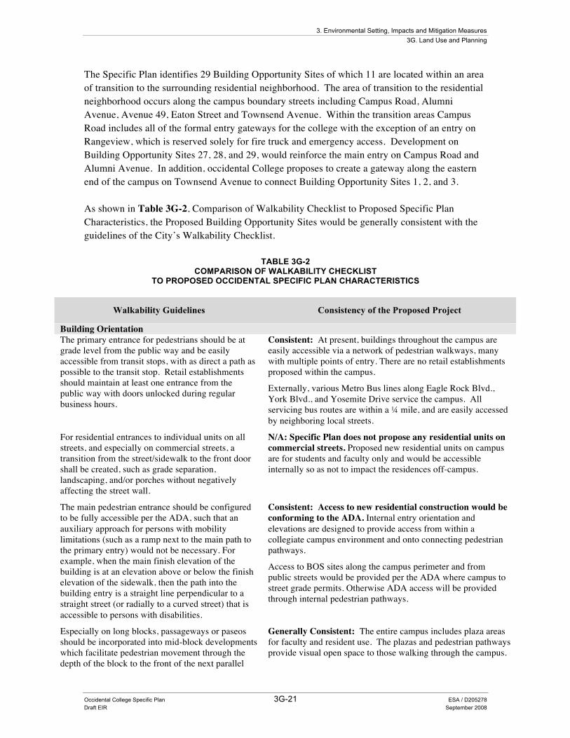
The Specific Plan identifies 29 Building Opportunity Sites of which 11 are located within an area of transition to the surrounding residential neighborhood. The area of transition to the residential neighborhood occurs along the campus boundary streets including Campus Road, Alumni Avenue, Avenue 49, Eaton Street and Townsend Avenue. Within the transition areas Campus Road includes all of the formal entry gateways for the college with the exception of an entry on Rangeview, which is reserved solely for fire truck and emergency access. Development on Building Opportunity Sites 27, 28, and 29, would reinforce the main entry on Campus Road and Alumni Avenue. In addition, occidental College proposes to create a gateway along the eastern end of the campus on Townsend Avenue to connect Building Opportunity Sites 1, 2, and 3. As shown in Table 3G-2, Comparison of Walkability Checklist to Proposed Specific Plan Characteristics, the Proposed Building Opportunity Sites would be generally consistent with the guidelines of the City’s Walkability Checklist.
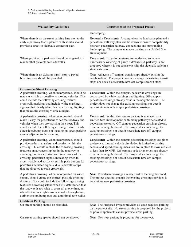
TABLE 3G-2 COMPARISON OF WALKABILITY CHECKLIST
TO PROPOSED OCCIDENTAL SPECIFIC PLAN CHARACTERISTICS
Walkability Guidelines Consistency of the Proposed Project
Building Orientation The primary entrance for pedestrians should be at grade level from the public way and be easily accessible from transit stops, with as direct a path as possible to the transit stop. Retail establishments should maintain at least one entrance from the public way with doors unlocked during regular business hours.
Consistent: At present, buildings throughout the campus are easily accessible via a network of pedestrian walkways, many with multiple points of entry. There are no retail establishments proposed within the campus.
Externally, various Metro Bus lines along Eagle Rock Blvd., York Blvd., and Yosemite Drive service the campus. All servicing bus routes are within a ¼ mile, and are easily accessed by neighboring local streets.
For residential entrances to individual units on all streets, and especially on commercial streets, a transition from the street/sidewalk to the front door shall be created, such as grade separation, landscaping, and/or porches without negatively affecting the street wall.
N/A: Specific Plan does not propose any residential units on commercial streets. Proposed new residential units on campus are for students and faculty only and would be accessible internally so as not to impact the residences off-campus.
The main pedestrian entrance should be configured to be fully accessible per the ADA, such that an auxiliary approach for persons with mobility limitations (such as a ramp next to the main path to the primary entry) would not be necessary. For example, when the main finish elevation of the building is at an elevation above or below the finish elevation of the sidewalk, then the path into the building entry is a straight line perpendicular to a straight street (or radially to a curved street) that is accessible to persons with disabilities.
Consistent: Access to new residential construction would be conforming to the ADA. Internal entry orientation and elevations are designed to provide access from within a collegiate campus environment and onto connecting pedestrian pathways.
Access to BOS sites along the campus perimeter and from public streets would be provided per the ADA where campus to street grade permits. Otherwise ADA access will be provided through internal pedestrian pathways.
Especially on long blocks, passageways or paseos should be incorporated into mid-block developments which facilitate pedestrian movement through the depth of the block to the front of the next parallel
Generally Consistent: The entire campus includes plaza areas for faculty and resident use. The plazas and pedestrian pathways provide visual open space to those walking through the campus.

3. Environmental Setting, Impacts and Mitigation Measures 3G. Land Use and Planning
Occidental College Specific Plan 3G-22 ESA / D205278 Draft EIR September 2008
Walkability Guidelines Consistency of the Proposed Project
block, such that pedestrians need not walk the circumference of a block in order to access the middle of the next parallel block or alley or parking behind the block.
The predominant development pattern for the surrounding neighborhood is single-family residential which does not normally provide for pedestrian passage between streets. The public street boundary of Sub-Area 1 provides four formal gateways in and out of the campus. Any potential perimeter BOS project will be generally consistent as it is a college campus, and will connect to mid-block access currently provided through various intersecting pedestrian pathways. The Specific Plan is for a college campus and is not considered a mid-block development.
Where incorporated, mid-block passageways or paseos should be active, visually interesting spaces, and safe. Activities could include: building entrances; windows; seating; dining; water features; kiosks; vending or displays. Visually interesting features could include: colors; textures; architectural elements; public art; pedestrian-level lighting.
Consistent: The Specific Plan is not within a retail/commercial development area. Individual building opportunity sites within the Specific Plan would connect and extend onto a network of existing passageways, paseos, and visually attractive landscapes that complement the existing collegiate campus environment.
Features such as outdoor dining would be inappropriate if placed adjacent to the surrounding single-family residential neighborhood. Those BOS that are adjacent to the public street and boundary of the specific plan will be designed to have visually attractive pathways, campus entrances, and building façades for both pedestrian and vehicular use.
Building Frontage The façade should include a variety of features such as: a combination of different textures, colors and materials; distinctive architectural features; display windows; signage; setbacks and differentiated massing; rooflines; shade and shadow textures.
Consistent. Internal building façades are accented with architectural details, materials, textures, colors, porticos, rooflines, and signage. Some of the existing building façades are of historical interest and will influence features in adjacent BOS projects.
As outlined in the Occidental College Specific Plan Section 9.B Design Guidelines, building façades, garden walls, and street frontage will incorporate architectural articulation to enhance the public street pedestrian experience.
The façade should create or reinforce an existing façade rhythm.
Consistent: The neighborhood surrounding the Specific Plan includes a mixture of one and two story residential structures. BOS that are located directly along the perimeter of the Specific Plan will benefit from improved landscaping, garden walls, and architectural details on building facades.
The pedestrian and visual experience will be further improved compared to the existing off-campus conditions.
Upper floors should be differentiated from the ground floor.
Consistent: The architectural designs within the campus environment would incorporate portico and colonnade entrances along with differentiating architecture in the upper floors.
There should be no blank walls. Walls should be interesting facades by incorporating a combination of elements such as: sculpted, carved or penetrated wall surface; planters; murals; mosaics; public art; awnings; lighting.
Consistent. The proposed project would not include any blank walls. In keeping with the campus design, buildings will incorporate various architectural details and façades.

3. Environmental Setting, Impacts and Mitigation Measures 3G. Land Use and Planning
Occidental College Specific Plan 3G-23 ESA / D205278 Draft EIR September 2008
Walkability Guidelines Consistency of the Proposed Project
The building frontage should include overhead architectural features, such as awnings, canopies, trellises or cornice treatments.
Consistent: Building designs have not yet been identified, but the overall project would include multiple buildings with significant architectural details, articulated façade treatments, and eaves.
At corners, the building frontage should consider building cutoffs in response to any need to accommodate pedestrians and to protect pedestrian safety, security and enjoyment.
Consistent: The overall campus design would protect pedestrian safety, security and enjoyment.
Any spaces created by setbacks, building cut-offs and/or breaks in exterior walls should be turned into active spaces, such as active plazas or courtyards (activities could include: dining; seating; water features; kiosks; vending or displays). Where appropriate given the character of the street and a sidewalk that is narrower than desired, the setback should be increased to create more space for such active plazas or courtyards and/or additional pedestrian amenities or landscaping.
Consistent. As a unified development the campus and proposed projects provide more plazas, paseos, and courtyards than is normally available within standard setbacks, including ample space for pedestrian walkways and landscaping.
Beyond the campus boundary the existing neighborhood is primarily single-family residential with some multi-family residential uses. Consequently, “active plazas or courtyards” (with activities such as: dining; seating; kiosks; vending or displays), which are more appropriate to mixed-use and dense urban environments are not applicable to the environmental setting of the proposed project.
Where there are breaks or openings in the ground floor building façade, architectural features should be applied to create continuity across the break(s).
Consistent: For the campus entrances on Alumni Road, the proposed project would provide continuity in the building façades with the use of garden walls, architectural details and landscaping.
The building should be placed at the front property line or at the required setback; that is, the building should not be set back further than the required setback in order to be as close as possible to the front property line and maintain a strong street wall.
Consistent. The proposed project would provide a larger set-back than is required in order to provide ample space for pedestrian walkways and landscaping.
Building Frontage Canopy trees (in addition to street trees) should be provided in landscaped areas. For example, a row of trees could be provided on both sides of the sidewalk.
Consistent: Where appropriate street trees would be included in the sidewalk, and trees would be included in the planter area between buildings and pathways to create a pleasant pedestrian experience.
Landscaping should not impede pedestrian movement or views. For example, avoid tall shrubbery immediately adjacent to the sidewalk.
Consistent: Standard street tree varieties would be used to create a canopy that would provide shade for walk ways.
Trees should be considered especially where such additional vertical elements reinforce or contribute to the street wall and a sense of enclosure.
Consistent: Landscaping and trees may be installed between the campus and the public sidewalk to contribute to the street wall and provide a comfortable sense of enclosure for pedestrians.
Off-Street Parking and Driveways Parking should be located at the rear of the building rather than adjoining the adjacent major street.
Generally Consistent. Parking would be provided within the campus easily accessible from Campus Road , which is not a major street. Further, parking structures and access will be designed with architectural accents and thus create continuity on the campus.
Alleys should be used to access the parking behind the building. If no alley is available, access should
Generally Consistent. Where applicable parking would be provided throughout the campus and consolidated according to
3. Environmental Setting, Impacts and Mitigation Measures 3G. Land Use and Planning
Occidental College Specific Plan 3G-24 ESA / D205278 Draft EIR September 2008
Walkability Guidelines Consistency of the Proposed Project
be created from a side street. the approved parking plan.
Vehicle access into and from the site should be accommodated with as few driveways as possible to the street; and, where available, the site plan should encourage and accommodate as much vehicle access as possible from side streets and/or alleys.
Consistent. The proposed project includes several driveways into and out of the campus and its corresponding on-site parking. The vehicular entrances to the campus and its parking areas are located off local streets.
The width of each driveway should meet and not exceed the standard width identified as necessary to accommodate vehicles.
Consistent. The proposed project driveways are designed as necessary for campus ingress and egress.
There should be no parking within the front setback of the building, except in an allowed driveway. Techniques and features, such as heavy landscaping or garden walls, should be used to help mitigate the impact of any parking in the front setback.
Consistent. No parking is proposed for the front of any building.
All surface parking adjoining the street should be screened by a durable barrier (i.e., a solid wall, fence, berm, hedge) and landscaping that is tall enough to at least screen car headlights.
Consistent. No surface parking is proposed.
Easily identifiable pedestrian walkways should be provided from the parking to the sidewalk and to the entrance of the building. Techniques, such as landscaped lightwells and surface treatments, could be used.
Consistent. Campus parking area would be accessible to visitors through elevators and stairs, leading both into the main tower and outside to pedestrian walkways.
All parking areas and integrated pedestrian walkways should be illuminated with adequate, uniform and glare-free lighting such that there is even light distribution and there are no harsh shadows.
Consistent. All indoor and outdoor common areas available to residents would be illuminated with security lighting directed onto the project site.
Driveways that have been or are to be abandoned should be reconstructed as sidewalks.
Consistent. The proposed project does not include any abandoned driveways, as the project would involve demolition and new construction of curbs where appropriate.
Sub-standard driveways should be reconstructed to meet current ADA requirements.
Consistent. The proposed project would remove any existing driveways that do not conform to the ADA standards and as required for campus access. Any new and additional campus driveways would meet current ADA requirements.
Building Signage and Lighting The building façade should include pedestrian-scale signage, i.e., at a height and of a size that is visible to pedestrians, assists in identifying the structure and use, and facilitates access to the entrance.
Consistent: Because the proposed project is a college campus, pedestrian scale signage would include appropriate scaled building name signs close to or at the entrance to assist pedestrians in identifying the structure and entrance.
Pedestrian-level lighting should be provided on building facades and around the site along pedestrian pathways.
Consistent. All indoor and outdoor common areas will be illuminated with security lighting directed onto the project site.
Sidewalks
The sidewalk should be continuous and straight or Consistent. The sidewalks around the project site are not straight and continuous, but are appropriate for a residential

3. Environmental Setting, Impacts and Mitigation Measures 3G. Land Use and Planning
Occidental College Specific Plan 3G-25 ESA / D205278 Draft EIR September 2008
Walkability Guidelines Consistency of the Proposed Project
relatively straight. neighborhood.
Especially on long blocks, public alleys and/or easements should be used to create mid-block passageways or paseos which facilitate pedestrian movement from the sidewalk through the depth of the block to the front of the next parallel block such that pedestrian need not walk the entire circumference of a block in order to access the middle of the next parallel block or alley or parking behind the block.
Consistent: The Proposed Project include many passageways or paseos, is fully accessible to pedestrians around and through the project site, and maintains open space throughout the campus, which could be used to cross through the site.
Where incorporated, mid-block passageways or paseos should be active, visually interesting, and safe places, and include features such as: furniture; various colors; various textures; various architectural features; public art; information kiosks; displays; pedestrian-level lighting.
Consistent: Active midblock passageways are applicable to mixed-use and dense urban environments, not to multi-family and single-family neighborhoods. The Proposed Project includes many passageways or paseos, and maintains open space throughout the campus.
The landscape/furniture zone should maximize shade-producing street trees, including interspersing them with existing or proposed palms.
Consistent: The open space area existing and proposed for the campus includes a number of tree types, among which are shade trees and historically significant landscaping.
Shade trees should be planted as close to one another as possible.
Consistent: Various landscape areas throughout the campus have tree grown close together and/or in clusters to provide shading.
The landscape/furniture zone should include features that create a buffer between the sidewalk and the roadway, especially where vehicular movement is allowed in the curb lane, which separates pedestrians from moving vehicles. Such features include bollards, planters and parkways.
Consistent: Internally the college campus separates pedestrian pathways and vehicle movement with extensive landscaping, bollards, and planters. Where appropriate and when recommended by City staff, street trees will be installed between the sidewalk and the roads surrounding the campus.
The landscape/furniture zone should include street furniture (i.e., benches, newspaper racks, pedestrian information kiosks, bicycle racks, bus shelters).
Consistent: Street furniture may be provided within BOS projects, as necessary for private streets within a collegiate environment.
Limited off-campus furniture may be availed where nodes of high pedestrian traffic exist, and as necessary to compliment the residential neighborhood.
The landscape/furniture zone should include pedestrian-level lighting. For example, such lighting could be provided with bollards that are equipped with a low level light source or mounted (at a height up to 15’) on decorative poles.
Consistent. All indoor and outdoor common areas available to residents would be illuminated with security lighting directed onto the project site.
Where provided, a parkway should be wide enough to accommodate street trees.
Consistent: Off-campus parkways are to remain consistent with the corresponding street extension. The campus integrates internal parkways and trees within architectural designs and along pedestrian pathways.
Where provided, a parkway should be continuously planted with ground cover, low-growing vegetation and/or other permeable materials (i.e., gravel, stabilized decomposed granite).
Consistent: Any new BOS project will be landscaped according to a corresponding landscape plan in order to maintain consistency between existing pedestrian pathways and design. Various types of vegetation and materials will be employed to remain consistent with the historical integrity of existing
3. Environmental Setting, Impacts and Mitigation Measures 3G. Land Use and Planning
Occidental College Specific Plan 3G-26 ESA / D205278 Draft EIR September 2008
Walkability Guidelines Consistency of the Proposed Project
landscaping.
Where there is an on-street parking lane next to the curb, a parkway that is planted with shrubs should provide a street-to-sidewalk connector path.
Generally Consistent: A comprehensive landscape plan and a pedestrian walkway plan will be drawn to ensure compatibility between pedestrian pathway connections and surrounding landscaping. The campus manages parking as a Unified Site Development.
Where provided, a parkway should be irrigated in a manner that prevents wet sidewalks.
Consistent: Irrigation systems are moderated to reduce unnecessary watering of paved sidewalks. A parkway is not proposed where it is not consistent with the sidewalk style in a street extension.
Where there is an existing transit stop, a paved boarding area should be provided.
N/A: Adjacent off-campus transit stops already exist in the neighborhood. The project does not change the existing transit stops nor does it necessitate new off-campus transit stops.
Crosswalks/Street Crossing A pedestrian crossing, when incorporated, should be made as visible as possible to moving vehicles. This could include the following crossing features: crosswalk markings that include white markings; signage that clearly identifies the crossing; lighting that makes the crossing visible at night.
Consistent: Within the campus, pedestrian crossings are demarcated by white markings and lighting. Off-campus pedestrian crossings already exist in the neighborhood. The project does not change the existing crossings nor does it necessitate new off-campus pedestrian crossings.
A pedestrian crossing, when incorporated, should make it easy for pedestrians to see the roadway and vehicles when they are crossing the street. This could include the following crossing features: curb extensions/bump outs; not locating on-street parking spaces adjacent to the crossing.
Consistent: Within the campus parking is managed as a Unified Site Development, with many pathways dedicated to pedestrian use only. Off-campus pedestrian crossings already exist in the neighborhood. The project does not change the existing crossings nor does it necessitate new off-campus pedestrian crossings.
A pedestrian crossing, when incorporated, should provide pedestrian safety and comfort within the crossing. This could include the following crossing features: an advance stop bar in the roadway to encourage vehicles to stop well in advance of the crossing; pedestrian signals indicating when to cross; visible and easily accessible push buttons for pedestrian actuated signals; dual sidewalk ramps that are directed to each crosswalk.
Consistent: Within the campus pedestrian crossings are given preference. Internal vehicle circulation is limited to parking access, and speed calming measures are in place to slow vehicles to less than 10 MPH. Off-campus pedestrian crossings already exist in the neighborhood. The project does not change the existing crossings nor does it necessitate new off-campus pedestrian crossings.
A pedestrian crossing, when incorporated on wider streets, should create the shortest possible crossing distance. This could include the following crossing features: a crossing island when it is determined that the roadway is too wide to cross all at one time; an island between a right-turn lane and a through-lane; curb extension/bump out; and a minimal curb radius.
N/A: Pedestrian crossings already exist in the neighborhood. The project does not change the existing crossings nor does it necessitate new pedestrian crossings.
On-Street Parking On-street parking should be provided. N/A: The Proposed Project provides all code-required parking
on the project site. No street parking is proposed for the project, as private applicants cannot provide street parking.
On-street parking spaces should not be allowed N/A: No street parking is proposed for the project.
3. Environmental Setting, Impacts and Mitigation Measures 3G. Land Use and Planning
Occidental College Specific Plan 3G-27 ESA / D205278 Draft EIR September 2008
Walkability Guidelines Consistency of the Proposed Project
within pedestrian street crossings.
Utilities Utilities should be placed underground. Consistent: Where required to be underground, utilities
associated with the Proposed Project would be placed underground.
Utility equipment should be placed in the landscape/furniture zone of the sidewalk, outside of crosswalk areas, and away from on-street parking spaces.
Consistent: Utility equipment would be placed underground or in vaults, so as not to impede sidewalk or crosswalk areas.
i http://www.ipenproject.org/methbackgroundwalkability.htm ii Note: The area containing the sidewalk is often described in terms of 3 “zones.” The landscape/furniture zone plus curb is
the area between the curb face and the front edge of the walkway. The pedestrian zone is the area of the sidewalk corridor that is specifically reserved for pedestrian travel. The frontage zone is the area between the pedestrian zone and the private property line, while not including any private property area. Every location may not have all three zones.
Source: City of Los Angeles, Walkability Checklist, dated January 11, 2007.
Specific Plan Overview of Land Use Impacts The proposed uses and the permitted Base Allowable Development for each subarea would add to existing uses. Expansion of the campus would be limited overall to net new development within the Specific Plan area to 550,250 sf. The Specific Plan requires that the Planning Director or their designee maintain an updated summary sheet at all times, which is available for public review and that accurately reflects the amount of floor area built and existing in each subarea. The Specific Plan also limits uses. The Planning Director’s reports will also maintain an updated summary of development by land use.
Implementation of the Specific Plan would not physically divide an established community. At the time Occidental College was established in 1914, the area was undeveloped and largely rural. The last century has included the growth of pleasant, traditional neighborhoods consisting of single-family and multiple-family residences surrounding the College. These residential neighborhoods are located between the College and the commercial areas of York Boulevard and Eagle Rock Boulevard. The College is an important resource for the surrounding community, as the commercial districts beyond the campus are significant daily destinations for College students, faculty and staff. In turn, the campus continues to be open for casual users.
The components of the project would mostly take place within the Occidental College Campus with faculty housing development potentially occurring outside the campus boundaries to the south and west of the campus, near existing residential neighborhoods. If and when the College utilizes sites at the edge of campus or off-campus, neighborhood-compatible design practices would be employed (Occidental College, 2008). The proposed project is a college use and is designated as an Educational Institution by Section 12.03 of the Los Angeles Municipal Code (LAMC). Furthermore, the City General Plan designates the project site as well as the surrounding land uses as low-density residential, and is compatible with existing surrounding
3. Environmental Setting, Impacts and Mitigation Measures 3G. Land Use and Planning
Occidental College Specific Plan 3G-28 ESA / D205278 Draft EIR September 2008
college uses. The proposed project would not divide any established communities, and would not displace existing residential uses. Therefore, less than significant impacts would occur.
Implementation of the Specific Plan would not substantially conflict with an existing land use plan. Occidental College is located within the Northeast Los Angeles Community Plan, a part of the City of Los Angeles General Plan document and, in general, is a discrete campus, set apart for the surrounding residences. The general plan land use designation for the entire college campus is low-density residential. This designation permits between four and nine dwelling units per net acre. In accordance with City of Los Angeles General Plan Policy 6-1.1, Occidental College would coordinate with the City Planning Department to ensure compatibility of its planning and construction activities with surrounding neighborhoods. The proposed Specific Plan would further restrict development at the campus. Permitted uses by subarea and land use are restricted by land use. Under California law, the Specific Plan must be consistent with the General Plan. Because the proposed project would comply with and implement the policies outlined in the General Plan, less than significant impacts would occur.
In September 2001, the City re-zoned the Occidental College property from R-4 to R-1, decreasing the intensity of residential uses from multiple residential to one-family dwelling units. The R-1 designation allows a variety of single-family and two-family living quarters and accessory buildings (up to 45 feet in height). Educational institutions are permitted subject to issuance of a conditional use permit within an R-1 zone. To facilitate long-term planning, predictability, and standards, for both the college and the surrounding community, as well as to provide a process for land use planning, the Occidental College Specific Plan is proposed. The Specific Plan development standards, including but not limited to height limitations, and setback requirements, and the Specific Plan procedures would supersede the Los Angeles Municipal Code and the standards and conditional use permit requirements for schools in R1 zones. Development of each site under the Specific Plan would require a Project Permit Compliance Review procedure to verify that the proposed site development is consistent with the development standards set forth in the Specific Plan. This is an approach generally used by privately owned colleges and universities throughout California.
Habitat Conservation Plan Occidental College is not within the jurisdiction of any known habitat conservation plan or known natural community’s conservation plan. Thus, the proposed project would not conflict with any biological or habitat conservation plans and less than significant impacts with mitigation measure incorporation would occur.
Mitigation Measures None required other than measures identified in other sections of this report.
3G.4 Cumulative Impacts The related projects, as with the proposed project, are all subject to the City of Los Angeles Zoning Code and General Plan policies. The related projects require site plan review and
3. Environmental Setting, Impacts and Mitigation Measures 3G. Land Use and Planning
Occidental College Specific Plan 3G-29 ESA / D205278 Draft EIR September 2008
approval as part of overall project approvals. The approval process is to ensure that there are no conflicts between the related projects and applicable plans, policies and regulations for the sites. Because the proposed project would not conflict with applicable plans and policies governing site uses, the incremental impact of the proposed project when considered with the related projects, would cause a less than significant impact to land use and planning.
3G.5 Significance after Mitigation Less than significant.
