3d unified geological model of the milk river ... · 87 unified geological model of the aquifer...
TRANSCRIPT

1
3D unified geological model of the Milk River Transboundary Aquifer 1
(Alberta, Canada-Montana, USA) 2
3
Marie-Amélie Pétré1ab, Alfonso Riveraa and René Lefebvreb 4
5
aGeological Survey of Canada, Quebec Division 6
490 rue de la Couronne, Québec, G1K 9A9, QC, Canada 7
bInstitut national de la recherche scientifique, Centre Eau Terre Environnement 8
490 rue de la Couronne, Québec, G1K 9A9, QC, Canada 9
1Corresponding author (email: [email protected]) 10
11
12
13
14
15
16
17
18
19
20
21
22
23
24
25

2
Abstract 26
27
The Milk River Transboundary Aquifer (Canada/USA) has been so intensively used over the 28
twentieth century that concerns have risen about the durability of this resource since the mid-29
1950s. This aquifer actually corresponds to the middle Virgelle Member of the Upper Cretaceous 30
Milk River Formation (called Eagle Formation in Montana). To assess the conditions needed for 31
a sustainable use of the aquifer, a comprehensive and unified portrait of the aquifer is needed 32
across its international boundary. The stratigraphic framework and geometry of geological units 33
on both sides of the international border were thus unified in a 50 000 km2 3D geological model. 34
The Virgelle Member is 0 to 60 m thick and it subcrops near the border and along both sides of 35
the Sweetgrass Arch. It dips away from the subcrop areas in a semi-radial pattern. The Medicine 36
Hat gas field hosted by the Alderson Member (Alberta), which is separated from the other 37
members by a regional unconformity, and the Tiger Ridge gas field near the Bears Paw 38
Mountains (Montana) limit the extent of the aquifer. The unified 3D geological model forms the 39
necessary basis for conceptual and numerical hydrogeological models of the Milk River Aquifer. 40
41
Résumé 42
43
L’aquifère transfrontalier Milk River (Canada/USA) a été intensivement sollicité pendant le 20ème 44
siècle, si bien que des inquiétudes concernant la durabilité de cette ressource sont apparues dès le 45
milieu des années 1950. Cet aquifère correspond en réalité au Membre Virgelle de la Formation 46
Milk River (appelé Formation Eagle au Montana) datant du Crétacé Supérieur. Pour évaluer les 47
conditions nécessaires à un usage durable de l’aquifère, un portrait complet et unifié de l’aquifère 48
est nécessaire à travers sa frontière internationale. Le cadre stratigraphique et la géométrie des 49

3
unités géologiques des deux côtés de la frontière internationale ont été ainsi unifiés dans un 50
modèle géologique 3D de 50 000 km2. Le Membre Virgelle a une épaisseur allant de 0 à 60 51
mètres et sous-affleure près de la frontière et le long des deux côtés de l’arche Sweetgrass. Il 52
plonge depuis les zones de sous-affleurement en suivant une disposition semi-radiale. Le champ 53
de gaz Medicine Hat, contenu par le Membre Alderson (Alberta) qui est séparé de la Formation 54
Milk River par une discordance régionale et le champ de gaz Tiger Ridge près des Montagnes 55
Bears Paw (Montana) délimitent l’aquifère. Ce modèle géologique 3D unifié forme la base 56
indispensable aux modèles hydrogéologiques conceptuel et numérique de l’aquifère Milk River. 57
58
Keywords: transboundary aquifer, geological model, hydrostratigraphy, Canada, USA 59
60
Introduction 61
62
The Milk River Aquifer straddles southern Alberta (Canada) and northern Montana (USA) in a 63
water-short semi-arid region (Government of Alberta, Alberta water for life 2006). This confined 64
sandstone aquifer corresponds more specifically to the Virgelle Member of the Milk River 65
Formation (Eagle Formation in Montana). The extensive use of this resource over the 20th 66
century has led to a major drop in water levels locally, and concerns about the durability of the 67
resources have been raised since the mid-1950s (Meyboom 1960; Borneuf 1976). More recently, 68
AGRA (1998) published a depletion study of the aquifer and made recommendations for the 69
conservation of this resource. A 5-year conservation program in southern Alberta followed this 70
study; however the Milk River Aquifer is still solicited on both sides of the international border 71
in the absence of an agreement between the USA and Canada on the use of this shared resource. 72
73

4
The Milk River Aquifer has been the object of many studies throughout the 20th century; however 74
most of them were limited by the Canada/USA border (Meyboom 1960; Hendry et al. 1991; 75
Alberta Innovates Technology Future 2010), thus preventing a full understanding of the aquifer 76
dynamics. Since geological formations in Alberta and Montana are not defined or named the 77
same way, several stratigraphic charts of the Milk River Formation subdivision have evolved 78
considerably in each country, making transboundary studies challenging. An integrated portrait of 79
the aquifer is, however, necessary to assess the conditions needed for its sustainable shared use. 80
81
The objective of this study is to overcome transboundary limitations by providing unified 82
geological and conceptual hydrogeological models of the Milk River Aquifer. The term “unified” 83
means that the study follows the natural limits of the aquifer, not interrupted by the international 84
border. A consistent nomenclature is required to describe the stratigraphic and hydrostratigraphic 85
units across the international boundary. A first component of the conceptual model is the 3D 86
unified geological model of the aquifer presented in this paper (Fig. 1). For this purpose, 87
geological data on both sides of the international border were gathered and assembled 88
consistently in the light of the latest correlation and geological work (Payenberg 2002b; 89
Payenberg et al. 2002; O’Connell 2014). The 3D geological model thus provides a common 90
stratigraphic framework for hydrogeological applications, as done by Ross et al. (2005) and it 91
represents a prerequisite for a representative transboundary hydrogeological numerical model, 92
which in turn will lead to recommendations for the sound management of this shared resource. 93
94

5
95
Fig. 1. Successive stages of the Milk River transboundary aquifer study; this paper presents the 96
initial step, the development of a 3D unified geological model. 97
98
Study area 99
100
The study area extends over about 50 000 km2 in southern Alberta (Canada) and northern 101
Montana (USA) (Fig. 2). The study area ranges from longitude -110.0° to -113.0° and from 102
latitude 48.2° to 50.3°. The study area is bounded by the edge of the Disturbed Belt (indicated on 103
Fig. 2), on the west, and reaches the Saskatchewan border and the Bears Paw Mountains, on the 104
east. The southern limit is north of the Marias River in Montana. The northern limit is the 105
southern edge of the Medicine Hat gas field in Alberta. 106
107
The main structural feature in the study area is the Sweetgrass Arch, composed of the Kevin-108
Sunburst Dome, the Bow Island Arch and the Sweetgrass Hills. The Sweetgrass Arch in Montana 109
is composed of the Kevin-Sunburst Dome and the South Arch. The South Arch is outside the 110
study area. The Sweetgrass Hills are on the eastern flank of the Sweetgrass Arch. The Sweetgrass 111

6
Hills are an ensemble of three buttes (2 100 m altitude) near the Canada/US border. The limits of 112
the model are explained in the section “Geological and Hydrostratigraphic Settings”. 113
114
Fig. 2. Study area and extent of the Milk River Aquifer. “S.G. Arch” stands for Sweet Grass 115
Arch. 116

7
117
Correlations 118
119
Prior to discussing the geological and hydrogeological contexts of the Milk River Aquifer, it is 120
necessary to establish the correlations between geological units across the international boundary 121
and define the nomenclature that will be used in the remainder of this paper. As the 122
characterization of the Upper Cretaceous Milk River Formation (Eagle Formation in Montana) 123
progressed, the stratigraphic nomenclature evolved significantly during the twentieth century 124
(Fig. 3). The stratigraphic charts not only differ between southern Alberta and northern Montana 125
but also within northern Montana (east and west of the Sweetgrass Arch). As early as 1917, 126
Stebinger (1917b) described the differences between the geologic sections east and west of the 127
112th meridian in Montana. 128
129
Fig. 3. Comparative stratigraphic nomenclatures existing in the study area (modified from Rice 130
and Cobban 1977; Meijer-Drees and Mhyr 1981 and Payenberg et al. 2002).* The Lea Park 131
Formation may be drawn all the way through the Pakowki Formation, following Meijer-Drees 132
and Mhyr (1981) and Dawson et al. (1994). 133
134

8
135
The Milk River Formation of southern Alberta was first identified by Dowling (1915, 1917) as 136
the “Milk River Sandstone” in his study of the Southern Plains of Alberta. The Milk River 137
Sandstone consisted then of two parts (lower and upper) bearing successive terminologies (Evans 138
1931; Russell and Landes 1940). A three-part subdivision of the Milk River Formation was 139
introduced by Tovell (1956), including the Transition beds, Virgelle and Deadhorse Coulee 140
(Tovell 1956, cited by Meijer-Drees and Mhyr 1981). In Montana, the upper and lower parts of 141
the Milk River Sandstone were referred to as Upper Eagle and Virgelle by Williams and Dyer 142
(1930). Meyboom (1960) also equated the lower part of the Milk River Formation to the Virgelle 143
Member of Eagle Sandstone in Montana. 144
145
In Montana, Stanton et al. (1905) first described the stratigraphy of Upper Cretaceous rocks in 146
northern and central Montana and in Canada. They defined the Eagle Formation (named by Weed 147
1899 from Eagle Creek, a tributary of the Missouri River) as massive white sandstone overlain by 148
softer beds consisting of alternating sandstone, shale, and many beds and seams of lignite. They 149
also noticed that small black pebbles occurred at the top. Rice (1980) divided the Eagle 150
Formation into three members: the basal Virgelle Member, and the unnamed middle and upper 151
members. Stanton et al. (1905) established that the overlying Pakowki Shale in Alberta was 152
identical to the Claggett Shale in Montana. They also showed that the Belly River Group that 153
overlies the Pakowki Shale in Alberta was identical to the Judith River in Montana. Payenberg et 154
al. (2002) confirmed that Claggett and Pakowki are of the same age. In the northeastern part of 155
the study area, the stratigraphic equivalent of the Pakowki Formation is the Lea Park Formation 156
(Williams and Dyer 1930). 157
158

9
Meijer-Drees and Mhyr (1981) proposed a stratigraphic nomenclature for southeastern Alberta. 159
They defined the Milk River Formation as the stratigraphic equivalent of the Telegraph Creek 160
Formation and Eagle Sandstone defined by Rice and Cobban (1977). They also defined the 161
Deadhorse Coulee Member in Southeastern Alberta as occupying the same interval as the upper 162
and middle members of the Eagle Sandstone. In the Sweetgrass Hills area, Tuck (1993) named 163
the interval between Virgelle and Claggett the “upper part” of Eagle sandstone. This upper part 164
consisted of interbedded shale, siltstone, sandstone, and coal, and bears close resemblance to the 165
Deadhorse Coulee Member. 166
167
Until recently, a clear regional correlation of the Milk River Formation and the Eagle Formation 168
was not possible, due to differences in lithology and time-range (Russell 1970) and the limited 169
and remote exposure of the Eagle Formation within northern Montana (Payenberg et al. 2003). 170
Russell (1970) revealed misunderstandings made in previous stratigraphic correlations. Thirty 171
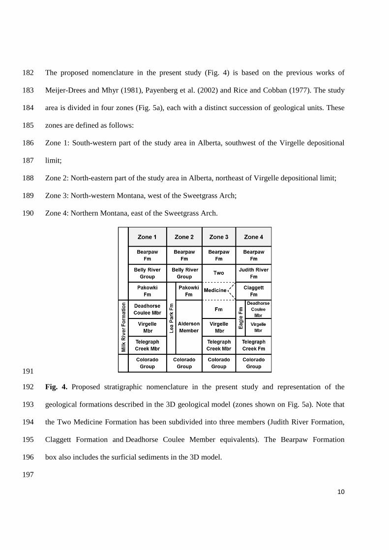
years after Russell’s (1970) attempt at correlating between the Milk River and Eagle Formations, 172
Payenberg (2002b) and Payenberg et al. (2002) reevaluated the lithostratigraphic and 173
chronostratigraphic relationships of Alberta and Montana Upper Cretaceous rocks. They used 174
recent advances in geochronology, magnetostratigraphy, and a paleontological database. The 175
work of Payenberg et al. (2002) provided a clearer litho- and chrono-stratigraphic framework of 176
the study area; it particularly showed that the Telegraph Creek, Virgelle, and Deadhorse Coulee 177
Members are continuous and correlative across the international border (Payenberg 2002a), and 178
also introduced the Alderson Member of the Lea Park Formation in the southern Alberta 179
nomenclature (Fig. 3). 180
181
10
The proposed nomenclature in the present study (Fig. 4) is based on the previous works of 182
Meijer-Drees and Mhyr (1981), Payenberg et al. (2002) and Rice and Cobban (1977). The study 183
area is divided in four zones (Fig. 5a), each with a distinct succession of geological units. These 184
zones are defined as follows: 185
Zone 1: South-western part of the study area in Alberta, southwest of the Virgelle depositional 186
limit; 187
Zone 2: North-eastern part of the study area in Alberta, northeast of Virgelle depositional limit; 188
Zone 3: North-western Montana, west of the Sweetgrass Arch; 189
Zone 4: Northern Montana, east of the Sweetgrass Arch. 190
191
Fig. 4. Proposed stratigraphic nomenclature in the present study and representation of the 192
geological formations described in the 3D geological model (zones shown on Fig. 5a). Note that 193
the Two Medicine Formation has been subdivided into three members (Judith River Formation, 194
Claggett Formation and Deadhorse Coulee Member equivalents). The Bearpaw Formation 195
box also includes the surficial sediments in the 3D model. 196
197

11
198
199
Fig. 5. a) Bedrock geological map of the study area (Adapted from Okulitch et al. 1996). b) 200
Cross-section (indicated by “S-N” in Fig. 5a) showing the unconformity surface separating the 201
Alderson Member from the three other members of the Milk River Formation. The encasing units 202
are not represented on this cross section (Adapted from O’Connell 2014). 203
204
205

12
Geological and Hydrostratigraphic Settings 206
207
The geology of the study area can be described as a succession of marine and continental 208
sediments that were deposited as the Upper Cretaceous Interior Sea level fluctuated (Russell 209
1970). The Upper Cretaceous strata are briefly described below and represented on the bedrock 210
geological map in Fig. 5a. Their hydrostratigraphic role is indicated in Fig. 6 and briefly 211
described in the present section. 212
213
Fig. 6. Stratigraphy and hydrostratigraphy of the main geological units of the study area. 214
215
216
Colorado Group 217
The Colorado Group (middle Albian to Santonian) underlies the entire study area (Fig. 4). It was 218
deposited during marine conditions in a moderate-depth sea environment. The Colorado Group 219
consists mainly of dark grey to black bentonitic marine shale. It ranges in thickness from 500 to 220

13
600 m in southern Alberta and from 450 to 500 m in north central Montana (Hendry et al. 1991; 221
Cobban et al. 1976). The upper boundary of the Colorado Group is commonly taken at the First 222
White Speckled Shales (Meyboom 1960). The Colorado Group is not exposed in southern 223
Alberta (Dyer and Williams 1930) but it outcrops widely over 5 counties in northern Montana, 224
from the Sweetgrass Hills to Great Falls (Cobban et al. 1976). It constitutes a regional aquitard in 225
the study area (Fig. 6) with a hydraulic conductivity ranging from 10-14 to 10-10 m/s (Hendry and 226
Schwartz 1988). The Colorado Group is overlain by the Milk River Formation and thus the 227
interface between these units constitutes the datum plane of the present regional study. 228
229
Milk River/Eagle Formation 230
The Milk River Formation (Eagle Sandstone in Montana) is a regressive clastic wedge deposited 231
during the Late Cretaceous (Rice 1980; Payenberg et al. 2001). The Milk River Formation has 232
been traditionally subdivided into three members: the basal Telegraph Creek Member, the middle 233
Virgelle Member and the upper Deadhorse Coulee Member. 234
The Milk River Formation is 150 m thick in the southwest corner of the Canadian part of the 235
study area and thins towards the northeast (O’Connell 2014). It subcrops in an area of 14 236
townships in southern Alberta near the border, in rings around the Sweetgrass Hills and along 237
both sides of the Sweetgrass Arch. According to Russell (1970): “There is little difference 238
between the western and eastern developments.” The Milk River Formation dips gently to the 239
north, east and west, from the subcrop areas following a radial or “fan-like” pattern (Meyboom 240
1960; Schwartz and Muehlenbachs 1979; Toth and Corbet 1986). The Milk River Formation is 241
confined below and above by the low-permeability shales of the Colorado Group and 242
Pakowki/Claggett Formations, respectively. 243
244

14
The Milk River Aquifer is within the Milk River Formation. The middle Virgelle Member is the 245
most important aquifer within the formation. The Milk River Aquifer is a confined and inclined 246
aquifer, which locally shows flowing artesian conditions. About 200 flowing artesian wells were 247
inventoried in the 1960s in southern Alberta (Meyboom, 1960). In Montana, flowing artesian 248
water occurs in much of the area of Cut Bank, Montana due to the westward dip of the formation 249
(Zimmerman 1967). Tuck (1993) also highlighted some flowing artesian wells in the Sweetgrass 250
Hills area. However, many wells have lost their artesian flow because of the intensive use of this 251
resource. Nowadays, the flowing artesian areas are located in the vicinity of Pakowki Lake and 252
north of the study area, which is still consistent with the flowing artesian limit drawn by Dowling 253
(1917) (Fig. 5a). 254
255
Meyboom (1960) showed that the recharge areas of the aquifer were located mainly in the 256
concentric outcrops around the Sweetgrass Hills and to a lesser extent at the subcrop area near the 257
international border. The main discharge areas are located at the pumping or flowing wells of the 258
study area, with small natural discharge (Meyboom 1960). 259
260
Groundwater flow in the Milk River Aquifer follows the regional dip of the Milk River/Eagle 261
Formation. In Alberta the general flow is semi-radial from the topographic highs of the 262
Sweetgrass Hills to the north, west and east (Hendry and Schwartz, 1988). In Montana, 263
groundwater flows from the Sweetgrass Hills to the east and south-east and also from the subcrop 264
areas west of the Sweetgrass arch to the west and south (Zimmerman 1967; Levings 1982). 265
Therefore, there are two transboundary flow paths in the study area: 1) from the Sweetgrass Hills 266
to the north, and 2) from north of the Cut Bank, Montana, area to the north (Zimmerman 1967; 267
Tuck 1993). 268

15
269
In southern Alberta, the Alderson Member of Lea Park Formation (Meijer-Drees and Mhyr 270
(1981) unconformably overlays the Milk River Formation in the north, northeast and east of the 271
study area (Fig. 5b). The Alderson Member is a lateral sandy shale equivalent to the Milk River 272
Formation and some authors (Hendry et al 1991) described the relation between the units as a 273
facies change. The Alderson Member has also been included in the Milk River Formation as a 274
fourth member (Payenberg et al. 2002; O’Connell 2014). However, it is much younger than the 275
other three members, is separated from them by a regional unconformity surface and is not 276
present in Montana (Payenberg et al. 2003; O’Connell 2014). In the framework of the present 277
study, the decision was made to include the Alderson Member as a member of the Lea Park 278
Formation as also done by other authors (e.g. Meijer-Drees and Mhyr 1981). The Alderson 279
Member is gas-bearing; it contains the Milk River gas field (or Medicine Hat gas field, Fig. 2), a 280
natural limit of the 3D geological model. Another natural limit is imposed by the Tiger Ridge gas 281
field in Montana, hosted by the Eagle Sandstone in the Bears Paw Mountains area (Fig. 2) 282
(Gautier and Rice 1982), and constitutes another natural boundary for the present 3D geological 283
model. 284
285
Telegraph Creek Member/Formation 286
The Telegraph Creek Member is a transitional unit between the shale of the Colorado Group and 287
the massive sandstone of the Virgelle Member of the Milk River Formation. It is interpreted as 288
deposits of an offshore to shore-face transition (Payenberg 2002a). The Telegraph Creek Member 289
consists of thinly interbedded sandy shale, siltstone and fine-grained shaly sandstone. The 290
Telegraph Creek is 36 to 52 m thick in the Cut Bank, Montana, area where it has formation status 291
(Cobban 1950; Payenberg et al. 2001) and it is 30 to 52 m thick near the Sweetgrass Hills 292

16
(Zimmerman 1967; Tuck 1993). The Telegraph Creek transition zone was originally included in 293
the Virgelle Sandstone in north-central and northwestern Montana by Stebinger (1915, 1917a). 294
295
Virgelle Member 296
The Virgelle Member gradationally overlies the Telegraph Creek Member (Meijer-Drees and 297
Mhyr 1981). It consists of grey to buff, thick bedded, fine to medium grained sandstone with 298
thinly bedded siltstone (Tuck 1993). The Virgelle Member was deposited during a regression 299
sequence and is interpreted as a shore-face to foreshore sandstone (Rice 1980). It is up to 69 m 300
thick in southern Alberta and varies from 15 to 60 m thick on the west side of the Sweetgrass 301
Arch (Lorenz 1981; O’Connell 2014). The Virgelle Member is not present in southwestern 302
Saskatchewan or central Alberta because it is truncated by the regional unconformity surface 303
separating the Milk River Formation and the Alderson Member. The Virgelle outcrops along the 304
Milk River in southern Alberta over approximately 25 km in Township 1 and 2, Ranges 12 to 15 305
(Meyboom 1960). It also outcrops on both sides of the Sweetgrass Arch, in continuous and 306
narrow belts (Fig. 5a). 307
308
The Virgelle Member massive sandstone is the most important aquifer part of the Milk River 309
Formation and therefore constitutes the Milk River Aquifer. The hydraulic conductivity of the 310
Virgelle sandstone in southern Alberta ranges from 10-8 to 10-6 m/s (Persram 1992 unpublished, 311
cited by AGRA 1998). South-east of the town of Milk River, the hydraulic conductivity of the 312
Virgelle is 1.8x10⁻⁷ m/s (Robertson 1988). The limits of the Milk River Aquifer are shown on 313
Fig. 2. They correspond to the area in which the Virgelle Member exists and is exploited. 314
However the 3D geological model extends farther west, to longitude -113°, where the Virgelle 315
Member continues in the subsurface but is too deep (> 400 m) to be used for groundwater supply 316
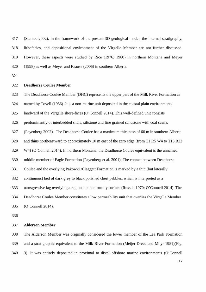
17
(Stantec 2002). In the framework of the present 3D geological model, the internal stratigraphy, 317
lithofacies, and depositional environment of the Virgelle Member are not further discussed. 318
However, these aspects were studied by Rice (1976; 1980) in northern Montana and Meyer 319
(1998) as well as Meyer and Krause (2006) in southern Alberta. 320
321
Deadhorse Coulee Member 322
The Deadhorse Coulee Member (DHC) represents the upper part of the Milk River Formation as 323
named by Tovell (1956). It is a non-marine unit deposited in the coastal plain environments 324
landward of the Virgelle shore-faces (O’Connell 2014). This well-defined unit consists 325
predominantly of interbedded shale, siltstone and fine grained sandstone with coal seams 326
(Payenberg 2002). The Deadhorse Coulee has a maximum thickness of 60 m in southern Alberta 327
and thins northeastward to approximately 10 m east of the zero edge (from T1 R5 W4 to T13 R22 328
W4) (O’Connell 2014). In northern Montana, the Deadhorse Coulee equivalent is the unnamed 329
middle member of Eagle Formation (Payenberg et al. 2001). The contact between Deadhorse 330
Coulee and the overlying Pakowki /Claggett Formation is marked by a thin (but laterally 331
continuous) bed of dark grey to black polished chert pebbles, which is interpreted as a 332
transgressive lag overlying a regional unconformity surface (Russell 1970; O’Connell 2014). The 333
Deadhorse Coulee Member constitutes a low permeability unit that overlies the Virgelle Member 334
(O’Connell 2014). 335
336
Alderson Member 337
The Alderson Member was originally considered the lower member of the Lea Park Formation 338
and a stratigraphic equivalent to the Milk River Formation (Meijer-Drees and Mhyr 1981)(Fig. 339
3). It was entirely deposited in proximal to distal offshore marine environments (O’Connell 340

18
2014). In southern Alberta, the Alderson Member is present just northeast of the depositional 341
limit of the Virgelle sandstone (Meijer-Drees and Mhyr 1981). The lithology of the Alderson 342
Member consists of interbedded very fine-grained sand, silt and mud (O’Connell 2014). The sand 343
content increases in the upper part (Meijer-Drees and Mhyr 1981). O’Connell (2014) includes the 344
Alderson Member as the youngest member of the Milk River Formation which is 100 m thick in 345
the northeast corner of the study area. The Alderson Member is younger than the Telegraph 346
Creek, Virgelle and Deadhorse Coulee Members of the Milk River Formation and is separated 347
from them by a regional unconformity representing a large time-gap (O’Connell 2014; Payenberg 348
2003). It therefore physically overlies and overlaps the erosional edges of the other three 349
members. The Alderson Member is about 85 m thick in southeastern Alberta (Meijer-Drees and 350
Mhyr 1981). 351
352
The Alderson Member hosts the Medicine Hat gas field (Hamblin and Lee 1997; Fig. 2). 353
However, the upper part of the Alderson Member contains two distinct large sand bodies which 354
form a regional aquifer in southern Alberta. This unit is named the Upper Alderson Sands by 355
O’Connell (2014). It covers an area of 74 townships and has a NW-SE trend (Fig. 2). The Upper 356
Alderson Sands forms small lobate sand bodies. According to O’Connell (2014): “The Virgelle 357
and Upper Alderson aquifers are separated from each other by muddy sediments of the Alderson 358
and Deadhorse Coulee members, but they are locally in contact at the Virgelle erosional edge and 359
water flow between the two aquifers is likely.” 360
361
Pakowki Formation/ Claggett Shale 362
The Milk River Formation is overlain by a thick unit of marine shales, the Pakowki Formation 363
(Claggett Shale equivalent in Montana). The Pakowki and Claggett Formations consist of thinly 364

19
bedded, black marine shales, with few sandstone beds (Tovell 1956 cited by Payenberg et al. 365
2003). The Pakowki Formation is 98 m thick at Bow Island, 65 m at Lethbridge, Alberta, and up 366
to 130 m in the Sweetgrass Hills area (Williams and Dyer 1930; Tuck 1993). A thin horizon of 367
chert pebbles is present at the base of the unit. The formation was deposited during an extensive 368
Late Cretaceous transgression episode; however the sea invasion did not reach the western part of 369
the Sweetgrass Arch (Stebinger 1917b; Williams and Dyer 1930). Therefore, the tongue of 370
marine shale progressively thins to zero westward. Where the Claggett/Pakowki Formations 371
pinch out, the Milk River Formation is directly overlain by the Judith River Formation/Belly 372
River Group. The top of the Pakowki Formation is equivalent to the top of the Lea Park 373
Formation in central Alberta (Williams and Dyer 1930; Meijer-Drees and Mhyr 1981; Dawson et 374
al 1994). The Pakowki/Claggett Formation effectively constitutes a regional aquitard (Fig. 6); the 375
hydraulic conductivity of the Pakowki/Claggett Formation is in the order of 10-11 m/s (Toth and 376
Corbet 1986; Anna 2011). 377
378
Two Medicine Formation 379
The non-marine Two Medicine Formation of Late Cretaceous age outcrops in northwestern 380
Montana. This unit consists of mudstones and sandstones and is about 600 m thick (Lorenz 381
1981). West of the Sweetgrass Arch, the Two Medicine Formation includes the equivalent upper 382
part of Eagle Formation (i.e. Deadhorse Coulee Member equivalent), the poorly recognizable 383
Claggett Shale and the Judith River Formation (Pierce and Hunt 1937; Zimmerman 1967; Gill 384
and Cobban 1973; Fig. 4). The Two Medicine Formation overlies the well-defined Virgelle 385
Member. It is 152 m thick in the Cut Bank, Montana, area (Zimmerman 1967). 386
387
Belly River/Judith River 388

20
The Belly River Group (or equivalent Judith River Formation in Montana) outcrops in a large 389
part of the study area (Fig. 5a). It represents the sequence of continental beds above the Pakowki 390
Formation and below the Bearpaw Formation. The Belly River includes the Dinosaur Park 391
Formation (upper part), the Oldman Formation (middle part) and Foremost Formation (lower 392
part) (Eberth and Hamblin 1993; Hamblin 1997) . However, the upper part is only present in a 393
limited part of the study area, covering of about 12 townships, near the Saskatchewan border 394
(Hamblin 1997). Fig. 5a is adapted from the geological map from Okulitch (1996) in which the 395
Dinosaur Park Formation is not represented. 396
397
The dark shale, sandstone and coal seams of the Foremost Formation are overlain by massive 398
yellow and grey sandstone of the Oldman Formation and thick sandstones and siltstones of the 399
Dinosaur Park Formation. The Belly River Group/Judith River Formation is 320 m thick at 400
Lethbridge, and is less than 182 m in northern Montana (Williams and Dyer 1930; Pierce and 401
Hunt 1937). The Belly River Group/Judith River Formation constitutes an aquifer with a 402
hydraulic conductivity ranging from 9x10⁻⁸ m/s to 8.8x10⁻⁷ m/s (Anna 2011). 403
404
Bearpaw Formation 405
The Bearpaw Formation overlies the Belly River Group/Judith River Formation (or the Two 406
Medicine Formation, west of the Sweetgrass Arch in Montana) and is made up of dark grey shale 407
(Russell 1970). These marine strata were deposited during a subsequent Late Cretaceous 408
transgression episode and are lithologically similar to the Pakowki Formation. In the western part 409
of the study area, the Bearpaw Formation outcrops along a narrow north-south band, and around 410
the Cypress Hills in south-eastern Alberta. The Bearpaw Formation is about 70 m thick in the 411
north-western part of the study area and constitutes a regional aquitard (Tokarsky 1974) (Fig. 6). 412

21
413
Available data and Methods 414
415
Data collection 416
Geological data from five sources were gathered. In Alberta, the first source of geological data 417
was from O’Connell (2014). Of the 2170 total borehole data, only the non-deviated wells were 418
selected to develop the 3D geological model (2070 borehole data). These data from non-deviated 419
wells contain the depth of the tops of the Alderson Member and the geological formations 420
included in the Milk River Formation: Deadhorse Coulee Member, Virgelle Member and 421
Telegraph Creek Member. The extent of the data is from 49° to 50.3° north latitude and from 422
longitude -110° to -113°. Amongst the data provided by O’Connell (2014), there is an area of 423
about 14 townships close to the border with no subsurface data for the Milk River Formation. 424
This area is the structural crest of the Sweetgrass Arch, in which the Milk River Formation is too 425
shallow to be covered by geophysical logs from hydrocarbon exploration boreholes. 426
427
The geological data of the units above the Milk River Formation were obtained from the Alberta 428
Geological Survey/Alberta Energy Regulator. The elevations of the tops of Lea Park Formation 429
(Milk River and Pakowki Formations equivalents) (unpublished data), Belly River Group 430
(Glombick 2010) and the bedrock topography (Atkinson and Lyster 2010) in southern Alberta 431
were added to the model. 432
433
In Montana, three sources of geological data were used: Feltis et al. (1981), described the 434
elevation of the tops of each geological formation in north central Montana, from Jurassic to 435
Quaternary. The geological formations in the Colorado Group to the Judith River Formation were 436

22
selected. The 190 resulting wells range from 48.2° to 49° north latitude and from longitude -437
109.6° to -112.5°. 438
439
The second source of geological information consists of well logs of the area, provided by the 440
Montana Geological Society (Montana Geological Society 2013). 103 scanned logs (mostly from 441
the 1950’s) located in Glacier, Toole, Liberty and Hill Counties were selected. They were 442
digitized and converted into elevation format to be integrated to the data set. These logs contain 443
the description of all the members that compose the Eagle Sandstone. 444
445
About 10 control wells with altitude of the top of Judith River Aquifer in northern Montana were 446
retrieved from a map produced by Noble et al. (1982). This map was scanned, georeferenced and 447
converted from feet into meters. 448
449
The top of the geological model is ground level, represented by a Digital Elevation Model (DEM) 450
of the study area. The DEM in Alberta is from the National Topographic Data Base (NTDB) and 451
the DEM of northern Montana is from USGS Earth Explorer. They are both at 1:50 000 scale (or 452
1 arc second). 453
454
The last source of data used in this study consisted of hydrogeological cross sections of the study 455
area from Borneuf (1974), Tokarsky (1974) and a transboundary map of the bedrock geology 456
from Okulitch et al. (1996). 457
458
These various geological data required several steps of conversion and transformation in order to 459
use them consistently in the building of the 3D geological model. 460

23
461
Method: Data processing and unification of the geological data 462
463
The geological data collected for this regional and transboundary study presented various formats 464
and several spatial and stratigraphic references. Data processing was needed to obtain a 465
consistent file containing the coordinates of a well and the associated elevations of each 466
geological formation. 467
468
The main steps of data processing were: the conversion from feet to meters and from spatial 469
reference NAD 27 to NAD 83, the transition from Township/Range system to latitude/longitude 470
coordinates and the transition from depth to elevation data (the reference is the mean sea level). 471
Additionally, the two available DEM files were merged to obtain a unique DEM covering the 472
study area. 473
474
The various sets of geological data on both sides of the border are now homogeneous (same 475
format, same spatial reference and same units). The next stage was to unify these data, since the 476
main goal of the 3D geological model is to represent the geology of the study area in a unified 477
way. Thus the geological data corresponding to equivalent layers in Alberta and Montana needed 478
to be merged. In particular, specific work on the equivalent members of the Milk River 479
Formation was needed to represent the Milk River Aquifer (i.e. Virgelle Member) in its entirety. 480
481
The collected data did not always present the same degree of information everywhere in the study 482
area. In order to assemble the data sets for each geological unit, some working hypotheses had to 483
be made following the 4 zones of the study area (Fig. 5a and Fig. 6). 484

24
485
O’Connell (2014) described every member of the Milk River Formation in Alberta (i.e. 486
Telegraph Creek, Virgelle and Deadhorse Coulee Members in zone 1 and the Alderson Member 487
in zone 2). Feltis et al. (1981) only represented the “Eagle Sandstone” which is the Milk River 488
Formation equivalent in northern Montana (zones 3 and 4). The constituting members of the 489
Eagle Sandstone are not described individually. Considering these two sources of data, the degree 490
of geological information on the Milk River Formation is higher in Alberta than in Montana. Yet, 491
we want to represent the 3 members of the Milk River Formation in the entire study area. 492
Consequently, the “Eagle Sandstone” layer from Feltis et al. (1981) was subdivided in 3 parts, 493
using the detailed logs from the Montana Geological Society (2013). In zone 3, the constitutive 494
members of the Two Medicine Formation were also described individually on the basis of the 495
detailed logs from the Montana Geological Society (2013). 496
497
Some of the wells from Feltis et al. (1981) were also part of the set of scanned logs from the 498
Montana Geological Society (2013). The comparison of these wells clearly showed that what 499
Feltis et al. (1981) called “Eagle Sandstone” actually included Telegraph Creek and Virgelle 500
Members west of the Sweetgrass Arch (zone 3). East of the Sweetgrass Arch (zone 4), the 501
comparison of the logs shows that an upper part (30 to 35 m thick) overlying the Virgelle 502
Member was also included in the “Eagle Sandstone” layer. This upper part would equate to the 503
“middle member” of Eagle, as defined by Payenberg et al. (2002), i.e. the Deadhorse Coulee 504
member equivalent in Alberta. 505
506
Based on these observations, it was assumed that east of the Sweetgrass Arch (zone 4), the top of 507
the Eagle Sandstone described by Feltis et al. (1981) corresponds to the top of the Deadhorse 508

25
Coulee Member whereas, west of the Sweetgrass Arch (zone 3), it corresponds to the top of the 509
Virgelle Member. 510
511
West of the Sweetgrass Arch, the upper part of Eagle is included within the Two Medicine 512
Formation and is not described. Therefore the question of how much of the lower part of the Two 513
Medicine Formation is actually equivalent to the Deadhorse Coulee Member was raised. 514
Reexamination of detailed boreholes from the Montana Geological Society (2013) west of the 515
Sweetgrass Arch allowed the identification of the transgressive chert pebble lag surface, which 516
represents the top of the Deadhorse Coulee. Too few descriptions delineated the chert pebbles 517
marker bed, so eventually it was decided to designate the lower 75 m of the Two Medicine 518
Formation as the Deadhorse Coulee equivalent. This value was based on the Lexicon definition 519
of the Two Medicine Formation (WEBLEX Canada 2013), which mentions coarse sandstone 520
beds in the lower 75 m interpreted to represent the fluvial channel sandstones of the Deadhorse 521
Coulee. Rice and Cobban (1977) supported this value, citing Cobban (1955): “the sandstone is 522
mainly in the basal 76 m, which is more or less equivalent to the middle and upper members of 523
the Eagle Sandstone”. A dummy data point set representing the top of the Deadhorse Coulee 524
west of the Sweetgrass arch was therefore added. Close to the international border, the thickness 525
of the Deadhorse Coulee Member was reduced at 60 m to be consistent with the data of 526
O’Connell (2014) in southern Alberta. 527
528
The geological layers overlying the Eagle Sandstone in Montana (Claggett Shale and Judith 529
River Formation) are only described east of the Sweetgrass Arch by Feltis et al. (1981) and the 530
Montana Geological Society (2013). West of the Sweetgrass Arch, both of these geological layers 531
are included in the Two Medicine Formation, which is not represented in the report of Feltis et al. 532

26
(1981), but is well described within the logs from the Montana Geological Society (2013). The 533
Two Medicine Formation is equivalent to the upper part of Eagle, Claggett Shale and Judith 534
River Formation (Zimmerman 1967). Thus, the top of the Two Medicine Formation was 535
identified as the top of the Judith River Formation in zone 3. 536
537
The top of the Pakowki Formation was assimilated into the top of Lea Park Formation in Alberta 538
(Williams and Dyer 1930; Meijer-Drees and Mhyr 1981; Dawson et al 1994; Fig. 4). In northern 539
Montana, the Claggett Shale is well described within the Montana Geological Society (2013) 540
well logs and some of the wells of Feltis et al. (1981). However, there are no data describing the 541
Claggett Shale west of Sweetgrass Arch since the marine invasion during which the 542
Claggett/Pakowki was deposited did not extend far beyond the Arch. The Claggett Shale wedges 543
out west of the Sweetgrass Arch, and where it pinches out, the Judith River(Belly River) strata 544
rest on the Deadhorse Coulee Member equivalent. 545
546
It is assumed that the top of the Belly River Group in southern Alberta (i.e. top of Oldman 547
Formation or Dinosaur Park Formation, where present) is the stratigraphic equivalent to the top 548
of the Judith River Formation in Montana (Russell 1970). The constitutive layers of the Belly 549
River in Alberta are not represented in the model since the contact between the Oldman and 550
Foremost Formations is difficult to identify (Williams and Dyer 1930). 551
552
In Alberta, the top of the Colorado Group was considered to be the bottom of the Telegraph 553
Creek Formation in zone 1, and the bottom of the Alderson Member in zone 2. 554
555

27
As mentioned previously, because of the lack of well logs in the southern Alberta outcrop area, 556
the data in O’Connell (2014) was supplemented by creating a file describing the bedrock 557
topography. The bedrock topography file was built by subtracting the thickness of surficial 558
sediments from the topography of the study area; it was then assumed that the top of the bedrock 559
corresponds to the top of the Deadhorse Coulee Formation where Deadhorse Coulee outcrops. 560
The same assumption was made for the Pakowki and Belly River outcrop areas, following the 561
geological map of Okulitch et al. (1996). Some manual editing was required to represent these 562
outcrop areas with more details. For that purpose, the bedrock geological map (Okulitch et al. 563
1996) was superimposed on the model as a reference. 564
565
The regional unconformity between the Milk River Formation and the Alderson Member is also 566
represented in the 3D model. In the north, northeast and east of the study area, the Telegraph 567
Creek, Virgelle and Deadhorse Coulee members are progressively overlapped by the Alderson 568
Member. An overlapping area is represented, based on the isopach maps of O’Connell (2014). 569
The two sand bodies which make up the upper part of the Alderson Member (Upper Alderson 570
Sands, Fig. 2) are not represented separately but they are included in the Alderson Member. 571
572
Finally, it was decided that the Bearpaw Formation and the surficial sediments would be grouped 573
in one layer in the geological model, between the top of the Belly River/Judith River and the 574
ground level. With the geological data on both sides of the border harmonized and the 575
stratigraphy unified, the 3D geological model could be built. 576
577
Construction of the 3D unified geological model 578
579

28
The software chosen to build the 3D geological model is Leapfrog Hydro® (Leapfrog Hydro 580
2013). The approach to build the 3D geological model was to use location data (x, y, z) 581
representing the top of the geological units. Contact surfaces were first created from these data. 582
Then, volumes were obtained from the surfaces for which a chronology had been first 583
determined. Leapfrog Hydro is a recent software and it was chosen mostly for its interoperability 584
with FEFLOW (Finite Element subsurface Flow) (Diersch 2014). The 3D geological unified 585
model will form the basis of a 3D numerical hydrogeological model of the Milk River Aquifer 586
using FEFLOW. 587
588
An initial geological model was built as a reference and for the purpose of comparison before and 589
after unification of the geological datasets from both sides of the international boundary. The 590
reference model contains the data from O’Connell (2014) and Feltis et al. (1981) before the 591
harmonization of the geological units. A south-north transboundary cross-section A-A’ from this 592
reference model is shown in Fig. 7. This section shows that the level of information was higher in 593
southern Alberta (where Telegraph Creek, Virgelle and Deadhorse Coulee Members were 594
represented) than in northern Montana (where the Eagle Sandstone was solely represented). The 595
two datasets are simply placed alongside in this reference model, so the geological layers are 596
obviously abruptly separated at the international border. The same cross-section A-A’ will be 597
shown as unified in the Results section below (Fig. 9b). 598
599

29
600
Fig. 7. Transboundary cross-section (south-north) before the unification of the Milk River/Eagle 601
Formation. The geological units above the Milk River/Eagle Formation are not represented in this 602
section. The location of the cross-section is shown in Fig. 9a. 603
604
In a subsequent geological model, the integration of detailed logs from Montana Geological 605
Society (2013) and the formulation of working hypothesis on the equivalent layers (described 606
above) allowed the building of the unified 3D geological model of the study area and the 607
separation of the Eagle Formation into three members. The datasets in the 4 zones of the study 608
area (Fig. 5a; Fig. 6) were finally merged to represent each geological unit. 609
610
Furthermore, the model was adjusted with the help of cross-sections existing for the study area. 611
About 15 cross-sections (Borneuf 1974; Tokarsky 1974) in Alberta were georeferenced and 612

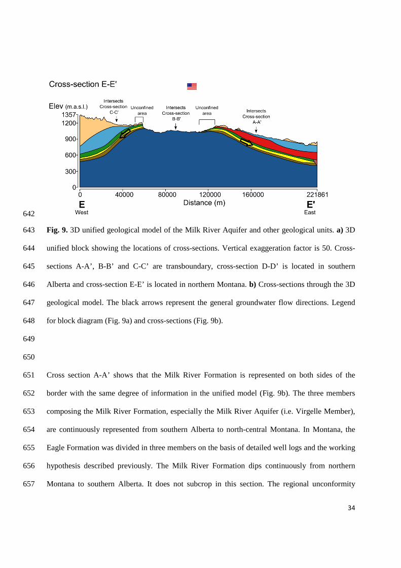
30
included in the geological model. The cross sections serve as a guide and allow adjustments of 613
the geological surfaces by manual editing within Leapfrog Hydro® (Fig. 8) 614
615
The construction of a sloping surface was needed to represent the regional unconformity between 616
the Milk River Formation and the Alderson Member. This surface was built by selecting points 617
from the Alderson Member dataset, which make up a plateau overlapping Virgelle and 618
Deadhorse Coulee Member. 619
620
Fig. 8. Examples of geo-referenced cross-sections included in the 3D geological model. 621
622
Results 623
624
The unified 3D geological model covers 50 000 km2. The geological units represented in the 625
model are (in ascending order): Colorado Group, Telegraph Creek Member, Virgelle Member, 626
Deadhorse Coulee Member, Alderson Member, Claggett Shale/Pakowki Formation, Belly River 627
Group/Judith River Formation, Bearpaw Formation and surficial sediments (undivided) (Fig. 9). 628

31
The locations of sections through the geological model are shown on Fig. 9a and these sections 629
are illustrated in Fig. 9b. The general groundwater flow direction is indicated on the cross-630
sections, based on previous work (Meyboom 1960; Zimmerman 1967; Levings 1982; Tuck 1993; 631
AGRA Earth and Environmental Limited 1998). The area in which the Alderson Member is no 632
longer water-bearing but gas-bearing is indicated on the cross-sections A-A’, B-B’ and D-D’. The 633
bedrock geological map is superimposed on the model (Fig. 9a). Note that the Two Medicine 634
Formation is shown on the geological map; however the 3D model details all the constitutive 635
members of this formation, especially as shown on cross-section E-E’. 636
637

32
638
639

33
640
641
34
642
Fig. 9. 3D unified geological model of the Milk River Aquifer and other geological units. a) 3D 643
unified block showing the locations of cross-sections. Vertical exaggeration factor is 50. Cross-644
sections A-A’, B-B’ and C-C’ are transboundary, cross-section D-D’ is located in southern 645
Alberta and cross-section E-E’ is located in northern Montana. b) Cross-sections through the 3D 646
geological model. The black arrows represent the general groundwater flow directions. Legend 647
for block diagram (Fig. 9a) and cross-sections (Fig. 9b). 648
649
650
Cross section A-A’ shows that the Milk River Formation is represented on both sides of the 651
border with the same degree of information in the unified model (Fig. 9b). The three members 652
composing the Milk River Formation, especially the Milk River Aquifer (i.e. Virgelle Member), 653
are continuously represented from southern Alberta to north-central Montana. In Montana, the 654
Eagle Formation was divided in three members on the basis of detailed well logs and the working 655
hypothesis described previously. The Milk River Formation dips continuously from northern 656
Montana to southern Alberta. It does not subcrop in this section. The regional unconformity 657

35
between the traditional 3 members of the Milk River Formation and the Alderson Member is 658
represented as an area of overlap. Groundwater flow is directed to the north, from northern 659
Montana to Alberta. The overlapping area of the Alderson Member corresponds to the Upper 660
Alderson Sands. This part is still water-bearing. However, farther north, the Alderson Member is 661
gas-bearing. 662
663
Cross-section B-B’ (Fig. 9b) shows a steeper slope of the Milk River Formation from the 664
international border to the north. The Colorado Group outcrops in northern Montana. A 665
subcrop/outcrop area of the Milk River Formation at the border indicates unconfined conditions 666
of the aquifer corresponding to a recharge area. 667
668
West of the Sweetgrass Arch, cross-section C-C’ (Fig. 9b) shows that the Claggett(Pakowki) 669
Formation pinches out in northwestern Montana. In Alberta, the Milk River Formation is overlain 670
by the Pakowki (Claggett) Formation and the thick Belly River Group (Judith River Formation), 671
whereas in Montana the Judith River Formation directly overlies the Milk River Formation 672
equivalents. The Milk River Aquifer is confined and the general groundwater flow is from south 673
to north, except in the vicinity of Cut Bank (Fig. 5a) where it is directed to the south. 674
675
676
Cross-section D-D’ (Fig. 9b) is located in Alberta; it shows the gentle antiformal geometry of the 677
Milk River strata dipping eastward and westward as well as the overlap of the Alderson Member 678
to the east. The Milk River Formation is overlain by 20 to 160 m of Pakowki(Claggett) 679
Formation and 20 to 200 m of Belly River Group (Judith River Formation). Groundwater flows 680

36
to the north (perpendicular to the cross-section plan), as well as to the east and west following the 681
aquifer elevation. 682
683
Cross-section E-E’ (Fig. 9b) is located in northern Montana in the vicinity of the Sweetgrass 684
Arch axis. The large outcrop of the Colorado Group is represented. The Milk River Formation 685
equivalents dip to the east and to the west on both sides of the Sweetgrass Arch. The Claggett 686
(Pakowki) Formation is not present west of the Sweetgrass Arch, but it overlies the Eagle 687
Formation in the east. There are two subcrop areas of the Milk River Formation equivalents 688
which correspond to the east and west outcrop bands described above in the bedrock geological 689
map (Fig. 5a) and the Geological Section. Therefore, the Milk River Aquifer is under unconfined 690
conditions in these areas that represent recharge zones. Groundwater flow is directed to the south 691
(perpendicular to the cross-section plan), as well as west and east from the subcrop areas. 692
693
The illustration of the 3D unified geological model is complemented by several elevation and 694
isopach maps of some of the key geological units (Fig. 10).These maps are derived from the 3D 695
geological model which comes from the various sources previously described in the “Data 696
Collection” section. The elevation of the top of the Milk River Formation (including Telegraph 697
Creek, Virgelle, Deadhorse Coulee and Alderson Members) is shown in Fig. 10a. The Milk River 698
Formation dips to the north, east and west from the outcrop area near the international border 699
following a semi-radial pattern. This pattern is continuous through the international border as the 700
Milk River formation dips to the east, south-east and north from the Sweetgrass Hills and to the 701
west, in the area west of the Sweetgrass Arch. The top of the Milk River Formation reaches about 702
1100 m at the border and decreases to 500 m in the northern part of the study area, about 130 km 703
north of the border. Therefore, the average slope is around 4.7 m/km. In Montana, the dip of the 704

37
Milk River Formation equivalents is more pronounced; the top of the formation attains 1100 m 705
around the Sweetgrass Hills and drops to 550 m in the eastern part of the study area, the average 706
slope is therefore 9 m/km. West of the Sweetgrass Arch, the top of the Milk River Formation 707
equivalents drops from 1150 m to 600 m in less than 50 km, so the mean slope is around 13 708
m/km. The thickness of the Milk River Formation ranges from 0 to 140 m in Alberta and from 0 709
to 200 m in Montana. In the subcrop areas, the formation is 0 to 60 m thick. 710
711
The elevation of the Virgelle Member top is shown in Fig. 10b. As the middle member of the 712
Milk River Formation, it follows the same dipping configuration. The unit thickness ranges 713
between 0 to 60 m in the study area. The Virgelle Member thins towards the deposition limit, 714
which extends from the northwest corner of the study area to the east, near the international 715
border. The extent of the Alderson and Virgelle Members (Fig. 10c) are mutually exclusive 716
except for an overlapping area in the vicinity of the deposition limit of Virgelle where the 717
Alderson Member is 0 to 15 m thick. The Alderson Member thickens to the north and east and 718
reaches a thickness of 95 m in the northeast corner of the study area. 719
720
The Milk River Formation is confined by the overlying Pakowki/Claggett Formation which 721
follows the general semi-radial dip of the Milk River Formation (Fig. 10d). The elevation of the 722
top of the Pakowki/Claggett Formation is about 900 m north of the subcrop area of the Milk 723
River Formation. It reaches an elevation of 550 m approximately 120 km farther north. The 724
thickness of this unit ranges from 0 to 160 m; the unit thins from east to west. 725
The Claggett Shale is not present west of the Sweetgrass arch; it might not be present in the 726
south-west area close to the border in Alberta. Due to the lack of data in the area where Claggett 727
wedges out, the contours are approximate. 728

38
729

39
Fig. 10. Unified elevation contours of the top of several geological units (left) and isopach maps 730
(right). The elevation reference is the mean sea level and the thickness is in meters. These maps 731
are derived from the 3D geological model which comes from the various sources previously 732
described in the “Data Collection” section. a) Elevation and thickness of the Milk River 733
Formation (including Telegraph Creek, Virgelle, Deadhorse Coulee and Alderson Members). b) 734
Elevation and thickness of the Virgelle Member. c) Elevation and thickness of the Alderson 735
Member. d) Elevation and thickness of the Pakowki/Claggett Formation. 736
737
738
Discussion 739
740
Changes and confirmations in the geological context 741
The cross-sections (Fig. 9) and the elevation and isopach maps (Fig. 10) corroborate previous 742
studies of the Milk River Aquifer. In particular, the semi-radial pattern of the elevation of the 743
Milk River Formation top shown in Fig. 10a is in agreement with Meyboom (1960) and others in 744
southern Alberta. Besides, the unified 3D geological model completes this observation by 745
showing that the semi-radial pattern continues into northern Montana. 746
747
The 3D geological model represents the subcrop areas of the Milk River Formation near the 748
Sweetgrass Hills and near the international border, which are also traditionally well-documented. 749
However, the model also indicates two additional subcrop areas on both sides of the Sweetgrass 750
Arch in Montana. 751
752

40
This study represents the Alderson Member distinctly from the other three members of the Milk 753
River Formation, separated by a regional unconformity. Previously, the interpreted gradual facies 754
change of the Milk River Formation was only conceptually represented but it was not included in 755
a 3D geological model. 756
757
Furthermore, the 3D unified geological model includes the area west of the Sweetgrass Arch in 758
Montana (zone 3). This area was little documented in previous Milk River Aquifer studies. Yet, 759
this is an important area since it hosts the southwestern part of the Milk River Aquifer. Thus, 760
consideration of this zone allows a complete geological representation of the aquifer. The 761
originality of the present work also lies in the representation of the three members of the Milk 762
River Formation continuously across the international border (especially the middle Virgelle 763
Member which is the Milk River Aquifer), as well as the overlying and underlying strata. The 3D 764
geological model thus represents the natural limits of the Milk River Aquifer, not influenced by 765
jurisdictional boundaries. 766
767
Hydrogeological implications of the geological model 768
The elevation contour maps and cross-sections provide a better appreciation of the confined 769
conditions of the aquifer. The Milk River Formation dips to the north from the outcrop areas in 770
the Sweetgrass Hills and near the border in southern Alberta (zones 1 and 2). It dips to the south 771
and east in zone 3 and to the south and west in zone 4. The Milk River Aquifer is therefore 772
confined throughout most of the study area by the overlying Pakowki/Claggett Formations. The 773
recharge areas of the Milk River aquifer have been traditionally identified as the outcrop areas 774
near the border in southern Alberta and around the Sweetgrass Hills in Montana. However, the 775

41
Milk River Formation and most importantly the Virgelle Member, subcrop also along both sides 776
of the Sweetgrass Arch in Montana (Fig. 4a; Fig. 9a), which could also represent recharge areas. 777
778
The Milk River Aquifer is limited to the north, north-east, and east by the erosional unconformity 779
surface which is overlapped by its lateral equivalent the Alderson Member. Since Alderson 780
Member is included in the Milk River Formation (O’Connell 2014; Payenberg et al. 2003) and its 781
upper part (Upper Alderson Sand) is water-bearing, it has been included in the delineation of the 782
Milk River Aquifer in Southern Alberta by Printz (2004). However, Printz (2004) did not 783
mention the presence of the Alderson Member, unconformably incised into the older members of 784
the Milk River Formation. O’Connell (2014) considered that the Milk River Aquifer consists of 785
two regional sand units within the Milk River Formation: the Virgelle Sand and the Upper 786
Alderson Sands. However, Alderson Member is much younger than the three other members of 787
the Milk River Formation (Payenberg et al. 2002). In addition, unlike the Virgelle Member which 788
is transboundary and continuous through the international border, the Alderson member is not 789
present in Montana where its chronostratigraphic equivalent is located south of the study area 790
(Payenberg et al. 2003). These differences lead us to consider the Alderson Member as distinct 791
from the other members of the Milk River Formation. Thus, the present study limits the Milk 792
River transboundary aquifer to the transboundary Virgelle Member only. 793
794
The Milk River Aquifer is limited by the Medicine Hat (Milk River) gas field hosted by the 795
Alderson Member, north, north-east and east of the study area in Alberta. The Tiger Ridge gas 796
field located near the city of Havre (near the Bears Paw Mountains in Montana) represents the 797
south-eastern boundary of the aquifer. In Alberta, the Alderson Member represented in the 3D 798
model, overlaps the lower members of the Milk River Formation. There is no equivalent 799

42
relationship for the Eagle Formation which hosts the Bearpaw gas field in Montana. For the 800
purpose of the 3D geological model, the Marias River is used as the southern limit of the Aquifer 801
in Montana. Although the Milk River/Eagle Formation extends farther south in Montana, the 802
Marias River physiographic limit has been chosen with respect to the future hydrogeological 803
model and considering the available data. The western limit of the aquifer corresponds to the 804
westernmost area in which water wells have been completed in the Virgelle Member. However, 805
the 3D geological model shows that Virgelle Member exists farther west around the longitude -806
113° (Fig. 2). No water well is completed in this unit beyond the proposed limit because the 807
aquifer is too deep (Stantec 2002). Thus, the western limit of the aquifer was based on the extent 808
of Virgelle Member water wells. 809
This work provides a comprehensive geological framework supporting the development of a 810
conceptual model of the Milk River Aquifer. However, other components of the conceptual 811
model still need to be assessed (groundwater-surface water interaction, discharge areas, 812
quantification of transboundary fluxes, geochemistry, etc). Further work will address these 813
components through the development of a unified hydrogeological numerical model of the 814
aquifer. 815
816
Model limitations 817
The amount of available data in Alberta is much higher than in Montana. In order to improve the 818
quality of the 3D geological model, collecting more well log descriptions within northern 819
Montana would be necessary. Regarding the overall resolution of the regional model, the density 820
of geological data is less than 1 datum per km2. According to the classification of geological 821
models of Culshaw (2005), the geological model would thus be of the “Overview” type. 822
823

43
Simplifications were made concerning the Pakowki/Claggett volume in zone 4. Previous studies 824
described that the transgressive strata did not reach the 112th meridian or wedges out in the 825
vicinity of Cut Bank (Stebinger 1917a; Russell 1970). The volume was not represented west of 826
the Sweetgrass Arch. A rough slimming of the volume was manually edited from the outcrop 827
area of Pakowki in southern Alberta in zone 1 towards the south in zone 3, just north of the 828
Virgelle outcrop. More geological data are needed in the northern part of zone 3 in order to 829
represent the Pakowki equivalent and its disappearance in a more realistic way. Another 830
simplification was made in considering that the interval between the top of the Belly River 831
Group/Judith River Formation and land surface included the Bearpaw Formation (when present) 832
and surficial sediments. 833
834
The effort for unification of the Milk River Formation across the international border implied 835
identifying its 3 constitutive members in zones 3 and 4 in Montana, where these members had not 836
previously been defined. This could be done more easily in zone 4 than in zone 3 thanks to the 837
correlation work of Payenberg et al. (2002). The Eagle Sandstone described by Feltis et al. (1981) 838
included the basal Telegraph Creek, Virgelle Member and an upper part, just below the Claggett 839
Shale, which was equated to the Deadhorse Coulee (or middle member of Eagle, following the 840
nomenclature of Payenberg et al. 2002). The upper member of Eagle described in Choteau and 841
Fergus Counties, Montana, does not exist in the study area, according to its depositional area map 842
(Payenberg et al. 2003). 843
844
In zone 3, the absence of the Claggett/Pakowki Formation makes the unification work more 845
complex. The Telegraph Creek and Virgelle Members were positively described in well logs. 846
However, the overlying layers were included in the Two Medicine Formation. Given the lack of 847

44
data in that zone, it was decided to consider the lower 75 m of the Two Medicine Formation as 848
the Deadhorse Coulee equivalent in zone 3, following the description of the Lexicon (WEBLEX 849
Canada 2013). However, isopach maps from O’Connell (2014) indicated that the thickness of the 850
Deadhorse Coulee was about 60 m at the border. The thickness of the dummy Deadhorse Coulee 851
in zone 3 was thus reduced to 60 m close to the border (about 10 km north of the border) to be 852
consistent and continuous with O’Connell’s data (2014). The default thickness of 75 m was 853
applied in the remaining area of the geological model. This default value is approximate and 854
might not reflect reality in all of zone 3. However this is considered as an acceptable hypothesis 855
in this regional geological framework study. 856
857
The integration of georeferenced cross-sections in the geological model was valuable. It allows 858
verification of how representative the collected geological data were, and the manual editing of 859
geological surfaces based on georeferenced cross-sections compensates for the lack of data 860
encountered in some places (Fig. 8). This technique was particularly useful for the 861
Claggett/Pakowki and Belly River/Judith River surfaces. Cross-sections also show that the 862
hypothesis of equating the tops of Belly River, Pakowki or Deadhorse Coulee to the bedrock 863
topography, where these formations outcropped, was valid. However, there is no cross-section 864
included in the model on the USA side. Cross-sections from the geological maps of the 865
Sweetgrass Hills and Cutbank 30′x60′ quadrangles (Lopez 2001; Berg 2002) did not show a 866
sufficient vertical exaggeration. Thus, the quality of these cross-sections in northern Montana did 867
not allow their use for the development of the 3D geological model. 868
869
The Upper Alderson Sands which form small lobate sand bodies was not represented in the 870
model, due to the limitation of the modeling software. However, this unit will be represented in 871
45
the future hydrogeological FEFLOW model of the aquifer, with distinct hydrogeological 872
properties from the Alderson Member. 873
874
Leapfrog Hydro® was chosen mostly for its interoperability with FEFLOW. When using data of 875
various formats in Leapfrog Hydro®, the geological model results in several geological models, 876
each with a specific data format, that are assembled to make up the whole model. Yet, when 877
exporting the model from Leapfrog Hydro® to FEFLOW, only one geological model can be 878
selected for transfer into FEFLOW. This implies the use of data of the same format (locations file 879
with X, Y, Z coordinates). 880
881
The area where the Alderson Member overlaps the lower members of the Milk River Formation 882
was difficult to represent with Leapfrog Hydro because many operations and manual editing were 883
necessary. Other software (such as Gocad) could have provided more flexibility for that 884
particular task. The geological model is dynamic; new data or editing of surfaces could be added 885
in an iterative model improvement process. 886
887
Conclusion and Perspectives 888
889
Geological data on both sides of the Canada/USA border were gathered and processed in order to 890
build a unified three-dimensional geological model of the Milk River Aquifer. 891
The main contributions of this paper are: 892
-Our work allowed the unification of the stratigraphic framework of the Milk River 893
Transboundary Aquifer on both sides of the Canada/USA border. 894

46
-There is a more rigorous delineation of the extent of the Milk River Transboundary Aquifer, and 895
a better description of its characteristics (thickness, geometry) following its natural boundaries 896
(not the jurisdictional boundaries). 897
-The 3D geological model provides a representation of the three members of the Milk River 898
Formation (especially the Virgelle Member (Milk River Aquifer) and encasing units continuously 899
through the border. 900
-The 3D geological model also provides a description of the geological boundaries of the Milk 901
River Aquifer, imposed by the regional structure, the regional unconformity in southern Alberta, 902
and the sealing effects of the adjacent gas fields. 903
-The 3D geological model also includes the representation of the gas-bearing Alderson Member 904
and the regional unconformity surface which separates it from the lower members of the Milk 905
River Formation. 906
-The implications of the geological model on the hydrogeological conditions of the aquifer have 907
been highlighted. The hydrostratigraphic role (aquifer or aquitard) of each geological unit has 908
been shown. 909
910
This 3D unified geological model is a major component of a unified conceptual hydrogeological 911
model of the Milk River Aquifer. It will form the basis for the future development of a numerical 912
model of the Milk River Aquifer. The next stage in this study will be to propose a unified 913
hydrogeological conceptual model of the Milk River aquifer, including boundary conditions, 914
groundwater flow systems, and groundwater quality. The final stage will be to transfer the 915
geological model into FEFLOW that will be used to develop a numerical groundwater flow 916
model. This transfer of the geological model will allow hydrogeological properties to be assigned 917
to each geological layer. 918

47
919
Acknowledgments 920
921
This work was funded by the Groundwater Geoscience Program of the Geological Survey of 922
Canada within MiRTAP (Milk River Transboundary Aquifer Project). Authors are thankful to the 923
USGS office in Helena (Montana, USA) for the digitization of the USGS Feltis et al. (1981) 924
report. We especially thank Joanna Thamke and the team of four who digitized and reviewed the 925
Feltis et al. report so skillfully. We thank Luke Buckley from the Montana Bureau of Mines and 926
Geology for converting the township/range location of the Feltis et al. report into 927
latitude/longitude coordinates. Thanks are due to Dan Palombi from the Groundwater Section 928
and the bedrock geologists of the Alberta Geological Survey (Alberta Energy Regulator) in 929
Edmonton for providing access to their geological data through a data-sharing agreement with the 930
Geological Survey of Canada. We also acknowledge Tony Hamblin (GSC-Calgary Division) for 931
his help and useful discussion. This is an Earth Sciences Sector contribution number 20130500. 932
933
References 934
935
AGRA Earth and Environmental Limited 1998. Evaluation of depletion of the Milk River 936
aquifer. AGRA Earth & Environmental, Edmonton. 937
938
Alberta Innovates Technology Future 2010. Milk River Aquifer Hydrogeology Report. Internal 939
Report for the Geological Survey of Canada, Quebec Division. 940
941

48
Anna, L.O. 2011. Effects of groundwater flow on the distribution of biogenic gas in parts of the 942
northern Great Plains of Canada and United States. USGS Scientific Investigations Report: 943
2010-5251, 24p. 944
945
Atkinson, N., and Lyster, S. 2010. Bedrock Topography of Alberta, Canada. Energy Resources 946
Conservation Board, ERCB/AGS Map, 550. 947
948
Berg, R.B. 2002. Geologic map of the Cut Bank 30’ x 60’ quadrangle. Montana Bureau of Mines 949
and Geology: Open-File Report 454, 10 p., 1 sheet. 950
951
Borneuf, D.M. 1974. Hydrogeological map Foremost, Alberta: NTS mapsheets 72E, Alberta 952
Research Council, Edmonton, Alberta. 953
954
Borneuf, D.M. 1976. Hydrogeology of the Foremost Area. Alberta, Alberta Research Council, 955
Edmonton, Alberta. 956
957
Cobban, W.A. 1950. Telegraph Creek Formation of Sweetgrass Arch, North-Central Montana: 958
GEOLOGICAL NOTES. AAPG Bulletin 34:1899–1900. 959
960
Cobban ,W.A. 1955. Cretaceous rocks of northwestern Montana, in Billings Geol. Soc. 961
Guidebook 6th Ann. Field Conf., Sweetgrass Arch-Disturbed Belt, Montana, p. 107-119. 962
963

49
Cobban, W.A., Erdmann, C.E., Lemke, R.W., and Maughan, E.K. 1976. Type sections and 964
stratigraphy of the Blackleaf and Marias River Formations (Cretaceous) of the Sweetgrass Arch, 965
Montana. USGS Professional Paper 974: 36–60. 966
967
Culshaw, M.G. 2005. From concept towards reality: developing the attributed 3D geological 968
model of the shallow subsurface. Quarterly Journal of Engineering Geology and 969
Hydrogeology 38:231–284. doi: 10.1144/1470-9236/04-072. 970
971
Diersch, H.-J.G. 2014. FEFLOW: finite element modeling of flow, mass and heat transport in 972
porous and fractured media. Springer, 996 p. 973
974
Dawson, F.M., Evans, C.G., Marsh, R., and Richardson, R. 1994. Uppermost cretaceous and 975
tertiary strata of the western Canada sedimentary basin; in Geological Atlas of the Western 976
Canada Sedimentary Basin, G.D. Mossop and I. Shetsen (comp.), Canadian Society of Petroleum 977
Geologists and Alberta Research Council. 978
979
Dowling, D.B. 1915. Water supply, southeastern Alberta. Summary Report 1915; Geological 980
Survey of Canada, Summary Report (1915), 1916; p. 102-110. 981
982
Dowling, D.B. 1917. Southern plains of Alberta. Geological Survey of Canada, “A” Series Map 983
187A, 1917; 1 sheet, doi:10.4095/106740. 984
985
Dyer, W.S. and Williams, M.Y. 1930. Geology of southern Alberta and southwestern 986
Saskatchewan. Memoir 163, Geological Survey of Canada. 987

50
988
Eberth, D.A., and Hamblin, A.P. 1993. Tectonic, stratigraphic, and sedimentologic significance 989
of a regional discontinuity in the upper Judith River Group (Belly River wedge) of southern 990
Alberta, Saskatchewan, and northern Montana. Can J Earth Sci 30:174–200. doi: 10.1139/e93-991
016. 992
993
Evans, C. S. 1931. Milk River area and the Red Coulee Oil Field, Alberta. Geological Survey of 994
Canada, Summary Report (1930), p. 1–30. 995
996
Feltis, R.D., Lewis, B.D., Frasure, R.L., Rioux, R.P., Jauhola, C.A., and Hotchkiss, W.R. 1981. 997
Selected geologic data from the Northern Great Plains area of Montana. USGS Open-File 998
Report 81-415. 999
1000
Gautier, D., and Rice, D. 1982. Conventional and Low-Permeability Reservoirs of Shallow Gas 1001
in the Northern Great Plains. Journal of Petroleum Technology. doi: 10.2118/9846-PA. 1002
1003
Gill, J.R., and Cobban, W.A. 1973. Stratigraphy and geologic history of the Montana group and 1004
equivalent rocks, Montana, Wyoming, and North and South Dakota. USGS Professional Paper 1005
776, 25p. 1006
1007
Glombick, P.M. 2010. Top of the Belly River Group in the Alberta Plains: Subsurface 1008
Stratigraphic Picks and Modelled Surface. Open file Report 2010-10. Energy Resources 1009
Conservation Board, ERCB/AGS. 1010
1011

51
Government of Alberta, Alberta water for life 2006. Water conservation and allocation guideline 1012
for oil field injection. 1013
1014
Hamblin, A.P. 1997. Regional Distribution and Dispersal of the Dinosaur Park Formation, Belly 1015
River Group, Surface and Subsurface of Southern Alberta. Bulletin of Canadian Petroleum 1016
Geology 45:377–399. 1017
1018
Hamblin, A.P., and Lee P.J. 1997. Uppermost Cretaceous, post-Colorado Group gas resources of 1019
the Western Canada Sedimentary Basin, Interior Plains. Geological Survey of Canada. Bulletin 1020
518. 1021
1022
Hendry, M.J., and Schwartz, F.W. 1988. An alternative view on the origin of chemical and 1023
isotopic patterns in groundwater from the Milk River Aquifer, Canada. Water Resour Res 1024
24:1747–1763. doi: 10.1029/WR024i010p01747. 1025
1026
Hendry J., Schwartz, F.W., and Robertson, C. 1991. Hydrogeology and hydrochemistry of the 1027
Milk River aquifer system, Alberta, Canada: a review. Applied Geochemistry 6:369–380. doi: 1028
10.1016/0883-2927(91)90037-P. 1029
1030
LEAPFROG Hydro® (2013) ARANZ Geo, http://www.leapfrog3d.com. 1031
1032
Levings, G.W. 1982. Potentiometric-surface map of water in the Eagle Sandstone and equivalent 1033
units in the Northern Great Plains area of Montana. USGS Open-File Report 82-565. 1034
1035

52
Lopez, D.A. 2001. Geologic map of the Sweet Grass Hills 30’ x 60’ quadrangle, north-central 1036
Montana, Montana Bureau of Mines and Geology Open-File Report 443, 4 p., 1 sheet, 1:100 000. 1037
1038
Lorenz, J.C. 1981. Sedimentary and Tectonic History of the Two Medicine Formation, Late 1039
Cretaceous (Campanian), Northwestern Montana. Princeton University. 1040
1041
Meijer-Drees, N.C., and Mhyr, D.W. 1981. The Upper Cretaceous Milk River and Lea Park 1042
Formations in Southeastern Alberta. Bulletin of Canadian Petroleum Geology 29:42–74. 1043
1044
Meyboom, P. 1960. Geology and groundwater resources of the Milk River sandstone in southern 1045
Alberta. Research Council of Alberta. 1046
1047
Meyer, R. 1998. Sedimentology, petrology and permeability characterization of the Upper 1048
Cretaceous Virgelle Member, Milk River Formation, Writing-on-Stone Provincial Park, Alberta, 1049
Canada. University of Calgary. 1050
1051
Meyer, R., and Krause, F.F. 2006. Permeability anisotropy and heterogeneity of a sandstone 1052
reservoir analogue: An estuarine to shoreface depositional system in the Virgelle Member, Milk 1053
River Formation, Writing-on-Stone Provincial Park, southern Alberta. Bulletin of Canadian 1054
Petroleum Geology 54:301–318. 1055
1056
Montana Geological Society 2013. Northwest Geologic Service Sample Logs. Northern Rockies 1057
Geological Data Center. 1058
1059
53
Noble, R., Bergantino, R., Patton, T.W., Sholes, B.C., Daniel, F. and Scofield, J. 1982. Altitude 1060
in Feet on Top of the Judith River Aquifer, in Occurrence and characteristics of ground water 1061
in Montana. Volume 1. The Great Plains Region. 1062
1063
O’Connell, S., 2014. The Milk River Transboundary Aquifer in Southern Alberta; Geological 1064
Survey of Canada, Open File 7751, 1 .zip file. doi:10.4095/295603. 1065
1066
Okulitch, A.V., Lopez, D.A., and Jerzykiewicz, T. 1996. Bedrock geology, Lethbridge, Alberta-1067
Saskatchewan-Montana, Geological Survey of Canada, National Earth Science Series, 1068
Geological Atlas no. NM-12-G, doi:10.4095/208987. 1069
1070
Payenberg, T.H.D. 2002a. Integration of the Alderson Member in southwestern Saskatchewan 1071
into a litho- and chronostratigraphic framework for the Milk River/Eagle coastline in southern 1072
Alberta and north-central Montana. In: Summary of Investigations 2002, Volume 1, 1073
Saskatchewan Geological Survey, Sask. Energy Mines, Misc. Rep. 2002-4.1. 1074
1075
Payenberg, T.H.D. 2002b. Litho-, Chrono- and Allostratigraphy of the Santonian to Campanian 1076
Milk River and Eagle Formations in Southern Alberta and North-central Montana : 1077
Implications for Differential Subsidence in the Western Interior Foreland Basin. Thesis 1078
(Ph.D.) University of Toronto. 1079
1080
Payenberg, T.H.D., Miall, A.D., and Braman, D.R. 2001. Sequence stratigraphy of the Milk 1081
River Formation in southern Alberta and Eagle Formation in northern Montana. Rock the 1082
foundation Convention. Canadian Society of Petroleum Geologists. 1083

54
1084
Payenberg, T.H.D., Braman, D.R., Davis, D.W., and Miall, A.D. 2002. Litho-and 1085
chronostratigraphic relationships of the Santonian-Campanian Milk River Formation in 1086
southern Alberta and Eagle Formation in Montana utilising stratigraphy, U-Pb 1087
geochronology, and palynology. Canadian Journal of Earth Sciences 39:1553–1577. 1088
1089
Payenberg, T.H.D., Braman, D.R., and Miall, A.D. 2003. Depositional environments and 1090
stratigraphic architecture of the Late Cretaceous Milk River and Eagle formations, southern 1091
Alberta and north-central Montana: relationships to shallow biogenic gas. Bulletin of 1092
Canadian Petroleum Geology 51:155–176. 1093
1094
Pierce, W.G., and Hunt, C.B. 1937. Contributions to economic geology (short papers and 1095
preliminary reports), 1934-36. Geology and mineral resources of north-central Chouteau, 1096
western Hill, and eastern Liberty counties, Montana. United States Geological Survey. 1097
1098
Printz, J. 2004. Milk River Aquifer Reclamation & Conservation Program 1999-2004 Summary 1099
Report. 1100
1101
Rice, D.D. 1976. Depositional environments of the Eagle Sandstone, north-central Montana-- an 1102
aid for hydrocarbon exploration (modified from a talk presented to the Rocky Mountain Section 1103
AAPG-SEPM Meeting, Billings, Montana, March 30, 1976. United States Geological Survey. 1104
1105
Rice, D.D. 1980. Coastal and deltaic sedimentation of Upper Cretaceous Eagle Sandstone; 1106
relation to shallow gas accumulations, North-central Montana. AAPG Bulletin 64:316–338. 1107

55
1108
Rice, D.D., and Cobban, W.A. 1977. Cretaceous stratigraphy of the Glacier National Park area, 1109
northwestern Montana. Bulletin of Canadian Petroleum Geology 25:828–841. 1110
1111
Robertson, C. 1988. Potential impact of subsurface irrigation return flow on a portion of the Milk 1112
River and Milk River Aquifer in southern Alberta . University of Alberta Dept of Geology. 1113
1114
Ross, M., Parent, M., and Lefebvre, R. 2005. 3D geologic framework models for regional 1115
hydrogeology and land-use management: a case study from a Quaternary basin of 1116
southwestern Quebec, Canada. Hydrogeology Journal 13:690–707. doi: 10.1007/s10040-004-1117
0365-x. 1118
1119
Russell, L.S., and Landes, R.W. 1940. Geology of the southern Alberta Plains, Memoir 221, 1120
Geological Survey of Canada, 219 p. 1121
1122
Russell, L.S. 1970. Correlation of the Upper Cretaceous Montana Group between southern 1123
Alberta and Montana. Canadian Journal of Earth Sciences 7:1099. 1124
1125
Schwartz, F.W., and Muehlenbachs, K. 1979. Isotope and ion geochemistry of groundwaters in 1126
the Milk River Aquifer, Alberta. Water Resources Research 15:259–268. doi: 1127
10.1029/WR015i002p00259. 1128
1129
Stantec 2002. Regional groundwater assessment of potable groundwater in county of Warner 1130
No5, Alberta. County of Warner No5. 1131

56
1132
Stanton, T.W., Hatcher, J.B., and Knowlton, F.H. 1905. Geology and paleontology of the Judith 1133
River beds. United States Geological Survey. 1134
1135
Stebinger, E. 1915. The Montana Group of northwestern Montana. Shorter contributions to 1136
general geology, 1914. USGS Professional Paper 90-G. 1137
1138
Stebinger, E. 1917a. Contributions to economic geology, 1916, Part II, Mineral fuels-- Anticlines 1139
in the Blackfeet Indian Reservation, Montana. USGS Bulletin 641-J. 1140
1141
Stebinger, E. 1917b. Contributions to economic geology, 1916, Part II, Mineral fuels. 1142
Possibilities of oil and gas in north-central Montana. USGS Bulletin 641-C. 1143
1144
Tokarsky, O. 1974. Hydrogeology of the Lethbridge-Fernie area, Alberta. Alberta Research. 1145
1146
Toth, J., and Corbet, T. 1986. Post-Paleocene evolution of regional groundwater flow-systems 1147
and their relation to petroleum accumulations, Taber area, southern Alberta, Canada. Bulletin of 1148
Canadian Petroleum Geology 34:339–363. 1149
1150
Tovell, W.M. 1956. Some Aspects of the Geology of the Milk River and Pakowki Formations 1151
(Southern Alberta). Thesis, University of Toronto. 1152
1153

57
Tuck, L.K. 1993. Reconnaissance of geology and water resources along the north flank of the 1154
Sweet Grass Hills, north-central Montana. USGS Water-Resources Investigations Report: 93-1155
4026. 1156
1157
Weed, W.H. 1899. Fort Benton folio, Montana. Report GF-55. USGS Folios of the Geologic 1158
Atlas: 55. 1159
1160
WEBLEX Canada 2013. Natural Resources Canada. Government of Canada. 1161
http://weblex.nrcan.gc.ca. 1162
1163
Williams, M.Y., and Dyer, W.S. 1930. Geology of southern Alberta and southwestern 1164
Saskatchewan. Memoir 163, Geological Survey of Canada. 1165
1166
Zimmerman, E. 1967. Water resources of the Cut Bank area, Glacier and Toole Counties, 1167
Montana. Montana Bureau of Mines and Geology, Bulletin 60. 1168