3d generalization of boundary representation (b-rep) of ... · 3d generalization of boundary...
TRANSCRIPT

Siddique Ullah Baig and Behnam Alizadehashrafi
3D Generalization of Boundary Representation (B-Rep) of Buildings (6862)
FIG Congress 2014
Engaging the Challenges, Enhancing the Relevance
Kuala Lumpur, Malaysia, 16 – 21 June 2014
1/12
3D Generalization of Boundary Representation (B-Rep) of Buildings
Siddique Ullah BAIG and Behnam ALIZADEHASHRAFI, Malaysia
Key words: B-Rep, generalization, simplification
SUMMARY
Different organizations, users or applications demand different levels-of-detail (LoDs) of
generalized buildings. Enhancement of relevant information and suppression of irrelevant
information based on the applications or the user‟s demand is still subject to the research.
Therefore, the size and shape of generalized models varies due to differences and
incompatibility of data sets (models); generalization operators and rules. This shows that
outcome of generalization strategies can be influenced by the type of input data model,
generalization process (operation) and the intended LoD. Characteristics of spatial models and
building blocks, based on which certain generalization strategy operate need to be specified.
In this paper, generalization of 3D buildings represented as boundaries out of three categories
of 3D representation: cell models; Constructive Solid Geometry (CSG); and boundary
representations (B-Rep) is carried out. Additionally, characteristics and compatibility of 3D
city models with certain generalization strategy, 3D representation and visualization standard
for output, types of building models and level-of-details (LoDs) are taken into consideration.
Results show that 3D generalization of B-Rep of buildings is simple and straight forward.
Furthermore, reduction of data volume based on self-perceptual rules, generalization
operators can affect size and shape of generalized objects and neighboring segments.
Siddique Ullah Baig and Behnam Alizadehashrafi
3D Generalization of Boundary Representation (B-Rep) of Buildings (6862)
FIG Congress 2014
Engaging the Challenges, Enhancing the Relevance
Kuala Lumpur, Malaysia, 16 – 21 June 2014
2/12
3D Generalization of Boundary Representation (B-Rep) of Buildings
Siddique Ullah BAIG and Behnam ALIZADEHASHRAFI, Malaysia
1. INTRODUCTION
Automatically, lower LoD can be generated from higher LoD of 3D models by reducing data
volume and storing generalized LoDs in multiple representation data structure but main
characteristics of the building have to be preserved (Mao et al., 2011). Technically, pre-
requisites of 3D generalization are: methods to automatically generate different level of
details (LoDs); multiple representations of LoDs; and functionalities to automatically select
the optimal LoD for a given application; they have to be met to automate the generalization
process with the aim of analyzing building models in different scales (Baig et al. 2013).
However, many researchers have proposed generalization algorithms for individual
cartographic operations to generate different LoDs. A number of existing generalization
algorithms for 3D building models by different researchers fulfill the first generalization pre-
requisite specifically to generate different LoDs. Some researchers proposed algorithms to
fulfill the second pre-requisite using CityGML specification but still an efficient approach to
reduce complexity of 3D buildings on demand and on-the-fly is subject to 3D generalization
research.
Generalization strategy is designed based on geographic features of cities, which are
abstractions of real world objects (Kolbe 2009). However, humans have spatial observation in
2D and 3D while computer does not. Therefore, geometric data is defined in one of three
dimensions such as a single point (0-dimensional), lines (1-dimensional), areas (2-
dimensional) and volumes (3-dimensional) in space. In GIS (Geographic Information
System), a series of fundamental geometric primitives are used to represent city objects in a
2D or 3D space. These primitives include point (node), line (edge), and polygon (face). Node
or point is fundamental building-block of city objects which can be described as end location
of an edge. Points are described and stored with two numbers (x, y) coordinates in 2-
dimensional space. While in 3D Euclidean space, every point can be determined by a triple
coordinates (x, y, z) e.g. point cloud obtained from Terrestrial Laser Scanning or LiDAR etc.
A line is a 1D shape that links two points with coordinates by a direct path therefore it is
considered as a simplest type of segment. Volumetric geometries of 3D city models (e.g.
buildings, trees, lampposts, etc.) are modeled using geometric primitives (points, edges, faces)
and surfaces or solids is bounded by a closed surface.
Degeneration of 3D city models reconstructed from CAD drawings as generalization process
is one of the earlier methods proposed by (Glander and Döllner 2007), (Kada 2007) and
(Thiemann and Sester 2004). For this purpose, CAD drawings of 3D buildings are separated
from 3D city models such as building models, lamp-posts, traffic light, and vegetations
(trees). Based on dimensions of CAD drawings, geometries of the city objects are
reconstructed / degenerated and arranged / re-arranged part by part. Out of generalization of
such models can be exported into VRML / X3D or GML (Graphical Markup Language)

Siddique Ullah Baig and Behnam Alizadehashrafi
3D Generalization of Boundary Representation (B-Rep) of Buildings (6862)
FIG Congress 2014
Engaging the Challenges, Enhancing the Relevance
Kuala Lumpur, Malaysia, 16 – 21 June 2014
3/12
formats.
Generalization of 3D building models represented using three categories of 3D representation:
cell models; Constructive Solid Geometry (CSG); and boundary representations (BRep)
(Encarnação 1997) are different. Figure 2 shows a simple building is represented in three
distinct representations (e.g. cell, CSG, and B-Rep). Location, size and shape of geometric
features can be changed by applying certain generalization operations. For example, Euler
operators are used to construct and generalize B-Rep models and they are not Computer-
Aided Design (CAD)-type B-Rep. They are used to make or destroy or kill a number of
vertexes, edges, faces, shell, and holes. These operators guarantee to preserve the connectivity
during data modification.
In this paper, characteristics and compatibility of 3D city models, 3D representation,
management and visualization standards, types of building models (e.g. structured geometry
with and without semantics, etc.) are investigated. Additionally, generalization of 3D
buildings represented as boundaries out of three categories of 3D representation: cell models;
Constructive Solid Geometry (CSG); and boundary representations (BRep) is carried out.
Figure 1. Modeling of a simple building model using cells (left), CSG (middle), and BRep (right)
representations adopted from (Pfund 2002)
2. 3D MODELLING AND EXTRACTION
2.1 3D building Representation and Standards
Standards for presentation (visualization) and representation of 3D objects are different. KML
(KML 2012) and Extensible 3D (X3D) are few of the examples of visualization standards
while CityGM (Gröger et al. 2007) and Industry Foundation Class (IFC) (IFC 2009) are used
for representation of 3D city models. But, (Kolbe 2009) at page 28 claimed that “CityGML is
complementary to visualisation standards like X3D or KML”.
However, In April 2008, KML has been approved as a standard by OGC and described KML
as an XML language focused on geographic visualization, annotation of maps and images.
Additionally, KML is not designed for 3D visualization, it supports 3D model by COLLADA
file (Mao 2010). X3D or Extensible 3D as ISO ratified open standard file format and runtime
architecture proposed and managed by Web3D Consortium for representation and exchange
of 3D city models(X3D 2012) Particularly, X3D is designed for visualization of 3D scenes in
the Internet.
CityGML defines the concept of LoDs to represent different levels of details of buildings

Siddique Ullah Baig and Behnam Alizadehashrafi
3D Generalization of Boundary Representation (B-Rep) of Buildings (6862)
FIG Congress 2014
Engaging the Challenges, Enhancing the Relevance
Kuala Lumpur, Malaysia, 16 – 21 June 2014
4/12
(Gröger et al. 2007). It defines not only the shape and photo-realistic appearance of 3D
building objects but also thematic properties, attached rich semantic information can also be
stored in CityGML. These models are reconstructed and represented in different LoDs to be
used for visualization purposes. There are two main advantages of CityGML. Firstly,
components such as outer shell, openings (windows, doors), outer building installations,
interiors (chair, table, fan etc) can be modeled, represented and stored in multiple LoDs.
Secondly, generalization specifications provided for different LoDs are characterized by
differing accuracies and minimal dimensions of objects. All object blocks as generalized
features with ground plans of at least 6m x 6m have to be considered in LoD1 while 4m x 4m
in LoD2. In the detailed model at LoD3, the minimal size of side of generalized object should
be 2m x 2m. Simplification method described in next section follows these rules. But,
CityGML doesn‟t provide any method to generalize LoDs automatically so needs to be done
separately. Therefore, smaller components need to be simplified separately so that buildings
at a certain LoD could be derived to be represented by an aggregate building at a lower LoD.
Buildings modelled in CityGML are used for testing algorithms as part of this research.
Lastly, IFC is considered as neutral and open specifications, which facilitate interoperability
in the building industry. This format is also being used commonly for Building Information
Modeling (Eastman 2012).
It is important to distinguish different types of 3D city models with the aim to tailor
generalization strategies. Explicit or parametric representations of the essential geometry of
3D city models are classified in (Guercke and Brenner 2009). The geometry is stored with the
feature in explicit models so generalization strategies don‟t need to produce while the
geometry is implicitly given through the parameters of the feature during generalization in
parametric models. Following three types of 3D building models can be distinguished along
with other models (Stadler and Kolbe 2007): geometric models without semantics; structured
geometric models along with simple semantics; and structured geometric models along with
rich semantics. Geometry models are purely geometric in nature and are modelled based on
3D graphic formats like X3D, KML, COLLADA or CAD format. Additionally, these models
contain raw data or basic geometry which can be used for further data interpretations.
Information such as meta-data cannot be represented along with geometry of buildings.
However, these models are only useful only for visualization but not for representation of 3D
city models so spatial analysis could not be carried out due to missing semantic information
attached with city models. Geometry models with simple semantics e.g. name of the building
which indicates only the existence of the building do not support further classification or
decomposition based on semantics.
In geometry models with rich semantics, both, geometry and semantics are logically
represented and linked on different LoDs so that relationship between geometry and semantic
could be established. Structured geometry models with rich semantics comprised of
ontological structure including thematic classes, attributes, and their interrelationships besides
the spatial and graphical aspects (Kolbe et al. 2009). Such models are the most detailed
thematic concept of CityGML (Gröger et al. 2007). An individual geometry representation is
provided for each of the four levels of detail (LoD1 to LoD4). Structured geometric models
along with rich semantics at different LoDs (LoD1 – LoD4) are presented in Figure 2.

Siddique Ullah Baig and Behnam Alizadehashrafi
3D Generalization of Boundary Representation (B-Rep) of Buildings (6862)
FIG Congress 2014
Engaging the Challenges, Enhancing the Relevance
Kuala Lumpur, Malaysia, 16 – 21 June 2014
5/12
Figure 2. Examples of structured geometric models (Kolbe 2009) along with rich semantics at different
LoDs (LoD1 – LoD4)
2.2 Extraction of B-Rep
Generalization of ground plans of buildings is one of the major parts of this thesis. CityGML
schemas use the groundsurface type to define the ground plan of a building but it is necessary
to find a method to create the ground plan from a simple surface set without any semantic
information (Mao et al. 2011). The ground plan can be derived from the exterior shells of a
building by projecting the wall on the ground and connecting the footprint into a closed
polygon (Fan and Meng 2012). However, this method is based on the exterior shell generated
by an algorithm which is quite complex and time consuming (Mao et al. 2011). This method
is based on point clouds produced by converting walls from CityGML data set. In this
method, average points of all centroids of the walls is represented as Mi = [Mx ,My ,Mz ]i for
each wall is calculated while an adjusting plane (plane with more than one walls) is derived
using Equation 2.1 (Fan et al. 2009). Angle between two planes is observed and resulting
polygons are preserved or deleted based on their orthogonal structure and parallelism.
Distance from greater centroid is calculated and maximum distance polygons are considered
to be exterior shell of each wall, which is preserved.
(2.1)
Where
= Plane with more than one walls
= represents the nearest distance of the plane to the origin of the coordinate system (x, y, z)
[ , , ] are the normal vector of the plane Each polygon which belongs to the same wall at a plane is calculated by providing the
coordinates of all its vertices in the Equation 2.1 as input. Thus, the angle between the
planes can be derived by applying Equation 2.2 (Fan et al. 2009).
(
√
√
) (2.2)
Similar method is used to extract the exterior shell of roof structures. Plane is computed for
each roof polygon. Those polygons which are orthogonal to ground plan are deleted and the
remaining polygons are categorized into a number of clusters based on their position and
orientations. Distances from greater centroid is calculated for each cluster thus maximum
distance value specifies the polygons representing the exterior shell of roof and wall.
Maximum distance is calculated with Equation 2.3 (Fan et al. 2009).
Siddique Ullah Baig and Behnam Alizadehashrafi
3D Generalization of Boundary Representation (B-Rep) of Buildings (6862)
FIG Congress 2014
Engaging the Challenges, Enhancing the Relevance
Kuala Lumpur, Malaysia, 16 – 21 June 2014
6/12
| |
√
(2.3)
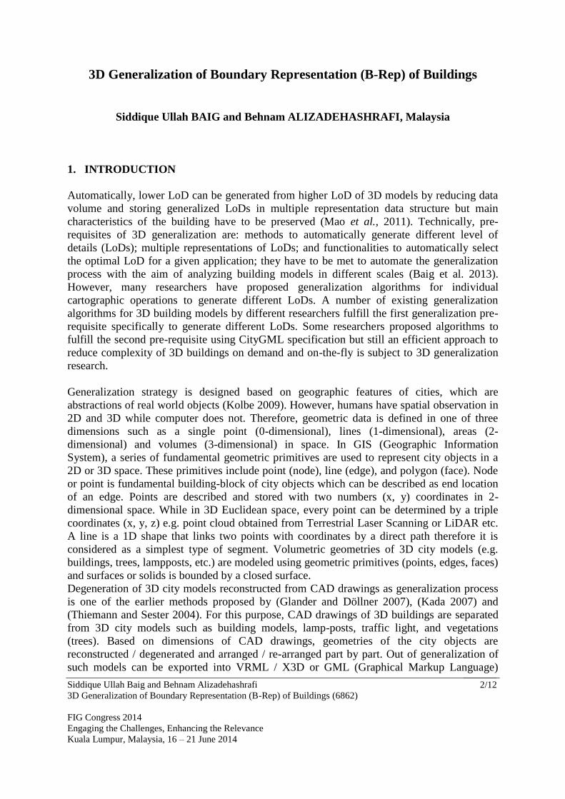
Smaller components e.g. windows, doors of each wall are projected and reduced to planes on
their exterior shell. Geometric characteristics of windows and doors within the wall are
preserved by projecting them onto the exterior or outer shell using following Equation (2.4)
(Fan et al. 2009).
[ ] [
] * (
) [
]+ *
+ (2.4)
In order to model a simple wall without any opening in LoD3, at least six polygons are
required. Therefore wall, windows as well as door in LoD3 are modelled as cuboid presented
in Figure 3.
Figure 3. Windows, walls and doors are modeled as cuboid (Fan and Meng 2009).
2.3 Establishment of Topological Relationship
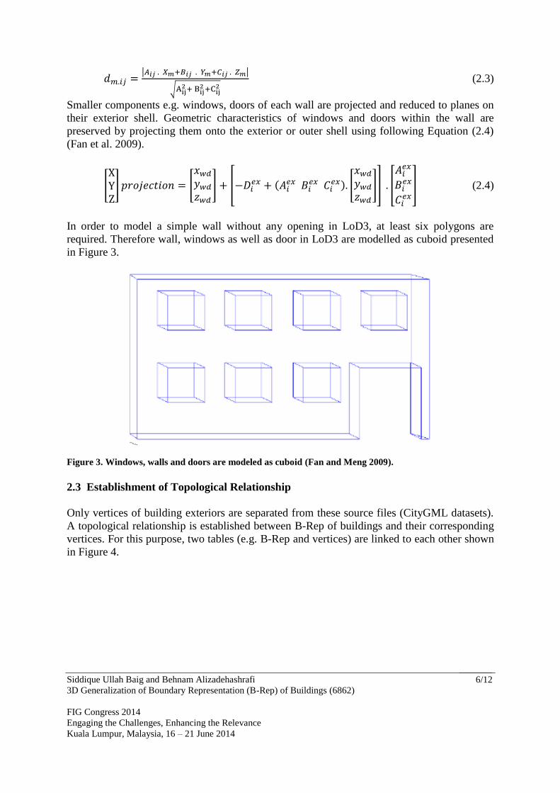
Only vertices of building exteriors are separated from these source files (CityGML datasets).
A topological relationship is established between B-Rep of buildings and their corresponding
vertices. For this purpose, two tables (e.g. B-Rep and vertices) are linked to each other shown
in Figure 4.

Siddique Ullah Baig and Behnam Alizadehashrafi
3D Generalization of Boundary Representation (B-Rep) of Buildings (6862)
FIG Congress 2014
Engaging the Challenges, Enhancing the Relevance
Kuala Lumpur, Malaysia, 16 – 21 June 2014
7/12
Figure 0. A topological relationship is established between boundaries of B-Rep (left) and their
corresponding vertices (right)
Based on these vertices, the edges are generated to be used for simplification and aggregation
purposes. Boundaries of buildings at LoD3 without windows and doors along with roof
structures are projected onto the horizontal ground plan. However, the geometry in a
CityGML data set in the form of nodes of surfaces can also be used.
In order to project extracted surfaces onto the ground, „z‟ or elevation values of each node are
removed. Roof structures are projected onto the ground while avoiding distortion in
orientation, length and width of surfaces. The wall surfaces for most of the buildings are
multi-polygons. Filling gap approach is applied to join two projected polygons with the aim to
form a single large polygon. Empty space between two points, lines or areas may be produced
due to projection onto the ground. This gap is filled by inserting additional vertices or points.
Interpolation methods such as „rhumb‟, great circle and „linear‟ interpolation are few of valid
interpolation methods being practiced to fill the gap between vector data coordinate points,
lines and polygons. In order to fill the gap between two polygons, we used interpolation
method and produced new latitude for a specified longitude. The longitudes must increase or
decrease monotonically. The methods returns interpolated points that lie on the line and
circles between input data. These interpolation method results in Linear or Cartesian between
the numerical values entered (lat1, lon1) and (lat2, lon2). Linear data points can also be
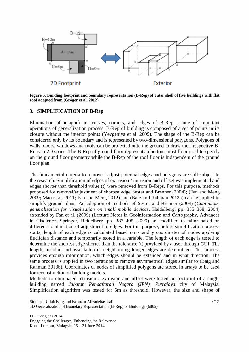
generated from interpolated points in reverse order. Figure 5 shows an illustration of
projection of surfaces of a simple building onto the ground and reconnecting into a single
polygon. The projection of flat roof outline and the ground plan are enclosed within each
other.
Siddique Ullah Baig and Behnam Alizadehashrafi
3D Generalization of Boundary Representation (B-Rep) of Buildings (6862)
FIG Congress 2014
Engaging the Challenges, Enhancing the Relevance
Kuala Lumpur, Malaysia, 16 – 21 June 2014
8/12
Figure 5. Building footprint and boundary representation (B-Rep) of outer shell of five buildings with flat
roof adapted from (Gröger et al. 2012)
3. SIMPLIFICATION OF B-Rep
Elimination of insignificant curves, corners, and edges of B-Rep is one of important
operations of generalization process. B-Rep of building is composed of a set of points in its
closure without the interior points (Yevgeniya et al. 2009). The shape of the B-Rep can be
considered only by its boundary and is represented by two-dimensional polygons. Polygons of
walls, doors, windows and roofs can be projected onto the ground to draw their respective B-
Reps in 2D space. The B-Rep of ground floor represents a bottom-most floor used to specify
on the ground floor geometry while the B-Rep of the roof floor is independent of the ground
floor plan.
The fundamental criteria to remove / adjust potential edges and polygons are still subject to
the research. Simplification of edges of extrusion / intrusion and off-set was implemented and
edges shorter than threshold value (t) were removed from B-Reps. For this purpose, methods
proposed for removal/adjustment of shortest edge Sester and Brenner (2004); (Fan and Meng
2009; Mao et al. 2011; Fan and Meng 2012) and (Baig and Rahman 2013a) can be applied to
simplify ground plans. An adoption of methods of Sester and Brenner (2004) (Continuous
generalisation for visualisation on small mobile devices. Heidelberg, pp. 355–368, 2004)
extended by Fan et al. (2009) (Lecture Notes in Geoinformation and Cartography, Advances
in Giscience. Springer, Heidelberg, pp. 387–405, 2009) are modified to tailor based on
different combination of adjustment of edges. For this purpose, before simplification process
starts, length of each edge is calculated based on x and y coordinates of nodes applying
Euclidian distance and temporarily stored in a variable. The length of each edge is tested to
determine the shortest edge shorter than the tolerance (t) provided by a user through GUI. The
length, position and association of neighbouring longer edges are determined. This process
provides enough information, which edges should be extended and in what direction. The
same process is applied in two iterations to remove asymmetrical edges similar to (Baig and
Rahman 2013b). Coordinates of nodes of simplified polygons are stored in arrays to be used
for reconstruction of building models.
Methods to eliminated intrusion / extrusion and offset were tested on footprint of a single
building named Jabatan Pendaftaran Negara (JPN), Putrajaya city of Malaysia.
Simplification algorithm was tested for 5m as threshold. However, the size and shape of

Siddique Ullah Baig and Behnam Alizadehashrafi
3D Generalization of Boundary Representation (B-Rep) of Buildings (6862)
FIG Congress 2014
Engaging the Challenges, Enhancing the Relevance
Kuala Lumpur, Malaysia, 16 – 21 June 2014
9/12
generalized surface depends on the threshold value (t=5m, 10m, 15m, etc.) value provided by
user. Figure 6 shows the result of simplification of B-Rep of footprints of two buildings based
on multiple parameters (t=5, 10, 15).
(a) (b)
(c) (d)
(e) (f)
Figure 6. Result of simplification of B-Rep of building footprints: (a) original footprint (b) simplified at
(t=5), (c) original footprint, (d, e) simplified footprints at (t=5 and t=10)
4. CONCLUSION AND DISCUSSION

Siddique Ullah Baig and Behnam Alizadehashrafi
3D Generalization of Boundary Representation (B-Rep) of Buildings (6862)
FIG Congress 2014
Engaging the Challenges, Enhancing the Relevance
Kuala Lumpur, Malaysia, 16 – 21 June 2014
10/12
The main focus of this paper was simplification of buildings represented as boundaries. For
this purpose, new approaches are implemented to restrict number of edges, curves, and
corners of ground plan of 3D building model on a certain LoD. Simplification of intrusion /
extrusion, offset and corners was implemented and edges shorter than threshold value (t) were
removed from ground plans by adopting methods proposed by Sester and Brenner (2004);
(Fan and Meng 2009; Mao et al. 2011; Fan and Meng 2012) and (Baig and Rahman 2013a).
The algorithms for derivation of LoD1 and LoD2 were tested for a small dataset containing 19
buildings at Putrajaya city of Malaysia.
REFERENCES
Baig S, Rahman A, Duncan E (2013) A Review and Conceptual Framework for Generalization of Maps. In:
Abdul Rahman A, Boguslawski P, Gold C, Said MN (eds) Developments in Multidimensional Spatial
Data Models. Lecture Notes in Geoinformation and Cartography. Springer Berlin Heidelberg, pp 191-
206. doi:10.1007/978-3-642-36379-5_12
Baig S, Rahman A (2013a) Generalization and Visualization of 3D Building Models in CityGML. In: Pouliot J,
Daniel S, Hubert F, Zamyadi A (eds) Progress and New Trends in 3D Geoinformation Sciences.
Lecture Notes in Geoinformation and Cartography. Springer Berlin Heidelberg, pp 63-77.
doi:10.1007/978-3-642-29793-9_4
Baig S, Rahman A (2013b) A three-step strategy for generalization of 3D building models based on CityGML
specifications. GeoJournal:1-8. doi:10.1007/s10708-013-9475-0
Eastman C (2012) What is BIM? http://bim.arch.gatech.edu/?id=402. Accessed 26 Jan 2012
Encarnação JL (1997) Graphische Datenverarbeitung 2, Modellierung komplexer Objekte und photorealistische
Bilderzeugung. Oldenbourg, München; Wien
Fan HC, Meng LQ Automatic derivation of different levels of detail for 3D buildings modelled by CityGML. In:
24th International Cartography Conference, Santiago, Chile, 15–21 November 2009.
Fan HC, Meng LQ (2012) A three-step approach of simplifying 3D buildings modeled by CityGML. Int J Geogr
Inf Sci 26 (6):1091-1107. doi:Doi 10.1080/13658816.2011.625947
Fan HC, Meng LQ, Jahnke M (2009) Generalization of 3D Buildings Modelled by CityGML. Lect Notes Geoinf
Ca:387-405. doi:Doi 10.1007/978-3-642-00318-9_20
Glander T, Döllner J Cell-based generalization of 3D building groups with outlier management. In: 15th annual
ACM international symposium on Advances in geographic information systems, Seattle, Washington,
November 07-09, 2007 2007. pp 364-367
Gröger G, Kolbe TH, Czerwinski A (2007) Candidate OpenGIS® CityGML Implementation Specification (City
Geography Markup Language). Open Geospatial Consortium, Inc.
http://www.opengeospatial.org/legal/. 0.4.0
Gröger G, Kolbe TH, Nagel C, Häfele K-H (2012) OGC City Geography Markup Language (CityGML) En-
coding Standard. OpenGIS® Encoding Standard, vol V.2.0.0. Open Geospatial Consortium.,
Guercke R, Brenner C (2009) A Framework for the Generalization of 3D City Models. Paper presented at the
12th AGILE International Conference on Geographic Information Science, Leibniz Universität

Siddique Ullah Baig and Behnam Alizadehashrafi
3D Generalization of Boundary Representation (B-Rep) of Buildings (6862)
FIG Congress 2014
Engaging the Challenges, Enhancing the Relevance
Kuala Lumpur, Malaysia, 16 – 21 June 2014
11/12
Hannover, Germany,
IFC (2009). http://www.ifcwiki.org/index.php/Main_Page. Accessed March 13, 2011
Kada M Generalization of 3D building models by cell decomposition and primitive instancing. In: joint ISPRS
workshop on „Visualization and exploration of geospatial data‟, Stuttgart, Germany, 2007.
KML (2012) Keyhole Markup Language. https://developers.google.com/kml/. Accessed 11 July 2009
Kolbe TH (2009) Representing and exchanging 3D city models with CityGML. In: Lee J, Zlatanova S (eds) 3D
Geo-Information Sciences: Lecture Notes in Geoinformation and Cartography. Springer,
Berlin/Heidelberg, pp 15-31
Kolbe TH, Nagel C, Stadler A CityGML – OGC Standard for Photogrammetry? In: Fritsch D (ed)
PhotogrammetricWeek 09, Stuttgart, Germany, 7–11 September 2009. Heidelberg: Wichmann Verlag,
pp 265–277
Mao B (2010) Visualisation and Generalisation of 3D City Models. Royal Institute of Technology (KTH),
STOCKHOLM, Sweden
Mao B, Ban YF, Harrie L (2011) A multiple representation data structure for dynamic visualisation of
generalised 3D city models. Isprs J Photogramm 66 (2):198-208. doi:DOI
10.1016/j.isprsjprs.2010.08.001
Pfund M (2002) 3D GIS Architecture A Topological Data Structure. GIM INTERNATIONAL 16 (2):35-37
Sester M, Brenner C Continuous generalization for visualization on small mobile devices. In: P. F (ed)
Developments in Spatial Data Handling - 11th International Symposium on Spatial Data Handling,
Berlin/Heidelberg, 2004. Springer, pp 355-368. doi:doi:10.1007/3-540-26772-7_27
Stadler A, Kolbe TH Spatio-semantic Coherence in the Integration of 3D City Models. In: 5th International
Symposium on Spatial Data Quality Enschede, 2007. p
Thiemann F, Sester M (2004) Segmentation of Buildings for 3D-Generalisation. Paper presented at the ICA
Workshop on Generalisation and Multiple Representation, Leicester, 20-21 August, 2004
X3D (2012) X3D. http://www.web3d.org/x3d/. Accessed 11 December 2011
Yevgeniya F, Martin K, Dieter F (2009) Quality Evaluation of Ground Plan Generalization. Paper presented at
the 12th AGILE International Conference on Geographic Information Science Leibniz Universität
Hannover, Germany,
BIOGRAPHICAL NOTES
Alias Abdul Rahman, is a full professor and the head of the 3D GIS group of the Faculty of Geoinformation
and Real Estate of the Universiti Teknologi Malaysia, Skudai, Malaysia. He worked as the dean of this faculty
for last two years.
Siddique Ullah Baig obtained an MSc in Photogrammetry and Geoinformatics in 2009 from Hochschule für
Technik, Stuttgart, Germany. In 2013, he defended his PhD (Geoinformatics) for this thesis „A three-step
strategy for generalization of three-dimensional buildings modelled in City Geography Markup Language‟. One
of his research paper was awarded ‟the second best paper – PhD Category‟ at Malaysian National Geomatic /
Geoinformatic Student competition in 2012.

Siddique Ullah Baig and Behnam Alizadehashrafi
3D Generalization of Boundary Representation (B-Rep) of Buildings (6862)
FIG Congress 2014
Engaging the Challenges, Enhancing the Relevance
Kuala Lumpur, Malaysia, 16 – 21 June 2014
12/12
CONTACTS
Alias Abdul Rahman
Department of Geoinformatics
Faculty of Geoinformation Science and Real Estate
Universiti Teknologi Malaysia
81310 UTM, Skudai, Johor Bahru,
MALAYSIA
Phone: +60-13-7490452
e-mail: [email protected]
website: www.utm.my
Siddique Ullah Baig
Department of Geoinformatics
Faculty of Geoinformation Science and Real Estate
Universiti Teknologi Malaysia
81310 UTM, Skudai, Johor Bahru,
MALAYSIA
Phone: +60-14-6137833
e-mail: [email protected]
website: www.siddiquebaig.com