3d design with prestack trace interpolation: a combined ... design for interpolation -...
TRANSCRIPT

3D design with prestack trace interpolation: a combined multi-survey seismic acquisition case
study Andrea Crook*, OptiSeis Solutions Ltd.;Balazs Nemeth and Christian Escalante, BHP Billiton; Ye Zheng and
Laurie Ross, Geo-X Exploration Services Inc.; Keith Millis, OptiSeis Solutions Ltd.
Summary
In this project, the feasibility of acquiring coarse-binned reconnaissance 3D surveys followed by target specific infill 3D surveys was investigated by decimating and then interpolating a regularly sampled orthogonal 3D. In total, eleven decimated datasets and two combined sparse/infill datasets were reprocessed with and without pre-stack trace interpolation (5D interpolation). Comparisons made with the original input dataset indicate that depending on the
target objectives, selective sparse acquisition geometry combined with 5D interpolation may be used for reconnaissance 3D exploration surveys. Furthermore, by designing target specific selective infill surveys with offset and azimuth distributions that complement the sparse geometry and then applying 5D interpolation to the merged sparse/infill surveys, data comparable to a regularly sampled survey was observed.
Introduction With the advent of 5D interpolation, the question of whether or not processing effort can reduce acquisition field effort for large regional 3D seismic surveys is more relevant. In order to assess the feasibility of acquiring sparse regional 3D surveys, a regularly sampled dataset
was decimated and then re-processed with 5D interpolation. Three types of decimations were compared: regular or random station decimation, regular line decimation and a combination of station and line decimation. Results from the decimation tests were then combined to mimic a multi-year survey where Year A represented a sparse regional survey and Year B represented an infill survey within the Year A survey.
Method The project was completed in two phases. The first phase focused on determining which sparse acquisition geometry produced the best 5D interpolation results. The second phase focused on the feasibility of acquiring multi-year combined sparse/infill 3D seismic surveys. The dataset chosen for the study was an orthogonal survey with source
and receiver station intervals of 60m, a receiver line interval of 180m and a source line interval of 300m (Figure 1). From an operational perspective, minimizing line kilometres by increasing the line interval will result in more cost savings than reducing the number of stations by increasing the station interval. However, larger line
intervals result in fewer near offsets and lower (bin size dependent) fold. Using these guidelines along with
minimum fold/trace density and attribute requirements, six decimated datasets (D1 - D6) were generated for analysis (Figure 2). These datasets examined source station/line decimation, source and receiver station/line decimation, and selective randomized source/receiver station decimation at one half and one quarter the trace density of the original survey.
In order to minimize the effects of geometry variation due to surface obstacles, each decimation was tested to determine which selection method produced the least fold variation at target. For example, source lines could be decimated by either selecting the first, third & fifth line. (Dataset A, Figure 3) or by selecting the second, fourth & sixth line (Dataset B, Figure 3). In this example, Dataset B was chosen since it had fewer source skids and offsets and
had a more regular fold distribution. Similar tests were conducted for each decimation type. These were cascading tests; for example, the sources removed in Decimation 1 were also removed in Decimation 2. Each decimated dataset was reprocessed from raw shots through to migration using the velocities and statics from the original dataset. This method enabled rapid processing
and allowed for direct analysis of the 5D interpolation algorithm since any variation in output would only be due to the geometry variations between the input datasets. The interpolation algorithm used for the tests was the Anti-Leakage Fourier Transform (ALFT) method which uses true coordinates of each trace rather than snapping input traces to bin centres (Xu et al, 2004). This method minimizes spatial smearing.
Comparisons of the different datasets were made before and after migration, with and without 5D interpolation both at the original bin size and double the bin size. Preliminary processing results indicated that station decimation provided reasonable results at a larger bin size. Therefore, a decision was made to generate four further datasets in order to test increased station decimation (station intervals were tripled). These datasets were migrated, but not interpolated.
After examining the processing results for all datasets, a sparse dataset that combined both station decimation and line decimation was generated. This dataset was then used to test the practicality of acquiring an infill survey within a sparse regional survey. Two different infill geometries were

3D design with prestack trace interpolation
selected from the initial decimation tests (one with station decimation and one with line decimation) and each one was merged with the sparse dataset. The combined datasets were then processed with and without 5D interpolation.
Results The analysis focused on four key areas: the effect of increasing the processing bin size, the ability of 5D interpolation to improve sparse datasets, the type of geometry decimation that produced the best 5D interpolation, and the best method to infill sparse 3D geometries in order to recover high resolution data.
Decimated datasets were compared at shallow and deep (time slices which correlated to areas of interest. Horizon flattened time slices, S/N, frequency content and difference volumes were also examined. One of the key objectives of this project was to determine the feasibility of acquiring sparse regional surveys. In the decimation tests, the bin size was doubled and tripled while
maintaining constant line intervals. As the bin size increased, stations were removed, which resulted in constant fold, but decreased trace density. All three bin sizes were capable of imaging large scale structures although small scale structures were not well imaged at the larger bin sizes. Additionally, test results do not account for the effect larger bin sizes may have on picking velocities and statics during processing since the decimated datasets
were reprocessed using the original velocities and statics. For reconnaissance 3Ds used to identify large scale structures, using a larger bin size may be an acceptable compromise in order to quickly and cost-effectively explore large areas. However, care must be taken to ensure that the reconnaissance design can be in-filled to achieve a higher resolution smaller bin size survey if required. Maintaining the desired final merged bin size in a least one direction may be beneficial.
All datasets were processed with and without 5D interpolation in order to determine if increased processing effort through prestack trace interpolation could reduce field effort on large scale, reconnaissance 3Ds. Examination of the initial interpolated data indicated that 5D interpolation significantly reduced acquisition footprint, and interpolated datasets were comparable with the
migrated datasets. For datasets with the same bin size the difference between low fold and high fold geometries was much less with 5D interpolation than without, indicating that interpolation may improve low fold data. Overall, 5D interpolation can improve large scale structural imaging for sparse geometry 3D surveys by reducing acquisition footprint and improving S/N.
The accuracy of the interpolation is dependent on the input geometry. In general, station decimation provided better structural imaging results than line decimations (Figure 4). Although decimating stations reduces acquisition costs by decreasing the total number of sources or receivers within a
program, it will not reduce the total linear kilometres unless the line intervals are increased, which may compromise near offset sampling. For the 5D interpolated datasets, bin size and trace density were less critical than ensuring well sampled offset and azimuth distributions. Selective station randomization provided some benefits in migration, but only when the randomization was designed for the natural bin size.
Similar results were observed for the combined sparse 3D / infill 3D tests. Infilling with a source station survey produced better results than infilling with a decimated source line 3D (Figure 5). The key factor for a successful infill survey was to ensure that the merged offset and azimuth sampling from both the sparse 3D survey and infill 3D survey were complimentary and met the minimum
target sampling criteria. Minimum sampling requirements may vary significantly from area to area.
Conclusions In this case study a regularly sampled dataset was decimated into different reduced source effort and/or reduced receiver effort surveys, and then re-processed with
or without 5D interpolation in order to determine the optimal method of acquiring sparse regional 3D surveys and target specific infill surveys. Test results indicated that, for the study area, decimating stations to achieve sparse geometry resulted in better 5D interpolated data than decimating lines. However, to improve operational efficiency during acquisition, a combined station/line decimation with selective randomization that maintains minimum trace density and offset/azimuth distribution may
be preferred. Furthermore, 5D interpolation can be used to merge complimentary infill surveys with sparse 3D geometries in order to obtain data that is comparable to a regularly sampled survey.
Acknowledgements Thanks to BHP Billiton for the permission to use the data
and publish this abstract.
3D design with prestack trace interpolation
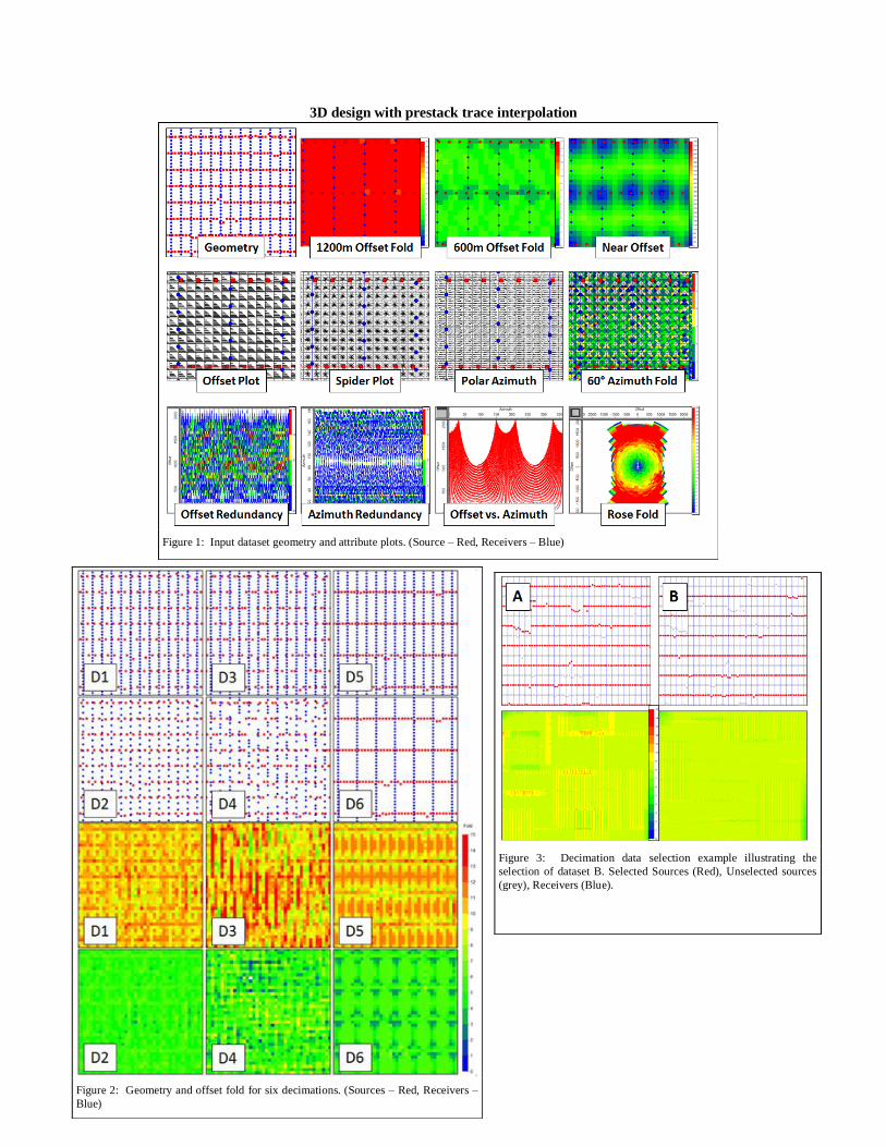
Figure 1: Input dataset geometry and attribute plots. (Source – Red, Receivers – Blue)
Figure 2: Geometry and offset fold for six decimations. (Sources – Red, Receivers –
Blue)
Figure 3: Decimation data selection example illustrating the
selection of dataset B. Selected Sources (Red), Unselected sources
(grey), Receivers (Blue).

3D design with prestack trace interpolation
Figure 4: Timeslices illustrating the effectiveness of 5D interpolation for various input geometries
Figure 4: Results of combining a sparse regional survey (A) with station (B) station or line (C) infill surveys