3.2 hydrology and water quality - san diego county, california€¦ · the results of this analysis...
TRANSCRIPT

3.2 Hydrology and Water Quality
December 2016 6653
Warner Ranch EIR 3.2-1
3.2 Hydrology and Water Quality
This section describes existing groundwater, surface water, water quality, stormwater, and flooding
conditions within the project area and evaluates potential impacts to hydrology and water quality
that could result from implementation of the project. These assumptions and associated analysis are
based on the following three reports prepared by Shapouri and Associates:
Preliminary Drainage Study (2013) (Appendix P)
Major Stormwater Management Plan (Major SWMP) (2013) (Appendix Q)
Preliminary Hydromodification Management Study (2015) (Appendix R)
Due to new requirements of Appendix “H” Guidance for Investigating Potential Critical Coarse
Sediment Yield Areas of Model BMP Design Manual for San Diego Region Dated June 2015, an
additional project level investigation was prepared to identify the presence of these coarse
sediment areas and further calculations were performed to quantify the pre and post project coarse
sediment tonnage towards the Point of Compliance (POC) which has been previously determined
to be located just upstream of the existing bridge (State Route (SR) 76, Pala Road) over Gomez
Creek. The results of this analysis are included as an attachment to Appendix R and are
summarized in Section 3.2.6, Non-CEQA Additional Information Regarding Coarse Sediment.
This section does not analyze coarse sediment in the context of the California Environmental
Quality Act (CEQA) for determination of environmental impact because there is no threshold
established at this time. Therefore, because there are no defined or adopted CEQA standards for
analyzing coarse sediment yield, the results are provided for information purposes only.
3.2.1 Existing Conditions
3.2.1.1 Hydrology
The Warner Ranch project is within the San Luis Rey River watershed. It is within the Pala
Hydrologic Subarea (903.21) of the Monserate Hydrologic Area (903.20), in the San Luis Rey
Hydrologic Unit (903.00). Almost the entire project is located within the watershed of Gomez
Creek (Figure 3.2-1, Gomez Creek Watershed). Beneficial Uses are listed as municipal water
supply, domestic water supply, industrial services water supply, and contact and non-contact
recreation. Beneficial Uses are not established on all watercourses, and in these cases the
Beneficial Uses are those of the receiving waters. As such, these may reflect more the uses of the
San Luis Rey River proper.
The mainstem of Gomez Creek runs generally north-to-south within Warner Ranch, just inside
the property’s western boundary (Figure 3.2-1). It passes under SR 76 and enters the San Luis
Rey River approximately 1 mile south of the property.

3.2 Hydrology and Water Quality
December 2016 6653
Warner Ranch EIR 3.2-2
The 513.0-acre property ranges in elevation from approximately 350 to 1,000 feet above mean
sea level. The overall basin reaches elevations of approximately 1,950 feet, and covers
approximately 6.4 square miles (Figure 3.2-1). The northern portions of the property have
moderate to steep slopes, with the southern portion more level. The project is not within a 100-
year floodplain area; its extreme southwest corner is within the mapped 500-year flood area
(Figure 3.2-2, Flood Zones). A part of the southwestern portion of the property is also within the
inundation area of Henshaw Dam (Figure 3.2-3, Henshaw Dam Inundation Zone).
The extreme northeast corner of the property is within the Pala Creek drainage, which runs
generally north to south along the west side of the Pala-Temecula Highway. The Pala Creek
basin is larger than the Gomez Creek basin (7.7 square miles; see Figure 3.2-4, Pala Creek
Watershed) with greater elevations, up to 3,400 feet. It has the same hydrologic designations and
the same Beneficial Uses as listed above for Gomez Creek. It also flows south under SR 76 to
enter the San Luis Rey River.
3.2.1.2 Surface Water Quality
No data are available on water quality from the seasonal flows of Gomez Creek or of any of the
ephemeral tributaries. Some groundwater data are available. Depth to groundwater in the general
area ranges between 4 and 40 feet, and the groundwater is relatively high in Total Dissolved
Solids (TDS), with ranges of 600 to 1400 milligrams per liter (Appendix J). Warner Ranch has
five wells in use. Water samples from these were tested in March of 2011. Test results show
TDS levels, ranging from 620 to 1,500 milligrams per liter (mg/L). At least some of this water is
used for irrigation, and, as such, could affect surface water runoff quality.
Dudek has done work on the property to include analyses of functions and values of the streams
and streamcourses (Appendix E). Both Gomez and Pala creeks have high flood storage and flood
flow modification abilities. Gomez Creek consists of a wide, incised, earthen-bottomed channel
surrounded by mature riparian vegetation, which flows relatively unrestricted. Pala Creek is
approximately 10 to 20 feet wide with similar flows. Both channels can hold and distribute water
for a period of time. The tributary in the eastern portion of the property is wide with herbaceous
vegetation that helps control flow, and would have moderate flood storage and flood flow
modification abilities. Other on-site ephemeral streams lack substantial width, depth, and
vegetation and thus have low flood storage and flood flow modification abilities.
Gomez Creek has areas of ponding and areas of herbaceous layers; this indicates that this
channel has high nutrient retention and transformation ability. Isolated wetlands in the eastern
portion of the site have many herbaceous plants within the channels, which could provide
moderate nutrient retention and transformation ability. Pala Creek and other waters on site lack
areas of ponding and herbaceous vegetation to filter chemicals and thus have a low nutrient
retention and transformation ability.

3.2 Hydrology and Water Quality
December 2016 6653
Warner Ranch EIR 3.2-3
Pala Creek has a wide, sandy bottom, indicating high groundwater recharge ability. Because
Gomez Creek has hydric soils as well as rocky areas providing slower percolation rates, it has
moderate groundwater recharge ability. Other on-site waters have low groundwater recharge
ability due to substrates, lack of sandy soils, and higher slopes.
A number of the small tributaries feeding Gomez Creek carry sediment during storm flow, and
the creek has a high sediment trapping ability due to its wide channel, areas for retention, and
presence of herbaceous vegetation in some areas. The remaining channels lack herbaceous
vegetation to slow flow and trap sediment, or have sufficiently steep slopes to preclude ponding,
and would be expected to have a low sediment trapping ability.
3.2.1.3 Groundwater
Water supply to the region is provided through individual wells and a number of different water
districts including the following: Rancho Pauma Mutual Water Company, the Yuima Municipal
Water District, the Mootamai Municipal Water District, the Valley Center Municipal Water
District, and the Rainbow Municipal Water District (RMWD). Areas in the southeast along
Valley Center Road have no specific water district.
The Rancho Pauma Water Company is not a County Water Authority member, and provides
water to its members within the area solely from individual wells. The Rancho Pauma Water
Company is only allowed to use imported water from the Yuima Municipal Water District during
emergencies like a fire. The Yuima Municipal Water District, the only County Water Authority
member within the region, services much of the surrounding area.
Of the 513.49-acre project site, 80.0 acres are located within the RMWD. The nearest water line
is to the north, approximately 1,600 feet from the property, and does not have a meter. RMWD
facilities are reasonably expected to be available within the next 5 years based on their capital
facility plans. The remaining acreage is not located within a water district.
The property is divided between two aquifer types; 30 percent of the site is an alluvial aquifer
type, and 60 percent is a fractured crystalline rock aquifer type.
Based on the Local Agriculture Resource Assessment (LARA) model, the property should be
classified based on the aquifer which provides the most water. In this case, that is the alluvial
aquifer type, which has a “moderate” rating. Laboratory tests on groundwater samples taken
from on-site wells indicate an average of 957.5 mg/L TDS. Guidelines for the LARA model
indicate if the site has groundwater with TDS levels above 600 mg/L, that the water rating may
be reduced by one level; therefore, the water rating for this area would become “low.” Details for
the laboratory results and testing methods are included within the Agricultural Analysis for
Warner Ranch, included within Appendix N.
3.2 Hydrology and Water Quality
December 2016 6653
Warner Ranch EIR 3.2-4
3.2.1.4 Flooding and Dam Inundation
Flooding is a general or temporary condition of partial or complete inundation of normally dry
land areas. Flooding is commonly associated with the overflow of natural rivers or streams, but
can also occur near stormwater facilities, dams, or in low-lying areas not designed to carry water.
Flooding can be induced by precipitation or as a result of increased rates and amounts of runoff
and altered drainage patterns. Additionally, flooding could result from dam failure, seiches, or
tsunamis. Dam inundation is flooding caused by the release of impounded water from structural
failure or overtopping of a dam. Seiches or tsunamis can result from abrupt movements of large
volumes of water due to earthquakes, landslides, volcanic eruptions, meteoric impacts, or
onshore slope failure. The project site is partially located within a 500-year mapped floodplain
and within a County Dam Inundation Zone.
3.2.2 Regulatory Setting
Federal Emergency Management Agency (FEMA)
This is the primary federal agency for coordination with communities to establish effective
floodplain management standards. FEMA prepares Federal Insurance Rate Maps (FIRMs).
FIRMs delineate the areas of special flood hazards and applicable risk premium zones. The
project site is not located within a mapped flood hazard area.
Federal Water Pollution Control Act (Clean Water Act)
The Clean Water Act (CWA) is the principal federal law for the regulation of water quality. The
CWA includes water quality standards, discharge limitations, and required permits. The
fundamental purpose of the CWA is the protection of designated beneficial uses of water
resources. The amendment of the CWA in 1987 includes a provision prohibiting discharges of
pollutants contained in storm water runoff and requires many cities to obtain a National Pollutant
Discharge Elimination System (NPDES) permit to control urban and stormwater runoff.
Section 303(d) of the CWA defines water quality standards as consisting of both the uses of
surface waters (beneficial uses) and the water quality criteria applied to protect those uses (water
quality objectives). State and regional water quality control boards have been charged with
ensuring that beneficial uses and water quality objectives are established for all waters of the state.
California Porter-Cologne Water Quality Control Act
This legislation establishes the responsibilities and authorities of the state’s nine Regional Water
Quality Control Boards (RWQCBs) and the State Water Resources Control Board (SWRCB). In
California, all surface waters and groundwater are considered to be “waters of the state” under
this act. Under this act, a Water Quality Control Plan for the San Diego Basin was developed
(San Diego Basin – Region 9).

3.2 Hydrology and Water Quality
December 2016 6653
Warner Ranch EIR 3.2-5
Sustainable Groundwater Management Act of 2014
On September 16, 2014, Governor Jerry Brown signed into law a three-bill legislative package
2014 [AB1739, SB1168, and SB1319] known as the Sustainable Groundwater Management Act
of 2014 (SGMA). The legislation provides a framework for sustainable management of
groundwater supplies by local authorities in high- and medium-priority alluvial basins, as
designated by the California Water Resources Control Board. The groundwater sustainability
agency, which can be a county, city or water district must be formed by June 30, 2017, and
would be required to prepare a groundwater sustainability plan by January 31, 2022 (or January
31, 2020 for critically overdrafted basins). Each plan requires implementation measures to bring
each basin into sustainability within 20 years of implementation of the plan. In San Diego
County, four basins have been designated to require plans, specifically the San Diego River
Valley Basin, San Pasqual Valley Basin, San Luis Rey River Basin, and Borrego Valley Basin
(all medium-priority basins). The proposed project overlies a portion of the San Luis Rey River
Groundwater Basin.
County of San Diego Watershed Protection, Storm Water Management, and Discharge
Control Ordinance
This ordinance stipulates discharge prohibitions and requirements per the type of land use and
location. These define the requirements that are legally enforceable by the County in the
unincorporated area.
San Diego Basin Plan
The Basin Plan for the San Diego Basin, most recently amended in 2007, sets forth water quality
objectives. Specifically, the Basin Plan is designed to accomplish the following: (1) designate
beneficial uses for surface and groundwater; (2) set the narrative and numerical objectives that
must be attained or maintained to protect the designated beneficial uses and conform to the
state’s anti-degradation policy; (3) describe mitigation measures to protect the beneficial uses of
all waters within the region; and (4) describe surveillance and monitoring activities to evaluate
the effectiveness of the Basin Plan. The Basin Plan incorporates by reference all applicable
SWRCB and RWQCB plans and policies.
County of San Diego Watershed Protection, Storm Water Management, and Discharge
Control Ordinance
The County of San Diego Watershed Protection, Storm Water Management, and Discharge
Control Ordinance (WPO) contains discharge prohibitions and requirements that vary depending
on type of land use activity proposed and location within the County. The intent of the WPO is to
protect water resources and improve water quality through the uses of management practices
aimed at reducing polluted runoff.

3.2 Hydrology and Water Quality
December 2016 6653
Warner Ranch EIR 3.2-6
San Diego Groundwater Ordinance
The County currently manages anticipated future groundwater demand through the County
Groundwater Ordinance. This ordinance does not limit the number of wells or the amount of
groundwater extraction from existing landowners. However, the ordinance does identify
specific measures to mitigate potential groundwater impacts of projects requiring specified
discretionary permits.
County of San Diego General Plan
The County’s General Plan Conservation and Open Space Element includes goals, policies, and
objectives regarding water resources. While surface water can drain through the County’s
watersheds, it can also be infiltrated into the subsurface saturated zone to become groundwater, a
resource that many residents of the unincorporated County depend upon. Aquifers are recharged
at varying rates depending upon a number of factors, primarily the amount and frequency of
rainfall. On average, the County’s coastal areas see less than 10 inches of rain per year, the
mountain peaks in excess of 40 inches, and the deserts less than 3 inches. Not only must the
County have sufficient quantities of groundwater, but the water must also be of a sufficient
quality. Watersheds facilitate the collection and transportation of sediments and pollutants that
can degrade water quality and damage downstream environments. Lakes and reservoirs capture
flows from many of these watersheds. Watershed management relates to sustaining watersheds at
an acceptable level of quality, contributing to resource surface and subsurface quality, and
maintaining groundwater supplies. Applicable General Plan policies include the following:
COS-4.1 Water Conservation. Require development to reduce the waste of potable water
through use of efficient technologies and conservation efforts that minimize the County’s
dependence on imported water and conserve groundwater resources.
COS-4.2 Drought-Efficient Landscaping. Require efficient irrigation systems and in new
development encourage the use of native plant species and non-invasive drought
tolerant/low water use plants in landscaping.
COS-4.3 Stormwater Filtration. Maximize stormwater filtration and/or infiltration in areas
that are not subject to high groundwater by maximizing the natural drainage patterns and the
retention of natural vegetation and other pervious surfaces. This policy shall not apply in
areas with high groundwater, where raising the water table could cause septic system failures,
moisture damage to building slabs, and/or other problems.
COS-4.4 Groundwater Contamination. Require land uses with a high potential to
contaminate groundwater to take appropriate measures to protect water supply sources.
3.2 Hydrology and Water Quality
December 2016 6653
Warner Ranch EIR 3.2-7
COS-5 Protection and Maintenance of Water Resources. Protection and maintenance of
local reservoirs, watersheds, aquifer‐recharge areas, and natural drainage systems to
maintain high‐quality water resources.
COS-5.1 Impact to Floodways and Floodplains. Restrict development in floodways and
floodplains in accordance with policies in the Flood Hazards section of the Safety Element.
Development in floodways and floodplains has the potential to alter natural hydrologic
flow and cause soil erosion and increased stormwater runoff—including loss of wetland
and health issues related to surface and groundwater contamination.
COS-5.3 Downslope Protection. Require development to be appropriately sited and to
incorporate measures to retain natural flow regimes, thereby protecting downslope areas
from erosion, capturing runoff to adequately allow for filtration and/or infiltration, and
protecting downstream biological resources.
COS-5.5 Impacts of Development to Water Quality. Require development projects to
avoid impacts to the water quality in local reservoirs, groundwater resources, and recharge
areas, watersheds, and other local water sources.
3.2.3 Analysis of Project Effects and Determination as to Significance
3.2.3.1 Hydrology
Guidelines for the Determination of Significance
The County of San Diego has established guidelines for determining significance of impacts to
hydrology (County of San Diego 2007a). A project will generally be considered to have a
significant effect if it proposes any of the following, absent specific evidence to the contrary:
The project will substantially alter the existing drainage pattern of the site or area, including
through the alteration of the course of a stream or river, in a manner which would result in
substantial erosion or siltation on- or off-site.
The project will increase water surface elevations in a watercourse within a watershed
equal to or greater than one square mile, by one foot or more in height and in the case of
the San Luis Rey River, San Dieguito River, San Diego River, Sweetwater River, and Otay
River, two-tenths of a foot or more in height.
The project will result in increased velocities and peak flow rates exiting the project site
that would cause flooding downstream or exceed the stormwater drainage capacity
serving the site.

3.2 Hydrology and Water Quality
December 2016 6653
Warner Ranch EIR 3.2-8
The project will result in placing housing, habitable structures, or unanchored impediments
to flow in a 100-year floodplain area or other special flood hazard area, as shown on a
FIRM, a County Flood Plain Map, or County Alluvial Fan Map, which would subsequently
endanger health, safety, and property due to flooding.
The project will place structures within a 100-year flood hazard or alter the floodway in a
manner that would redirect or impede flow resulting in any of the following:
o Alter the Lines of Inundation resulting in the placement of other housing in a 100-year
flood hazard; OR
o Increase water surface elevation in a watercourse with a watershed equal to or greater
than one square mile by one foot or more in height and in the case of the San Luis Rey
River, San Dieguito River, San Diego River, Sweetwater River, and Otay River, two-
tenths of a foot or more in height.
Analysis
Stormwater runoff analyses and ensuing design are tied to Gomez Creek at its crossing under SR
76 (Appendix P). Runoff from the open space lands north and northeast of the project will flow
as in existing conditions, and then enter the project’s storm drain system. The project includes a
project design feature as follows:
PDF-HY-1. The project design includes four bio-retention ponds, four dry-detention
ponds, and three vegetated swales. These project design feature would move runoff into the
ponds, and then to the swales, and then to Gomez Creek in order to decrease flow and
improve water quality before it enters the creek.
These components are shown on Figure 3.2-5, Hydromodification Components. More detail is
shown on the oversize figure in Appendix R. All components have been designed using the peak
discharge of the 100-year storm event. Component connections are by various sized (24-inch to
66-inch diameter) pipes (Appendix P). During the peak discharge of the 100-year storm event,
the mainstem Gomez Creek watershed is projected to carry approximately 5,402 cubic feet of
water per second (cfs). The project development area described above is projected to carry
approximately 375 cfs of that total. The proposed drainage facilities have been designed to
adequately convey the 100-year flood conditions. The project would result in an overall minor
decrease in flows as compared to the current conditions (approximately 5,402 cfs versus
approximately 5,697 cfs. As such, flows in the mainstem of Gomez Creek as it passes under SR
76 and to the San Luis Rey River would be slightly less than under existing conditions.
As shown on Figure 3.2-5, the project includes PDF-HY-1, which would result in the development of
four dry-detention ponds, four bio-retention ponds, and three vegetated swales. Best Management

3.2 Hydrology and Water Quality
December 2016 6653
Warner Ranch EIR 3.2-9
Practice (BMP) 1 is a dry-detention pond in the northeastern portion of the project. Rainfall flows are
directed through streets and landscape areas, through curb inlets, and into the storm drain system to
this pond. BMP 1 has an area of approximately 1.1 acres. BMP 2 is also a dry detention pond. It is
located in the southeastern portion of the site and has an area of approximately 1.9 acres. BMP 3 is a
bio-retention basin located just north of BMP 2 with an area of approximately 2.45 acres (Figure
3.2-5). Runoff is directed through streets and landscape areas and then to this pond.
BMP 4 is a dry detention pond located in the central portion of the project, just east of the main
access road. It covers approximately 0.9 acres. Runoff is directed via curb inlets to the storm
drain system, and then into this pond. BMP 5 is the proposed dry detention pond in the southwest
corner of the property. It has an area of approximately 1.6 acres, and also receives flows directed
through street flows and landscape areas before entering the storm drain system.
BMP 6 and BMP 7 are both bio-retention ponds located in the south-central portion of the project, on
either side of the main access road. The pond of BMP 6 covers approximately 0.25 acres; the pond of
BMP 7 covers approximately 0.2 acres. Runoff is directed into these from street flows and
landscaped areas via the storm drain system. BMP 8 is also a bio-retention pond, located north of
BMP 3 and south of BMP 1, with an area of approximately 1.42 acres (Figure 3.2-5).
Outflows from these BMP ponds—water that does not percolate into the substrate—are routed
through the various vegetated swales before eventually flowing to Gomez Creek.
As required by federal, State, and County regulations, less than significant hydrology impacts
would occur under the various significance criteria:
Substantial erosion or siltation from an altered drainage pattern. The project would
maintain the existing overall drainage patterns, and would not result in substantial erosion
or siltation on- or off-site. All areas presently draining to Gomez Creek would continue to
do so, and all areas presently draining to Pala Creek would continue to do so. The proposed
basins and swales have been designed and sized to prevent storm runoff from resulting in
substantial erosion or siltation on site. Off-site erosion or siltation now occurring would be
lessened, as the flows leaving the site would be less than in the current situation, and the
basins and swales would retain sediment. Impacts from siltation or erosion would be less
than significant.
Increase in water surface elevations. The project will not increase water elevations
in a watercourse by one foot or more and will not increase surface water elevations in
the San Luis Rey River by two-tenths of a foot or more. Flows exiting the property to
Gomez Creek would be less than at present. Present flows under the 100-year storm
event are estimated at 5,697 cfs; post-project flows are estimated at 5,402 cfs. Flows
in Pala Creek at the point it flows off the property are presently estimated at 6,294

3.2 Hydrology and Water Quality
December 2016 6653
Warner Ranch EIR 3.2-10
cfs, and are projected to remain at that quantity. Impacts from water surface elevation
would be less than significant.
Flooding from increased velocities or peak flow rates. The project will not result in
increased velocities and peak flow rates exiting the site that would cause flooding
downstream or exceed the stormwater drainage capacity. As noted above, the flows exiting
the site would not have increased velocities or peak flow rates. Impacts from increased
velocities or peak flows would be less than significant.
Impediments to flow. The project will not place housing, habitable structures, or
unanchored impediments to flow in a 100-year floodplain area or 100-year flood hazard
area or other special flood hazard area. Project structures are not proposed within the 100-
year floodplain (Figure 3.2-4). The southwestern corner of the property is within the 500-
year flood zone, but all proposed structures in that area are at an elevation of at least 562
feet, with the flood zone projected at 555 feet. Similarly, while the inundation map includes
some areas of the property, that is based on existing elevations. The maximum inundation
from dam failure at Lake Henshaw would run along the 562 foot elevation, with structures
above that elevation (Figure 3.2-6, Inundation Zone), Impacts from placement of any
project components affecting flows or lines of inundation would be less than significant.
3.2.3.2 Water Quality
Guidelines for the Determination of Significance
The County of San Diego has established two sets of guidelines for determining significance of
impacts to water quality, one for surface water quality (County of San Diego 2007b) and one for
groundwater resources (County of San Diego 2007c). This latter document concerns
groundwater use, which the project does not propose. As such, the guidelines for surface water
quality are used here. A project will generally be considered to have a significant effect if it
proposes any of the following, absent specific evidence to the contrary:
The project is a development project listed in County of San Diego, Code of Regulatory
Ordinances (Regulatory Ordinances), Section 67.804(g), as amended and does not comply
with the standards set forth in the County Stormwater Standards manual, Regulatory
Ordinances Sect 67.813, as amended, or the Additional Requirements for Land Disturbance
Activities, as set forth in Regulatory Ordinances, Section 67.
The project would drain to a tributary of an impaired water body listed on the Clean Water
Act Section 303(d) list, and will contribute substantial additional pollutant(s) for which the
receiving water body is already impaired.
The project would drain to a tributary of a drinking water reservoir and will contribute

3.2 Hydrology and Water Quality
December 2016 6653
Warner Ranch EIR 3.2-11
substantially more pollutant(s) than would normally run off from the project site under
natural conditions.
The project will contribute pollution in excess of that allowed by applicable State or local
water quality objectives or will cause or contribute to the degradation of beneficial uses.
The project does not conform to applicable Federal, State or local “Clean Water” statutes or
regulations including but not limited to the Federal Water Pollution Control Act, California
Porter-Cologne Water Quality Control Act, and the County of San Diego Watershed
Protection, Stormwater Management, and Discharge Control Ordinance.
Analysis
The following discussion of impacts is organized into two subsections: (1) short-term
construction activities and (2) long-term post-construction use.
Short-Term Construction Activities
Proposed grading, excavation, and construction activities associated with the project could
create a substantial additional source of polluted runoff which could have short-term impacts
on surface water quality. These activities could include demolition, clearing and grading,
excavation, stockpiling of soils and materials, and other typical construction activities.
Pollutants associated with construction would degrade water quality if they are washed into
surface waters. Sediment is often the most common pollutant associated with construction sites
because of the associated earth-moving activities and areas of exposed soil. Hydrocarbons such
as fuels, asphalt materials, oils, and hazardous materials such as paints and concrete discharged
from construction sites could also result in impacts downstream. Debris and trash could be
washed into existing storm drainage channels to downstream surface waters. These activities
could impact aquatic habitat, upland wildlife, and aesthetic land values. Under the NPDES
permit program, BMPs are identified for construction sites greater than 1 acre, in order to
reduce the occurrence of pollutants in surface water. In compliance with applicable
construction permits and the County WPO, a Major SWMP has been developed for the project
to identify a preliminary list of BMPs, which would be implemented as project design features,
to minimize disturbance, protect slopes, reduce erosion, and limit or prevent various pollutants
from entering surface water runoff (Appendix Q).
As detailed in the Major SWMP, the project’s temporary construction BMPs could include the
following: street sweeping, waste disposal, vehicle and equipment maintenance, concrete
washout area, materials storage, minimization of hazardous materials, and proper handling and
storage of hazardous materials (Appendix Q). Typical erosion and sediment control measures
include: silt fences, fiber rolls, gravel bags, temporary desilting basins, velocity check dams,

3.2 Hydrology and Water Quality
December 2016 6653
Warner Ranch EIR 3.2-12
temporary ditches or swales, stormwater inlet protection, and soil stabilization measures.
Implementation of these measures, as project design features, would assure that short-term
impacts from construction-related activities would not violate any water quality standards or
waste discharge requirements. Impacts would be less than significant.
Long-Term Post Construction Uses
As discussed in Section 3.2.3.1, Hydrology, the project includes four bio-retention ponds, four dry-
detention ponds, and three vegetated swales in the Gomez Creek drainage. These components are
shown on Figure 3.2-5. Other pertinent Low Impact Development (LID) strategies have been
incorporated into project design, including curb-cuts to landscaping from impervious surfaces,
pavements pitched toward landscaping, and downspouts to vegetated swales.
Beneficial Uses are listed as municipal water supply, domestic water supply, industrial services
water supply, and contact and non-contact recreation. Some of these uses are based on receiving
waters, and have little applicability to the project. Five groundwater wells presently exist to serve
residences, workers and agricultural uses on site. Existing recreation uses, as much as they do
exist, would be walking or hiking along Gomez Creek, observing birds and other wildlife
attracted to the riparian habitats. This would not change with the project.
Analyses of waters potentially jurisdictional under the federal CWA and the state Porter-Cologne
Water Quality Control Act were conducted in 2013 by Dudek (Appendix E). Design
modifications were made to the project to avoid some impacts, and proposed mitigation for
residual impacts is included in their analyses. The project will be conditioned to have the
required permits under both federal and state requirements.
Compliance with the County of San Diego Watershed Protection, Stormwater Management, and
Discharge Control Ordinance has been completed with the Major SWMP and the Preliminary
Hydromodification Management Study. The proposed hydromodification facilities at Warner
Ranch will fall under second and third category maintenance mechanisms, as defined within the
County of San Diego “Standard Urban Storm Mitigation Plan Requirements for Development
Applications,” dated January 8, 2011. The on-site BMPs constructed during the ultimate build-
out will fall under the second category maintenance mechanisms, requiring that a Stormwater
Facilities Maintenance Agreement, with Easement and Covenants, be entered into between the
owner and the County, obliging the owner/homeowners association (HOA) to maintain the
project category 2 BMPs in perpetuity. Prior to recordation of the agreement, the
owner/developer will provide the County with security to back up the maintenance agreement,
which shall remain in place for an interim period of 5 years. The BMPs servicing public right-of-
way (SR 76) will fall under the third category maintenance mechanisms, requiring the
establishment of a stormwater maintenance assessment district to maintain the BMPs in

3.2 Hydrology and Water Quality
December 2016 6653
Warner Ranch EIR 3.2-13
perpetuity. The primary funding mechanism will be a special assessment under the authority of
the Flood Control District (Appendix R).
Based on the project design and applicable requirements, and in particular with the inclusion of
the above ponds, swales, and other LID strategies, the following conclusions are made:
The projects studies demonstrate that the project does comply with Regulatory
Ordinances and with the standards set forth in the County Stormwater Standards manual.
Therefore, less than significant impacts to water quality would occur under the
requirements of these ordinances and standards.
The project drains to Gomez Creek, which is a tributary of the San Luis Rey River. While the
river is an impaired water body listed on the CWA Section 303(d) list, the project will not
contribute additional pollutant(s) for which the receiving water body is already impaired.
Therefore, less than significant impacts to water quality of Gomez Creek and impaired
water bodies would occur.
The project does not drain to a tributary of a drinking water reservoir. No impacts to the
water quality of a drinking water reservoir would occur.
The project studies demonstrate that it does not contribute pollution in excess of that
allowed by applicable state or local water quality objectives or cause or contribute to the
degradation of beneficial uses. Therefore, less than significant impacts to water quality
from pollution contribution would occur.
The project studies demonstrate that it does conform to applicable federal, state, or local
“Clean Water” statutes or regulations including but not limited to the Federal Water Pollution
Control Act, California Porter-Cologne Water Quality Control Act, and the County of San
Diego Watershed Protection, Stormwater Management, and Discharge Control Ordinance.
Therefore, less than significant impacts to water quality would occur as defined by these
statutes and regulations.
3.2.3.3 Groundwater Supplies and Recharge
Guidelines for the Determination of Significance
Based on Appendix G of the California Environmental Quality Act (CEQA) Guidelines (14 CCR
15000 et seq.), a project would have a significant adverse environmental effect if the project
would substantially deplete groundwater supplies or interfere substantially with groundwater
recharge such that there would be a net deficit in aquifer volume or a lowering of the local
groundwater table level (e.g., the production rate of pre-existing nearby wells would drop to a
level which would not support existing land uses or planned uses for which permits have been
granted). In addition to the CEQA Appendix G guideline, above, the County identifies conditions

3.2 Hydrology and Water Quality
December 2016 6653
Warner Ranch EIR 3.2-14
that, if met, would be considered a significant impact to groundwater resources (County of San
Diego 2007c). These additional guidelines focus on groundwater quantity and the project’s effect
on groundwater storage, overdraft, and well interference. A significant impact would result if a
soil moisture balance, or equivalent analysis, conducted using a minimum of 30 years of
precipitation data, including drought periods, concludes that at any time groundwater in storage
is reduced to a level of 50 percent or less as a result of groundwater extraction.
Analysis
Groundwater Depletion
Five groundwater wells currently serve the project site. The wells serve the residences, workers
and agricultural uses (approximately 172.2 acres of agricultural use, including citrus groves,
avocado groves and extensive agriculture). Based on an assessment of the existing agricultural
uses, it was determined that the water wells produce, on average, approximately 689 acre-feet per
year; see Figure 3.2-7, Existing Well Water Usage. The citrus and extensive agricultural uses
would be removed entirely by the proposed project. A portion of the existing avocado grove would
remain and would continue to require approximately 181 acre-feet of non-potable water per year.
As detailed in the Water Supply Assessment, included as a part of Appendix L to this EIR, water
supplies necessary to serve the proposed project’s needs have been accounted for in the RMWD
2010 Urban Water Management Plan, and it has been demonstrated that there would be
sufficient water supplies to meet the project’s demands. The Water Supply Assessment indicates
the total project water demands are 536 acre-feet per year. Non-potable water use for the
proposed project includes 302 acre-feet for irrigation (22 acre-feet for parks, 97 acre-feet for fuel
modification areas, 14 acre-feet for common areas, and 170 acre-feet for private landscaped
areas) and 181 acre-feet for avocado groves. The project’s anticipated non-potable water needs
that would be served by the wells are 486 acre-feet per year and would not exceed the current use
of 593 acre-feet per year. In addition, per project design feature PDF-AE-3, drought-tolerant,
deer-tolerant, and native species shall be used wherever possible to minimize water usage and
maintain the visual and rural character of the natural environment; refer to Section 2.1,
Aesthetics, for details. Therefore, the project would not substantially deplete groundwater levels
and impacts would be less than significant.
For added assurance, the project would include metering at the wells and the following project
design feature would be implemented as a condition of the project:
PDF-HY-2. Groundwater production shall be monitored at least monthly at all pumping
wells. Groundwater production data shall be reported to the County of San Diego
Groundwater Geologist on an annual basis and shall document the previous calendar year
groundwater production. If the project site exceeds a total of 593 acre-feet in any given

3.2 Hydrology and Water Quality
December 2016 6653
Warner Ranch EIR 3.2-15
calendar year, groundwater pumping shall cease for the remainder of that year. The HOA
would be responsible for management of the wells.
Groundwater Quality
A significant impact would result if groundwater resources proposed to be used as a potable
water source exceeded state or federal maximum contaminant level (MCL). No use of
groundwater for potable water supplies to the project is proposed. Therefore, impacts are less
than significant.
3.2.3.4 Erosion or Siltation/Flooding
Guidelines for the Determination of Significance
Based on Appendix G of the CEQA Guidelines, a project would have a significant adverse
environmental effect if the project would substantially alter the existing drainage pattern of the
site or area, including through the alteration of the course of a stream or river, in a manner which
would result in substantial erosion or siltation on or off site, or substantially increase the rate or
amount of surface runoff in a manner which would result in flooding on or off site.
Analysis
The following discussion of impacts is organized into two subsections: (1) short-term
construction activities and (2) long-term post construction use. Hydromodification refers to the
changes in stream flows as a result of development such as increases in impervious areas,
decreases in natural vegetation, and grading and compacting of soil, which could lead to impacts
on the receiving waters in terms of erosion, sedimentation, and degradation of habitat.
Short-Term Construction Activities
Project grading, excavation, and construction activities could increase the potential for erosion
and sedimentation. Additionally, on-site use and storage of construction-related hazardous
materials could result in significant impacts to surface water quality if such materials reach
downstream receiving waters.
As discussed above, a Major SWMP was prepared for the project providing a preliminary list
of LIDs and BMPs as project design features to be employed during temporary construction
activities (Appendix R). The implementation of these features would avoid erosion and water
quality impacts by minimizing site disturbance during construction. Impacts would be less
than significant.

3.2 Hydrology and Water Quality
December 2016 6653
Warner Ranch EIR 3.2-16
Long-Term Post-Construction Uses
The project includes the construction of roadways, single-family residences, mixed-use
residences, parks, a fire station, and a pump station. These new uses could result in permanent
alterations to existing drainage patterns by converting areas to impervious surfaces. Allowing the
permanent development of impervious surfaces could increase runoff and potentially result in
new or the worsening of existing erosion problems. State and local regulations including the
NPDES, which requires the development of a hydromodification management plan, and the
County WPO assure that the project would account for such alterations in drainage. The project
is required to use LID techniques, and BMPs to maintain existing area hydrology. On-site
riparian areas are further protected from long-term runoff on site through dedicated buffers and
open space easements intended to preserve the integrity of wetland vegetation.
The project’s HMP provides calculations of anticipated increases of flow volumes and
hydromodification measures to be employed by the project to reduce and eliminate potential
impacts to receiving waters. Adding all grading limits and fire management buffer areas, the total
disturbed area would be approximately 164 acres; see Table 2.3-7 in Section 2.3, Biological
Resources, of this EIR.
The proposed impervious areas are estimates based on the lot size, where the areas within each
type’s building envelop is assumed to be impervious, the roadway areas are calculated based on
the length and width of the roads along with the length of proposed sidewalks. The impervious
areas are based on the lot size and projected impervious percentage—70 percent impervious for
residential, 80% for the Community Center, and 90% for the Fire Station.
Under post-development conditions, the project design includes four bio-retention ponds, four
dry-detention ponds, three vegetated swales, and within each of the sub-basins to alleviate the
anticipated excess runoff as a result of the increase in impervious areas. The proposed ponds are
designed for placement within each sub-basin and are adequately sized to store all the excessive
runoff. Their outlet structures, which would include riprap, would restrict the peak runoff rate
exiting these ponds at or below that of under the predevelopment conditions. Specifically, acre-
feet for detention ponds (for hydromodification only) and for sub-basins a, b, and c, respectively,
are included in the project design; refer to Appendix R. Through implementation of these design
features, the proposed development would have a less than significant impact on downstream
drainage facilities.
The project would maintain the existing overall drainage patterns, and would not result in
substantial erosion or siltation on or off site. All areas presently draining to Gomez Creek would
continue to do so, and all areas presently draining to Pala Creek would continue to do so.
Specific project features that implement these policies and regulations are included in the project
design to ensure that the intended environmental protections are achieved. These include the

3.2 Hydrology and Water Quality
December 2016 6653
Warner Ranch EIR 3.2-17
features identified in the Drainage Study, Major SWMP, and HMP discussed above and detailed
in Appendix P, Appendix Q, and Appendix R, respectively.
The proposed basins and swales have been designed and sized to prevent stormwater runoff
from resulting in substantial erosion or siltation on site. Off-site erosion or siltation now
occurring would be lessened, as the flows leaving the site would be less than in the current
situation, and the basins and swales would retain sediment. The Drainage Study concluded that
the incorporation of the requisite LIDs, BMPs, and hydromodification design features would
reduce impacts associated with excessive erosion or siltation, and on- or off-site flooding to
less than significant.
3.2.3.5 Housing within 100-Year Flood Hazard Area
The project will not place housing, habitable structures, or unanchored impediments to flow in a
100-year floodplain area or 100-year flood hazard area or other special flood hazard area. Project
structures are not proposed within the 100-year floodplain (Figure 3.2-4). The southwestern
corner of the property is within the 500-year flood zone, but all proposed structures in that area
are at an elevation of at least 562 feet, with the flood zone projected at 555 feet. Therefore,
impacts from placement of any project components affecting flows or lines of inundation would
be less than significant.
3.2.2.6 Dam Inundation
While the Dam Inundation Maps include some areas of the property, they are based on existing
elevations. The maximum inundation from dam failure at Lake Henshaw would run along the
562 foot elevation. All project structures would be at or above that elevation (Figure 3.2-6).
Therefore, impacts from placement of any project components affecting flows or lines of
inundation would be less than significant.
3.2.4 Cumulative Impact Analysis
Guidelines for the Determination of Significance
Guidelines for determination of significance of cumulative impacts to hydrology/water quality
are the same as those used for direct impacts, as listed above.
3.2.4.1 Hydrology
The project would have a less than significant contribution to cumulative impacts to area
hydrology. The stormwater runoff system has been designed for the 100-year peak runoff storm
event, and results in slightly less runoff than in the current situation for both Gomez and Pala

3.2 Hydrology and Water Quality
December 2016 6653
Warner Ranch EIR 3.2-18
creeks, which are the receiving waters (Appendix P). As such, the project would not contribute to
increased peak flows or increased velocities resulting in substantial siltation or erosion. Two
potential projects are proposed in the upstream Pala Creek drainage. Vista Towers (No. 31) and
the Pala Temecula II Wireless Facility (No. 94) would be located in the drainage, approximately
5 miles upstream of the Warner Ranch project, but the Warner Ranch project does not propose
alteration of the Pala Creek watershed so it does not contribute to its cumulative impacts. Either
of these could contribute to cumulative impacts to the hydrology of Pala Creek. Both projects
will be subject to conditions set by the County and RWQCB that will ensure less than significant
impacts to hydrology of Pala Creek and the receiving waters of the San Luis Rey River.
3.2.4.2 Water Quality
The project would have a less than significant contribution to cumulative impacts to area water
quality as mandated by regulatory compliance. The stormwater runoff system has been designed
for the 100-year peak runoff storm event, and results in slightly less runoff than in the current
situation (see Appendix Q). BMPs incorporated into the project would reduce levels of pollutants
to less–than-significant impacts. Discontinuation of most orchard production and large animal
raising would eliminate or greatly reduce potential pollutants associated with manure and
pesticides and herbicides. While the mainstem of Gomez Creek would continue to flow as under
current conditions, the project area with its basins and swales would likely contribute less
sediment to stormwater runoff than presently occurs.
As noted in Section 3.2.4.1, Hydrology,Vista Towers (No. 31) and the Pala Temecula II Wireless
Facility (No. 94) would be located in the Pala Creek drainage, approximately 5 miles upstream
of the Warner Ranch project (Figure 1-27, Table1-5). Either of these could contribute to
cumulative impacts to the water quality of San Luis Rey River, together with the proposed
project. All three cumulative projects will be subject to the strict regulations set by the County
and RWQCB that will ensure less than significant impacts to water quality in Pala Creek and the
San Luis Rey River.
3.2.4.3 Groundwater Supplies and Recharge and Groundwater Quality
Groundwater extraction, proposed by the project for irrigation and landscaping needs, is not
anticipated to exceed the current amount of withdraw from active on-site wells (593 acre-
feet/year). Therefore, it is not anticipated that the project would substantially deplete groundwater
levels and the project would not contribute to a cumulatively considerable impact.
3.2.4.4 Erosion or Siltation/Flooding
Cumulative projects identified in this analysis would result in multiple developments that could
potentially alter existing drainage patterns in a manner that could result in substantial erosion,

3.2 Hydrology and Water Quality
December 2016 6653
Warner Ranch EIR 3.2-19
siltation, or on- or off-site flooding. It is reasonably foreseeable that some cumulative projects
would occur simultaneously, which would compound the impacts. Cumulative projects could be
expected to increase impervious surfaces within the area; however, each project would be
required to conform to regulations and policies resulting in each project’s reduction of
potentially polluted runoff during and after construction. Additionally, each project would be
required to maintain pre-development discharge rates and volumes of runoff.
The project includes design features, including construction BMPs, stormwater LID and BMPs,
and hydromodification/detention basins that would avoid potential erosion, siltation, and
flooding impacts or reduce such impacts to less than significant levels. Therefore, the project, in
combination with the identified cumulative projects, would have a less–than-significant
cumulative impact associated with erosion, siltation, and flooding on and off site.
3.2.4.5 Housing within 100-Year Flood Hazard Area
It is expected that cumulative projects would be required to comply with applicable regulations
that would prevent the construction of structures in floodways and floodplains. Therefore,
through regulation, a cumulative impact would not occur. The project would not place any
structures within a 100-year floodplain; therefore, in combination with the identified cumulative
projects, would not result in a cumulatively considerable impact associated with impeding or
redirecting flood flows.
3.2.4.6 Dam Inundation
Multiple regulations exist, including local regulatory policies, that would be expected to avoid
any potential impacts. A cumulative impact would not occur. Therefore, the project, in
combination with the identified cumulative projects, would not contribute to a significant
cumulative impact associated with dam inundation.
3.2.5 Conclusion
Significant impacts will be avoided by project design to control stormwater runoff in terms of
both quantity of runoff (hydrology) and quality of runoff (water quality). These requirements and
the BMPs and LID design features of the project. Therefore, impacts to hydrology and water
quality would be less than significant with implementation of mitigation.
3.2.6 Non-CEQA Additional Information Regarding Coarse Sediment
Pursuant to requirements of Appendix “H” Guidance for Investigating Potential Critical Coarse
Sediment Yield Areas of Model BMP Design Manual for San Diego Region (dated June 2015),
the two existing watershed basins for this project have been further analyzed. It was determined
3.2 Hydrology and Water Quality
December 2016 6653
Warner Ranch EIR 3.2-20
that potential coarse sediment areas do exist within the drainage boundaries of the project. As
part of the proposed project design, additional project level investigation has been conducted by
the project applicant to accurately identify the extent of the coarse sediment areas and quantify
the pre and post project coarse sediment tonnage to the Point of Compliance (POC)
The project level analysis Geomorphic Landscape Units (GLU) was determined based on
existing and proposed slopes, geology and land cover categories for the entire watershed
contributing to the POC. The entire watershed is subdivided into two major basins; the large
basin containing the Gomez creek watershed is predominantly untouched by the proposed
development and the smaller basin on the east side is also mostly undisturbed. Based on the pre
and post development coarse sediment flow tonnage estimates, as documented in an attachment
to Appendix R, implementation of the project would not result in a net loss of coarse sediments
tonnage flow.

FIGURE 3.2-1
Gomez Creek WatershedWARNER RANCH PROJECT - ENVIRONMENTAL IMPACT REPORT
SOURCE: Shapouri/Dudek
6653

3.2 Hydrology and Water Quality
December 2016 6653
Warner Ranch EIR 3.2-22
INTENTIONALLY LEFT BLANK

FIGURE 3.2-2
Flood ZonesWARNER RANCH PROJECT - ENVIRONMENTAL IMPACT REPORT
SOURCE: Shapouri/Dudek
6653

3.2 Hydrology and Water Quality
December 2016 6653
Warner Ranch EIR 3.2-24
INTENTIONALLY LEFT BLANK
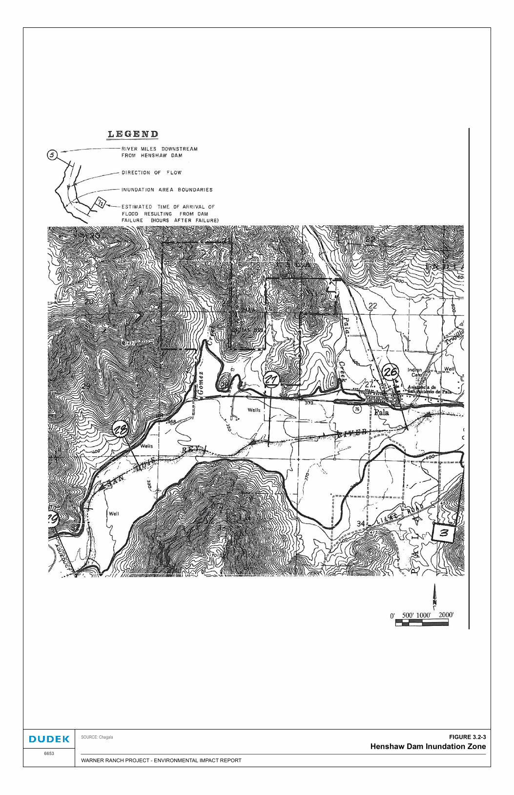
FIGURE 3.2-3Henshaw Dam Inundation Zone
DRAFT/FINALWARNER RANCH PROJECT - ENVIRONMENTAL IMPACT REPORT6653
SOURCE: Chagala

3.2 Hydrology and Water Quality
December 2016 6653
Warner Ranch EIR 3.2-26
INTENTIONALLY LEFT BLANK