3.16 visual effects and neighborhood … visual effects and neighborhood character ... final peir...
TRANSCRIPT
3.16 Visual Effects and Neighborhood Character
Draft General Plan City of San Diego Final PEIR 3.16-1 September 2007
3.16 VISUAL EFFECTS AND NEIGHBORHOOD CHARACTER 3.16.1 Existing Conditions Regional Setting San Diego is a city in a region with unique and varied landscapes – ocean, bays, and beaches, estuaries and river valleys, canyons and mesas, hills and mountains, and desert. Much of the City is situated in the coastal plain portion of southwestern San Diego County. This coastal plain slopes gently upwards to the eastern foothills and has been eroded into separate mesas. Numerous side canyons have incised the coastal plain and created major drainages which generally flow westward towards the coast. These major drainages are the San Dieguito River, Los Peñasquitos Canyon, Carroll Canyon, Rose Canyon, San Diego River, Los Chollas Creek, Sweetwater River, Otay River, and the westernmost mouth of the Tijuana River (City of San Diego Strategic Framework Element Final EIR, 2002). Alongside these canyons and foothills are the many large mesas that serve as the foundation of various San Diego neighborhoods. These large mesas have developed into unique communities that are physically bounded by distinct natural barriers, namely the major east-west canyons. The City canyon system and steep hillsides are illustrated on Figure 3.16-1. While development has occurred in Mission Valley and portions of other drainages, efforts to provide open space and reduce land use intensity in San Dieguito River Valley, Los Peñasquitos Canyon, San Clemente Canyon, and the Otay River Valley allows the City of San Diego an opportunity to retain and/or develop unique communities with distinct physical separation (City of San Diego Strategic Framework Element Final EIR, 2002). San Diego’s location bordering the Pacific Ocean also contributes to the natural setting of the area. In fact, many of San Diego’s most appreciated natural resources are located within the coastal zone. These include the City’s beaches, bays, shoreline, coastal canyons and the many rivers, streams and other watercourses that drain inland areas, eventually reaching the coastal environment and waters. In the City of San Diego, the Coastal Zone encompasses approximately 40,000 acres of public and private land and waters. Figure 3.8-3 (See Land Use section) illustrates the Coastal Zone boundary that was established by the Coastal Commission by way of the California Coastal Act.
Neighborhood and community borders are often defined by San Diego’s interstate and highway system. Communities are connected through a system of transportation networks including major arterial freeways, highways, surface streets and public transportation routes. Available modes of public transportation include buses and regional light rail trains that link San Diego with other municipalities in the county. The City is also connected to the larger statewide and national transportation networks through established train lines and interstate freeways. Close proximity to Mexico and the presence of the federal ports of entry connect the City to the international arena as well. The area also enjoys a number of state designated scenic highways, which include portions of State Route 75 (SR-75), SR-78, SR-163, and SR-125.

3.16 Visual Effects and Neighborhood Character
Draft General Plan City of San Diego Final PEIR 3.16-2 September 2007
Nearly 28 percent of all existing land use in San Diego consists of parks, open space and recreation areas. These areas are reserved for environmental protection and/or public recreation. Preserving parks and open space areas protects San Diego’s unique natural landscape and scenic beauty. Natural scenic vistas can be seen from the 36,000 acres of recreational and open space parks in the City, such as Mission Trails Regional Park, Marian Bear Memorial Park , Rose Canyon Open Space Park and Tecolote Canyon Natural Park & Nature Center, San Diego River Park, Los Peñasquitos Canyon Preserve, Black Mountain Open Space Park, and San Pasqual/Clevenger Canyon Open Space Park. In addition to scenic vistas and highways, public views are also identified in community plans. Although most community plans make some reference to public views, the detail varies from plan to plan with many plans making little or no reference to public views. See Table 3.16-1. In the community plans that do identify public views, the views are typically those which overlook or face a body of water, most often the Pacific Ocean, however, community plans also identify views overlooking canyons, the Centre City skyline, and open space. In 1972, voters approved Proposition D which restricts the building height in areas generally west of Interstate 5 (I-5) to 30 feet. Prior to the adoption of Proposition D, multiple dwelling unit developments in San Diego were built to accommodate a range of densities at varying heights. Since the adoption of Proposition D, the bulk and scale of buildings has become more uniform as property owners seek to maximize development potential within the 30-foot height limit. The City of San Diego’s Utilities Undergrounding Program is also improving views in neighborhoods. The City has been undergrounding lines since 1970, and the program is currently relocating approximately 30-35 miles of overhead utility lines underground throughout the City each year. It is estimated that nearly all major and collector streets will be completed within the next 20 years and streets in residential areas within approximately 50 years. The Utilities Undergrounding Program will help beautify neighborhoods and clear up views by hiding utility lines. San Diego’s communities, and the landscapes and transportation networks that frame and link them, are the City’s basic building blocks. In the past, the pattern of development in San Diego has occurred on large vacant tracks of land. Currently, vacant land considered to be developable accounts for 3.6 percent or 6,756 acres of the City’s total acreage. Vacant land is limited, and redevelopment and infill development is occurring in many parts of the City. The City is and will continue to experience infill development and redevelopment in urbanized communities, and a number of areas have qualified as redevelopment project areas in order to stimulate improvements within communities. The California Community Redevelopment Law authorizes the City of San Diego to use special legal and financial mechanisms to eliminate blight and improve economic and physical conditions in designated areas of the City. San Diego’s Redevelopment Agency was created in 1958 and currently manages redevelopment areas within the City’s jurisdiction. Redevelopment activities in the Redevelopment Agency’s 17 project areas are carried out by the City’s Redevelopment Division and two public, nonprofit City corporations: Centre City Development Corporation and Southeastern Economic Development Corporation. These project areas, located

3.16 Visual Effects and Neighborhood Character
Draft General Plan City of San Diego Final PEIR 3.16-3 September 2007
in various parts of the City, encompass more than 11,700 acres. Figure 3.16-2 identifies the 17 project areas and provides the associated acreage for each project area. Redevelopment is a tool used to improve deteriorated areas plagued by social, physical, environmental or economic conditions that act as a barrier to new investment by private enterprise. Infill development and redevelopment can stimulate visual improvements that contribute to revitalizing neighborhoods and restoring unique neighborhood qualities. The following is a summary of various redevelopment area objectives and should not be considered an exclusive and/or exhaustive list: • Eliminate and prevent blight and deterioration. • Create an attractive and pleasant environment. • Preserve the historic character of commercial and residential districts. • Improve the appearance and character of industrial and commercial uses. • Explore opportunities for mixed uses. • Revitalize deteriorated commercial corridors. • Retain and expand neighborhood supporting businesses. • Enhance economic growth. • Expand and diversify employment opportunities and create living wage jobs. • Develop affordable multifamily and senior housing. • Provide affordable and market-rate housing opportunities and rehabilitation. • Preserve existing housing stock. • Improve the flow of traffic, enhance transportation and parking facilities. • Improve public infrastructure and improve and/or develop public facility assets. • Enhance and expand entertainment, cultural, and recreational opportunities. • Resolve environmental issues. • Address urban runoff and industrial pollution. • Support habitat conservation and restoration.
The intent of redevelopment is primarily to eliminate blight from designated areas, as well as to achieve the goals of development, reconstruction and rehabilitation of residential, commercial, industrial, and retail districts. Each redevelopment area has individual objectives tailored to meet the needs of the community as described below.
Barrio Logan - The 133-acre Barrio Logan Redevelopment Project Area is located in a mixed-use community near Downtown San Diego at the foot of the San Diego/Coronado Bay Bridge. The project area is located along the San Diego harbor, close to the San Diego Convention Center, Centre City East Village and the ballpark redevelopment project. It is adjacent to Downtown, and is located near all forms of transportation and the San Diego Bay.
City Heights - The City of San Diego’s 1,984-acre City Heights Redevelopment Project Area, comprised of various community planning areas, focuses on education and beautification of the community. The project area is bounded by Home and Euclid Avenues and 54th Street to the east, Meade and Monroe Avenues to the north, Home Avenue to the south, and Interstate 805 to the west. The centerpiece of the project area is the City Heights Urban Village, a public/private

3.16 Visual Effects and Neighborhood Character
Draft General Plan City of San Diego Final PEIR 3.16-4 September 2007
partnership effort that encompasses nine City blocks. Other focus areas include the Interstate 15 corridor and the University Avenue and El Cajon Boulevard commercial corridors.
College Community - The City of San Diego’s 131-acre College Community Redevelopment Project Area focuses on student housing needs, transportation planning, parking and public improvements. The project area is located immediately adjacent to the southern boundary of San Diego State University. It is primarily bounded by College Avenue to the east, the SDSU campus on the north, Montezuma Road to the south, and 55th Street to the west. The project area also includes the Montezuma Elementary School and a portion of the Alvarado Medical Plaza. The City is working with private developers to provide adequate student housing. Development has begun on several student housing projects, and a large mixed-use project is in the planning stage.
College Grove - The City of San Diego’s 167-acre College Grove Redevelopment Project Area was adopted in 1986 to revitalize the aging College Grove Shopping Center by using tax increment revenue to finance street-related improvements around the shopping center for better traffic circulation. The project area, administered by the City’s Redevelopment Division, comprises the 56-acre shopping center on College Avenue and State Route 94, and 111 acres of City land, including Chollas Lake Park and Chollas Landfill.
Crossroads - The City of San Diego’s 1,031-acre Crossroads Redevelopment Project Area and Redevelopment Plan was established by the City Council on May 6, 2003. The focus of the Redevelopment Plan is twofold: to revitalize the properties along El Cajon Boulevard, University Avenue, Streamview Drive and College Avenue and the residential neighborhoods of Chollas Creek and Fox Canyon; and to develop the Resource-Based Parkland at Chollas Park.
Grantville - The City of San Diego’s 990-acre Grantville Redevelopment Project Area was adopted in 2005. The Project Area is located in eastern San Diego and encompasses part of the Navajo Community, the Tierrasanta Community, and the College Area Community. The Project Area includes portions of the San Diego River, and it is located in close proximity to Mission Valley, Mission Trails Park and San Diego State University. The goals of the Grantville Redevelopment Project Area and Redevelopment Plan are to remove physical and economic blighting conditions and to ensure the continued economic viability of the commercial, industrial and retail uses within the Project Area.
Linda Vista - The City of San Diego’s 12-acre Linda Vista Redevelopment Project Area was adopted in 1972 to facilitate the redevelopment of the Linda Vista Shopping Center, San Diego’s oldest shopping complex. The Linda Vista Shopping Center includes the City Redevelopment Agency-owned Skateworld roller skating rink and the Linda Vista Library. The project area also contains Morley Strip, a small linear public park that runs parallel to Linda Vista Road. The project area is located in the heart of the Linda Vista community at the intersection of Linda Vista Road and Ulric Street. This redevelopment project area expires in 2012.
Naval Training Center - The City adopted a final Reuse Plan in October 1998, charting a new course for Naval Training Center (NTC). The former NTC is proposed to be a new urban village called Liberty Station. New homes, parks, businesses, as well as cultural and educational

3.16 Visual Effects and Neighborhood Character
Draft General Plan City of San Diego Final PEIR 3.16-5 September 2007
facilities will transform the former Navy base into a vital waterfront community. The City NTC Reuse Plan calls for a pristine area surrounded by green landscaping and bordered by water, with a focus on NTC’s history. This new community will anchor revitalization of the northern portion of San Diego Bay. It will also support education, training and research and development programs attracting new industries to San Diego.
North Bay - The City of San Diego’s 1,360-acre North Bay Redevelopment Project Area is composed of a variety of land uses that are designated for residential, mixed-use, high technology office/flex/Research and Development (R&D), light industrial and retail development opportunities along I-5, Pacific Highway, Morena Boulevard, India Street, Loma Portal, Voltaire Street and in the City’s Midway District. The project area is centrally located two miles from Downtown, is adjacent to the San Diego International Airport, is accessible by two major freeways, and has both light-rail and heavy-rail transportation for employees and freight.
North Park - The City of San Diego’s 555-acre North Park Redevelopment Project Area is centrally located within 5 miles of Downtown San Diego and adjacent to Balboa Park. It is bounded by Interstate 805 to the east and Park Boulevard to the west and stretches as far north as Adams Avenue and as far south as Upas Street. Redevelopment in the project area focuses on the revitalization of North Park’s commercial corridors, with special attention paid to the revitalization of the El Cajon Boulevard and University Avenue corridors. Historic preservation and public art are incorporated features within the redevelopment focus. San Ysidro - The City of San Diego’s 766-acre San Ysidro Redevelopment Project Area was established to create a world-class gateway between the cities of San Diego and Tijuana. The project area is located on the United States-Mexico border where Interstates 5 and 805 merge. It also includes a corridor along the San Diego Trolley route with retail and residential land. The project area focuses on redeveloping a vital business district, attracting new businesses to the area, and encouraging continued tourism from American and Mexican visitors.
Downtown - The Centre City Development Corp (CCDC) was established in 1975 to carry out redevelopment activities in Downtown San Diego. Its project areas comprise approximately 1,490 acres and include two redevelopment project areas: Horton Plaza and Centre City (Core/Columbia, Cortez, East Village, Gaslamp Quarter, Little Italy, Marina). The Horton Plaza Redevelopment Project was adopted in 1972 and Centre City Redevelopment Project was adopted in 1992. The two redevelopment areas provide a comprehensive communitywide approach to reverse blight and deterioration and encourage and establish a Downtown core for government, financial, commercial, and cultural activities integrated with distinct residential neighborhoods (Centre City Development Corporation 2004).
Southeastern area – The Southeastern Economic Development Corp (SEDC) was established in 1981 to carry out redevelopment in southeastern San Diego. SEDC project areas comprise of approximately 1,055 acres. The SEDC administers four redevelopment project areas and one study area.
Central Imperial - The 580-acre Central Imperial Redevelopment Project Area was established in 1992. It is located east of Messina Drive across Interstate 805 and 69th Street

3.16 Visual Effects and Neighborhood Character
Draft General Plan City of San Diego Final PEIR 3.16-6 September 2007
and includes portions of Chollas View, Emerald Hills, Lincoln Park, Mountain View, Valencia Park, Encanto and South Encanto neighborhoods.
Gateway Center West - The 59-acre Gateway Center West Redevelopment Project Area was
established in 1976. It is bound on the west by 32nd Street, by Highway 15 to the east, south by Market Street and north by Highway 94.
Mount Hope - The 210-acre Mount Hope Redevelopment Project Area was established in
1982. It is located north and south of Market Street between Interstate 805 and Highway 15. Southcrest - The 301-acre Southcrest Redevelopment Project Area was established in 1986.
It is bounded on the west by Highway 15 and I-5, to the east by 44th Street, south by Gamma and Vesta Streets and north of Logan Avenue.
Dells Imperial Study Area - The Dells Imperial Study Area is approximately 980-acres
immediately adjacent to Downtown San Diego and located within two historic districts: Sherman Heights and Grant Hills.
It is likely new redevelopment areas will occur over time. As newer neighborhoods age, there will be more redevelopment opportunities. Meeting the City’s growth needs through infill and redevelopment compliments the City’s strategy for protecting canyons and open spaces. San Diego’s built environment spans over 200 years of architectural history. The real urbanization of the City as it is today began in 1869 when Alonzo Horton moved the center of commerce and government from Old Town (Old San Diego) to New Town (Downtown). Development spread from Downtown based on a variety of factors, including the availability of potable water and transportation corridors. Factors such as views and access to public facilities affected land values, which in turn affected the character of neighborhoods that developed. Many of San Diego’s neighborhoods are the product of small incremental parcelizations and development over a long period of time. Neighborhood character is defined in part by certain physical qualities that repeat throughout neighborhoods, such as landscape and massing of buildings, colors, and materials. The character of a neighborhood or community is also defined by factors including topography and natural features, street layout and streetscape, and landmarks and civic land uses.
Urban design describes the physical features that define the character or image of a street, neighborhood, community, or the City as a whole. Urban design is the visual and sensory relationship between people and the built and natural environment. The built environment includes buildings and streets, and the natural environment includes features such as shorelines, canyons, mesas, and parks as they shape and are incorporated into the urban framework. Citywide urban design recommendations are intended to ensure that the built environment continues to contribute to the qualities that distinguish the City of San Diego as a unique living environment.
Among the recognized architectural styles in San Diego are Spanish Colonial, Pre-Railroad New England, National Vernacular, Victorian Italianate, Stick, Queen Anne, Colonial Revival,

3.16 Visual Effects and Neighborhood Character
Draft General Plan City of San Diego Final PEIR 3.16-7 September 2007
Neoclassical, Shingle, Folk Victorian, Mission, Craftsman, Monterey Revival, Italian Renaissance, Spanish Eclectic, Egyptian Revival, Tudor Revival, Modernistic and International. Examples of every major period and style remain, although few areas retain neighborhood-level architectural integrity due to several major building booms when older structures were demolished prior to preservation movements and stricter regulations regarding historic structures. (McAlester and McAlester 1990) 3.16.2 Thresholds of Significance A significant impact could occur if implementation of the General Plan: Results in a substantial change in the topography or ground surface relief features of any
areas of the City; Allows development that is incompatible in shape, form, or intensity such that public views
from designated open space areas, scenic highways or to any significant visual landmarks or scenic vistas (e.g., mountains, bays, rivers, ocean) would be substantially blocked; or
Results in projects that would negatively and substantially alter the existing character of the
City’s distinct neighborhoods. 3.16.3 Impact Analysis Could implementation of the proposed General Plan result in a substantial change in the topography or ground surface relief features of any areas of the City? The Draft General Plan calls for future growth to be focused into mixed-use activity centers. Implementation of the Plan would result in infill and redevelopment occurring in selected built areas, which would be identified through the community plan update/amendment process. The Draft General Plan would also guide the development of remaining developable vacant land. As new development occurs, changes to the landform may occur through site-specific grading. For example, new development may require significant on-site grading for development with larger footprints. The City has policies and regulations which aim to preserve hillside areas throughout the City. Steep hillsides are shown on Figure 3.16.1. In general, steep hillsides are protected from excessive development by the City’s Environmentally Sensitive Lands (ESL) regulations. Steep hillsides is defined in the Municipal Code Chap 11 Art 3 Div 1 §113.0103 as “all lands that have a slope with a natural gradient of 25 percent (four feet of horizontal distance for every one foot of vertical distance) or greater and a minimum elevation differential of 50 feet, or a natural gradient of 200 percent (one foot of horizontal distance for every two feet of vertical distance) or greater and a minimum elevation differential of ten feet.” The ESL regulations are applied to both publicly- and privately-owned property.
3.16 Visual Effects and Neighborhood Character
Draft General Plan City of San Diego Final PEIR 3.16-8 September 2007
The Draft General Plan provides policies which help reduce the potential for significant impacts to topography and ground surface relief features. For example, the Urban Design Element addresses the natural environment, preserving open space systems and targeting new growth into compact villages through urban form and design policies. There are several policies in the Draft General Plan which discuss environmentally sensitive development. The policies are intended to contribute to the qualities that distinguish San Diego as a unique living environment and highlight the value of open space resources as part of the overall built environment. Examples of Draft General Plan policies related to topography and ground surface relief features are as follows: 1. Avoid or minimize disturbances to natural landforms. 2. Contour manufactured slopes to blend with the natural topography. 3. Apply the appropriate zoning and regulations to limit development of floodplains, wetlands,
steep hillsides, canyons, and coastal lands. 4. Preserve and protect natural landforms and features.
5. Protect the integrity of community plan designated open spaces.
6. Continue to implement the Multiple Species Conservation Program (MSCP) to conserve San Diego’s natural environment and create a linked open space system. Preserve and enhance remaining naturally occurring features such as wetlands, riparian zones, canyons, and ridge lines.
Aside from policies in the Draft General Plan which address topography and sensitive development, the City relies on Environmentally Sensitive Lands regulations to identify environmental resources at a site specific level. The City’s Environmentally Sensitive Lands (ESL) regulations help protect, preserve, and restore lands containing steep hillsides, sensitive biological resources, coastal beaches, sensitive coastal bluffs, or Special Flood Hazard Areas. The intent of the ESL regulations is to assure that development occurs in a manner that protects the overall quality of the resources, encourages a sensitive form of development, retains biodiversity and interconnected habitats, maximizes physical and visual public access to and along the shoreline, and reduces hazards due to flooding in specific areas while minimizing the need for construction of flood control facilities. The regulations provide supplemental development regulations to the underlying zone to assure that development occurs in a manner that protects the natural and topographical character of these areas. While the Draft General Plan policies are designed to minimize impacts to topography and ground surface relief features, there is no guarantee that all future implementation actions and development projects will adequately implement Draft General Plan policies. Assuming a site is underutilized based on planned land use and zoning, new development could potentially change the landscape of the built environment and result in grading and a change in ground surface relief features in order to maximize the development potential of a particular site. Since no specific development project is proposed at this time, no project-level mitigation can be developed at this time to address potential environmental impacts. Environmental analysis would be required for any such future action or project; identification of project-level mitigation

3.16 Visual Effects and Neighborhood Character
Draft General Plan City of San Diego Final PEIR 3.16-9 September 2007
measures would be determined at that time. Implementation of the above mentioned Draft General Plan policies and compliance with established development standards would serve to reduce impacts to a degree, but cannot guarantee that all future project level impacts will be avoided or mitigated to a level less than significant. Because the degree of impact and applicability, feasibility, and success of these measures can not be accurately predicted for each specific project at this time, the program level impacts related to changes in topography and ground surface relief features are considered significant and unavoidable. Could implementation of the proposed General Plan allow development that is incompatible in shape, form, or intensity such that public views from designated open space areas, scenic highways or to any significant visual landmarks or scenic vistas (e.g., mountains, bays, rivers, ocean) would be substantially blocked? With limited developable vacant land, the Draft General Plan anticipates future growth will likely occur along transportation corridors and within established urbanized areas. As new development occurs, a transition in building mass, form, and intensity is likely to occur in many areas of the City. For example, an existing commercial corridor which is currently characterized as having one- and two-story structures with surface parking may transition into a corridor with multistory structures and underground parking. The same commercial corridor which, in the past, may have been primarily commercial could redevelop with mixed uses, introducing new building types and forms. This new development and redevelopment may have the potential to block public views of scenic resources such as mountains, bays, rivers and the ocean. With growth expected to occur along transportation corridors, blocked views are most likely to occur as people travel on the public rights of way. However, views of important resources from designated open space areas, such as the City’s parks and recreation areas could also be substantially changed. Table 3.16-1 provides a list of identified public vantage points identified in community plans. Community plans that identify public views are typically those which overlook a body of water, canyons and open space, and/or the Centre City skyline. The Draft General Plan provides policies which help reduce the potential for impacts to public views. The Draft General Plan addresses the natural environment, preserving open space systems and targeting new growth into compact villages through urban form and design policies. More specifically, the Urban Design Element contains policies which address development adjacent to natural features and reduce visual impacts to scenic areas or viewsheds. Relevant policies include:
1. Identify state highways where the City desires to preserve scenic qualities and work with California Department of Transportation (CALTRANS) to pursue official scenic highway designation.
2. Designate scenic routes along City streets to showcase scenic vistas and to link points of visitor interest.
3. Adopt measures to protect aesthetic qualities within scenic highways and routes. 4. Design development adjacent to natural features in a sensitive manner to highlight and
complement the natural environment in areas designated for development. 5. Utilize a clustered development pattern, single-story structures or single-story roof
elements, or roofs sloped toward the open space system or natural features, to ensure that
3.16 Visual Effects and Neighborhood Character
Draft General Plan City of San Diego Final PEIR 3.16-10 September 2007
the visibility of new developments from natural features and open space areas are minimized.
6. Provide increased setbacks from canyon rims or open space areas to ensure that the visibility of new development is minimized.
7. Screen development adjacent to natural features as appropriate so that development does not appear visually intrusive, or interfere with the experience within the open space system. The provision of enhanced landscaping adjacent to natural features could be used to soften the appearance of or buffer development from the natural features.
8. Ensure that the visibility of new development from natural features and open space areas is minimized to preserve the landforms and ridgelines that provide a natural backdrop to the open space systems. For example, development should not be visible from canyon trails at the point the trail is located nearest to proposed development. Lines-of-sight from trails or open space system could be used to determine compliance with this policy.
9. Protect views from public roadways and parklands to natural canyons, resource areas, and scenic vistas.
10. Protect and conserve the landforms and open spaces that: define the City’s urban form; provide public views/vistas; serve as core biological areas and wildlife linkages; are wetlands habitats; provide buffers within and between communities, or provide outdoor recreational opportunities.
11. Convert overhead utility wires and poles, and associated overhead structures for supplying electric, communication, community antenna television, or similar service to underground.
The Draft General Plan addresses preservation of the natural environment and scenic vantage points, as well as provides design objectives to minimize visual impacts and screen new development from open space areas. While the Draft General Plan policies are designed to minimize impacts to public views, there is no guarantee that all future implementation actions and development projects will adequately implement Draft General Plan policies. As a result, in areas where public views of scenic resources exist, direct impacts could occur. As future growth occurs in the City, any development that is incompatible in shape, form, or intensity such that public views are impacted, will be analyzed and addressed in project-specific environmental reviews pursuant to the California Environmental Quality Act (CEQA). Identification of appropriate project level mitigation measures would be determined at that time. Implementation of the above mentioned Draft General Plan policies and future compliance with established development standards would serve to reduce impacts to a degree, but cannot guarantee that all future project level impacts will be avoided or mitigated to a level less than significant. Because the degree of impact and applicability, feasibility, and success of these measures can not be accurately predicted for each specific project at this time, the program level impacts related to blocked public views are considered significant and unavoidable. Could implementation of the proposed General Plan result in projects that would negatively and substantially alter the existing character of the City’s distinct neighborhoods? The Draft General Plan incorporates the City of Villages strategy to focus future growth into mixed-use activity centers that are linked to the regional transit system. Since there is little

3.16 Visual Effects and Neighborhood Character
Draft General Plan City of San Diego Final PEIR 3.16-11 September 2007
remaining developable vacant land, implementation of the Plan would largely occur through infill and redevelopment occurring in selected built areas, which would be identified through the community plan update/amendment process. Over the last two centuries, San Diego has grown by expanding outward onto land still in its natural state. This is the first general plan in the City’s continuing history that must address most future growth with limited expansion onto the City’s remaining open spaces and vacant land. Because less than four percent of the City’s land remains vacant and available for new development, the plan’s policies represent a shift in focus from how to develop vacant land to how to reinvest in existing communities. Therefore, new policies have been created to support changes in development patterns to emphasize combining housing, shopping, employment uses, schools, and civic uses, at different scales, in village centers. By directing growth primarily toward village centers and transit corridors, the strategy is intended to preserve established residential neighborhoods and manage the City’s continued growth over the long term. A balance between preserving, improving and enhancing neighborhoods and the surrounding natural environment is an important core value that is reflected in policies throughout the Draft General Plan. Relevant policies include:
1. Identify sites suitable for mixed-use village development that will complement the existing community fabric or help achieve desired community character, with input from recognized community planning groups and the general public..
2. Recognize that various villages may serve specific functions in the community and City; some villages may have an employment orientation, while others may be major shopping destinations, or primarily residential in nature.
3. Prepare community plans to address aspects of development that are specific to the community, including: distribution and arrangement of land uses (both public and private); the local street and transit network; location, prioritization, and the provision of public facilities; community and site-specific urban design guidelines; urban design guidelines addressing the public realm; community and site-specific recommendations to preserve and enhance natural and cultural resources; and coastal resource policies (when within the Coastal Zone).
4. Design roadways and road improvements to maintain and enhance neighborhood character.
5. Design buildings that contribute to a positive neighborhood character and relate to neighborhood and community context.
6. Encourage designs that are sensitive to the scale, form, rhythm, proportions, and materials proximate to commercial areas and residential neighborhoods that have a well established, distinctive character.
7. Provide architectural features that establish and define a building’s appeal and enhance the neighborhood character.
8. Encourage innovative designs that distinguish civic and public buildings and landmarks from the surrounding neighborhood as a means of identifying their role as focal points for the community.

3.16 Visual Effects and Neighborhood Character
Draft General Plan City of San Diego Final PEIR 3.16-12 September 2007
9. Review the redevelopment of property within conservation areas to maintain important bulk, scale, style, orientation, and other aspects of the surviving community character that have been identified as characteristics of a neighborhood that could be preserved.
10. Conservation areas that are identified at the community plan level, based on historical resources surveys, may be used as an urban design tool to complement community character.
As changes occur in established neighborhoods, the applicable policies in the Draft General Plan related to neighborhood character provide design guidelines to improve the transition between new and old structures. In addition, the Draft General Plan influences the implementation of community plans as it establishes goals and policies for the pattern and scale of development and the character of the built environment. Individual community plans are intended to provide additional recommendations for how new development will occur. It is intended that the urban design policies of the Draft General Plan be further supplemented with site-specific community plan recommendations. As community plans are updated, community and neighborhood character will be addressed more specifically. While the policies, guidelines, and community plan updated process described above are designed to minimize future impacts to community character, future discretionary actions, private development projects, and public facilities (i.e. roads, transit lines, utilities) that occur subsequent to General Plan adoption may result in significant impacts associated with substantially altering the existing character of the City’s neighborhoods. While the Draft General Plan policies are designed to minimize such impacts, there is no guarantee that all future implementation actions and development projects will adequately implement Draft General Plan policies. Since no specific development projects accompany the Draft General Plan, no project-level mitigation can be developed at this time to address potential environmental impacts. Future environmental analysis pursuant to CEQA would be required for any such future discretionary action or project. The identification of appropriate project-level mitigation measures would be determined at that time. Because the degree of impact and applicability, feasibility, and success of these measures can not be accurately predicted for each specific project at this time, the program level impacts related to community character are considered significant and unavoidable. 3.16.4 Mitigation Framework Goals, policies, and recommendations enacted by the City combined with existing regulations described above provide a framework for developing project-level protection measures for future discretionary projects which may impact topography, public views and/or neighborhood character. The City’s process for evaluation of discretionary projects includes environmental review and documentation pursuant to CEQA as well as an analysis of those projects for consistency with the goals, policies and recommendations of the General Plan and the applicable Community Plan. In general, implementation of the above policies and compliance with established regulations would avoid or minimize significant environmental impacts. Compliance with regulations is required of all projects and is not considered to be mitigation. However, it is

3.16 Visual Effects and Neighborhood Character
Draft General Plan City of San Diego Final PEIR 3.16-13 September 2007
possible that for certain projects, adherence to the regulations may not adequately protect topography, public views and neighborhood character, and such projects would require additional measures to avoid or reduce significant impacts. These additional measures would be considered mitigation. For each future discretionary project requiring, mitigation (i.e. measures that go beyond what is required by existing regulations), site-specific measures will be identified that reduce significant project-level impacts to less than significant or the project-level impact may remain significant and unavoidable where no feasible mitigation exists. No feasible specific mitigation has been identified at this program level to reduce visual impacts. Future discretionary actions and proposals will be analyzed pursuant to CEQA; project-level mitigation identified through this process would be applied at that time. 3.16.5 Significance of Impact after Mitigation Framework The policies resulting from the adoption of the Draft General Plan could avoid or reduce the potential significant impacts to topography, public views and the existing character of established communities, but possibly not to below a level of significance. In addition, future community plan updates and the existing development review process could reduce potential impacts to visual and neighborhood quality. Because the degree of impact and applicability, feasibility, and success of future mitigation measures can not be adequately known for each specific future project at this program level of analysis, the program-level impacts related to topography, public views and character remains significant and unavoidable.

3.16 Visual Effects and Neighborhood Character
Draft General Plan City of San Diego Final PEIR 3.16-14 September 2007
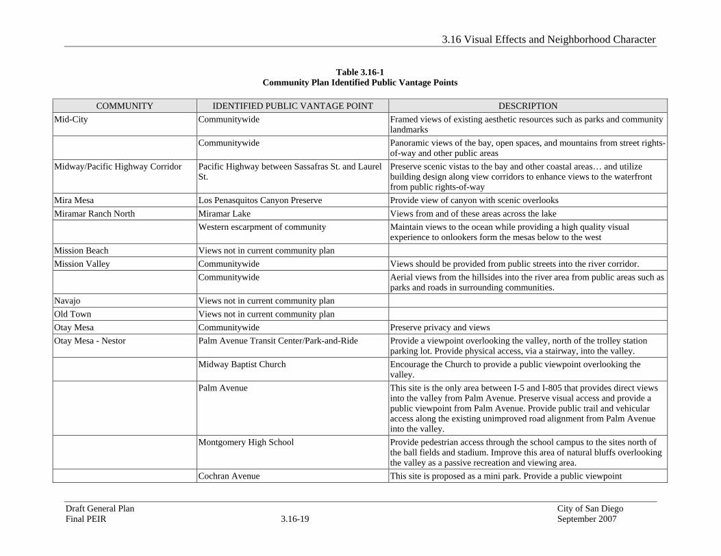
Table 3.16-1
Community Plan Identified Public Vantage Points
COMMUNITY IDENTIFIED PUBLIC VANTAGE POINT DESCRIPTION Barrio Logan / Harbor 101 Harbor Drive Bridge over Switzer Creek Views to the San Diego Bay Chollas Creek Views to the San Diego Bay 28th St and Harbor Dr Views toward I-5, SR-15 freeway interchanges (major sculptural feature) Logan Ave Centre City skyline and major industrial waterfront features National Ave Centre City skyline and major industrial waterfront features Northern portion of community Centre City skyline and major industrial waterfront features Black Mountain Ranch Northern portion of community Views overlooking the canyon and open space Carmel Mountain Ranch I-15 Views into the southern portion of the community Communitywide Views facing outside the community from open space areas in the south
central portion of the community Carmel Valley Views not in current community plan Clairemont Mesa Designated open spaces west of Clairemont Drive Views facing west to Mission Bay and Pacific Ocean Communitywide Many neighborhoods along the mesa overlook Mission Bay and the Pacific
Ocean to the west, Fortuna Mountain and Cowles Mountain to the east and the open space canyon system
College Area Views not in current community plan Del Mar Mesa Views not in current community plan Elliott Views not in current community plan Fairbanks Ranch Country Club Views not in current community plan Golden Hill Citywide Structures should be designed to protect views of Golden Hill's natural
scenic amenities, especially San Diego Bay, the Coronado Bay Bridge, Balboa Park, Switzer Canyon and the 32nd Street and 34th Street canyons
Greater North Park Views not in current community plan Kearny Mesa I-805, SR 52 & I-15 Create attractive views toward the community
La Jolla Torrey Pines City Park Viewshed overlooking coast La Jolla Farms Road Scenic Overlook and Intermittent or Partial Vista looking west towards the
coast La Jolla Scripps Natural Reserve Viewshed overlooking coast

3.16 Visual Effects and Neighborhood Character
Draft General Plan City of San Diego Final PEIR 3.16-15 September 2007
Table 3.16-1 Community Plan Identified Public Vantage Points
COMMUNITY IDENTIFIED PUBLIC VANTAGE POINT DESCRIPTION
Bluff - top easement at La Jolla Shores Lane View Cone overlooking coast Ellentown Road Scenic Overlook looking west towards the coast La Jolla Shores Drive from Torrey Pines Road Intermittent or Partial Vista looking west towards the coast La Jolla Shores Drive looking south from the
vicinity of Scripps Institute of Oceanography Viewshed overlooking coast, Scenic Overlook, Intermittent or Partial Vista, and a road from which coastal body of water can be seen
Allen Field Viewshed looking west towards the coast Bordeaux Ave (western half) Scenic Overlook looking west towards the coast El Paseo Grande (after it turns east) View corridor and a road from which coastal body of water can be seen. Camino del Oro (after it turns east) Road from which coastal body of water can be seen Whale Watch Way Intermittent or Partial Vista looking west towards the coast Cliffridge Park Viewshed looking west towards the coast Kellogg Park Viewshed overlooking coast and beach Calle Frescota View corridor looking west towards the coast Prestwick Drive Intermittent or Partial Vista looking west towards the coast Vallecitos View corridor looking west towards the coast Avenida de la Playa View corridor looking west towards the coast Calle del Cielo Views looking west towards coast Pottery Canyon Park Scenic Overlook looking west towards the coast Costabelle Drive Scenic Overlook looking west towards the coast Spindrift Drive (south of the Marine Room
Restaurant) Viewshed looking west towards coast
Charlotte Park (at the foot of Charlotte Street) View Cone and View Corridor overlooking coast Coast Blvd, Children's Pool, Shell Beach, Ellen B.
Scripps Park and La Jolla Cove Viewshed along coast looking north, east and west
Prospect St and Cave St View Cone and View Corridor overlooking coast Coast Walk View Cone overlooking coast Park Row (north end) View Corridor looking north towards the coast Torrey Pines Road Road from which coastal body of water can be seen looking north towards

3.16 Visual Effects and Neighborhood Character
Draft General Plan City of San Diego Final PEIR 3.16-16 September 2007
Table 3.16-1 Community Plan Identified Public Vantage Points
COMMUNITY IDENTIFIED PUBLIC VANTAGE POINT DESCRIPTION
the coast Public open space on Torrey Pines Rd between St.
Louis Terrace and Calle de la Plata Intermittent or Partial Vista looking north towards the coast
La Jolla Azure Coast Drive Views looking west towards coast Hidden Valley Road Intermittent or Partial Vista looking west towards the coast Ardath Road Road from which coastal body of water can be seen looking west towards
the coast Girard Avenue Scenic Overlook northwest towards the coast Jenner Street View Corridor looking northwest towards the coast View corridor easement through 7963 Prospect
Place to ocean Scenic Overlook west towards the coast
Easement across from John Coal Book Store from Prospect St and Recreation Center
Scenic Overlook west towards the coast
Hillside Drive (portions) Scenic Overlook west towards the coast Caminito Avola/Via Avola View Cone looking north, east and west towards the coast Via Siena at Hillside Drive View Cone looking north, east and west towards the coast Rue Denise Scenic Overlook northwest towards the coast La Jolla Scenic Drive South (portions) Scenic Overlook northwest towards the coast Mt. Soledad (north of Ardath Rd) View Cone looking east towards canyons Rue Adriane Scenic Overlook towards the coast Rue Michael Scenic Overlook towards the coast Senn Way Scenic Overlook towards the coast Rue de Roark Scenic Overlook towards the coast Coast Blvd. Park and South Coast Blvd Viewshed south and west along the coast View corridor at southwest side of Scripps Hotel
site, from Prospect Street View corridor west towards the coast
La Jolla Community Center Park, Cuvier Street View Cone looking west towards the coast From top of Cuvier Street at Prospect View corridor northwest towards the coast Via Capri (portions) Scenic Overlook towards the coast
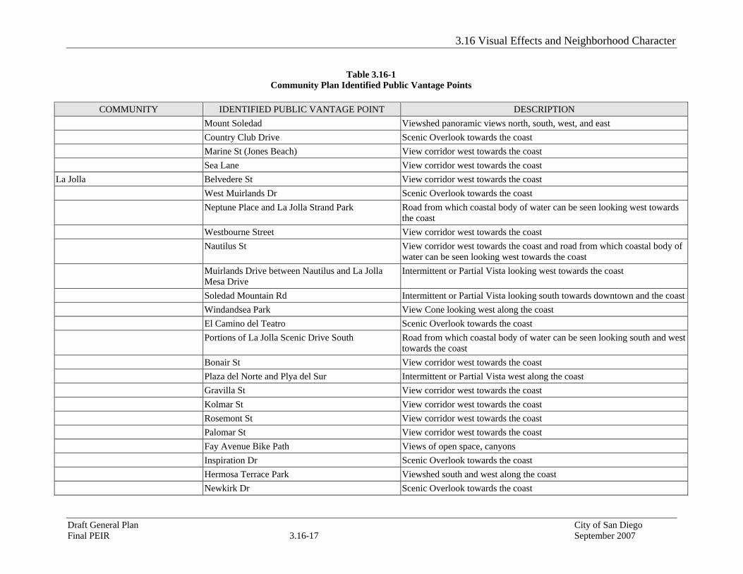
3.16 Visual Effects and Neighborhood Character
Draft General Plan City of San Diego Final PEIR 3.16-17 September 2007
Table 3.16-1 Community Plan Identified Public Vantage Points
COMMUNITY IDENTIFIED PUBLIC VANTAGE POINT DESCRIPTION
Mount Soledad Viewshed panoramic views north, south, west, and east Country Club Drive Scenic Overlook towards the coast Marine St (Jones Beach) View corridor west towards the coast Sea Lane View corridor west towards the coast La Jolla Belvedere St View corridor west towards the coast West Muirlands Dr Scenic Overlook towards the coast Neptune Place and La Jolla Strand Park Road from which coastal body of water can be seen looking west towards
the coast Westbourne Street View corridor west towards the coast Nautilus St View corridor west towards the coast and road from which coastal body of
water can be seen looking west towards the coast Muirlands Drive between Nautilus and La Jolla
Mesa Drive Intermittent or Partial Vista looking west towards the coast
Soledad Mountain Rd Intermittent or Partial Vista looking south towards downtown and the coast Windandsea Park View Cone looking west along the coast El Camino del Teatro Scenic Overlook towards the coast Portions of La Jolla Scenic Drive South Road from which coastal body of water can be seen looking south and west
towards the coast Bonair St View corridor west towards the coast Plaza del Norte and Plya del Sur Intermittent or Partial Vista west along the coast Gravilla St View corridor west towards the coast Kolmar St View corridor west towards the coast Rosemont St View corridor west towards the coast Palomar St View corridor west towards the coast Fay Avenue Bike Path Views of open space, canyons Inspiration Dr Scenic Overlook towards the coast Hermosa Terrace Park Viewshed south and west along the coast Newkirk Dr Scenic Overlook towards the coast

3.16 Visual Effects and Neighborhood Character
Draft General Plan City of San Diego Final PEIR 3.16-18 September 2007
Table 3.16-1 Community Plan Identified Public Vantage Points
COMMUNITY IDENTIFIED PUBLIC VANTAGE POINT DESCRIPTION
Rodeo Dr Scenic Overlook towards the coast Via Espana Scenic Overlook towards the coast Camino de la Costa (includes Cortez Place, Costa
Place) Viewshed south and west along the coast
Desert View Dr Intermittent or Partial Vista towards the coast La Jolla Rancho Rd Scenic Overlook towards the coast Ravenswood Rd Intermittent or Partial Vista towards the coast La Jolla La Jolla Hermosa Park Viewshed north and west along the coast La Jolla Mesa Dr (from Cottontail Lane to Skylark
St) Road from which coastal body of water can be seen looking south and west towards the coast
Moss Lane, off Dolphin Place View Cone at the coast Bird Rock Ave View corridor west towards the coast Dolphin Place Intermittent or Partial Vista towards the coast Coral Lane View corridor west towards the coast Chelsea Place Intermittent or Partial Vista towards the coast Forward St Viewshed looking south towards the coast Midway St Viewshed looking south towards the coast Colima St (end of road closest to the ocean) Scenic Overlook towards the coast Calumet Park Viewshed south and west along the coast San Colla Street Scenic Overlook towards the coast Ricardo Place Scenic Overlook towards the coast Bandera St View corridor west towards the coast Sea Ridge Dr Intermittent or Partial Vista towards the coast Linda Way View corridor south towards the coast Tourmaline Surfing Park View corridor and view cone west towards the coast La Canada Canyon Viewshed west towards the coast Princess St View Cone north overlooking the coast Linda Vista Tecolote Canyon Protect public views from the canyon
3.16 Visual Effects and Neighborhood Character
Draft General Plan City of San Diego Final PEIR 3.16-19 September 2007
Table 3.16-1 Community Plan Identified Public Vantage Points
COMMUNITY IDENTIFIED PUBLIC VANTAGE POINT DESCRIPTION
Mid-City Communitywide Framed views of existing aesthetic resources such as parks and community landmarks
Communitywide Panoramic views of the bay, open spaces, and mountains from street rights-of-way and other public areas
Midway/Pacific Highway Corridor Pacific Highway between Sassafras St. and Laurel St.
Preserve scenic vistas to the bay and other coastal areas… and utilize building design along view corridors to enhance views to the waterfront from public rights-of-way
Mira Mesa Los Penasquitos Canyon Preserve Provide view of canyon with scenic overlooks Miramar Ranch North Miramar Lake Views from and of these areas across the lake Western escarpment of community Maintain views to the ocean while providing a high quality visual
experience to onlookers form the mesas below to the west Mission Beach Views not in current community plan Mission Valley Communitywide Views should be provided from public streets into the river corridor. Communitywide Aerial views from the hillsides into the river area from public areas such as
parks and roads in surrounding communities. Navajo Views not in current community plan Old Town Views not in current community plan Otay Mesa Communitywide Preserve privacy and views Otay Mesa - Nestor Palm Avenue Transit Center/Park-and-Ride Provide a viewpoint overlooking the valley, north of the trolley station
parking lot. Provide physical access, via a stairway, into the valley. Midway Baptist Church Encourage the Church to provide a public viewpoint overlooking the
valley. Palm Avenue This site is the only area between I-5 and I-805 that provides direct views
into the valley from Palm Avenue. Preserve visual access and provide a public viewpoint from Palm Avenue. Provide public trail and vehicular access along the existing unimproved road alignment from Palm Avenue into the valley.
Montgomery High School Provide pedestrian access through the school campus to the sites north of the ball fields and stadium. Improve this area of natural bluffs overlooking the valley as a passive recreation and viewing area.
Cochran Avenue This site is proposed as a mini park. Provide a public viewpoint

3.16 Visual Effects and Neighborhood Character
Draft General Plan City of San Diego Final PEIR 3.16-20 September 2007
Table 3.16-1 Community Plan Identified Public Vantage Points
COMMUNITY IDENTIFIED PUBLIC VANTAGE POINT DESCRIPTION
overlooking the valley, including landscaping and seating. Design of this area should prevent vehicular access north of Lindberg Street, and should discourage and prevent trash dumping over the cliff.
Finney Elementary School Provide pedestrian access through the school campus to the north of the ball field and playground. Improve this area of natural bluffs overlooking the valley and finger canyons as a passive viewing area.
Murrieta Circle An existing utility easement road provides access from Murrieta Circle down to the valley. Work with SDG&E to provide public access to this trailhead and viewpoint overlooking the valley.
Servando Avenue Provide viewpoints along the alignments of Valentino Street and Bluehaven Court by clearing non-sensitve vegetation along the south side of this street, adjacent to the Tijuana River Valley. The viewpoints will provide aesthetic enjoyment for local residents and assist the U.S. Border Patrol in their operations.
Pacific Beach Loring St. View corridor facing west toward the ocean Law St. View corridor facing west toward the ocean Chalcedony St. View corridor facing west toward the ocean Missouri St. View corridor facing west toward the ocean Diamond St. View corridor facing west toward the ocean Emerald St. View corridor facing west toward the ocean Felspar St. View corridor facing west toward the ocean Mission Blvd Intermittent public view of the ocean Pacific Beach Bayard St (south) Intermittent public view of the ocean Pacific Beach Dr. Intermittent public view of the Sail Bay Lamont St. View facing south to Mission Bay Grand Ave (west and central portion community) Intermittent public view of the ocean and bay I-5 (southern portion of the community) View facing south to Mission Bay Riviera to Crown Point Dr. Views of the bay Pacific Highlands Ranch Gonzales Canyon and east-west urban amenity Open space overlook Near elementary school/park overlooking Overlooking McGonigle Canyon

3.16 Visual Effects and Neighborhood Character
Draft General Plan City of San Diego Final PEIR 3.16-21 September 2007
Table 3.16-1 Community Plan Identified Public Vantage Points
COMMUNITY IDENTIFIED PUBLIC VANTAGE POINT DESCRIPTION
McGonigle Canyon South terminus of eastern neighborhood parkway Open space overlook Community-wide Utilize public view opportunities on the edge of the MHPA Peninsula Catalina Blvd (southern portion) Coastal vistas facing east and west Shelter Island Dr Bay and downtown view facing north, west and south Rosecrans Facing southeast Talbot Facing east toward the San Diego Bay Canon Facing southeast toward the San Diego Bay Garrison Facing southeast toward the San Diego Bay Chatsworth Facing northeast West Point Loma Blvd Facing south/southeast Famosa Blvd Facing south Santa Barbara Facing nortwest toward the coast Point Loma Ave Facing northwest toward the coast Sunset Cliffs Blvd Coastal vistas facing west Sunset Cliffs Shoreline Park Unobstructed ocean view Former NTC site Southeastern view corridors from Womble Street to Sims Rd Rancho Bernardo Views not in current community plan Rancho Penasquitos Communitywide Public access to canyon rims and views should be provided at suitable
locations in the form of paths, scenic overlooks and streets Communitywide Encourage retention of wildlife habitat value in connected open space
systems by providing visual access where possible by overlooks Sabre Springs Four viewpoints and passive areas along Chicarita
Creek and Penasquitos Creek
San Pasqual Valley Views not in current community plan San Ysidro Views not in current community plan Scripps Miramar Ranch Miramar Reservoir Public viewpoints overlooking the reservoir Pomerado Road Overlooking Carroll Canyon

3.16 Visual Effects and Neighborhood Character
Draft General Plan City of San Diego Final PEIR 3.16-22 September 2007
Table 3.16-1 Community Plan Identified Public Vantage Points
COMMUNITY IDENTIFIED PUBLIC VANTAGE POINT DESCRIPTION
SDG&E Easement (Area "E") View toward open space Serra Mesa Views not in current community plan Skyline - Paradise Hills Communitywide Views of undeveloped hillsides, canyons, and mountains toward the east,
should be protected Sorrento Hills Views not in current community plan Southeast Communitywide Care should be taken to maintain and enhance views to designated open
space areas from public rights-of-way. These views should be considered in the review of discretionary permits.
Tierrasanta Communitywide Public views toward open space including Mission Trails Regional Park and Admiral Baker Field.
Tijuana River Valley Views not in current community plan Torrey Highlands Views not in current community plan Torrey Pines Views not in current community plan University Communitywide Visual access to open space areas from public roadways Uptown Adams Ave at Campus Ave Viewshed facing northwest 10th Ave and Johnson Ave Viewshed facing north/northeast Northern edge of 3rd Ave Viewshed overlooking Mission Valley Northern edge of Stephens St. at West Arbor Dr Viewshed facing north toward Mission Valley Pringle St at Neale St Viewshed facing southwest Laurel St at 1st Viewshed facing west Via de la Valle San Andres Dr and Via Campestre View facing north overlooking golf course West of San Andres Dr and East of Highland Dr View facing southeast South of San Andres Dr and North of Via de la
Valle Views facing south
3.16 Visual Effects and Neighborhood Character
Draft General Plan City of San Diego Final PEIR 3.16-23 September 2007
Notes and References Centre City Development Corporation. 2004 Implementation Plans for the Period July 2004 – June 2009 For the Centre City
and Horton Plaza Redevelopment Projects. June 15, 2004. City of San Diego 2002 Strategic Framework Element Final Environmental Impact Report. June 14, 2002.