3, responses to the niigata torrential rain disaster
TRANSCRIPT

Flood Management in Japan
1 Comprehensive Flood Control Measures1. Comprehensive Flood Control Measures
2. Provision of River information
3. Responses to the Niigata Torrential Rain Disaster
4. About ICHARM
5. Responses to 2011 Thailand Floods
6. Outline of the Tsunami-Resilient City
41

2004 Niigata Torrential Rain DisasterJuly 2004 torrential rain caused inundation in large areas resulting in extensive damagesJuly 2004 torrential rain caused inundation in large areas, resulting in extensive damages(Fatalities were 15 and approx. 21,000 buildings were damaged in Niigata prefecture※).
Inundation caused by Ikarashi River levee failure(Sanjo City Niigata Prefecture)
※: Niigata Disaster Management Office (March 23, 2005)
(Sanjo City, Niigata Prefecture)
4242

Damages caused by 2004 Niigata Torrential Rain DisasterInundation caused by Ikarashi River levee failure (Sanjo City, Niigata).y ( j y g )
Inundation due to Kariyata River levee failure(Mitsuke City, Niigata)
Inundation due to Kariyata River levee failure (Nakanoshima Town, Niigata)
43

River Improvements in consideration of 2004 DisasterMeasures in consideration of 2004 torrential rain
ExcavationRiver improvements were implemented in consideration of July 2004 flood.
Shinano River(L=34.2km)(2004 – 2009)Ikarashi River(L=3.9km) (2004 – 2010)
ExcavationEmbankment
Downstream of Shinano River Shimohachimai District
Ikarashi River Tokiwa Bridge
( ) ( )Kariyata River (L=24.5km)(2004 – 2010)
Kariyata River Nakanoshima Bridge
Shinano RiverShinano River
(September 2008) (August 2005) (June 2009)
Shinano River
Levee Improvement Widening & Excavation(March 2009) (December 2010) (December 2010)
River Channel & Levee Improvement 44

Raising Public Awareness by Disseminating “Easy to Understand” Disaster Prevention Information such as Hazard Maps
Measures in consideration of 2004 torrential rain
pList of evacuation shelters
“Easy to“Easy to understand” flood depth indication
45Hazard Map - Sanjo City Torrential Rain Disaster Handbook -

On-Site Display of Past Inundation Levels(Marugoto-Machigoto Hazard Map)
Measures in consideration of 2004 torrential rain
(Marugoto Machigoto Hazard Map)
ClosestClosest evacuation shelter
Maximum inundation depth pexpected at the location
46

Provision of Evacuation Information using Mobile Phone“Area Mail”
Measures in consideration of 2004 torrential rain
Early Warning “Area Mail”Provides disaster information such as Earthquake Early Warnings issued by the Japan Meteorological Agency and disaster and evacuation information issued by national and regional p blic instit tions to s bscribers in afflicted areasnational and regional public institutions to subscribers in afflicted areas.
Each base station simultaneously transmit mail to all users in the coverage area. Information can be received without the impact of line congestion as it uses cell broadcast service (CBS).
Simultaneously sent to areas with potential risk of disasters
• A pop-up window appear on the screen.
• Earthquake Early
Japan Meteorological AgencyEarthquake Early Warnings
Warnings and Disaster/Evacuation Information are informed by different ringing tone.
• Saved in the receive mailSaved in the receive mail box with a special icon.
Area Mail Center
47NTTdocomo HP
National and regional public institutionsDisaster and evacuation information

Distribution of “Emergency Announcement FM Radio”Measures in consideration of 2004 torrential rain
Emergency Announcement FM RadioIt can be automatically switched on/off by central control (community broadcast or public administration) and can make announcements withbroadcast or public administration) and can make announcements with high volume. It is equipped with rechargeable batteries, and receive broadcasts even during power-outage.
48

Disaster Prevention Training in consideration of 2004 DisasterMeasures in consideration of 2004 torrential rain
【Comprehensive Disaster Prevention Training】Sanjo City is conducting a comprehensive disaster prevention training every year
in June, lead by the fire department. All community firefighters in Sanjo City participate and visit homes of those people with special needsparticipate and visit homes of those people with special needs.
【Community Disaster Prevention Drills】L l iti ithi S j Cit d t th i ti d ill ith thLocal communities within Sanjo City conduct their own evacuation drills with the
firefighters.
【Voluntary Disaster Prevention Organizations】40 to 50 voluntary disaster prevention organizations were established after the
2004 flood disaster.2004 flood disaster.
49Photos:May 2010 Shinaogawa-Karyu Water Disaster Drills

Establishment of Standards for Evacuation OrdersIn order to promote smooth e ac ation actions reference to ater le els for
Measures in consideration of 2004 torrential rain
In order to promote smooth evacuation actions reference to water levels for evacuation orders have been established and categorization of water levels based on risk levels have been implemented.
Risk level
Level
5 Flooding occurs
Water Level and Risk Level Top of Levee
River
5Level
4
Flooding occurs Flooding nearly occurs
Levee
HousesRiverLevel
3
Level
Evacuation should be decided Flood is cautionary Levee
2y
Flood fighters act
Flood fighters stand byFlood Channel
Low Flow Channel
Level
1Flood fighters stand by
50
Channel
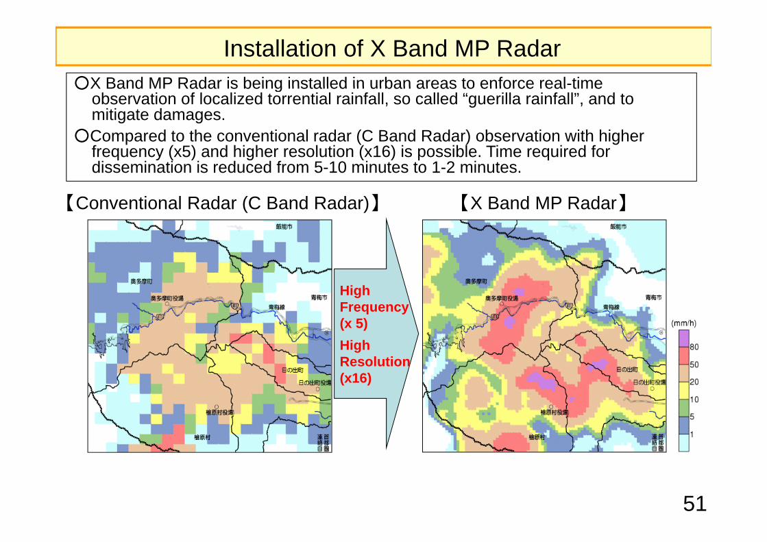
○X Band MP Radar is being installed in urban areas to enforce real-time
参考資料Installation of X Band MP Radar○X Band MP Radar is being installed in urban areas to enforce real time
observation of localized torrential rainfall, so called “guerilla rainfall”, and to mitigate damages.
○Compared to the conventional radar (C Band Radar) observation with higher f ( 5) d hi h l ti ( 16) i ibl Ti i d ffrequency (x5) and higher resolution (x16) is possible. Time required for dissemination is reduced from 5-10 minutes to 1-2 minutes.
【Conventional Radar (C Band Radar)】 【X Band MP Radar】【 ( )】 【 】
High Frequency (x 5)High Resolution (x16)
51

Precipitation Information by X Band MP Radar○X Band Radar enables higher resolution observation (250m grid)due to○X Band Radar enables higher resolution observation (250m grid)due to
shorter wave length.
【C Band Radar (longer wave length) 】 【X Band Radar (shorter wave length) 】
○ MP (Multi Parameter) Radar captures the configuration of rain drops and
Enable observation of long distance
Detailed observation is possible but with smaller observation range
○ MP (Multi-Parameter) Radar captures the configuration of rain drops and accurately estimate precipitation amount, and does not require correction using ground gauges. ⇒ Information can be disseminated with almost no lag time.
【Changing configuration of rain drops】【Multi Parameter Radar】Vertically
polarized wave
Horizontally
52
ypolarized wave
By transmitting two types of waves (vertical and horizontal) the configuration of rain drops can be captured.

Improvement of flood prevention facilities and enhancement of warning/evacuation procedures lead to reduction of damages
○ In July 2011 the Shinano River Basin in Niigata experienced a torrential rainfall of○ In July 2011 the Shinano River Basin in Niigata experienced a torrential rainfall of approx. 1,000mm (cumulative rainfall), the largest rainfall in the recorded history.
○ Total rainfall was 1.6 times more than that of July 2004 but both damages to buildings and human casualties were reduced dramatically.
Total Rainfall 1) Building Damages 2) Number of fatalities or missing 3)
1 6 timesTotal
rainfall9,778
buildings 90%
1.6 times
90%1,006mm
buildings 90% reduction 12
persons
90% reduction
Total rainfall
421 buildings 1 person
rainfall647mm
53
2004.7 2011.7 2004.7 2011.7 2004.7 2011.71)Kasabori rain gauge station2)2004.7: 7.13 Rainfall and Flood Damage Report in Niigata (March 2006 Niigata Prefecture)2011.7: Produced by Niigata Prefecture based on “First Niigata and Fukushima Rain Disaster Management Research Committee (Jul. 2011)”
3)Shinano River Downstream, Ikarashi River, Kariyata River Disaster Rehabilitation Emergency Project Pamphlet (Shinano Karyu River Office, Niigata Prefecture)