2nd caa-gr conference 20-21 december 2016 athens · 2nd caa-gr conference 20-21 december 2016...
TRANSCRIPT

2nd CAA-GR
conference
20-21 December 2016
Athens
National and Kapodistrian
University of Athens
Main Building, 30 Panepistimiou St.
Alkis Argyriadis” Amphitheatre “

1
Contents
2nd CAA-GR Conference .................................................................................................................................. 3
Conference Programme ...................................................................................................................................... 5
Abstracts ............................................................................................................................................................. 7
Tuesday, 21 December 2016 .............................................................................................................................. 7
Session 1: Field prospection and recording methods for excavation and laboratory work ..................................... 7
Session 2: Geomatics, GIS, aerial photography and remote sensing ............................................................. 9
Session 3: Data modeling, management and integration, Linked data and the semantic web ............................... 11
Session 4: Users and interfaces: education, museums and multimedia ........................................................ 12
Tuesday, 21 December 2016 ............................................................................................................................ 14
Session 5: 3D modeling, virtual reality and simulations - Part I .................................................................. 14
Session 6: 3D modeling, virtual reality and simulations - Part II ................................................................. 16
Session 7: Linked data and the semantic web .............................................................................................. 18
Session 8: Digital Cities, cultural heritage management and protection ...................................................... 19
Poster session ............................................................................................................................................... 20
CAA Constitution ............................................................................................................................................. 23
Notes ................................................................................................................................................................. 25
2
2nd
CAA-GR sponsors
Coffee breaks are organised by Mitos, a non-profit organisation for the
promotion of solidarity towards communities at risk within the framework of the
action “Coffee for a good cause” (https://mitos.org.gr/)

3
2nd CAA-GR Conference
With a history going back to 1972, CAA (Computer Applications and Quantitative Methods in Archaeology)
is the premier international conference for all aspects of computing, quantitative methods and digital
applications in Archaeology.
The Greek chapter of CAA International (CAA-GR) (http://www.caa-gr.org/) was established in 2012, in
order to develop a forum to discuss the various practical, theoretical and methodological issues involved in
the increasing number of computer applications in Greek archaeological and cultural heritage contexts, and to
share the results of related research.
The First CAA-GR conference was carried out at Rethymno by the GeoSat ReSeArch Lab of F.O.R.T.H. in
2014.
The Second CAA-GR conference features 31 presentations and 10 posters on field prospection and recording
methods for excavation and laboratory work, data modeling, management and integration, linked data and the
semantic web, 3D modeling, virtual reality and simulations, Geomatics, GIS applications, aerial photography
and remote sensing, Users and interfaces in education, museums and multimedia, Digital Cities, cultural
heritage management and protection.
Dr. Jari Pakkanen, Director of the Finnish Institute of Athens, will deliver a keynote paper on the use of
computer applications from almost as many different angles as possible in a single field project, the Kyllene
Harbour Project.
The Organizing Committee
Giorgos Vavouranakis - Assistant Prof., National & Kapodistrian University of Athens
Markos Katsianis - PhD Archaeology, Member of the CAA-GR board
Yiannis Papadatos - Assistant Prof., National & Kapodistrian University of Athens
Marlen Mouliou - Lecturer, National & Kapodistrian University of Athens
Platon Petridis - Associate Prof., National & Kapodistrian University of Athens
Support Team
Anthi Balitsari - PhD student, History and Archaeology, National & Kapodistrian Uni. of Athens
Panagiotis Michalopoulos - PhD student, History & Archaeology, National & Kapodistrian Uni. of Athens
Angelos Hliaoutakis - PhD student, Intelligent Systems Laboratory, Technical University of Crete
Katerina Glaraki - PhD student, History & Archaeology, National & Kapodistrian Uni. of Athens
Christina Mageiria - Graduate student, Museum Studies, National & Kapodistrian Uni. of Athens
Clairi Gianniri - Graduate student, Museum Studies, National & Kapodistrian Uni. of Athens
Maria Malichoutsaki - Graduate student, Museum Studies, National & Kapodistrian Uni. of Athens
Eleni Relli - Graduate student, History & Archaeology, National & Kapodistrian Uni. of Athens
Andriana Argyri - Undergrad. student, History & Archaeology, National & Kapodistrian Uni. of Athens
Ariadni Gergeraki - Undergrad. student, History & Archaeology, National & Kapodistrian Uni. of Athens
Magda Giannakopoulou - Undergrad. student, History & Archaeology, National & Kapodistrian Uni. of Athens
Melina Grigoriadou - Undergrad. student, History & Archaeology, National & Kapodistrian Uni. of Athens
Ioanna Lolou - Undergrad. student, History & Archaeology, National & Kapodistrian Uni. of Athens
Demetra Mazaraki - Undergrad. student, History & Archaeology, National & Kapodistrian Uni. of Athens
Maria-Rafaela Nikelli - Undergrad. student, History & Archaeology, National & Kapodistrian Uni. of Athens
Eleutheria Theodorou - Undergrad. student, History & Archaeology, National & Kapodistrian Uni. of Athens

4
The Scientific Committee
Athos Agapiou - Department of Civil Engineering & Geomatics, Cyprus University of Technology
Tuna Kalayci - Institute for Mediterranean Studies, Foundation for Research and Technology Hellas
Andrew Bevan - Institute of Archaeology, University College London
Gianluca Cantoro - Institute for Mediterranean Studies, Foundation for Research and Technology Hellas
Angeliki Chrysanthi - Digital Humanities Research Centre, University of Chester
Despina Catapoti - Department of Cultural Technology and Communication, University of the Aegean
Sylviane Déderix - University of Arizona
Jamieson Donati - Institute for Mediterranean Studies, Foundation for Research and Technology Hellas
Emeri Farinetti - University of Leiden
Simon Jusseret - Department of Anthropology, University of Texas at Austin
Markos Katsianis - PhD Archaeology, Member of the CAA-GR board
Anestis Koutsoudis - Cultural and Educational Technology Institute, Research Centre 'Athena'
Undine Lieberwirth - Excellence Cluster-TOPOI, Free University Berlin
Hubert Mara - Center for Scientific Computing (IWR), Heidelberg University
Marlen Mouliou - Faculty of History and Archaeology, National and KapodistrianUniversity of Athens
Eleftheria Paliou - CoDArchLab, Institute of Archaeology, University of Cologne
Giorgos Pallis - Faculty of History and Archaeology, National and Kapodistrian University of Athens
Yiannis Papadatos - Faculty of History and Archaeology, National and Kapodistrian University of Athens
Konstantinos Papadopoulos - Maynooth University, An ForasFeasa
Nikos Papadopoulos - Institute for Mediterranean Studies, Foundation for Research and Technology Hellas
Petros Patias - School of Rural & Surveying Engineering, Aristotle University of Thessaloniki
Platon Petridis - Faculty of History and Archaeology, National and KapodistrianU niversity of Athens
Apostolos Sarris - Institute for Mediterranean Studies, Foundation for Research and Technology Hellas
Grigorios Tsokas - Laboratory of Exploration Geophysics, Aristotle University of Thessaloniki
George Vavouranakis - Faculty of History and Archaeology, National and Kapodistrian University of Athens
Athanasios Vellios - Ligatus Research Centre, University of the Arts London

5
Conference Programme
Tuesday, 20 December 2016 09.30-09.45 Opening Remarks
09.45-11.30 Session 1: Field prospection and recording methods for excavation and laboratory
work (chair: G. Vavouranakis)
09.45-10.00 Late Roman and Byzantine urbanism at a glance: results from remote sensing and
geophysical prospection at Amorium - J.C. Donati, T. Kalayci, N. Tsivikis & A. Sarris
10.00-10.15 Ποσοτικές μέθοδοι στη Διερεύνηση των επιδράσεων των περιβαλλοντικών παραγόντων στα
οργανικά υλικά τεκμήρια φυσικής και πολιτιστικής κληρονομιάς - Η περίπτωση του οστού -
Ε. Παπαγεωργίου, Δ. Καρλής, Σ. Μπογοσιάν, Ε. Καραντώνη, Α. Χριστόπουλος, Ε. Φώτου, Κ.
Βόσου & Γ. Παναγιάρης
10.15-10.30 Geophysical Imaging of the interior of tumuli to save their integrity - G.N. Tsokas, P.I.
Tsourlos & G. Vargemezis
10.30-10.45 Satellite based investigation for detection of ancient tombs' looting in Cyprus - A. Agapiou & V. Lysandrou
10.45-11.10 Q&A
11.10-11.30 Coffee break
11.30-12.55 Session 2: Geomatics, GIS, aerial photography and remote sensing (chair: J. Donati)
11.30-11.45 Species distribution models for the investigation of Neolithic sites in the Tavoliere plain
(Southern Italy) - M. Noviello, B. Cafarelli, C. Calcutti, A. Sarris & P. Mairota
11.45-12.00 Towards a GIS-based reconstruction of a coastal landscape, integrating geomorphological
and archaeological evidence - G. Alexandrakis, K. Athanasaki & A. Kampanis
12.00-12.15 Modelling the topography of the ancient Lavrion: epigraphical sources, mental maps and GIS
- E. Farinetti & A. Kapetanios
12.15-12.30 Geoinformatic approaches to assess the landform characteristics of Minoan settlements and
characterise the water management planning in Bronze Age Crete - Α. Argyriou & A. Sarris
12.30-12.55 Q&A
12.55-15.00 Lunch break
15.00-16.00 Session 3: Data modeling, management and integration, Linked data and the semantic
web (chair: M. Katsianis)
15.00-15.15 Μεθοδολογία μοντελοποίησης ανασκαφικής διαδικασίας με σωζόμενα αρχιτεκτονικά
λείψανα - E. Χρηστάκη, M. Doerr & Χ. Μπεκιάρη
15.15-15.30 Μοντελοποίηση των ανασκαφικών συγκειμένων: εννοιολογική αρχιτεκτονική και
συμβατότητα στην τεκμηρίωση προϊστορικών θέσεων - Θ. Αγγελοπούλου & Γ. Βαβουρανάκης
15.30-15.45 Creating the National Archive of Monuments: an on-going adventure towards the
documentation, the digitalization and the promotion of cultural heritage – Χ. Τσέλιος
15.45-16.00 Q&A
16.00-16.20 Coffee break
16.20-17.30 Session 4: Users and interfaces: education, museums and multimedia (chair: M. Mouliou)
16.20-16.35 Brescia-Brixia (Italy). Travel across the ancient landscapes: Museum of the City and its
archaeological area between research and enhancement - F. Morandini
16.35-16.50 Design and development of the video game Secrets of the Past: Excavating the City of Zeus -
L. Mantzourani & A. Giannakidis
16.50-17.05 Εικονικό Μουσείο Μέγας Αλέξανδρος: από τις Αιγές στην οικουμένη - Y. Aspiotis, B.
Mitsiopoulos & H. Sidiropoulos
17.05-17.20 Διαδικτυακές εφαρμογές για το νεανικό κοινό. Ένα παράδειγμα του e-Βυζαντινού και
Χριστιανικού Μουσείου - Π. Βοσνίδης
17.20-17.40 Q&A
17.40-18.00 Coffee break
18.00-19.00 Keynote: Kyllene Harbour Project: from survey to analysis - J. Pakannen
6
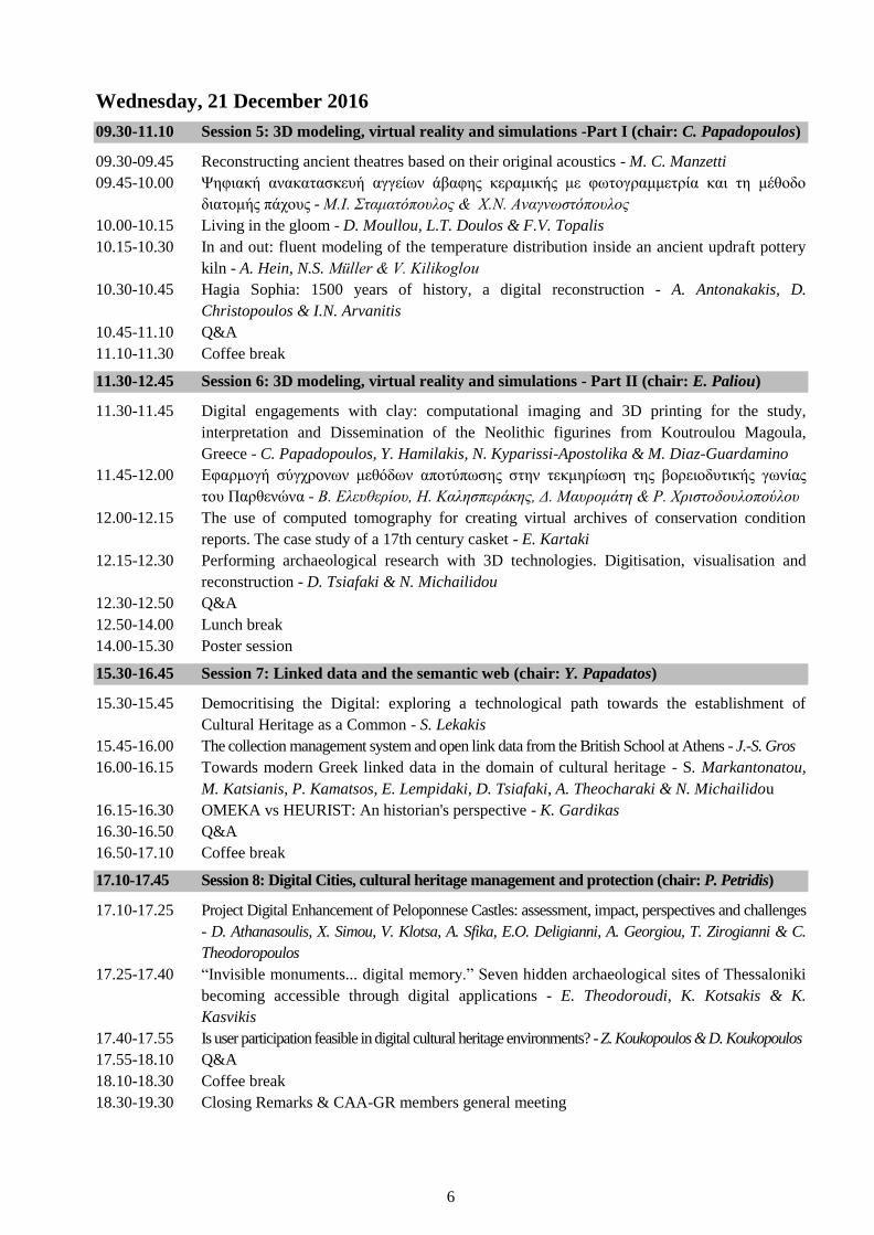
Wednesday, 21 December 2016
09.30-11.10 Session 5: 3D modeling, virtual reality and simulations -Part I (chair: C. Papadopoulos)
09.30-09.45 Reconstructing ancient theatres based on their original acoustics - M. C. Manzetti
09.45-10.00 Ψηφιακή ανακατασκευή αγγείων άβαφης κεραμικής με φωτογραμμετρία και τη μέθοδο
διατομής πάχους - Μ.Ι. Σταματόπουλος & Χ.Ν. Αναγνωστόπουλος
10.00-10.15 Living in the gloom - D. Moullou, L.T. Doulos & F.V. Topalis
10.15-10.30 In and out: fluent modeling of the temperature distribution inside an ancient updraft pottery
kiln - A. Hein, N.S. Müller & V. Kilikoglou
10.30-10.45 Hagia Sophia: 1500 years of history, a digital reconstruction - A. Antonakakis, D.
Christopoulos & I.N. Arvanitis
10.45-11.10 Q&A
11.10-11.30 Coffee break
11.30-12.45 Session 6: 3D modeling, virtual reality and simulations - Part II (chair: E. Paliou)
11.30-11.45 Digital engagements with clay: computational imaging and 3D printing for the study,
interpretation and Dissemination of the Neolithic figurines from Koutroulou Magoula,
Greece - C. Papadopoulos, Y. Hamilakis, N. Kyparissi-Apostolika & M. Diaz-Guardamino
11.45-12.00 Εφαρμογή σύγχρονων μεθόδων αποτύπωσης στην τεκμηρίωση της βορειοδυτικής γωνίας
του Παρθενώνα - Β. Ελευθερίου, Η. Καλησπεράκης, Δ. Μαυρομάτη & Ρ. Χριστοδουλοπούλου
12.00-12.15 The use of computed tomography for creating virtual archives of conservation condition
reports. The case study of a 17th century casket - E. Kartaki
12.15-12.30 Performing archaeological research with 3D technologies. Digitisation, visualisation and
reconstruction - D. Tsiafaki & N. Michailidou
12.30-12.50 Q&A
12.50-14.00 Lunch break
14.00-15.30 Poster session
15.30-16.45 Session 7: Linked data and the semantic web (chair: Y. Papadatos)
15.30-15.45 Democritising the Digital: exploring a technological path towards the establishment of
Cultural Heritage as a Common - S. Lekakis
15.45-16.00 The collection management system and open link data from the British School at Athens - J.-S. Gros
16.00-16.15 Towards modern Greek linked data in the domain of cultural heritage - S. Markantonatou,
M. Katsianis, P. Kamatsos, E. Lempidaki, D. Tsiafaki, A. Theocharaki & N. Michailidou
16.15-16.30 OMEKA vs HEURIST: An historian's perspective - K. Gardikas
16.30-16.50 Q&A
16.50-17.10 Coffee break
17.10-17.45 Session 8: Digital Cities, cultural heritage management and protection (chair: P. Petridis)
17.10-17.25 Project Digital Enhancement of Peloponnese Castles: assessment, impact, perspectives and challenges
- D. Athanasoulis, X. Simou, V. Klotsa, A. Sfika, E.O. Deligianni, A. Georgiou, T. Zirogianni & C.
Theodoropoulos
17.25-17.40 “Invisible monuments... digital memory.” Seven hidden archaeological sites of Thessaloniki
becoming accessible through digital applications - E. Theodoroudi, K. Kotsakis & K.
Kasvikis
17.40-17.55 Is user participation feasible in digital cultural heritage environments? - Z. Koukopoulos & D. Koukopoulos
17.55-18.10 Q&A
18.10-18.30 Coffee break
18.30-19.30 Closing Remarks & CAA-GR members general meeting

7
Abstracts
Tuesday, 21 December 2016
Session 1: Field prospection and recording methods for excavation and laboratory work
Late Roman and Byzantine urbanism at a glance: results from remote sensing and geophysical
prospection at Amorium, J.C. Donati, T. Kalayci, N. Tsivikis & A. Sarris
Keywords: Amorium, Urbanism, Satellite Remote Sensing, Geomagnetic Prospection
Amorium was a Greek and Roman settlement in Anatolia that also flourished as a Byzantine center between
the seventh and eleventh centuries CE. As such, the city offers unique opportunities for understanding aspects
of Late Roman and Byzantine urbanism. Satellite and airborne remote sensing was used to study the urban
environment and its wider rural setting. Image enhancement techniques allowed the identification of surface
anomalies that relate to buried architecture, including extensive fortification walls. In the countryside,
patterns were recognised in the directional alignments of modern field boundaries, which, in many cases,
share the orientation of buildings at Amorium. Further evidence of the urban characteristics of Amorium
comes from a geomagnetic survey. The results provide information on buildings and road systems. In total,
remote sensing and geophysics provide valuable insights related to the site’s urban morphology and offer
tentative reconstructions, filling an important gap in Byzantine archaeology.
Ποσοτικές μέθοδοι στη διερεύνηση των επιδράσεων των περιβαλλοντικών παραγόντων στα οργανικά
υλικά τεκμήρια φυσικής και πολιτιστικής κληρονομιάς - Η περίπτωση του οστού, Ε. Παπαγεωργίου, Δ.
Καρλής, Σ. Μπογοσιάν, Ε. Καραντώνη, Α. Χριστόπουλος, Ε. Φώτου, Κ. Βόσου & Γ. Παναγιάρης
Λέξεις-κλειδιά: Οργανικά υλικά, Οστό, Παράγοντες γήρανσης, Ρυπαντές, Φυσική και πολιτιστική
κληρονομιά, ANOVA, Fractional factorial design
Στην παρούσα εργασία, παρουσιάζεται η έρευνα της επίδρασης διαφόρων παραγόντων γήρανσης στις
φυσικές και χημικές ιδιότητες οστέινων αντικειμένων πολιτιστικής κληρονομιάς. Πραγματοποιήθηκαν
μετρήσεις σε μια πλειάδα από χαρακτηριστικά ενδιαφέροντος όπως το χρώμα, οι μηχανικές ιδιότητες, η
στιλπνότητα, η δομή και οι χημικές ιδιότητες. Εξετάστηκαν παράγοντες με 2 επίπεδα ο καθένας: υγρασία,
χρόνος έκθεσης, επίδραση των NOx και SOx καθώς και η σειρά με την οποία οι δυο παραπάνω ρυπαντές
επέδρασαν. Το πείραμα βασίστηκε σε ένα 24 fractional factorial design λόγω περιορισμών κόστους και
χρόνου. Εφαρμόζοντας ANOVA συμπεράναμε ότι στατιστικά σημαντικοί παράγοντες για το χρώμα ήταν τα
είδη των ρυπαντών, για τις μηχανικές ιδιότητες και τη σκληρότητα ήταν η υγρασία ενώ η σειρά με την οποία
εφαρμόστηκαν τα NOx και SOx βρέθηκε στατιστικά σημαντική για τις ιδιότητες του χρώματος και τη
σκληρότητα των δοκιμίων.
Geophysical Imaging of the interior of tumuli to save their Integrity, G.N. Tsokas, P.I. Tsourlos & G.
Vargemezis
Keywords: Tumuli, Geophysical Investigations, ERT, Searching in Barrows
Tumuli are manmade embankments comprising funeral practice for several civilisations around the Globe.
Usually, they cover monumental tombs and other relevant structures like ‘dromoi’. If these structures have
been left intact it is much likely that they bear important findings. In many cases, the hunt for the burial
chambers and the goods concealed there lead to harming irreversibly the integrity of the monument.

8
Geophysics comprise methods that can yield images of the interior of these monuments guiding the
subsequent digging and therefore preserving as much of the embankment as possible. Resistance mapping,
resistivity soundings, magnetometry, electromagnetic and seismic methods, both conventional and
tomographic, have been used for this purpose. In the recent years, the application of electrical resistivity
tomography (ERT) proved to be very successful and reliable. This paper focuses on the relevant merits and
drawbacks of the methods employed. Their potential is demonstrated by examples in various types of tumuli.
Satellite based investigation for detection of Ancient tombs' looting in Cyprus, A. Agapiou & V.
Lysandrou
Keywords: Archaeological looting, Remote Sensing, Aerial images, Satellite Images, WorldView-2, Google
Earth©, Cyprus
This study presents the analysis of high resolution multispectral satellite and aerial images (WorldView-2)
and RGB images from Google Earth© in order to map and diachronically monitor sites of archaeological
interest that are endangered from looting. The research concerns the archaeological landscape of Ayios
Mnason in Politico village Cyprus, where more than 10 looted tombs have been identified. Some of these
tombs have been disturbed in the past, while others by more recent illegal activities, detected in depth of
more than 3 meters below ground surface. Image processing and in situ investigations evidenced that this
phenomenon is not isolated, since other areas in the western part of the case study have been disturbed.
Overall, it is evident that image analysis and processing of high resolution multispectral satellite datasets, can
be used for systematic monitoring of areas with archaeological interest, in order to protect and safeguard
cultural heritage against illegal archaeological activities.

9
Session 2: Geomatics, GIS, aerial photography and remote sensing
Species distribution models for the investigation of Neolithic sites in the Tavoliere plain (Southern
Italy), M. Noviello, B. Cafarelli, C. Calcutti, A. Sarris & P. Mairota
Keywords: Archaeology, GIS Multiparametric spatial analysis, Maximum Entropy (MaxEnt), Neolithic
Predictive Models, Remote sensing, Spatial PCA
Cultural heritage protection policies and the efficient management of archaeological risk impact inherent in
infrastructural planning require the study of the distribution of archaeological features in present landscapes.
This can benefit from the combined use of probability distribution models and remote sensing data. Two
predictive models (a GIS based multiparametric spatial analysis and MaxEnt) were compared and assessed
with an inductive approach in a well-investigated area of the Tavoliere Plain (Southern Italy) based on
presence only data. Topographic, geo-morphological and remote sensing derived environmental variables
were employed. MaxEnt model provided the best performance. Model selection (Akaike’s Information
Criterion) indicated spatial PCA as a viable means for the choice of environmental variables.
Towards a GIS-based reconstruction of a coastal landscape, integrating geomorphological and
archaeological evidence, G. Alexandrakis, K. Athanasaki & A. Kampanis
Keywords: Sea Level Changes, Landscape Reconstruction, Minoan, Heraklion, Crete
Prehistoric societies and dynamic coastal environments are entwined with each other and interact on manifold
levels. The present study aims to be a starting point for exploring the interplay between natural processes and
the social landscape of Ammoudara and to provide the geomorphological base for the reconstruction of the
cultural biography of the area. The area was examined geomorphologically and sedimentologically and a first
assessment of the environmental conditions during Neolithic and Minoan period was made. While previous
archaeological research data were also integrated and evaluated. Supported by the long-term archaeological
and geomorphological analysis, it can be assumed that the shoreline was subjected to spatiotemporal
variations while the alluvial plane sediments were appropriate for agricultural activities in contrast to the
current state of the coastal depositional environment. Furthermore, the perspective of integrating these data in
a much wider framework, as part of ongoing projects will be examined.
Modelling the topography of the ancient Lavrion: epigraphical sources, mental maps and GIS, E.
Farinetti & A. Kapetanios
Keywords: Mental Maps, GIS, Epigraphy, Lavrion Mines, Landscape
In this contribution, we will present an attempt to approach the past landscape of the Lavrion area,
considering inscriptions dated to the 4th and 3rd C BC, recording the leases of the mines by the Athenian
polity to individuals (the so-called /poletae/ record), as mental maps. The research aim is threefold: first, the
aim is to reconstruct a flexible set of abstract mental maps, beyond a defined geometric space, in order to
explore the network of spatial relationships defined in the epigraphical record and the social and economic
meanings involved; second, to develop a methodology for the production of an “intermediate” map, spatially
and geometrically correct, which transforms the mental map into an intra-referential map; third, final goal is
to proceed to a reconstruction (insofar it is possible) of the landscape and the topographical layout of the area
as in the 4th and 3rd C BC.
10
Geoinformatic approaches to assess the landform characteristics of Minoan settlements and
characterise the water management planning in Bronze Age Crete, Α. Argyriou & A. Sarris
Keywords: Bronze Age Crete, Landform Classification, Water Management, Multi-criteria Decision
Analysis, Least Cost Path Analysis
The determination of geomorphology plays an important role in archaeological landscape research. Several
landform types can be distinguished by characteristic geomorphic attributes that portray the surrounding
landscape of a settlement and evaluate its geographical importance in terms of its ability to sustain a
population. Various geoinformatic approaches are acknowledged, by using the free available ASTER G-
DEM. The locations of archaeological settlements and the characterisation of the dominant surrounding
landscape geomorphometrics can reveal insights into the development of settlements and provide a better
understanding of human behaviour, with regard the landscape characteristics over time, such as the water
management. This study aims to assess the best routes for water resources reaching the major settlements, by
using integrated Multi-Criteria Decision Analysis (MCDA) and Least-Cost Path Analysis (LCPA)
approaches in GIS. Such an approach proves to be a valuable tool for archaeologists to determine and
evaluate the water management planning in ancient periods.

11
Session 3: Data modeling, management and integration, Linked data and the semantic web
Μεθοδολογία μοντελοποίησης ανασκαφικής διαδικασίας με σωζόμενα αρχιτεκτονικά λείψανα, E.
Χρηστάκη, M. Doerr & Χ. Μπεκιάρη
Λέξεις-κλειδιά: Εννοιολογική Μοντελοποίηση, CIDOC CRM, Αρχαιολογία, Τεκμηρίωση
Τα τελευταία χρόνια η χρησιμοποίηση εννοιολογικών μοντέλων για την δημιουργία Πληροφοριακών
Συστημάτων έχει συμβάλει στην τεκμηρίωση και ενοποίηση ετερογενών και ποικίλων δεδομένων της
Πολιτιστικής Κληρονομιάς. Πληροφορίες σχετικά με μουσειακά αντικείμενα, αρχαιολογικά μνημεία, βιβλία
κλπ μπορούν να διασυνδεθούν έχοντας ως πρότυπο μια κοινή γλώσσα επικοινωνίας ανάμεσα στους ειδικούς.
Στον τομέα της Αρχαιολογίας, καινοτόμα προγράμματα και εφαρμογές, χρησιμοποιούν εννοιολογικά
μοντέλα για την τεκμηρίωση και ανάδειξη αρχαιολογικών χώρων, κτηρίων και αντικειμένων. Στην παρούσα
μελέτη προτείνεται μια μεθοδολογία μοντελοποίησης της ανασκαφικής διαδικασίας και των αρχαιολογικών
δεδομένων σε συνδυασμό με τα σωζόμενα αρχιτεκτονικά λείψανα, με σκοπό την εξαγωγή συμπερασμάτων
για την τεκμηρίωση των αρχαιολογικών κτηρίων. Η μεθοδολογία αυτή βασίζεται στο εννοιολογικό μοντέλο
αναφοράς CIDOC CRM (πρότυπο ISO 21127) για την ενοποίηση πολιτισμικών δεδομένων και τις
επεκτάσεις (CRMarchaeo, CRMba, CRMsci, CRMinf, CRMdig, CRMgeo). Ως παράδειγμα μελέτης
χρησιμοποιήθηκε ο αρχαιολογικός χώρος του Ακρωτηρίου της Θήρας, δημοσιευμένα δεδομένα και
ευρήματα του οποίου χαρτογραφήθηκαν σύμφωνα με τα παραπάνω μοντέλα.
Μοντελοποίηση των ανασκαφικών συγκειμένων: εννοιολογική αρχιτεκτονική και συμβατότητα στην
τεκμηρίωση προϊστορικών θέσεων, Θ. Αγγελοπούλου & Γ. Βαβουρανάκης
Λέξεις-κλειδιά: Συγκείμενα, Διαλειτουργικότητα, Μοντελοποίηση, Τεκμηρίωση Ανασκαφικών Δεδομένων,
Απεσωκάρι, Τσούγκιζα, Αγγελοχώρι
Η ποικιλία ανασκαφικών τεχνικών και κυρίως η ελαστική προσέγγιση της έννοιας των συγκειμένων
(context) θέτει το ζήτημα της διαλειτουργικότητας σε σχέση με τα συστήματα τεκμηρίωσης της
ανασκαφικής διαδικασίας. Η παρούσα εργασία αφορμάται από ένα παρόμοιο προβληματισμό που
δημιουργήθηκε κατά την ανάπτυξη του συστήματος τεκμηρίωσης του υλικού της σχολάζουσας ανασκαφής
του μινωικού θολωτού τάφου Ι στη θέση Απεσωκάρι Μεσαράς της Κρήτης. Η λύση που προτάθηκε δεν
περιορίζει τα συγκείμενα στη μορφή μίας ετικέτας που χαρακτηρίζει κάθε όγκο χώματος, αλλά τα αποδομεί
σε κριτήρια και ερωτήματα. Η σύνθεση των τελευταίων παράγει το εκάστοτε περιβάλλον συγκειμενικής
συνάφειας. H παρούσα προσέγγιση διαβλέπει στην ανασκαφική πρακτική την ανάγκη ανάγνωσης τόσο του
χωρόχρονου που εμπεριέχει ο εκάστοτε όγκος χώματος όσο και των διαδρομών που προκύπτουν από την
ανάλυση της πληροφορίας που ανασκάπτεται. Η εφαρμοσιμότητα του προτεινόμενου σχήματος ελέγχεται
συγκριτικά με βάση τα ανασκαφικά δεδομένα από την Τσούγκιζα Νεμέας και το Αγγελοχώρι Ημαθίας.
Creating the National Archive of Monuments: an on-going adventure towards the documentation, the
digitalization and the promotion of cultural heritage, Χ. Τσέλιος
Keywords: National Archive of Monuments (NAM)
The National Archive of Monuments (NAM) is the main tool for the protection and the management of all
listed monuments in Greece. Behind the creation of a vivid and constantly renewable archive of monuments
lies the need for the effective protection of the culture heritage. This need is met by the design and
implementation of a digital archive based on cutting edge technology. NAM’s information system is
composed of two separate but compensated sub systems: the Archaeological Cadastre is the first organised,
on-going and systematic digital registry for public assets, protection areas of cultural environment and
ancient and modern immovable monuments. The Integrated Information System (IIS) of the Digital Movable
Monuments Collection is a powerful tool for the recording and the management of movable monuments
nationwide. The ongoing updating of NAM’s infrastructures and the continuing enrichment of its collections
has become a focal point in the efforts of the Hellenic Ministry of Culture and Sports to protect and promote
Greece’s cultural heritage and to improve the services provided to the public.
12
Session 4: Users and interfaces: education, museums and multimedia
Brescia-Brixia (Italy). Travel across the ancient landscapes: Museum of the City and its archaeological
area between research and enhancement, F. Morandini
Keywords: Archaeology, Augmented reality, Virtual Reality, Enhancement, Museum, 3dimensional
Reconstruction, Heritage
For the first time in Italy, an audio guided tour with wearable technologies has been proposed in an
archaeological area; visitors can walk around, wearing special glasses, and enjoy augmented contents as
3dimensional reconstructions and videos overlapped to the current landscape. This is a studied strategy for
enhancing the ancient heritage of the Archaeological Park of the city; the realisation has been possible thanks
to excavations and researches achieved by integrated expertise. Thus the ancient landscape has been
completely studied and re-enacted, and it is put on display with excellent architectural solutions in order to
protect the ancient layers and to enhance their value. Thank to large approval expressed by visitors and
satisfaction reached by researchers, the same technology has been tested in another archaeological area inside
the Museum. This technology enables to present reconstructions avoiding interventions on monuments and it
is helpful to improve accessibility to ancient heritage.
Design and development of the video game Secrets of the Past: Excavating the City of Zeus, L.
Mantzourani & A. Giannakidis
Keywords: Educational, Video Game, Excavation, Photogrammetry, 3d, Archaeology
The potential of digital games to act as virtual learning spaces as well as dissemination tools for cultural
heritage has been well documented, yet the use of digital games in this capacity remains limited. To add a
practical dimension to the theoretical approach of the value of digital games for cultural heritage, this
presentation explores the design, development and projected use of Secrets of the Past: Excavating the City
of Zeus, a digital game that invites the young public to experience the work of archaeologists in three stages -
from the excavation, to the preservation and finally the exhibition of ancient artefacts. In an environment
inspired by the archaeological site of Dion, incorporating 3D scans of archaeological objects, the game takes
the player ‘behind the scene’, introducing the archaeological process as a prelude to the museum experience.
The implications of this game for the field of archaeology relate to the educational and dissemination
objectives of the discipline, as well as to the digitisation and (re)use of digitised archaeological material for
educational and recreational purposes.
Εικονικό Μουσείο Μέγας Αλέξανδρος: από τις Αιγές στην οικουμένη, Y. Aspiotis, B. Mitsiopoulos & H. Sidiropoulos
Λέξεις-κλειδιά: Εικονικό Μουσείο, Διαδραστικό Ντοκιμαντέρ, Ψηφιακό Storytelling, Μέγας Αλέξανδρος
Το ‘Εικονικό Μουσείο Μέγας Αλέξανδρος: από τις Αιγές στην Οικουµένη’ που θα παρουσιαστεί στο κοινό
το 2017 φιλοδοξεί να καταστεί ένα µοναδικό σηµείο αναφοράς για τους Μακεδόνες και τον ελληνιστικό
κόσµο µέσα από ενα καινοτόµο συγκερασµό ψηφιακών εργαλείων. Η πρωτοτυπία στη σύλληψη και το
σχεδιασµό του είναι οτι συνδυάζει αφηγηµατικές τεχνικές από το σύγχρονο ψηφιακό storytelling µε τις
δυνατότητες του διαδραστικού ντοκιµαντέρ. Η τοµή στην προσέγγιση της αφηγηµατικής πλοκής είναι πως
δεν είναι απαραίτητα γραµµική, επιτρέποντας την περιήγηση στο χώρο και στο χρόνο, δηµιουργώντας
δηλαδή µια ά-χρονη και α- τοπική εµπειρία. Περαιτέρω βασικά χαρακτηριστικά του διαδραστικού
ντοκιµαντέρ είναι ο αυξανόµενα ενεργός ρόλος του χρήστη καθώς και η συνδυαστική χρήση των διάφορων
µέσων όπως κείµενα, φωτογραφίες, video, 3D, animation, sound design κτλ.

13
Διαδικτυακές εφαρμογές για το νεανικό κοινό. Ένα παράδειγμα του e-Βυζαντινού και Χριστιανικού
Μουσείου, Π. Βοσνίδης
Λέξεις-κλειδιά: Ε-Βυζαντινό και Χριστιανικό Μουσείο, Εκπαίδευση, Διαδίκτυο, Εικονικό Μουσείο
Στη σημερινή πραγματικότητα, που διαρκώς μεταβάλλεται από τις εξελίξεις στον τομέα της τεχνολογίας,
πολιτιστικοί-εκπαιδευτικοί οργανισμοί σχεδιάζουν και υλοποιούν πολυδάπανα, κατά περίπτωση, έργα με
στόχο την αναβάθμιση της λειτουργίας τους σε όλα τα επίπεδα (ερευνητικό, ασφαλείας, προβολής κ.α.) Το
2012 το Βυζαντινό και Χριστιανικό Μουσείο ξεκίνησε το έργο «Ε-Βυζαντινό και Χριστιανικό Μουσείο». Το
αντικείμενο του έργου ήταν η συνολική, ψηφιακή διαχείριση των συλλογών και λειτουργιών Μουσείου και η
ανάπτυξη διαδραστικών πολιτιστικών εφαρμογών, για τη διαδικτυακή πρόσβαση στις συλλογές του
μουσείου πολλών και διαφορετικών ομάδων κοινού σε εθνικό και διεθνές επίπεδο. Παράλληλα, σχεδιάστηκε
και υλοποιήθηκε σειρά εκπαιδευτικών εφαρμογών που απευθύνονται στο νεανικό κοινό ακολουθώντας
βασικές αρχές της μάθησης. Οι συγκεκριμένες εφαρμογές έχουν αφετηρία τη μόνιμη έκθεση του Μουσείου.
Τα αντικείμενα που έχουν επιλεγεί είναι και εκθέματα που με κάθε αφορμή προβάλλουν ποικίλες
πληροφορίες μέσα από τις διασυνδέσεις τους με άλλες εφαρμογές.
14
Tuesday, 21 December 2016
Session 5: 3D modeling, virtual reality and simulations - Part I
Reconstructing ancient theatres based on their original acoustics, M. C. Manzetti
Keywords: Roman theatres, Crete, virtual acoustics analysis
It is always complex to understand and interpret something that belongs to the past, and it is even more
difficult when there are not archaeological remains or not enough evidence to describe the structure and the
time evolution of a monument or an archaeological site. Luckily, in the last years, technology enhances our
possibility to create more faithful reconstructions of the ancient world. This paper presents a new
methodology that helps to produce more accurate architectural reconstructions of monuments. The virtual
acoustics analysis of the Roman theatre of Gortyn, at Kazinedes, demonstrates how testing the acoustics’
quality of its full 3D models is essential to validate or not hypothetical reconstructions, and more generally to
correct the architectural structure of buildings where acoustics is a fundamental aspects.
Ψηφιακή ανακατασκευή αγγείων άβαφης κεραμικής με φωτογραμμετρία και τη μέθοδο διατομής
πάχους, Μ.Ι. Σταματόπουλος & Χ.Ν. Αναγνωστόπουλος
Λέξεις-κλειδιά: Διατομή πάχους, Όστρακα, 3Δ Γραφικά, Φωτογραμμετρία, Ψηφιακή ανασύνθεση,
Κεραμικά αγγεία
Η ψηφιακή ανακατασκευή ενός θραυσμένου κεραμικού αγγείου, αρχαιολογικού ενδιαφέροντος, είναι ένα
ανοικτό, σύνθετο και πολύπλευρο πρόβλημα, το οποίο εξακολουθεί να απασχολεί την παγκόσμια
επιστημονική κοινότητα. Κάθε αρχαιολογική ανασκαφή, φέρνει ταυτόχρονα στο φως, πλήθος μικρών
κεραμικών θραυσμάτων (τα λεγόμενα όστρακα), τα οποία προσφέρουν πλούσια συμπεράσματα. Η αξία
αυτών των πληροφοριών, χαρίζει δικαίως στα όστρακα, τον τίτλο, του καλύτερου διακομιστή πληροφοριών
από την αρχαία εποχή έως τις ημέρες μας. Η πλειονότητα των προτεινομένων μεθόδων για την ψηφιακή
ανακατασκευή κεραμικών αγγείων, βασίζεται στα εξωτερικά χαρακτηριστικά, τα οποία όμως επηρεάζονται
σημαντικά, στο πέρασμα των αιώνων. Η συγκεκριμένη επιστημονική εργασία, βασίζεται σε μια εντελώς νέα,
διαφορετική και πιο ασφαλή ιδέα, καθώς δεν αναζητά πληροφορίες στις εξωτερικές επιφάνειες, αλλά
χρησιμοποιεί μετρήσεις πάχους που εξακολουθούν να παραμένουν με ασφάλεια εγκιβωτισμένες στον
πυρήνα των οστράκων. Η μέθοδος, επαληθεύεται πειραματικά με τη χρήση τεχνολογιών αιχμής, σε
σύγχρονα χειροποίητα κεραμικά αγγεία καθώς και σε τμήμα πραγματικού αρχαίου αγγείου άβαφης
κεραμικής.
Living in the gloom, D. Moullou, L.T. Doulos & F.V. Topalis
Keywords: Ancient Lighting, 3D Simulation, Color Recognition, Low Lighting Levels, Photometric
Calculations
This paper aims to investigate the feasibility of indoor nocturnal activities in houses of antiquity in terms of
colour perception under the lighting conditions resulting from the use of lamps and the ability or the optical
discomfort for users when discriminating colours. A set of 3D simulations were performed in the Lighting
Laboratory of the National Technical University of Athens using different colour pallets (sets of lines and
squares with varying dimensions and spacing) in order to simulate different nocturnal tasks. The luminance
values extracted from the surface of the pallet and the corresponding parameters for colour discrimination
were calculated. According to the results there is a considerable difference between some colours while this
difference is negligible among others, meaning that, especially for weaving at night, skillful persons or
specific colours were required for discrimination to be recognizable.

15
In and out: fluent modeling of the temperature distribution inside an ancient updraft pottery kiln, A.
Hein, N.S. Müller & V. Kilikoglou
Keywords: Ceramic Kiln, 3D Model, Fluent Modeling, Temperature Distribution
In the present paper a modeling approach for assessing ancient kiln designs will be introduced and
demonstrated. 3D models of updraft kilns are created based on archaeological examples and the temperature
distribution inside the kiln is evaluated by fluent modeling. Therefore, following the actual kiln design the
interior is divided in two cell zones, stoking chamber and ware chamber. The two zones are meshed and floor
and walls are defined as boundary conditions for fluid/solid heat transfer. Air enters the stoking chamber
through a velocity inlet and heat energy is added assuming the fuel value of wood partially filling up the
space. The outlet of the stoking chamber is connected with the inlet of the ware chamber, which is open at the
top through a chimney serving as pressure outlet. Using a pressure-based solver the air temperature and the
temperature at the solid walls is estimated for different cases.
Hagia Sophia: 1500 years of history, a digital reconstruction, A. Antonakakis, D. Christopoulos & I.N.
Arvanitis
Keywords: Hagia Sophia, virtual reality, reconstruction, 3d model, Dome, Tholos
The objective of this paper is to present the virtual reality production "Hagia Sophia:1500 years of History".
Its focus lies on the creation of 3d historic figures based on various sources and archaeological finds, the
reconstruction process of three phases of the Byzantine Church as this developed from plans and sections to
the final 3d model and the development an entertaining and educational production. The problems posed
during the 3d modeling process are discussed along with the solutions provided. The technical limitations
applicable to a real time production are described with a special emphasis on how these determine the final
visual outcome. A brief presentation of the programming aspects of this project follows. This is a production
that takes the viewers on a pleasant journey, exposing them to a comprehensive view of the past.

16
Session 6: 3D modeling, virtual reality and simulations - Part II
Digital engagements with clay: computational imaging and 3D printing for the study, interpretation
and Dissemination of the Neolithic figurines from Koutroulou Magoula, Greece, C. Papadopoulos, Y.
Hamilakis, N. Kyparissi-Apostolika & M. Diaz-Guardamino
Keywords: 3D Recording, Computational Imaging, Structure from Motion, Reflectance Transformation
Imaging, Multispectral Photography, 3D Printing, Figurines, Greek Neolithic
Technological advancements have enabled the application of low-cost methodologies to the study,
presentation, and preservation of cultural heritage datasets. Computational Imaging methods, such as
Structure from Motion, Reflectance Transformation Imaging, and Multispectral Photography, as well as 3D
printing, enhance the understanding of artefacts and augment knowledge production. By moving beyond the
conventional two dimensional forms of representation and examination, these techniques provide a new
toolset for approaching the material evidence of past cultures. This paper, by drawing from our work on the
Neolithic figurines from Koutroulou Magoula, Phthiotida, Greece, will discuss a range of computational
methods demonstrating that lowcost equipment as well as free software can improve traditional research
practices and provide access to both specialists and the public by creating interactive and annotated digital
surrogates and physical, 3D printed replicas.
Εφαρμογή σύγχρονων μεθόδων αποτύπωσης στην τεκμηρίωση της βορειοδυτικής γωνίας του
Παρθενώνα, Β. Ελευθερίου, Η. Καλησπεράκης, Δ. Μαυρομάτη & Ρ. Χριστοδουλοπούλου
Keywords: Parthenon, Documentation, Photogrammetry, 3D Scanning, 3D Printing
Το πρώτο βήμα στη διαδικασία της αποκατάστασης ενός μνημείου είναι η ακριβής γεωμετρική τεκμηρίωσή
του. Η φωτογραμμετρία, μία από τις ταχύτερες τοπογραφικές μεθόδους γεωμετρικής τεκμηρίωσης,
χρησιμοποιήθηκε από πολύ νωρίς για την αποτύπωση μνημείων, ιστορικών κτιρίων και συνόλων, άλλωστε
ένα από τα θέματα συζήτησης κατά την πρώτη συνεδρίαση της νεοσύστατης Επιτροπής Συντηρήσεως
Μνημείων Ακροπόλεως το 1975, ήταν και η φωτογραμμετρική αποτύπωση των μνημείων και του χώρου της
Αθηναϊκής Ακρόπολης. Τα τελευταία χρόνια, ιδιαίτερη έμφαση έχει δοθεί στη χρήση σύγχρονων μέσων και
μεθόδων τεκμηρίωσης στην αποτύπωση των μνημείων της Ακρόπολης, των περιμετρικών Τειχών και του
Βράχου, η οποία επέτρεψε την παραγωγή ορθοφωτομωσαϊκών και τρισδιάστατων μοντέλων με υφή υψηλής
ποιότητας και ακρίβειας. Στο πλαίσιο της παρούσας ανακοίνωσης, περιγράφουμε την γεωμετρική
τεκμηρίωση λίθων της ΒΔ γωνίας του Παρθενώνα με τη χρήση σύγχρονων μέσων και μεθόδων τεκμηρίωσης
καθώς και τα ζητήματα που αντιμετωπίσαμε. Επιπλέον θα αναλύσουμε διεξοδικά όλες εκείνες τις
παραμέτρους που πρέπει να συνεκτιμώνται προκειμένου να επιτευχθεί η επιθυμητή γεωμετρική ακρίβεια.
The use of computed tomography for creating virtual archives of conservation condition reports. The
case study of a 17th century casket, E. Kartaki
Keywords: Computed Tomography, Virtual Condition Reports, Conservation of Artefacts, 3D Model
Condition report of artefacts is an important part of the conservation treatment process. Nowadays, digital
technology provides more advanced methods, and researchers are using 3D models to illustrate cultural
heritage artefacts in a continuation of traditional methods. This paper aims to apply and evaluate the method
of Computed Tomography (CT) in order to be used for condition reports, based the resulting visualisations
and the time spent for the completion of the model. In order to accomplish this aim 3D data capturing have
been applied on a 17th century casket from Anne of Cleves House Museum in Lewes, UK. The casket was
considered appropriate for this study because it consists of five different materials; wood, alabaster, with
painted surface locally, paper and metallic elements. As showed by this research, Computed Tomography
provided results regarding the construction technique, the exact materials and the internal and external
condition of the artefact.

17
Performing archaeological research with 3D technologies. Digitisation, visualisation and
reconstruction, D. Tsiafaki & N. Michailidou
Keywords: Archaeology, Research, 3D Technologies, Monuments, Objects, Interdisciplinary Issues
Archaeology, though a field of anthropological sciences mainly involved in the discovery and interpretation
of the human past and its material residues, has incorporated in its practices over the last decades many recent
developments from the area of Information and Communication Technologies, which have contributed
greatly in its renewal. One of these technological developments concerns the three-dimensional (3D)
digitisation, visualisation and reconstruction of archaeological excavations, objects, monuments and sites.
But what does this renewal concern and what does it involve? Does it change the way of researching and
approaching the archaeological information or does it constitute an alternative way of interdisciplinary study
and of contribution of scientific data to archaeology? In relevance with this subject the present paper presents
some examples of 3D digitisation, visualisation and reconstruction of archaeological objects and immovable
monuments. Moreover, there is the presentation of the archaeological questions posed regarding these
findings and of the way they were answered by the 3D technologies.
18
Session 7: Linked data and the semantic web
Democritising the Digital: exploring a technological path towards the establishment of Cultural
Heritage as a Common, S. Lekakis
Keywords: Digital Media, Heritage Management, Inventorying, Commons
Researching, inventorying and interpreting cultural heritage resources are common processes reserved for the
heritage experts, most of the times working in the relevant public service of a nation-state. This paper aspires
to discuss a number of digital media applications in the heritage management field used for these activities,
specifically examining their potential to actively engage non-specialist public, their use but also their
potential to transform the texture of cultural heritage towards a more inclusive and democratic prospect.
Specifically, assessing the contemporary ‘heritage inventory paradigm’ it will discuss applications from all
over the world, describing a path that could fulfill the main attribute of cultural heritage; making it public.
The collection management system and open link data from the British School at Athens, J.-S. Gros
Keywords: Digital Gazetteer, Linked Open Data, Atlas, Metadata
In order to manage and catalogue archaeological artefacts, archives as well as corporate data, the British
School at Athens use the proprietary collection management system EMu. This tool includes a relational
database and is managed by a web interface. We also merge Emu core dataset of locations with the electronic
gazetteer call Atλaς. This e-gazetteer is not only the common georeferencing tool for the BSA collection
management system but is used for associated projects: www.chronique.efa.gr, circe-antique.huma-num.fr,
cs.ha.uth.gr. In order to encourage a shared network of archaeological projects using the Atλaς e-gazetteer we
operate a Linked Open Data policy using standard geodata.
Towards modern Greek linked data in the domain of cultural heritage, S. Markantonatou, M. Katsianis,
P. Kamatsos, E. Lempidaki, D. Tsiafaki, A. Theocharaki & N. Michailidou
Keywords: Art and Architecture Thesaurus, Cultural Heritage, Controlled Terminology, Linked Data
As regards the Modern Greek (MG) language, openly available terminological resources in the domain of
cultural heritage are really sparse; this situation has so far prohibited the language from participating in
international cultural data linking efforts. In this communication, we report on issues involved in separate
efforts towards the development and the linking of controlled vocabularies in MG (CVMG) with the Art and
Architecture Thesaurus (AAT) and advocate the case for the collaborative development of linked
terminologies through existing online tools that allow authorised institutions and experts to create, edit and
distribute their own semantic vocabularies as Open Linked Data.
OMEKA vs HEURIST: An historian's perspective, K. Gardikas
Keywords: Conference, History, Digital Platforms, Omeka, Heurist
Omeka and Heurist are two web-based platforms that allow historians and other scholars to record data and
publish their research in a digital environment. The paper presents the author’s experience with both tools
and examines their suitability with respect to two digital projects, one collecting representations of Greek
landscapes and the other aiming at a digital publication of a nineteenth-century medical census. Omeka,
which is based on the Dublin Core standard, was selected for the landscapes project thanks to its ease to
produce narratives with historically meaningful associations, whereas MySQL-based Heurist proved suitable
for the complexities of the census structure principally thanks to its capacity to accommodate intricate
structures in historical sources.

19
Session 8: Digital Cities, cultural heritage management and protection
Project Digital Enhancement of Peloponnese Castles: assessment, impact, perspectives and challenges, D.
Athanasoulis, X. Simou, V. Klotsa, A. Sfika, E.O. Deligianni, A. Georgiou, T. Zirogianni & C. Theodoropoulos
Keywords: Virtual Archaeology, 3D Reconstruction, Data Analysis and Visualisation
Archaeological digitisation turns to be basic pillar of archaeology, supplementary to any conventional
documentation, excavation, restoration or heritage management work because it covers efficiently and
reliably multidimensional demands in every stage of traditional archaeology. Designing of archaeological
narrative in digitisation cases is an impressive procedure with great future but still many obstacles to
overcome. Digital Enhancement of Peloponnese Castles was a documentation and web digital promotion
project for 105 castles, including digitisation of material, surveys with up-to-date digital methods, creation of
3d representations and virtual touring, designing of website interface and smart phone applications in order to
spread archaeological information and to serve for in situ touring in the castles. In the current paper project’s
experience will be presented as a way of questioning about the impact and perspectives of such an expanded
documentation effort in educational, research, touristic and socio-economic terms with parallel reference to
the emerging difficulties and challenges.
“Invisible monuments... digital memory.” Seven hidden archaeological sites of Thessaloniki becoming
accessible through digital applications, E. Theodoroudi, K. Kotsakis & K. Kasvikis
Keywords: Digital Application in Archaeology, Public Archaeology, Hidden Antiquities
“Invisible monuments, digital memory”, is a combination of digital social media and mobile phone
technology to raise public awareness on antiquities which are hidden under the modern urban development in
the center of Thessaloniki. The action was implemented at the end of September in the framework of the
European network NEARCH http://www.nearch.eu/ and explored the use of social networks and digital
applications into discovering the archaeological heritage. The main objective was to re-introduce seven
hidden archaeological sites of Thessaloniki’s ancient heritage and turn them into places of memory,
combining them with people’s everyday life. Seven posters with QR codes were designed to highlight each
one of these places. The audience, using their mobile phones, was able to connect with a data base and find
information, texts and photos of these unknown and forgotten parts of the ancient city. The whole project
from its design to the implementation was focused on the cultural context where archaeological information
is produced and diffused as well as to identify the public who receives all information. The final aim is to
understand what really interests people and why archeology is important to them.
Is user participation feasible in digital cultural heritage environments? Z. Koukopoulos & D. Koukopoulos
Keywords: User Participation, Web-based Digital Platforms, Cultural Heritage, Archaeology, Smartphone
Applications
Participatory culture in the cultural heritage domain is a recent trend following the enormous success of
social media. In this work we investigate the feasibility of applying participatory techniques in digital cultural
heritage platforms. We try to identify and address specific challenges that arise in participatory digital
environments concerning cultural heritage management issues. The intervention of participatory platforms
with archaeology is a challenging subfield of research, as it can raise awareness to the broad public and
provide digital solutions to archaeologists on the field. Attempting to provide an answer to those challenges
we designed and implemented modern digital tools that permit tangible and intangible cultural data
collection, controlled dissemination of data to the broader public in a friendly manner and trusted data
exchange among the members of a research group. Our study suggests that such an interaction can be
beneficial for archaeological research, digitisation, preservation and dissemination of content
.

20
Poster session
Concession area “Boyadzhik”: The use of GIS technology for the protection of culture heritage, T. Valchev
In 2011, the team from the Regional historical museum of Yambol investigated archaeological sites in the
concession area of “Boyadzhik”. The area of 8.5 sq. km is found near the villages of Boyadzhik, Galabintsi
and Zlatari in Yambol Municipality Bulgaria. During the field survey 10 archaeological sites have been
registered. The aim of this poster is to present methods used during these field surveys. They varied
according to the environmental conditions. The team used both intensive and extensive surveys. The area of
all sites was cover by GPS-points which were used to show the approximate size of the archaeological site
and its correct position on the geographic map. The team from the Regional historical museum in Yambol is
one of the pioneers of the use of information technology for archaeology in Bulgaria and to protect culture
heritage.
Putting Gaming in Heritage Interpretation: “The Urban Game [BETA]” Experience, N. Vandoros, E.
Papadakis, G. Tsazi
Keywords: Gaming, Augmented Reality (AR), Heritage interpretation, Zea Shipsheds
The “Urban Game [BETA]” is a cultural initiative that was launched in May 2016, at the Zea ancient shipsheds
of Piraeus. Its main goal is to redefine the relation between forgotten places of memory and the present, by
introducing a new spatial dimension produced mainly by gaming and digital art projections. Taking advantage
of the ability games have to lead the player to a specific target, “casual games” were designed that aimed at
engaging the user in a number of quests through which they were able to acquire information about the site and
observe architectural remains under modern structures, through an AR environment. In this poster, the results of
“The Urban Game [BETA]”, regarding the role of gaming in enhancing visitors’ experience and connecting
education and culture through missions and quests, will be discussed as the outcome of information acquired
through observations and informal, post-experience interviews.
New and Traditional Methods for Thorough Documentation and Analysis of Architectural Features in
the Greek Landscape: A Case Study from the Mazi Archaeological Project (Western Attica), S.
Murray, M. Berenfeld, S. Fachard, A. Knodell, K. Papangeli, and E. Svana
Until recently, accurate recording of architectural features encountered throughout the rural Greek landscape
has not been an achievable goal for intensive pedestrian survey projects. Drawing small, scattered features is
time-intensive, even for trained personnel, and proper architectural survey requires the acquisition of high-
quality geodata that can be hard to come by in the remote countryside. On the other hand, drawing massive
features, like fortresses, is sufficiently difficult to require independent architectural drafting teams entire
seasons to complete. Advances in technology, however, are rapidly making the production of precise and
accurate documentation of both small and large architectural features not only possible, but rapid and
efficient, regardless of how remote their location. We present a case study in feature recording using
traditional and new methods based on work at the Mazi Archaeological Project.
Analysing function at the Hadjiabdullah complex at Palaepaphos (Cyprus): A pilot study of room 1
using Geographical Information Systems, A. Agapiou, S. Diakou, and M. Iacovou
Keywords: Palaepaphos, Hadjiabdoullah, Micro-Scale, Geographical Information System.
The citadel of Hadjiabdullah at Palaepaphos has been under investigation by the Palaepaphos Urban
Landscape Project (PULP) since 2009. The excavations have revealed an impressive and extensive citadel
complex of the Cypro-Classical period. Research carried out under PULP aims to elucidate the chronology of
the implementation of this purpose-built monument, the specific function of its distinct storage and industrial
units, and the episodes that led to its final abandonment. The poster will present the functional analysis of
Room 1, the first securely identified space within the complex, using Geographical Information System (GIS)
for the micro-scale recording of the excavation data. In particular, the excavation layers in Room 1 have

21
yielded a large number of storage and transport containers These vessels, especially the amphorae, are secure
chronological indicators. They can be used in order to define the chronological duration in the use of the
room, its function during different periods of time, and its role in the context of the citadel complex of
Hadjiabdullah. The occurrence (locational identity) and frequency of these containers, in combination with
residue analyses of selected examples, will provide decisive data for the identification of the role and use of
Room 1. An entity-relational geo-database has been constructed in order to record the different vessels from
Room 1, as well as to be able to provide answers to a series of archaeological questions that may be raised in
the near future as part of the on-going excavation of the extensive citadel complex. The database will be able
to be modified and re-structured based on new finds. The GIS platform will play a key role in this study: it
will be used as a “database” tool while at the same time it will support spatial analysis and will empower the
production of a series of thematic maps.
The Digital Helike Project in the Early Helladic Period: Further insights from archaeological and
geological data through combined modeling, 3D reconstruction, and simulation, M. Kormann, S.
Katsarou, D. Katsonopoulou
The first phase of the Digital Helike Project focusses on the Helike Corridor House (HCH). Using
archaeological and geological data, 3D reconstruction of the HCH was performed followed by structural
integrity analysis, a pioneering technique within archaeology based on Finite Element Analysis. These new
methods tested the existence of a second floor and roof structure, addressing conjectures regarding the plan
and construction of such houses leading to hypotheses on their social and administrative roles. GIS-based
predictive modelling placed the house in the context of the ancient shoreline based on five landscape
variables (sea level rise, deposition, subsidence, tectonic uplift, and pulse tectonic uplift). The location and
proximity to the shore are consistent with bore hole data. The research has provided insights concerning the
HCH architectural design and the role of the corridor as a structural element, construction techniques,
function of the house, and the dynamics of its environment through the simulation of geological events.
An example of digital mapping being used to highlight the distribution of Byzantine pottery and
stimulate interpretative approaches, A. G. Yangaki
A project on digitally mapping Byzantine-era ceramic data from the Peloponnese and Crete has been
undertaken within the framework of “Kyrtou Plegmata – Convex Grids. Networks of economy, power and
knowledge in the Hellenic space from prehistory into the modern age: analytic documentation - interpretive
mapping - synthetic approaches” project implemented by the Institute of Historical Research within the
General Secretariat for Research and Technology’s KRIPIS action. This effort constitutes a new tool for
mapping published ceramic data using digital infrastructures. In addition to presenting its goal and
characteristics, this paper will analyse the advantages of digital mapping and its use for highlighting a large
amount of archaeological material. It will also present a critical evaluation of drawbacks and pitfalls.
Documenting exhibitions using 360° panoramas: a case study in the Epigraphic Museum of Athens, A.
Themos & N. Desypris
Keywords: Exhibitions, 360° Panoramas, High Resolution Photography, Interactivity, On-Line Presentation
The poster presents a methodology for documentation of temporary (and not only) exhibitions using high
resolution360o panoramas. The case study is a past temporary exhibition (‘Politevesthe tous Keious kata
poleis’) organised by the Epigraphic Museum of Athens. The poster presents the challenges faced during the
various stages of the preparation of the electronic exhibition. Specialised recording hardware has been used
whereas the final application can run on any appliance equipped with a popular internet browser supporting
the html 5.0 standard. It is shown that both careful selection of the recorded panoramas and careful
consideration of the exhibition details, may lead to an integrated recording of any temporary exhibition. The
main innovation of the proposed methodology, lies at the recording and presentation of a number of high
resolution panoramas (over 1GB each), allowing, amongst others, the efficient presentation of all detailed
textual information included in the exhibition posters, legends and labels.

22
Elaborating latent and apparent knowledge configurations in Hellenistic and Roman landscape of
Cyprus, V. Lysandrou and A. Agapiou
The current paper presents the initial layout and first results of an on-going research, which aims to achieve a
holistic approach of the ancient cultural landscape of Cyprus, based on the known Hellenistic and Roman
network. The main methodological tools employed are the Least Cost Path Analysis (LCP) through Digital
Elevation Models (DEM) available from remote sensing and aerial datasets integrated in a Geographical
Information System (GIS). Additional analysis was accomplished concerning the interpretation of the LCP
results from high resolution multispectral WorldView-2 images and the already defined roman network.
Various enhancement techniques were also applied. The outcome of the present study can be used for
calibration of the LCP analysis based on additional archaeological evidence and environmental parameters. A
GIS is foreseen to integrate all possible data providing thus a complete landscape dataset which will facilitate
the “reading” and interpretation of ancient landscape.
Data base design for project PLANTCULT and GIS applications: A first attempt towards the
integration of archaeobotanical and textual, T. Valamoti, p. Tokmakides, Th. Roustanis, D. Nenova,
Fyntikoglou, Nigdelis, Anagnostoudis, Symponis, Vouronikou & Tzelepidou
Project PLANTCULT, funded by the European Research Council (ERC), aims to identify the plant food
cultures of Ancient Europe, focusing on actual plant food remains, archaeobotanical data on food species,
grinding and cooking technology, ancient textual information, experimentation and ethnographic
observations. Integrating these lines of evidence from the Aegean to Central Europe, spanning the 7th to 1st
millennia BC, our project aims to explore culinary identities across space and through time. This poster
presents the data base design of ancient Greek texts together with examples on cereals and pulses, showing
how archaeobotanical and textual evidence can be integrated towards the investigation of culinary identities
in the study area. The main entities that the database consists of are: textual data, inscriptions, plants
species/genera, cooking preparation recipes and associated equipment, festivals and associated gods,
preparation ingredients. The data is interlinked in a schema that allows comprehensive search and
multivariate spatial tracking based on site location (point) as well as area (polygon) distribution. Preliminary
results reveal the potential of integrating archaeobotany and ancient texts to explore continuity, innovation
and regional differentiation in culinary practice and choice. Two species/genera, millet (Panicum miliaceum)
and Lathyrus spp. are presented as case studies illustrating the complex processes involved in the introduction
and perseverance in the cultivation and consumption of plant food species in the study region.
Data base design and GIS applications in exploring Prehistoric Europe’s culinary past: A preliminary
presentation within the context of ERC funded project PLANTCULT, P. Tokmakides, Th.Roustanis, D.
Nenova, S.M. Valamoti
Project PLANTCULT aims to identify the variety of plant food cultures throughout a large territory from the
Aegean to Central Europe. It represents a unique opportunity to explore a range of culinary identities between
7th and 1st millennia BC. In an attempt to observe and understand different spheres of regionalism, social and
cultural stratification the research is facilitated by the use of quantitative analysis and spatiotemporal
examination via GIS. The diverse nature of the research material, combining a vast spectrum of evidence such
as plant food remains, archaeobotanical data on food species and actual plant foods, grinding and cooking
technology, Ancient Greek texts, experimentation and ethnographic observations, requires a database structure
for the entire project that will allow for complex data manipulation by a number of researchers simultaneously.
Different lines of evidence and corresponding methodology will be documented capturing the necessary data
in the operational databases that consist of object attributes, method attributes and geographic position. Each of
the Data Sources will be connected, using Data Warehouse Architecture, with the remaining tools (ETL),front
end WebGIS development, reporting development, querying optimisation and analysis, allowing for complex
searches and data extraction, e.g. combined distributions of plant species and cooking installations, or specific
pottery shapes. The final aim hereby would be to explore meaningful patterns across the project’s datasets, to
highlight regional trends, continuities and discontinuities in the archaeological record with respect to
ingredients and other culinary aspects such as grinding or cooking technology.

23
CAA Constitution
The Constitution of Computer Applications and Quantitative Methods in
Archaeology - Greek Chapter
Chair: Apostolos Sarris
Deputy Chair: Eleftheria Paliou
Treasurer: Tuna Kalayci
Secretary: Markos Katsianis
Publication Officer: Konstantinos Papadopoulos
Ex-officio Member of the Steering Committee of the International CAA: Apostolos Sarris
Ι. The full title of the organisation is
“Computer Applications and Quantitative Methods in Archaeology - Greece”. This may be abbreviated to
“CAA-GR”, or “CAA Greece”
ΙΙ. The aims of the organisation are:
1. to bring together archaeologists with experts from a variety of disciplines in the field of social sciences, life
sciences, engineering and arts actively involved in computer applications in the cultural domain, heritage,
conservators, mathematicians and computer scientists
2. to encourage communication between these disciplines
3. to give a survey of present work in the field
4. to stimulate discussion and future progress
5. to provide guidance and support in the form of seminars and/or workshops
6. to disseminate the results presented in the meetings of CAA-GR
7. to support relevant research in the above fields in the wider region of eastern Mediterranean
III. Membership
1. Membership of CAA-GR shall be open to any expert of the fields listed at point No.1 without payment.
Acceptance of a candidate is decided upon by the
CAA-GR Board.
2. Membership of CAA-GR does not include a free membership of the international CAA (http://www.caa-
international.org). Members who want to attend the annual conference of the international CAA have to
become members of that organisation according to the constitution (article 3).
3. Members are entitled to the following:
a) keep their name and address on the mailing list held by the representatives of the CAA Greece
b) receive a copy of all mailings
c) vote at the general meetings (GM) of CAA-GR
IV. The Board of CAA-GR
1. CAA-GR shall be administered by five Board members.
2. The Board will be elected after each CAA-GR general meeting.
3. One of the Board members of CAA-GR will be designated, by the other members of the Board, as the
representative of the national chapter to CAA international (ex-officio member of the steering committee of
the international CAA, [article 4.iv]). In the case that the designated representative of CAA GR is not able to
attend an international CAA conference, another Board member may be chosen by the Board to represent
CAA GR at the Steering Committee of that conference.
4. The Board members - to the best of their ability - should pursue participation in the international CAA
conferences during their term
5. The task of the Board is:
a) To meet at least once a year during the international annual conference or at any other place convenient to
the board’s members
24
b) To ensure, to the best of their ability, that a national conference does take place every two – three years
c) To arrange to the best of their ability, a peer-reviewed publication of selected papers given at these
conferences
V. General Meeting
1. The General Meeting is held at the end of each national conference. If it is not possible to hold the GM
during the scheduled conference, then the Board shall call a GM as quickly as is compatible with the required
period of notice to members.
2. Notice of a General Meeting, together with the formal proposals for discussion and, in particular, any
changes to the Constitution, must be posted at http://www.caa-gr.org at least 21 days before the date of the
meeting.
3. Normally the General Meeting (GM) shall be held at the national conference. Attendance at the GM shall
be open to all CAA-GR members, whether or
not they are attending the conference.
4. The election of the Board shall take place at the GM, normally by show of hands. All nominations must be
submitted to the present Board members at least 10 days beforehand and the willingness of the candidate to
stand must be demonstrated. Eligible candidates must have exhibited participation at the CAA international
conferences. Board Members can be re-elected only once for the same position in the Board. Each term in the
Board will last for 3 years.
VI. CAA-GR Constitution
1. This Constitution is based on the statutory meeting of CAA-GR on 27th March 2012 with the universal
approval of all present.
2. No member of CAA Greece shall support to act or make representation on behalf of the organisation
without the prior agreement of the convenors.
3. Any changes to this constitution must be approved by a 75% majority of votes at a GM. Such changes shall
not take effect until they have been announced at the GM.
Southampton, 27th March 2012

25
Notes

26

27

28