24th urban data management symposium - www … gis presentation.pdffase 2 : georeferenciación de...
TRANSCRIPT
1
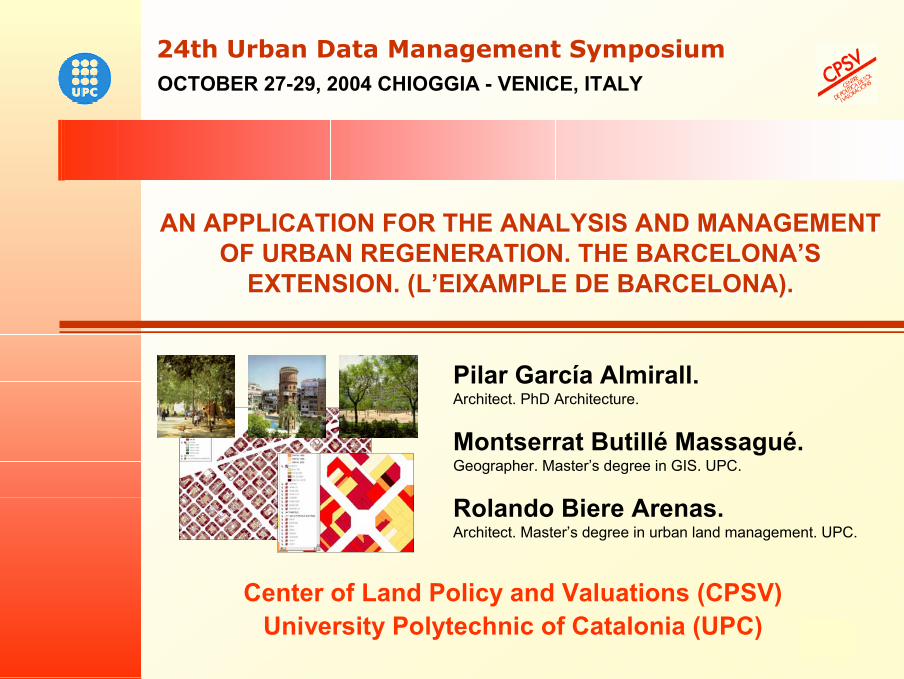
AN APPLICATION FOR THE ANALYSIS AND MANAGEMENT OF URBAN REGENERATION. THE BARCELONA’S
EXTENSION. (L’EIXAMPLE DE BARCELONA).
AN APPLICATION FOR THE ANALYSIS AND MANAGEMENT OF URBAN REGENERATION. THE BARCELONA’S
EXTENSION. (L’EIXAMPLE DE BARCELONA).
OCTOBER 27-29, 2004 CHIOGGIA - VENICE, ITALY24th Urban Data Management Symposium24th Urban Data Management Symposium
Pilar García Almirall.Architect. PhD Architecture.
Montserrat Butillé Massagué.Geographer. Master’s degree in GIS. UPC.
Rolando Biere Arenas.Architect. Master’s degree in urban land management. UPC.
Center of Land Policy and Valuations (CPSV)University Polytechnic of Catalonia (UPC)
2
An application for the analysis and management of urban regeneration. The Barcelona’s extension.
24th Urban Data Management Symposium24th Urban Data Management Symposium
THE PROCESS OF URBAN REGENERATION
THE EXPERIENCE IN BARCELONA’S EXTENSION
GOAL WORKING PLAN
SYSTEM’S STRUCTURE
MAIN FUNCTIONALITY
RESULTS AND CONCLUSIONS
PRESENTATION
3
THE PROCESS OF URBAN REGENERATION
The complexity of the processes of urban regeneration derives from the difficulty the city built with all of them to reorder their conditions and
restrictions, which seem insurmountable, when it is a matter of transforming areas into big cities.
It is basic to incorporate tools of digital cartography and GIS to describe the urban reality with all their attributes, in order to show the background and essential referents to study every case and to define
an adequate intervention, that answers to the citizens needs, of a feasible form, in the processes of urban transformation.
normative aspects,historical elements,
consolidated properties and rights,predominant uses,
socioeconomic effects,social and environmental needs
An application for the analysis and management of urban regeneration. The Barcelona’s extension.
24th Urban Data Management Symposium24th Urban Data Management Symposium
4
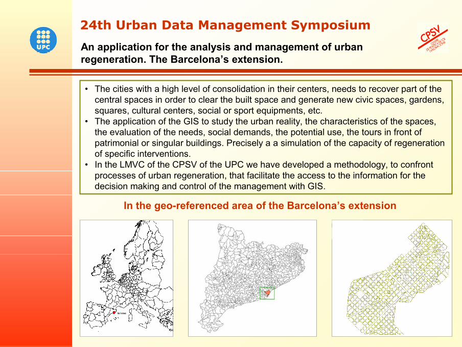
In the geo-referenced area of the Barcelona’s extension
An application for the analysis and management of urban regeneration. The Barcelona’s extension.
24th Urban Data Management Symposium24th Urban Data Management Symposium
• The cities with a high level of consolidation in their centers, needs to recover part of the central spaces in order to clear the built space and generate new civic spaces, gardens, squares, cultural centers, social or sport equipments, etc.
• The application of the GIS to study the urban reality, the characteristics of the spaces, the evaluation of the needs, social demands, the potential use, the tours in front of patrimonial or singular buildings. Precisely a a simulation of the capacity of regeneration of specific interventions.
• In the LMVC of the CPSV of the UPC we have developed a methodology, to confront processes of urban regeneration, that facilitate the access to the information for the decision making and control of the management with GIS.
5
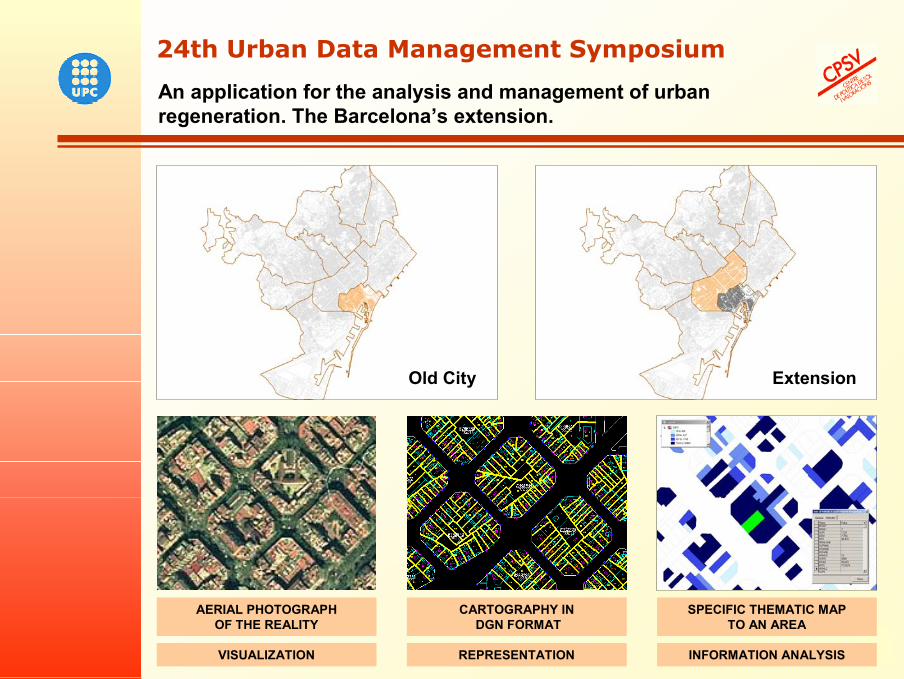
AERIAL PHOTOGRAPH OF THE REALITY
CARTOGRAPHY INDGN FORMAT
VISUALIZATION REPRESENTATION
SPECIFIC THEMATIC MAPTO AN AREA
INFORMATION ANALYSIS
An application for the analysis and management of urban regeneration. The Barcelona’s extension.
24th Urban Data Management Symposium24th Urban Data Management Symposium
Old City Extension
6
An application for the analysis and management of urban regeneration. The Barcelona’s extension.
24th Urban Data Management Symposium24th Urban Data Management Symposium
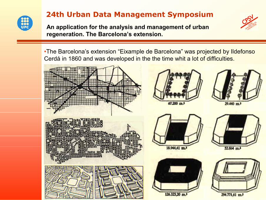
•The Barcelona’s extension “Eixample de Barcelona” was projected by Ildefonso Cerdá in 1860 and was developed in the the time whit a lot of difficulties.
7
An application for the analysis and management of urban regeneration. The Barcelona’s extension.
24th Urban Data Management Symposium24th Urban Data Management Symposium
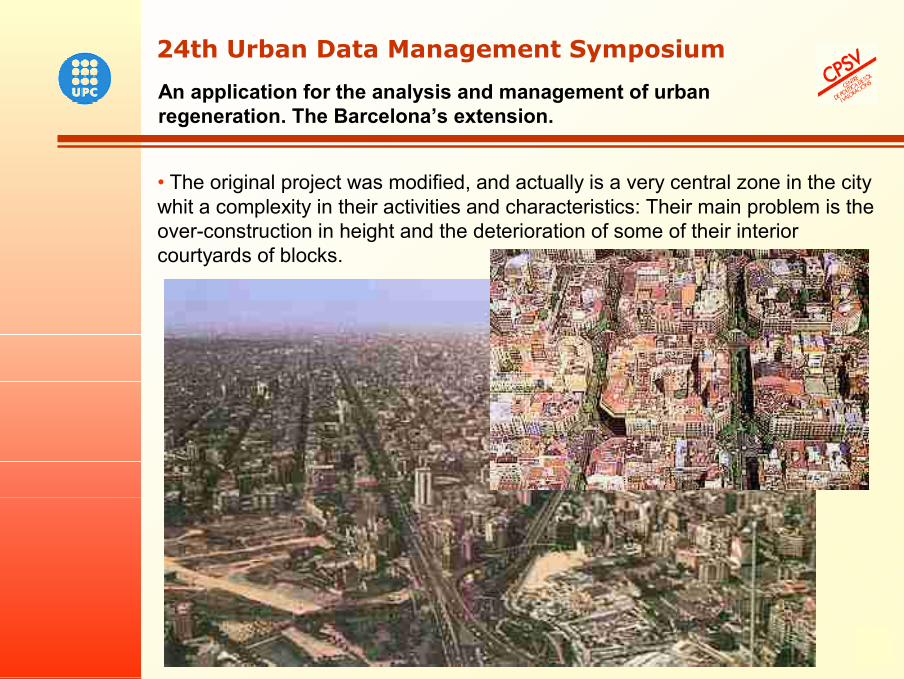
• The original project was modified, and actually is a very central zone in the city whit a complexity in their activities and characteristics: Their main problem is the over-construction in height and the deterioration of some of their interior courtyards of blocks.
8
THE EXPERIENCE IN BARCELONA’S EXTENSIONIn Barcelona, this need for regeneration is orientated to recover part of the interior courtyards of the blocks of the Eixample, since many of them are very deteriorated or they are underused. This initiative of the Town Council of Barcelona is developed by PROEIXAMPLE S.A. through a city planning:
Transforming the courtyards and to convert them in urban open spaces, for that at least one of every nine blocks of the Eixample it has an interior urban open space and to assure the neighbors a green zone to less than 200 meters of their house.
That requires an exhaustive knowledge of the constructions, activities, occupation or abandonment of the interior spaces, thus as conveying all the process of transformation (change of owners, redefinition of the space, etc...) with the treatment and management of a great volume of information, functions that the GIS, which facilitates the study plunges, visualization of every stage and the decision making on where and as acting.
PLAN GLOBAL DE RECUPERACIÓN DE INTERIORES DE MANZANA.GLOBAL PLAN OF RECOVERY OF INTERIORS OF BLOCK.
With the integration into a GIS of the different available bases in PROEIXAMPLE and others of Municipal area, the visualization of the urban space, the management and consulting of information related to the pre-existences of the different centers of block, and to their appropriateness is facilitated or not to be transformed into green zones.
An application for the analysis and management of urban regeneration. The Barcelona’s extension.
24th Urban Data Management Symposium24th Urban Data Management Symposium
9
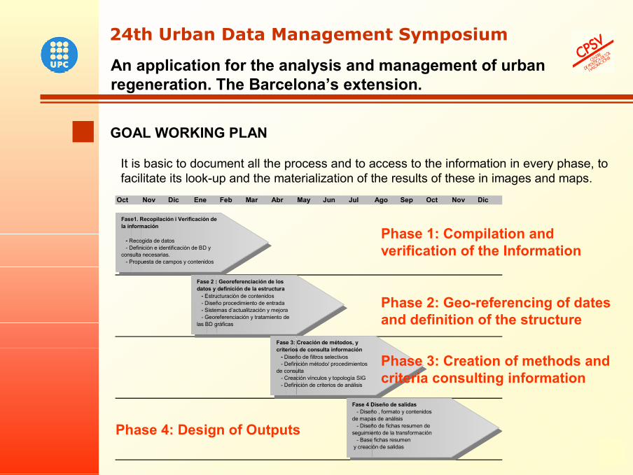
It is basic to document all the process and to access to the information in every phase, to facilitate its look-up and the materialization of the results of these in images and maps.
GOAL WORKING PLAN
Oct Nov Dic Ene Feb Mar Abr May Jun Jul Ago Sep Oct Nov Dic
Fase1. Recopilación i Verificación de la información
- Recogida de datos - Definición e identificación de BD y consulta necesarias. - Propuesta de campos y contenidos
Fase 2 : Georeferenciación de los datos y definición de la estructura - Estructuración de contenidos - Diseño procedimiento de entrada - Sistemas d’actualitzación y mejora - Georeferenciación y tratamiento de las BD gráficas
Fase 3: Creación de métodos, y criterios de consulta información - Diseño de filtros selectivos - Definición método/ procedimientos de consulta - Creación vínculos y topología SIG - Definición de criterios de análisis
Fase 4 Diseño de salidas - Diseño , formato y contenidos de mapas de análisis - Diseño de fichas resumen de seguimiento de la transformación - Base fichas resumen y creación de salidas
An application for the analysis and management of urban regeneration. The Barcelona’s extension.
24th Urban Data Management Symposium24th Urban Data Management Symposium
Phase 1: Compilation and verification of the Information
Phase 2: Geo-referencing of dates and definition of the structure
Phase 4: Design of Outputs
Phase 3: Creation of methods and criteria consulting information
10
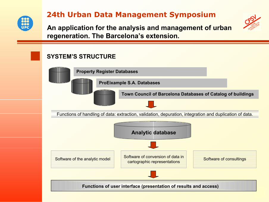
SYSTEM’S STRUCTURE
An application for the analysis and management of urban regeneration. The Barcelona’s extension.
24th Urban Data Management Symposium24th Urban Data Management Symposium
Functions of handling of data: extraction, validation, depuration, integration and duplication of data.
Software of the analytic model Software of conversion of data in cartographic representations
Software of consultings
Functions of user interface (presentation of results and access)
Property Register Databases
ProEixample S.A. Databases
Town Council of Barcelona Databases of Catalog of buildings
Analytic database
11
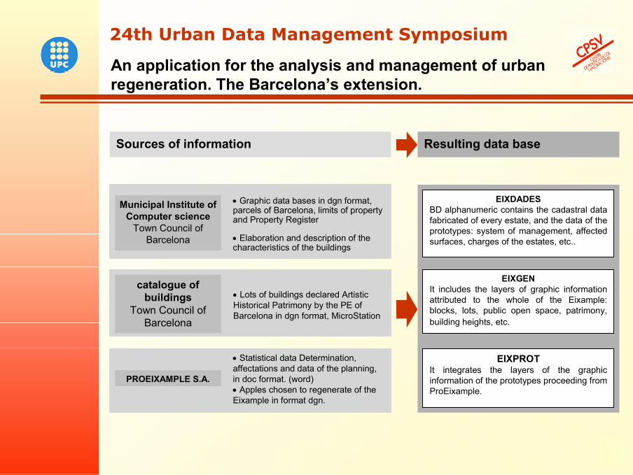
Municipal Institute of Computer science
Town Council of Barcelona
Sources of information
PROEIXAMPLE S.A.
Resulting data base
EIXDADESBD alphanumeric contains the cadastral data fabricated of every estate, and the data of the prototypes: system of management, affected surfaces, charges of the estates, etc..
EIXGENIt includes the layers of graphic information attributed to the whole of the Eixample: blocks, lots, public open space, patrimony, building heights, etc.
• Statistical data Determination, affectations and data of the planning, in doc format. (word) • Apples chosen to regenerate of the Eixample in format dgn.
• Graphic data bases in dgn format, parcels of Barcelona, limits of property and Property Register
• Elaboration and description of the characteristics of the buildings
EIXPROTIt integrates the layers of the graphic information of the prototypes proceeding from ProEixample.
• Lots of buildings declared Artistic Historical Patrimony by the PE of Barcelona in dgn format, MicroStation
catalogue of buildings
Town Council of Barcelona
An application for the analysis and management of urban regeneration. The Barcelona’s extension.
24th Urban Data Management Symposium24th Urban Data Management Symposium
12
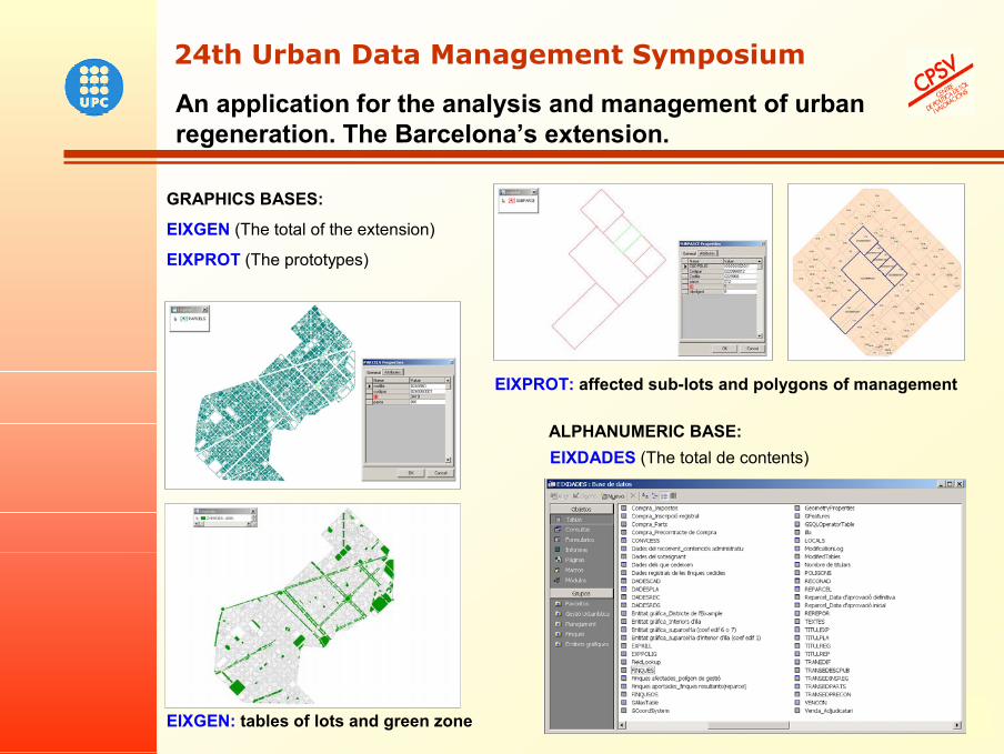
ALPHANUMERIC BASE:EIXDADES (The total de contents)
GRAPHICS BASES:
EIXGEN (The total of the extension)
EIXPROT (The prototypes)
EIXGEN: tables of lots and green zone
EIXPROT: affected sub-lots and polygons of management
An application for the analysis and management of urban regeneration. The Barcelona’s extension.
24th Urban Data Management Symposium24th Urban Data Management Symposium
13
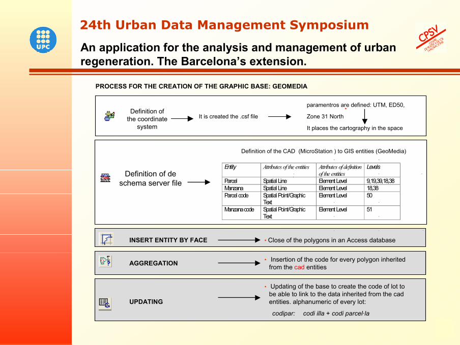
PROCESS FOR THE CREATION OF THE GRAPHIC BASE: GEOMEDIA
• paramentros are defined: UTM, ED50,
Zone 31 North•
It places the cartography in the space
Definition of the CAD (MicroStation ) to GIS entities (GeoMedia)
• Updating of the base to create the code of lot to be able to link to the data inherited from the cad entities. alphanumeric of every lot:
codipar: codi illa + codi parcel·la
UPDATING
• Close of the polygons in an Access databaseINSERT ENTITY BY FACE
It is created the .csf file
• Insertion of the code for every polygon inherited from the cad entitiesAGGREGATION
Definition ofthe coordinate
system
Definition of de schema server file
Entity Attributes of the entities Attributes of definition of the entities
Levels
Parcel Spatial Line Element Level 9,19,39,18,38 Manzana Spatial Line Element Level 18,38 Parcel code Spatial Point/Graphic
Text Element Level 50
Manzana code Spatial Point/Graphic Text
Element Level 51
An application for the analysis and management of urban regeneration. The Barcelona’s extension.
24th Urban Data Management Symposium24th Urban Data Management Symposium
14
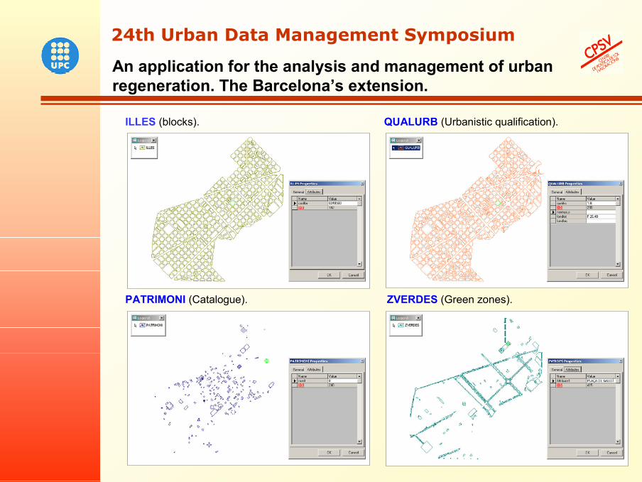
ILLES (blocks). QUALURB (Urbanistic qualification).
PATRIMONI (Catalogue). ZVERDES (Green zones).
An application for the analysis and management of urban regeneration. The Barcelona’s extension.
24th Urban Data Management Symposium24th Urban Data Management Symposium
15
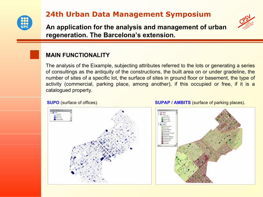
MAIN FUNCTIONALITYThe analysis of the Eixample, subjecting attributes referred to the lots or generating a series of consultings as the antiquity of the constructions, the built area on or under gradeline, the number of sites of a specific lot, the surface of sites in ground floor or basement, the type of activity (commercial, parking place, among another), if this occupied or free, if it is a catalogued property.
SUPO (surface of offices). SUPAP / AMBITS (surface of parking places).
An application for the analysis and management of urban regeneration. The Barcelona’s extension.
24th Urban Data Management Symposium24th Urban Data Management Symposium
16
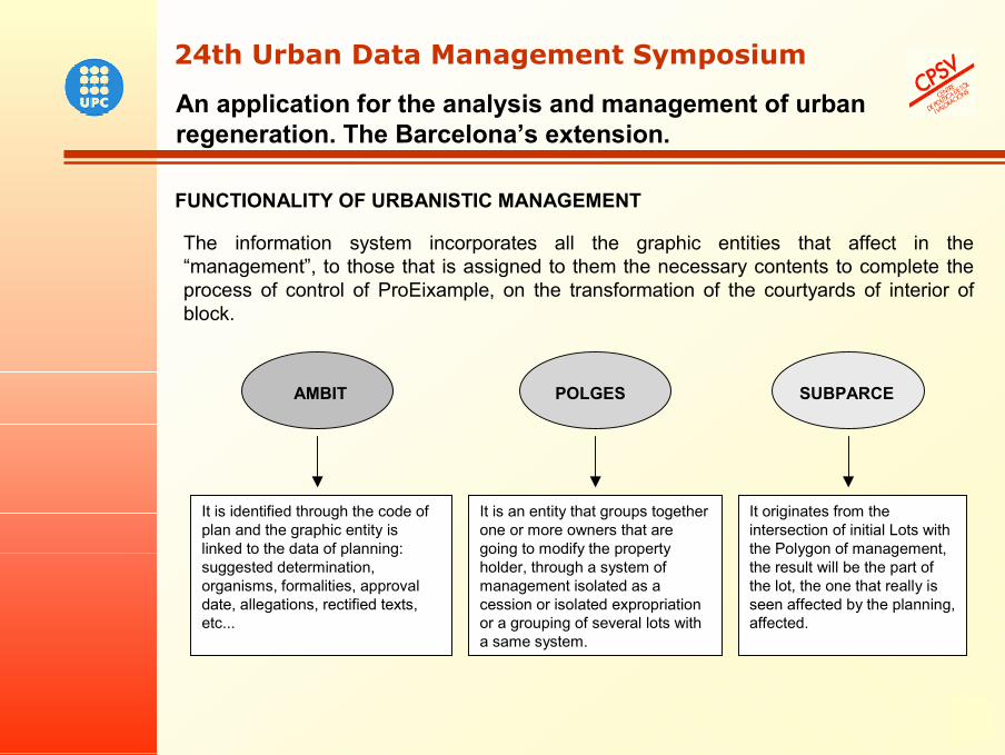
FUNCTIONALITY OF URBANISTIC MANAGEMENT
The information system incorporates all the graphic entities that affect in the “management”, to those that is assigned to them the necessary contents to complete the process of control of ProEixample, on the transformation of the courtyards of interior of block.
AMBIT POLGES
It is identified through the code of plan and the graphic entity is linked to the data of planning: suggested determination, organisms, formalities, approval date, allegations, rectified texts, etc...
It is an entity that groups together one or more owners that are going to modify the property holder, through a system of management isolated as a cession or isolated expropriation or a grouping of several lots with a same system.
It originates from the intersection of initial Lots with the Polygon of management, the result will be the part of the lot, the one that really is seen affected by the planning, affected.
SUBPARCE
An application for the analysis and management of urban regeneration. The Barcelona’s extension.
24th Urban Data Management Symposium24th Urban Data Management Symposium
17
An application for the analysis and management of urban regeneration. The Barcelona’s extension.
24th Urban Data Management Symposium24th Urban Data Management Symposium
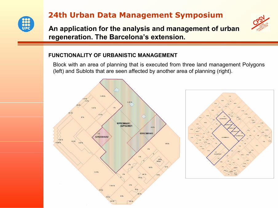
FUNCTIONALITY OF URBANISTIC MANAGEMENTBlock with an area of planning that is executed from three land management Polygons (left) and Sublots that are seen affected by another area of planning (right).
18
An application for the analysis and management of urban regeneration. The Barcelona’s extension.
24th Urban Data Management Symposium24th Urban Data Management Symposium
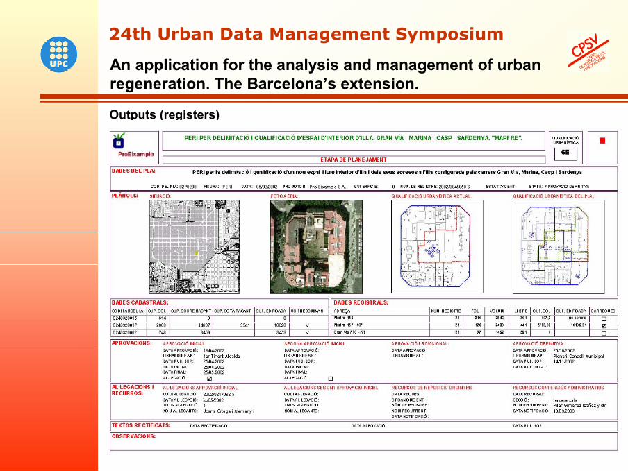
Outputs (registers)
19
An application for the analysis and management of urban regeneration. The Barcelona’s extension.
24th Urban Data Management Symposium24th Urban Data Management Symposium
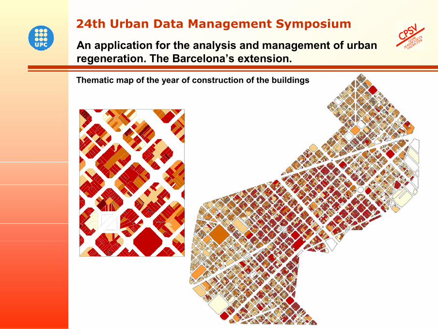
Thematic map of the year of construction of the buildings
20
An application for the analysis and management of urban regeneration. The Barcelona’s extension.
24th Urban Data Management Symposium24th Urban Data Management Symposium
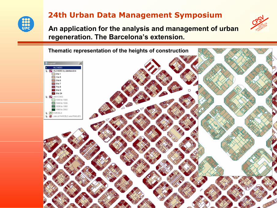
Thematic representation of the heights of construction
21
RESULTS AND CONCLUSIONS
A model of integration of data develops geo-referenced in a GIS channeled to processes of urban regeneration. It defines a structure of bases of urban information of the Eixample of Barcelona (of property register, of census of inhabitants, etc…) capable of providing descriptors as for lot, related to the structure of the property, predominant uses, activities and occupation, among others.
Outlining a methodology and a practical procedure for the incorporation of the urban characteristics in a GIS that improves the follow-up and control of the stages that concern the processes of transformation or regeneration of the city in a specific urban area of Barcelona.
At all times it allows to carry out a follow-up (registers) continued of the process of regeneration, on the base of a general information and of detail that allows to incorporate new contents up to its complete execution, so that PROEIXAMPLE S.A. has a precise vision of every stage of the process.
The tool Geomedia allows facilitating this task in so far as it is the program that allows first of all the linking of the data, the selective consulting of information represented on the reality, as well as the construction of space relations among the urban characteristics and a follow-up of the process of urban transformation.
An application for the analysis and management of urban regeneration. The Barcelona’s extension.
24th Urban Data Management Symposium24th Urban Data Management Symposium
22
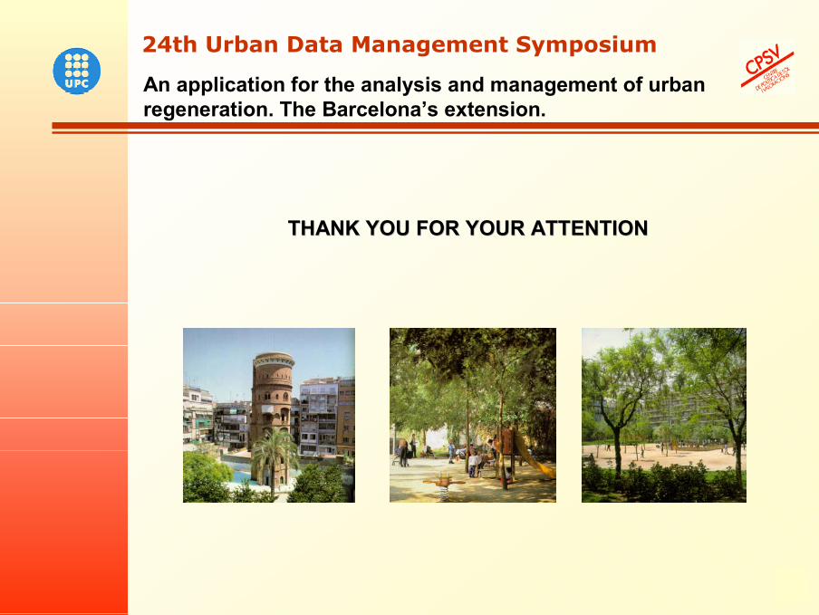
THANK YOU FOR YOUR ATTENTIONTHANK YOU FOR YOUR ATTENTION
An application for the analysis and management of urban regeneration. The Barcelona’s extension.
24th Urban Data Management Symposium24th Urban Data Management Symposium