20th street streetscape plan - kcmo.govkcmo.gov/.../uploads/2013/07/20thstreetstreetscape.pdf5...
TRANSCRIPT

20th Street Streetscape Plan


3
acknow ledgemen ts
Acknowledgements
MayorSly James
City ManagerTroy Schulte
City CouncilDick Davis...............................................................................1st District
Scott Wagner..............................................................1st District-at-Large
Russ Johnson.........................................................................2nd District
Ed Ford.....................................................................2nd District-at-Large
Jermaine Reed........................................................................3rd District
Melba Curls...............................................................3rd District-at-Large
Jan Marcason..........................................................................4th District
Jim Glover..................................................................4th District-at-Large
Michael Brooks........................................................................5th District
Cindy Circo................................................................5th District-at-Large
John A. Sharp..........................................................................6th District
Scott Taylor................................................................6th District-at-Large
The planning process participants expressed the desire to recognize the past mayor and city council, who
were in place during the time of this planning process, for their support of the 20th Street Streetscape Plan.
MayorMark Funkhouser
City CouncilBill Skaggs..............................................................................1st District
Deb Hermann.............................................................1st District-at-Large
Russ Johnson.........................................................................2nd District
Ed Ford.....................................................................2nd District-at-Large
Sharon Sanders Brooks...........................................................3rd District
Melba Curls...............................................................3rd District-at-Large
Jan Marcason..........................................................................4th District
Beth Gottstein............................................................4th District-at-Large
Terry Riley...............................................................................5th District
Cindy Circo................................................................5th District-at-Large
John A. Sharp..........................................................................6th District
Cathy Jolly.................................................................6th District-at-Large

4 20th street streetsCape plan
acknow ledgemen ts
steering Commitee
Suzie Aron......................................................................Aron Real Estate
Manny Lopez.................................................Manny’s Mexican Restaurant
Shane Glazer..........................................................................The Cashew
Dick Belger...................................................................Belger Arts Center
Kevin McGowan.................................................................The Piper Lofts
Bob Ehinger................................................................Ehinger Real Estate
Dan Clothier...........................................................Standard Management
Sherry Leedy............................................Sherry Leedy Contemporary Art
Mary Kennedy McCabe....................................Mid American Arts Alliance
Tom Nelson......................................................................................BNIM
Mario Rojas...................................................................Westside Resident
Lynda Callon............................................................Westside CAN Center
Kathryn Shields.............................................................Westside Housing
Bill Dietrich..................................................................Downtown Council
John Fairfield................................................................Downtown Council
Lyndon Wade....................................................................................Artist
Warren Rosser...................................................................KC Art Institute
technical Committee
Keith Sanders.................................................................................KCATA
Danny O’Connor..............................................................................KCATA
Steven Hatfield.........................................................Parks and Recreation
Rick Usher................................................................City Manager’s Office
Jeff Martin...........................................................................Public Works
Mario Vasquez................................................Public Works – Streetscape
Victor Pecina.................................................Public Works – Street Lights
Wei Sun................................................Public Works – Streets and Traffic
Terry Leeds........................................................................Water Services
Mark Govea........................................................................Water Services
Francis Reddy.....................................................................Water Services
Geri Doyle......................................................................................MoDOT
Natasha Clausell.............................................................................KCP&L
Greg Elliot.......................................................................................KCP&L
5
acknow ledgemen ts
City planning and Development
Tom Coyle, AICP – Director, City Planning and Development
Jade Liska, ASLA/RLA – Division Manager, Citywide Planning
John DeBauche, AICP – Project Manager
Consulting team
el dorado inc
urban design, architecture
patti Banks associates
landscape architecture
taliaferro and Browne
civil engineering
nevue ngan associates
green solutions, landscape architecture
Derek porter studio
lighting design
r^3C
traffic engineering


t ab l e o f con ten t s
7
Table of ContentsIntroduction
1.0 existing Condition analysis
2.0 Goals and recommendations
3.0 Concept plans 3.1 Central Street to Wyandotte Street
3.2 Wyandotte Street to Baltimore Avenue
3.3 Baltimore Avenue to Main Street
3.4 Main Street to Walnut Street
3.5 Walnut Street to Grand Boulevard
3.6 Grand Boulevard to McGee Street
3.7 Four-Lane Option
4.0 Implementation 4.1 Recommended Phasing
4.2 Cost Opinions
4.3 Funding Opportunities
9
11
15
23
35

i n t r oduc t i on
9
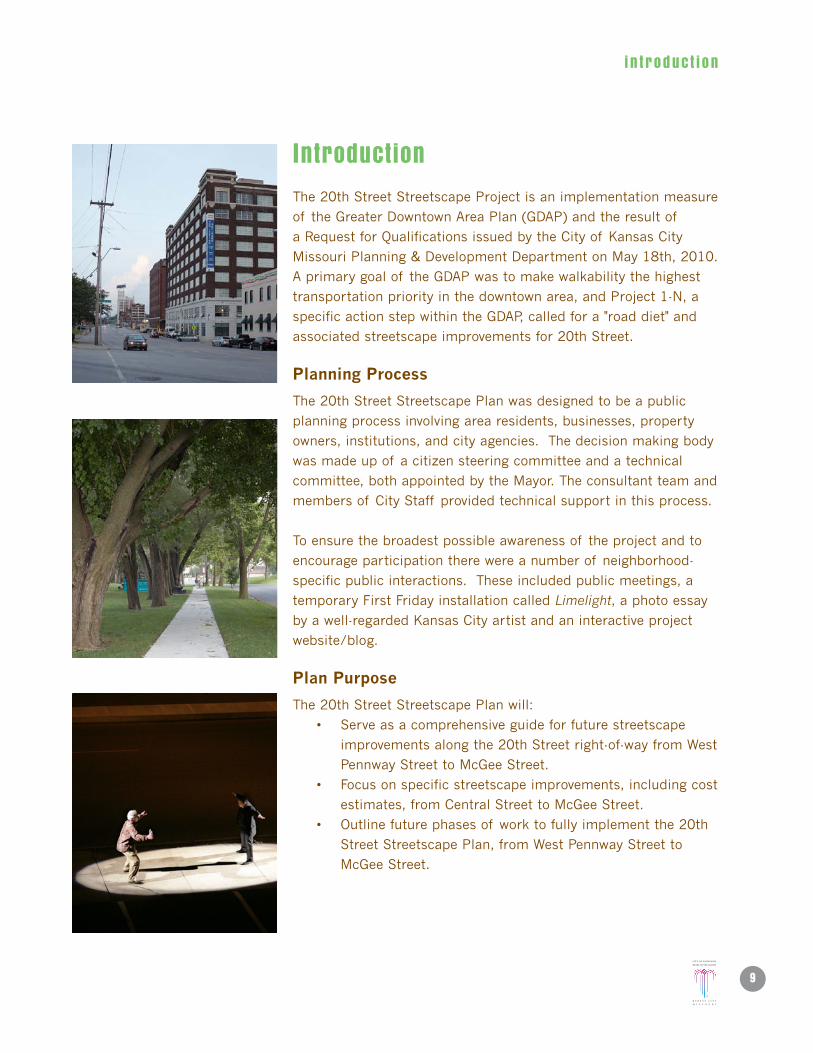
Introduction
The 20th Street Streetscape Project is an implementation measure
of the Greater Downtown Area Plan (GDAP) and the result of
a Request for Qualifications issued by the City of Kansas City
Missouri Planning & Development Department on May 18th, 2010.
A primary goal of the GDAP was to make walkability the highest
transportation priority in the downtown area, and Project 1-N, a
specific action step within the GDAP, called for a "road diet" and
associated streetscape improvements for 20th Street.
planning process
The 20th Street Streetscape Plan was designed to be a public
planning process involving area residents, businesses, property
owners, institutions, and city agencies. The decision making body
was made up of a citizen steering committee and a technical
committee, both appointed by the Mayor. The consultant team and
members of City Staff provided technical support in this process.
To ensure the broadest possible awareness of the project and to
encourage participation there were a number of neighborhood-
specific public interactions. These included public meetings, a
temporary First Friday installation called Limelight, a photo essay
by a well-regarded Kansas City artist and an interactive project
website/blog.
plan purpose
The 20th Street Streetscape Plan will:
• Serveasacomprehensiveguideforfuturestreetscape
improvements along the 20th Street right-of-way from West
Pennway Street to McGee Street.
• Focusonspecificstreetscapeimprovements,includingcost
estimates, from Central Street to McGee Street.
• Outlinefuturephasesof worktofullyimplementthe20th
Street Streetscape Plan, from West Pennway Street to
McGee Street.

i n t r oduc t i on
10 20th street streetsCape plan
Any recommendations made in this document will be more fully
defined during subsequent phases of work. The purpose of this
document is to initiate Project 1–N in the GDAP's implementation
matrix and create a unified, cohesive streetscape framework that
supports the five primary goals of the GDAP:
• Createawalkabledowntown.
• Doublethepopulationdowntown.
• Increaseemploymentdowntown.
• Retainandpromotesafe,authenticneighborhoods.
• Promotesustainability.
project study area
The 20th Street Streetscape Master Plan study area was originally
defined in the Request for Qualifications as 20th Street from I-35
to McGee Street. However, due to planned improvements by Parks
and Recreation on West Pennway Street, as well as by Public
Works and Missouri Department of Transportation on I-35 and
surrounding on/off ramps, it was agreed to redefine the overall
study area as: 20th Street from West Pennway Street to McGee
Street, with a more detailed focus on the area from Central Street
to McGee Street.
The study area is mostly public right-of-way, but it does include
considerations for reconfiguring both public right-of-way and
private property for mutual benefit. These areas include the “Bow
Tie Park” at Southwest Boulevard and 20th Street and “Walnut
Flyway” at Walnut Street and 20th Street.
plan Organization
The 20th Street Streetscape Master Plan is divided into four (4)
sections:
• 1.0:ExistingConditionAnalysis
• 2.0:GeneralGoalsandRecommendations
• 3.0:ConceptPlans
• 4.0:Implementation
nOrth

1 . 0 ex i s t i ng cond i t i on ana l ys i s
11
1.0 Existing Condition Analysis
An existing condition survey was completed to assess the physical
state of the project area, with a focus on 20th Street, from Central
Street to McGee Street. Broadly speaking, the corridor is a
patchwork of minor repairs made over the years, either by various
public agencies or private interests. Utilities will be selectively
relocated pending further design development and coordination
with the various utility agencies.
GIS information was analyzed to provide a preliminary
understanding of stormwater surface volumes and directional
flows. This information provided guidance for sizing and locating
proposed stormwater BMP catchments.
The following items were evaluated:
• Surfaces • Parking
• StormUtilities • Vaults
• Utilities • ExistingBuildings
• WaterLines • EnvironmentalObservations
• Traffic
surfaces
The street surface appears to be adequate throughout the corridor,
though potholes and metal plates are common. For the purposes
of this plan we have assumed that all surfaces and subsurfaces
will be improved to create a unified public space and multi-modal
transit corridor.
Sidewalks in the corridor are serviceable. They are frequently
cracked and uneven. ADA curb cuts at intersections are sporadic,
and abandoned curb cuts create steep cross slopes and uneven
sidewalk surfaces.
storm Utilties
All sewer main lines within the project area are combined storm
and sanitary. Less than ten years ago the sewer lines were lined by
the Water Services Department to improve functionality.

1 . 0 ex i s t i ng cond i t i on ana l ys i s
12 20th street streetsCape plan
Many catch basins are below the surface of the road and pose a
tripping hazard. Subsequent analysis of the overall functionality
of the existing stormwater system and the impact of proposed
stormwater BMP’s is needed.
Utilities
Kansas City Power and Light and the City of Kansas City, Missouri
provided subsurface utility location information. The area’s
electrical distribution is primarily above ground and can be
visually identified. Current streetscape work at 20th Street and
Wyandotte Street provided actual locations of certain key utilities:
sewer, electrical, gas and telecommunications.
Water lines
The condition of the water main in the study area is unknown.
However, during the course of this project the water main just
west of Grand Boulevard broke repeatedly. A more thorough
analysis, working with the Water Services Department, is needed
to determine the extent of needed improvements. Any substantial
subsurface utility work ought to take place before or concurrently
with 20th Street Streetscape improvements.
traffic
Per the recommendations of the 22nd/23rd Street Connector
Plan, adopted by Resolution 060189 on May 18, 2006, as well
as suggestions in the Request For Qualifications, we are exploring
the possibility of a “road diet” for the 20th Street corridor from
Southwest Boulevard to McGee Street. The conceptual plans have
been discussed with major stakeholders in the area including
Crown Center Redevelopment, the Freighthouse Development and
business/property owners along the corridor.
parking
With the increase in both residents and retail/restaurant
businesses along 20th Street in recent years the demand for
parking is high. Diagonal parking just north of 20th Street on
McGee Street was recently completed to increase the number of
parking stalls in the public right-of-way. Given the stakeholder-
defined prioritization of walkability and devoting more right-of-

1 . 0 ex i s t i ng cond i t i on ana l ys i s
13
way space to a broader northern sidewalks it was determined
not to propose diagonal parking along 20th Street. However,
the conceptual plans do illustrate an increase in the number of
on-street parking stalls from 65 to 70.
transit
20th Street is a major bus corridor with a number of routes
running through it and crossing it, including the Main Street MAX
line. It crosses both Grand Boulevard and Main Street, the City's
designated fixed guideway transit corridor. The corridor also
serves a number of regional bus lines.
Vaults
The southern sidewalk along 20th Street from Southwest
Boulevard to McGee Street is replete with existing building vaults.
At least half of the larger the buildings are known to have them.
In addition, KCPL has a major underground vault just north of
the southern curb line from Main to Grand. The streetscape
improvements take a conservative approach towards vaults,
leaving the southern sidewalk free of any plantings or alterations
that would compromise the current conditions.
existing Buildings
The 20th Street corridor from Southwest Boulevard to McGee
Street is lined with some of the area's most significant buildings,
historical warehouse structures and office buildings from the
early 20th century. Many on are the National Register of Historic
Places. It will be essential to leverage these cultural assets by
establishing an urban space-defining balance of buildings to the
south and landscape to the north.
environmental Observations
Over the course of this project the design team spent many
hours walking the project area, observing the site at different
times of day and throughout the week. Subtle, but important
information about the corridor was gained, including ambient
summer temperatures impacted by building shading and summer
breezes, as well as where vehicular behavior negatively impacts
the pedestrian experience.


2 .0 genera l goa l s & recommenda t i ons
15
2.0 Goals and Recommendations
The 20th Street Streetscape Plan is one of the first projects to be
explicitly implemented as a result of the Greater Downtown Area
Plan (GDAP). It is intended to support the five primary goals of
the plan as well. They are:
Create a walkable downtown.
Double the population downtown.
Increase employment downtown.
Retain and promote safe, authentic neighborhoods.
Promote sustainability.
The recommendations within the plan are organized around each
of these goals, though many of them support more than one
GDAP goal. Further details about specific recommendations and
how they are applied on a block-by-block basis can be found in
section 3.0 Concept Plans.
Goal 1: Create a walkable downtown.
recommendation 1a: put 20th street on a “road diet.”
The 20th Street Streetscape Plan supports this goal in a number
of ways. First, by proposing a “road diet” for the entire length
of 20th Street from Southwest Boulevard to McGee Street, 12
to 20 feet of roadway on the north side of 20th Street will be
re-purposed as sidewalks, landscape, streetscape amenities and
stormwater BMP’s.
More detailed analysis is required to confirm that road
functionality is not compromised by the “road diet,” however
significant stakeholders in the area, including Crown Center
Redevelopment, the Freighthouse Development and individual
business and property owners along the corridor, support
the idea. The idea was first introduced as part of the City's
22nd/23rd Street Connector and Crosstown Circle Planning Study,
Resolution 060189 adopted on May 18, 2006.

2 .0 genera l goa l s & recommenda t i ons
16 20th street streetsCape plan
recommendation 1B: slow traffic through narrower lanes and
planted curb extensions.
The current corridor is a wide open roadway facilitating fast
moving vehicles. The introduction of these traffic calming
measures will help establish the corridor as a pedestrian friendly,
walkable corridor, while maintaining a functional, safe roadway for
vehicular traffic.
recommendation 1C: provide pedestrian orientation through
appropriate signage and wayfinding.
Currently the signage along 20th Street is focused exclusively on
vehicular orientation. We recommend first taking an inventory of
existing signage, then incorporating appropriately scaled signage
and wayfinding to help orient visitors to neighborhood destinations
and amenities.
recommendation 1D: Create wider than standard crosswalk
striping.
Given the current volume of visitors to the Crossroads on First
Fridays and other programmed event days (like Second Saturdays
to support retail businesses in the neighborhood) we recommend
10’ crosswalks at all intersections along the 20th Street corridor.
As development and density in the area increase, the crosswalks
will accommodate the larger population and improve livability for
residents.
recommendation 1e: Install pedestrian friendly signalization.
Drivers are used to taking cues from traffic signals. In the next
phase of work, we recommend exploring a range of integrated
pedestrian signals that recognize this fact and will help establish
the corridor as a pedestrian friendly corridor.
recommendation 1F: support all forms of transit.
It is our goal to make 20th Street a complete street that will
accomodate all forms of transportation, including bicycles,
Pedestrian /Furnishing Zone Planter /
Parallel ParkingStorm
3’
~31’ 8’
8’ ~11’
5’5’
11’11’10’6”
BikeLane Bike
LanePlanter /
Parallel ParkingPedestrian /
Furnishing ZoneTraffic Lane
Traffic LaneTurn Lane
(Permeable)

2 .0 genera l goa l s & recommenda t i ons
17
pedestrians, cars, current public transportation and future bus
and transit routes.
recommendation 1G: replace sidewalks and curb cuts in the
project area, with the exception of recent improvements. Install
aDa ramps at all intersections.
Given the popularity of the area as an arts and cultural district,
highlighted by the hundreds of people regularly attending First
Fridays, it is proposed to replace all of the sidewalks and curbs
in the project area, recent improvements being the exception. We
propose eliminating unused curb cuts as well.
Goal 2: Double the population downtown.
This project cannot directly address this goal. However, by creating
quality public spaces that support the desires and needs of urban
residents currently dwelling along the 20th Street corridor this
project indirectly supports this goal.
recommendation 2a: Discuss and promote the 20th street
streetscape plan as a development tool to attract new and
support existing residents downtown.
There are already large concentrations of residents on the east
and west ends of the project area, with affordable housing
developments being planned near 20th Street and Wyandotte
Street. The improvements to 20th Street will make the corridor
more livable and will attract future residents. Pre and post
implementation census data should be tracked for accurate
accounting of the impact.
recommendation 2B: Increase the availability of public green
space.
Green space is scarce in the downtown area. Planted areas in a
hard, urban environment, give residents and visitors places to
gather together, stop and rest, or walk dogs. They also reduce
heat gain and stormwater runoff. It is recommended to create a
"Bow Tie Park" from Central Street to Wyandotte Street, where
20th Street crosses Southwest Boulevard, expanding existing
green space.

2 .0 genera l goa l s & recommenda t i ons
18 20th street streetsCape plan
Goal 3: Increase employment downtown.
recommendation 3a: recognize that it’s already happening.
Design and construction work is supporting and will continue to
support a number of professional and construction firms located
in Kansas City’s urban core. The Downtown Council's report
entitled "Economic Impact of Downtown Kansas City, Missouri,"
projected a 10% growth in jobs located in the area from the years
2000 to 2010.
recommendation 3B: track pre and post-implementation job
statistics within 3 blocks of 20th street, including the number of
business and number of jobs.
Compare census data collected before and after the project is
completed. Coordinate with various organizations like the City
Planning and Development Department, Mid-America Regional
Council and Downtown Council, all of whom track this information.
recommendation 3C: Discuss and promote the 20th street
streetscape plan as an economic development tool to attract new
and support existing businesses downtown.
The 20th Street Streetscape Plan will assist the Economic
Development Corporation of Kansas City, the Downtown Council
and the staff of the future Crossroads CID in attracting and
supporting local businesses.
recommendation 3D: Introduce signage and wayfinding in
accordance with the City's existing wayfinding system.
An often-heard complaint from business owners and guests to
the Crossroads is the difficulty of finding smaller, tucked away
destinations. It is recommended to integrate business-supportive
signage along the corridor to provide orientation. There are also a
large number of not-for-profits in the immediate vicinity of 20th
Street. The signage would help identify them to the public as well.

2 .0 genera l goa l s & recommenda t i ons
19
Goal 4: retain & promote safe, authentic neighborhoods.
recommendation 4a: Keep the materials simple, durable and
easy to maintain.
The Crossroads prides itself on being a little rough around the
edges. We have translated this idea into an approach emphasizing
straightforward materials like City standard concrete for all of the
sidewalks and curbs. Another example is the staggered continental
crosswalk that takes into consideration the wear patterns of
vehicles.
recommendation 4B: Incorporate public art.
The Crossroads is home to a number of art galleries and artists’
studios. It is also home to the soon-to-open Kauffman Center for
the Performing Arts. This project will set a clear tone of contextual
sensitivity by incorporating public art. But it needs to be done
thoughtfully, via a process that is both respectful of best practices
and respected by the art community.
recommendation 4C: Create flexible space.
Repeatedly throughout the conceptual design process we heard
from stakeholders that they wanted flexible outdoor, public space.
20th Street and Baltimore Avenue has become the central location
for First Fridays given the concentration of galleries here. Events
have spilled out of the buildings and into the streets, all along the
corridor. A large promenade on the northern edge of 20th Street
and a curbless profile also on the northern edge will help facilitate
this desire.
recommendation 4D: Create Crossroads specific amenities
(benches, trash cans, bike racks, pedestrian lighting, public art,
wayfinding, etc).
The Crossroads prides itself on being unique. It is recommended
to develop a suite of Crossroads-specific streetscape amenities.
Some might be drawn from existing projects like the “martini”
lights from the Freighthouse streetscape work. Others might be
new for this project, but will be designed with an eye towards

2 .0 genera l goa l s & recommenda t i ons
20 20th street streetsCape plan
durability and ease of maintenance. These amenities will be
maintained by the future Crossroads CID.
recommendation 4e: respect the architectural heritage of the
corridor.
A high number of large, historically significant buildings line the
southern edge of 20th Street from Southwest Boulevard to McGee
Street. They form a very distinctive urban edge, in contrast to the
surface parking lots and the wide setbacks along the northern
edge of the corridor. Minimal tree planting is recommended along
the southern edge of the street, due to the presence of vaults
and the desire to maintain visibility of the structures. Along the
northern edge of the street, we recommend strategically planting
trees to create a clearly defined urban space.
Goal 5: promote sustainability.
recommendation 5a: Implement extensive stormwater BMp’s.
All of the proposed landscape improvements serve double duty.
First the trees and planted beds visually soften an otherwise
hardened urban environment. Second the planted beds and bulb
outs also function to slow down and cleanse storm water captured
from adjacent parking lots and streets.
recommendation 5B: Use pervious pavement where practical.
In the on street parking stalls and in the center turn lane at
minor intersections we propose using pervious asphalt to allow
additional surface stormwater to be slowed down before it enters
the hard-piped stormwater system.
recommendation 5C: plant an abundance of deciduous trees.
Deciduous trees improve air quality, provide a canopy in the
summer to reduce the Urban Heat Island Effect and allow passive
heating in the winter when they lose their leaves. A specific tree
and plant palette will be determined in the detailed design phase
of this project and approved by the City Forester.

2 .0 genera l goa l s & recommenda t i ons
21
Pedestrian /Furnishing Zone Planter /
Parallel ParkingStorm
3’
~31’ 8’
8’ ~11’
5’5’
11’11’10’6”
BikeLane Bike
LanePlanter /
Parallel ParkingPedestrian /
Furnishing ZoneTraffic Lane
Traffic LaneTurn Lane
(Permeable)
recommendation 5D: Create a truly multi-modal street.
Dedicated bike lanes indicate a commitment to alternative means
of circulation downtown and promote a more healthy lifestyle.
Southwest Boulevard and 19th Street are future bike routes on
Bike KC, the City's comprehensive bicycle plan. The City's Bicycle/
Pedestrian Coordinator supports the recommendation to add bike
lanes to 20th Street and connect to Southwest Boulevard and 19th
Street's approved routes.
recommendation 5e: Utilize energy efficient roadway and
pedestrian fixtures.
It is recommended that city-approved LED roadway fixtures be
used throughout the corridor. An energy efficient fixture that is
already part of the adjacent Freighthouse Streetscape standards
is recommended for pedestrian lights. This fixture utilizes indirect
down-lighting, efficiently directing light where it's needed and
reducing light pollution in support of the Dark Sky Initiative.
recommendation 5F: Use sustainable construction materials and
methods.
Materials and methods will be researched and specified in greater
detail during the next phase to ensure compliance with best
practices, guided by LEED construction standards.
recommendation 5G: Use passive irrigation.
Through a series of interconnected curb extensions and planted
beds on the northern side of 20th Street, collected stormwater
will be used to irrigate plant material, simultaneously cutting
down on the need to water and cleaning stormwater.
recommendation 5h: prepare for public/private maintenance.
In addition to assisting in the creation of a Crossroads CID, we
recommend the development of clear roles and responsibilities
in the maintenance of the 20th Street improvements, formalized
through a signed agreement between the CID and the City.
See 3.0 Concept Plans for illustrations of these recommendations being applied to specific
blocks along 20th Street.


3 .0 concep t p l ans
23
3.0 Concept Plans
The 20th Street Streetscape Plan proposes a complete, block-by-block public right-of-way
transformation from Central Street to McGee Street. Given the road geometry reconfiguration and
extensive utility work anticipated we recommend doing the Phase 1 work all at once, structured in a
way to minimize negative impact to local businesses and residents.
The proposed improvements on 20th Street are an opportunity to restore a balance between
pedestrian and vehicular movement for an area that needs quality public right-of-way (ROW), and
to set the stage for economic productivity. As it exists today, 20th Street is characterized by auto-
dominated movement, lack of green space, excessive impervious area and a bleak pedestrian
environment. At the same time there is a strong desire to engage the public space through art,
restaurants and retail. By redesigning the right-of-way to be a multifunctional pedestrian and green
space, the streetscape will function as a destination for the community.
Our concept plans indicate an attempt to standardize an approach along the entire corridor from
Southwest Boulevard to McGee Street. However, there are block-specific modifications to this
approach. For example, depending on the amount of stormwater flowing into 20th Street from the
north, curb extensions and the area of landscape strips can be adjusted to recognize differences.
The “Bow Tie Park,” which will be located from Central Street to Wyandotte Street, where 20th Street
crosses Southwest Boulevard, is a stand alone concept based on the unique geometry of the urban
grid along this section of 20th Street. Curb extensions to the north of 20th Street are tailored to the
specific curb cut situation of each side of the street.
0" 10' 20' 40'5'
Ce
nt
ra
l s
t
sOUth
Wes
t BlV
D
WYa
nD
Ot
te
st
W B
alt
IMO
re
aVe
Ma
In s
t
Wa
lnU
t s
t
Gr
an
D B
lVD
MC
Ge
e s
t

3 .0 concep t p l ans
24 20th street streetsCape plan
3.1 Central street to Wyandotte street
proposed streetscape elements:
• WestBowTieParkcreatedbyrelocatingparking
lot at 207 Southwest Boulevard to Central Street
and vacating Central from north/south public
access.
• Curbextensionswithinfiltrationplantersalong
Southwest Boulevard and 20th Street
• Improvedcrosswalks
• Groundlevelplantings
• Streettreesalong20thStreet
• 2)5’bikelaneswestof SouthwestBoulevard
• Newroadwaystriping
• Newcurbsandsidewalks,southsideof 20th
Street
• Curblesssidewalkonthenorthsideof 20th
Street, east of SW Boulevard
• Bollardsonnorthsideof 20th,locatedat
on-street parking
• Re-purposingof Wyandotteasgreen
space
• LargecalipertreesinEastandWestBow
Tie Park
• Stormwaterdetention/retentionbasins
(location TBD)
• Streetscapeamenitypackage(benches,
bike racks, trash cans, wayfinding, etc.)
• Improvedsignalization
• Utilityimprovementsandre-location
West BOW tIe parK

3 .0 concep t p l ans
25
3.1 Central street to Wyandotte street
proposed streetscape elements:
• WestBowTieParkcreatedbyrelocatingparking
at 207 Southwest Boulevard to Central Street
and vacating Central Street from north/south
public access.
• Curbextensionswithinfiltrationplantersalong
Southwest Boulevard and 20th Street
• Improvedcrosswalks
• Groundlevelplantings
• Streettreesalong20thStreet
• 2)5’bikelaneswestof SouthwestBoulevard
• Newroadwaystriping
• Newcurbsandsidewalks,southsideof 20th
Street
• Curblesssidewalkonthenorthsideof 20th
Street, east of SW Boulevard
• Bollardsonnorthsideof 20th,locatedat
on-street parking
• EliminatevehiculartrafficonWyandotte
Street between 20th Street and
Southwest Boulevard, re-purposing it as
green space.
• LargecalipertreesinEastandWestBow
Tie Park
• Stormwaterdetention/retentionbasins
(location TBD)
• Streetscapeamenitypackage(benches,
bike racks, trash cans, wayfinding, etc.)
• Improvedsignalization
• Utilityimprovementsandre-location
east BOW tIe parK

3 .0 concep t p l ans
26 20th street streetsCape plan
3.2 Wyandotte street to Baltimore avenue
proposed streetscape elements:
• Curbextensionswithinfiltrationplanters
• Improvedcrosswalks
• Streettrees
• Groundlevelplantings
• 2)5’bikelanes
• Newroadwaystriping
• Newcurbsandsidewalks
• Curblesssidewalkonthenorthsideof 20th
Street
• Bollardsonnorthsideof 20thStreet,locatedat
on-street parking
• Stormwaterdetention/retentionbasins(location
TBD)
• Streetscapeamenitypackage(benches,bike
racks, trash cans, wayfinding, etc.)
• Utilityimprovementsandre-location
• Permeablepavementinon-streetparking
stalls, center median (where indicated)
and alley aprons
3 .0 concep t p l ans
27
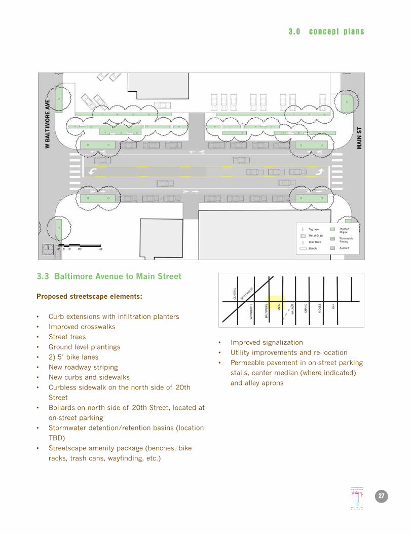
3.3 Baltimore avenue to Main street
proposed streetscape elements:
• Curbextensionswithinfiltrationplanters
• Improvedcrosswalks
• Streettrees
• Groundlevelplantings
• 2)5’bikelanes
• Newroadwaystriping
• Newcurbsandsidewalks
• Curblesssidewalkonthenorthsideof 20th
Street
• Bollardsonnorthsideof 20thStreet,locatedat
on-street parking
• Stormwaterdetention/retentionbasins(location
TBD)
• Streetscapeamenitypackage(benches,bike
racks, trash cans, wayfinding, etc.)
• Improvedsignalization
• Utilityimprovementsandre-location
• Permeablepavementinon-streetparking
stalls, center median (where indicated)
and alley aprons

3 .0 concep t p l ans
28 20th street streetsCape plan
3.4 Main street to Walnut street
proposed streetscape elements:
• Curbextensionswithinfiltrationplanters
• Improvedcrosswalks
• Streettrees
• Groundlevelplantings
• 2)5’bikelanes
• Newroadwaystriping
• Newcurbsandsidewalks
• Curblesssidewalkonthenorthsideof 20th
Street
• Bollardsonnorthsideof 20thStreet,locatedat
on-street parking
• Stormwaterdetention/retentionbasins(location
TBD)
• Streetscapeamenitypackage(benches,bike
racks, trash cans, wayfinding, etc.)
• Utilityimprovementsandre-location
• Permeablepavementinon-streetparking
stalls, center median (where indicated)
and alley aprons

3 .0 concep t p l ans
29
3.5 Walnut street to Grand Boulevard
proposed streetscape elements:
• Curbextensionswithinfiltrationplanters
• Improvedcrosswalks
• Streettrees
• Groundlevelplantings
• 2)5’bikelanes
• Newroadwaystriping
• Newcurbsandsidewalks
• Curblesssidewalkonthenorthsideof 20th
Street
• Bollardsonnorthsideof 20thStreet,locatedat
on-street parking
• Stormwaterdetention/retentionbasins(location
TBD)
• Streetscapeamenitypackage(benches,bike
racks, trash cans, wayfinding, etc.)
• Improvedsignalization
• Utilityimprovementsandre-location
• Permeablepavementinon-streetparking
stalls, center median (where indicated)
and alley aprons

3 .0 concep t p l ans
30 20th street streetsCape plan
3.6 Grand Boulevard to McGee street
proposed streetscape elements:
• Curbextensionswithinfiltrationplanters
• Improvedcrosswalks
• Streettrees
• Groundlevelplantings
• 2)5’bikelanes
• Newroadwaystriping
• Newcurbsandsidewalks
• Curblesssidewalkonthenorthsideof 20th
Street
• Bollardsonnorthsideof 20thStreet,locatedat
on-street parking
• Stormwaterdetention/retentionbasins(location
TBD)
• Streetscapeamenitypackage(benches,bike
racks, trash cans, wayfinding, etc.)
• Utilityimprovementsandre-location
• Permeablepavementinon-streetparking
stalls, center median (where indicated)
and alley aprons

3 .0 concep t p l ans
31
3.7 Four-lane OptionBaltimore avenue to Main street(Option can be applied to all sample blocks)
A traffic study will be part of the next phase of work. In the meantime, a four lane option was considered to illustrate the adaptability of the preferred concept.
proposed streetscape elements:
• Curbextensionswithinfiltrationplanters
• Improvedcrosswalks
• Streettrees
• Groundlevelplantings
• 2)5’bikelanes
• Newroadwaystriping
• Newcurbsandsidewalks
• Curblesssidewalkonthenorthsideof 20th
Street
• Bollardsonnorthsideof 20thStreet,locatedat
on-street parking
• Stormwaterdetention/retentionbasins(location
TBD)
• Streetscapeamenitypackage(benches,
bike racks, trash cans, wayfinding, etc.)
• Improvedsignalization
• Utilityimprovementsandre-location
• Permeablepavementinon-streetparking
stalls, center median (where indicated)
and alley aprons
W B
alt
IMO
re
aVe
Ma
In s
t

3 .0 concep t p l ans
32 20th street streetsCape plan
20th street and Main street Proposed Streetscape Improvements
Existing Conditions

3 .0 concep t p l ans
33
Pedestrian /Furnishing Zone Planter /
Parallel ParkingStorm
3’
~31’ 8’
8’ ~11’
5’5’
11’11’10’6”
BikeLane Bike
LanePlanter /
Parallel ParkingPedestrian /
Furnishing ZoneTraffic Lane
Traffic LaneTurn Lane
(Permeable)
20th street Typical Street Section

3 .0 concep t p l ans
34 20th street streetsCape plan
20th street and Grand Boulevard Proposed Streetscape Improvements

4 .0 imp lemen ta t i on
35
4.0 Implementation4.1 recommended phasing
Given the scale of the overall 20th Street Streetscape Plan the approach to implementation must be phased. However, it is imperative to maintain momentum and not allow excessive time to pass between Phases without advancing towards the goal of implementing all phases.
This report represents the completion of Phase 1.
phase 1: stakeholder Consensus Building Corridor analysis Concept Design: Central street to McGee street Cost estimates for phase 1
phase 2: Construction Drawings: Central street to McGee street
phase 3: Concept Design and Construction Drawings: West pennway street to Central street
phase 4: Construction: Central street to McGee street
phase 5: Construction: West pennway street to Central street
Wes
t p
ennw
ay
Cen
tral
str
eet
5 Block sample: Current phase
Full 20th street streetscape scope
McG
ee s
tree
tM
cGee
str
eet

4 .0 imp lemen ta t i on
36 20th street streetsCape plan
4.2 Cost Opinion
Recent streetscape projects in Kansas City, most notably 37th to 44th on Main Street and 43rd
Street from JC Nichols Parkway to Oak Street have averaged $500,000 per block, including hard and
soft costs. Preliminary estimates for 20th Street from Central Street to McGee average $970,000
per block, including hard and soft costs. Coordination among relevant city departments may lower
the amount of these estimates.
Some of the reasons for this increase include:
• Movingthecurblinein12to20feetonthenorthsideof thestreetandassociatedstormwater
utility relocations.
• Moreextensiveplantingonthenorthsideof thestreet,bothforaestheticenhancementsand
improved stormwater functionality.
• Specializedplantmaterialthatfunctionaspartof agreenstormwater/waterquality
management system.
• Pavingallnewsurfaces(assumingselectivere-gradetosupportgreensolutionsandproper
surface flow).
• Storagefacilitiesforexcessstormwater(2perblockonaverage).
• VacatingtheWyandottelegof the"BowTiePark."
• Vacatingthe"WalnutFlyway."
• Perviouspavementintheon-streetparkingareasandintheturnlaneatminorintersections.
• Addingaparkattheintersectionof SouthwestBoulevardand20thStreet.
• Legalfeesforlandownershipredefinition.
• Surfaceandaccessibilityimprovementsstretchingintomid-blockalleyways.
• Customaccessorypackageincludingbenches,bikeracks,trashreceptacles,wayfinding,etc.
• Publicart/communicationrepresentativeof theCrossroadsArtsDistrict(i.e.,itneedstobe
reflective of the best practices related to commissioning and maintaining public art, etc.).
The following items are included in the cost opinions:
General Conditions
• Wastemanagement
• Temporaryutilitiesandfacilities,includingdetoursandsignage
• Constructionfencing
• Erosioncontrol
• Operationandmaintenance(irrigation,treepruning,lightbulbreplacement,trashremoval,
grafitti removal, public art and wayfinding maintenance, etc.)

4 .0 imp lemen ta t i on
37
Demolition
• Removalof asphaltandconcrete
• Removalof “WalnutFlyway”andWyandottelegof “BowTiePark”
site preparation
• SiteClearing
• Dewatering(removingexcesswaterfromsoilduringconstruction)
• Roughgrading,newsubsoils
paving
• Curbsandcurbcuts
• Alleyaprons
• Perviousasphalt
• Regularasphalt
• Sidewalks
• ADAramps
plantings
• Plantmaterials
• Irrigation
• Trees
• Engineeredsoils
exterior Improvements
• Wayfindingsignage
• Roadwaysignage
• Gratesandinlets
• Planters
• Infiltrationplanters
• Moveablebollards
• Retention/detentionbasins
• Benches
• Bikeracks
• Trashreceptacles
• Publicart/communication
Utilities
• Basicutilities(electrical,water,sewer,gas)

4 .0 imp lemen ta t i on
38 20th street streetsCape plan
• Stormutilities(catchbasins,gratingandpiping)
• Firehydrantrelocation
• Existingpipecleaning
• Roadwaylighting
• Pedestrianlighting
professional services
• Architecturalandengineering(incl.survey)fees
• Constructionmanagementfees
• Contractorfees
• Legalfees
additional Costs
• Contingency
• Testing
• Permitfees
• Geo-technical
The following items are excluded from the cost opinions because they typically involve negotiations between
various city departments and/or public utilities:
KCpl utilities
electrical demolition
traffic signals
Major utility relocation or repair (gas, water, sewer, electrical)
telecommunications, cable and fiber optic

4 .0 imp lemen ta t i on
39
Construction Estimate Summary Costs Opinion* Each block segment is divided by the center of the cross streets
Summary By Block Cost Of Work Fees/ Cont. Prof. Services TOTALSummary By BlockBlock 1 - Central - Wyandotte (Bow Tie Park included) $686,421.75 $102,963.26 $215,926.53 $1,005,311.54Block 2 - Wyandotte - Baltimore $672,852.60 $100,927.89 $201,855.78 $975,636.27Block 3 - Baltimore - Main $628,501.20 $94,275.18 $188,550.36 $911,326.74Block 4 - Main - Walnut (Flyway demo included) $859,411.60 $128,911.74 $267,823.48 $1,256,146.82Block 5 - Walnut - Grand $570,305.60 $85,545.84 $171,091.68 $826,943.12Block 6 - Grand - McGee $579,820.70 $86,973.11 $173,946.21 $840,740.02
TOTAL PROJECT $5,816,104.51
Average Cost per Block $969,351
Summary By Project 2011 2012 2013 2014 2015Block 1 - Central - Wyandotte (Bow Tie Park included)$1,005,311.54 $1,055,577.12 $1,108,355.97 $1,163,773.77 $1,221,962.46Block 2 - Wyandotte - Baltimore $975,636.27 $1,024,418.08 $1,075,638.99 $1,129,420.94 $1,185,891.98Block 3 - Baltimore - Main $911,326.74 $956,893.08 $1,004,737.73 $1,054,974.62 $1,107,723.35Block 4 - Main - Walnut (Flyway demo included) $1,256,146.82 $1,318,954.16 $1,384,901.87 $1,454,146.96 $1,526,854.31Block 5 - Walnut - Grand $826,943.12 $868,290.28 $911,704.79 $957,290.03 $1,005,154.53Block 6 - Grand - McGee $840,740.02 $882,777.02 $926,915.87 $973,261.67 $1,021,924.75
TOTAL PROJECT $5,816,104.51 $6,106,909.74 $6,412,255.22 $6,732,867.98 $7,069,511.38
* The Summary Of Projects assumes a 5% per year inflation rate (2011 $)

4 .0 imp lemen ta t i on
40 20th street streetsCape plan
Construction Estimate Central - Wyandotte Street* Each block segment is divided by the center of the cross streets
DIVISIONS UNIT QUANTITY UNIT $ TOTAL01 - GENERAL CONDITIONS $44,000.00
Construction Waste Mgmnt. LS 1 $12,000.00 $12,000.00Temporary Facilities / Utilities / Detouring LS 1 $20,000.00 $20,000.00Construction Fencing LF 1,000 $2.00 $2,000.00Erosion Control LS 1 $10,000.00 $10,000.00
02 - EXISTING CONDITIONS $67,141.50Existing Asphalt & Concrete Removal SF 34,761 $1.50 $52,141.50
* Bow Tie Park Demolition LS 1 $15,000.00 $15,000.0031 - EARTHWORK - SITE PREPARATION $54,000.00
Site Clearing LS 1 $10,000.00 $10,000.00Earth Moving SF 20,000 $0.70 $14,000.00Dewatering LS 1 $5,000.00 $5,000.00Engineered Sub-Soils LS 1 $25,000.00 $25,000.00
32 -PAVING $195,035.25Asphalt Paving (8") SY 1,160 $42.10 $48,836.00Pervious Paving SF 0 $7.75 $0.00Concrete Paving SF 9,761 $7.25 $70,767.25Surface Striping LF 1,316 $10.00 $13,160.00ADA Crossings LS 12 $2,000.00 $24,000.00Remove curb & Provide New Concrete Curb/ Edge Work LF 1,196 $32.00 $38,272.00
32 - PLANTINGS $142,045.00Planting Irrigation LS 1 $10,000.00 $10,000.00Turf & Grasses SF 9,704 $5.00 $48,520.00Plantings LS 1 $15,000.00 $15,000.00Trees EACH 41 $500.00 $20,500.00Engineered Planting Soils / Landscape Fabric / Mulch SY 565 $85.00 $48,025.00
32 - EXTERIOR IMPROVEMENTS $68,700.00Wayfinding Signage LS 1 $10,000.00 $10,000.00Roadway Signage LS 1 $10,000.00 $10,000.00Grates / Inlets LS 4 $500.00 $2,000.00Planter w/ curbs LF 210 $40.00 $8,400.00Bollards EACH 0 $500.00 $0.00Retention / Detention Basins SF 1 $15,000.00 $15,000.00Bike Racks LS 4 $1,000.00 $4,000.00Trash Receptacles / Recycling EACH 6 $550.00 $3,300.00Benches EACH 6 $1,000.00 $6,000.00Public Art & Communication LS 1 $10,000.00 $10,000.00
33 - UTILITIES $115,500.00Basic Utilities LS 1 $10,000.00 $10,000.00Storm Utilities / Relocation LS 1 $10,000.00 $10,000.00Fire Hyrdrant Relocation LS 1 $5,000.00 $5,000.00Subdrainage LS 1 $8,000.00 $8,000.00Existing Pipe Cleaning LS 1 $2,500.00 $2,500.00Roadway Ligthing LS 1 $40,000.00 $40,000.00General Electical & Street Lighting LS 1 $40,000.00 $40,000.00
TOTAL [COW] $686,421.75
Contingency 10.00% $68,642.18Testing 2.00% $13,728.44Permit Fees 3.00% $20,592.65
Subtotal Construction $102,963.26
00 - PROFESSIONAL SERVICES $215,926.53Design Fees (Architectural / Engineering / Survey) 10.00% $68,642.18Build (Construction Management / Supervision) 10.00% $68,642.18Contractor Overhead & Profit 10.00% $68,642.18Legal $10,000.00
TOTAL PROJECT COSTS $1,005,311.54
Gross SF - approx. 44,558Cost Per SF $22.56

4 .0 imp lemen ta t i on
41
Construction Estimate Wyandotte Street - Baltimore Avenue* Each block segment is divided by the center of the cross streets
DIVISIONS Remarks UNIT QUANTITY UNIT $ TOTAL01 - GENERAL CONDITIONS $44,000.00
Construction Waste Mgmnt. LS 1 $12,000.00 $12,000.00Temporary Facilities / Utilities / Detouring LS 1 $20,000.00 $20,000.00Construction Fencing LF 1,000 $2.00 $2,000.00Erosion Control LS 1 $10,000.00 $10,000.00
02 - EXISTING CONDITIONS $38,100.00Existing Asphalt & Concrete Removal SF 25,400 $1.50 $38,100.00
31 - EARTHWORK - SITE PREPARATION $47,313.60Site Clearing LS 1 $10,000.00 $10,000.00Earth Moving SF 10,448 $0.70 $7,313.60Dewatering LS 1 $5,000.00 $5,000.00Engineered Sub-Soils LS 1 $25,000.00 $25,000.00
32 -PAVING $201,624.00Asphalt Paving (8") SY 1,160 $42.10 $48,836.00Pervious Paving SF 5,652 $7.75 $43,803.00Concrete Paving SF 9,300 $7.25 $67,425.00Surface Striping LF 1,316 $10.00 $13,160.00ADA Crossings LS 7 $2,000.00 $14,000.00Remove curb & Provide New Concrete Curb/ Edge Work SF 450 $32.00 $14,400.00
32 - PLANTINGS $156,715.00Planting Irrigation LS 1 $10,000.00 $10,000.00Turf & Grasses SF 9,481 $5.00 $47,405.00Plantings LS 1 $12,000.00 $12,000.00Trees EACH 41 $500.00 $20,500.00Engineered Planting Soils / Landscape Fabric / Mulch SY 786 $85.00 $66,810.00
32 - EXTERIOR IMPROVEMENTS $113,600.00Wayfinding Signage LS 1 $8,000.00 $8,000.00Roadway Signage LS 1 $8,000.00 $8,000.00Grates / Inlets LS 8 $500.00 $4,000.00Planter w/ curbs LF 1,000 $40.00 $40,000.00Bollards EACH 23 $500.00 $11,500.00Retention / Detention Basins SF 2 $15,000.00 $30,000.00Bike Racks LS 2 $1,000.00 $2,000.00Trash Receptacles / Recycling EACH 2 $550.00 $1,100.00Benches EACH 4 $1,000.00 $4,000.00Public Art & Communication LS 1 $5,000.00 $5,000.00
33 - UTILITIES $71,500.00Basic Utilities LS 1 $8,000.00 $8,000.00Storm Utilities / Relocation LS 1 $8,000.00 $8,000.00Fire Hyrdrant Relocation LS 1 $5,000.00 $5,000.00Subdrainage LS 1 $8,000.00 $8,000.00Existing Pipe Cleaning LS 1 $2,500.00 $2,500.00Roadway Ligthing LS 1 $20,000.00 $20,000.00General Electical & Street Lighting LS 1 $20,000.00 $20,000.00
TOTAL [COW] $672,852.60
Contingency 10.00% $67,285.26Testing 2.00% $13,457.05Permit Fees 3.00% $20,185.58
Subtotal Construction $100,927.89
00 - PROFESSIONAL SERVICES $201,855.78Design Fees (Architectural / Engineering / Survey) 10.00% $67,285.26Build (Construction Management / Supervision) 10.00% $67,285.26Contractor Overhead & Profit 10.00% $67,285.26Legal $0.00
TOTAL PROJECT COSTS $975,636.27
Gross SF - approx. 34,881Cost Per SF $27.97
4 .0 imp lemen ta t i on
42 20th street streetsCape plan
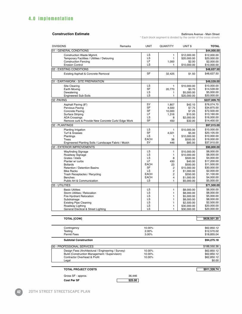
Construction Estimate Baltimore Avenue - Main Street* Each block segment is divided by the center of the cross streets
DIVISIONS Remarks UNIT QUANTITY UNIT $ TOTAL01 - GENERAL CONDITIONS $44,000.00
Construction Waste Mgmnt. LS 1 $12,000.00 $12,000.00Temporary Facilities / Utilities / Detouring LS 1 $20,000.00 $20,000.00Construction Fencing LF 1,000 $2.00 $2,000.00Erosion Control LS 1 $10,000.00 $10,000.00
02 - EXISTING CONDITIONS $48,637.50Existing Asphalt & Concrete Removal SF 32,425 $1.50 $48,637.50
31 - EARTHWORK - SITE PREPARATION $49,539.00Site Clearing LS 1 $10,000.00 $10,000.00Earth Moving SF 20,770 $0.70 $14,539.00Dewatering LS 1 $5,000.00 $5,000.00Engineered Sub-Soils LS 1 $20,000.00 $20,000.00
32 -PAVING $227,009.70Asphalt Paving (8") SY 1,807 $42.10 $76,074.70Pervious Paving SF 4,500 $7.75 $34,875.00Concrete Paving SF 10,000 $7.25 $72,500.00Surface Striping LF 1,316 $10.00 $13,160.00ADA Crossings LS 8 $2,000.00 $16,000.00Remove curb & Provide New Concrete Curb/ Edge Work SF 450 $32.00 $14,400.00
32 - PLANTINGS $97,015.00Planting Irrigation LS 1 $10,000.00 $10,000.00Turf & Grasses SF 4,021 $5.00 $20,105.00Plantings LS 1 $10,000.00 $10,000.00Trees EACH 38 $500.00 $19,000.00Engineered Planting Soils / Landscape Fabric / Mulch SY 446 $85.00 $37,910.00
32 - EXTERIOR IMPROVEMENTS $90,800.00Wayfinding Signage LS 1 $10,000.00 $8,000.00Roadway Signage LS 1 $10,000.00 $8,000.00Grates / Inlets LS 8 $500.00 $4,000.00Planter w/ curbs LF 430 $40.00 $17,200.00Bollards EACH 23 $500.00 $11,500.00Retention / Detention Basins SF 2 $15,000.00 $30,000.00Bike Racks LS 2 $1,000.00 $2,000.00Trash Receptacles / Recycling EACH 2 $550.00 $1,100.00Benches EACH 4 $1,000.00 $4,000.00Public Art & Communication LS 1 $5,000.00 $5,000.00
33 - UTILITIES $71,500.00Basic Utilities LS 1 $8,000.00 $8,000.00Storm Utilities / Relocation LS 1 $8,000.00 $8,000.00Fire Hyrdrant Relocation LS 1 $5,000.00 $5,000.00Subdrainage LS 1 $8,000.00 $8,000.00Existing Pipe Cleaning LS 1 $2,500.00 $2,500.00Roadway Ligthing LS 1 $30,000.00 $20,000.00General Electical & Street Lighting LS 1 $30,000.00 $20,000.00
TOTAL [COW] $628,501.20
Contingency 10.00% $62,850.12Testing 2.00% $12,570.02Permit Fees 3.00% $18,855.04
Subtotal Construction $94,275.18
00 - PROFESSIONAL SERVICES $188,550.36Design Fees (Architectural / Engineering / Survey) 10.00% $62,850.12Build (Construction Management / Supervision) 10.00% $62,850.12Contractor Overhead & Profit 10.00% $62,850.12Legal $0.00
TOTAL PROJECT COSTS $911,326.74
Gross SF - approx. 36,446Cost Per SF $25.00

4 .0 imp lemen ta t i on
43
Construction Estimate Main Street - Walnut Street* Each block segment is divided by the center of the cross streets
DIVISIONS Remarks UNIT QUANTITY UNIT $ TOTAL01 - GENERAL CONDITIONS $47,000.00
Construction Waste Mgmnt. LS 1 $15,000.00 $15,000.00Temporary Facilities / Utilities / Detouring LS 1 $20,000.00 $20,000.00Construction Fencing LF 1,000 $2.00 $2,000.00Erosion Control LS 1 $10,000.00 $10,000.00
02 - EXISTING CONDITIONS $292,894.00Existing Asphalt & Concrete Removal SF 28,596 $1.50 $42,894.00
* Demolition of "Flyway" LS 1 $250,000.00 $250,000.0031 - EARTHWORK - SITE PREPARATION $53,309.80
Site Clearing LS 1 $10,000.00 $10,000.00Earth Moving SF 19,014 $0.70 $13,309.80Dewatering LS 1 $5,000.00 $5,000.00Engineered Sub-Soils LS 1 $25,000.00 $25,000.00
32 -PAVING $215,457.80Asphalt Paving (8") SY 1,623 $42.10 $68,328.30Pervious Paving SF 4,400 $7.75 $34,100.00Concrete Paving SF 9,582 $7.25 $69,469.50Surface Striping LF 1,316 $10.00 $13,160.00ADA Crossings LS 8 $2,000.00 $16,000.00Remove curb & Provide New Concrete Curb/ Edge Work SF 450 $32.00 $14,400.00
32 - PLANTINGS $90,150.00Planting Irrigation LS 1 $10,000.00 $10,000.00Turf & Grasses SF 3,645 $5.00 $18,225.00Plantings LS 1 $10,000.00 $10,000.00Trees EACH 35 $500.00 $17,500.00Engineered Planting Soils / Landscape Fabric / Mulch SY 405 $85.00 $34,425.00
32 - EXTERIOR IMPROVEMENTS $89,100.00Wayfinding Signage LS 1 $10,000.00 $8,000.00Roadway Signage LS 1 $10,000.00 $8,000.00Grates / Inlets LS 8 $500.00 $4,000.00Planter w/ curbs LF 350 $40.00 $14,000.00Bollards EACH 26 $500.00 $13,000.00Retention / Detention Basins SF 2 $15,000.00 $30,000.00Bike Racks LS 2 $1,000.00 $2,000.00Trash Receptacles / Recycling EACH 2 $550.00 $1,100.00Benches EACH 4 $1,000.00 $4,000.00Public Art & Communication LS 1 $5,000.00 $5,000.00
33 - UTILITIES $71,500.00Basic Utilities LS 1 $8,000.00 $8,000.00Storm Utilities / Relocation LS 1 $8,000.00 $8,000.00Fire Hyrdrant Relocation LS 1 $5,000.00 $5,000.00Subdrainage LS 1 $8,000.00 $8,000.00Existing Pipe Cleaning LS 1 $2,500.00 $2,500.00Roadway Ligthing LS 1 $30,000.00 $20,000.00General Electical & Street Lighting LS 1 $30,000.00 $20,000.00
TOTAL [COW] $859,411.60
Contingency 10.00% $85,941.16Testing 2.00% $17,188.23Permit Fees 3.00% $25,782.35
Subtotal Construction $128,911.74
00 - PROFESSIONAL SERVICES $267,823.48Design Fees (Architectural / Engineering / Survey) 10.00% $85,941.16Build (Construction Management / Supervision) 10.00% $85,941.16Contractor Overhead & Profit 10.00% $85,941.16Legal $10,000.00
TOTAL PROJECT COSTS $1,256,146.82
Gross SF - approx. 32,241Cost Per SF $38.96

4 .0 imp lemen ta t i on
44 20th street streetsCape plan
Construction Estimate Walnut Street - Grand Blvd* Each block segment is divided by the center of the cross streets
DIVISIONS Remarks UNIT QUANTITY UNIT $ TOTAL01 - GENERAL CONDITIONS $44,000.00
Construction Waste Mgmnt. LS 1 $12,000.00 $12,000.00Temporary Facilities / Utilities / Detouring LS 1 $20,000.00 $20,000.00Construction Fencing LF 1,000 $2.00 $2,000.00Erosion Control LS 1 $10,000.00 $10,000.00
02 - EXISTING CONDITIONS $47,379.00Existing Asphalt & Concrete Removal SF 31,586 $1.50 $47,379.00
$0.0031 - EARTHWORK - SITE PREPARATION $49,004.20
Site Clearing LS 1 $10,000.00 $10,000.00Earth Moving SF 20,006 $0.70 $14,004.20Dewatering LS 1 $5,000.00 $5,000.00Engineered Sub-Soils LS 1 $20,000.00 $20,000.00
32 -PAVING $233,656.40Asphalt Paving (8") SY 1,734 $42.10 $73,001.40Pervious Paving SF 4,400 $7.75 $34,100.00Concrete Paving SF 11,580 $7.25 $83,955.00Surface Striping LF 1,316 $10.00 $13,160.00ADA Crossings LS 8 $2,000.00 $16,000.00Remove curb & Provide New Concrete Curb/ Edge Work SF 420 $32.00 $13,440.00
32 - PLANTINGS $84,445.00Planting Irrigation LS 1 $10,000.00 $10,000.00Turf & Grasses SF 3,220 $5.00 $16,100.00Plantings LS 1 $10,000.00 $10,000.00Trees EACH 36 $500.00 $18,000.00Engineered Planting Soils / Landscape Fabric / Mulch SY 357 $85.00 $30,345.00
32 - EXTERIOR IMPROVEMENTS $87,700.00Wayfinding Signage LS 1 $10,000.00 $8,000.00Roadway Signage LS 1 $10,000.00 $8,000.00Grates / Inlets LS 8 $500.00 $4,000.00Planter w/ curbs LF 315 $40.00 $12,600.00Bollards EACH 26 $500.00 $13,000.00Retention / Detention Basins SF 2 $15,000.00 $30,000.00Bike Racks LS 2 $1,000.00 $2,000.00Trash Receptacles / Recycling EACH 2 $550.00 $1,100.00Benches EACH 4 $1,000.00 $4,000.00Public Art & Communication LS 1 $5,000.00 $5,000.00
33 - UTILITIES $71,500.00Basic Utilities LS 1 $8,000.00 $8,000.00Storm Utilities / Relocation LS 1 $8,000.00 $8,000.00Fire Hyrdrant Relocation LS 1 $5,000.00 $5,000.00Subdrainage LS 1 $8,000.00 $8,000.00Existing Pipe Cleaning LS 1 $2,500.00 $2,500.00Roadway Ligthing LS 1 $30,000.00 $20,000.00General Electical & Street Lighting LS 1 $30,000.00 $20,000.00
TOTAL [COW] $570,305.60
Contingency 10.00% $57,030.56Testing 2.00% $11,406.11Permit Fees 3.00% $17,109.17
Subtotal Construction $85,545.84
00 - PROFESSIONAL SERVICES $171,091.68Design Fees (Architectural / Engineering / Survey) 10.00% $57,030.56Build (Construction Management / Supervision) 10.00% $57,030.56Contractor Overhead & Profit 10.00% $57,030.56Legal $0.00
TOTAL PROJECT COSTS $826,943.12
Gross SF - approx. 34,806Cost Per SF $23.76

4 .0 imp lemen ta t i on
45
Construction Estimate Walnut Street - Grand Blvd* Each block segment is divided by the center of the cross streets
DIVISIONS Remarks UNIT QUANTITY UNIT $ TOTAL01 - GENERAL CONDITIONS $44,000.00
Construction Waste Mgmnt. LS 1 $12,000.00 $12,000.00Temporary Facilities / Utilities / Detouring LS 1 $20,000.00 $20,000.00Construction Fencing LF 1,000 $2.00 $2,000.00Erosion Control LS 1 $10,000.00 $10,000.00
02 - EXISTING CONDITIONS $47,379.00Existing Asphalt & Concrete Removal SF 31,586 $1.50 $47,379.00
$0.0031 - EARTHWORK - SITE PREPARATION $49,004.20
Site Clearing LS 1 $10,000.00 $10,000.00Earth Moving SF 20,006 $0.70 $14,004.20Dewatering LS 1 $5,000.00 $5,000.00Engineered Sub-Soils LS 1 $20,000.00 $20,000.00
32 -PAVING $233,656.40Asphalt Paving (8") SY 1,734 $42.10 $73,001.40Pervious Paving SF 4,400 $7.75 $34,100.00Concrete Paving SF 11,580 $7.25 $83,955.00Surface Striping LF 1,316 $10.00 $13,160.00ADA Crossings LS 8 $2,000.00 $16,000.00Remove curb & Provide New Concrete Curb/ Edge Work SF 420 $32.00 $13,440.00
32 - PLANTINGS $84,445.00Planting Irrigation LS 1 $10,000.00 $10,000.00Turf & Grasses SF 3,220 $5.00 $16,100.00Plantings LS 1 $10,000.00 $10,000.00Trees EACH 36 $500.00 $18,000.00Engineered Planting Soils / Landscape Fabric / Mulch SY 357 $85.00 $30,345.00
32 - EXTERIOR IMPROVEMENTS $87,700.00Wayfinding Signage LS 1 $10,000.00 $8,000.00Roadway Signage LS 1 $10,000.00 $8,000.00Grates / Inlets LS 8 $500.00 $4,000.00Planter w/ curbs LF 315 $40.00 $12,600.00Bollards EACH 26 $500.00 $13,000.00Retention / Detention Basins SF 2 $15,000.00 $30,000.00Bike Racks LS 2 $1,000.00 $2,000.00Trash Receptacles / Recycling EACH 2 $550.00 $1,100.00Benches EACH 4 $1,000.00 $4,000.00Public Art & Communication LS 1 $5,000.00 $5,000.00
33 - UTILITIES $71,500.00Basic Utilities LS 1 $8,000.00 $8,000.00Storm Utilities / Relocation LS 1 $8,000.00 $8,000.00Fire Hyrdrant Relocation LS 1 $5,000.00 $5,000.00Subdrainage LS 1 $8,000.00 $8,000.00Existing Pipe Cleaning LS 1 $2,500.00 $2,500.00Roadway Ligthing LS 1 $30,000.00 $20,000.00General Electical & Street Lighting LS 1 $30,000.00 $20,000.00
TOTAL [COW] $570,305.60
Contingency 10.00% $57,030.56Testing 2.00% $11,406.11Permit Fees 3.00% $17,109.17
Subtotal Construction $85,545.84
00 - PROFESSIONAL SERVICES $171,091.68Design Fees (Architectural / Engineering / Survey) 10.00% $57,030.56Build (Construction Management / Supervision) 10.00% $57,030.56Contractor Overhead & Profit 10.00% $57,030.56Legal $0.00
TOTAL PROJECT COSTS $826,943.12
Gross SF - approx. 34,806Cost Per SF $23.76
Construction Estimate Grand Blvd - McGee Street* Each block segment is divided by the center of the cross streets
DIVISIONS Remarks UNIT QUANTITY UNIT $ TOTAL01 - GENERAL CONDITIONS $44,000.00
Construction Waste Mgmnt. LS 1 $12,000.00 $12,000.00Temporary Facilities / Utilities / Detouring LS 1 $20,000.00 $20,000.00Construction Fencing LF 1,000 $2.00 $2,000.00Erosion Control LS 1 $10,000.00 $10,000.00
02 - EXISTING CONDITIONS $44,901.00Existing Asphalt & Concrete Removal SF 29,934 $1.50 $44,901.00
$0.0031 - EARTHWORK - SITE PREPARATION $48,409.20
Site Clearing LS 1 $10,000.00 $10,000.00Earth Moving SF 19,156 $0.70 $13,409.20Dewatering LS 1 $5,000.00 $5,000.00Engineered Sub-Soils LS 1 $20,000.00 $20,000.00
32 -PAVING $223,561.50Asphalt Paving (8") SY 1,685 $42.10 $70,938.50Pervious Paving SF 3,990 $7.75 $30,922.50Concrete Paving SF 10,778 $7.25 $78,140.50Surface Striping LF 1,316 $10.00 $13,160.00ADA Crossings LS 8 $2,000.00 $16,000.00Remove curb & Provide New Concrete Curb/ Edge Work SF 450 $32.00 $14,400.00
32 - PLANTINGS $100,050.00Planting Irrigation LS 1 $10,000.00 $10,000.00Turf & Grasses SF 4,092 $5.00 $20,460.00Plantings LS 1 $10,000.00 $10,000.00Trees EACH 42 $500.00 $21,000.00Engineered Planting Soils / Landscape Fabric / Mulch SY 454 $85.00 $38,590.00
32 - EXTERIOR IMPROVEMENTS $92,300.00Wayfinding Signage LS 1 $10,000.00 $8,000.00Roadway Signage LS 1 $10,000.00 $8,000.00Grates / Inlets LS 8 $500.00 $4,000.00Planter w/ curbs LF 430 $40.00 $17,200.00Bollards EACH 26 $500.00 $13,000.00Retention / Detention Basins SF 2 $15,000.00 $30,000.00Bike Racks LS 2 $1,000.00 $2,000.00Trash Receptacles / Recycling EACH 2 $550.00 $1,100.00Benches EACH 4 $1,000.00 $4,000.00Public Art & Communication LS 1 $5,000.00 $5,000.00
33 - UTILITIES $71,500.00Basic Utilities LS 1 $8,000.00 $8,000.00Storm Utilities / Relocation LS 1 $8,000.00 $8,000.00Fire Hyrdrant Relocation LS 1 $5,000.00 $5,000.00Subdrainage LS 1 $8,000.00 $8,000.00Existing Pipe Cleaning LS 1 $2,500.00 $2,500.00Roadway Ligthing LS 1 $30,000.00 $20,000.00General Electical & Street Lighting LS 1 $30,000.00 $20,000.00
TOTAL [COW] $579,820.70
Contingency 10.00% $57,982.07Testing 2.00% $11,596.41Permit Fees 3.00% $17,394.62
Subtotal Construction $86,973.11
00 - PROFESSIONAL SERVICES $173,946.21Design Fees (Architectural / Engineering / Survey) 10.00% $57,982.07Build (Construction Management / Supervision) 10.00% $57,982.07Contractor Overhead & Profit 10.00% $57,982.07Legal $0.00
TOTAL PROJECT COSTS $840,740.02
Gross SF - approx. 34,026Cost Per SF $24.71

4 .0 imp lemen ta t i on
46 20th street streetsCape plan
parking meters
4.3 Funding Opportunities
Advocating for future funding is the responsibility of the three neighborhoods impacted by the 20th
Street Streetscape Plan – the Crossroads Arts District, the Westside, and the Downtown Loop, with
the assistance of the City of Kansas City, Missouri. Depending on funding opportunities, some of the
recommended phases may be split into smaller projects or combined into larger projects than are
defined here. Funding for these phases may come from a variety of local, state or federal sources
including:
• SurfaceTransportationProgram–TransportationEnhancementFunds(STP-TE)
• MidAmericaRegionalCouncilSustainableCommunitiesInitiative/HUDGrant
• FederalHighwayAdministration
• FederalHighwayAdministrationCongestionMitigationandAirQualityImprovementProgram
(CMAQ)
• AmericanReinvestmentandRecoveryActFunding(ARRA)
• TaxIncrementFinancingFunds(TIF)
• KansasCity,MissouriCapitalImprovementsProgram(CIP)
• CommunityImprovementDistrictFunds(CID)
• NeighborhoodImprovementDistrictFunds(NID)
• PubicImprovementAdvisoryCommittee(PIAC)
• FundingthroughpartnershipwithKCMOCityPlanningandDevelopment
• FundingthroughpartnershipwithKCMOParksandRecreationDepartment
• FundingthroughpartnershipwithKCMOWaterDepartment
• FundingthroughpartnershipwithKCMOPublicWorksDepartment
• FundingthroughpartnershipwithMid-AmericaRegionalCouncil(MARC)
• Privatefundingforimprovementsonprivateproperty.
Maintenance
Implementation of the 20th Street Streetscape Plan is dependent upon the successful creation of
the Crossroads Community Improvement District (CID), working in close collaboration with various
city agencies. The Crossroads CID, anticipated to be voted on in the Summer of 2011, will establish
an agreement for the maintenance of streetscape improvements that exceed the City standard. The
improvements typically include street trees, stormwater BMP’s, pedestrian lights and amenities.