2016 state of indiana fire weather area operating plan
TRANSCRIPT

1
2017 State of Indiana
Fire Weather Area Operating Plan
Last Updated: April 18, 2017
2
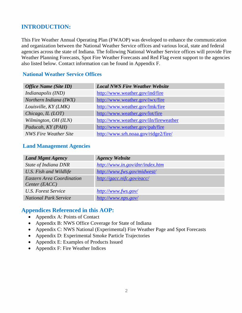
INTRODUCTION:
This Fire Weather Annual Operating Plan (FWAOP) was developed to enhance the communication
and organization between the National Weather Service offices and various local, state and federal
agencies across the state of Indiana. The following National Weather Service offices will provide Fire
Weather Planning Forecasts, Spot Fire Weather Forecasts and Red Flag event support to the agencies
also listed below. Contact information can be found in Appendix F.
National Weather Service Offices
Office Name (Site ID) Local NWS Fire Weather Website
Indianapolis (IND) http://www.weather.gov/ind/fire
Northern Indiana (IWX) http://www.weather.gov/iwx/fire
Louisville, KY (LMK) http://www.weather.gov/lmk/fire
Chicago, IL (LOT) http://www.weather,gov/lot/fire
Wilmington, OH (ILN) http://www.weather.gov/iln/fireweather
Paducah, KY (PAH) http://www.weather.gov/pah/fire
NWS Fire Weather Site http://www.srh.noaa.gov/ridge2/fire/
Land Management Agencies
Land Mgmt Agency Agency Website
State of Indiana DNR http://www.in.gov/dnr/index.htm
U.S. Fish and Wildlife http://www.fws.gov/midwest/
Eastern Area Coordination
Center (EACC)
http://gacc.nifc.gov/eacc/
U.S. Forest Service http://www.fws.gov/
National Park Service http://www.nps.gov/
Appendices Referenced in this AOP: Appendix A: Points of Contact
Appendix B: NWS Office Coverage for State of Indiana
Appendix C: NWS National (Experimental) Fire Weather Page and Spot Forecasts
Appendix D: Experimental Smoke Particle Trajectories
Appendix E: Examples of Products Issued
Appendix F: Fire Weather Indices
3
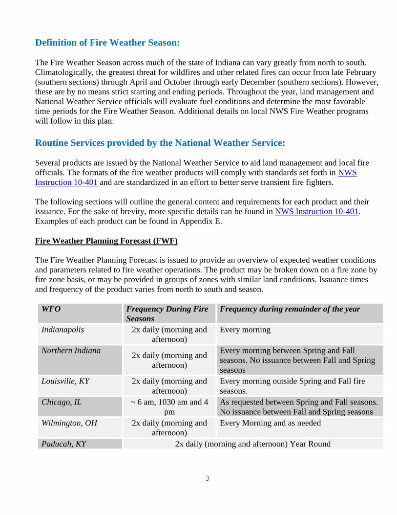
Definition of Fire Weather Season:
The Fire Weather Season across much of the state of Indiana can vary greatly from north to south.
Climatologically, the greatest threat for wildfires and other related fires can occur from late February
(southern sections) through April and October through early December (southern sections). However,
these are by no means strict starting and ending periods. Throughout the year, land management and
National Weather Service officials will evaluate fuel conditions and determine the most favorable
time periods for the Fire Weather Season. Additional details on local NWS Fire Weather programs
will follow in this plan.
Routine Services provided by the National Weather Service:
Several products are issued by the National Weather Service to aid land management and local fire
officials. The formats of the fire weather products will comply with standards set forth in NWS
Instruction 10-401 and are standardized in an effort to better serve transient fire fighters.
The following sections will outline the general content and requirements for each product and their
issuance. For the sake of brevity, more specific details can be found in NWS Instruction 10-401.
Examples of each product can be found in Appendix E.
Fire Weather Planning Forecast (FWF)
The Fire Weather Planning Forecast is issued to provide an overview of expected weather conditions
and parameters related to fire weather operations. The product may be broken down on a fire zone by
fire zone basis, or may be provided in groups of zones with similar land conditions. Issuance times
and frequency of the product varies from north to south and season.
WFO Frequency During Fire
Seasons
Frequency during remainder of the year
Indianapolis 2x daily (morning and
afternoon)
Every morning
Northern Indiana 2x daily (morning and
afternoon)
Every morning between Spring and Fall
seasons. No issuance between Fall and Spring
seasons
Louisville, KY 2x daily (morning and
afternoon)
Every morning outside Spring and Fall fire
seasons.
Chicago, IL ~ 6 am, 1030 am and 4
pm
As requested between Spring and Fall seasons.
No issuance between Fall and Spring seasons
Wilmington, OH 2x daily (morning and
afternoon)
Every Morning and as needed
Paducah, KY 2x daily (morning and afternoon) Year Round

4
The morning forecast will contain three periods and an extended portion, while the afternoon forecast
will contain four periods and an extended forecast.
The forecasts will contain the following elements:
Headline - If a Red Flag Warning or Fire Weather Watch is in effect, a headline is mandatory.
Outside of these conditions, headlines may be used to convey concerns about significant
trends, but are not required.
Discussion – This is a short paragraph outlining the synoptic features affecting the forecast
area during the next 24 to 36 hours.
Forecast elements will include: cloud cover, chance and type of precipitation, precipitation
amount, max and min temperatures and its trend, max and min relative humidity and its trend,
20-foot winds in MPH, mixing height in 1000’s of feet, and transport winds in knots.
Extended forecast will be appended to the end of the tabular part of the product and will
include the winds through day 7.
The following optional forecast elements may be included in gridded data and transmitted in text
products at the request of local users. Detailed descriptions of these elements are located in Appendix
F.
Haines Index
Ventilation Index (VI)
Davis Stability Index (DSI)
Superfog Indicator (LVORI)
Atmospheric Dispersion (ADI)
This forecast will be updated whenever the following conditions are warranted.
A Fire Weather Watch is issued, cancelled or expired
A Red Flag Warning is issued, cancelled or expired
When forecast elements are deemed unrepresentative
NFDRS (Point) Forecast
The Point Forecast is issued for a specific point within the fire weather area of responsibility (see
stations below) and is valid for a twenty-four (24) hour period after issuance. The format for NFDRS
forecast is found in NWS Instruction 10-401.
The following are the points forecasted for during the regular fire weather season.
Station Name Station Number Issuance Time and Frequency NWS Office Issuing
Tipsaw 128905 ~ 330 pm EST during Fire Season Louisville
Hardin Ridge 125701 ~ 330 pm EST during Fire Season Indianapolis
Big Oaks 127301 Upon request during Fire Season Wilmington, OH
Bailey 120201 ~ 1 pm LST during Fire Season Chicago, IL

5
No NFDRS Sites in the State of
Indiana
Paducah
Northern Indiana
Spot Forecasts (FWS)- Site-specific forecasts (Spot) are issued by an NWS office in support of wildfire and natural resource
management. These forecasts aid the land management and fire control agencies in protecting life and
property during wildfires, fuel reduction burns, and rehabilitation and restoration of natural resources.
Spot forecasts may also be issued for a threat to public safety, including but not limited to hazardous
materials incidents, marine incidents, and search and rescue response. However, this plan will focus
primarily on forecasts in support of land management agencies.
The forecast elements will typically consist of the highest or lowest temperature during the period,
the highest or lowest relative humidity, wind direction and speed, chances and duration of
precipitation. Directions for requesting Spot Forecasts can be found in Appendix C.
Experimental Model Particle Trajectories
Land management agencies that have a wildfire of 100 acres or greater, or are conducting a
prescribed burn of 100 acres or greater, may request that the National Weather Service run the
NOAA Air Resources Laboratory dispersion model, HYSPLIT, to model particle trajectory. This
model is a combination of the U.S. Forest Service’s Blue Sky Model and meteorological models used
by NWS Forecasters. This data is output in a graphical form and is considered experimental since it is
relatively new, and only limited testing has been conducted thus far. This data can be used in addition
to a typical spot forecast that is used for Prescribed Burns and Wildfires. More information on the
procedures for requesting this and how to interpret the data can be found in Appendix D at the end of
this AOP.
Urgent Fire Weather Messages
Fire Weather Watches and Red Flag Warnings (RFW)-
A Fire Weather Watch or Red Flag Warning event occurs whenever extremely dry fuels combine
with critical weather parameters to create an atmosphere that could contribute to extensive wildfires
with the potential to threaten life and property. Coordination should take place with the affected land
management agency for the zone(s) where the watch or warning is being considered. A watch is
issued typically up to 96 hour in advance of an event and a warning within 48 hours. A Red Flag
warning may also be requested by a land management agency, if they feel that due to extreme dryness
in the forest, that wildfires are likely. The Fire Weather Watch or Red Flag Warning can be issued on
a county by county basis. The land management agencies and the NWS offices will discuss the area
that will be contained within the urgent fire weather message.
The following criteria will be used to determine if Red Flag conditions exist:
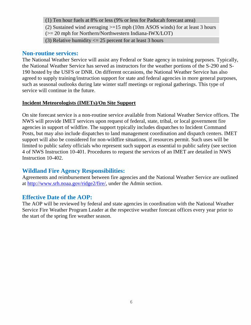
6
(1) Ten hour fuels at 8% or less (9% or less for Paducah forecast area)
(2) Sustained wind averaging >=15 mph (10m ASOS winds) for at least 3 hours
(>= 20 mph for Northern/Northwestern Indiana-IWX/LOT)
(3) Relative humidity <= 25 percent for at least 3 hours
Non-routine services: The National Weather Service will assist any Federal or State agency in training purposes. Typically,
the National Weather Service has served as instructors for the weather portions of the S-290 and S-
190 hosted by the USFS or DNR. On different occasions, the National Weather Service has also
agreed to supply training/instruction support for state and federal agencies in more general purposes,
such as seasonal outlooks during late winter staff meetings or regional gatherings. This type of
service will continue in the future.
Incident Meteorologists (IMETs)/On Site Support
On site forecast service is a non-routine service available from National Weather Service offices. The
NWS will provide IMET services upon request of federal, state, tribal, or local government fire
agencies in support of wildfire. The support typically includes dispatches to Incident Command
Posts, but may also include dispatches to land management coordination and dispatch centers. IMET
support will also be considered for non-wildfire situations, if resources permit. Such uses will be
limited to public safety officials who represent such support as essential to public safety (see section
4 of NWS Instruction 10-401. Procedures to request the services of an IMET are detailed in NWS
Instruction 10-402.
Wildland Fire Agency Responsibilities: Agreements and reimbursement between fire agencies and the National Weather Service are outlined
at http://www.srh.noaa.gov/ridge2/fire/, under the Admin section.
Effective Date of the AOP: The AOP will be reviewed by federal and state agencies in coordination with the National Weather
Service Fire Weather Program Leader at the respective weather forecast offices every year prior to
the start of the spring fire weather season.
7
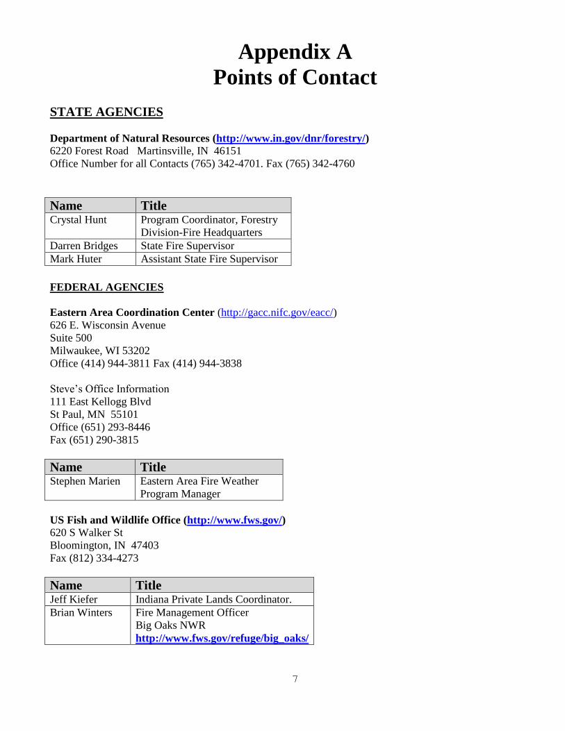
Appendix A
Points of Contact
STATE AGENCIES
Department of Natural Resources (http://www.in.gov/dnr/forestry/)
6220 Forest Road Martinsville, IN 46151
Office Number for all Contacts (765) 342-4701. Fax (765) 342-4760
Name Title Crystal Hunt Program Coordinator, Forestry
Division-Fire Headquarters
Darren Bridges State Fire Supervisor
Mark Huter Assistant State Fire Supervisor
FEDERAL AGENCIES
Eastern Area Coordination Center (http://gacc.nifc.gov/eacc/)
626 E. Wisconsin Avenue
Suite 500
Milwaukee, WI 53202
Office (414) 944-3811 Fax (414) 944-3838
Steve’s Office Information
111 East Kellogg Blvd
St Paul, MN 55101
Office (651) 293-8446
Fax (651) 290-3815
Name Title Stephen Marien Eastern Area Fire Weather
Program Manager
US Fish and Wildlife Office (http://www.fws.gov/)
620 S Walker St
Bloomington, IN 47403
Fax (812) 334-4273
Name Title Jeff Kiefer Indiana Private Lands Coordinator.
Brian Winters Fire Management Officer
Big Oaks NWR
http://www.fws.gov/refuge/big_oaks/
8
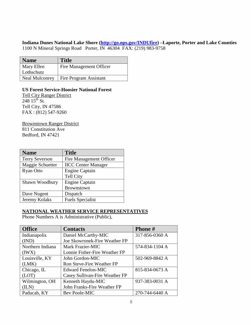
Indiana Dunes National Lake Shore (http://go.nps.gov/INDUfire) –Laporte, Porter and Lake Counties
1100 N Mineral Springs Road Porter, IN 46304 FAX: (219) 983-9758
Name Title Mary Ellen
Lothschutz
Fire Management Officer
Neal Mulconrey Fire Program Assistant
US Forest Service-Hoosier National Forest
Tell City Ranger District
248 15th
St.
Tell City, IN 47586
FAX : (812) 547-9260
Brownstown Ranger District
811 Constitution Ave
Bedford, IN 47421
Name Title Terry Severson Fire Management Officer
Maggie Schuetter IICC Center Manager
Ryan Otto Engine Captain
Tell City
Shawn Woodbury Engine Captain
Brownstown
Dave Nugent Dispatch
Jeremy Kolaks Fuels Specialist
NATIONAL WEATHER SERVICE REPRESENTATIVES
Phone Numbers A is Administrative (Public),
Office Contacts Phone # Indianapolis
(IND)
Daniel McCarthy-MIC
Joe Skowronek-Fire Weather FP
317-856-0360 A
Northern Indiana
(IWX)
Mark Frazier-MIC
Lonnie Fisher-Fire Weather FP 574-834-1104 A
Louisville, KY
(LMK)
John Gordon-MIC
Ron Steve-Fire Weather FP
502-969-8842 A
Chicago, IL
(LOT)
Edward Fenelon-MIC
Casey Sullivan-Fire Weather FP
815-834-0673 A
Wilmington, OH
(ILN)
Kenneth Haydu-MIC
John Franks-Fire Weather FP
937-383-0031 A
Paducah, KY Bev Poole-MIC 270-744-6440 A
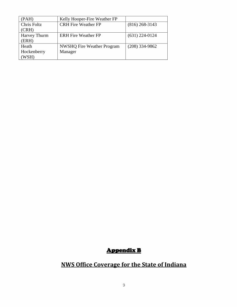
9
(PAH) Kelly Hooper-Fire Weather FP
Chris Foltz
(CRH)
CRH Fire Weather FP (816) 268-3143
Harvey Thurm
(ERH)
ERH Fire Weather FP (631) 224-0124
Heath
Hockenberry
(WSH)
NWSHQ Fire Weather Program
Manager
(208) 334-9862
Appendix B
NWS Office Coverage for the State of Indiana

10
11
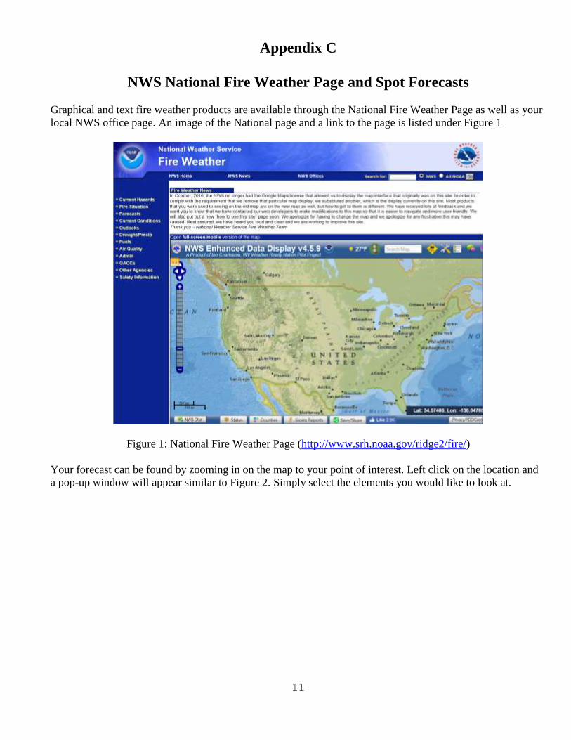
Appendix C
NWS National Fire Weather Page and Spot Forecasts
Graphical and text fire weather products are available through the National Fire Weather Page as well as your
local NWS office page. An image of the National page and a link to the page is listed under Figure 1
Figure 1: National Fire Weather Page (http://www.srh.noaa.gov/ridge2/fire/)
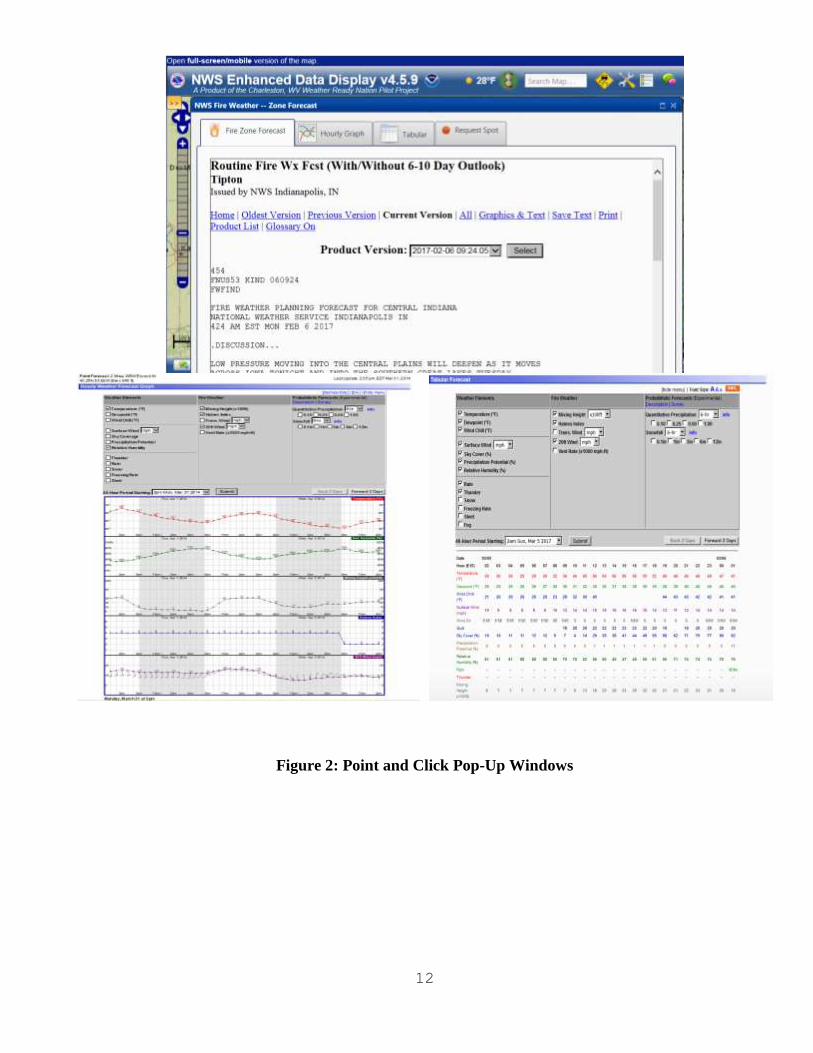
Your forecast can be found by zooming in on the map to your point of interest. Left click on the location and
a pop-up window will appear similar to Figure 2. Simply select the elements you would like to look at.
12
Figure 2: Point and Click Pop-Up Windows

13
Spot Forecast Request Instructions
Instructions for Submitting a Spot Forecast request via the internet Go to the NWS Spot Forecast request page at: http://www.weather.gov/spot/
If desired, zoom in to area of interest, then copy and paste link with lat/long info included for later use
to skip having to zoom
Step 1: Enter in location of spot request using street address (Section A), or via lat/long (Section B), or
moving the pin on the map (Section B)
Step 2: Select type of incident (Usually wildfire or prescribed fire)
Step 3: Click “Generate A Spot Request” button
Enter Spot Forecast Contact Information, Fire Weather Supplemental Information, Forecast
Information, Answer Yes/No to NOAA Hysplit model, Enter observations
Click Submit request
Retrieving the Spot Forecast Monitor the Spot Forecast Monitor page at: http://www.weather.gov/spot/monitor/
A green pin means the request is still being worked on, red pin means spot is completed
The forecast can be retrieved by clicking the specific pin, or clicking the spot on the list below the map
Instructions for completing a non-internet Spot Forecast request Download a spot request form at: http://www.srh.noaa.gov/ridge2/fire/docs/WS_FORM_D_SPOT.pdf
Fax it to the appropriate office at the numbers listed in office contact information
NWS personnel will return it via fax to the contact information given in the request
14
Appendix D
Overview on NOAA HYSPLIT Model

15

16

17
Appendix E
Examples of Fire Weather Products:
Fire Weather Planning Forecast
.DISCUSSION...
The unseasonably warm weather of the last week will come to an
abrupt end Friday evening as a powerful cold front sweeps across the
region. Scattered thunderstorms and the threat for severe weather
will accompany the passage of the front Friday afternoon and
evening. Much colder conditions more typical of late February will
return for the weekend along with the potential for snow showers
late Friday night and Saturday. After a dry Sunday, wet and
unsettled weather will continue through the first half of next week.
INZ062-063-069>071-240915-
Monroe-Brown-Martin-Lawrence-Jackson-
Including the cities of Bloomington, Bedford, and Seymour
324 PM EST Thu Feb 23 2017
.Tonight...
Sky/weather.........Mostly cloudy (70-80 percent).
LAL.................1.
Min temperature.....Around 60.
24 hr trend......4 degrees warmer.
Max humidity........81-90 percent.
24 hr trend......9 percent drier.
Humidity recovery...Excellent.
20-foot winds.......South 5 to 10 mph.
Haines Index........4 or low potential for large plume dominated
fire growth.
Smoke dispersal.....Poor to fair (0-50800 knot-ft).
Mixing height.......0-3400 ft AGL.
Transport winds.....South 10 to 15 mph.
.FRIDAY...
Sky/weather.........Mostly cloudy (75-85 percent). Rain showers
likely and chance of thunderstorms after 1300.
LAL.................1 until 1400, then 2 until 1500, then 3.
Max temperature.....69-75.
24 hr trend......1 degree warmer.
Min humidity........52-61 percent.
24 hr trend......2 percent drier.
20-foot winds.......South 10 to 15 mph.
Haines Index........5 or moderate potential for large plume
dominated fire growth.
Smoke dispersal.....Poor to excellent (7200-189700 knot-ft).
Mixing height.......400-6300 ft AGL.
Transport winds.....Southwest 25 to 30 mph.
.FRIDAY NIGHT...
Sky/weather.........Mostly cloudy (70-80 percent). Rain showers and
chance of thunderstorms until 0100.

18
LAL.................3 until 2300, then 1.
Min temperature.....Around 35.
24 hr trend......25 degrees cooler.
Max humidity........70-81 percent.
24 hr trend......12 percent drier.
Humidity recovery...Excellent.
20-foot winds.......West around 10 mph.
Haines Index........3 or very low potential for large plume
dominated fire growth.
Smoke dispersal.....Poor to excellent (33800-168500 knot-ft).
Mixing height.......1700-5800 ft AGL.
Transport winds.....West around 30 mph.
.SATURDAY...
Sky/weather.........Mostly cloudy (65-75 percent) until 1800, then
mostly sunny (45-55 percent).
LAL.................1.
Max temperature.....Around 40.
24 hr trend......31 degrees cooler.
Min humidity........41-48 percent.
24 hr trend......13 percent drier.
20-foot winds.......West around 10 mph.
Haines Index........3 or very low potential for large plume
dominated fire growth.
Smoke dispersal.....Good to excellent (88600-171200 knot-ft).
Mixing height.......4400-6300 ft AGL.
Transport winds.....West 25 to 30 mph.
$$
.FORECAST DAYS 3 THROUGH 7...
.SATURDAY...Mostly cloudy with showers likely and scattered
thunderstorms. Lows in the mid 30s. Highs around 40. West winds
around 15 mph.
.SUNDAY...Partly cloudy. Lows in the mid 20s. Highs in the lower
40s. West winds around 5 mph.
.MONDAY...Mostly cloudy. Chance of snow showers and showers. Lows
in the lower 30s. Highs in the upper 40s. Southeast winds around
5 mph.
.TUESDAY...Mostly cloudy with chance of showers. Lows in the
upper 30s. Highs in the upper 50s.
.WEDNESDAY...Mostly cloudy. Showers likely. Lows in the mid 40s.
Highs in the mid 50s.
$$
Fire Weather Watch/Red Flag Warning (RFW).
Example of Red Flag Warning ...RED FLAG WARNING IN EFFECT FROM 11 AM TO 9 PM EDT THURSDAY FOR
CRITICAL FIRE DANGER FOR ALL OF CENTRAL INDIANA...
THE NATIONAL WEATHER SERVICE IN INDIANAPOLIS HAS ISSUED A RED
FLAG WARNING FOR CRITICAL FIRE DANGER...WHICH IS IN EFFECT FROM 11 AM TO
9 PM EDT THURSDAY. THE FIRE WEATHER WATCH IS NO LONGER IN EFFECT.
* AFFECTED AREA...FIRE WEATHER ZONE 021 CARROLL...FIRE WEATHER
19
ZONE 028 WARREN...FIRE WEATHER ZONE 029 TIPPECANOE...FIRE
WEATHER ZONE 030 CLINTON...FIRE WEATHER ZONE 031 HOWARD...FIRE
WEATHER ZONE 035 FOUNTAIN...FIRE WEATHER ZONE 036 MONTGOMERY...
FIRE WEATHER ZONE 037 BOONE...FIRE WEATHER ZONE 038 TIPTON...
FIRE WEATHER ZONE 039 HAMILTON...FIRE WEATHER ZONE 040
MADISON...FIRE WEATHER ZONE 041 DELAWARE...FIRE WEATHER ZONE
042 RANDOLPH...FIRE WEATHER ZONE 043 VERMILLION...FIRE WEATHER
ZONE 044 PARKE...FIRE WEATHER ZONE 045 PUTNAM...FIRE WEATHER
ZONE 046 HENDRICKS...FIRE WEATHER ZONE 047 MARION...FIRE
WEATHER ZONE 048 HANCOCK...FIRE WEATHER ZONE 049 HENRY...FIRE
WEATHER ZONE 051 VIGO...FIRE WEATHER ZONE 052 CLAY...FIRE
WEATHER ZONE 053 OWEN...FIRE WEATHER ZONE 054 MORGAN...FIRE
WEATHER ZONE 055 JOHNSON...FIRE WEATHER ZONE 056 SHELBY...FIRE
WEATHER ZONE 057 RUSH...FIRE WEATHER ZONE 060 SULLIVAN...FIRE
WEATHER ZONE 061 GREENE...FIRE WEATHER ZONE 062 MONROE...FIRE
WEATHER ZONE 063 BROWN...FIRE WEATHER ZONE 064 BARTHOLOMEW...
FIRE WEATHER ZONE 065 DECATUR...FIRE WEATHER ZONE 067 KNOX...
FIRE WEATHER ZONE 068 DAVIESS...FIRE WEATHER ZONE 069 MARTIN...
FIRE WEATHER ZONE 070 LAWRENCE...FIRE WEATHER ZONE 071 JACKSON
AND FIRE WEATHER ZONE 072 JENNINGS.
* WINDS...WEST 10 TO 20 MPH WITH GUSTS UP TO 30 MPH.
* TIMING...MID MORNING THURSDAY INTO EARLY THURSDAY EVENING.
* RELATIVE HUMIDITY...AS LOW AS 23 PERCENT.
* TEMPERATURES...90S MOST OF THE TIME BUT MAXIMUM 100 TO 105.
* LIGHTNING...NONE.
* IMPACTS...MOST OF THE COUNTIES IN CENTRAL INDIANA ARE ALREADY
UNDER BURN BANS DUE TO THREAT OF WILDFIRE SPREAD.
PRECAUTIONARY/PREPAREDNESS ACTIONS...
A RED FLAG WARNING MEANS THAT CRITICAL FIRE WEATHER CONDITIONS
ARE EITHER OCCURRING NOW...OR WILL SHORTLY. A COMBINATION OF
STRONG WINDS...LOW RELATIVE HUMIDITY...AND WARM TEMPERATURES WILL
CREATE EXPLOSIVE FIRE GROWTH POTENTIAL.
20
Appendix F
Fire Weather Indices Explanations:
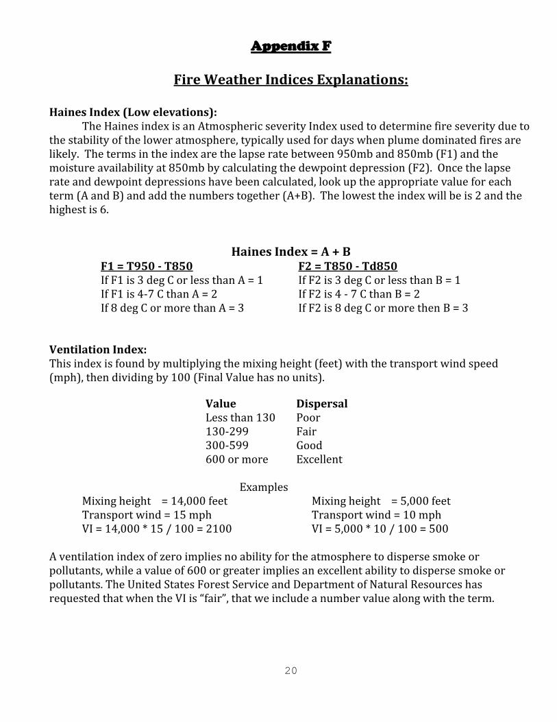
Haines Index (Low elevations):
The Haines index is an Atmospheric severity Index used to determine fire severity due to the stability of the lower atmosphere, typically used for days when plume dominated fires are likely. The terms in the index are the lapse rate between 950mb and 850mb (F1) and the moisture availability at 850mb by calculating the dewpoint depression (F2). Once the lapse rate and dewpoint depressions have been calculated, look up the appropriate value for each term (A and B) and add the numbers together (A+B). The lowest the index will be is 2 and the highest is 6.
Haines Index = A + B F1 = T950 - T850 F2 = T850 - Td850 If F1 is 3 deg C or less than A = 1 If F2 is 3 deg C or less than B = 1 If F1 is 4-7 C than A = 2 If F2 is 4 - 7 C than B = 2 If 8 deg C or more than A = 3 If F2 is 8 deg C or more then B = 3
Ventilation Index: This index is found by multiplying the mixing height (feet) with the transport wind speed (mph), then dividing by 100 (Final Value has no units).
Value Dispersal Less than 130 Poor 130-299 Fair 300-599 Good 600 or more Excellent
Examples Mixing height = 14,000 feet Mixing height = 5,000 feet Transport wind = 15 mph Transport wind = 10 mph VI = 14,000 * 15 / 100 = 2100 VI = 5,000 * 10 / 100 = 500
A ventilation index of zero implies no ability for the atmosphere to disperse smoke or pollutants, while a value of 600 or greater implies an excellent ability to disperse smoke or pollutants. The United States Forest Service and Department of Natural Resources has requested that when the VI is “fair”, that we include a number value along with the term.
21
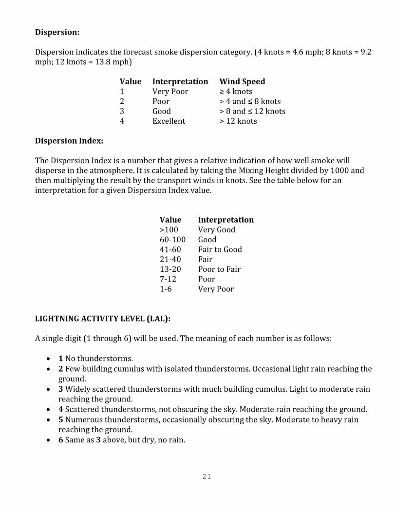
Dispersion: Dispersion indicates the forecast smoke dispersion category. (4 knots = 4.6 mph; 8 knots = 9.2 mph; 12 knots = 13.8 mph)
Value Interpretation Wind Speed 1 Very Poor ≥ 4 knots 2 Poor > 4 and ≤ 8 knots 3 Good > 8 and ≤ 12 knots 4 Excellent > 12 knots
Dispersion Index: The Dispersion Index is a number that gives a relative indication of how well smoke will disperse in the atmosphere. It is calculated by taking the Mixing Height divided by 1000 and then multiplying the result by the transport winds in knots. See the table below for an interpretation for a given Dispersion Index value.
Value Interpretation >100 Very Good 60-100 Good 41-60 Fair to Good 21-40 Fair 13-20 Poor to Fair 7-12 Poor 1-6 Very Poor
LIGHTNING ACTIVITY LEVEL (LAL): A single digit (1 through 6) will be used. The meaning of each number is as follows:
1 No thunderstorms. 2 Few building cumulus with isolated thunderstorms. Occasional light rain reaching the
ground. 3 Widely scattered thunderstorms with much building cumulus. Light to moderate rain
reaching the ground. 4 Scattered thunderstorms, not obscuring the sky. Moderate rain reaching the ground. 5 Numerous thunderstorms, occasionally obscuring the sky. Moderate to heavy rain
reaching the ground. 6 Same as 3 above, but dry, no rain.
22
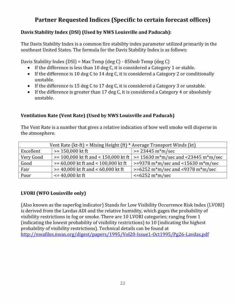
Partner Requested Indices (Specific to certain forecast offices) Davis Stability Index (DSI) (Used by NWS Louisville and Paducah): The Davis Stability Index is a common fire stability index parameter utilized primarily in the southeast United States. The formula for the Davis Stability Index is as follows: Davis Stability Index (DSI) = Max Temp (deg C) - 850mb Temp (deg C)
If the difference is less than 10 deg C, it is considered a Category 1 or stable. If the difference is 10 deg C to 14 deg C, it is considered a Category 2 or conditionally
unstable. If the difference is 15 deg C to 17 deg C, it is considered a Category 3 or unstable. If the difference is greater than 17 deg C, it is considered a Category 4 or absolutely
unstable. Ventilation Rate (Vent Rate) (Used by NWS Louisville and Paducah) The Vent Rate is a number that gives a relative indication of how well smoke will disperse in the atmosphere.
Vent Rate (kt-ft) = Mixing Height (ft) * Average Transport Winds (kt) Excellent >= 150,000 kt ft >= 23445 m*m/sec Very Good >= 100,000 kt ft and < 150,000 kt ft >= 15630 m*m/sec and <23445 m*m/sec Good >= 60,000 kt ft and < 100,000 kt ft >=9378 m*m/sec and <15630 m*m/sec Fair >= 40,000 kt ft and < 60,000 kt ft >=6252 m*m/sec and <9378 m*m/sec Poor <= 40,000 kt ft <=6252 m*m/sec LVORI (WFO Louisville only) (Also known as the superfog indicator) Stands for Low Visibility Occurrence Risk Index (LVORI) is derived from the Lavdas ADI and the relative humidity, which gages the probability of visibility restrictions in fog or smoke. There are 10 LVORI categories; ranging from 1 (indicating the lowest probability of visibility restrictions) to 10 (indicating the highest probability of visibility restrictions). Technical details can be found at http://nwafiles.nwas.org/digest/papers/1995/Vol20-Issue1-Oct1995/Pg26-Lavdas.pdf
23
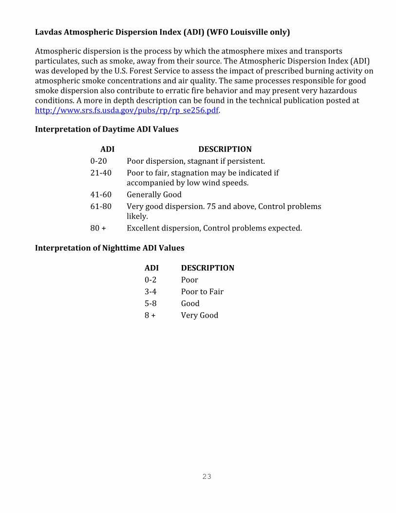
Lavdas Atmospheric Dispersion Index (ADI) (WFO Louisville only)
Atmospheric dispersion is the process by which the atmosphere mixes and transports particulates, such as smoke, away from their source. The Atmospheric Dispersion Index (ADI) was developed by the U.S. Forest Service to assess the impact of prescribed burning activity on atmospheric smoke concentrations and air quality. The same processes responsible for good smoke dispersion also contribute to erratic fire behavior and may present very hazardous conditions. A more in depth description can be found in the technical publication posted at http://www.srs.fs.usda.gov/pubs/rp/rp_se256.pdf.
Interpretation of Daytime ADI Values
ADI DESCRIPTION
0-20 Poor dispersion, stagnant if persistent.
21-40 Poor to fair, stagnation may be indicated if accompanied by low wind speeds.
41-60 Generally Good
61-80 Very good dispersion. 75 and above, Control problems likely.
80 + Excellent dispersion, Control problems expected.
Interpretation of Nighttime ADI Values
ADI DESCRIPTION
0-2 Poor
3-4 Poor to Fair
5-8 Good
8 + Very Good

24