€¦ · · 2016-02-27narrow tors which carry a clear bias favouring the expansion of csg...
TRANSCRIPT


Gloucester-Stroud Valley the Government and the Coal Industry Sep 2011 page 1
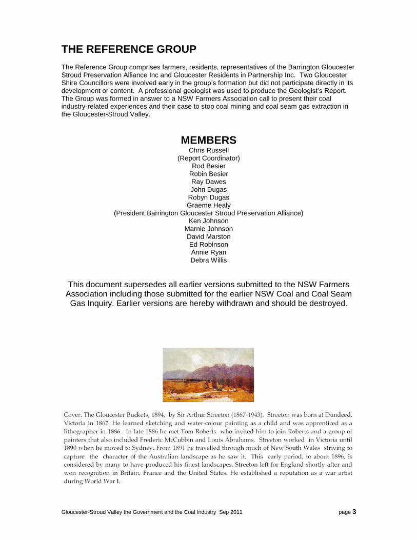
Sir Arthur Streeton, The Gloucester Buckets, 1894
THE GLOUCESTER-STROUD VALLEY,
THE GOVERNMENT AND THE COAL AND COAL SEAM GAS
INDUSTRIES
Submission to the NSW Government‟s Coal Seam Gas Inquiry from the Gloucester Reference Group
supporting the NSW Farmers Association 13th September, 2011
Compiled by the Gloucester Reference Group to assist the NSW Farmers Association Minerals Task Force
in their efforts to achieve real reform in government coal industry decision making to protect Gloucester and other affected rural communities.

Gloucester-Stroud Valley the Government and the Coal Industry Sep 2011 page 2
CONTENTS
Appendices 5-7 „NA‟ indicates that the files are too large to be transmitted electronically. They are
available only in the CD version which has been forwarded by priority mail.
Item Page
Executive Summary 4
Key Recommendations 6
Gloucester-Stroud Valley, The Government And The Coal And Coal Seam Gas Industries
7
Background 7
Bias, Power and Assumptions 10
Current Situation 16
Coal Company Actions 17
Water Air And Health 19
Geology: The Gloucester-Stroud Basin 20
NSW Liberal/National Party Policy 23
Gloucester Council‟s New Approach Document 23
Economic Development Of Gloucester 24
Heritage Of Vale Of Gloucester 26
The Rational Alternative – The Gloucester Project 28
Community Expectations 29
Conclusion 31
Recommendations 32
APPENDICES 38
1 Example of process difficulty EDO‟s Statement 39 2 Health Impacts of Mining in the Gloucester Valley 40 3 Geology Report 43 4 Gloucester Council‟s “New Approach” – An Appraisal Withdrawn 5 Forecasting Surface Winds and Atmospheric Waves NA 6 Heritage: The Gloucester-Stroud Valley NA 7 The Gloucester Project - A Realistic Alternative NA
Gloucester-Stroud Valley the Government and the Coal Industry Sep 2011 page 3
THE REFERENCE GROUP
The Reference Group comprises farmers, residents, representatives of the Barrington Gloucester Stroud Preservation Alliance Inc and Gloucester Residents in Partnership Inc. Two Gloucester Shire Councillors were involved early in the group‟s formation but did not participate directly in its development or content. A professional geologist was used to produce the Geologist‟s Report. The Group was formed in answer to a NSW Farmers Association call to present their coal industry-related experiences and their case to stop coal mining and coal seam gas extraction in the Gloucester-Stroud Valley.
MEMBERS
Chris Russell (Report Coordinator)
Rod Besier Robin Besier Ray Dawes John Dugas
Robyn Dugas Graeme Healy
(President Barrington Gloucester Stroud Preservation Alliance) Ken Johnson
Marnie Johnson David Marston Ed Robinson Annie Ryan Debra Willis
This document supersedes all earlier versions submitted to the NSW Farmers Association including those submitted for the earlier NSW Coal and Coal Seam Gas Inquiry. Earlier versions are hereby withdrawn and should be destroyed.
Gloucester-Stroud Valley the Government and the Coal Industry Sep 2011 page 4
EXECUTIVE SUMMARY We welcome the opportunity to contribute to this inquiry. However, we object to its narrow TORs which carry a clear bias favouring the expansion of CSG industry to the extent possible against compelling alternative arguments for the environment, existing lifestyles and industries, communities, future food, and the permanent damage wrought by this industry. We note too the cumulative effects with other associated fossil fuels industries and mining which together carry massive impacts not addressed in this inquiry. In our submission we outline some of these issues and request that they be fully investigated with evidence supplied by advocates opposed to the current expansions of coal and coal seam gas industries. An issue that permeates all our thinking is that the community is left in limbo. Its opinion, needs, values and long term future are discounted by the current approvals process. Local plans, local industries the environment we live for and live with and our humanity need to be represented in policy processes and at the decision process and given far greater weight in the assessment of individual mining and extraction applications. The community and established industry should not feel forever under siege so that a few people in distant places can make some more money while the government takes a very small fee and the communities carry the unseen costs.
BACKGROUND Gloucester Shire is a thriving community of about 5000 people living predominantly in Gloucester township, and in small villages, estates and farms spread mostly along the Gloucester-Stroud Valley and on to Barrington Village. In the south the Upper Karuah Valley and Stroud are affected by coal mining. In the north nearer Gloucester and overlooking much of the proposed coal developments, the valley is bounded by the Mograni Range and spectacular Bucketts Range. The Shire has enjoyed a long period of natural growth supported by a steady flow of „tree-changers‟ from high population centres. Its scenic beauty, peaceful agriculture, rivers and proximity to Sydney and Newcastle combine to sustain a vibrant tourism industry. These factors and new concerns about water and food security and climate change present it with new opportunities and imperatives to develop environmentally and socially sustainable industries. Unfortunately Gloucester-Stroud Valley contains relatively small isolated seams of coal. Siege Gloucester‟s reputation, environment, agriculture and community aspirations are besieged by:
Existing Gloucester Coal Operations at Stratford (17km from Gloucester) and Duralie
Advancing exploration of Gloucester Coal to within 7Km of Gloucester township
AGL‟s planned 330 gas wells along the valley to Gloucester township and on Barrington
Gloucester Resources Limited exploration up to the residential area of the township itself, and secretive property acquisitions clustered near the Gloucester township including the Industrial Zone, Recreation areas and rural residential areas to the south of Gloucester
property acquisitions clustered near the Gloucester township by GC, GRL and AGL
Existing and newly approved gold explorations
Government and Opposition decisions that dismiss hard facts in preference for coal and its royalties.

Gloucester-Stroud Valley the Government and the Coal Industry Sep 2011 page 5
Causes The underlying causes of these threats are deeply entrenched:
Government abject dependency on coal royalties to the detriment of itself and the state
Government and Industry policy that mining and coal seam gas are critical for state and regional development - irrespective of the social and environmental costs
Government inextricably caught in the coal, coal seam gas, and minerals industry power game
Massive imbalance of power between abandoned communities and the intruding coal companies
Future An important outcome we expect from the current moratorium is a decision that the transition from a state of coal dependency should start now. That should prompt an initial strategy which focuses on:
no new detrimental community impacts
no new environmental degradation
no new agricultural land alienation Such a decision will benefit the Gloucester-Stroud Valley and many others by constraining coal to those areas already severely damaged.
NEW PRINCIPLES FOR MINING APPROVALS PROCESS We seek these principles be applied for any new exploration and mining applications:
Zero Harm to people, communities and the environment
Beneficial Sustainable Coexistence be the new measure of acceptable coexistence
Honesty, complete disclosure and community voice accorded a higher value than that accorded profit motivated overseas or Australian mining companies
The Precautionary Principle be applied in place of the „economic cost of harm minimisation‟
KEY OUTCOMES FOR THE GLOUCESTER STROUD VALLEY The body of this paper presents a compelling case for the continued development of the Gloucester-Stroud Valley as a wholly sustainable economic, social and environmental system. In this respect, we seek specifically these outcomes for the Gloucester–Stroud Valley:
Coal mining and coal seam gas exploitation be subject of a judicial inquiry to establish the system wide costs and benefits of these industries and the extent to which their support and approval is in the state‟s and the nation‟s long term environmental, economic, social, and future industrial interests.
Coal mining and coal seam gas exploitation in Gloucester–Stroud Valley be restricted to current productive mining operations and wound back over the next ten years.
Gloucester-Stroud Valley be recognised as being „climate advantaged‟ under current climate change models – offering the state and the major population centres new food producing potential needed for increasing population, increasing priority applied to food security, and increasing value being applied to abundant high quality water.
This narrow valley be recognised as containing relatively small and isolated coal seams in a very complex geology quite separate the Hunter‟s Coal Chain and the Hunter‟s extensive industrialisation. Fossil fuels based industrialisation of the Gloucester-Stroud Valley would see the permanent loss of this iconic valley for quite questionable state benefit and at an extraordinary cost to communities along the valley and Gloucester itself.

Gloucester-Stroud Valley the Government and the Coal Industry Sep 2011 page 6
Gloucester–Stroud Valley be identified as a vibrant exemplar of enlightened government industrial-social-environmental policy – in recognition of its significant heritage, social and environmental value and its value to the people concentrated in large population centres.
KEY OUTCOMES FOR THE STATE Recognition that NSW is a key supplier and contributor to green house gas emissions and
that it has a valuable and urgent role to play in starting the transition from coal and coal seam gas dependency.
Recognition that the coal and coal seam gas industries have too close a relationship with the state government and are inappropriately involved in policy and strategy making for the state.
Reforms inside Government decision making to end the dependency on these two industries and their power brokers.
KEY RECOMMENDATIONS FOR COAL AND COAL SEAM GAS REFORMS
Reforms are entirely possible to achieve community-valued outcomes. This paper presents a new perspective which we believe should enable a new government to come up with distinctly new policies and decisions. Essentially we seek reforms which demonstrate a new deal for communities, the environment and the future. Like other affected communities, we want government to win back community confidence. This will only be achieved by reform - not „better communication‟. Valued reforms will require: complete policy overhaul, redesign of government processes, excise of the hidden relationships between the government and the coal industries; and acceptance of a far less aggressive role for coal in NSW. Essentially, expansion of coal and gas at the expense of environment, community, existing industries, food and the Gloucester-Stroud Valley must be stopped. The following key recommendations are made. More specific – not lesser – recommendations are listed in the body of this document. KR1: Re-introduce the Coal and Coal Seam Gas Moratorium for 12 months to enable full inquiry and redesign of policy and processes KR2: Adopt mining and coal seam gas policies and supporting legislation that give priority to community, environment and future state strategic needs KR3: Protect the health, well-being, culture and heritage of the community by developing stringent application and approval processes that fully acknowledge community rights KR4: Implement effective policies, practices and enforcement to protect our water security, quality and quantity KR5: Protect and enhance food security, sustainable land and natural resource use KR6: Critically examine the long-term economic benefits argument, methods and assumptions supporting coal industry developments KR7: Desist from over-ruling local government environmental plans that seek to restrict or oppose minerals developments

Gloucester-Stroud Valley the Government and the Coal Industry Sep 2011 page 7
KR8: Critically examine in detail Gloucester-Stroud Valley coal and gas developments KR9: Fully disclose and correct the many systemic/cultural issues in the applications and approvals processes

Gloucester-Stroud Valley the Government and the Coal Industry Sep 2011 page 8
THE GLOUCESTER-STROUD VALLEY, THE GOVERNMENT AND
THE COAL AND COAL SEAM GAS INDUSTRIES
SITUATION REPORT AND RECOMMENDATIONS September 2011
The developments in Gloucester Shire exemplify the nature of problems attached to the current coal and coal seam gas exploration and development processes in NSW. We present here a broader picture than simply those aspects affecting coal seam gas because of the extraordinary and cumulative impacts of large scale extractive industries and attached heavy industry imposed on communities in NSW. We note that government and the industry is currently flying blind – asserting that somehow the imposition of conditions will remove the impacts on people, other industries, amenity, peace, health, food production, water, soils and our long term future.
BACKGROUND Gloucester Shire is a thriving community of about 5000 people living predominantly in Gloucester township, and in small villages, estates and farms spread mostly along the Gloucester-Stroud Valley and on to Barrington Village. Gloucester enjoys a friendly vibrance based on long periods of sustainable land-use and a steady growth in light industries and tourism. The Gloucester-Stroud Valley is a narrow fertile valley stretching roughly north-south. Away from the townships, it consists of Avon River flood plains and undulating country used in the main for

Gloucester-Stroud Valley the Government and the Coal Industry Sep 2011 page 9
cattle industries and lifestyle farming. In the north nearer Gloucester and overlooking the new proposed coal developments, the valley is bounded by the Mograni Range and spectacular Bucketts Range which divides the Gloucester and Barrington Rivers. Here the soils offer long term sustainable farming potential including more intensive, food growing. In the middle to southern end of the valley Gloucester Coal Limited GCL has operated two mines and several pits over the past 20 years in what was initially touted as a five year duration „boutique‟ coal mine. GCL is now seeking to advance north to the boundary of its exploration Licence just 7km from Gloucester. GCL‟s growth in the south, changes in conditions, approvals to discharge contaminated water, wrangling and coercion of local residents, blasting exceedances, continuous noise and traffic have all given the community a feel for what lies ahead should further coal advances be approved. Against this background, the north of the Shire has enjoyed a long period of natural growth supported by a steady flow of „tree-changers‟ from high population centres. The valley‟s scenic beauty, peaceful agriculture, rivers and proximity to Sydney and Newcastle combine to sustain a vibrant tourism industry. They have given Gloucester Shire a reputation which is clean, green and friendly. The agricultural and natural scenery in the drive along the Bucketts Way is an indispensable part of the tourism experience. It forms part of the reason people choose ultimately to live in Gloucester Shire and to put Gloucester on their travel plans. Unfortunately this beautiful Gloucester-Stroud Valley contains isolated relatively small seams of coal. They are not connected to the state‟s major coal seams that form the heavily industrialised, permanently damaged regions of the „Coal Chain‟ in the Hunter and Upper Hunter. Threats to the Gloucester-Stroud Brand Gloucester Shire enjoys a brand – a reputation grown and sustained by the nature of the environment, its uninterrupted green vistas, and the nature of the people it attracts to settle here. That brand, the environment, future agriculture and the aspirations of people who chose this valley as their home valley are threatened by the individual and cumulative effects of:
Advancing exploration of Gloucester Coal to within 7Km of Gloucester past the near empty hamlets of Wards River, Craven and Stratford which are now dominated by Gloucester Coal.
Approval for AGL‟s planned 330 gas wells along the valley and on both sides of Gloucester township.
Rapidly advancing exploration and property acquisition within 1km to 6km of the township by Gloucester Resources Limited.
Existing and newly approved gold exploration.
Government - and Opposition - policies and decisions which have steadfastly ignored, discounted or dismissed community, environment, systemic health issues, sustainable industries and sustainable futures.
Root Causes The underlying causes for these threats are:
Government abject dependency on coal royalties to the detriment of itself and the state
Government inextricably caught in the coal, gas, and minerals industry power game
Resulting massive imbalance of power between the people and the intruding extractive industries.
Coal Industry in the Gloucester-Stroud Valley - Overview The valley‟s modern coal experience extends over three decades. Exploration throughout the valley ultimately delivered its first mine near Stratford village in the mid eighties. This was touted as boutique mine of short duration. Gloucester Coal advised that it would not mine north of Wenham-Cox Road due to proximity to Gloucester township (12Km) and the nature of the coal deposit. A second mine, Gloucester Coal‟s Duralie Mine, opened further south affecting villages like Wards River.

Gloucester-Stroud Valley the Government and the Coal Industry Sep 2011 page 10
The Barrington-Gloucester-Stroud Preservation Alliance, BGSP, opposed Gloucester Coal‟s ventures and have worked at maintaining pressure on Gloucester Coal to meet their environmental and community accountabilities. In December 2008, GRL was discovered to have been secretly buying land near the Gloucester township. Gloucester community rallied in February when 1000 people of the total population of less than 3000 voted unanimously to stop renewal of GRL‟s exploration licences. Following the rally, a second community group Gloucester Residents In Partnership, GRIP, was formed specifically to stop GRL licence renewals and their mining in all three of their licensed areas along the valley. GRL‟s entry and the coal export boom introduced a new set of development opportunities and threats. If GRL were given exploration licence areas up to the fences of Gloucester‟s small residential area, what would stop Gloucester Coal from reneging on its earlier position and advance northward? Given that GRL is a 10% owner of Gloucester Coal and Gloucester Coal retains licence areas up to just 6 km from Gloucester. It seemed that Gloucester Coal was simply biding its time and avoiding the flak meted out to GRL. Indeed, GCL is now expressing interest in exploring north to GRL‟s EL 6523 licence boundary. AGL‟s entry with its exploration licence overlapping Gloucester Coal and GRL, introduced another level of threat and a new dimension to the heavy industrialisation of Gloucester. Gas brought with it notions of greater energy benefits to the state and power generation. It promised no ugly holes, no dust and less intensive heavy industry. But it raised new challenges. Gloucester has perhaps the most unsuitable gas extraction geology in the state - such that the risks of blow-out and gas and water migration between aquifers and the surface are untenable and the costs of failure are high and not correctible. Unfortunately, AGL‟s 330 well development has been approved in concept. Perhaps it is by design, that their PAC approval was rushed just 4 days before the government went into caretaker mode. Regardless, we now discover that AGL‟s approval is now cited in GRL‟s environment assessment as grounds for approval of their phase two exploration drilling – stating that AGL‟s drilling was now a feature of the landscape. We predicted AGL‟s approval would materially assist GRL‟s case in exactly this way. The Government‟s PAC was used to distance the Minister from the approval process because AGL donated to the Labor Party in government. That the PAC is itself „government‟ and uses data, assessments and submissions from the Minister‟s department seems not to matter – a matter of form versus substance … abuse. Inquiry‟s Principles We give our support to the government‟s declared commitment to review CSG industry and to develop a Gloucester strategic plan within 12 months. Our support, however, is conditional upon the Government‟s:
adopting entirely transparent processes,
enabling community input to be favoured input,
distancing itself from its favoured relationship with the coal seam gas industry
enacting these principles: o Zero Harm to people, communities and the environment o Beneficial Sustainable Coexistence adopted as the measure of acceptable
coexistence o Honesty, Complete Disclosure and Community Voice accorded a higher value than
that accorded distant profit motivated coal companies and speculators

Gloucester-Stroud Valley the Government and the Coal Industry Sep 2011 page 11
o The Precautionary Principle and the principles of Ecological Sustainable Development be applied in place of assurances, negotiated „conditions‟, and the company‟s economic assessment of harm minimisation.
We see a solution in which Gloucester is allowed a deciding influence in its strategic planning and land use such that Government and mining interests must seek and work at agreements with the community. We readily acknowledge that government may own the mineral rights to coal. But the government should not presume that „ownership‟ necessarily conveys the right to unfettered damaging access. Nor does it convey the right to decide to compromise community health, well-being, sustainable industry, water supply and quality, lifestyle, relationships and environment. Instead any development to be sponsored by state government must be via a process of negotiation and agreement – not coercion; not the exercise of power. Adoption of these ideas will see a more moderate government, more reasonable coal developments and more vibrant communities.
TERMS OF REFERENCE of this INQUIRY The TORS are clearly biased to enable CSG expansion. They need to be revised to fully accommodate human, social, environmental, food security and community justice factors. They need also to accommodate the fact that CSG is not the solution to our energy or state finances problems.
BIAS, POWER AND ASSUMPTIONS
No presentation of the relationship between communities and government and the coal industries is complete without background on the bias, power and assumptions that deny communities a valued voice. BIAS Coal and CSG bias is evident in government policy processes and decision making:
No strategic view of areas to be protected from mining – not communities, food producing areas, land forms, water, soil, air. All may be harmed in pursuit of coal.
Harm is to be minimised by processes and conditions defined or negotiated by companies.
There is no right to community input to the decision making process prior to exploration areas being defined and no right to comment on the exploration application or approval.
Gloucester has tried to address concerns prior to mining applications only to be rejected by the Minister for Agriculture who was also the Minister for Minerals and Energy. A Council delegation to the Minister headed by the Mayor was rejected two days prior to the meeting when the Minister released a statement specifically dealing with the impending delegation in which he stated that the delegation was wasting its time. He also rejected many letters stating that there was no provision for community input until a mining application had been lodged, assessed and published for comment. Then there would be just 28 days for public comment.
Subsequent Ministers and Premiers have been equally helpful and communicative in dealing with Gloucester‟s representations.
Community Consultative Committees can be established for the exploration phase. So there appears to be a conduit for consultation. But in Gloucester Shire, CCCs have been poorly attended, poorly run, protective of claimed company confidentiality, poorly recorded and unresponsive to community concerns. Complaints concerning company responses and the CCC‟s own performance have been met with entirely unsatisfactory answers.
The fact is that CCCs are not set up to consult. They are set up to drip feed sanitised company information and to stymie community complaints that there is no consultation.

Gloucester-Stroud Valley the Government and the Coal Industry Sep 2011 page 12
POWER IMBALANCE Communities commonly assume they have rights.
They do – until they are tested against the rights of the state to do as it pleases.
They do - until they are confronted by the power of minerals companies, minerals association lobbyists, paid advertisements, political donations and lies.
They do - until exploration licences land like nets without warning.
They do - until the community discovers by chance or rumour that secret land purchases are underway under a variety of company names and no one in government or opposition is even mildly interested. (Minor parties and Independents excepted.)
The major features of the power imbalance however are:
Close collaboration between miners, lobbyists and government which is simply not open to communities.
Unmatchable financial, technical and legal resources while the community relies on raffles and cake stalls to fund a local newsletter.
Paid professional propagandists versus usually retired disparate volunteers with access only to what they can find from media, the internet and other communities.
Government and company experience in defeating a large number of independent community actions versus communities who are usually mounting their first defence or are still fighting their isolated battle.
Government and industry authority over the science and a capability to represent that knowledge to their advantage – commonly by unsubstantiated assertion and/or omission. Amongst the former, the fatuous assertion of coexistence with coal industries is a convenient wisdom amongst undiscerning politicians, bureaucrats and miners. It‟s a convenient lie.
Even this Coal and Coal Seam Gas Inquiry‟s terms of reference and scoping paper are written with the assumption - even assertion - that coal mining and gas extraction will expand massively and that communities will need to move over. ASSUMPTIONS ASSUMPTION 1: “We must mine where the coal seams are” This assumption is presented as an assertion. The facts speak differently. Coal companies take resources where they can do so most profitably. If that means intruding into highly productive agricultural land, or nullifying existing industry, or mining in closely settled areas, or mining beside townships, or damaging lands that rightly should be earmarked for strategic food security, they will do so. They do so because NSW governments have continuously defended and enabled this behaviour. This principal assertion is wrong and can be corrected by the government acknowledging that: 1. where companies mine is a matter of choice:
Firstly, their choice is purely economic and can be distorted by government support/patronage and financial/regulatory regimes.
Secondly, they choose without conscience – the government absolves them of that. Whatever‟s legal can be done.
Thirdly, there are choices – to mine or not to mine; to mine in less closely settled areas: to mine in less significant agricultural areas; to mine further away from communities.
2. a strategic proactive government would define a state strategic water, food, minerals and communities plan. This would give minerals companies assured choices and communities greater certainty. Conscience aside, economic considerations drive companies to mine close to infrastructure and therefore communities. For it is here that infrastructure and transport costs are minimised. Commonly in NSW this is also where high value agricultural and living conditions are found.

Gloucester-Stroud Valley the Government and the Coal Industry Sep 2011 page 13
3. companies avoid the full costs of their choices – by imposing costs as a hidden cost on the community Currently the federal and state health budgets do not show the impact of coal on community health. Attempts to bring this to NSW government attention by concerned health professionals continue to be set aside. In the USA studies have shown massive and directly related health costs attached to coal mining, its industry, and coal fired power stations. Community health should be reason enough for the government to fully adopt the precautionary principle. Undoubtedly, one outcome of this approach may be reduced profit or reduced investment in this industry in NSW. This would act as a greater incentive for companies to invest in cleaner energy alternatives. That transition has to happen at some time. The choice is between transition with company disquiet and upheaval with national consequences. ALTERNATIVE ASSUMPTION 1: The government supports the worth of communities, food security, benign legitimate landuse, and the environment above transient, unsustainable, damaging industries. The NSW Labor government was thrown out last month for a number of reasons. Some Labor leaders suggest it was because they forgot people: “The people didn’t leave us. We left them.” Keneally. Part 3A bears part of the blame. Imperious silent people pursued agendas hidden behind opaque processes designed to deliver more mining against clear opposition from the people. Process design, political practices and outcomes are proof of this. Food Security The best agricultural lands in NSW are now under multiple coal and gas exploration and mining licences. Food security along with water security is becoming a global priority. Unlike coal there is no substitute for food. The concept of food security covers a variety of risks and recognises the central role of food to communities. In NSW food quality and availability are base level assumptions. Good climate, good water, good soils, good transport, efficient committed farmers. However these factors of production are all now suffering some level of compromise or threat:
Good Climate. Our major food production areas along the Murray/Lachlan and Murrumbidgee are now strong candidates to become permanently drought affected or marginal food production areas. Areas forecast to receive good predictable rainfall under climate change need now to be earmarked for that purpose.
Water Security. Water security is primarily about sustaining life and quality of life. It is not primarily about sustaining industry. Water security has two main threats – massively increased local consumption from coal mining and gas extraction which threatens water tables and aquifers and limits that available for communities and farming; and new contamination of catchments enabled by coal mining and gas extraction. Removal of gigalitres of water via dewatering of coal seams cannot happen without consequence. Surface/ground water currently safe from loss to deep reserves is at risk in this highly complex, faulted, geology as deep reserves are pumped out and de-gassed.
Soil Quality. Soil quality in high rainfall agricultural areas is always compromised by mining. Soil structure creates the sponge upon which efficient farming relies. Aquifers are destroyed. They cannot be remediated. Water table must fail. Coal dust is an inevitable part of coal mining. Over a 20-50 year mine life, the top layers of surrounding land and along catchments will be compromised by a layer of coal infused soil. That is, soils and silts containing newly released heavy metals and chemicals dangerous to human and animal health.
Transport. Transport is improved by large project investments. So food transport can benefit from large project investment. Coal ventures could claim, therefore, they deliver some food security benefit in this regard. However the facts are that in NSW coal chooses, to the extent possible, to exploit existing community-developed infrastructure. An alternative

Gloucester-Stroud Valley the Government and the Coal Industry Sep 2011 page 14
proposition that such ventures should foot the whole bill for infrastructure would again see them driven to alternative decisions about what and where to mine – or perhaps even what sort of business they are in.
Efficient Committed Farmers. Farmers in much of NSW are under siege. The NSW Farmers Association called for a moratorium on new coal and gas exploration and developments. They did not seek a stop to existing operations – coal business could continue. Their call was not motivated by objection to coal mining. It was a response to a careless dismissive government intent on grabbing money with any company that paid. Under the previous government, the call for a moratorium, of course, gained no traction. “... We left them.” Keneally. They were abandoned by those who should have defended and championed their interests. Even the Minister for Primary Industries simply didn‟t care. Farmers were under siege – the threat of land acquisition, disruption of their investment plans, disruption of their family life, disruption of their community relationships, constant uncertainty as to whether to move or fight, all distracted them from efficient committed food production. In some cases marital breakdown was another result. Thus, farmers often become oriented to the short term... “Why should I try to improve this...?” “ Why should I worry about ...?”
Under these circumstances commitment to farming is compromised. With water and soils also compromised by mining, farming efficiency is compromised. More inputs are needed to achieve the same output. Reduced efficiency directly impacts food security via price and market forces.
ASSUMPTION 2: Coexistence is a least beneficial Much is made of the notion that Agriculture and mining can co-exist. No government or Minerals Council paper deals deliberately with the nature of such an existence. Would be it be beneficial, benign or detrimental? The message left for the community to infer from the reassurances of coexistence, is that coexistence is at least beneficial. Otherwise it would not be used as a pro-minerals assertion.
EXAMPLE: AGL, in its Gloucester Gas Project, plans to use river water to dilute saline fraccing brine containing trace BTEX and heavy metals and release it on pastures supplying the Manning catchment. 80,000 people and water dependent primary producers are affected. Given a project life of 15-30 years, water security is by definition severely compromised. Once started, that project like all others will argue that regardless of its experience and government/community concerns, it should continue to pollute „to strict conditions‟ because of newly generated employment and income dependencies – and of course its investment in pipelines etc. AGL‟s Gloucester Gas Project has been approved in concept for 330 wells on a predicted high rainfall floodplain and contiguous areas with unspecified means of avoiding pollutants, unspecified fraccing fluids, unknown complexity of geological risks to water loss and contamination, and continuous operation of diesel motors at every well in a closely settled area. Even though AGL has applied in concept for 330 wells, they have refused to declare that further expansions will not be sought. What might have stopped them from seeking approval for 550? This approach of foot in the door – then expand is the common strategy for all coal mining applications reviewed. There is a thriving industry for „modifications and expansions. Once the foot is in the door, the argument‟s centre of interest shifts from community/environment impact to jobs and revenue. Had the full scale and duration been projected at the outset, then community opposition might have made our trusted decision makers somewhat less comfortable.

Gloucester-Stroud Valley the Government and the Coal Industry Sep 2011 page 15
The minerals lobby and the previous government has been keen to talk only about the competing needs of the two industries. It is less useful for them to consider that agriculture, in most instances, necessitates and invites human occupancy of the same area. People live IN agriculture. Agriculture is part of their home, their family, their lifestyle, their community, and their heritage. Others choose to identify with it, choose to live with it, and choose its peace. It should be abundantly clear that cows and crops can‟t share all of a mine site. Coal dust, damaged aquifers, damaged soils, changed water courses, contaminated water - all features of coal mining - militate against benefit being realised by farming. In the longer term the impacts necessarily are more deleterious. There are no examples of beneficial coexistence for agriculture resulting directly from the introduction of coal mining. Occasional reference is made to cattle being grazed on coal mine leases. However, these leases necessarily deny large areas from grazing. The net effects on pre-existing cattle grazing are: reduced carrying capacity; higher inputs; more intensive management; and production of an uncertain product of questionable marketability to an informed public. This is detrimental coexistence. Farming output is not the only consideration in determining the value of coexistence with a coal mining operation. People too are involved. For health reasons and mining operations reasons, they should not live on the site. Unfortunately, they must work there. This is detrimental coexistence. Farmers who choose to continue to graze cattle where the family once lived, must vacate their property with their family and commute to the no longer attractive, no longer valued, no longer owned, land. This is detrimental coexistence. Coal Seam Gas also promotes the coexistence argument. Its argument fails a deliberate analysis for similar reasons: irreversible aquifer damage; risk of loss of ground and surface water; ground water and surface water contamination via brine and fraccing fluids being diluted and discharged onto pastures; large areas of pasture removed from production by wells all weather roads and infrastructure; new watering methods; more intense management methods; reduced flexibility in the development and use of land due buried pipelines; permanently running diesel motors polluting the atmosphere at every well; frequent maintenance traffic; proven risks of gas leaks; loss of scenic values; loss of peace; loss of love and personal investment in the land; loss of land value; heightened family tensions; sense of loss. This is detrimental coexistence. Essentially, the coexistence argument for coal mining is a lie and should be retracted. Coexistence can be beneficial but not between coal and agriculture. The passage of time renders this detrimental form of coexistence more damaging - and recovery becomes the more difficult.
ALTERNATIVE ASSUMPTION 2:
Food Safety. Cattle on or near coal leases must forage in coal dust, on pastures sprayed with contaminated water, drink water unfit for human consumption, and breathe air known to affect human health. For public safety, the beef grown areas surrounding coal mine leases should be presumed unsafe due to their contaminated, unapproved, environments. Cattle and other foodstuffs grown in or near coal mine sites or along contamination flumes should be quarantined until long term animal health and food qualities are independently studied. Regardless of outcome, to enable informed choice, food grown in these areas should not enter the public food chain as anything other than what it is: „coal-related product of NSW‟.
This is detrimental coexistence.
Gloucester-Stroud Valley the Government and the Coal Industry Sep 2011 page 16
Beneficial or benign coexistence is only achievable between industries and groups whose values or interests are shared Coexistence is entirely achievable. There are strong possibilities for renewables energy production units and farming to live in beneficial coexistence. Field mounted solar arrays can create shade and catch water for troughs. Roof mounted solar arrays shade buildings and offer capability to pump water for cattle or drip irrigation. None deny large areas from grazing. None are destructive of any aspect of soil, water or air. All are relatively stable forms offering enduring beneficial coexistence. All offer the opportunity to create new employment in new advancing beneficial technologies. This is beneficial coexistence. ASSUMPTION 3: Land use economics determines the best land use – coal beats agriculture The economic benefits of coal-related industries are used to defeat farming and community opposition. It is convenient to argue the economics of coal versus agriculture. Superficially, the assumption supports coal approvals. But this assumption, like Assumption 2, neatly sidesteps the issue of community. Agriculture based communities – not agriculture - oppose coal. Agricultural landuse is simply one of the factors in a disciplined systematic argument. The government and coal lobby have never openly studied and presented the many hidden costs of the coal industry in NSW. These are just some of the hidden costs of coal and gas:
Massive water consumption and deliberate contamination (via economic minimisation)
Rivers and water storages permanently lost via underground subsidence and cracking
Massively increased exposure to drought due to continuous demand for water, contamination, and loss of water table
Aquifers permanently lost due to damage of geological strata via drilling and mining disturbances
The need for extra resource inputs to chase agricultural productivity on „remediated lands‟
Compromised food security via damage to soil and water availability
Cost of water contamination and continuous treatment
Cost of coal and gas related diseases on community health budget throughout the lives of those affected
Permanent impairment of potential of our children via exposure during childhood development
Loss of species – two local extinctions evident in Werris Creek alone
Loss of peaceful recreation
Roads and infrastructure costs born by community
Concentrations of highly paid transient men in small towns and the social consequences
Loss of employees to mining companies
Increased traffic and continuous noise heavy industry trucks and rail in previously quiet and natural settings
Light emissions destroying the natural night sky.
Loss of community spirit as displaced farmers and retirees are forced to move on and transient populations follow
Increased incidence of children with diseases, disabilities and autism – with consequences for poor schooling and social issues
ALTERNATIVE ASSUMPTION 3: A system-wide view of land use choices and their impacts will determine land use – economics is subordinate to strategic uses A system-wide view will bring a longer time frame and more strategic questions to decision making:
We know that climate change is real and that we must respond to it.
We know that early „transition‟ will reduce the late upheaval of forced change
We know that alternative energy will generate more jobs than we will lose

Gloucester-Stroud Valley the Government and the Coal Industry Sep 2011 page 17
We know that the fossil fuel sector will continue for many years - even if we stopped all new coal mining ventures now
We know that renewables will bring better quality jobs and more diverse opportunities for employment
We know that if we start NOW then we will establish these industries in Australia
We know that if we don‟t start NOW, we will lose opportunities for new strategic industries. They will be taken up overseas.
We know that coal will become uneconomic for Australia to supply. China has fixed its future coal usage as it shifts to nuclear and renewables.
We know that Mongolia‟s massive coal reserves, low costs of production and transport costs will affect Australian coal supplies to China
We know that coal is creating massive imbalances in our skills development, our industry development and social balances
We know that communities are vehemently opposed to coal and gas developments near closely settled areas
We know that there is stark medical and statistical evidence of clusters of coal related diseases in the Hunter
We know that communities should not bear the hidden costs of allowing companies to profit from mining where it is cheapest. Companies need to bear the full costs of their ventures.
CURRENT SITUATION INTRODUCTION In this section documents, evidence, and opinion have been drawn together to outline The Gloucester-Stroud Valley‟s situation regarding its current minerals developments, explorations, concerns and alternatives. We summarise the main factors affecting The Gloucester-Stroud Valley‟s present and future development under the following headings. Coal Company Development And Actions (Example of difficulties – EDO report in Appendix 1) Water Air And Health (Details in Appendix 2) Geology: The Gloucester-Stroud Basin (Detailed report at Appendix 3) Review of NSW Liberal/National Party Policy Critical Review of NSW Coal & Gas Strategy – Scoping Paper Gloucester Council‟s New Approach Document (Analysis in Appendix 4) Precis of a study into the Economic Development Of Gloucester The Heritage Of The Gloucester-Stroud Valley (Full report in Appendix 5 [separate CD]) The Gloucester Project - The Rational Alternative (Presentation at Appendix 6 [separate CD] ) The Appendices amplify much of the content and contain compelling evidence for the preservation of the Gloucester-Stroud Valley as an exemplar of sensitive government decision making. They are worth reading full.

Gloucester-Stroud Valley the Government and the Coal Industry Sep 2011 page 18
COAL COMPANY DEVELOPMENT AND ACTIONS In this section the actions of GRL, AGL and GCL are outlined. The actions are ongoing and offer no prospect that any of the companies will act conscientiously for the community and curtail any aspect of their plans. All prefer to deal with the community through generally sporadic, uninformative and undisciplined Community Consultative Committee meetings. The companies use each others actions to bolster/legitimise their own actions. The extent to which they collaborate to achieve this unknown. However, their ELs overlap and GRL has a 10% stake in GCL. GCL and GRL use, verbatim, the same paragraphs in the REFs seeking approval to drill. GCL Gloucester Coal Limited (GCL) is a foreign owned coal mining company operating two mines some 20 and 40 Km south of Gloucester township. GCL started exploration in 1982. Since then they have drilled more than 3000 holes. What was originally proposed as a single boutique mine of 5 year life that would not advance past Welham-Cox Road, 12 Km south of Gloucester, has grown, spawned another mine „Duralie‟ and continues to expand in size, output, waste, and duration. Gloucester Coal is now exploring within 7km of Gloucester. Duralie shares the Stratford coal washery railing coal north before then railing it south again to Newcastle port. GCL continues to cause concerns in the community as it steadfastly seeks to expand and explore and vary its consent conditions with little consultation. GRL Gloucester Resources Limited (GRL) is a foreign owned coal mining company currently exploring 3km from Gloucester on an exploration licence area that abuts the township‟s occupied residential area on three sides and several settled housing estates. Gloucester Resources has secretly acquired land throughout the valley - primarily targeting properties within 1km to 6km of the Gloucester township. Gloucester Resources owns a 10% stake in Gloucester Coal. GRL‟s MD Mr K Ross stated to Council in public meeting that he intended to “mine as close to Gloucester as (he) was allowed”. GRL has a chequered history – infamous in Gloucester due to its secretive methods. Until 2010 it was headed in Gloucester by Managing Director Brian Wingett. He is publicly recorded as a struck-off solicitor in NSW. GRL has coal exploration licences along the valley south of Gloucester with EL6523 reaching the township residential area and surrounding it on three sides. It was seen in the community an almost inactive explorer for its first three year licence period – in terms of exploring. In December 2008, six months before licence renewal was due, GRL was discovered to be secretly buying land near Gloucester township under a variety of names. This generated great public concern. The MD was replaced. The new MD seems more business like and is more contactable but his position, methods and intent are little changed:
He continues to buy properties, he continues to present contracts with confidentiality clauses and he continues to require some sort of „no opposition‟ clause. We are uncertain of this information as it can only arrive via rumour. Effectively he is forcing out opposition by the inappropriate use of unintended powers that the exploration licence gives him. Essentially he has free rein to buy as he chooses. He has a buyer‟s market to himself – and ready sellers upset and fearful of the damage GRL must bring.
Gloucester-Stroud Valley the Government and the Coal Industry Sep 2011 page 19
He has stated that he will mine as close to Gloucester township as he is allowed. GRL has acquired property adjoining the railway station; other properties within 3 km of Gloucester township, and almost all the properties along Fairbairns Road 6km from Gloucester.
His most recent application is to drill within 3km of the hospital and schools
He rejects the health argument in ways redolent of the nicotine industry. In statements to the Council in 2009, he stated in defence of coal mining close to the community: “I have grand children living in the Hunter” and “There‟s more health danger from the cars and trucks on the highway that there is from the mines” and “It‟s good enough to measure Pm10 dust particles – as these give a measure of the smaller particles” (An MD of such a company should know that Pm 10 particles, being heavier, fall out of suspension earlier than the much finer Pm2.5 and Pm1 particles. That is, very high quantities of the smaller health damaging particles will be air-borne even when zero Pm10s are recorded. PM10s at this stage, are widely believed be more of a nuisance value eg stains, dust films; whereas very fine particles are definitely health damaging – they enter the bloodstream via the lungs.)
AGL AGL‟s Gloucester Gas Project received rushed concept approval 4 days before the NSW Labor Government went into caretaker mode before the 2011 election. This project is for a declared total of 330 wells along the length of the Gloucester-Stroud Valley up to Gloucester township and north towards Barrington village. AGL will not undertake to limit the number of wells to the 330 presented in their gas project application. Although Phase one is for 110 wells, the PAC generously noted in its rushed approval that the project would need all of the project‟s 330 wells to justify the investment in infrastructure and pipeline to Hexham. This observation, calculated or otherwise, gives close to tacit approval for the currently declared total of 330 wells. We do not accept that this number represents in any way AGL‟s aspirations for this valley AGL‟s Lands Officer is a councillor on the Gloucester Shire Council. In December 2010 at the time of AGL‟s application for concept approval, he chose to vote against a proposal for council to discuss the NSW Farmers Assn call for a moratorium. Had he not voted, the matter would have been discussed and may have resulted in a substantial change in council policy. Gloucester Council was in a position to help stop this concept approval by showing its support for the moratorium. The outcome of PAC deliberations might then have been different – as the PAC would have been negligent not to have consulted council when the PAC visited Gloucester for
AGL discussions immediately prior to approval.
Threatened Species – A Resident’s Note
Grey-crowned Babblers, which frequent the area of McInleys Lane has one of the most productive colonies in the area. However I note they state in the program that drilling will not take place near dams, isolated paddock trees and roadside vegetation. If this is the case, first reading suggests that the Babblers will not be affected. However waste water is proposed to be disposed on site which presents unknown risk to the local Babbler groups. Of course, should mining occur then the family groups of this area will be eliminated. The Babbler, already listed as threatened must move further towards local extinction as the Gloucester breeding population is robbed of these families. The question which continues to shake community confidence arises again: by what stretch of imagination would a mining company explore areas that it would not seek to mine? Do they just like to explore for its own sake?

Gloucester-Stroud Valley the Government and the Coal Industry Sep 2011 page 20
WATER, AIR AND HEALTH COMMUNITY HEALTH ISSUES – A Summary In 1993 a major US study showed that the adverse health effects of air pollution from coal mines is a result of fine sized particles (PM2.5 or less). More recently experts have concluded "There is no safe level of PM2.5 particles". All major body organs become affected and these particles contribute to four of the five leading causes of mortality: heart disease, cancer, stroke and chronic respiratory disease. For years Australia avoided monitoring PM 2.5 particles. About 8 years ago, it set an advisory level for the mines as a compromise. All mines ignored the advisory level and persisted with only measuring mandatory PM10 levels which are caused by different processes and their levels are unrelated to the vital PM2.5 level. The first exception in NSW occurred last year with the Wallarah 2 mine. Since then, consent
A Question of Disclosure
GRL‟s Review of Environmental Factors for Forbesdale Stage 2 Exploration Program EL6523, 2011
Page 13: 2.1 Licences and Approvals Required “As no contaminated waters will be discharged from site,... no approvals other than those under the Mining Act 1992 are required for ... [this phase].” Page 20: 2.3.4 Water and Waste Water Management
Para 2.3.4 suggests that the process is benign. The water used is simply non-potable but perhaps could mix with water encountered „down hole‟. However, 2.3.4 continues that the water will normally be recirculated until it no longer meets drilling specifications - when it will be transferred to holding tanks and settling ponds. What is not directly stated: The water stored will comprise suspended solids PLUS a variety of unspecified drilling chemicals said to be bio-degradable. Additionally, as drilling is aimed to pass through acquifers and coal seams, it will also release saline water and the chemicals associated with coal seams. Thus recirculated drilling water will include concentrates of drilling chemicals, saline water, and accumulated traces of heavy metals and the highly toxic set of BTEX chemicals. The cited GRL risk assessment factors include community and productivity considerations – suggesting that compromises rather than „zero harm‟ will guide the disposal decision. GRL suggests contaminated water: “may be (diluted and) utilised for dust suppression on gravel roads or for irrigating pasture on GRL owned land”. GRL suggests that by diluting the chemicals, they will somehow disappear. The water will evaporate leaving its transported chemicals and metals infused into the soils and ground water. Footnote: This same thinking and resulting practices are applied at Gloucester Coal and are proposed by AGL. Furthermore, trials are now being conducted on atomisers to spray contaminated water into the atmosphere to accelerate the disposal process. That this makes the contamination airborne creating wider flumes over farm houses and residential areas as well as pasture seems to be inconsequential to the companies considering this disposal method – and presumably they expect the government will go along with it. We note too that GCL, in REF4 nov 2010, para 3.5.2, states that its drilling activity would involve only water – no additives whatsoever. This month residents observed an uncontrolled water spout from AGL exploration drilling. No information was provided on this event despite contact with the company. No clarification could be gained via the EPA who were seemingly unaware of AGL’s actions. This revelation contradicts the oft cited assertion that there is an enforced code of conditions governing all aspects of coal seam gas exploration and operations.

Gloucester-Stroud Valley the Government and the Coal Industry Sep 2011 page 21
conditions at both Stratford and Duralie have been reviewed and the old out of date conditions have remained. About 800 people in the Gloucester Valley live in such close proximity to a mine that their health can be expected to be adversely impacted. If a new mine currently being developed by GRL goes ahead, the number of people at risk would probably rise by a further 3000. An air monitoring network including PM2.5 levels with real time reporting has been set up in the Upper Hunter but so far Gloucester has been excluded from this network. Breaches of consent conditions are very common but rarely pursued with any vigour. Fines are never large enough to be a deterrent. Compliance Officers are based in the Upper Hunter but they never visit the Gloucester Valley. Psychological problems probably are more numerous than physical damage from mining but tend to get ignored or dismissed. Coal Seam Gas is being developed over the same area and has its own health impacts which are cumulative with the impacts from coal mining and burning. No comprehensive health study of the adverse health effects of open cut mining in Australia has taken place nor a proper costing of the economic price we are paying. (In the US it is estimated to be five times the value of the coal). A large number of measures that would reduce the impacts are listed in the conclusion of the paper "Health Effects of Mining in the Gloucester Valley" in the Appendix of this report. In essence, a gross environmental injustice with a disproportionate health burden has been visited upon those living near open cut coal mines. See Appendix 2 for detailed report. See Appendix 5 for expert evidence on Forecasting Surface Winds And Atmospheric Waves applied to Gloucester.
GEOLOGY: THE GLOUCESTER-STROUD BASIN
The Implications and Risks of the Coal Mining and Coal Seam Gas Extraction Industries and their Cumulative Impact on Gloucester‟s Clean Water Little is known of the relationship between the Gloucester-Stroud Basin‟s geological structure and its associated ground water systems. However it is known that the Gloucester – Stroud Basin geological structure is not flat layer-cake geology. It is complex, folded, irregular, heavily faulted with large displacements, jointed, and steeply dipping. It is not the territory for assured low environmental-risk mining and it is certainly not the territory for coal seam gas extraction. The problems created by pollution of the Gloucester-Stroud, Karuah and Manning catchments that should be expected to arise in the near future will certainly diminish whatever profits the Government receives from the mining companies.
Gloucester-Stroud Valley the Government and the Coal Industry Sep 2011 page 22
The maps in the text of Appendix 3 indicate highly complex structures exist with many faults and directions. The faulting increases in intensity between Craven and Gloucester. The cross sections in the Appendix display the steeply dipping rock strata. Cross section B-B1 as an example shows a large throw reverse fault to the east of Stratford which displaced the Dewrang Group 400metres vertically. The strata near the centre of the syncline axis has its sedimentary rocks dipping at angles of between 30 to 50 degrees and can be more than 60 degrees at the edges of the basin and in some cases nearly vertical. This complexity is not isolated. It is a feature of the geology of this basin. There is a complex relationship with the ground water systems due to the complex geological structure in the Syncline. Most knowledge of water storage and movement derives from distant „flat geology‟ districts that have virtually no correlation with the Stroud-Gloucester Basin. AGL continue to assert that this is a safe area to practice CSG extraction. The previous gas explorer Molopo/Lucas experienced several problems with exploration drilling. On encountering fractured rock, circulation was lost, producing costly exploration surprises. Subsequently, they ceased exploration drilling opting instead for a three dimensional seismic survey to locate areas where the drilling was less likely to encounter the Gloucester-Stroud Syncline‟s geological complexities. There are two recent publicly known accidental blow-outs from old exploration holes drilled during quite extensive exploration occuring since the 1980s. Fraccing in this geological environment is fraught with complexity, high risk, poor knowledge, poor expertise in similar environments, and no assured methods of recovery from gas leaks contaminated water leaks, unseen inter-aquifer transfers and fresh water loss to deeper aquifers. AGL makes no mention of what happens – or could happen - when fraccing is close to fault zones. We should expect that the fraccing energy and chemicals will spread unpredictably in all directions into the fault zone and into other aquifers and also possibly also link to other abandoned and unrecorded bore holes. Pyrite is a big contaminant in coal from Duralie (Weismantel Seam). The toxic elements, arsenic, lead, cadmium, mercury, beryllium, fluorine and asbestos are concentrated in the washing plants and pumped into old pits and managed with limestone to neutralize the pH of the water. The old pits have fault and shear zones in them which should be expected to allow migration of these concentrated elements into surrounding aquifers and hence into streams. The concentration of toxic waste from coal preparation plants and coal washeries into open pits is open to transfer to the ground water system via unusual weather event and by design of the current methods of contaminated water disposal. Water is essential for our wellbeing and survival. Assessment of cumulative risks that could affect water security and environment must also consider all the aspects of increased activity requiring water in the valley. Both coal mining and CSG extraction put heavy demands on water systems principally by drawing down the existing water tables and drawing up contaminants as part of the dewatering process. The new exploration areas involve the eastern boundaries of the Gloucester-Stroud Basin which are one of the main recharge areas for coal seams and jointed rock aquifers. The reduction of water will impact local dairy farmers and other agricultural activities which should be expected to take more from the river systems. Extended dry periods will exacerbate this supply and the whole picture sees the Gloucester water system out of balance. Before mining started this balance in underground water and the streams and rivers maintained equilibrium. However mining and CSG extraction could impact on the valley to render it a dust bowl or at least turn it into a salt basin thereby reducing food production. A conscientious belief in harm minimisation would cause government to invoke the precautionary principle. A concern for people in this environment might cause explorers and gas extractors to look elsewhere to safer places for their profit.

Gloucester-Stroud Valley the Government and the Coal Industry Sep 2011 page 23
NSW LIBERAL/NATIONAL PARTY POLICY The Gloucester Reference Group welcomed the NSW Liberal/National Party minerals policy document released prior to the NSW 2011 election. The policy states that there will be reviews of a number of mine planning instruments and licences. It is essential that well structured community and landholder consultation processes occur as part of these reviews. The policy states that within 3 months of the new government taking office it will initiate departmental reviews of exploration licences. As this is critical to coal and gas exploration by GRL and AGL operations impacting on the Gloucester community, we request that stakeholders be involved in this process and that a public meeting be well advertised and convened. The timing of GRL‟s application to mine appears to be imminent. The policy also states that within one year of office the government will commence a Regional Strategic Plan of the Gloucester Region. This key action must be well planned and resourced so that the final strategy is „owned‟ by all stakeholders and provides for a sustainable future for the Gloucester community. All resource users must be represented in the process. The goal must be an outcome suitable to Gloucester – not the assumed goal of enabling coal development where ever chosen.
GLOUCESTER COUNCIL‟S NEW APPROACH DOCUMENT (REVISION 6) Gloucester Shire Council long opposed the extension of coal mining in the Shire. In the draft LEP of 2009 the Council asserted the community desire to limit unsympathetic developments such as mining. Zoning reflected this. The NSW government rejected the draft LEP with a caution not to mess with coal expansion. The then Mayor (elected with 46% of the community vote because of her stand) was repeatedly told in a visit to NSW Planning “if there is a resource there, it will be harvested”. She was also told to “hose down community opposition”. She did not comply. At the next mayoral election she was replaced by a mining-tolerant councillor whose personal vote was about 6%. Since then Council policy has morphed to a limp-wristed „mining is valued but we don’t want it near town unless strict conditions are enforced’. Such a statement is, of course, readily interpreted as „mining is welcome and the government will go through its normal imposition of negotiated conditions – regardless of community angst’. It is true that Council is not the approving authority. But if there is strident opposition to mining development led by a strong council, then the government has to take note. It did in Wyong and Bickham where decisions were reversed. Without Council backing the community‟s objections become simply the dross of a government doing business.

Gloucester-Stroud Valley the Government and the Coal Industry Sep 2011 page 24
Since losing office as Mayor, Councillor Lyford has also been replaced by the Mayor on the Mine-Related Councils Committee. There he extols the virtue of the New Approach which has now arrived at version 6 – by an unknown, unadvertised, purpose and process. It is for these reasons that GRIP, BGSP and the members of this Reference Group are most critical of Council‟s poorly developed policy position recorded in “The New Approach”. Please refer to Appendix 4 Page 59 for observations and an analysis of policy effectiveness.
ECONOMIC DEVELOPMENT OF GLOUCESTER
Summary of the Gloucester Economic Development Study A recently presented economic development study is currently awaiting Gloucester Council review and response. The study identifies major priorities for sustainable development and outlines the role of council in leading and facilitating growth. The following summary gives some insight into the complexities of sustainably and valuably growing Gloucester. The summary deals primarily with coal related matters, impacts and alternatives. Agribusiness The Gloucester region has a history in beef and dairy and is diversifying into some emerging areas. Some of the major issues affecting commercial agriculture in the area include both local factors and broader industry wide issues:
competing uses for some rural lands in the region associated with the extension of mining leases;
recent pressure o land prices arising purchasing properties as lifestyle blocks and hobby farms;
farm gate prices remaining static (or with minimal growth), while the cost of inputs has increased;
pressure associated with change in the food processing sector, with closures of some processing plants or meat-works and consolidation of this segment into larger and more distant plants.
Major new directions are outlined and this includes developing the Gloucester food cluster and a regional brand and creating market channels for new products. From the work of The Gloucester Project, the potential for developing the horticulture market including specialist vegetables has been identified. These opportunities need to be further evaluated through the assessment of land suitability and availability; and the conduct of commercial level trials. There is potential to target the attraction of vegetable producers, who are being displaced from sites in the Sydney Basin
Gloucester-Stroud Valley the Government and the Coal Industry Sep 2011 page 25
Tourism A major issue is that the tourism sector and key attractions, accommodation, infrastructure and tourist product are underdeveloped relative to other areas in the Hunter Region and in other locations. Mining Mining activity is a component of the local economy, and coal and gas exert pressures to continue to grow in the area. Relative to other areas of the Upper Hunter, mining is much more limited in Gloucester. The study suggests that the key regional response needs to be to maximize the regional benefits from mining. Expansion is occurring in existing mine areas and there are active mining and exploration leases over wide areas. There is a need to preserve the existing balance and avoid encroachment of mines into areas near Gloucester township and its view corridors. Critically, mining encroachment will negatively affect other sectors of the regional economy such as tourism and agri-tourism. Maximising benefits involves more local employees and service suppliers to coal projects. There is a need to secure funding for the recovery and diversification of the local economy for the post-coal period. There are several dimensions to this: establishing other activities (eg in the Stratford Industrial park); and securing funding for strategic infrastructure to support diversification (this could be under a share of royalties program – like the Royalties For Regions program in Western Australia). An Economic View from an Economic Study The Study is an economic study and therefore casts coal related growth as a valuable factor. It does not pretend to deal with richer questions about whether coal is necessarily the industry they would choose to have in the valley. However we expect that the council will note that the report carries some sense of caution biased to retaining the low level existing balance of coal mining. (Ie prior to GRL and AGLs applications to mine and GCL‟s application to expand.)
HERITAGE OF THE GLOUCESTER-STROUD VALLEY THE TERM „THE VALE OF GLOUCESTER‟ This term was first used by Robert Dawson upon his exploration of the Gloucester Valley in 1826. It refers to its similarity to the Vale of Gloucester in Britain, not to the Gloucester township in NSW. The terms the „Vale of Gloucester‟ and the „Stroud-Gloucester Valley‟ have been used synonymously in modern references but attempts by mining interests to restrict the boundaries of the Vale (see below) have led to the term „The Stroud-Gloucester Valley‟ being the preferred term for future use. RECOGNITION OF THE VALE‟S HERITAGE SIGNIFICANCE A number of buildings and structures within the Stroud-Gloucester Valley have been recognised as having heritage significance at the local or state level and have been entered onto the respective local environmental plans and onto the State heritage Inventory or the Sate Heritage Register. However, the Stroud-Gloucester Valley has not been entered onto any official heritage list or register despite being recognised as having outstanding heritage significance for many years.
The first recognition of the Vale‟s heritage significance in a modern sense was in the publication Vale of Gloucester, written by Eve Keane, published by Gloucester Shire Council in 1953.

Gloucester-Stroud Valley the Government and the Coal Industry Sep 2011 page 26
The National Trust of Australia (NSW) classified the Vale as a heritage landscape in 1975.
The National Trust referred the nomination to the Australian Heritage Commission in 1976 but the Commission did not assess the nomination and it sat in the Register of the National Estate unassessed and as an „indicative listing‟ only to this day. The RNE has now been abolished in favour of the new register, the National Heritage List.
The National Trust revised the listing for the Vale of Gloucester in 1981.
The Barrington-Gloucester-Stroud Preservation Alliance (the Alliance) completed a comprehensive assessment in 2009. That assessment was titled The Stroud-Gloucester Valley and the Vale of Gloucester: A heritage landscape under threat.
The National Trust again revised the listing in 2011, changing the listing title to the Stroud Gloucester Valley, incorporating the Vale of Gloucester.
The Alliance submitted a nomination to the Department of Sustainability, Water, Population, Environment and Communities in 2011 for the valley to be assessed for national heritage significance. That will be assessed in the 2011-2012 program.
THE BOUNDARIES OF THE VALE OF GLOUCESTER Various parties with mining interests have attempted to alter or distort the boundaries of the Vale to suit mining interest by claiming that a particular site is outside the Vale and does not require assessment for scenic-heritage impact. The most blatant of these is a map that appeared on the Department of Planning Major Projects website bearing the logo of the Department of the Environment, Water, Heritage and the Arts. It falsely shows the Duralie mine extension to be outside the Vale. That department has since acknowledged in writing that it had no such map. The lateral boundaries fully enclose the valley floor, extend into the Gloucester River valley and include the bordering ranges of hills along the full extent of the valley. The Gloucester Bucketts are situated entirely within the boundaries. The previously assessed boundaries are as follows.
Robert Dawson, 1826. The boundaries were not indicated, his journey could indicate that his vale of Gloucester referred to much of the valley or the more northern end of the valley.
Eve Keane, 1953. The boundaries were not shown but the publication as a Gloucester Shire Council commemorative publication appears to indicate the shire boundaries.
The 1975 National Trust assessment. The boundaries are not known.
The 1981 National Trust revision shows the Vale as extending from near Stroud Road to near Barrington.
The 2009 Alliance assessment considered three possible boundaries and determined the vicinity of Booral in the south to the vicinity of Barrington in the north as being the most sustainable boundaries on historical, natural and scenic qualities.
The National Trust revision of 2011 agrees with the Alliance boundaries of Booral to Barrington.
THE IMPACT OF HERITAGE ASSESSMENT ON THE VALLEY‟S LAND USE AND FUTURE DEVELOPMENT The valley‟s heritage significance is completely compatible with its current land uses of agriculture, horticulture, grazing, tourist development, life-style settlement and light industry etc. The valley‟s scenic-heritage qualities underpin its tourism, agriculture and life-style settlement and thus underpin its economic base and its way of life. The heritage significance is not necessarily incompatible with mining as such, and localised mining has existed in this valley to date (although with some problems). However, the proposed

Gloucester-Stroud Valley the Government and the Coal Industry Sep 2011 page 27
large scale development of coal and gas mining is not compatible under existing environmental assessment procedures and threatens to destroy the valley‟s scenic and heritage values and way of life. The issue from a scenic-heritage consideration is that these qualities should be given due weight in the environmental assessment process, not the token, cover-up processes that have marked environmental assessment to date. Environmental assessments have been well padded with comprehensive „expert‟ input but have failed to properly identify the valley‟s scenic-heritage qualities and attach due weight to them. THE ALLIANCE‟S 2009 ASSESSMENT; THE STROUD-GLOUCESTER VALLEY & THE VALE OF GLOUCESTER: A HERITAGE LANDSCAPE UNDER THREAT This assessment attributes the Stroud-Gloucester Valley with a high level of heritage significance at a local level (significant to the local community), a State level (significant to NSW) and at a National level (significant to Australia). The assessments considers three possible boundaries to define the Stroud-Gloucester Valley; first, a relatively small area at the northern end of the valley situated totally within the Gloucester Shire Council; second, the area as defined by the National Trust in 1981 as extending from near Stroud Road to near Barrington; and third, the area extending from a little south of Booral to near Barrington. The assessment considers that the third definition, from near Booral to near Barrington is the logical and most sustainable definition when all issues are considered. Booral represents the southern entry point of the Australian Agricultural Company‟s Stroud-Gloucester settlement. It was the head of navigation on the Karuah River and the site of the first major area of cultivation because of the alluvial river soils. Booral marks the beginning of the volcanic formation know as the Alum Volcanics (named after the similar formation near Bulahdelah), while the area near Barrington marks the closure of the Stroud-Gloucester syncline. Local and State significance The document assesses the valley‟s heritage significance under the NSW assessment criteria and considers that the valley meets the required threshold under three criteria:
Historical significance in relation to the development of agriculture and large agricultural companies in NSW and Australia as evidenced by the landscape throughout the valley and the buildings and improvements remaining from the AA Company‟s occupation.
Aesthetic significance in regard to its outstanding scenery that has been formed by the valley‟s distinctive natural features and the pattern of land use throughout the valley.
Social significance because of the especially strong association with the valley‟s history and scenery. That association is noted as being especially strong in regard to Gloucester‟s association with the Gloucester Bucketts and Stroud‟s association with its early colonial architecture.
Technical/research significance in regard to its geological characteristics, its Aboriginal occupation and the suitability of Aboriginal hunting lands to AA Co grazing purposes, and the use of local materials and resources in establishing a new settlement.
National Significance The regulations prescribe nine assessment criteria, three of which are relevant to the Stroud-Gloucester Valley.
These are;

Gloucester-Stroud Valley the Government and the Coal Industry Sep 2011 page 28
the place has outstanding heritage value to the nation because of the place‟s importance in the course, or pattern, of Australia‟s natural or cultural history;
the place has outstanding heritage value to the nation because of the place‟s importance in demonstrating the principal characteristics of a class of Australia‟s natural or cultural environments;
the place has outstanding heritage value to the nation because of the place‟s importance in exhibiting particular aesthetic characteristics valued by a community or cultural group.
The Stroud-Gloucester Valley landscape is significant under the three criteria, both in its entirety and in individual places. Aboriginal occupation, convict contribution, scenic views, geological formations, historical sites and the valley‟s special association with these qualities create this significance. Appendix 6, a separate CD presents a comprehensive report.
THE RATIONAL ALTERNATIVE IN LAND USE THE GLOUCESTER FOOD PROJECT (TGP) - A SUMMARY Gloucester is a food producing area with exceptional capacity to expand its production. The coal, gas, and precious minerals underlie the very places and water systems that are vital to food production. In this situation, commonsense tells us mineral exploitation cannot co-exist with sustainable food production, current and potential. And future food production options are eliminated or damaged by enabling mining and gas extraction on these lands. The Gloucester Project has produced an economic development model based on food production, which rivals the mineral exploitation economy. It has the added quality of responding to the national interest. Documented evidence shows that the world and our nation are facing crisis conditions with regard to supply and costs of food. TGP‟s model not only addresses this national need, it presents an approach to regional development which, on the basis of overseas experience, promises to create an accelerated economic outcome which will self-sustain over generations. This model of land use is good for the nation and creates retained wealth in local communities and Australia. The approach of TGP to the Federal Government‟s Minister for Regional Development is supported by our Federal MP for Lyne, Robert Oakeshott, Gloucester Shire Council and the Hunter RDA. The TGP model won the approval of The Foundation for Rural and Regional Renewal against over 50 other regional applicants from NSW and was runner up in their national assessment. By all criteria, economic, social, environmental, local impact and national need, TGP‟s approach to land use is preferable to the destructive, short-term outcomes of conversion and permanent damage of this area by mineral exploitation. Appendix 7, a separate CD, presents a PowerPoint presentation summarises the rationale for Gloucester‟s food producing potential being preserved and used for its contribution to current and future food needs for our nation‟s people.

Gloucester-Stroud Valley the Government and the Coal Industry Sep 2011 page 29
In particular, slides 10, 11 and 12 describe the economic multiplier effects which are part of the model. Subsequent slides enlarge on the way that TGP‟s model creates the additional economic and social benefits for the region. Slides 26-30 deal with the need for appropriate land use assessment legislation.
It is clear that the Gloucester Project’s model represents a viable, rational land use
alternative to coal mining and coal seam gas extraction and should be part of any
consideration of this region’s economic future.
COMMUNITY EXPECTATIONS
We propose a system of sustainable changes to current exploration and mining authorisation processes. They are far reaching and quite demanding on policy makers for they demand a paradigm shift in policy makers. Assumptions, power structures, processes and practices all need change. Excellent design will have them function together as a self-sustaining system. Implementation of these alternatives will work to drive mineral developments to properly recognise the full costs of such endeavours and to take new socio-economically based decisions. The nature, scope and location of minerals projects will be affected. Less minerals developments in closely settled areas and high rainfall areas will be a consequence unattractive to minerals developers. It will also promote a smoother transition to alternative energy industries and associated technologies and qualitatively, quantitatively and sustainably better employment opportunities. The NSW Labor government was thrown out last month for a number of reasons. Some Labor leaders suggest it was because they forgot people: “The people didn’t leave us. We left them.” Keneally. Part 3A bears part of the blame. Imperious silent people pursued agendas hidden behind opaque processes designed to deliver more mining against clear opposition from the people. Process design, political practices and outcomes are proof of this. Food Security The best agricultural lands in NSW are now under multiple coal and gas exploration and mining licences. Food security along with water security is becoming a global priority. Unlike coal there is no substitute for food. The concept of food security covers a variety of risks and recognises the central role of food to communities. In NSW food quality and availability are base level assumptions. Good climate, good water, good soils, good transport, efficient committed farmers. However these factors of production are all now suffering some level of compromise or threat:
Good Climate. Our major food production areas along the Murray/Lachlan and Murrumbidgee are now strong candidates to become permanently drought affected or marginal food production areas. Areas forecast to receive good predictable rainfall under climate change need now to be earmarked for that purpose.
Water Security. Water security is primarily about sustaining life and quality of life. It is not primarily about sustaining industry. Water security has two main threats – massively increased local consumption from coal mining and gas extraction which threatens water tables and aquifers and limits that available for communities and farming; and new contamination of catchments enabled by coal mining and gas extraction.

Gloucester-Stroud Valley the Government and the Coal Industry Sep 2011 page 30
Removal of gigalitres of water via dewatering of coal seams cannot happen without consequence. Surface/ground water currently safe from loss to deep reserves is at risk once the deep reserves are pumped out.
Soil Quality. Soil quality in high rainfall agricultural areas is always compromised by mining. Soil structure creates the sponge upon which efficient farming relies. Aquifers are destroyed. They cannot be remediated. Water table must fail. Coal dust is an inevitable part of coal mining. Over a 20-50 year mine life, the top layers of surrounding land and along catchments will be compromised by a layer of coal infused soil. That is, soils and silts containing newly released heavy metals and chemicals dangerous to human and animal health.
Transport. Transport is improved by large project investments. So food transport can benefit from large project investment. Coal ventures could claim, therefore, they deliver some food security benefit in this regard. However the facts are that in NSW coal chooses, to the extent possible, to exploit existing community-developed infrastructure. An alternative proposition that such ventures should foot the whole bill for infrastructure would again see them driven to alternative decisions about what and where to mine – or perhaps even what sort of business they are in.
Efficient Committed Farmers. Farmers in much of NSW are under siege. The NSW Farmers Association called for a moratorium on new coal and gas exploration and developments. They did not seek a stop to existing operations – coal business could continue. Their call was not motivated by objection to coal mining. It was a response to a careless dismissive government intent on grabbing money with any company that paid. The call for a moratorium, of course, gained no traction. “... We left them.” Keneally. They were abandoned by those who should have defended and championed their interests. Even the Minister for Primary Industries simply didn‟t care. Farmers were under siege – the threat of land acquisition, disruption of their investment plans, disruption of their family life, disruption of their community relationships, constant uncertainty as to whether to move or fight, all distracted them from efficient committed food production. In some cases marital breakdown was another result. Thus, farmers often become oriented to the short term... “Why should I try to improve this...?” “ Why should I worry about ...?”
Under these circumstances commitment to farming is compromised. With water and soils also compromised by mining, farming efficiency is compromised. More inputs are needed to achieve the same output. Reduced efficiency directly impacts food security via price.
EXAMPLE: AGL, in its Gloucester Project, plans to use river water to dilute saline fraccing brine containing BTEX and heavy metals and release it on pastures supplying the Manning catchment. 80,000 people and water dependent primary producers are affected. Given a project life of 15-30 years, water security is by definition severely compromised. Once started, that project like all others will argue that regardless of its experience and government/community concerns, it should continue to pollute „to strict conditions‟ because of newly generated employment and income dependencies – and of course its investment in pipelines etc. AGL‟s Gloucester Project has been approved in concept for 330 wells on a predicted high rainfall floodplain and contiguous areas with unspecified means of avoiding pollutants, unspecified fraccing fluids, unknown complexity of geological risks to water loss and contamination, and continuous operation of diesel motors at every well in a closely settled area.

Gloucester-Stroud Valley the Government and the Coal Industry Sep 2011 page 31
CONCLUSION The Gloucester-Stroud Valley is still relatively pristine, peaceful and scenic. Coal mines introduced originally as boutique and short term have expanded. They were far from the main township of Gloucester. Regrettably, they were not opposed with today‟s knowledge - nor with today‟s heightened concerns for community, environment, climate and future. Today, decisions on new coal mines and gas extraction close to Gloucester are imminent. The Vale of Gloucester and its villages from Barrington to Wards River are under siege. The current moves by three coal/coal seam gas companies to surround Gloucester township and gas company advances to Barrington must be stopped. If opposition fails against actions near Gloucester, then there is no hope for defending smaller communities, „less productive‟ land-uses, and „compromised habitat‟ along the Vale of Gloucester – or anywhere else in the Shire. The Bucketts Way wends its way through the narrow Gloucester-Stroud Valley on a spine offering Sydney‟s and Newcastle‟s tourists a diverse unfolding view of green farmlets, lifestyle properties and productive dairies interspersed with creeks, billabongs and dams. These views are contained between low forested ranges which rise in the North to form a basin where Gloucester nestles between the spectacular Bucketts Range and the Mograni. This pleasurable drive will be taken from the people. It stands proud but is now a prospect to fall to coal mining and coal seam gas advances and industrialisation. NSW Coal production is planned to double over the next 5 years. AGL‟s Gloucester Gas Project will firstly supply Sydney and Newcastle but will then shift to achieve its real intent - export levels of production. These companies plan to develop a coal washery, coal loader, meshed settling ponds for contaminated water, pipelines, compressors, extensive gravelled all-weather road networks, truck parking and turning areas, diesel powered pumps at all 330 planned wells, coal conveyors, constant heavy earth moving machinery, large stockpiles of coal and larger piles of overburden, major increases in coal train movements throughout the day and night, and a constant flow of urgent traffic. Streams of „modification‟ applications will follow approvals to adjust agreed consent conditions. These will seek to exceed approved operational limits – be that height of overburden, noise level, train movements, truck movements, truck size, saline water discharges, road movements, blasting conditions, air pollution monitoring, fraccing fluids. Indeed, all limits will become negotiable once operations or extensions are approved. None will benefit the Gloucester-Stroud Valley. Of great importance, Gloucester‟s geology and long history of exploration drilling render coal seam gas production an accident prone, high risk adventure which will permanently damage the Gloucester-Stroud Valley in several dimensions. The risks have been expertly identified and even a cursory application of precautionary thinking would decide that this is not the place for commercial adventure for profit. The highly complex unpredictable geology, the unknown collapsed and uncharted existing drill holes render ludicrous the idea that there will be no further accidents (there have already been two), blow-outs, inter-aquifer migrations or methane leaks or other unexpected events in the project‟s 30 year life with the currently declared 330 wells. AGL remain silent on its likely total number of wells which will multiply the prospects of failures. Given

Gloucester-Stroud Valley the Government and the Coal Industry Sep 2011 page 32
that failures are not necessarily detectable in the short term, this project is assured of producing failures which the complex geology will conspire to prevent remediation. The injustice of all this threatened and advancing development is that, comparatively, Gloucester‟s coal and gas reserves are miniscule and entirely separate from the rest of NSW‟s reserves. Gloucester‟s coal and gas production will only ever have a very small effect on a state level – but it carries a massive unconscionable effect locally for the destruction of a currently „pristine‟ Gloucester-Stroud Valley. The advances of Gloucester Coal, and prospective approval of GRL and AGL projects carry small benefits to overall NSW production, but they deliver disproportionately grave consequences for the Valley. With the current mindset and processes, the only real winners will be a few very rich men in a few distant board rooms. The sacrifice of this still beautiful, peaceful and vibrant valley to this unsustainable insatiable industry and greed must not be allowed to happen. There are so many alternatives.
RECOMMENDATIONS
The body of community and expert evidence presented in this report, its appendices and the vast number of expert documents presented to the Coal and Gas Inquiry remove any reasonable defence for continued operation of the existing approvals and monitoring regime. The deleterious outcomes of the current processes are now evident and foreseeable. Thus responsible government has no other alternative than to intervene - with the community‟s well-being its first priority. We propose a system of sustainable changes to current exploration and mining authorisation processes. They are far reaching and quite demanding on policy makers for they demand a paradigm shift. Assumptions, power structures, processes and practices all need change to produce a system that will service state and community long term interests. Excellent design will have them function together as a self-sustaining system. Implementation of these alternatives will work to drive decisions on mineral developments to properly recognise the full costs of such endeavours and to seek new viable long term outcomes for the state and communities. The nature, scope and location of minerals projects will be affected. Less minerals developments in closely settled areas and high rainfall areas will be consequences unattractive to minerals developers. However implementation will promote a smoother transition to alternative energy industries and associated technologies. It will also encourage and produce qualitatively, quantitatively and sustainably better employment opportunities and a better environment for all Australians. Our detailed recommendations follow.
KR1: Re-introduce the Coal and CSG Moratorium for 12 months to enable full inquiry and redesign of policy and processes All mining approvals and Concept Plan approvals gazetted in the past 12 months can be
reviewed.
All existing mine exploration licences can be fully reviewed.
No new exploration licences or mine approvals are made in this period.

Gloucester-Stroud Valley the Government and the Coal Industry Sep 2011 page 33
KR2: Adopt mining and CSG policies and supporting legislation that give priority to community, environment and future state strategic needs for water and new food production Develop revised mining policy:
No exploration application before a land-use strategy for the area.
integration of the mining legislation with other land, water and environmental legislation.
All mined land to be restored not just rehabilitated with fully defined and regulated financial bonds for rehabilitation or remediation failures.
Make assessment of cumulative impacts an important and mandatory part of the approval process.
No land purchases by a mining company until mining approval.
Independent monitoring of all mines with public reporting.
A percentage of mining profits be returned to local community.
Provide just compensation for landowners displaced or negatively impacted by mining.
Update the Mining Act 1992, Petroleum (onshore) Act 1991 to reflect the new policy.
Ensure that no mining can be approved without it being consistent with a Regional Strategic Plan for sustainable development of the community.
Link rehabilitation bonds to progressive, specified, community-agreed rehabilitation milestones.
Link assessed and community-agreed rehabilitation performance to the assessment process for mine extensions and new applications. Ie rehabilitate before new or expanded operations.
a monetary bond equal to 25% of all money spent on mine earth moving and structural works should be placed in trust with the Local Government (Shire) and only be refunded when the Local Government is satisfied with the mine rehabilitation achievement.
Revise Exploration approval process
No exploration licences or extensions are granted without community consultation.
No exploration licences or extensions are granted without a full assessment of the social and environmental cumulative impacts with respect to existing mine approvals, other exploration licences and applications.
There are strict principals and a publicly reportable processes for granting extensions to exploration licences.
Revise Mining approval process
A full assessment of the social and environmental cumulative impact with respect to existing mine approvals, other exploration licences and applications is a fundamental criteria.
The assumed right to destroy existing landuse, industry, community integrity, public health and infrastructure has to be justified and not assumed.
All mined land is restored to its original condition and not just the rehabilitation of spoil heaps;
All mining has to be undertaken such that there is no impact on surrounding community and environmental health.
Economic impact of mine closure is an assessment criterion. Community Consultative Committees Establish effective Community Consultative Committees that: Have meaningful terms of reference and prescribed authority. Are truly representative of the community and vehicles for genuine consultation about all
aspects of a company's current and future activities that could have an impact on the community.
Have the power and resources to effectively monitor mining and exploration activity and request the relevant agency to close the site for breaches of licence conditions.
Revise mine and exploration monitoring process so that: Community Consultative Committees (CCC) are appointed for all mines and exploration
activities and their role and responsibility must be consistent and enforced;

Gloucester-Stroud Valley the Government and the Coal Industry Sep 2011 page 34
all mine approvals must provide for independent technical monitoring and all data must be made public through the CCC;
using this monitoring data, the CCC must have the power to request the relevant government agency to stop the mine or exploration if approval criteria have been breached;
the CCC will meet monthly; and the mining or exploration company must hold public meetings every 6 months to inform the
public of mine progress and explain monitoring data against approval criteria.
KR3: Protect the health, well-being, culture and heritage of the community by developing stringent application and approval processes that fully acknowledge community rights Ensure that mining activity cannot undermine the health, well-being, culture and heritage of the community and that the following elements are protected in relevant legislation: Health
Establish an effective community health evaluation program aimed at discerning possible health effects of coal and gas industries in directly affected communities. Eg annual lung function for children.
Appoint an Ombudsman to assess claims for compensation and treatment from the inevitable adverse health impacts of mining people living close to a mine but not employed by the mine. (Miners have a Dust Diseases Tribunal)
Acknowledge the high prevalence of psychological stress that exploration and mining create in a community. Recognise this hidden cost borne by community members and the community as a whole.
Investigate ways to detect and treat this stress particularly in the exploration phase.
Acknowledge the fact noise is the most common complaint and that a re-evaluation of this subject is overdue. The true impact of the mining footprint must be redefined to include the type of noise, very low frequency 'noise', noise measurements need to be inside and outside houses, and the boundaries of affected private lands and public spaces.
Establish independent dust monitors in Gloucester, community agreed positioning, with real time reporting to a website that the community can access. Inclusion in the existing Air Monitoring Network in the Upper Hunter should be considered.
Require veneering of the coal in all rail wagons and stockpiles.
Provide of clean water in sealed tanks for those with domestic rainwater tanks close to a mine.
Heritage
Acknowledge that the visual impact of an open cut coal mine detracts from a heritage landscape and is a significant stressor to individuals with a close attachment to that land.
Respect, support and nurture the heritage and culture of the Biripi and Worimi people of this area. Recognise their attachment to this land and the difficulties that mining intrusions impose upon their personal beliefs and attachment.
Acknowledge the heritage classification of the Vale of Gloucester and recognise this as an important contributor to the community‟s attachment to this land and each individual‟s sense of place. For herein lies a significant factor in the personal, family and community stress created by the threat to mine.
Health of Habitat
Stop the cynical environmental offset process. Offsets are not valued by threatened and vulnerable species and Endangered Ecological Communities. Two known local extinctions are the result of offsets at Werris Creek.
Acknowledge that soil, aquifer, and habitat damage created by mining and gas is permanent and that visual rehabilitation is entirely inappropriate „remedy‟ and that and true rehabilitation is impossible.

Gloucester-Stroud Valley the Government and the Coal Industry Sep 2011 page 35
KR4: Implement effective policies, practices and enforcement to protect our water security, quality and quantity Review the relevant Water Management and the Environmental Protection Acts to establish an effective system of regulation and independent evaluation for the protection our water security, quality and quantity through the following elements:
Establish surface and ground water management plans for all catchments with critical benchmarks and models for cumulative impact.
Maintain/enhance water quality and quantity for all users.
Establish an independent, funded and credible monitoring authority.
Ban all mining within one km of a water course.
KR5: Protect and enhance food security, sustainable land and natural resource use Develop a Gloucester Regional Strategy to recognise and protect the Region's sustainable food production potential and value as a strategic natural resource asset:
Identify, protect and develop Gloucester-Stroud Valley as an exemplar integrated land use model.
Produce a thorough survey and mapping of; o land resources and agricultural capability o water resources o environmental habitat.
Establish land categories to protect our environment from decades of damage
Ensure that resources are not sterilised or depleted existing or that potential arable land is not sterilised by non-compatible activity or use.
KR6: Critically examine the long-term economic benefits argument, methods and assumptions supporting coal industry developments Undertake an academic review of the economic analysis of the contribution of mining to regional and community development
Collect and analyse economic figures for all aspects of mining including royalties, subsidies, diesel, industry assistance.
Identify the full community level hidden costs, „two speed economy‟ costs and future loss caused by damage, contamination, and lost opportunities in other industries – eg food, new technologies, and momentum and investment lost due to coal‟s interruption, readjustment costs for business and community life after mineral extraction.
Identify the full state level costs of the coal industries including all hidden costs to health budget, infrastructure, short duration of coal‟s „value‟, two speed economy impacts, loss of other business opportunities, tax leakage, constant government rear-guard actions, permanent decimation of the state‟s food production capability and potential under climate change.
Introduce a framework to determined whether mining in a particular area is: (a) in the national interest; (b) of sufficient economic benefit to replace alternative economies; (c) of sufficient social benefit as to justify destruction of existing social structures and community economies.
Initiate a full scale review of all mineral resource utilisation within the state leading to the development of a state strategic plan for the sustainable utilisation of all mineral resources.

Gloucester-Stroud Valley the Government and the Coal Industry Sep 2011 page 36
Develop economic models for the realistic evaluation of all natural resource utilisation in a region.
Identify real figures on the local direct employment and the resulting high traffic volumes for worker/contractor travel.
Recognise the negative impact on tourism and related industries in a local community.
Recognise that agricultural soils and aquifers infused over thirty or most years with salts, heavy metals, fraccing fluids and toxic substances and airborne dust will have an impact on livestock grown for food.
Recognise that food produced in such an environment may well have to be labelled as such to satisfy demand or withdrawn due to proven health risks.
Recognise that remediation of soils and aquifers to original productivity is not possible and that therefore the food producing capability of NSW‟s best lands.
KR7: Desist from over-ruling local government environments plans that seek to restrict or oppose minerals developments Relinquish Government power to disapprove lawful shire Local Environment Plans
expressing opposition to minerals developments within the shire.
Abandon the practice of veiled threats of amalgamations/administration to shire councils choosing to oppose state government planning priorities.
Open the environmental assessment process to enable community participation in it and commentary at the end of it.
KR8: Critically examine in detail Gloucester-Stroud Valley coal developments Review GRL exploration licence as per L/NP pre-election policy and assess: Cumulative impact on surface and ground water in the Manning and Karuah river systems. Likely health and environmental issues if a mine was approved on existing boundaries that
are in close proximity to town and urban areas. Impact on agricultural industries, tourism and community integrity. Review GCL exploration licences to re-assess: Cumulative impact on surface and ground water in the Manning and Karuah river systems. Likely health and environmental issues if a mine was approved on existing boundaries that
are in close proximity to town and urban areas. Impact on agricultural industries, tourism and community integrity. Review AGL exploration licences to assess: Cumulative impact on surface and ground water in the Manning and Karuah river systems. Likely health and environmental issues if a mine was approved on existing boundaries that
are in close proximity to town and urban areas. Impact on agricultural industries, tourism and community integrity. Place a moratorium on AGL concept Plan and Stage 1 approvals: review the approval on the basis that downstream surface and ground water impacts were
not assessed for water quality or quantity in the original approval process.
KR9: Fully disclose and correct the many systemic/cultural issues in the applications and approvals processes Acknowledge that the NSW coal industry, with government participation, has developed
mining application strategies which do not disclose the full extent of their intentions – despite the time and resources at their disposal to make these clear. Disclosure of the full extent of company aspirations would help remove the in-built capability and incentive to mislead government and the community and gain approval by omission.
Gloucester-Stroud Valley the Government and the Coal Industry Sep 2011 page 37
Coal Dependent Advisors and Assessors
Acknowledge that the vast number of researchers/scientists involved in the coal industry are not independent. They rely on industry payments and they rely on continued favourable opportunities within the industry.
Acknowledge that government policy makers rely excessively on external advice from companies, lobbyists and their favoured researchers/advisors and expert sources. Community access is constrained and its consultation is viewed as an essential sideshow to the real business of policy making and approvals.
Consent Conditions
Acknowledge that the vast body of evidence of environmental damage, health effects, and social injustice and company failures to meet consent conditions together and individually impact on the NSW Government‟s duty of care.
Acknowledge that the NSW coal industry has a culture which clearly cannot self-regulate to wholly achieve the minimum standards required of consent conditions. They require independent monitoring and audit with community involvement.
Independently assess the achievement of consent conditions – with direct community participation.
Legislate to make failure to meet consent conditions the grounds for revocation of licence to mine. Failures to demonstrate consistent achievement of all consent conditions will result in refusal to extend operations, and refusal of applications for exploration or mining in NSW.

Gloucester-Stroud Valley the Government and the Coal Industry Sep 2011 page 38
APPENDICES 1 page 40 An EDO Letter exemplifying the difficulties confronting communities 2 page 41 Health Impacts - Mining in the Gloucester Valley 3 page 46 Geology Report 4 page 59 Review of the Gloucester Shire Council‟s „New Approach‟ policy 5 separate file Forecasting Surface Winds And Atmospheric Waves 6 separate file The Stroud-Gloucester Valley Heritage Assessment 7 separate file The Gloucester Project - Realistic Alternative in Land Use

Gloucester-Stroud Valley the Government and the Coal Industry Sep 2011 page 39
APPENDIX 1
Presented only to give a flavour of the nature of legal road blocks confronting communities trying simply to protect themselves from a faceless, deaf, government protected by legal process and power.

Gloucester-Stroud Valley the Government and the Coal Industry Sep 2011 page 40
Appendix 2 Health Impacts Mining in the Gloucester Valley Mining has adverse health impacts on both the miners and the community members living close to the mine, its processing plant and its transport network. This report focuses on the community impact, though a review of the impact on miners is probably also due. Miners are medically examined prior to employment. No such medical examination is carried out on the impacted community despite their being far more likely to house members with „at risk‟ medical conditions:- the very young, the elderly and the chronically ill. (Similarly the Dust Compensation Board provides compensation for miners but not community victims). Location and extent of the problem Open cut coal mining commenced at Stratford in 1995. It was located 1.5km from the village of Stratford which includes a primary school. The current northern limit of this mine is located 10km south of Gloucester High School. A second open cut mine was commenced at Duralie in 2001 and this is 20km further south and 5km north of Stroud Road village. Asthma in children occurs at the general community rate (10%) from more than 5km from a mine. At 3km the rate is 20% and at 1.5km it is 30%. Gloucester medical centre spokesperson commented on the severe asthma he has seen since his move to Gloucester. Many health problems are cumulative and the longer the exposure the more severe is the resulting damage. Both mines have recently been approved to extend the life of their mines for a further 20 years and includes extensions towards Gloucester. The government ignored requests to update consent provisions in line with those for Wallarah 2 colliery near Wyong where last year they made PM2.5 dust monitoring mandatory. Most recently, in the past four years, exploration has occurred much closer to Gloucester township for two further mining projects:- Gloucester Resources has explored for coal extending south from 2.5km south of Gloucester High School. It is expected to make an application to open cut mine coal any day now. AGL has been exploring for coal seam gas (CSG) from the very edge of town and extending south all the way to Duralie and has had approval for a 3stage drilling concept with a processing plant at Stratford and a pipeline to Newcastle. The first stage approved is for 110 drill holes south from Jacks Road which contains several housing estates and is considered the southern limit of Gloucester town. (An appeal about this decision has just (June 2011) been mounted by the Environmental Defenders Office on behalf of Barrington Gloucester Stroud Preservation Alliance). Mining exploration The Health Impacts of mining exploration are different to those of mining. In the exploration phase the health effects are chiefly psychological due to the uncertainty of how much each individual will be affected and the extent to which you have to change your life plans and the extent to which you are caught up in the community turmoil. Many describe a sense of powerlessness which serves to cause depression in some individuals. Stress is also liable to reactivate past psychological disorders. Physical stress effects such as raised Blood Pressure can follow and time lost from work. Our society is still somewhat embarrassed by psychological ill-health and it barely features in literature about health impacts of mining, yet in a 2006 survey „The Alliance‟ did locally it was the most common adverse health impact. Psychological stress in a community is not easy to measure precisely and mining exploration consent conditions have never included a requirement to monitor stress levels caused in the affected community. Ideally this should occur before exploration commences and those most at risk closely monitored. Exploration also includes some drilling and so mental health may be affected by noise from heavy machinery such as with the drilling of gas wells near to town.

Gloucester-Stroud Valley the Government and the Coal Industry Sep 2011 page 41
Exploration Drilling may also be the start of the visual impact of mining causing a sense of loss of a loved landscape (Solastalgia) with further anger and depression. Mining Production Phase In the production phase coal mines operate under consent provisions which stipulate noise, dust and blasting levels which the mines mustn‟t exceed. This provides a deceptive impression that if the mines remain within those limits, then health damage should not occur. This is a false impression. The standard dust and noise maximum allowable levels are based on inadequate and out of date research and these consent provisions have not been updated despite great advances made recently in the knowledge of the health risks involved with open cut mining. One problem is that Individuals vary greatly in their sensitivity to dust, noise and toxic substances. (Young children are five times more sensitive to lead than adults) Another problem is that the „safe‟ levels of a poison assume that this toxin is in isolation whereas coal dust contains multiple toxins that interact and multiply the toxicity. Very few of the 20+ toxic chemicals contained in coal are regularly monitored. The mines do not monitor what they are not forced to monitor and no-one else does monitoring. At Stratford and Duralie they are only obliged to monitor coarse (PM10) dust particles which have few health effects, and they do not have to monitor blast gases which are very poisonous. Particle Size Stratford and Duralie mines each report to the National Pollution Inventory with each mine emitting in the range of 650-900 tons of PM10 dust per year. They recently commenced estimating PM2.5 emission rates. These larger PM10 particles can be suppressed by water spraying. Whereas it is the tiny fine particles (PM2.5) which are the most damaging because they are small enough to enter lung tissue. They set up foci in the lung which secrete chemicals causing further damage such as blood clotting all over the body including the placenta causing heart attacks, strokes, diabetes, low birth weight babies etc. PM 2.5 particles are poorly suppressed by water, and travel much further. No dust monitoring is done inside peoples homes where they spend most time. Even smaller ultrafine particles PM 0.1 are produced by diesel engines and other incendiary processes and are so small they can get inside cells to cause genetic changes e.g cancer. Professor Lidia Morawska (WHO Global Air Pollution Centre, Queensland University of Technology) stated at the Singleton Clean Air Society meeting in 2009 that there is no safe level for PM2.5 particles. Asthma studies show if you live or regularly work within 5km of an open cut coal mine your lung function is likely to suffer. The closer you live the higher is the rate of asthma. Harm from noise may extend to 10km. Despite this being known for about 15 years the government agreed to a license to mine at Stratford only 1.5km from an existing primary school and village of 40 houses. The government argues that if you can prove you are affected the mine will be compelled to purchase your property. It is likely to cost you several thousand dollars to prove your case and this is not included in any court costs that may be awarded to you. Similarly the most disruptive noise is not being monitored. This is low frequency noise, less than 20Hz, which is too low to hear but is of the natural frequency to resonate in your room or skull or other body cavities and impedes nerve functioning. Additionally all sound monitoring is done outside where resonance will not occur. Last year the Environmental Defenders Office released a statement saying they believed the NSW Health Dept could be neglecting their duty of care and that they were considering a class action against the NSW government. About 350 houses, approximately 800 persons, live within 5km of Stratford or Duralie Mines or the rail link which transports unwashed coal in uncovered wagons from Duralie to the washery and processing plant at Stratford. In Queensland 14 coal mines have a system for spraying a chemical veneer on the coal in rail wagons and stockpiles. Once it is set up it only costs $3.50c per train to veneer the coal.

Gloucester-Stroud Valley the Government and the Coal Industry Sep 2011 page 42
Since GRL took out their exploration licenses which surround Gloucester township it has added a further 3000 people who are within the 5km potential Health Damage Zone, should a mine be approved. Many are already experiencing stress effects from the community turmoil. Coal Seam Gas The extent of the impact zone from CSG mining is unclear. The Central Processing Unit will emit carcinogenic particles, the pipeline and each well have a risk of explosion, the fraccing chemicals may get released into both aquifers and the atmosphere but their composition remains a secret. BTEX, which is a benzene derived fraccing carcinogenic chemical, is not being used in the Gloucester Coal basin. Each well may have a diesel generator emitting noise and toxic particles. The network of gas lines, water lines, power lines and roads around each well will visually scar the landscape and limit farming activity. The coal seams slope at about 45degrees and are fractured in multiple places. This makes it difficult to predict the location of seams between drill holes. Additionally there are several thousand old drill holes the location of many of which is unknown so that unexpected gas migration is inevitable, particularly with fraccing which has been permitted. We are aware of two such local incidents resulting in explosions that fortunately caused no injuries. Drilling of wells is permitted to 200metres from a house so the potential for a disaster seems to have been set up. Some Other Health Endangering Factors Particle Content Mining involves removal of the overburden with silica containing rock. Silica dust is abrasive and damaging to lung tissue where an inflammatory reaction results with scarring leading to chronic lung disease. The coal seam contains methane gas which is potentially explosive and a greenhouse gas which is causing global disease through more parasitic illnesses such as malaria occurring with raised global temperatures. Coal contains a number of chemicals including sulphur and small amounts of heavy metal salts (lead, cadmium, arsenic, mercury) which tend to be very toxic to humans. Coal is relatively permeable so that water then flows through the exposed coal layer. The sulphur dissolves to become sulphuric acid which then can dissolve the toxic heavy metals. Rain adds further water and the run-off is toxic and contained in settling ponds. Ideally none is allowed to enter the aquifers or river systems but this is impossible to achieve. Mechanical excavation causes dust particles of mainly larger sizes and the dust can cause acid rain or settle on your roof and pastures where the next rain will trigger the above chemical reactions. Acidity dissolves the metal in your pipes and fittings. Blasting causes sudden noise, vibrations and a brief release of toxic nitrogen containing fumes and nitric acid. Panic states in reaction to blasts is increasing. Burning processes such as blasting, diesel engines, coal seams which catch alight and power generation all produce ultra fine particles that have a lot of surface area, but negligible weight and cause the most damage. Fortunately the Gloucester Valley does not have a power station. PAH (polycyclic aromatic hydrocarbons) particles are among those reported by both mines to the NPI. These can come both from burning coal and diesel and from weathering of coal. These particles have been shown to lower the IQ by up to 5 points in infants exposed to high levels. These particles are not monitored. Processing involves washing the coal and 200litres is needed for each ton of coal. Polymers are added which can be toxic. Limestone has to be mined (Tugrabakh Limestone mine has opened 10km west of Gloucester) to neutralize the acid water. The dirty water then has to be disposed of and remains a danger for many years. Noise Noise impairs sleep, concentration and learning. Drilling, excavation and train movements causes noise which tends to travel further at night due to temperature inversions and is noticeable due to reduction in background noise. Unwelcome noise is more likely to cause damaging stress at decibel levels that are permissible by consent provisions that ignore noise type. Road Safety

Gloucester-Stroud Valley the Government and the Coal Industry Sep 2011 page 43
Large mining vehicles damage public roads and do not mix with traffic in a holiday „tourist‟ area and narrow country roads. A subsidence stretching across the whole width of Wenham Cox Road was discovered by a milk truck, fortunately not resulting in an accident. It was caused by drainage lines being changed by mining close by. Social disruption Miners often live elsewhere and just stay locally for their working week. They earn high incomes so they use up all available rental accommodation. This is resented by the local community. Houses close to a mine become unwanted and their value declines. Exploration can take years to complete so that your plans for extensions to your house may have to be put on hold for years. Gloucester has a low average annual income ($35,000/year) and has not been significantly helped by the 120 mining jobs that Stratford Mine says it provides. Gloucester sees its future as being in tourism and a retirement area. Each of these industries are put off by a mining presence. All of the above are stressors increasing mental disorder in the community. Animal health Cattle and horses are often grazed close to mines and they are affected by air pollution similarly to humans. In the Upper Hunter Bickham mine was cancelled because of the adverse effects on racehorses. Locally in addition to air pollution pastures are often irrigated with contaminated water and heavy metals are introduced into the feed of both beef and dairy cattle. At Ravensworth pastures that were rehabilitated from mining 30 years ago are still toxic to stock. At a recent appeal hearing against the relaxing of discharge conditions at Duralie Mine an oyster farmer described how the oyster industry of the Karuah river downstream from Duralie mine has been ruined with black substance presumed to be coal entering oysters and making them unsellable. There were fears expressed contamination would soon be spreading to Port Stephens with a multi-million dollar tourist industry based on a „blue water wonderland‟. Some „Alliance‟ Survey Results The 2006 survey was a postal one asking people in 350 households within 10km of Stratford Mine, Duralie Mine or the rail line, whether they had been affected by mining. 48% of respondents said their health had been adversely affected. Psychological problems (depression, panic attacks when blasting, sleeplessness, concentration difficulties, recurrences of old illnesses) were twice as common as physical problems. 69% were upset by the changed appearance of the land. One in three of those reporting health problems had been to their doctor for help. The most commonly reported problem was noise (85% of replies) Coal Dust was complained of by 54%. Damage or shaking of homes 46%. Smaller numbers complained of road damage, road safety issues, stock and wildlife affected, light at night, smells etc) One Stratford resident just wrote on her form “Dust, dust, dust”. A Craven resident said when he was young asthma was a rarity. He developed asthma shortly after the mine opened and now many neighbours are similarly affected. (Several studies have shown the closer you live to an open cut coal mine the greater is your risk of asthma) Domestic RainWater Tanks. One Stratford resident recently sent away for testing the water flowing from her gutter into her tank. The gutter contained a thick black deposit. This gutter water had over 600 times the upper permissible limit for lead and greatly raised levels of other heavy metal poisons such as cadmium which are found in both coal dust and roofing materials. The Health Dept said it is the responsibility of the individual house-owner to safely maintain their tanks. It costs about $200 to have your tank cleaned and at Stratford a new filter became so clogged with dust that water no longer flowed after only two months. Metal rainwater tanks rust in a year and roofers comment that the roofing iron deteriorates very quickly no doubt raising iron and zinc levels in the tank water. A pamphlet on rainwater tank care was sent to all Stratford residents. A collaborative survey was set between Macquarie University Environmental Science Dept (Associate Professor Damian Gore) and Gloucester Environment group and samples taken from the kitchen tap of 101 domestic rainwater tanks. They were tested for heavy metals and the soils around the house were also tested. The pH of 97% of the tanks was more acid than the NSW

Gloucester-Stroud Valley the Government and the Coal Industry Sep 2011 page 44
health guidelines indicate for domestic tank water. 11% of tanks had lead levels above the guidelines and a further 5% had unacceptable copper levels. The tanks closest to the mines were not more likely to have raised heavy metal levels. The soil around old houses tended to have lead from old paint and together with roofing and plumbing was the source of the lead and copper rather than the coal dust which had been present in many samples. The acid pH primarily came from the atmosphere but there may well have been a component from the sulphur in the coal dust. Individualised advice was given to each household with abnormal results. A recommendation to obtain testing for hydrocarbon levels in tank water was made but this is costly. We believe that the coal company should fund such testing since it is their coal that has triggered this recommendation. Compensation Personal damage compensation is currently limited to just severe cases(more than 15% of total incapacity). Compensation for damage to property and income is less restrictive. Conclusions An environmental injustice now exists whereby residents of Gloucester valley have to shoulder a disproportionate health burden as a consequence of coal being mined in this area. A potential health risk assessment on those living closer than 5km to any proposed mine should be part of any exploration phase of mining with ongoing monitoring. A Cumulative Health Damage assessment should be done now for those living close to Stratford and Duralie Mine. All those in the Impact Zone should receive individual advice on how to minimize their risks. An ombudsman should be able to assess whether someone has experienced mining related health damage and appropriate treatment and compensation recommended. Companies should be obliged to deposit money to cover for medical treatment of stress related as well as physical health damage. PM2.5 monitoring should be mandatory. PM2.5 and PM10 air quality monitors should be placed in the community (Gloucester Hospital, Gloucester High School) with real time results posted on the web. Coal Rail wagons and the stockpiles should be covered or a veneering system instituted. A compliance officer situated in this area at least half time to police the many breaches made by the mines. Blast gases should be monitored. HEPA air filters should be fitted to houses within 5km of a mine. Potential blast damage to houses should be monitored in houses close to a mine. Double glazing and sound proofing should be fitted to houses in affected areas. PAH and other hydrocarbon levels should be tested both in the air and tank water in houses at a range of distances from the mines. Sealed water tanks provided for those within 3km of mine or 200metres from rail line. A community sound monitor should be purchased. A community education program around care for a domestic rain water tank.
Dr Steve Robinson [email protected] (retired psychiatrist whose practice was in Gloucester and saw many mine related health problems)

Gloucester-Stroud Valley the Government and the Coal Industry Sep 2011 page 45
APPENDIX 3 GEOLOGY: The Implications and Risks of the Coal Mining and Coal Seam Gas Extraction Industries and their Cumulative Impact on Gloucester‟s Clean Water
Introduction Most of the geological studies on the Gloucester-Stroud Basin were completed in the early 1970s. There is little known - compared to too much not known - on the relationship between the Gloucester-Stroud Basin‟s geological structure and its associated ground water systems. This lack of up-to-date scientific knowledge and understanding sets the scene for disagreement and misuse of facts by all parties, i.e. extractive companies, governments, council and the residents of Gloucester, as well as the water users down stream, (Karuah and Manning catchment areas). Most geological academic information on coal seam gas extraction refers to areas having „flat simple‟ geology like at Broke, NSW and areas in Queensland. The geological structure of the Gloucester – Stroud Basin is not flat layer cake geology. It is folded, irregular, heavily faulted with large displacements, jointed, and steeply dipping. This discussion considers the unique geological structure of the Gloucester-Stroud valley and the possible impact that both coal mining and coal seam gas (CSG) extraction on the finely balanced systems of surface water and underground aquifers. It is in the Government‟s interest to understand the relationship between the basin‟s geology and its water system and to be proactive rather than relying on a reactive management strategy. The problems from pollution of the Gloucester-Stroud, Karuah and Manning catchments that may arise in the near future will certainly diminish whatever profits the Government receives from the mining companies. There is a real possibility that mining could destroy the water quality in this area. Geological Structure of the Gloucester – Stroud Syncline. The following maps and cross section extracts (1:100,000 Dungog Geological Series Sheet 9233) are from the Geological Survey‟s website and show the complexity of the structure in the Gloucester Basin. The red lines highlight the cross section locations and the towns for reference. The maps show the geology and structural features of the Gloucester – Stroud Syncline. The map is split into two sections, the northern and southern halves to assist presentation and clarity. The black lines on the map represent faulting in the basin which were mapped in the field by geologists and interpreted from aerial photos. By no means do they represent all the faults in the valley.
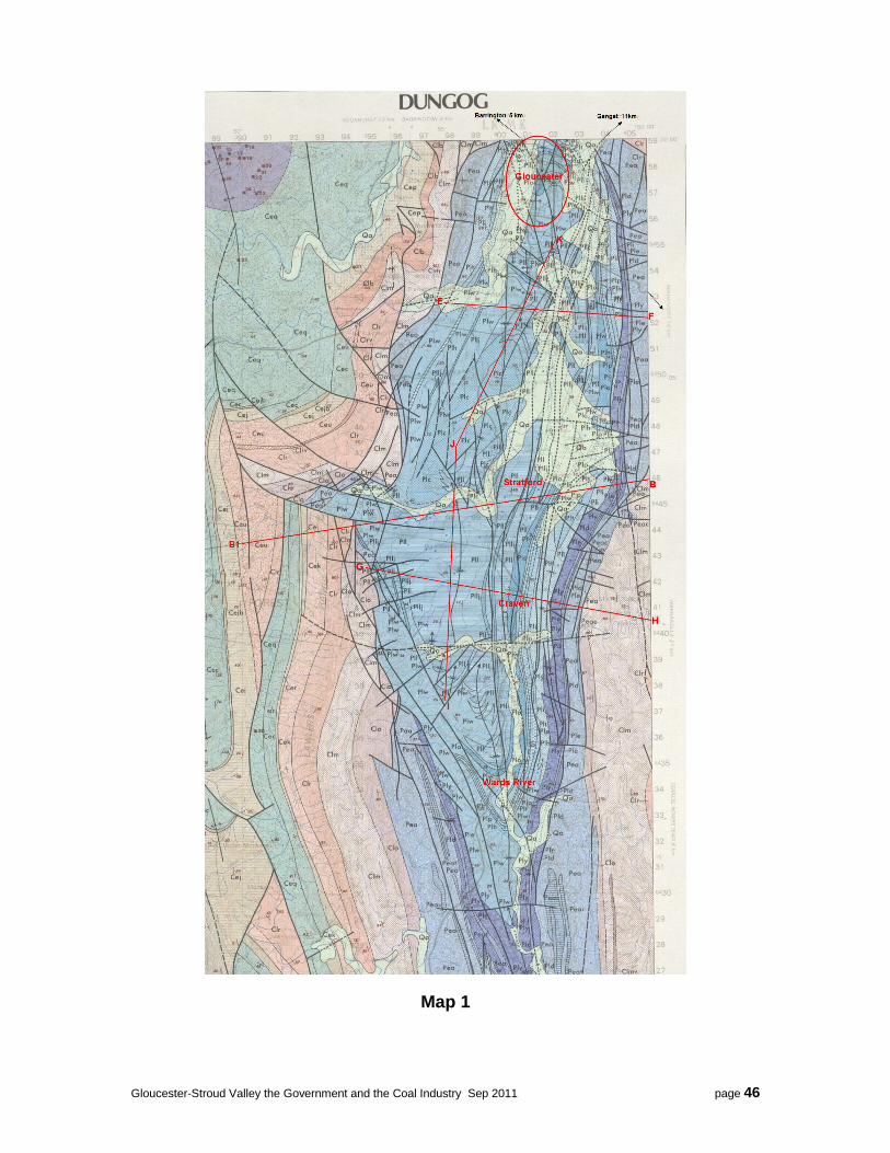
Gloucester-Stroud Valley the Government and the Coal Industry Sep 2011 page 46
Map 1

Gloucester-Stroud Valley the Government and the Coal Industry Sep 2011 page 47
Map 2
Structural Features of Geological Maps 1 and 2 The Stroud - Gloucester Syncline is a narrow feature which can be envisaged as a canoe-like structure having closures at Stroud and just north of Gloucester. The lighter blue colours on the map represent the Gloucester Coal Measures which contains the Avon, Bowens Road and Cloverdale and other seams that are currently being mined to the east of Stratford. The darker purple colours represents the Dewrang Group that contains the Weismantel and Clareval seams that are being mined at Duralie near Stroud Road, and also now being explored along the eastern boundary of the valley close to Gloucester town. GCL are drilling northwards to

Gloucester-Stroud Valley the Government and the Coal Industry Sep 2011 page 48
Fairbairns Road and Gloucester Resources Limited (GRL) are drilling north of Fairbairns Road to somewhere north of Jacks Road. Unlike other areas where the geology is essentially flat or horizontal, the sedimentary rocks, which contain the coal beds, have been folded and are very steeply dipping with numerous north-south and east-west trending faults. As can be seen maps indicate highly complex structures exist with many faults and directions. The faulting increases in intensity between Craven and Gloucester. The cross sections display the steeply dipping rock strata. Cross section B-B1 shows a large throw reverse fault to the east of Stratford which displaced the Dewrang Group 400metres vertically. The strata near the centre of the syncline axis has its sedimentary rocks dipping at angles of between 30 to 50 degrees and can be more than 60 degrees at the edges of the basin and in some cases nearly vertical. The geological map shows just how complex this syncline structure is and geologists have classified the various fault types into six categories:
1. Most of the major faults are along the axis (approximately north-south), along the Syncline and are related to the folding.
2. North-south low angle thrust faults dipping to the west 3. North westerly Strike Slip faults. 4. Reverse faults (trending along the axis) 5. East-west Normal Faults 6. Shearing and/or Normal Faults (trending in north easterly direction).
Associated with the folding, the sedimentary rocks will have undergone fracturing and jointing. It is these joints and fractures that allow rocks with low porosity to store underground water which is mentioned later. (For a more detailed structural explanation - see Reference Section for Extracts from the Explanatory Notes which accompany the Dungog Sheet by the Geological Survey of NSW).
Structural Features of the above Geological Cross Sections. The cross sections are not to scale but are included to demonstrate the combination of complex faulting and steeply dipping strata in the Stroud-Gloucester Syncline.

Gloucester-Stroud Valley the Government and the Coal Industry Sep 2011 page 49
Cross section B-B1 (see Map 1 for location) cuts across the widest part of the Syncline near Stratford. Towards the east there is a fault that shows the large throw reverse fault which displaced the top of the Dewrang group in the order of 400 metres. From B-B1 we can estimate the approximate depths to the coal measures towards the centre of the basin. The Weismantel is approximately 1.8km deep and the Avon Sub Group (containing the main seams being mined to the east of Stratford by GCL), and their depth varies from 800 to 900 metres. Cross Section F-E (see Map 1 for location) is east-west direction through the basin approximately 2kms south of Jacks Road, Gloucester.
Cross Section H-G (see Map 1 for location) approximately cuts east-west through Craven.
B-B1, F-E and H-G show the numerous north-south trending faults and very steeply dipping strata which concentrate mainly on the Eastern boundary of the valley. It is this section that contains most of the accessible coal and coal seam gas deposits. It appears from these sections that most of the coal is on the eastern side of the syncline. However, Gloucester Resources Limited (GRL) are currently exploring the western limbs of the Syncline on Woods Road and Upper Avon road near Craven.

Gloucester-Stroud Valley the Government and the Coal Industry Sep 2011 page 50
Cross Section K-J-I (see Map 1 for location) runs from Jacks Road, near Gloucester to about 3kms north of Wards River and generally follows the axis line of the Stroud-Gloucester Syncline. This section shows the east-west faulting which seems to be concentrated near Gloucester, around Stratford, and south of Craven. Water Sources for the Stroud – Gloucester Basin Water generally exists above ground as streams, creeks and rivers and underground as aquifers. The aquifers consist of clean water in alluvial sediments, and also in fractured and jointed rocks below the alluvial sediments, and as saline water in the coal seams. (See explanatory notes in the reference section). There is a relationship between the creeks and the alluvial aquifers where the creeks charge the alluvial ground water. During extended dry periods the alluvial ground water flows into drying creeks. The underground rock and coal aquifers are recharged by rain on the edges of the basin through faults and subcrops. Water also seeps down into the rock structure from the alluvial deposits. There is a complex relationship with the ground water systems due to the complex geological structure in the Syncline. Most knowledge of water storage and movement derives from the „flat geology‟ districts that have virtually no correlation with the Stroud-Gloucester Basin. (See Reference Section for Extracts from the Explanatory Notes which accompany the Dungog Sheet by the Geological Survey of NSW).
Risks Coal Seam Gas – AGL‟s Gloucester Project Gloucester recently had a forum on air, water, coal and health presented by the Clean Air Society of Australia and New Zealand. This included seven academic speakers on several topics but the common theme from all of them was that they didn‟t know anything about the Stroud-Gloucester valley. All their examples came from outside the area. Garry Willgoose, University of Newcastle, spoke on coal seam gas, water and fraccing and continually referenced his experience in „flat geology‟ Broke, NSW where AGL is establishing a coal gas extraction mine. Willgoose refrained from commenting on the Gloucester-Stroud Syncline claiming no knowledge of the area.

Gloucester-Stroud Valley the Government and the Coal Industry Sep 2011 page 51
AGL continue to say that this is a safe area to practice CSG extraction. It was said that AGL (or the then Molopo/Lucas) had several problems with exploration drilling. On encountering fractured rock, circulation was lost, producing costly exploration outcomes . Subsequently, they ceased exploration drilling and conducted a three dimensional seismic survey to locate areas where the drilling was less likely to encounter the Gloucester-Stroud Syncline‟s geological complexities. Basically, CSG extraction, involves two stages. First is drilling to the bottom of the coal bearing strata and fraccing the target seam. This involves pumping water, sand and some chemicals into the coal seam. Secondly to extract the gas, the water table has to be drawn down by pumping water out of the hole. This dewatering process reduces the pressure on the liquid gas methane associated in the coal and allows it to gasify and escape up the well. The CSG extraction can only work by reducing pressure on the deep coal seams and to do this they draw down the water table 300 to 600 metres or more. Garry Willgoose showed a diagram of a horizontal coal seam and explained how the fraccing only runs horizontally along the seam due to tectonic stresses applied to an area - relating back to tectonic plate movements. He didn‟t offer any advice about fraccing coal seams in areas with seams dipping 50 degrees in a heavily faulted, intensely complex geology. Risks associated in coal seam gas extraction process are:
Holding and disposal of large quantities of production water (unfit for consumption by humans and animals – see Corkery Report) in waste water dams and turkey nest dams. These are likely to allow spill events into the catchment during heavy rain events.
Possible escape of fraccing chemicals from the target coal seam escaping into the surrounding aquifers. Also there is no mention by AGL of what happens when fraccing is close to fault zones. It is likely that the fraccing energy and chemicals will spread out in all directions into the fault zone into other aquifers. (refer to Maps 1 and 2 and Cross Sections)
Possible migration of saline coal seam water being forced out into the clean water aquifer and consequent escape into alluvial aquifers and streams and rivers.
Large scale draw down of the water table during the gas extraction phase of the wells life time. AGL plans 110 wells spaced about 600 metres apart which could impact community and farming access to water. It poses a risk of upsetting the balance in the ground water systems for an unknown time into the future.
Migration of fraccing chemicals or saline water through poorly prepared and not properly sealed well holes allowing these liquids the opportunity - perhaps undetected - to mix with clean aquifers.
Mishaps occurring during the production phase due to faults in knowledge, equipment, process, supervision, short-cuts or movement in geological conditions. Examples of unexpected gas and water releases with emergency responses already exist.
The high potential that AGL will proceed with its preferred waste water disposal – spray on pastures for absorption and evaporation – which must create enduring and extending saline and chemical plumes.
Dust pollution from the large number of truck movements required to remove „production‟ water and deliver clean water, sand and chemicals over dirt access roads.
Coal Mining – Gloucester Coal Limited Geologists involved in exploration drilling for the Stratford Coal Mine, cite faulting as one of the major problems encountered. It caused difficulties in the correlation of seams during exploration drilling. Most of GCL‟s mine planning is designed around or up to fault planes. This demonstrates the complexity of mining in the area. When they complete a working pit, they then pump waste water
Gloucester-Stroud Valley the Government and the Coal Industry Sep 2011 page 52
from the washery into the excavated pit and these toxic wastes have direct access to joints, fault zones - with possible ingress to the ground water system. During exploration drilling, one of the geologist‟s tasks is to measure the water flows at the rig to give an estimation of the ground water at the site. To do this they use a „V‟ notched weir placed at the overflow from the drilling rig. At Gloucester it was commented that there was so much ground water produced that it was impossible to measure the flows and only rough guesses were attempted. These geologists commented at the time that this will be a difficult area for open cut mining. To overcome the water and to allow open cut mining the water table has to be lowered by pumping out the ground water to at least 75 metres to prevent the pit filling up. Toxic Elements associated with Coal Some of the potentially toxic elements that are found in coal include mercury, beryllium, asbestos, cadmium, arsenic, lead and fluorine. All these elements have undesirable physiological effects on plant and animal life. Pyrite is the common mineral found in coal. The Weismantel coal seam is a high sulphur coal,
predominantly pyrite, which makes it unsuitable for steaming coal and has to be brought by rail from
Duralie to the Stratford washery plant for processing and blending. This process concentrates Duralie’s
waste at Stratford.
The mineral pyrite, or iron pyrite, is an iron sulfide with the formula FeS2 and is the most common of the sulfide minerals. Pyrite is usually found associated with other sulfides in coal beds. Gold and arsenic also occur as a coupled substitution in the pyrite structure. Pyrite exposed to the atmosphere during mining and excavation reacts with oxygen and water to form sulfate, resulting in acid mine drainage held in the waste water holding dams. Risks associated with coal mining are:
Open cut coal excavation requires a draw down of the water table to about 80 meters to allow removal of the overburden and coal. This water contains contamination from mine blasting chemicals and residues, diesel from equipment, released heavy metals from the broken rock and drill rig chemical aids. The water is pumped to holding dams and stored for release into creeks, large scale irrigation on to land. More recently there is an investigation into the use of mist sprays to speed the evaporation process. All of these processes risk or deliberately countenance the release of contaminants into the ground water and streams. These processes are not monitored for environmental impacts.
Overtopping dams through heavy rainfall events allow contaminants to flow into the river system.
Concentrating toxic waste from the coal preparation plant and coal washery into open pits where it has access to the ground water system. This waste combines toxic waste from the high sulphide coals and chemicals from the washery process. Pyrite is a big contaminant in coal from Duralie (Weismantel Seam). The toxic elements, arsenic, lead, cadmium, mercury, beryllium, fluorine and asbestos are concentrated in the washing plants and pumped into old pits and managed with limestone to neutralize the pH of the water. The old pits have fault and shear zones in them which should be expected to allow migration of these concentrated elements into surrounding aquifers and hence into streams.
Coal washery plants also use chemicals in the process of coagulation/flocculation process involving some type polyacryamide based flocculant. Washery waste also ends up in the holding pits. These chemicals pose a multiple threats to plants and aquatic life and water users.

Gloucester-Stroud Valley the Government and the Coal Industry Sep 2011 page 53
Higher throughputs with increased tonnage have put pressure on waste water management and possibly require greater draw down of the water table.
Large scale irrigation on mine owned lands of waste water presents a very real risk of run-off and the spread of enduring plumes of affected soils extending beyond the life of the mine. Heavy rain periods move the waste products into creeks and ingress into the alluvial and lower aquifer systems. This carries the potential to sterilize the land‟s future use for agriculture.
Planned release of toxic waste water into our river system, even if managed should be expected to still cause problems down stream.
Proposed misting of waste water into the atmosphere to speed evaporation will disperse an unseen pollution over residents and food production lands, and settle into the water system and house water tanks.
Overburden piles are currently seeded and grassed. The overburden piles are mountains of crushed rock dug up from up to 80 meters depth and are free draining and offer no structural water table. There is a risk that in the future these overburden piles won‟t sustain the new plant life and become barren.
GCL is the largest owner of agriculture land. John Williams, the NSW Natural Resource Commissioner, at a forum in Sydney (17/05/2011), says the laws need to be changed to ensure mining exploration companies face the same controls as other land users. "What I'm arguing for is that the acts for mining exploration be consistent with our acts for native vegetation management and water management". Agricultural landholders have to meet strict legislation and authority rules including Native Vegetation Act, Catchment Management Authority and Private Native Forestry Act and others. Under the Mining Act of 1992, mining is pretty much exempt from these restrictions.
Mining and Its Potential Impacts Downstream to the Manning and Karuah Rivers Craven, located around the centre of the Gloucester-Stroud Syncline, marks the valley water-shed. Surface water flows north from Craven into the Avon, then Gloucester and finally out into the Manning Catchment area. Water flows to the south of Craven into the Mammy Johnston Creek and into the Karuah River Catchment areas. Polluting these river systems will have a large geographical reach affecting a large population of unwary people relying on clean water. There is a number of ways these rivers can be polluted:
Direct out flow of contaminated water from GCL and AGL holding dams into the rivers.
Toxic waste held in dams or completed open cut pits which allow chemicals to leach into the ground water system via faults, jointing and shear zones.
Fraccing chemicals that escape the coal seam being targeted. Consideration should be given to what happens when fraccing near to faults and steeply dipping coal seams.
Air pollution (PM10 and PM2.5) from open cut mining, blasting operations (explosive residues), diesel combustion wastes, conveyor transportation to washery and/or coal loader, these dusts can transfer onto ground surfaces and washed into streams and rivers.
Large scale irrigation to reduce holding dam levels.
A new technique being investigated where contaminated water is sprayed as a fine mist into the atmosphere with the objective of fast evaporation.
Cumulative Risks to the Whole System: Water is essential for our wellbeing and survival. Assessment of cumulative risks that could affect water security and environment must also consider all the aspects of increased activity requiring water in the valley. Both coal mining and CSG extraction put heavy demands on water
Gloucester-Stroud Valley the Government and the Coal Industry Sep 2011 page 54
systems principally by drawing down the existing water tables and drawing up contaminants as part of the dewatering process. The new exploration areas involve the eastern boundaries which are one of the main recharge areas for coal seam and jointed rock aquifers. However the reduction of water will impact local dairy farmers and other agricultural activities which should be expected to take more from the river systems. Extended dry periods will exacerbate this supply and the whole picture sees the Gloucester water system out of balance. Before mining started this balance in underground water and the streams and rivers maintained equilibrium. However mining and CSG extraction could impact on the valley to render it a dust bowl or at least turn it into a salt basin thereby reducing food production. A conscientious belief in harm minimisation would invoke the precautionary principle. Recommendations
Start some scientific physical, chemical and biological testing of boreholes and the streams around Gloucester to develop bench marks and then be in a position to ring the alarm bells if any extractive industry has any affect on the ground water and rivers water quality. Results could be used to evaluate the explorer‟s Environmental Impact Studies (EIS), and to be in a position to monitor production wastes and their impact on the environment.
A scientific study of the prevailing wind strengths and directions should be completed for the valley which would allow for an intensive particulate matter including PM10 and PM2.5
Water Security Monitoring Streams and Rivers for Clean Water. (Where is the Catchment Management Authority (CMA) and where is Mid Coast Water?)
Reject coal seam gas extraction in the Gloucester valley
Mining be subject to the same environmental laws as every other Australian citizen.
Mining to manage their waste responsibly and demonstrate this by transparent monitoring and assessment by independent persons.
Exploration Licences should be revisited. They have a large impact on the landholders and in the case of GCL, who have been able to hold there licences for over 40 years with no consideration for the landholders, something should be done about paying some type of rental for the inconvenience. A Fairbairns landholder spoke to the new GCL CEO‟s assistant about their plans for drilling on his property. He asked if the exploration showed that if there wasn‟t an economic resource would they relinquish the exploration licence and let him get on with his life. GCL representative said no, the coal could be worth mining in 10 to 20 years, to which even he considered was unfair. Perhaps a rental paid to the landholders would put pressure for the mining companies to shelve off unwanted land more effectively and quickly.

Gloucester-Stroud Valley the Government and the Coal Industry Sep 2011 page 55
GEOLOGY: Part 2 Reference material The Explanatory Notes to accompany the Dungog 1:100,000 Geological Sheet, Geological Survey of NSW. The Stroud-Gloucester Syncline is a fault-bounded trough, being about 55km long and 24km in width at its widest part. In overall outline the syncline trends northwards between Stroud and Stratford and then swings a bit more to the east from Stratford to Gloucester. The axial plane is inclined slightly towards the east, and the syncline is a tight, canoe-like structure, having closures at either end. The notes continue to state that some blocks to the north east are overturned and generally the limbs dip at more than 60‟ and often nearly vertical. Dips of the structure closer to the Syncline axis are of the order of 30 to 50‟. The Syncline structure is complex and can be reduced to six components:
1. Synclinal folding with the axis approximately north-south. Most of the major faulting are axial faults related to the folding. The most important of these is the „Williams River Fault‟ which forms the western margin of the Myall Block, (containing the Stroud-Gloucester Syncline).
2. Low angle, west-dipping, broadly north-south thrust faults 3. North westerly Strike Slip faults. 4. Reverse faults (trending along the axis) 5. East-west Normal Faults 6. Shears or Normal Faults striking 040‟ to 060‟ (north easterly direction)
The Dungog 1:100,000 Geological Sheet shows the basin structure with its major faulting. The cross sections show for example of a large throw reverse fault just east of Stratford which displaces the top of the Dewrang Group 400m vertically. The syncline sedimentary infill has been controlled by near vertical north-northwesterly trending strike slip faults which locally have substantial vertical components. “Note the Dewrang Group of Permian sediments contain the Weismantel and Clareval coal members which Gloucester Coal Ltd mine to the south at Duralie Mine. The Gloucester Coal Measures contain coal seams like Avon and Bowens Road which are mined at Straford by GCL. However the Weismantel and Clareval also run along the western boundary of the syncline and are currently being explored by both GCL and GRL. These seams subcrop up the hills which form the eastern edge of the Gloucester valley and form part of the ground water recharge areas. Open cut mining of these areas will be in full view from Gloucester township and The Bucketts Way”. (Authors note) So the eastern margin of the Permian section of the syncline is controlled largely by meridional reverse faults, many with substantial throws. The south-west has also been controlled by meridional reverse faults and the interior sedimentary infill has been controlled by near vertical north-northwesterly trending sinistral shears (strike slip faults). The extreme northern edge of the syncline is also controlled by sinistral shears, (the best exposed example is on the barrinton road. These were active during the depositional hiatus between the Alum Mountain Volcanics, (the volcanic rocks that form the hills to the east and the Bucketts to the west), and the Dewrang Group. The north western edge and the flexure in the syncline east of Stratford are controlled by north-northeasterly to northeasterly trending shears or normal faults. Within the remainder of the syncline, sedimentation has been controlled by meridional reverse faults, east-west normal faults, and by northeast striking shears and normal faults. Ground water within the Stroud-Gloucester Syncline occurs in aquifer systems within either fractured (and including jointed / faulted) rock or unconsolidated sediments.

Gloucester-Stroud Valley the Government and the Coal Industry Sep 2011 page 56
Fluviatile Environment. (Shallow alluvial aquifer) There are significant groundwater resources associated with the Gloucester and Avon Rivers. The thickness of these sediments vary and rarely greater than 10 metres. Groundwater levels in the alluvium are generally shallower than 7 metres and are mostly slightly above or at river bed level. Stream flow is the main source of recharge to the alluvial aquifers. The direction of groundwater flow is dominantly down-valley with a component to or from the stream, depending on relative levels of the stream and groundwater table. Stream flow and rainfall readily recharge these sediments and the salinity of the groundwater is generally much lower than that occurring in the underlying fractured rock. Deterioration in water quality is often noticeable at times of low stream flows. Fractured Rock. 1. Shallow weathered bedrock aquifer with associated colluvial deposits. These rocks have been subjected to considerable folding and faulting. A network of joints joints and fractures enables them to store and transmit water. Groundwater generally enters fractures near the surface in topographically high areas, and drains through the open fractures and joints until it discharges into the surface drainage system. Standing water levels in boreholes in low lying sites often have water levels only a few metres below ground surface. 2. Permian Coal Measures aquifer of which the coal seams are the prime water bearing strata. Extract from „GLOUCESTER RESOURCES LIMITED - 40 - REVIEW OF ENVIRONMENTAL FACTORS. R. W. CORKERY & CO. PTY. LIMITED‟ (Referring to a report from - Gloucester Coal Exploration Program Report No. 806/05 – July 2010) Coal Seam Aquifers Studies undertaken for the Stratford Coal Mine EIS indicate that the coal seams are the main continuous aquifers in the basin. The Permian strata can therefore be categorised into two hydrogeological units. 1. Hydrogeologically “tight” and hence very low yielding to essentially dry sandstone and lesser siltstone that comprise the majority of the Permian interburden / overburden. 2. Low to moderately permeable coal seams which are the prime water-bearing strata within the Permian sequence. The coal seams are recharged by direct rainfall in outcrop areas or, as discussed, via leakage from the regolith or overlying colluvial deposits. The pristine water table/piezometric surface is a subdued reflection of the topography and groundwater levels are likely to vary from 15m to 20m below surface in higher elevated areas, to 2m to 6m below the floodplain level. Groundwater flow is to the west-northwest with potential for discharge to the basal alluvial aquifer along the creek/river system, via fractured overburden. The coal seams are extensively faulted with the faulting reported to compartmentalize groundwater flow. The hydraulic parameters of the coal seams can vary over a number of orders of magnitude depending on the depth of burial of the seam and degree of jointing and cleat density. Rising and falling head permeability tests indicate that the hydraulic conductivity of the coal seam aquifer ranges between 1.2 x 10⁻⁷m/sec to 3.3 x 10⁻⁵m/sec. Groundwater in the coal seams is generally saline, highly mineralized and hard with a slightly alkaline to acidic pH unsuitable for domestic consumption and in some cases unsuitable for stock / irrigation. The Electrical Conductivity (EC) of the coal seam groundwater increases with depth, that is as it moves away from the recharge source, with increases from 1395μS/cm at near surface, to 3070μS/cm at 97m. Similarly total hardness increases from 300mg/L to 730mg/L. Groundwater monitoring of bores around the Stratford Coal Mine pits indicates that the groundwater is slightly acidic in the general range pH 6.2 to 7.0 and that the EC is in the general range 2000-9000μS/cm (AEMR 2009).

Gloucester-Stroud Valley the Government and the Coal Industry Sep 2011 page 57
Inflow to the Stratford Open-cut Mine from the coal seams was estimated at between 25-40L/s in the initial years of development reducing over time to about 4L/s (126ML/year). The Stratford Mine AEMR (2009) reports that for the year 2008 groundwater inflow to the Roseville Extended and West Pits was 142ML and to the Bowens Road North Pit 193ML.