2015 united states geography olympiad elementary...
TRANSCRIPT

United States Geography Olympiad | Elementary and Middle School National Championship | Geography of the US Test | Pg. 1
2015 UNITED STATES GEOGRAPHY OLYMPIAD
ELEMENTARY AND MIDDLE SCHOOL NATIONAL CHAMPIONSHIP
TEST A: GEOGRAPHY OF THE UNITED STATES
You will be awarded two points for a correct answer. You will not lose any points
for a blank response. You will lose one point for any incorrect answers.
Please answer the 50 multiple-choice questions on the answer sheet. Then answer
the 10 tiebreaker questions on the last page, separate it, and hand it to the
proctor. Tiebreaker questions will only be used to determine medal placement.
1) Founded in 1610, what city in New Mexico is the oldest state capital in the United
States?
a) Albuquerque b) Santa Fe c) El Paso d) Las Cruces
2) Shown here is the New River
Gorge Bridge, the third-highest
bridge of the United States and
a significant landmark in which
state?
a) South Carolina
b) New Hampshire
c) West Virginia
d) Maryland
3) Which of the following states is divided into parishes instead of counties?
a) Louisiana b) North Carolina c) Rhode Island d) Alaska
4) While the Amish are most associated
with Lancaster County, Pennsylvania,
this image was taken southwest of
Canton in Holmes County in what state,
home to the most Amish people?
a) California
b) Ohio
c) Illinois
d) Georgia

United States Geography Olympiad | Elementary and Middle School National Championship | Geography of the US Test | Pg. 2
5) Shown above is Mount Katahdin. It marks one end of what trail?
a) Oregon Trail b) Chisolm Trail c) Yukon Trail d) Appalachian Trail
6) The headquarters of
Comcast and a historic
city hall topped with a
statue of William Penn
help populate the skyline
of what city, seen here?
a) Chicago
b) New York
c) Phoenix
d) Philadelphia
7) Part of the Everglades is actually a slow-moving river draining what body of water?
a) Lake Okeechobee b) Mississippi River c) Okefenokee Swamp d) Biscayne Bay
8) The Lower Peninsula of Michigan borders Ohio and which other state?
a) Illinois b) Indiana c) Wisconsin d) Florida

United States Geography Olympiad | Elementary and Middle School National Championship | Geography of the US Test | Pg. 3
9) Red, open-air bus-like vehicles called
jammers are a popular way to tour which
national park, along the U.S.-Canada border?
a) Glacier
b) Yellowstone
c) Rocky Mountain
d) Mesa Verde
10) The Willamette River valley is located in which state?
a) Washington b) Oregon c) Idaho d) Montana
11) Guam and Saipan are part of what archipelago?
a) Samoa b) Aleutians c) Fiji d) Mariana Islands
12) The Chesapeake Bay is NOT a good place to find which of the following marine items?
a) Blue crab b) Oysters c) Manatees d) Rockfish
13) Shown here are
sunflowers, the state flower of
what state?
a) Maine
b) California
c) Wisconsin
d) Kansas
14) Urbana/Champaign and Bloomington/Normal are sets of adjacent cities in what state?
a) Indiana b) Illinois c) Wisconsin d) Rhode Island
15) Which of the following Arizona cities is the closest to Mexico?
a) Tucson b) Phoenix c) Flagstaff d) Tempe

United States Geography Olympiad | Elementary and Middle School National Championship | Geography of the US Test | Pg. 4
16) St. Anthony Falls along the
Mississippi River was the focal
point of industrialization in what is
now what city?
a) New Orleans
b) Louisville
c) Memphis
d) Minneapolis
17) Amarillo is the largest city in what region?
a) Texas Panhandle
b) Oklahoma Panhandle
c) Baja California
d) Big Bend National Park
18) Telegraph, Nob, and Russian are all what?
a) Freeways in Los Angeles
b) Hills in San Francisco
c) Counties in California
d) Trails used by Gold Rushers in 1849
19) Shown here is President Jimmy Carter
attempting to fend off a giant swimming rabbit in
an incident that took place in April 1979 near his
home about 80 miles southwest of Macon in
which state?
a) Alaska
b) Minnesota
c) Maryland
d) Georgia
20) Which state does not border Iowa?
a) Kansas b) South Dakota c) Wisconsin d) Nebraska

United States Geography Olympiad | Elementary and Middle School National Championship | Geography of the US Test | Pg. 5
21) Despite not being
anywhere near an ocean,
the Sandhills region covers
about one quarter of what
state?
a) Nebraska
b) New Mexico
c) West Virginia
d) Arkansas
22) The Trans-Alaska Oil Pipeline ends in what city, located on Prince William Sound?
a) Anchorage b) Valdez c) Fairbanks d) Juneau
23) Shown here is what lake, the
second deepest in the United
State, shared by two states, and
drained by the Truckee River?
a) Pyramid Lake
b) Lake of the Woods
c) Lake Tahoe
d) Crater Lake
24) Which of the following mountain ranges cannot be found in Idaho?
a) Sawtooth b) Lost River c) Bitterroot d) Wasatch
25) An intrusion of igneous rock is believed to have created what Wyoming landmark?
a) Old Faithful b) Stone Mountain c) Chimney Rock d) Devils Tower
26) The “Research Triangle” is a name given to a trio of cities containing its state’s two
largest public university and a prestigious private university in which state?
a) California b) North Carolina c) Tennessee d) Delaware
27) Arlington County and the City of Alexandria are directly across a river from what city?
a) Dallas b) Atlanta c) Washington, DC d) Philadelphia

United States Geography Olympiad | Elementary and Middle School National Championship | Geography of the US Test | Pg. 6
28) What, approximately, is the population of the United States?
a) 210 million b) 290 million c) 320 million d) 380 million
29) The outline in this map outlines
what hydrographic region which
dominates Nevada and western Utah,
where no water flows eventually to
neither the Pacific nor the Gulf of
Mexico?
a) Great Basin
b) Deseret
c) The Snakehole
d) The Great Western Sink
30) The Breakers, seen here, is a seaside
mansion once belonging to the Vanderbilt
family in Newport in what state?
a) Oregon
b) New Hampshire
c) North Carolina
d) Rhode Island
31) Which of the following state capitals is
also the most populous city in its state?
a) Little Rock, AR b) Jefferson City, MO c) Springfield, IL d) Madison, WI
32) The state flag of South Carolina features what type of tree?
a) Palmetto b) Pine c) Mangrove d) Fir
33) The Green Mountains are in what state?
a) New York b) Vermont c) Maine d) California

United States Geography Olympiad | Elementary and Middle School National Championship | Geography of the US Test | Pg. 7
34) Which of the following bridges does not connect two of New York City’s boroughs?
a) George Washington Bridge
b) Brooklyn Bridge
c) Verrazano-Narrows Bridge
d) Queensboro Bridge
35) The Mississippi-Louisiana border is
formed by the Mississippi River, a
straight east-west line, and what other
river, circled on this map?
a) Pascagoula
b) Alabama
c) Pearl
d) Jackson
36) Boston and Cambridge lie on
which river?
a) Charles
b) James
c) Crosby
d) Green
37) Shown here is a barrier island
impacted by Hurricane Sandy in
2012. This storm most directly
impacted which vacation
destination?
a) Miami Beach
b) The Jersey Shore
c) New Orleans
d) Cape Cod
38) What state not only is split between multiple time zones, but also has had a
contentious debate over whether or not to observe Daylight Savings Time?
a) Arizona b) Maine c) Indiana d) Ohio
39) The city of Mobile is one of the few maritime cities in what state?
a) Mississippi b) New Hampshire c) Delaware d) Alabama

United States Geography Olympiad | Elementary and Middle School National Championship | Geography of the US Test | Pg. 8
40) The Mile High City is a nickname of what major city?
a) Salt Lake City b) Denver c) Albuquerque d) Phoenix
41) Today (May 22, 2015) is the four-year
anniversary of a natural disaster of what
type devastating Joplin, Missouri?
(Aftermath shown here)
a) Ice storm
b) Hail storm
c) Tornado
d) Wildfire
42) The controversial practice of fracking has helped North Dakota attain what distinction?
a) Most oil production of any state
b) Lowest unemployment rate in the United States
c) Most polluted state in the country
d) Most houses with broadband internet
43) Due to the large military presence during
World War II, dishes like the one pictured
here using the processed meat product
known as “Spam” became especially popular
in which state, the largest consumer of
Spam?
a) Florida
b) Alaska
c) Hawaii
d) California
44) Mount Olympus names the home of the Greek gods as well as a mountain at the
center of the Olympic Peninsula in what state?
a) Washington b) Oregon c) Alaska d) New York

United States Geography Olympiad | Elementary and Middle School National Championship | Geography of the US Test | Pg. 9
45) If you’re taking this test at the 2015 Elementary and Middle School National
Championships, which of the dots on the below map best correspond to your current
location? Use the letters on the map
46) Despite its name, the Canadian River is an important river in what state, where it flows
through the state capital?
a) Arkansas b) Nebraska c) North Dakota d) Oklahoma
47) The arrow on this map points to
what colorfully-named bay?
a) Black Bay
b) Green Bay
c) Red Bay
d) Grey Bay
United States Geography Olympiad | Elementary and Middle School National Championship | Geography of the US Test | Pg. 10
48) Which of the following Interstate highways passes through the fewest states?
a) Interstate 5
b) Interstate 70
c) Interstate 80
d) Interstate 95
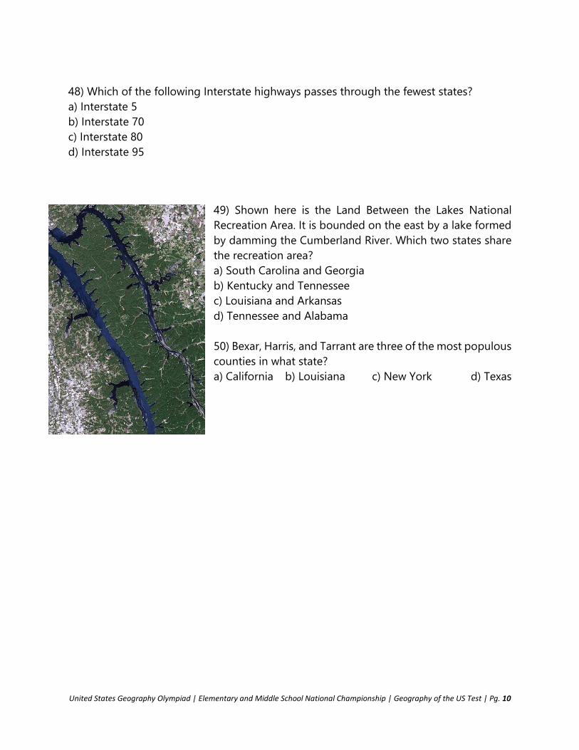
49) Shown here is the Land Between the Lakes National
Recreation Area. It is bounded on the east by a lake formed
by damming the Cumberland River. Which two states share
the recreation area?
a) South Carolina and Georgia
b) Kentucky and Tennessee
c) Louisiana and Arkansas
d) Tennessee and Alabama
50) Bexar, Harris, and Tarrant are three of the most populous
counties in what state?
a) California b) Louisiana c) New York d) Texas

United States Geography Olympiad | Elementary and Middle School National Championship | Geography of the US Test | Pg. 11
STOP.
The main part of the test is complete. These are tiebreaker questions that
will ONLY BE USED TO BREAK TIES TO DECIDE THE TOP THREE POSITIONS IN
EACH DIVISION. They will be graded in order.
SEPARATE THIS PAGE AND HAND IT TO THE TEST PROCTOR, EVEN IF YOU
LEAVE IT BLANK
Name: ______________________________________________________________________________
School: _____________________________________________________________________________
Fill in the blank.
1) Indianapolis is located in ______________________________ County.
2) Eppley Airfield is the primary airport of _____________________________. (Name the city.)
3) The Sacramento and San Joaquin Rivers flow into _________________________________Bay
before entering San Francisco Bay.
4) Tahlequah is the capital city of the ________________________ Nation.
5) ____________________________________________ is the second-largest city in New England.
6) The _______________________________________ separates Ocracoke Island and the southern
Outer Banks from the rest of North Carolina.
7) The Twelve Mile Circle forms the northern border of _________________________.
8) Antelope Island is the largest island in ____________________________. (Name the lake.)
9) Elko and Winnemucca are cities in _____________________________. (Name the state.)
10) The ______________ River gives its name to a type of river that runs parallel to the river
it flows to for an extended period and joins the Mississippi River at Vicksburg.