2015-2017 grant solicitation - · pdf file2015-2017 grant solicitation ... plans for rcc dam...
TRANSCRIPT

2015-2017 Grant Solicitation
WATER CONSERVATION, REUSE AND STORAGE FEASIBILITY STUDY GRANT PROGRAM
GRANT APPLICATION
APPLICATION INSTRUCTIONS
1. Complete Sections I through VII in the spaces provided. 2. An application must be submitted on a form provided by the Department. An explanation must
accompany the application if any of the information required cannot be provided [OAR 690-600-0020(6)].
3. If in hard copy - use 8 ½” x 11” single sided, unstapled pages. Provide any attachments to application also on 8 ½” x 11” single-sided, unstapled pages. Avoid color and detail that will not photocopy clearly.
4. Please Contact the Department’s Grant Specialist Jon Unger at 503.986.0869 or [email protected] if you have any questions.
Application Deadline: February 1, 2016 5:00 PM,
(Application must be received by this date and time)
Mail application to:
OREGON WATER RESOURCES DEPARTMENT Attention: Grant Specialist
725 Summer Street NE, Suite A Salem, OR 97301

KEY GRANT INFORMATION Introduction. The Water Conservation, Reuse and Storage Grant Program, established by Senate Bill 1069 (2008), is designed to fund the qualifying costs of feasibility studies that evaluate the feasibility of developing water conservation, reuse or storage projects. Oregon is facing increasing water demand and increasingly scarce water supplies. To adequately meet Oregon’s diverse water demands now and into the future, Oregonians must use their water wisely and efficiently. That means looking more closely at innovative water conservation and reuse programs and environmentally sound storage projects that capture available water so it can be put to good use when needed. What is a feasibility study? A feasibility study is an assessment of a proposed plan or method. Typically there should be a previously identified water project that appears to have merit but is lacking important details necessary to determine whether or not to proceed. The feasibility study focuses on helping answer the essential question of “should we proceed with the proposed project idea?” All activities of the study are directed toward helping answer this question. Ideally the project identified will have community support and will have been identified through a collaborative process. Match Funding. To be eligible for funding applicants must clearly demonstrate funding from a source other than the Program of not less than a dollar-for-dollar match from cash or in-kind services. For example, if $25,000 is requested in Program Funds, then there must be a match of at least $25,000 from another source. The matching funds must be secured or in the process of being secured. The maximum grant award is $500,000. Eligibility Requirements for Storage Studies. To be eligible for funding for a project feasibility study associated with a proposed storage project that would: Impound surface water on a perennial stream; Divert water from a stream that supports sensitive, threatened or endangered fish; or Divert more than 500 acre-feet of surface water annually, the proposed project feasibility study must contain the following elements:
• Analyses of by-pass, optimum peak, flushing and other ecological flows of the affected
stream and the impact of the storage project on those flows;
• Comparative analyses of alternative means of supplying water, including but not limited to the costs and benefits of water conservation and efficiency alternatives and the extent to which long-term water supply needs may be met using those alternatives;
• Analyses of environmental harm or impacts from the proposed storage project;
• Evaluation of the need for and feasibility of using stored water to augment in-stream flows to conserve, maintain and enhance aquatic life, fish life and any other ecological values; and
• For a proposed storage project that is for municipal use, analysis of local and regional water demand and the proposed storage project’s relationship to existing and planned water supply projects.
See Application Criteria and Evaluation Guidance for assistance in filling out this application.


Grant Program Funding Application Form – August 2015 Page 2

Grant Program Funding Application Form – August 2015 Page 3
IV. Grant Specifics Section A. Common Criteria Instructions: Please answer all questions contained in this section. It is anticipated that completed applications will result in additional pages.
1. Describe your goal and how this study helps to achieve the goal.
The goal of this project is to continue investigating feasibility of the City of Newport's preferred option of a Roller Compacted Concrete (RCC) dam, ensuring the Big Creek Reservoirs are seimically sound, securing access to safe drinking water, and protecting Newport's economy and quality of life. The proposed study helps achieve this goal by enabling the City to conduct pre-design work, conduct surveys of the project site, evaluate geotechnical conditions, assess hydrology feasibility, and prepare budget scenarios. Environmental permitting assessment will be conducted in tandem with this project, but will not be funded by this grant's budget. The information obtained during this study will inform a pending Newport City Council decision to move forward with the RCC dam project.
2. Describe the water supply need(s) that the proposed project addresses. Identify any critical local, regional, or
statewide water supply needs that implementation of the project associated with the feasibility study will address. Responses should rely upon solid water availability and needs data/analysis. For examples of water supply needs see “Criteria and Evaluation Guidance Document.”
Newport's proposed project will: 1) Secure the City's sole water supply, 2) Expand the storage capacity of the Big Creek Reservoir, and 3) Improve the region's resiliency to natural disasters. The project addresses the only drinking water source available for the City of Newport's year-round population of more than 10,000 residents, a tourist population of roughly 2.5M annually, the fishing industry, brewing industry, and the aquarium -- all of which are crucial to the region's economy. Prior examinations have concluded that both Big Creek Reservoir dams are highly susceptible to structural damage or complete failure during a seismic event. Subsequently, replacement of these dams are among the top three priority projects of the Oregon Dam Safety Engineer. Continuing feasibility research for the preferred replacement option will secure the City's successful approach to maintaining access to safe and affordable drinking water and ensure the region's safety during a seismic event or other natural disaster. Newport does not have sufficient redundant water storage facilities to support water demand should the Big Creek Dams fail. The current condition of the dams leaves the City of Newport's citizens and businesses very vulnerable to potential disruptions in water supply and a variety of natural disasters that occur regularly and/or are anticipated to occur including earthquakes, tsunamis, severe storm events, flash floods and landslides. The need for additional water supplies in the Mid-Coast Basin is a very real and urgent matter. A 2008 study titled, Lincoln County Water Needs Analysis, completed by WHPacific and GSI, projected that Lincoln County, as a whole, could experience a water deficit of 10.4 MGD by 2020 if additional water supplies are not secured. A list of water planning documents relevant to the Big Creek Dams Remediation project are included in Attachment A. Some districts in the Basin are already unable to meet current demands, let alone future demands. In fact, Otter Rock Water District recently approached the City in an attempt to purchase raw water to transport by truck back to their district to meet their district's current needs. The City of Yachats had severe water restrictions in 2015 due to water shortages. Finally, Georgia Pacific was recently in danger of shutting down operations at its Toledo plant (7 miles east of Newport, employing nearly 400 workers) because it could not draw enough water from the Siletz River to meet current demand. Another challenge to meeting water supply needs within the Basin is a mismatch in timing between water supply and demand. Demand for water from the City of Newport spikes in the summer when 250 million tourists visit the area. Newport must increase storage capacity to capture additional water during wet seasons in order to sustain water supplies during a low stream flow/high consumer demand summer sesason. Further, increased

Grant Program Funding Application Form – August 2015 Page 4
storage capacity will protect instream flow for sensitive fish populations, native subsistence fishing and recreational fishing. Building a new RCC dam provides opportunity to expand storage capacity to help mitigate the impact of high demand during the dry season.
3. Explain how the proposed project will meet the water supply need(s), and indicate what percentage of that need
will be met. (For example: If your water supply need is 20,000 acre-feet of additional water and the project will supply 10,000 additional acre-feet, 50 percent of your need will be met).
The remediation project addresses the only source of drinking water available for the City of Newport (more than 10,000 people, plus 250M visitors annually), and the largest source of drinking water in the Mid-Coast region (population greater than 40,000). The reservoir design considers raw water needs through the year 2030 as determined by the City of Newport's Water System Master Plan adopted in 2008 and revised in 2010. The project will build additional water supply capacity that can serve to support population growth, growth of economic activity and secondary supply resources for nearby water districts in the event of drought similar to that experienced in the summer of 2015.
4. Describe the technical aspects of the feasibility study and why your approach is appropriate for accomplishing the specific study goals and objectives.
Working with HDR, a global engineering firm, the City of Newport has completed initial steps to determine preferred alternatives for the replacement of Big Creek Dams #1 and #2. HDR & Newport have determined the most feasible option is a new Roller Compacted Conrete (RCC) dam downstream from Big Creek Dam #2 (See Attachments B, C, and D). This proposal seeks to continue feasibility studies and other key research to mature plans for RCC dam replacement and prepare the project for the design and environmental review phases.
Funding from this source will support the following project tasks:
Task I: Project Management - Project management will be provided during the next phase of work to guide evaluation activities; monitor and update the project scope of work, budget, and schedule; and, provide appropriate communication with the City. This includes invoicing as well as coordination with the City, the state dam engineer, and the HDR team for completion of evaluations and production of the deliverables. The purpose of this task is to plan and execute pre-design efforts of the HDR team and all subconsultants in accordance with the schedule and budget. Work activities described below will be provided to cover the project management activities.
Task II: Survey of New Dam Site and Surrounding Terrain - There is no existing survey of the area around the proposed site of the RCC dam. A survey will be completed during the first quarter of 2016. The survey will be performed in order to provide suitable site controls and topography for the dam site and related facilities in the surrounding areas such as new access roads, the raw water pipeline, and a fish passage facility. The survey will provide the information needed to estimate excavation volumes, topography, slopes of the future road and pipeline, and it provides the basis for establishing quantities for the new construction. The survey is needed for the design and cost estimates.
Task III: Site Characterization & Explorations - Geologic and geotechnical site characterization work has not previously been performed at the proposed dam site. Site characterization around the new dam location will help inform the feasibility evaluation, design development, and cost estimating. For instance, site characterization work will help estimate the depth to suitable bedrock underneath the dam footprint, and will provide other geologic and geotechnical information needed for planning level designs. HDR will conduct additional site characterization along the proposed road and pipeline route, downstream from the proposed dam, and the relocated road alignment and bridge crossings upstream from the proposed new dam location.
Site characterization work for the new dam will be performed in phases with each phase providing increasingly detailed information needed to address key issues and decision requirements. Early phases will support design configuration and risk management issues. The work will confirm feasibility and lead to a preliminary level design suitable for input to regulatory permits and preliminary design approvals along with establishing funding requirements. Additional explorations may be appropriate during final design to address regulatory requirements and key subsurface risk issues that are identified during the pre-design planning phase.

Grant Program Funding Application Form – August 2015 Page 5
During this phase, HDR will conduct additional drilling and soil samples testing of the site of the proposed dam, which will inform future site characterization and geotechnical work that will be needed during the design pahse. Data collected during this phase will be used to prepare the Design Criteria Technical Memo, which will provide recommendations for additional work needed to complete the design
Task IV: Design Criteria Memorandum - Prior to initiation of further engineering evaluations, HDR will prepare a design criteria memorandum summarizing the basis for the design of the dam, spillway, outlet, pipeline, roads, and fish passage structures/system.
Included as part of this memorandum will be an update of the desired reservoir storage volume. As previously noted, three components of the storage volume will be evaluated: 1) replacement of existing storage in Big Creek Dams #1 and #2, 2) supplemental storage due to sediment accumulation in the existing reservoirs, and 3) increased storage for future water supply demands.
A key consideration in the design criteria will be the seismic loading that will be used to develop the cross-sectional properties of the dam. Based on previous experience, we anticipate that an earthquake with an estimated recurrence interval of about 1,000 to 5,000 years will be appropriate for design. The methodology used to establish this criteria will be described, including the basis for estimating the tensile strength of the RCC materials and the required seismic performance of the dam for more extreme loading conditions. This includes allowable deformations and post-earthquake stability of the dam for events up to and including a maximum credible earthquake with an estimated recurrence of about one in 10,000 years.
The Design Criteria Technical Memorandum will identify the geologic and geotechnical parameters required to complete this phase and to finalize the geotechnical exploration and the laboratory testing plan. The explorations plan will identify the types and locations of both geophysical surveys and subsurface borings. The laboratory testing plan will identify the number and types of laboratory tests needed to establish the parameters identified in the gap analysis
Task V: Engineering Evaluations of the New, Proposed RCC Dam - A feasibility level evaluation of an alternative RCC dam configuration was completed as part of the previous alternatives evaluation for the project. During this phase, additional geotechnical and structural evaluations will be performed. This includes development of an updated model and corresponding evaluation of static, seismic, and flood loading conditions to refine and further optimize the dam configuration.
HDR will be using the software SAP2000 from Computers and Structures, Inc., and EAGD-SLIDE, a public domain program for these evaluations. SAP2000 is a general purpose, finite element method (FEM) modeling software used for both response spectra analysis and time-history analysis of structural systems. EAGD-SLIDE, Earthquake Analysis of Concrete Gravity Dams including Base Sliding, is a finite element computer program that is used to analyze the potential sliding along the base-concrete interface, allowing the computation of the factor of safety against sliding. EAGD-SLIDE is also used to evaluate the tensile forces in the RCC dam.
Task VI: Hydrology and Spillway, Outlet Works and Fish Passage Analysis - The objective of this task is to refine the configuration of the spillway, outlet works of the new dam, and to develop initial concepts for fish passage around the new dam to use in discussions/negotiations with state regulators of the project.
This task will include appropriate updates of the estimate of the Probable Maximum Flood (PMF) inflow hydrograph, reservoir routing, and hydraulic analyses of the spillway structure to identify a cost effective combination of spillway width to dam crest freeboard requirements. The outlet works, including the intake structure, will be designed to meet dam safety, as well as operational requirements, for both quantity and quality of water released from the reservoir. Fish passage analyses will be based on a possible fish passage facility incorporated into a natural drainage channel in the downstream left abutment area of the new dam.
Task VII: Access Road Feasibility - The existing access road from the lower dam (Big Creek #1) to the upper dam (Big Creek #2) serves as the only access to two private properties located on the north side of the upper reservoir, and to forest/logging land. The access road will have to be re-routed around the new dam structure. The development of the proposed road alignment will be divided into two parts: 1) the road to the top of the new RCC dam and 2) the road past the new RCC dam which provided access to the properties along the raised

Grant Program Funding Application Form – August 2015 Page 6
upper reservoir pool. This will be done in case funding is not available at the time to complete this task and the two portions can financially be separated.
Task VIII: Raw Water Pipeline Feasibility - The existing raw water pipeline is a siphon from the lower reservoir across the lower dam to the intake pump station located at the toe of the lower dam (Big Creek #1). The study is considering the feasibility of removing the lower dam structure and reestablishing Big Creek to its pre-development channel. As a result, a new raw water intake pipeline will need to be constructed from the outlet works of the new RCC dam to the existing intake pump station.
Task IX: Environmental Permitting Assessment - (Note: This activity will not be funded by this grant) The objective of this task is to develop an Environmental Compliance Process Framework. This framework will guide future activities and provide a path forward for environmental compliance. This task includes four key sub-tasks. 1)Prepare for preliminary application coordination with US Army Corps of Engineers (USACE) -- which is expected to be the lead federal agency for the National Environmental Policy Act (NEPA) and Endangered Species Act (ESA) consultations -- to instigate the environmental compliance program, inclusive of NEPA, ESA, and the Clean Water Act (CWA). 2) Facilitate a two-hour preliminary application coordination meeting with USACE in Portland. 3) Prepare for and facilitate a one-day regulatory agency kickoff meeting and site visit in Newport, Oregon. Regulatory agencies with permitting/approval roles may include USACE, Oregon Department of State Lands (DSL), U.S. Fish and Wildlife Service (USFWS), National Marine Fisheries Service (NMFS), Oregon Department of Fish and Wildlife (ODFW), Environmental Protection Agency (EPA), Oregon Department of Environmental Qualify (ODEQ), State Historic Preservation Office (SHPO), and Oregon Water Resource Department (OWRD). Topics will include the project description, areas of potential impact that relate to resources over which the agencies have regulatory authority, and the regulatory process. 4) Develop an Environmental Compliance Process Framework, including schedule, next steps, roles and responsibilities, and key phases and milestones.
Task X: Fish Passage Alternative Review - The objective of this task is to determine the feasibility to comply with state fish passage requirements via either a waiver or exemption option. The new dam will qualify as a “trigger event” and therefore require compliance with state fish passage law, as per ORS 509.580 through 910 and in OAR 635, Division 412. The waiver process typically requires mitigation if there is a benefit to providing fish passage, whereas the exemption process is valid if there is no benefit or either mitigation or a waiver has already been completed. The Oregon Dam Safety Engineer has identified the requirement that the existing lower dam (Big Creek #1) will need to be removed as part of this project. The existing reservoir will be non-existent at that time and the area will open up to reestablish Big Creek below the new proposed dam. Enhancements along the exposed channel and associated floodplain may be suitable for mitigation by providing a viable alternative to fish passage.
Task XI: Cost Estimates and Schedule - This task will provide a preliminary design level cost estimate and design/construction schedule for the new RCC dam alternative and the related spillway, outlet works, water supply pipeline, roadway, and fish passage project elements. The cost estimate will include a pre-cost schedule for bidding, quantities, unit/lump sum prices of each component of the construction, and planning contingencies.
Task XII: Pre-Design Report - The pre-design report will summarize this entire phase of the project and be used as the basis for the design work which will be the next phase of the project.
Task XIII: Grant Administration and Reporting - Work conducted in this activity will include managing and administering grant funds, fulfilling reporting requirements, providing grant-specific technical assistance, securing matching funds, and corresponding with OWRD staff and City staff.
Task XIV: Administrative, Overhead, and Facilities Allocation - Track costs related to administrative, facilities, and overhead expenditures (estimated at 8%).
5. Describe how the feasibility study will be performed. Include:
a. General summary statement that describes the study progression. b. When the feasibility study will begin. c. Listing of key tasks to be accomplished with each task having:
i. Title

Grant Program Funding Application Form – August 2015 Page 7
ii. Timeline for completion iii. Description of the activities to be performed in this key task iv. Description of the resources necessary for accomplishing the key task
Example: (i) Streamflow measurement; (ii) September-April; (iii) Weekly streamflow measurements will be performed to gather hydrographic data for the
hydrologic analysis to take place in May; (iv) A technician will be hired to perform the streamflow measurements. (Key tasks listed here are to be placed in Section VI. Project Feasibility Study Schedule for a quick reference “graphical” representation of the schedule.)
i. Task I: Project Management
ii. Timeline: April 2016 - June 2017
iii. Description of Activities: 1) Monitor project progress including work completed, work remaining, budget expended. 2) Invoicing/monthly reports. 3) Subconsultant coordination. 4) Quality control. 5) Schedule management. 6) Meetings.
iv. Resources Necessary: HDR will be contracted to complete project management tasks.
i. Task II: Survey of New Dam Site and Surrounding Terrain
ii. Timeline: April 2016 - June 2016
iii. Description of Activities: 1) Establish permanent site survey control monuments. 2) Verify accuracy of existing LiDar data. 3) Survey of topography. 4) Access Road Survey. 5) Pipeline Alignment Survey. 6) Upper reservoir roadway survey of inundated area (optional task and not included in the first part of the survey).
iv. Resources Necessary: HDR will be contracted to complete the survey of the new dam site and surrounding terrain.
i. Task III: Site Characterization & Explorations- RCC Dam
ii. Timeline: April 2016 - September 2016
iii. Description of Activities: 1) Perform geophysical explorations to provide 2D imagery of the geologic strata within the footprint of the RCC dam and provide guidance for selection of optimal sites for the subsurface drilling. This work will be performed at the beginning of 2016 concurrently with the topographic survey from Task II. Geophysical exploration will consist of Three Electrical Resistivity Tomography lines (marine and land based). 2) Within the dam foundation footprint, perform borings with Standard Penetration Tests (SPTs) at five foot intervals in overburden soils, and with material sampling using Shelby tubes or other appropriate methods at targeted locations. 3) Along to propose lower roadway and pipeline alignment perform mud rotary borings with SPT testing or auger borings with SPTs and material sampling at targeted locations. Up to ten shallow borings would be required to characterize the materials and establish depth to rock and rock strength. 4) Laboratory testing will be performed by a certified laboratory. The analysis of the soils materials will include Atterberg Limits, gradation with hydrometer, fines content, modified proctor testing or max/min density testing and optimum moisture content, and direct shear testing. The analysis of the rock will include unit weight and unconfined compression testing. If bridges or retaining walls are required additional borings would be required during subsequent phases of work. .
Reservoir Rim Slope Characterization - 1) A landslide and slope stability review of the reservoir slopes will be conducted using aerial data and surficial geologic mapping methods. Ground

Grant Program Funding Application Form – August 2015 Page 8
truthing will be conducted in an attempt to identify landslide areas and landslide prone areas and asses the potential landslide hazards.
iv. Resources Necessary: HDR will conduct the necessary tasks to complete the site characterization and explorations, with assistance from subconsultant Cardno when necessary.
i. Task IV: Design Criteria Memorandum
ii. Timeline: October 2016 - December 2016
iii. Description of Activities: 1) Development of the desired reservoir storage volume for preliminary design will be coordinated with the initial environmental compliance activities under Task IV as the reservoir storage volume will be a critical component of the project's “Purpose and Need” documentation. 2) Draft Technical Memorandum (TM) will be prepared to support concept design update. 3)TM will be reviewed by the City and State Dam Engineer prior to initiation of engineering analyses. 4) Future updates to the design criteria may be made and the memorandum will remain in draft form until final design phase of project.
iv. Resources Necessary: HDR will conduct the effort necessary to complete the design criteria memorandum.
i. Task V: Engineering Evaluations of the New, Proposed RCC Dam
ii. Timeline: October 2016 - March 2017
iii. Description of Activities: 1) Geotechnical evaluation of the site characterization information to establish a preliminary design level excavation objective (depth to suitable bedrock), foundation grouting and treatment requirements, foundation stability during construction and long-term operation under various loading conditions, and to development engineering properties for input to the structural evaluation of the dam. 2) In conjunction with Tasks II and VI, establish the approximate spillway and dam crest elevations. As part of this subtask, an updated area-capacity curve for the new reservoir site will be developed using a combination of existing and new LiDAR, survey, topographic and existing reservoir elevation/storage information. 3) Static, flood loading, and seismic response modeling of the updated dam configuration – building on the previous performed response spectrum analysis, 2D time-history analysis will be performed for both overflow and non-overflow cross sections of the dam in SAP2000 and the cross section will be refined. EAGD-SLIDE will be used to estimate the factor of safety against sliding and anticipated seismic response of a limited number of time-histories. 3) Construction materials and mix design – a preliminary assessment of construction materials sources will be performed for input to engineering properties of the RCC and for cost estimating. 4) Construction staging and sequencing – a preliminary assessment of the possible construction staging and sequencing will be evaluated. 5) Seepage control - a grout curtain beneath the RCC dam section will be included in the appraisal level designs. Seepage analyses may be performed to evaluate the effectiveness of alternative foundation seepage control measures
iv. Resources Necessary: HDR will conduct the tasks necessary to complete the engineering evaluations for the new proposed RCC Dam. When necessary, HDR will contract with Siemens & Associates to conduct the geophysical survey.
i. Task VI: Hydrology and Spillway, Outlet Works and Fish Passage Analysis
ii. Timeline - October 2016 - March 2017
iii. Description of Activities: 1) Establish hydrologic design of the spillway and outlet works based on the design criteria outlined under Task 4. a) Perform reservoir routing of the probable maximum flood (PMF) inflow hydrograph based on updated area-capacity curve for the new dam and alternative spillway widths. Identify the desired combination of spillway width verses dam crest freeboard based on site topography and cost considerations. b) Develop updated spillway configuration including crest overflow structure, chute, and stilling basin requirements. A stepped spillway chute configuration is anticipated based on previous experience with similar sized RCC dam projects. Downstream channel shaping requirements will also be identified. c) Develop an

Grant Program Funding Application Form – August 2015 Page 9
updated configuration of the outlet work based on both dam safety and operational requirements. Perform hydraulic analyses as appropriate to configure the intake structure, pipe size and configuration, gates, operators and release facility, and energy dissipater structures. d) Establish a preliminary configuration of alternative fish passage systems based on design criteria outlined under Task IV. This could include restoration activities in the existing dam #1 reservoir pool that will be lowered/eliminated, fish passage at the removed dam #1 site, and fish passage around the proposed new dam. The configurations will be of sufficient detail to engage state regulators in discussion on fish passage alternatives and requirements for the project. 2) Evaluate higher frequency winter flood risks and events to support evaluation of construction flood routing requirements.
iv. Resources Necessary: HDR will perform the tasks necessary to complete an analysis of the hydrology spillway, outlet works, and fish passage analysis.
i. Task VII: Access Road Feasibility
ii. Timeline: July 2016 - December 2016
iii. Description of Activities: 1) Evaluation of survey data (based on Task II). 2) Evaluation of geotechnical data (based on Task III). 3) Review of environmental impacts (based on Task IX). 4) Development of design criteria for the road to be included in the Task IV Technical Memo. 5) Development of a road alignment (part 1) based on the collected data, including potential creek crossings/culvert areas up to the top of the RCC dam. 6) Development of a road alignment (part 2) based on the collected data, including potential creek crossings/culvert areas past the top of the RCC dam along the upper reservoir raised pool.
iv. Resources Necessary: HDR will complete the activities to determine the feasibility of access roads.
i. Task VIII: Raw Water Pipeline Feasibility
ii. Timeline: July 2016 - December 2016
iii. Description of Activities: 1) Review of survey and geotechnical data (based on Tasks II and III). 2) Review of proposed road alignment (Task VII). 3) Perform preliminary hydraulic calculations to determine pipe size, length and head losses for the pipe based on existing water master plan information provided by the City. 4) Prepare preliminary pipeline design criteria including pipe material, coatings & linings, pressure rating, trench design and appurtenance configuration. 5) Prepare preliminary drawings showing plan and profile of the proposed pipe route layout and major appurtenances (air release valves, drain locations, turnouts, connections). 6) Prepare DRAFT technical specification list and table of contents based on the CSI 6 digit format. 7) Provide assistance to the construction cost estimator (under Task XI) to develop a preliminary opinion of probable construction cost for the pipeline, including specialized equipment and valve budgetary pricing. 8) Prepare preliminary design technical memorandum that compiles the design criteria, hydraulic calculations and preliminary design drawings. 9) One review meeting will be held with City staff to review the comments on the preliminary design report.
iv. Resources Necessary: HDR has the resources necessary, and will be contracted to complete the raw water pipeline preliminary design.
i. Task IX: Environmental Permitting Assessment
ii. Timeline: July 2016 - March 2017
iii. Description of Activities: In this phase, the City will develop a plan for the next phase of work, which will categorize the permitting issues to address during the design phase. Activities included in this phase of work will include: 1) Prepare for Preliminary Application Coordination with USACE, which is anticipated to be the lead Federal Agency for the NEPA and ESA consultations, to instigate environmental compliance program, inclusive of NEPA, CWA, and ESA. a) Facilitated environmental strategy meeting, b) draft purpose and need for subsequent discussions on alternatives with regulatory agencies, c) Initial Alternative Screening Tool, d) analyze project

Grant Program Funding Application Form – August 2015 Page 10
alternative with Initial Alternative Screening Tool, e) prepare Alternative Screening Analysis Memo, f) prepare Existing Environmental Conditions Briefing Memo, including i) baseline environmental conditions, ii) cultural resources record and literature review, iii) full report. 2) Facilitate a preliminary application coordination meeting with USACE, Portland to a) review the draft Purpose and Need Statement, b) develop a process for NEPA and regulatory compliance, c) determine appropriate materials to initiate NEPA including a 404 permit application, level of detail application and jurisdictional determination, d) determine staffing for NEPA documents, e) present City of Newport’s anticipated schedule and process. 3) Prepare for and facilitate a one-day regulatory agency kickoff meeting and site visit in Newport, Oregon. 4) Develop an Environmental Compliance Process Framework, including schedule, next steps, roles and responsibilities, and key phases and milestones.
iv. Resources Necessary: The City will contract with HDR to complete this phase of the work.
i. Task X: Fish Passage Alternative Review
ii. Timeline: July 2016 - March 2017
ii. Description of Activities: 1) Correspondence with ODFW about a waiver or exemption of the fish passage requirements at the proposed dam. Correspondence includes requesting and reviewing existing information on fish use and habitat of Big Creek, known alternative off-site mitigation opportunities, a Native Mitigation Fish Determination, and a Benefit Analysis. 2) Analysis of the feasibility to obtain a waiver via an alternative to fish passage (e.g., mitigation) within the existing lower reservoir area. Analysis will include a determination of potential fish use in the lower reservoir area and potential fish use in the inaccessible areas upstream of the upper reservoir. 3) Analysis of the feasibility to obtain a waiver via up to two other alternative sites provided by ODFW or City of Newport. 4) Analysis of the feasibility to obtain an exemption. 5) Summary of the options evaluated, including a list of the key actions necessary to complete the option (e.g., “property acquisition”); relative timeframe for each action, measured in months; rough cost estimate, measured in increments of $100K; associated long-term commitments; relative benefit to fish species; and probability of acceptance by ODFW, which is a product of their Commission, Fish Passage Task Force, and comments received from the public and reviewing agencies.
iv. Resources Necessary: HDR will complete the fish passage and alternatives review, with support from various technical experts as needed (e.g., Whooshh Innovations for volitional fish passage systems).
i. Task XI: Cost Estimates and Schedule
ii. Timeline: October 2016 - June 2017
iii. Description of Activities: 1) Estimate of construction quantities for each item of the work included in the bid schedule. 2) Development of unit prices for the following major items of work: a) Common and rock excavation, b) foundation preparation including such items as cleaning, inspection, dental excavation and concrete, grout curtain, etc. c) RCC for dam, d) conventional concrete for spillway, outlet works, dam facing systems and other items of work, e) access road, f) raw water pipeline, g) environmental permitting expenses, h) fish passage mitigation, i) planning contingencies including supplemental site characterization, design, construction management/administration, design contingency and construction change order/claim contingencies, j) prepare summary estimate of total costs, k) prepare estimated design, permitting, and construction schedule for the project.
iv. Resources Necessary: HDR will complete the cost estimate and schedule, with support from cost estimator Dan Hertel.
i. Task XII: Pre-Design Report
ii. Timeline: January 2017 - June 2017
iii. Description of Activities: 1) Draft pre-design report. All technical memorandums that were part of this scope of work will be part of this report and included in the appendices. 2) Addressing

Grant Program Funding Application Form – August 2015 Page 11
comments from agencies, City, State Dam Engineer. 3) Final pre-design report after input from the City, State Dam Engineer has been received and addressed.
iv. Resources Necessary: HDR will be contracted to complete the pre-design report.
i. Task XIII: Grant Administration, Reporting, and Strategic Planning
ii. Timeline: April 2016 - June 2017
iii. Description of Activities: Work conducted in this activity will include managing and administering grant funds, fulfilling reporting requirements, providing grant-specific technical assistance services, securing matching funds, and corresponding with OWRD staff and City staff. The City will continue to advance a long-term strategic funding plan to secure a diversified base of funding to design and remediate the Big Creek Dams.
iv. Resources Necessary: Chase Park Grants will be contracted to complete these services.
i. Task XIV: Administrative & Overhead Allocation
ii. Timeline: April 2016 - June 2017
iii. Description of Activities: The City will track costs related to administrative, facilities, and overhead expenditures (estimated at 10%) and other project expenditures for auditing purposes.
iv. Resources Necessary: The City will use existing resources to track and document costs associated with this projec. The information will be kept on file.
6. Please provide the following data and information for the proposed project and the project’s sources of water supply:
a. The location of the proposed project. Include the basin, county, township, range and section. Attach a map that identifies the project’s implementation area to this application.
The project is located in the Big Creek Watershed, Lincoln County, OR. The reservoirs extend
across Township 10S, Range 11W, Section 33 (10S11W) and Township 10S, Range 11W, Section 34
(10S11W). A map of the project area is included with this application package (See Attachment E-
project location map).
b. The name(s) and river mile(s) of the source water and what they are tributary to, if applicable.
Big Creek and the Siletz River are the source waters for the reservoirs impounded by Big Creek Dams
#1 and #2. The Siletz River is a tributary to the Pacific Ocean and the City holds a point of diversion water right
and intake at river mile 41.78. Big Creek is a tributary to the Pacific Ocean, Big Creek Dam #1 is located at river
mile 0.91 and impounds water between 0.91 and 1.72 miles. Big Creek Dam #2 is located at river mile 1.72 and
impounds water between 1.72 and 2.79.
c. Whether the project will be off-channel or on-channel (for above-ground storage only).
On-channel
d. Water availability to meet project storage. For above-ground storage the Department typically evaluates availability using a 50 percent exceedance water availability analysis.
The proposed feasibilty study does not affect a new storage project, but rather an existing storage
facility. Sufficient water exists to meet the current facilities' storage needs. The total authorized volume of the
reservoir impounded by dam #1 is 200 acre-feet, authorized under Certifications 21358 and 21357. The total

Grant Program Funding Application Form – August 2015 Page 12
authorized storage volume of the reservoir impounded by Dam #2 is 970 acre-feet, being the total of 625 acre-feet
authorized under Permit R-6171 and 345 acre-feet authorized under Certificate 48627. The water stored in Big
Creek Reservoirs #1 and #2 is released for municipal use by the City of Newport under Certificate 48628 and
Permit S-38220.
The City has sufficient water rights to fill the proposed storage facility when it exercises diversion rights at the Big
Creek and the Siletz River.
e. Proposed purposes and/or uses of conserved or stored water.
The stored water is used for municipal water supply purposes including residential, commercial, and
industrial purposes, fish bypass, and fire protection.
f. Environmental flow needs and water quality requirements of supply source water bodies.
In order for the City to accurately consider the impact of the final remediation alternatives, they must conduct a robust and thorough evaluation of the hydrology and water quality impacts of proposed RCC dam construction and operations. In Task IX of the due dilligence tasks, HDR will investigate hydrology, potential water quality, wetland, supply, and habitat impacts associated with each remediation alternative. The intent is for the remediated dam/s to continue meeting the City's water needs while simultaneously supporting in-stream flow, fish, and wetland habitats.
7. What local, state or federal project permitting requirements/issues/approvals do you anticipate in order for the feasibility study to be conducted? If approvals are required, indicate whether you have obtained them. If you have not obtained the necessary permits/governmental approval, describe the steps you have taken to obtain them. If no permits are needed, please provide explanation.
No permits or governmental requirements are necessary for these feasibility study activities. The proposed
feasibility analysis will equip the City with adequate technical details regarding which environmental permits
and other approvals are required to complete the proposed option. In addition to identifying permitting
requirements, HDR will provide estimates about the level of effort, timeline, cost, potential risks, and mitigation
alternatives.
8. Describe the level of involvement, interest and/or commitment of local entities associated with the feasibility study. Describe how the feasibility study and/or proposed project will benefit/impact these entities. Attach letters of support if available.
Those entities directly involved with the feasibility study include Oregon Fish and Wildlife, Lincoln County,
Oregon Water Resources Dam Safety, Oregon Department of Geology and Mineral Industry (DOGMI), and
other environmental and land use agencies that the City will need to engage to determine the impacts and
concerns associated with the proposed project. The final report generated as a result of this feasibility study will
identify future stakeholders that will need to be proactively engaged to move the project to the next phase.
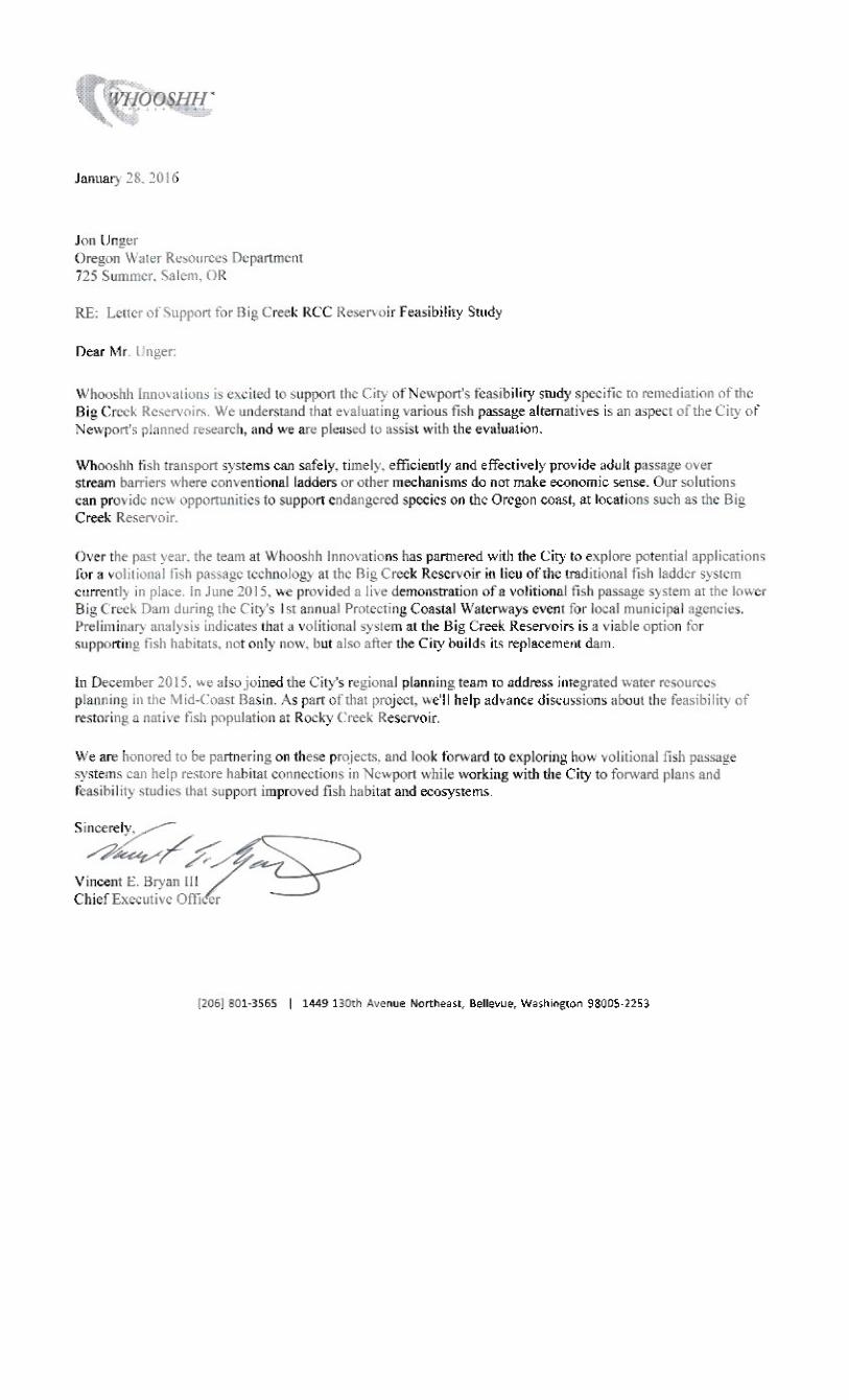
As evidenced by the attached letters of support, other regional entities in support of the City's project include: a)
State Representative David Gomberg's office (District 10); State Senator Arnie Roblan's office (District 5); Oregon
Policy Manager (Charlie Plybon) from the Surfrider Foundation; and CEO (Vincent Bryan III) from the Whooshh
Innovations.

Grant Program Funding Application Form – August 2015 Page 13
9. Identify when matching funds will be secured, from whom, and the dates of matching funds availability.
A total of $674,420 in matching funds from the City will be budgeted in fiscal years 2016 and 2017. These
matching funds will be in the form of cash contributions ($300,000 in FYE16 and $374,420 in FYE17) and in-
kind support for City staff ($30,000 in salary and fringe benefits) and overhead and administrative costs
($39,193, which is approximately 8% of the total grant request).
Matching funds for fiscal year 2016 were approved in April 2015 and were available starting July 1, 2015.
Matching funds for fiscal year 2017 will be secured in April 2016 and available to spend on July 1, 2016.
10. Provide a description of the relevant professional qualifications and/or experience of the person(s) that will play key roles in performing the feasibility study. If the personnel have not been decided upon, include a description of the professional qualifications and/or experience of the person(s) you anticipate will play key roles in performing the feasibility study.
City of Newport Key Personnel
Tim Gross, Director of Public Works for the City of Newport, will manage and oversee this grant. Tim has
worked with the City of Newport for 5 years; 4 years as the Director of Public Works/City Engineer.
Prior to joining the City of Newport, Tim spent 12 years working in the municipal sector and 6 years
running the municipal engineering division for two different engineering consulting firms. He has a
successful track record of managing complex public works projects to completion, on time and within
budget. He also has extensive experience managing large federal, state and local grants, contract
administration, managing consultants, and collaborating with diverse groups to achieve common goals.
Mr. Gross has a BS in Civil Engineering from the University of Minnesota - Twin Cities.
Additional Key Personnel
Most tasks for the proposed project will be completed by the City's Dam Engineer of Record (HDR
Engineering, Inc.), including the same technical team that conducted all previous work on the dam
remediation investigations thus far. In 2012, the City of Newport selected HDR through a competitive
qualifications-based selection process. The proposed work will build upon previous work HDR
conducted on behalf of the City from 2011-2016, including the geotechnical analysis, alternatives
analysis, and initial feasibility report funded by OWRD. Advancing the work will provide an important
level of continuity and continued progress.
Verena Winter, PE, HDR Project Engineer/Project Manager. Verena is a skilled project manager, having
led a variety of projects, including the City of Newport’s CM/GC water treatment facility, the initial
Newport dam explorations project, and other projects in Oregon. She understands the situation with the
Big Creek Dams, having been on this project since the issue was discovered. Her insight, experience,
and leadership will enable her to manage the HDR team and outside assistance to determine the design
parameters and develop practical solutions. Verena holds a B.S. in Engineering Management from

Grant Program Funding Application Form – August 2015 Page 14
Bauhaus University (Germany) and an M.S. in Environmental Engineering from Portland State
University. She has been employed by HDR for 13 years.
Keith Ferguson, PE, HDR Principal Designer. Keith specializes in dam safety, dam engineering, soil and
rock mechanics, foundation engineering, and design, including specialized experience related to the
Cascadia Subduction Zone (CSZ). Since 1978, he has participated in more than 350 civil and mining
engineering projects including evaluation, design and/or construction services for more than 160 dams
and appurtenant structures (e.g. spillways, outlet works, diversion dams), pipelines and tunnel designs.
Keith is a recognized expert in dam safety, seepage, and stability analysis of dams. Keith holds a B.S.
and an M.S. in Civil Engineering from the University of Colorado at Boulder and has 35 years of
experience in the field.
Tia Cavender, MA, GPC, President, Chase Park Grants will provide strategic planning and grant
administrative services for the Big Creek Remediation Project. Tia is a certified grant professional with
more than 15 years of grant experience in various public and private settings. As principal and lead
consultant for Chase Park Grants, Tia counsels local government agencies and technical experts on on
innovative ways to secure funding for water infrastructure projects. She holds two masters degrees
from the University of Colorado, and is a published author and frequent presenter at professional
conferences.
11. If the project concept is ultimately deemed feasible, describe how the project will be implemented. Response should include a tentative funding plan for project implementation (e.g. other state or federally sponsored grant or loan programs) and the project proponent’s track record in implementing similar projects.
The proposed project will be funded through a combination of revenue bonds, general obligation bonds, water rate revenue, government grants, and low-interest loans.
In addition to the traditional sources of financing this type of water storage project, the City will invest in pursuing government grants and low-interest loans. For example, the City could choose to pursue funding under three different public financing programs: a) OWRD Water Supply Development Account loan program, b) the Safe Drinking Water State Revolving Loan Fund, and c) the Clean Water State Revolving Loan Fund for the construction of the fish passage facility.
The City will continue to work with its grants consultant to identify grant opportunities for specific elements of constructing the new dam. For example, if the City decides to incorporate a volitional fish passage technology or hydropower facility, those types of projects can sometimes be funded through grants, which would decrease the amount of money taken out in loans. Several of the design features the City will consider during the design phase of the project (projected for FYE 2018-2019) are likely to be fundable through government and private grant programs.

Grant Program Funding Application Form – August 2015 Page 15
Section B. Unique Criteria Instructions: Address the set of items below that applies to the type of feasibility study that this grant will fund.
Water Conservation or Reuse 1. Water Conservation or Reuse projects that are identified by the Department in a statewide water assessment and
inventory receive a preference in the scoring process. Contact the Department’s Grant Specialist to include your project on the inventory.
2. Explain how the associated project will either: (a) mitigate the need to develop new water supplies and/or (b)
use water more efficiently. Reference documentation and/or examples of the success of similar or comparable water conservation/reuse projects that would be available upon request.
3. Provide a description of: (a) Local, state and/or federal permitting requirements and issues posed by the
implementation of the project associated with the feasibility study and (b) property ownership status within the project implementation area. If permitting or other approvals are not needed please indicate and provide an explanation.

Grant Program Funding Application Form – August 2015 Page 16
Above-Ground Storage Please answer the following three questions BEFORE proceeding: Will the project divert more than 500 acre-feet of surface water annually? Yes No Will the project impound surface water on a perennial stream? Yes No Will the project divert water from a stream that supports sensitive, threatened
or endangered species? Yes No If you answered “Yes” to any of these questions, by signature on this application, you are committing to include the following required elements in your feasibility study. Describe how you intend to address the required elements in your feasibility study:
a) Analyses of by-pass, optimum peak, flushing and other ecological flows of the affected stream and the impact of the storage project on those flows. Task VI of the project will analyze hydrology, infrastructure flows and other ecological flows. The objective of this task is to refine the configuration of the spillway and outlet works of the new dam, and to develop an initial concept for fish passage around the new dam to use in discussions/negotiations with state regulators of the project. This task will include appropriate updates of the estimate of the PMF inflow hydrograph, reservoir routing, and hydraulic analyses of the spillway structure to identify a cost-effective combination of spillway width to dam crest freeboard requirements. The outlet works, including the intake structure, will be designed to meet dam safety as well as operational requirements for both quantity and quality of water released from the reservoir. Fish passage analyses will be based on a possible fish passage facility incorporated into a natural drainage channel in the downstream left abutment area of the new dam.
b) Comparative analyses of alternative means of supplying water, including but not limited to the costs and benefits of water conservation and efficiency alternatives and the extent to which long-term water supply needs may be met using those alternatives. In 2015, the City of Newport commissioned a study to assess the feasibility of five different replacement projects for the Big Creek Dams. The study addressed how to deal with the City's existing dams, and confirmed that the Big Creek Reservoir must be remediated because being out of water or developing another source for water in a timely fashion are not viable options. Of those scenarios, an RCC dam replacement project was prioritized as the most feasible means to secure drinking water for the City into the future. Newport currently delivers water conservation education and is seeking funding to invest in state-of-the-art automated water metering technology to conserve water supply, however it is not anticipated that those projects would lead to any significant additional water source to meet long-term water supply needs. Via the City's regional, place-based planning efforts for the Mid-Coast region, additional water supply and resuse projects may be identified to meet demand on a broader scale. The place-based planning initiative will occur from 2016-19, and will occur in tandem with a Mid-Coast Basin Study, which will focus on the impact of climate change on future water supplies. Through these comprehensive water planning efforts, the City is studying all aspects of water needs and supply in the Mid-Coast Basin and the results of each study will inform the others. The following is a list of stakeholders that are involved in a regional planning initiative to address water supply challenges in the Mid-Coast Basin. Starting in July 2016, this group will meet every other month to advance the development of an Integrated Water Resources Plan for the region. These local partners may be called upon to provide input when looking for stakeholder feedback, and the City will keep them informed as the feasibility study progresses. Because the City of Newport is the largest water provider in the Mid-Coast, local entities are interested in knowing the Big Creek water supply is intact and that its vulnerabilities are being adequately addressed. Additionally, multiple state agencies are interested in seeing this study executed, because what is learned can be applied to other Oregon communities in the future.
c) Analyses of environmental harm or impacts from the proposed storage project.

Grant Program Funding Application Form – August 2015 Page 17
Considerable effort to analyze environmental harm and potential impacts will be undertaken through the scope of work outlined in this proposal. Identifying potential environmental harm will be addressed in Tasks II, VI, IX and X.
d) Evaluation of the need for and feasibility of using stored water to augment instream flows to conserve, maintain and enhance aquatic life, fish life and any other ecological values. Task IX of the scope of work and tasks for this project will evaluate the need for and feasibility of using stored water to augment instream flows with the intent of maintaining and enhancing aquatic life, fish life and other ecological values.
Is the proposed storage project for municipal use? Yes No
If “Yes,” then please describe how you intend to address the following required element in your feasibility study:
e) For a proposed storage project that is for municipal use, analysis of local and regional water demand and the proposed storage project’s relationship to existing and planned water supply projects. The City of Newport Water System Master Plan adopted in 2008 and updated in 2010 projects current and future demand and raw water storage needs. The proposed option being studied in this feasibility study considers projected future need through the year 2030. A concurrent Place-based Planning Study being administrated by the City of Newport will analyze water needs and supply on a regional level, which will inform the report completed as part of the feasiblity study.
Proceed in addressing the following items: 1. Describe to what extent the project associated with the feasibility study includes provisions for using stored
water to augment instream flows to conserve, maintain and enhance aquatic life, fish life or other ecological values. Projects that include the above provisions receive preference in the scoring process. Task IX of HDR's environmental analysis will examine impact to endangered species, stream flows, and required instream flows that will support aquatic life, fish life or other ecologic values. In cooperation with the appropriate agencies the project outcome will comply with all environmental regulations. Based on the required stream flow the dam will be designed to be able to release enough water to maintain the appropriate flows in local streams.
2. Provide a review of: (a) Local, state and/or federal permitting requirements and issues posed by the
implementation of the project associated with the feasibility study and (b) property ownership status within the project implementation area. Newport will prepare preliminary application coordination with USACE, which is anticipated to be the lead federal agency for the project. This will include assessment of necessary compliance programs including the National Environmental Protection Act, Endangered Species Act and Clean Water Act. Additionally, Newport will facilitate a one-day regulatory agency kickoff meeting and site visit in Newport, Oregon. Regulatory agencies with permitting/approval roles may include U.S. Army Corps of Engineers, Oregon Department of State Lands, U.S. Fish and Wildlife Service, National Marine Fisheries Service, Oregon Department of Fish and Wildlife, Environmental Protection Agency, Oregon Department of Environmental Quality, State Historic Preservation Office, and Oregon Water Resource Department. Topics will include the project description, areas of potential impact that relate to resources over which the agencies have regulatory authority, and the regulatory process. The meeting will culminate in an Environmental Compliance Process Framework, including schedule, next steps, roles and responsibilities, and key tasks and milestones. Permits Include: - National Environmental Policy Act (NEPA) - Clean Water Act Section 404/401 and Oregon Removal-Fill permit including: Endangered Species Act Section 7; Magnuson Stevens Fishery Conservation and Management Act; National Historic Preservation Act Section 106; Migratory Bird Treaty Act; Oregon Fish Passage; Coastal Zone Management Act. - Bald and Golden Eagle Protection Act (if required)

Grant Program Funding Application Form – August 2015 Page 18
- Oregon Water Rights - Clean Water Act Section 402 National Pollutant Discharge Elimination System (NPDES) 1200-C - City of Newport Conditional Use Permit - City of Newport Building, Electrical, Plumbing, Mechanical, Sewer/Water Permit - Oregon State Engineer Design Review and Approval. The City of Newport owns all property impacted by the proposed improvement. There are several private property owners who's public road access will be impacted by the project but provisions are being made to address and mitigate these impacts.
Storage Other Than Above-Ground [Including Aquifer Storage and Recovery (ASR)]
Please answer the following three questions BEFORE proceeding: Will the project divert more than 500 acre-feet of surface water annually? Yes No Will the project impound surface water on a perennial stream? Yes No Will the project divert water from a stream that supports sensitive, threatened
or endangered species? Yes No If you answered “Yes” to any of these questions, by signature on this application, you are committing to include the following required elements in your feasibility study. Describe how you intend to address the required elements in your feasibility study:
a) Analyses of by-pass, optimum peak, flushing and other ecological flows of the affected stream and the impact of the storage project on those flows.
b) Comparative analyses of alternative means of supplying water, including but not limited to the costs and benefits of water conservation and efficiency alternatives and the extent to which long-term water supply needs may be met using those alternatives.
c) Analyses of environmental harm or impacts from the proposed storage project.
d) Evaluation of the need for and feasibility of using stored water to augment instream flows to conserve, maintain and enhance aquatic life, fish life and any other ecological values.
Is the proposed storage project for municipal use?
Yes No If “Yes,” then please describe how you intend to address the following required element in your feasibility study:
e) For a proposed storage project that is for municipal use, analysis of local and regional water demand and the proposed storage project’s relationship to existing and planned water supply projects.
Proceed in addressing the following items: 1. Underground storage projects that are identified by the Department in a statewide water assessment and
inventory receive a preference in the scoring process. Contact the Department’s Grant Specialist to include your project on the inventory.

Grant Program Funding Application Form – August 2015 Page 19
2. Provide a review of: (a) Local, state and/or federal permitting requirements and issues posed by the implementation of the project associated with the feasibility study and (b) property ownership status within the project implementation area.

Grant Program Funding Application Form – August 2015 Page 20
V. Match Funding Information Applicants must demonstrate a minimum dollar-for-dollar match based on the total funding request. The match may include a) secured funding commitment from other sources, b) pending funding commitment from other sources, and/or c) the value of in-kind labor, equipment rental, and materials essential to the feasibility study. For secured funding, you must attach a letter of support from the match funding source that specifically mentions the dollar amount shown in the “Amount/Dollar Value” column. For pending resources, documentation showing a request for the matching funds must accompany the application.
In the “type” column below matching funds may include:
In the “status” column below matching funds may have the following status:
• Cash - Cash is direct expenditures made in support of the feasibility study by the applicant or partner*.
• Secured - Secured funding commitments from other sources.
• In-Kind - The value of in-kind labor, equipment rental and materials essential to the feasibility study provided by the applicant or partner.
• Pending - Pending commitments of funding from other sources. In such instances, Department funding will not be released prior to securing a commitment of the funds from other sources. Pending commitments of the funding must be secured within 12 months from the date of the award.
*”Partner” means a non-governmental or governmental person or entity that has committed funding, expertise, materials, labor, or other assistance to a proposed project planning study. OAR 690-600-0010.
Match Funding Source
(if in-kind, briefly describe the nature of the contribution) Type
( ü One) Status
( ü One) Amount/ Dollar
Value Date Match Funds Available
(Month/Year) City of Newport -- FYE2016 (covering expenditures made between 7/1/15 and 6/30/16)
cash in-kind
secured pending
$300,000.00 July 16
City of Newport -- FYE2017 (covering expenditures made between 7/1/16 to 6/30/17)
cash in-kind
secured pending
$374,420.00 July 16
cash in-kind
secured pending
Oregon Water Resources Department -- Water Conservation & Storage Feasibility Grant Program
cash in-kind
secured pending
$460,000.00 July 16
cash in-kind
secured pending
cash in-kind
secured pending
cash in-kind
secured pending
cash in-kind
secured pending
cash in-kind
secured pending
cash in-kind
secured pending

Grant Program Funding Application Form – August 2015 Page 21
VI. Feasibility Study Schedule
Estimated Study Duration: April 1, 2016 to June 30, 2017 Place an “X” in the appropriate column to indicate when each Key Task of the project will take place.
2016 2017 2018
& Beyond
Feasibility Study Key Tasks 2nd Qtr
3rd Qtr
4th Qtr
1st Qtr
2nd Qtr
3rd Qtr 4th Qtr
I Project Management X X X X X
II Survey of New Dam Site and Surrounding Terrain X
III Site Characterization and Explorations X X
IV Design Criteria Memorandum
X
V Engineering Evaluations and New Proposed RCC Dam
X X
VI Hydrology and Spillway, Outlet Works, and Fish Passage Analysis
X X
VII Access Road Preliminary Feasibility
X X
VIII Raw Water Pipeline Preliminary Design
X X
IX Environmental Permitting Assessment
X X X
X Fish Passage and Alternative Review
X X X
XI Cost Estimate and Schedule
X X X
XII Pre- Design Report
X X
XIII Grant Administration, Reporting & Strategic Planning X X X X X
XIV Administrative, Overhead and Facilities Administration X X X X X
Ø Please Note: Successful grantees must include all invoices and identify which key tasks are associated with each invoice when requesting financial reimbursement.

Grant Program Funding Application Form – August 2015 Page 22
VII. Feasibility Study Budget Section A Please provide an estimated line item budget for the proposed feasibility study. Examples would include: labor, materials, equipment, contractual services and administrative costs. Line Items
Number of Units*
(e.g. # of Hours)
Unit Cost (e.g. hourly
rate)
In-Kind Match
Cash Match Funds
OWRD Grant Funds
Total Cost
Staff Salary/Benefits
$30,000.00
$0.00 $0.00 30,000
Contractual/Consulting
$674,420.00 $460,000.00 $1,134,420.00
Equipment (must be approved)
Supplies
Other:
Administrative Costs**
$39,193.00
$39,193.00
Total for Section A $69,193.00
$674,420.00 $460,000.00 $1,203,613.00
Percentage for Section A 6 56 38% 100% * Note: The “Unit” should be per “hour” or “day” – not per “project” or “contract.” Units x Unit Costs = Total Cost ** Administrative Costs may not exceed 10 percent of the total funding requested from the Department Section B If grant amount requested is $50,000 or greater, you MUST complete Section B. Key Tasks in Section B should be the same as the Key Tasks in Section VI (Feasibility Study Schedule).

Grant Program Funding Application Form – August 2015 Page 23
Feasibility Study Key Tasks
In-Kind Match
Cash Match Funds
OWRD Grant Funds
Total Cost
I Project Management $10,000.00 $90,000.00 $50,000.00 $150,000.00 II Survey of New Dam Site and Surrounding Terrain $1,500.00 $70,000.00 $50,000.00 $121,500.00 III Site Characterization and Explorations $1,500.00 $100,000.0
0 $80,000.00 $181,500.00
IV Design Criteria Memorandum $1,500.00 $25,000.00 $25,000.00 $51,500.00 V Engineering Evaluations and New Proposed RCC Dam $1,500.00 $75,000.00 $75,000.00 $151,500.00 VI Hydrology and Spillway, Outlet Works, and Fish Passage Analysis
$1,500.00 $55,000.00 $35,000.00 $91,500.00
VII Access Road Preliminary Feasibility $1,500.00 $35,000.00 $35,000.00 $71,500.00 VIII Raw Water Pipeline Preliminary Design $1,500.00 $35,000.00 $35,000.00 $71,500.00 IX Environmental Review Assessment $0.00 $40,000.00 $10,000.00 $50,000.00 X Fish Passage and Alternative Review $1,500.00 $40,000.00 $0.00 $41,500.00 XI Cost Estimate and Schedule $1,500.00 $25,000.00 $25,000.00 $51,500.00 XII Pre-Designn Report $1,500.00 $40,000.00 $40,000.00 $81,500.00 XIII Grant administration & progress reporting, grant-related technical support, strategic planning
$5,000.00 $44,420.00 $0.00 $49,420.00
XVI Facilities & administrative costs (8% of direct costs) $39,193.00 $0.00 $0.00 $39,193.00
Total for Section B $69,193.00 $674,420.0
0 $460,000.0
0 $1,203,613.00
Totals in Section B must match the totals in Section A

Grant Program Funding Application Form – August 2015 Page 24
APPLICATION CHECKLIST
Instructions: Use this checklist to ensure that your application is complete. An incomplete application will jeopardize your application’s review. This form does not need to be included in your application packet. General If submitting electronically, the preferred format is either a Microsoft word or Adobe pdf
Only one application is included with the packet (other applications must be sent separately). Paper submissions only
The application and attachments are on 8 ½” x 11” paper. The application and attachments are single-sided. The application and attachments are not stapled or bound.
Section I – Grant Information
All questions in this section have been answered. The Grant Dollars Requested and the Total Project Cost mirror the totals shown in Section VII.
Section II – Applicant Information
All contact information for the applicant(s) and fiscal officer is complete and current. The certification is signed by an authorized signer.
Section III – Feasibility Study Summary
A brief summary, of no more than 150 words, is complete. Section IV – Grant Specifics
All questions in Section A have been answered. If the type of feasibility study is water conservation, reuse or storage other than above-ground, you have contacted the Department and requested project be added to the Oregon Water Resources Department’s statewide water assessment and inventory.
All applicable questions for the type of grant requested have been answered. Section V – Match Funding Information
Applicant has identified that at least 50 percent match has been sought, secured or expended. Letters of support are included for “secured” match funding sources. Documentation is included for “expended” match funds. Documentation is included for “pending” match funds.
Section VI – Feasibility Study Schedule
Estimated project duration dates have been supplied. All Key Tasks of the project are listed.
Section VII – Feasibility Study Budget
Section A is complete. Administration costs do not exceed 10 percent of the requested OWRD Grant Funds. If grant amount requested is $50,000 or greater, Section B has been completed. All Key Tasks listed in Section B mirror the Key Tasks listed in Section VI.

ATTACHMENT A
RELEVANT REGIONAL WATER MASTER PLANS

City of Newport Dam Remidiation Feasibility Study Application Attachment A-Water Management Plans, Planning Activities, and Programs
1
11
22
33
44
55
66
77
88
99
1010
1111
1212
AA BB EE FF
Partner Description of Planning DocumentLink to Agency Water Planning
Documents, Programs or Mission Statement
Common Water Management Goals that Support Newport's Feasibility Project
City of Newport City of Newport's Master Water Plan http://newportoregon.gov/dept/pwk/mwp.aspThe City of Newport is looking for long term planning solutions to develop Rocky Creek dam and reservoir for regional storage, increase the storage volume of Big Creek Basin, develop desalination and utilize estuary or ocean water for potable water treatment, create fish passage for Coho Salmon via new technology.
City of Lincoln City, OregonCity of Lincoln City, Oregon Comprehensive Plan, including Lincoln City Estuary Management Plan (1998)
http://www.lincolncity.org/vertical/sites/%7BDDC39B4D-‐9F7A-‐4251-‐AEA0-‐F594E7F89DDB%7D/uploads/Comprehensive_Plan_with_Amendments_for_Web_Posting_-‐_2014(1).pdf
There are identified areas of water quality concern in the Lincoln City area, including: Devils Lake, Schooner Creek, and Drift Creek. (1998, p.39) There is a need for streambank protection; to reduce the amount of nutrients permitted to enter Devils Lake; to improve the sewage treatment facility to prevent further degradation of Siletz Bay and Schooner Creek; to explore alternatives to the Schooner Creek sewage outfall; and preservation of wildlife areas such as stream spawning beds and eagle's nests.
Lincoln City supports programs to resolve conflicts between the preservation of sensitive wildlife habitats and conflicting uses, with a goal to conserve, protect, and enhance the Siletz Bay Estuary.
City of Toledo Master Water Plan http://www.cityoftoledo.org/water-‐master-‐plan/Water Treatment and Water Storage Needs (e.g., Siletz Intake and Pump Station, Ollala Reservoir Pipeline Crossing, Skyline Drive Storage Tank). The City is also developing a Water Master Conservation Plan beginning in January 2016.
City of Depoe Bay Water Management and Conservation Planhttp://filepickup.wrd.state.or.us/files/Publications/WMCP/Requested%20Files/Depoe%20Bay/Depoe%20Bay_Draft%20WMCP_1999.pdf
The City is currently developing an updated Water Master Conservation Plan. The City also has a Water Management Plan.
Seal Rock Water District's Master Water Plan http://www.srwd.org/pdf/Master%20Plan.pdf
The Seal Rock Water District (SRWD) is located in Lincoln County, Oregon, approximately in the center of the County coastline. The District serves the coastline between the cities of Waldport and Newport and at no point extends more than 1.5 miles inland from the beach. The current SRWD Boundary encompasses 6,505 acres, or 10.2 square miles. The district is looking into options to treat and supply their own water. Seal Rock currently purchases its water from Toledo.
Seal Rock Water District's Water Management and Conservation Plan
http:F11//filepickup.wrd.state.or.us/files/Publications/WMCP/Requested%20Files/Forecast_WMCPs%202012-‐2014/Seal%20Rock%20Water%20Dist_Final%20Revised%20WMCP_3_3_2014.pdf
This plan summarizes much of the information contained in the Seal Rock Water Master Plan and its two amendments and it includes data to support the requirements of outlined in OAR 690-‐086-‐0125(1)–(4).
Port of Newport Port of Newport http://www.portofnewport.com/index.php Mission statement: To build and maintain waterfront facilities, and promote/support projects and programs in cooperation with other community organizations and businesses that will retain and create new jobs and increase community economic development. Newport Fisheries Center: Mixed use facility that supports the fishing industry by acting as a "hub" for related activity.
The Confederated Tribes of the Siletz Indian
The Confederated Tribes of the Siletz Indians, 2005-‐ 2015 Comprehensive Plan
http://www.ctsi.nsn.us/uploads/downloads/ComprehensivePlan/Ctsi%20Comprehensive%20Plan%202005-‐15%20Intro.pdfhttp://www.ctsi.nsn.us/uploads/Ctsi%20Comprehensive%20Plan%202005-‐15%20Goals%20%26%20Objectives.pdf
The Tribal staff work with various agencies through out the Northwest on environmental issues including working with the relicensing of Hydro Projects. They also have several other aquatics projects such as a fish hatchery, eel passage, and work on the Willamette Falls. Water quality is a focus so is leaving water instream for fish. Also expressed interest in including an assessment on projected tourism in the Basin.
Lincoln County Water Needs Analysis prepared by WHPacific and GSI (2008)
http://www.oregon.gov/owrd/LAW/docs/GrantSum/GA0032_09_Polk_County_Complete_App.pdf
The purpose of this report is to quantify currently available water resources in Lincoln County and evaluate whether existing sources can adequately meet future water demand through 2050. This study will: 1) document current average day and maximum day water demand; 2) forecast future water demand based on growth assumptions; and 3) compare currently available water supply to the projected future water demand.
Lincoln County Multi-‐Jurisdictional Natural Hazards Mitigation Plan (2009)
http://www.co.lincoln.or.us/sites/default/files/fileattachments/emergency_management/page/3785/nhmp.pdf
Lincoln County developed this multi-‐jurisdictional Natural Hazard Mitigation Plan in an effort to assist Lincoln County, Lincoln City, Depoe Bay, Newport, Toledo, Waldport and Yachats to reduce the risk from natural hazards by identifying resources, information, and strategies for risk reduction. It will also help guide and coordinate mitigation activities throughout the County.
Midcoast Watershed Council, Rock Creek (Siletz) Watershed Assessment Final Report
https://nrimp.dfw.state.or.us/web%20stores/data%20libraries/files/Watershed%20Councils/Watershed%20Councils_172_DOC_MCWC%20Rock%20Creek%20(Siletz)_v1.PDF
The residents of Rock Creek were interested in developing a science-‐based management and monitoring plan to conserve the resources in the Rock Creek watershed (a tributary of the Siletz River). The primary goals of this assessment were to inventory and characterize watershed components and evaluate watershed processes that influence abundance and distribution of salmonids and other valued wildlife. Products of this assessment include monitoring and management recommendations, summary and a base map with GIS data layers, identification of information gaps and a plan for addressing those gaps.
Seal Rock Water District
MidCoast Watersheds Council
Lincoln County, OR

City of Newport Dam Remidiation Feasibility Study Application Attachment A-Water Management Plans, Planning Activities, and Programs
2
11
22
AA BB EE FF
Partner Description of Planning DocumentLink to Agency Water Planning
Documents, Programs or Mission Statement
Common Water Management Goals that Support Newport's Feasibility Project
1313
1414
1515
1616
1717
1818
1919
2020
2121
2222
2323
An Approach To Limiting Factors Analysis and Restoration Planning In Sixth Field Sub-‐Watersheds
http://www.midcoastwatershedscouncil.org/images/assessment/limiting-‐factors/Methodology.pdf
This document describes an approach used in conducting limiting factor analyses of Coho salmon habitats in five small mid-‐coastal Oregon 6th field watersheds, including the Steere Creek (Siletz River Basin)and Rock Creek (Devils Lake drainage). The project was funded by the Oregon Watershed Enhancement Board (OWEB), and was administered by the MidCoast Watershed Council (MCWC).
Limiting Factors Assessmentand Restoration Plan Rock Creek Tributary to Devil’s Lake Lincoln County, Oregon (2003)
http://www.midcoastwatershedscouncil.org/images/assessment/limiting-‐factors/Rock%20Creek.pdf
Final Report Prepared for MidCoast Watershed Council in 1999. The report surveyed estuarine wetland sites in the Alsea and Yaquina basins and prioritized sites for protection and restoration activities.
Yaquina and Alsea River Basins Estuarine Wetland Site Prioritization Project (1999)
http://www.midcoastwatershedscouncil.org/images/assessment/1999_Tidal_Marsh_Assessment.pdf
Project to better understand the status and condition of streams and watersheds of the Yaquina and Alsea rivers.
MidCoast Sixth Field Watershed Assessment Final Report (2001)
http://www.midcoastwatershedscouncil.org/images/assessment/2001_6th-‐Field-‐Assessment.pdf
The study area for this assessment is composed of the Alsea, Salmon, Siletz, Yachats, and Yaquina River watersheds and those watersheds that drain directly to the ocean between Cascade Head and Cape Creek at Heceta Head (Ocean Tributaries).
MidCoast Watersheds Council Annual Report http://www.midcoastwatershedscouncil.org/index.php/what-‐we-‐do/annual-‐reports
The MidCoast Watersheds Council is a local non-‐profit organization dedicated to improving the health of streams and watersheds of Oregon’s central coast so they produce clean water, rebuild healthy salmon populations, and support a healthy ecosystem and economy. The Council works in an area of nearly one million acres, including all streams draining from the crest of the Coast Range to the Pacific, from the Salmon River to Cape Creek at Heceta Head.
Office of the Governor, State of Oregon
Executive Order 15-‐09: Directing State Agencies to Plan for Resiliency to Drought, to Meet the Challenge that a Changing Climate Brings
http://www.oregon.gov/gov/Documents/executive_orders/eo_15-‐09.pdf
Governor Kate Brown responded to Oregon’s drought by signing Executive Order 15-‐09 Directing State Agencies to Plan for Resiliency to Drought, to Meet the Challenge that a Changing Climate Brings on July 27, 2015. The goal of the actions outlined in the Executive Order is to reduce non-‐essential water use in all state-‐owned facilities by an average 15 percent or more by December 31, 2020, and to work with private building owners who lease facilities to state agencies to reduce non-‐essential water consumption at their buildings.
Report to Governor Kate BrownImplementation of Executive Order No. 15-‐09 Directing State Agencies to Plan for Resiliency to Drought (November 2015)
http://www.oregon.gov/owrd/docs/FinalReportDroughtEO.pdf
The goal of the actions outlined in the Executive Order is to reduce non-‐essential water use in all state-‐owned facilities by an average 15 percent or more by December 31, 2020, and to work with private building owners who lease facilities to state agencies to reduce non-‐essential water consumption at their buildings. This document is the first progress report to Governor Kate Brown.
Oregon's Integrated Water Resources Strategy (2012) http://www.oregon.gov/owrd/LAW/docs/IWRS_Final.pdf
State and place based planning, water management and development, protection of public health and ecological health, and stable funding. Our place based planning effort was modeled to achieve the goals outlined in the states strategy.
Oregon Department of Fish and Wildlife
Oregon Plan for Salmon and Watersheds Oregon Coast Coho Assessment Habitat Prepared by Oregon Department of Fish and Wildlife (2005)
https://nrimp.dfw.state.or.us/crl/Reports/AI/Oregon%20Coast%20Coho%20ESU%20Habitat%20Assessment.pdf
In this report, the status and trend of instream physical habitat conditions in the Oregon Coastal Coho ESU are assessed from ten variables collected by the ODFW habitat monitoring program from 198-‐2003. Habitat conditions are described at the scale of the ESU, four monitoring areas within the ESU, and by four land use categories (agriculture, urban, private forest, and public forest). The condition of habitat is compared among monitoring areas or land use categories.
Identification of HistoricalPopulations of Coho Salmon(Oncorhynchus kisutch)in the Oregon CoastEvolutionarily Significant Unit (2007)
http://www.nwfsc.noaa.gov/assets/25/478_08302007_104459_HistPopsCohoTM79Final.pdf
The Oregon Coast Evolutionarily Significant Unit (ESU) of Coho salmon was listed as threatened under the U.S. Endangered Species Act in 1998. This report identifies species and ESU delisting goals, characterizes fish/abundance, identifies factors for decline and limiting factors for the ESU, identifies early actions that are important for recovery, and identifies research, evaluation, and monitoring needs. The report also includes climate data for the Oregon Coast ESU.
Final Assessment of NOAA Fisheries’ Critical Habitat Analytical Review Team (CHART) For the Oregon Coast Coho Salmon Evolutionarily Significant Unit (2007)
http://www.westcoast.fisheries.noaa.gov/publications/protected_species/salmon_steelhead/critical_habitat/ch-‐oregon_coast_coho_chart_report_2007.pdf
This report summarizes the results of the critical habitat analytical review team (CHART) charged with analyzing the best available data to assess biological information relevant to making a critical habitat designation for the Oregon Coast Coho salmon Evolutionarily Significant Unit (ESU).
Oregon Water Resources Department
National Oceanic and Atmospheric Association
MidCoast Watersheds Council

ATTACHMENT B
DAM ALTERNATIVES OVERVIEW
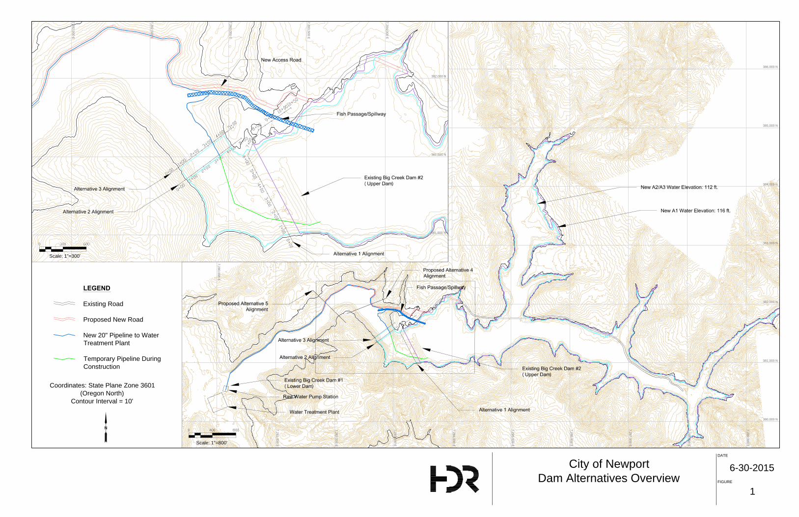
DATE
FIGURE
6-30-2015
1
City of Newport
Dam Alternatives Overview
Scale: 1"=800'
Scale: 1"=300'
LEGEND
Existing Road
Proposed New Road
New 20" Pipeline to Water
Treatment Plant
Temporary Pipeline During
Construction
380,000 N
381,000 N
382,000 N
383,000 N
384,000 N
385,000 N
386,000 N
7,289,000 E
7,288,000 E
7,287,000 E
7,286,000 E
7,285,000 E
7,284,000 E
7,283,000 E
7,282,000 E
7,281,000 E
7,280,000 E
7,284,000 E
7,283,500 E
7,283,000 E
7,282,500 E
7,282,000 E
382,000 N
381,500 N
381,000 N
Coordinates: State Plane Zone 3601
(Oregon North)
Contour Interval = 10'

ATTACHMENT C
ALTERNATIVE 2 RCC DAM

Feet
0 40 80
City of Newport
Alternative 2 RCC Dam
Excavation to
Assumed Bedrock
Existing
Ground Surface
Approximate
Excavation Footprint
Contour Interval = 2'
6-30-2015
3
Excavation to
Assumed Bedrock
Ground Surface
Intake Tower
36" Outlet Pipe
Gate House
20" Pipeline to WTP
for Water Supply
Dam Safety Outlet
Reinforced Concrete Ogee
Spillway
Conventional Concrete
Downstream Facing
Conventional
Concrete Shear Key
and Heel
Conventional
Concrete Upstream
Facing
Drainage Gallery
Drain Holes
Conventional Concrete
Leveling
Roller Compacted Concrete
(RCC)
Outlet Works
Intake Tower
36" Outlet Pipe
Excavation to
Assumed Bedrock
Ground
Surface
Reinforced Concrete
Crest Road and
Parapet Wall
Conventional Concrete
Downstream Facing
Water Quality
Inlet Ports
Conventional Concrete
Leveling
Roller Compacted Concrete
(RCC)
Backfill
Gate
House
BOR Type VI Stilling Basin
Dam Safety Outlet
36" Outlet Pipe
Intake Tower
Grout Curtain
Feet
0 15 30
Feet
0 15 30
Feet
0 20 40
Conventional
Concrete Outlet Pipe
Encasing
Dam Crest
Access Road
Approximate Excavation
For Dam Construction
AA
BC
C
B
Spillway Training Wall
Stilling
Basin
Overflow
Spillway
Spillw
ay C
hute
Backfill to
Elev 45±
Backfill to
Elev 45±
DATE
FIGURE
Backfill to
Elev 45±
USBR Type IV
Stilling Basin
RipRap lined transition
to downstream channel
Embankment Volume:
Excavation Volume:

ATTACHMENT D
PHASE 3 SEISMIC EVALUATION OF BIG CREEK DAMS #1 AND #2
REPORT EXCERPT

Seismic Evaluation of Big Creek Dams No. 1 and 2
Phase 3 – Engineering Evaluation and Corrective Action Alternatives
| 1
Executive Summary
HDR Engineering Inc. (HDR) has completed the Phase 3 assessment of the static and
seismic stability of Big Creek Dam No. 1 (BC 1) and Big Creek Dam No. 2 (BC 2) for the City
of Newport (City). This assessment included 1) an update of the seismic hazard
characterization and characteristic earthquake time histories at the site based on the most
recent research; 2) additional site characterizations including borings and cone penetration
testing, sampling and laboratory testing; 3) analysis and evaluation of the field and laboratory
test results; 4) developing a more detailed and comprehensive geologic model of the two
dam sites along with generalized profiles and cross-sections for engineering evaluations; 5)
an update of the previously completed seepage, static and post-earthquake stability analysis;
6) evaluating the expected seismic response (deformations) of both existing dams to a range
of potential earthquakes at the site; 7) developing and evaluating alternatives for corrective
actions for BC 1 and BC 2; 8) development of decision level cost estimates for the corrective
action concepts; and 9) providing a preliminary environmental permitting overview for the
corrective action concepts. The findings from this evaluation are summarized in this report.
Verification of Seismic Response Deficiencies
The static and post-earthquake stability and seismic response analyses presented in this
report have confirmed seismic deficiencies at both existing dams (BC 1 and BC 2). The
estimated deformation of each dam in response to potential earthquakes suggests a high
potential for significant damage and/or failure to occur.
Two methods of evaluation have been used to assess potential deformations including 1) the
development of a numerical model based on an industry accepted “Newmark” analysis
methodology, and 2) an empirical correlation between seismic loading and observed
deformations at a variety of existing dam sites (i.e. case history data) The estimated crest
deformations for both dams based on these methods were reasonably similar. The
numerical evaluation method results reflect the more rigorous approach and predict larger
potential deformations consistent with the unusually long duration of ground shaking that
would be associated with a Cascadia earthquake event.
The selection of an appropriate earthquake loading conditions for dam safety evaluations
and design represents a critical aspect of the study. The Cascadia Subduction Zone (CSZ)
hazard is substantial (Richter Magnitude 9) and the understanding of this magnitude of
event, and the corresponding peak ground accelerations, and duration of strong shaking that
would result at the Newport dam sites is continuing to evolve throughout the industry. Based
on the current standard of practice at both the state and federal levels of jurisdiction in the
northwest, ground motions with expected recurrence intervals of up to 4975-years have been
used as the basis of our assessment and design presented in this report.
Alternatives for Corrective Actions
Based on the outcome of the stability analysis and evaluation, HDR developed three different
alternatives to provide a solution for both dams that would provide adequate dam safety and
for a continuous drinking water supply following a significant earthquake event. The repairs
for BC 1 would be very costly for the gained benefit as the dam does not hold enough water
Seismic Evaluation of Big Creek Dams No. 1 and 2 Phase 3 – Engineering Evaluation and Corrective Action Alternatives
2 |
to pay off the costs of its remediation. A decision was made together with the City to not
proceed with any corrective actions for BC 1.
Alternative 1 consists of a raise of BC 2 to include the current water storage from BC 1,
recovery of storage in the upper reservoir due to sediment accumulation, and increased
storage for future water demands in the city. This alternative presents some challenges as
the existing reservoir and outlet works would need to stay operational during construction.
The foundation excavation volume for this alternative is very large and sufficient construction
material would have to be found to replace the excavated foundation material as well as the
new embankment section. Because of the potential for significant deformations of the
upstream slope of the dam, a new outlet structure would have to be built through the right
abutment of the existing dam. Further, a spillway and fish ladder would need to be
constructed. This alternative is doable but does not present the most cost effective and most
feasible option.
Alternative 2 consists of a new roller compacted concrete (RCC) dam at a location just
downstream of BC 2 where the topography of the valley narrows the most.
Alternative 3 consist of a new embankment (earthen) dam at the same location as
Alternative 2.
Both alternatives 2 and 3 are acceptable solutions for corrective actions and represent a
“least cost” solution for the project purposes outlined above.
Decision Level Estimates of Probable Costs
Decision level cost estimates were developed for Alternatives 2 and 3. At this time, the costs
exclude some important project elements as the extent and dimensions of those elements is
unknown at this stage of the project. They also include some significant cost uncertainties
and hence are not suitable for establishing project funding. Future preliminary design will be
required to provide the basis for a funding level cost estimate. The Preliminary design
should include such elements as the spillway for Alternative 3, fish ladder, access road, and
pipeline to the water treatment plant.
From a decision making standpoint, the cost estimates show that both Alternatives are
similar and that a decision on the preferred dam type and configuration can be based on a
number of other considerations such as long term operation and maintenance, owner
preference and cost risk uncertainties.. Based on discussions with the City, Alternative 2 is
recommended for preliminary design. Should a significant issue be identified with this
Alternative during the early stages of preliminary design, Alternative 2 can be pursued as the
preferred configuration.
Conclusions and Recommendations
Alternative 2 (RCC dam) provides a number of potential advantages to the City such as a
relatively short construction timeline, proven seismic performance of concrete dams, lower
cost uncertainty, smaller project impact footprint, and preferred spillway configuration
HDR recommends moving forward with a preliminary design of Alternative 2 (RCC dam).
The preliminary design will include both geophysical, and boring characterization of the
proposed site, a budget level cost estimate, environmental permit preparation, access road
refinement, and additional modeling which is required by the state.

Seismic Evaluation of Big Creek Dams No. 1 and 2
Phase 3 – Engineering Evaluation and Corrective Action Alternatives
| 3
1 Introduction
HDR began working with the City of Newport in 2009 on the design and construction of a
new water membrane filtration treatment plant. The water treatment plant is supplied with
water stored in two man-made reservoirs in Big Creek, denoted Big Creek Dam No. 1
(BC 1) and Big Creek Dam No. 2 (BC 2). BC 1 reservoir is adjacent to the new treatment
plant, and BC 2 reservoir is located approximately 1 mile upstream. These reservoirs
were formed by the construction of an earthen dam at each location.
During construction of the new plant, geotechnical explorations were performed for the
design of a new intake structure located in the BC 1 reservoir. A single boring drilled in
October 2011 by Foundation Engineering, Inc. (FEI) showed foundation material to
generally consist of very soft to soft clayey silt and very loose to loose silty sands. The
initial boring and engineering evaluation also identified that the loose silty sand soils
have a potential for liquefaction during a seismic event and that further dam safety
related evaluations were indicated.
BC 1 is 315 feet long with a maximum height of 21 feet. The reservoir normally
impounds 190 acre-feet of pool. The dam was designed by CH2M of Corvallis, Oregon
and constructed by the City of Newport Public Works Department in 1951. Available
design drawings depict the dam as a homogeneous compacted clay dam with
embankment slopes of 1 vertical (V) on 3 horizontal (H) upstream and 1V on 2H
downstream. Drawings show a 5-foot-thick granular drainage zone at the foundation
level of the downstream third of embankment.
BC 2 was originally constructed in 1969 and modified and raised in 1975 and 1976. The
dam was to be raised by 17 feet to an overall height of 56 feet and a length of 450 feet.
The dam is shown with a central core trench and a downstream drainage system.
Foundation materials are described as medium to stiff sandy silts over a weak siltstone.
The CH2M-Hill, (CH2M-Hill, Predesign Report for the Raising of Big Creek Dam No. 2,
City of Newport, Oregon, 4 Sep 1974), states that a seismic coefficient of 0.1 g was used
for a pseudo-static analysis and a bedrock acceleration of 0.18 for a Newmark analysis
which was used to estimate potential displacement during a seismic event.
1.1 Project Background
As a result of the potential dam safety-related concerns identified in the initial boring at
the site, the City requested HDR perform a seismic evaluation of the embankment dams
for both BC 1 and BC 2 reservoirs. This evaluation was completed in 2011 and 2012
and consisted of site investigations to characterize the dams’ earthen and foundation
materials, a probabilistic seismic hazard analysis (PSHA), a geologic hazard
assessment, and geotechnical analyses to determine the stability of the dams in the
event of potential seismic events. The initial site investigation and characterization
program consisted of borings, cone penetration testing, seismic refraction geophysical
testing, and laboratory testing.

Seismic Evaluation of Big Creek Dams No. 1 and 2 Phase 3 – Engineering Evaluation and Corrective Action Alternatives
4 |
1.2 Previous Report and Results
In February 2013, HDR submitted the “Big Creek Dam No. 1 and No. 2 Preliminary
Geotechnical Investigation and Seismic Evaluation” report (February 2013 Report). This
is subsequently referred to as the Phase 2 investigation program. The report described
the site characterization program, the soils testing program, an evaluation of the results,
and the engineering analysis for the two dams. The report included regional and site
geology, seismic hazards, preliminary models of subsurface conditions, results of the
seepage and stability analysis, and recommendations for the two dams.
The recommendations included the following:
The seismic safety of BC 1 was estimated to be marginal while a significant safety
deficiency was identified at BC 2.
Additional site characterizations were recommended in order to further refine
stratigraphic models of the existing structures, confirm the mineralogical origin of the
soils and the corresponding reasons for the low densities, further refine the
engineering properties and behavior of the foundation and embankment soils, and
reduce uncertainties that occurred with the limited data sampling conducted. The
additional data would also be used to support alternative design concepts.
An update of the time histories was necessary as the U.S. Geological Survey
(USGS) guidelines and regulations had changed due to the available research data
from the most recent Chile and Japan subduction zone earthquakes. This was
necessary to create alternatives that comply with the most recent safety standards
and available design criteria.
Additional laboratory testing was recommended to further examine the soil
characteristics of the additional site explorations and refine the soil properties.
Further engineering analyses were recommended to include the newly analyzed data
and use it for computer models to simulate the behavior of the dams in case of a
seismic event.
Based on the findings of the additional analysis, corrective actions would be
developed to mitigate the stability problems of the two dams. A range of rehabilitation
concepts and methods was recommended for the next phase of the project.
The results presented in this report have subsequently been described as the Phase 2
investigation program.
1.3 Scope of Current Phase
Beginning in July 2014, HDR performed additional (Phase 3) site characterization and
further engineering evaluations including concept design/alternative evaluations to
reduce the risk of a dam failure for BC 1 and BC 2 in case of a seismic event. The
original Phase 3 scope for the project included: additional site explorations, sampling
and laboratory testing at both the BC 1 and BC 2 sites; updating the seismic hazard
characterization of the site; developing site hydrology that would be used to assess
spillway requirements for modified dam configurations; establishing analysis parameters
through integrated evaluation of both the field and laboratory test data; updating the

Seismic Evaluation of Big Creek Dams No. 1 and 2
Phase 3 – Engineering Evaluation and Corrective Action Alternatives
| 5
previously completed seepage, static and post-earthquake stability analyses; evaluating
new seismic response with Newmark Sliding (Rigid) Block analysis based on a more
comprehensive geologic model of the site; and developing and evaluating alternatives for
corrective actions at both BC 1 and BC 2.
HDR performed initial engineering analysis for existing conditions and for alternative
configurations involving corrective actions to mitigate the seismic stability problem for
both dams in order to develop opinions on the preferred configuration of corrective
actions. During the progress of the work, based on input from the City, HDR modified
the approach of the corrective action alternatives to include three potential configurations
at or near the BC 2 site that each included the following components of water storage
along with remediation of dam safety deficiencies:
Upper Reservoir Storage: 970 acre-feet
Lower Reservoir Storage transfer: 200 acre-feet
Upper Reservoir Sediment Recovery: 100 acre-feet
Future Storage Allowance: 1,000 acre-feet
Total Storage: 2,270 acre-feet
The original scope of work also included a risk-based assessment to establish the
appropriate level of seismic loading to be included in the design, a review of
environmental conditions and clearances that would be needed, consultation with the
City Engineer and the State Engineer at the Oregon Water Resources Department for
dam safety, and preparation of appropriate reports and decision documents.
As a result of the revised storage and configuration requirements for the project
described above the risk-based assessment to establish the appropriate seismic design
criteria was removed and a preliminary design criteria of a 4,750-year seismic event was
used to configure the alternatives. In addition, the scope of engineering analyses was
modified in order to complete the engineering analyses within existing budget limits. The
approach to engineering analyses was made in order to include evaluation of the
concrete dam alternative by: 1) using a Newmark deformation analysis in lieu of a FLAC
analysis for the embankment alternatives, and 2) performing a response spectrum
evaluation of the concrete dam configuration.
1.4 Project Team
The Project team for the Phase 2 studies presented in this report included HDR as the
principal engineer, with support from Cornforth Consultants (Cornforth), the Geotechnical
Earthquake Engineering Department of the University of California, Davis (UC Davis),
and Marine + Earth Geosciences (MEG).
Cornforth completed the update to the seismic hazards to the most current USGS
standards and also supported the field explorations and index property laboratory testing
for the samples.
UC Davis provided support to develop the laboratory testing plan and interpretation of
field and laboratory testing data based on their research experience.
MEG provided the laboratory testing for all undisturbed samples.

Seismic Evaluation of Big Creek Dams No. 1 and 2 Phase 3 – Engineering Evaluation and Corrective Action Alternatives
6 |
HDR developed and directed the field and laboratory testing program, provided geologic
models of the existing dams along with the engineering evaluation of the dams. Based
on the outcome of the engineering analysis, HDR developed concept designs for the
Alternatives described in this report along with decision level cost estimates. Three
alternatives to mitigate the seismic hazard were identified. HDR also provided a
preliminary review of project hydrology, and environmental review which entails a list of
the necessary environmental permits associated with the proposed alternatives.
Key HDR personnel for this project included the following:
Verena Winter, P.E. Project Manager
Keith A. Ferguson, P.E. Principal Engineer
Scott Anderson, P.E. Senior Geotechnical Engineer
John Charlton, P.G. Senior Engineering Geologist
Andrew Little, EIT Project Engineer
Michael Woodward, EIT Project Engineer
Richard Hannan, P.E. Technical Review
Farzad Abedzadeh, PE, PhD Senior Dam Structural Analyst

Seismic Evaluation of Big Creek Dams No. 1 and 2
Phase 3 – Engineering Evaluation and Corrective Action Alternatives
| 7
2 Phase 3 Site Characterization and Evaluation Results
Additional site characterizations and evaluations were performed during Phase 3 and are
summarized below.
2.1 Seismic Hazards and Time Histories
A seismic hazard update in support of this phase was performed based on information
from recent large subduction zone earthquakes and newly released probabilistic seismic
hazard maps as well as the newly released updated regional seismicity and potential
ground motions from USGS’s 2014 Probabilistic National Seismic Hazard Maps (NSHM)
and supporting documentation. The newer information was compared to the results of
the February 2013 report and Cornforth provided additional seismic hazard information
and acceleration time history parameters for the site evaluation. The revised seismic
hazard analyses and updated information are provided in Appendix A.
2.2 Site Explorations
Subsequent to the initial boring completed at the BC 1 site, field investigations to
characterize the site subsurface conditions have occurred during two additional phases.
The initial boring at BC 1 occurred in 2010 when the problem was discovered. The
results of that boring were included in the previous report from February 2013. The
second phase of explorations occurred in December 2011 through January 2012. These
investigations consisted of mud rotary and hollow stem auger drilling, cone penetrometer
testing, and a surface geophysical survey. The results of Phase 2 were included in the
report from February 2013 as well. The third phase of investigations occurred in
November/December 2013 and is described in this report. This Phase 3 program
consisted of mud rotary drillings and cone penetrometer testing, disturbed and
undisturbed sampling, and laboratory testing. A detailed discussion of the Phase 3
program of field investigations is presented in Appendix B.
2.2.1 Boreholes and Cone Penetration Testing Results
The 2013 investigations consisted of additional borings, and cone penetration testing at
the BC 1 and BC 2 sites. The drilling work was performed by Western States Drilling and
the cone testing was done by Northwest Geophysical Associates, Inc. as a subcontractor
to Western States. The borings and cone soundings were necessary to better define the
stratigraphy at the site including a better definition of the top of rock, and to collect
disturbed and undisturbed soil and rock samples. Continuous Standard Penetration
Testing (SPT) was performed in all bore holes. In addition to the SPT data, the
procedure also allowed for the collection of disturbed soil samples. Further, undisturbed
samples were obtained with 3-inch-diameter thin-walled Shelby tube samples at selected
depths in the borings using a fixed piston sampler. The disturbed and undisturbed
samples were needed for the second phase of laboratory testing.
The subsurface materials encountered in the BC 1 exploratory bore holes generally
consisted of approximately 60 feet of silty sand, clayey silt, and silty clay alluvium
Seismic Evaluation of Big Creek Dams No. 1 and 2 Phase 3 – Engineering Evaluation and Corrective Action Alternatives
8 |
overlying Nye Mudstone. The subsurface materials encountered in the BC 2 exploratory
bore holes generally consisted of approximately 10 to 15 feet of silty sand and clayey silt
alluvium, overlying approximately 30 to 35 feet of silty sand, clayey silt, and silty clay
alluvium/colluvium, overlying Nye Mudstone.
Two Seismic Cone Penetration Test (SCPTu) soundings with pore pressure
measurements were advanced at the BC 1 site and four were advanced at the BC 2 site.
The two SCPTs at BC 1 and two SCPTs at BC 2 were advanced near existing borings to
provide a comparison between the SCPT data and SPT data. The SCPT tip resistance,
sleeve friction, and pore water pressure was measured at 2-inch increments as the
SCPT instrument was pushed at a constant rate of 2 centimeters/second. Shear wave
velocity and pore water pressure dissipation measurements were conducted at selected
depths at all locations. Each of the four SCPTu explorations at BC 2 showed lower
permeabilities at the upper elevations and slightly higher permeability with depth. All
SCPTs were terminated at refusal. SCPT data is presented in Appendix B.
2.2.2 Laboratory Testing Results
Laboratory testing of soil samples collected from the 2013 site exploration were taken to
MEG in Vancouver, British Columbia and, in conjunction with guidance from Dr. Jason
DeJong at the University of California at Davis and HDR, a laboratory test program was
developed.
The laboratory testing program was developed using Stress History and Normalized Soil
Engineering Properties (SHANSEP) framework, which accounts for the stress history
and the anisotropy of the soils due to different modes of shearing that are encountered
during slope stability analysis. The three modes are triaxial extension near the toe of the
slip surface, triaxial compression at the head of the slip surface, and direct simple shear
along the base and transitions of the slip surface.
Radiography (x-ray) of the undisturbed samples was performed to evaluate the suitability
of the samples for testing and develop a testing plan for the range of samples taken
during the exploration. Consolidation testing consisting of load-increment ratio (LIR) and
constant strain rate (CSR) consolidation methods were used to evaluate the sample
disturbance and stress history profile with depth. Selected samples were then evaluated
in shear by direct simple shear (DSS), isotropically consolidated triaxial compression
(CIUC) testing. The SHANSEP method assumes that the behavior of the soil can be
represented by the undrained shear strength, Su, divided (normalized) by the effective
overburden pressure, ’v0, with other parameters to take into account the
overconsolidation ratio (OCR) and the shape of the curve, the exponent m. To evaluate
the suitability of the SHANSEP framework to represent the behavior of the soil, samples
were consolidated to three to four times the estimated pre-consolidation pressure
identified in consolidation tests corresponding to an OCR of 1 (the soil is considered
normally consolidated at this OCR). Several of the test samples were consolidated to
three to four times the pre-consolidation stress and then unloaded to an overburden
stress that corresponds to a known OCR, typically an OCR of approximately 4. The plots
of these tests can be found in Figure D-1.5 in Appendix D. Individual test results are
also found in this Appendix D. The result is a framework with which to evaluate the
strength of the soil with depth and OCR.

Seismic Evaluation of Big Creek Dams No. 1 and 2
Phase 3 – Engineering Evaluation and Corrective Action Alternatives
| 9
Cyclic DSS (CycDSS) testing was performed to evaluate strength degradation with cyclic
loading. Based on the CycDSS testing the soils appeared to have little to no strength
degradation to 100 cycles and Post-CycDSS testing yielded soil strengths nearly the
same as samples tested in static DSS. A strength reduction was evaluated by using
Figure D-1.8 in Appendix D and the average plasticity index from the soils encountered.
A reduction of 20 percent was conservatively used to degrade the strength properties
from the peak undrained strength to the post-earthquake undrained strength.
2.3 Engineering Parameters and Assessment
The parameters developed in the laboratory testing program and those calculated and
estimated based on SCPTu were used for assessing the existing dams with respect to
seismic loading. Permeability values were evaluated from SCPTu dissipation testing and
laboratory consolidation testing results. A set of upper and lower bound permeability
values were used in the seepage analysis and subsequent stability analysis of the dams.
The upper and lower bound values did not result in significantly differing Factors of
Safety (FOS) for stability.
Based on the laboratory testing program and the in-situ testing which was calibrated to
the laboratory testing data, the slope stability models were updated to use the SHANSEP
parameters for the alluvial soils in the foundation. A maximum OCR of 4 was used,
neglecting the higher OCR values in some samples that were a result of desiccation and
shear stress bias at the toes of the dam where samples were collected and SCPTu
testing performed. Figure D-1.4 of Appendix D shows the variation of OCR with depth for
the free field environment. The dams themselves increase the overburden stress of the
foundation soils and thus reduce the OCR of the underlying soils.
Use of the Field Shear Vane (FSV) and SCPTu was complicated by the drainage
conditions within the soils encountered. Intermediate types of soils were encountered
exhibiting characteristics of both sand-like and clay-like soils. The drainage conditions
complicated the interpretation of both the FSV and SCPTu tests; however the use of
dissipation testing as part of the SCPTu soundings assisted in identifying the soils that
may be experiencing some degree of drainage conditions during the cone penetration
testing. This determination was one of the key Phase 3 exploration program findings and
helped to limit the use of the parameters estimated from the in-situ testing. Based on the
dissipation and laboratory testing, the SCPTu results were subsequently calibrated with
the laboratory testing strengths. This allowed the SCPTu test to validate the SHANSEP
framework and parameters. As a result, the Phase 3 program found that with the
strength of the foundation materials remaining relatively constant across the entire depth
of these materials with appropriate consideration of OCR and overburden pressures.
Results of the engineering parameters evaluation are described in more detail in
Appendix D.
2.4 Seismic Deficiency Verification
Based on the Phase 3 exploration, laboratory testing and engineering analyses a
significant seismic deficiency was verified at BC 1. Analysis results indicated that this
dam would be expected to fail by settlement and overtopping under seismic loading for
recurrence intervals of 2,475 and 4,975 years. More frequent events, such as the 475-

Seismic Evaluation of Big Creek Dams No. 1 and 2 Phase 3 – Engineering Evaluation and Corrective Action Alternatives
10 |
and 975-year would likely result in significant damage to the dam, outlet works, water supply pump station, and ability to operate the reservoir. The location and configuration of the critical potential failure surface at BC 1 is very deep, making remediation of the site very challenging and expensive. Given the small amount of storage in the reservoir and the very large anticipated remediation costs, rehabilitation of this dam is judged as non-feasible.
The upper dam, BC 2, also has unacceptable deformations (settlement) during the 2475- and 4,975-year recurrence interval seismic events and would also likely fail due to overtopping and/or seepage through transverse cracks that would develop under these loading conditions. Similar to BC 1, the dam would also likely experience significant damage during earthquakes with more frequent return periods. While the upstream slope for BC 2 may be buttressed by some sediment that has accumulated in the reservoir, analysis results indicate that deformations of the upstream slope of BC 2 would be significant for the larger seismic events resulting in damage or failure of the outlet works, intake structure, and discharge pipeline.
A comparison of the estimates of embankment dam deformations using the Newmark analysis numerical methodology presented in this report with case history data and estimated crest deformations using the empirical methodology from Swaisgood (2003) was made to verify results and conclusions. Using the Swaisgood methodology with the range of estimated peak ground accelerations at the Newport sites for different recurrence interval Cascadia earthquake events indicate that for similar embankment dam case histories in the data base, crest deformations ranged from as little as 1.2 inches for the 475-yr return period peak ground acceleration to over 478 inches for the 4,975-yr. return period peak ground accelerations.
Based on the performance of these similar dams, estimated deformations in the range of 24 to 60 inches have a moderate to high potential for very significant damage or failure. When deformations are estimated to be in this range for these recurrence interval earthquake events, the standard of care within the dam engineering community in the US and internationally would suggest that there is dam safety deficiency and justification to take action to mitigate that deficiency. Estimated deformations of over 60-inches have a high to very high likelihood of complete failure of the dam section and not only is there a deficiency, but justification to take more expedited actions to reduce the risk of failure of the dam.
Swaisgood’s estimates of percent settlement are based on the combined thickness of the dam height and the thickness of the underlying loose and/or low density alluvial soils. It should be noted that the case histories only include data up to a PGA of approximately 0.71 g and that extrapolation was necessary to project the regression line to the levels of PGA anticipated for the 2,475 and 4,975-year return period events at the Newport sites. A summary of the estimated deformations from the Newmark analyses along with Swaisgood empirical methodology is provided in Table 1 below. Note that the table cells have been colored to represent the deficiency and action categories described above. The orange cells suggest the deficiency and moderate justification for corrective actions. The red cells suggest a deficiency and justification for more expedited corrective actions. The green cells indicate deformations that are below the level associated with a safety deficiency and need for corrective actions.

Seismic Evaluation of Big Creek Dams No. 1 and 2
Phase 3 – Engineering Evaluation and Corrective Action Alternatives
| 11
Results of engineering analyses and seismic deficiency verification evaluations are
presented in more detail in Appendix D.
Table 1: Summary of Estimated Embankment Crest/Downstream Slope Deformations at BC-1 and BC-2
Recurrence Interval Event
(years)
Estimated Peak Ground Acceleration (PGA – g’s)
Est. Deformations - Empirical (Swaisgood, 2003) (inches)
Est. Deformations – Newmark (inches)
Lower Bound
Best Estimate
Upper Bound
Lower Bound
Best Estimate
Upper Bound
BC 1
2475 0.79 15 33 68 50 >76 90
4975 1.12 218 478 >478 116 >160 184
BC 2
2475 0.79 15 33 68 32 >48 54
4975 1.12 218 478 >478 56 >96 112

Seismic Evaluation of Big Creek Dams No. 1 and 2 Phase 3 – Engineering Evaluation and Corrective Action Alternatives
12 |
3 Alternatives for Corrective Actions
Based on the results of the Phase 3 explorations, laboratory analysis, and the related
engineering assessment, it became apparent that rehabilitation of the lower reservoir,
BC 1, is non-feasible from an economic standpoint. The location and depth of the critical
potential failure surface through the foundation soil underneath the dam makes mitigation
of BC 1 very expensive relative to the amount of storage that is in the reservoir.
Consequently, based on discussions with the City, HDR evaluated alternatives to
mitigate BC 1 by transferring its current storage capacity to the upstream BC 2
remediation alternatives.
3.1 Alternative Options
The decision to not include BC 1 in the corrective action scenario led to increased
storage capacity requirements for BC 2. Additional storage for anticipated sedimentation
in the reservoirs and for future storage was also included. Future storage was based on
the population projection from the 2008 Water System Master Plan (Civil West
Engineering Services, Inc.). The Water System Master Plan indicates a need for a
30 percent increase in water supply by 2030. Table 2 lists theoretical storage capacities
for the current reservoirs and for the future solution. The maximum theoretical future
storage capacity of 2,270 acre-feet (ac-ft) was used for the configuration level layouts
and cost estimates for modifications to BC 2.
Table 2. Reservoir Storage Capacities
Description
Upper Reservoir Storage (ac-ft)
Lower Reservoir Storage (ac-ft)
Sediment Storage
Allowance (ac-ft)*
Future Storage
Allowance (ac-ft)**
Total Storage
Allowance (ac-ft)***
Replace Existing Storage
970 200 100 0 1,270
Minimum Future Storage
970 200 100 380 1,650
Maximum Future Storage
970 200 100 1000 2,270
* Future storage allowance equals an increase of 30 percent of current storage capacities combined
** Indicates estimate of current and future sediment in upper reservoir to be recovered by increased reservoir storage
*** Future storage allowance to be based on approximate minimum and maximum estimates of drought and other supply needs over 20- to 50-year planning horizon. These numbers should be appropriate building blocks for an enlargement project Purpose and Need statement that can be approved under appropriate environmental compliance activity
The project team identified five different alternatives upstream of BC 1 to secure the
drinking water source for the City. All alternatives were considered but only three
remained feasible and underwent an analysis. All alternatives listed below are
conceptual and would require further refinement during the next phase of the project.
Seismic Evaluation of Big Creek Dams No. 1 and 2
Phase 3 – Engineering Evaluation and Corrective Action Alternatives
| 13
Figure 1 shows the five different dam axis considered for the alternatives (All figures are
located at the end of this report).
3.1.1 Alternative 1: Raising and Modifying the Existing Dam
Alternative 1 includes raising the existing upper dam (BC 2) to achieve the necessary
seismic safety and storage capacity. The new crest of this embankment dam would be
downstream of the existing crest as the existing reservoir and dam need to stay in
operation during construction. The raised dam would be a continuation from the existing
upstream slope at a new 3H:1V (Horizontal:Vertical) slope rising to a total dam height of
111 feet at elevation 131 feet. The new water surface elevation would be at elevation
116 feet for a normal water pool. The new crest would be 20 feet wide and the
downstream 3:1 slope would extend into the valley downstream of the existing upper
dam.
The dam would have an internal filter and drainage system. The foundation soil of the
existing dam would remain in place and the foundation soil for the new portion of the
dam would be excavated to bedrock and replaced with suitable compacted dam material.
A new outlet structure consisting of a multi-inlet sloping intake structure and a 36-inch
discharge pipe installed in a new tunnel system in the right abutment of the dam and
discharging through a control structure into a 20-inch diameter treatment plant pipeline,
or 36-inch diameter dam safety discharge to the stream channel. The sloping intake
structure would have different inlet ports for water quality purposes so water could be
drawn from different elevations of the reservoir. The upstream portion of the outlet pipe
would be routed through the right abutment of the dam in a micro-tunnel system creating
a seal from the reservoir. This pipe would discharge into an outlet vault within the
abutment near the dam axis centerline and then through a 10-foot-diameter access
tunnel until it daylights at the control structure The spillway and fish ladder would be
routed to the north side of the dam. Figure 2 includes details of this embankment
alternative.
Advantages of this alternative include reasonably well-defined foundation geometry, the
properties of the existing dam materials have been tested and are well understood, the
footprint for the addition would be small compared to a new dam, and a cofferdam and
dewatering requirements at the downstream side should not be excessive.
Disadvantages include the possibility that construction of a new outlet and spillway may
require the existing dam be taken out of service for a period of time (which may cause
water supply issues), only the downstream side of the dam is being seismically stabilized
and there would still likely be significant damage to the upstream portion of the
embankment during a significant seismic event, and the construction schedule for
excavating and embankment construction would be limited due to the short construction
season for embankment placement.
This alternative would have significant costs associated with construction of the new
outlet works described above.

Seismic Evaluation of Big Creek Dams No. 1 and 2 Phase 3 – Engineering Evaluation and Corrective Action Alternatives
14 |
3.1.2 Alternative 2: New RCC Dam
Alternative 2 includes a new gravity dam structure constructed out of roller compacted
concrete (RCC) downstream of the existing upper dam (BC 2) at a location where the
valley narrows topographically and offers the possibility of a least cost dam project. The
new dam would be located within the existing lower reservoir just downstream of the
existing upper dam. This dam would have a height of about 100 feet with the crest at
elevation 120 feet. The normal water surface elevation would be at 112 feet. The
foundation soil would be excavated and the new dam placed on suitable bedrock. The
spillway chute and stilling basin would be over the central portion of the dam. The vertical
concrete intake tower would be integrated into the upstream face of the dam and would
have intake ports at different levels so water can be drawn from different depths for water
quality purposes. From the intake tower a 36 inch outlet pipe would be routed through
the base of the dam until it daylights at a gate house and forks into the 20-inch raw water
pipe which is connected to the water treatment plant, and into the spillway stilling basin
to provide a low level dam safety outlet. Structural details would have to be defined at a
later point in time but seismic modeling of the new dam showed the need for a
conventional concrete shear key and upstream heal section to provide adequate
resistance to cracking and sliding in case of the larger seismic events. The facing,
spillway portion, stilling basin, and crest road of the dam would also be conventional
concrete. Figure 3 includes details of this RCC alternative.
Advantages of this alternative include a more robust structure that is less susceptible to
damage from seismic or hydrologic events, a smaller footprint requiring less excavation
than a new embankment dam, smaller quantity of material required for the RCC dam,
constructed of material that can generally be placed year around, the ability to
incorporate the spillway and outlet work into the RCC structure, little maintenance needs,
and this alternative that can be constructed while the existing upstream dam remains in
operation.
Disadvantages include the location of the structure in the upstream end of the BC 1 pool
that would require a cofferdam and increased dewatering efforts, and foundation
conditions that have not been defined which may result in some increase in cost.
3.1.3 Alternative 3: New Embankment Dam
Alternative 3 consists of a new embankment structure at the same proposed location as
Alternative 2 (RCC dam). The foundation soil would be excavated to bedrock and
suitable embankment earthen material would be placed to construct the dam. The height
of the dam would be about 108 feet with the dam crest at elevation 128 feet and a new
normal water surface elevation of 112 feet. The downstream and upstream slopes of the
dam would be 3H:1V. The dam would have an internal filter and drainage system. The
outlet works would be placed in either the lower right or left abutment areas on bedrock
and include a multi-port sloping intake structure connected to a concrete encased 36-
inch-diameter steel outlet pipe through the dam foundation. The multiple intake ports
would be placed for water quality purposes. The 36-inch outlet pipe would daylight at a
gate house and fork into the 20-inch raw water pipe going to the water treatment plant,
and into the 36-inch pipeline discharging to the stream channel for dam safety purposes.

Seismic Evaluation of Big Creek Dams No. 1 and 2
Phase 3 – Engineering Evaluation and Corrective Action Alternatives
| 15
The spillway channel and access road would be north of the proposed dam. Figure 4
includes details of this embankment alternative.
Advantages of this alternative are limited to the ability to continue operation of the
upstream dam during construction, and a dam that is less susceptible to seismic and
hydrologic events than the Alternative 1 structure.
Disadvantages include the much larger footprint than Alternatives 1 or 2, the geometry
for the rock foundation is unknown, there would be a significant increase in the quantity
of foundation excavation required compared to Alternative 2. In addition, the
downstream cofferdam and foundation dewatering would be significantly larger than
Alternative 2. The construction season for embankment placement would be limited and
would take the longest to complete of all the alternatives under consideration. This
alternative would have the largest risk exposure to floods and other adverse construction
conditions of all alternatives under consideration.
3.1.4 Alternative 4: New Dam Option A
Alternative 4 was considered early in the project as a possible new site location for either
an RCC or embankment dam. It was thought to be further downstream of the upper dam
(BC 2) located in the lower reservoir about 100 yards downstream of proposed
Alternatives 2 and 3. This alternative was eliminated from further consideration as the
valley is wider at that particular location and the costs for the dam would be much higher
than Alternatives 2 and 3 without providing any other benefits. Figure 1 shows the
proposed location of this embankment alternative.
3.1.5 Alternative 5: New Dam Option B
Alternative 5 was similar to alternative 4 as it was considered early in the project as a
possible new site location for either an RCC or embankment dam. The location was
thought to be where the current access road crosses the lower reservoir as the valley
narrows the most at that location. This alternative was not considered further as some of
the land that the dam would cover does not belong to the City and is outside the city
limits. Acquisition and condemnation of the properties and zoning changes did not seem
advantageous in relation with providing a better option than Alternatives 1, 2, or 3. Figure
1 shows the proposed location of this dam alternative.
3.1.6 Alternative 6: No Action
Alternative 6 is the No Action alternative and is still an option that the City has to weigh
against the possible risk of loosing the only drinking water source for the City in case of a
seismic event.
3.2 Other Related Structures
All alternatives include other related structures that would have to be added to make the
dam and water supply functional. The intake tower (for RCC dam alternative) or the
sloping intake pipe (for embankment dam alternative) would be equipped with three
different ports or gates at different elevations. The reservoir stratifies during the summer
months and the lower portion of the lake becomes anaerobic and the upper portion

Seismic Evaluation of Big Creek Dams No. 1 and 2 Phase 3 – Engineering Evaluation and Corrective Action Alternatives
16 |
becomes aerobic. This influences the water quality of the lake. Different elevated intake
gates allow the treatment plant operators to draw water from different depths of the
reservoir to avoid the undesired water during the summer. These gates would need the
appropriate size of fish screens to avoid fish getting into the pipeline and therefore into
the pumps of the treatment plant. The exact size of those screens would be determined
during the next phase as it would depend on regulations and requirements for Oregon
Department of Fish and Wildlife (ODFW) and other environmental factors.
All dams require a low level outlet for dam safety that acts as an emergency outlet in
case the reservoir has to be drawn down rapidly. This outlet would be part of the outlet
works for all alternatives and would be located at the downstream toe of the dam. This
outlet would have a stilling basin structure at the end to avoid erosion when the water is
being released. The RCC dam has a stilling basin at the toe of the spillway in addition to
the dam safety outlet.
The embankment dam options would need a separate spillway as the spillway is not part
of the actual dam structure as with the RCC dam alternative. This spillway would have to
be refined at a later phase as well. The most likely location would be north of the
proposed options around the dam running parallel to the access road.
A new fish ladder may have to be built for all alternatives. The exact requirements for
sizing and design of the fish ladder would occur during the next phase of the project as it
would depend on permit requirements and regulations by the ODFW. Currently, the
location of the fish ladder is anticipated to be right next to the spillway for the
embankment dams and to the north side near the access road for the RCC dam.
Presently, there is an access road leading from BC 1 to BC 2 and beyond. This road
would have to be realigned as it would be blocked and/or flooded by any of the
alternatives discussed. A potential new alignment is shown in Figure 1 but further
investigation would be necessary during the next phase of the project.
A new raw water pipeline would have to be constructed starting at the outlets works for
the dams and continuing to the existing intake pump station where it would tie into the
existing pipeline just downstream of BC 1. Preliminary calculations size the pipe to be 20
inches diameter and constructed of ductile iron. The exact alignment would be
determined during the next phase but would likely follow the road.
3.3 Comparison of Alternatives
Each alternative provides opportunities and constraints besides the costs of construction.
Items that influence the decision making on an alternative are as follows: constructability,
excavation volume, construction materials, foundation conditions, spillway design, intake
structure, outlet works, necessary dewatering during construction, seismic and hydraulic
resiliency of each dam alternative, environmental impacts and permits, operations and
maintenance, and most importantly total costs, including geotechnical explorations,
design, construction, permitting and contingency for unexpected events. Table 3
summarizes these items for the three preferred alternatives.

Seismic Evaluation of Big Creek Dams No. 1 and 2
Phase 3 – Engineering Evaluation and Corrective Action Alternatives
| 17
Table 3. Summary of Advantages and Disadvantages of Alternatives 1, 2, 3
Opportunity/ Constraint
Alternative 1
Raising Existing Dam
Alternative 2
New RCC Dam
Alternative 3
New Embankment Dam
Constructability - Requires modifications to existing spillway
- Requires temporary outlet works/coffer dam upstream to provide a continuous, uninterrupted water source during construction
- Construction season for an embankment-type dam is limited to summer and early fall.
- Source of construction materials for the dam have not been identified and may require a significant distance and processing requirements
- Existing reservoir can be in continuous operation
- Downstream cofferdam required
- Year-round construction possible
- Requires construction of a temporary pipeline from the existing dam outlet to the new outlet during construction
- Shortest construction prior and smallest construction risk exposure timeframe of all alternatives.
- Existing reservoir can be in continuous operation
- Requires construction of a temporary pipeline from the existing dam outlet to the new outlet during construction
- Significant increase in required project footprint
- Much larger downstream cofferdam required
- Construction season for an embankment type dam is limited to summer and early fall
Excavation Volume
- Moderate foundation excavation required at downstream toe
- Smallest foundation excavation required for dam foundation
- Large foundation excavation required for dam foundation; Several times greater than Alternatives 1 and 2
Construction Material
- Need for large amount of suitable foundation and dam material
- Would require an off-site source for filter and drainage materials to be used in the dam
- Need for an appropriate off-site source of aggregate for concrete production
- Need for large amount of suitable foundation and dam material
- Would require an off-site source for filter and drainage materials to be used in the dam.
Foundation Conditions
- Foundation conditions reasonably well-defined
- Foundation conditions unknown, and could impact final cost of alternative
- Foundation conditions unknown, and could impact final cost of the alternative
Spillway Design
- New spillway would be constructed into abutment with no stilling basin. Potential for significant erosion damage, if used
- Spillway and Emergency spillway co-located in center of dam with stilling basin. Limited potential for significant erosion and downstream channel degradation.
- New spillway would be constructed into upper right abutment which requires more excavation and cost increase once the design is in place
Intake Structure
- Sloping intake on upstream face of dam, requires lowering the water level significantly which would propose a problem to the continuous water supply
- Intake pipe routed through the dam via tunnel in lower right abutment
- Sloping intake difficult to operate and maintain
- Intake tower included in dam structure with limited footprint
- Intake pipe would be short through the narrow dam compared to Alternatives 1 and 3
- Limited susceptibility to seismic damage
- Sloping intake on upstream face of dam
- Intake pipe routed through the dam via tunnel
- Sloping intake difficult to operate and maintain

Seismic Evaluation of Big Creek Dams No. 1 and 2 Phase 3 – Engineering Evaluation and Corrective Action Alternatives
18 |
Table 3. Summary of Advantages and Disadvantages of Alternatives 1, 2, 3
Opportunity/ Constraint
Alternative 1
Raising Existing Dam
Alternative 2
New RCC Dam
Alternative 3
New Embankment Dam
Outlet works - Outlet as a combination of the water supply line to the treatment plant and the dam safety outlet.
- Outlet as a combination of the water supply line to the treatment plant and the dam safety outlet.
- Outlet as a combination of the water supply line to the treatment plant and the dam safety outlet.
Dewatering - Small downstream cofferdam required for dewatering of area covering the new footprint
- Moderate dewatering effort
- Significant downstream cofferdam required (dam located in upper part of reservoir BC 1)
- Significant quantity of dewatering may be required
- Cofferdam much larger than Alternative 2 (downstream toe of dam located further downstream in reservoir of BC 1)
- Dewatering quantity likely significantly greater than Alternative 2
Seismic Resiliency
- Limited damage due to seismic shaking still probable
- Upstream portion of dam still susceptible to significant damage
- Low probability of significant damage resulting from seismic shaking
- Moderate potential for damage resulting from seismic shaking
Hydraulic Resiliency
- Potential for erosion damage during design flow
- Reduced potential for erosion during design flow
- Potential for erosion during design flow similar to Alternative 1
Environmental impacts
- Increase in inundation area
- Extensive permitting process
- Requires smallest footprint of the three alternatives
- Increase in inundation area
- Extensive permitting process
- Moderate interruption of existing lower reservoir due to footprint of new dam
- Increase in inundation area
- Extensive permitting process
- Significant interruption of existing lower reservoir due to footprint of new dam
Maintenance - Requires annual maintenance to manage vegetation, burrowing animals, erosion, and other potential damage
- Maintenance cost similar to Alternative 3
- Structure very resistant to damage and deterioration
- Least cost maintenance
- Requires annual maintenance to manage vegetation, burrowing animals, erosion, and other potential damage
- Maintenance cost similar to Alternative 1
Total costs - Most costly due to new outlet works requirement
- Similar to Alternative 3 - Similar to Alternative 2

Seismic Evaluation of Big Creek Dams No. 1 and 2
Phase 3 – Engineering Evaluation and Corrective Action Alternatives
| 19
4 Preliminary Environmental Review
Each alternative would require permits from federal, state, and local agencies. Although
the alternatives differ, the necessary work for each alternative would require the same
permits and approvals as described in detail in Appendix C. Therefore, the preliminary
environmental review does not differentiate permit requirements between alternatives. At
this point it is difficult to gauge if one alternative would be more challenging to permit
than another. To date, no agencies have been contacted to discuss the project in detail.
This section provides an overview of anticipated permitting efforts.
4.1 Major Permits and Timelines
There are several major permits required for this project. Those permits and timelines
are described in Table 4. Other permits aside from those listed in this table may be
applicable but are not anticipated to be as complicated.
Table 4. Overview of Major Permits and Timelines
Required Permit
Timeline
Submittal Occurs at
Engineering Design Level (approximate)
National Environmental Policy Act (NEPA) 12-18 months
15-30%
Clean Water Act Section 404/401 and Oregon Removal-Fill permit Other permits processed concurrently with applications:
Endangered Species Act Section 7
Magnuson Stevens Fishery Conservation and Management Act (Magnuson Stevens Act)
National Historic Preservation Act (NHPA), Section 106
Migratory Bird Treaty Act
Oregon Fish Passage
Coastal Zone Management Act
6-18 months
30%
Bald and Golden Eagle Protection Act (if required)
4-6 months
30%
Oregon Water Rights 9-12 months
30%
Clean Water Act Section 402 National Pollutant Discharge Elimination System (NPDES) 1200-C
60 days 100%
City of Newport Conditional Use Permit 30 days 60%
City of Newport Building, Electrical, Plumbing, Mechanical, Sewer/Water Permit
30 days 100%
Oregon State Engineer Design Review and Approval 2 months 100%

Seismic Evaluation of Big Creek Dams No. 1 and 2 Phase 3 – Engineering Evaluation and Corrective Action Alternatives
20 |
4.2 Additional Studies and Potential Costs
The project schedule can be influenced by the permitting process due to approval
timelines for certain permits and the potential for unanticipated conditions that may arise
and delay the permitting process. This can also delay design as well as construction and
increase overall project costs.
Risks associated with complex permitting and stringent permit terms and conditions can
result from lack of advance knowledge of the potential impact to sensitive environmental
resources or public controversy. Early coordination with the agencies and identification of
necessary environmental studies upfront would minimize the risk for permitting process
delays. Anticipated environmental studies include completing a cultural resource
evaluation and wetland and waters delineation, developing mitigation plans, updating the
Emergency Action Plan, and preparing a biological assessment.
Depending on the nature of the project, permitting costs can range from 1 to 6 percent of
the overall construction costs.

Seismic Evaluation of Big Creek Dams No. 1 and 2
Phase 3 – Engineering Evaluation and Corrective Action Alternatives
| 21
5 Decision Level Estimates of Probable Costs
The three alternatives presented in Section 3 of this report were further investigated in
terms of costs for comparison of feasibility between the three alternatives. The cost
estimates were prepared for the purpose of comparing alternatives and not for budgeting
purposes. Budgetary costs would be provided during the next phase of the project as
part of the preliminary design. These costs would include input from contractor
estimating methods for the key units and lump sum items as well as further evaluation of
construction material sources and costs.
A number of important budget items are not included in this estimate. The costs for those
items would have to be added onto the total costs during the next phase of the project.
These items would not make a difference in the outcome of the estimates for comparison
purposes between the alternatives as they are similar for each alternative. The items
purposely left out include: fish ladder, spillway (for embankment option, spillway is
included in the RCC dam), access road to the dam, access road around the reservoir to
provide access to the forest land and private properties, and the pipeline from the dam to
the water treatment plant. Table 5 summaries the items not included in the cost estimate
and the reasoning for exclusion.
Table 5. Excluded Items from Cost Estimate
Excluded Item Alt 2 – RCC Dam Alt 3 – Embankment Dam
Spillway n/a spillway included Exact alignment of spillway is unknown due to lack of survey and geotechnical information of the area
Fish ladder Type and requirements of fish ladder are unknown at this point. Environmental assessment is necessary to determine the requirements and size for the fish ladder. It is not possible to set a number to this line item.
Access Road to Dam Exact alignment of access road is unknown due to lack of survey and geotechnical information of the area.
Access Road Around Reservoir
Exact alignment of road unknown due to lack of survey in this area.
Pipeline to Water Treatment Plant
Exact alignment is unknown due to several options for routing of this pipe and unknown access road alignment.
5.1 Costs Estimate for Alternative 1 – Upper Dam Embankment Raise
Based on discussions with the City, a cost estimate for Alternative 1 was not completed
and has been deferred to be updated at a later date if appropriate and necessary. The
reasons for this include: the difficulty with constructability and keeping a continuous
drinking water source during construction which makes this alternative less favorable;
due to the upstream slope deformation concerns of this dam in a seismic event,
replacing the outlet works presents a significant risk to the functionality of the system;

Seismic Evaluation of Big Creek Dams No. 1 and 2 Phase 3 – Engineering Evaluation and Corrective Action Alternatives
22 |
and during the last annual dam inspection in spring of 2015, the State Engineer observed
some seepage distress in the pipe inside the dam of the current outlet works. These
present concern of the overall stability of the existing dam. Experience on other similar
projects suggests that the costs for a new outlet works for Alternative 1 are estimated to
be disproportionately higher than for Alternatives 2 and 3 and would make this alternative
the most expensive by a relatively wide margin.
5.2 Costs Estimate for Alternative 2 – RCC Dam
A planning level cost estimate for comparison purposes was prepared for Alternative 2
RCC Dam. The estimate includes site preparation, work associated with the dam and
other structures associated with the dam (spillway and outlet works) and appropriate cost
contingencies for a) design elements not included in the current layout b) permitting, c)
engineering during construction, and d) a construction change order/claim contingency
percentage. HDR developed a concept design as described in section 3.1.2 for the RCC
alternative shown in Figure 3. Based on that concept design, quantities were estimated
for each line item and an approximate cost calculated. Table 6 presents a summary of
the costs providing a range of costs from a lower bound unit cost to an upper bound unit
cost. The items listed in Table 5 were excluded in this cost estimate and need to be
added to the construction cost estimate for the next phase. The decision level cost
estimate for the RCC dam alternative ranges from $13.7 to $19 million. This number
includes the spillway for the dam as an RCC dam has the spillway embedded in the
structure.

Seismic Evaluation of Big Creek Dams No. 1 and 2
Phase 3 – Engineering Evaluation and Corrective Action Alternatives
| 23
Table 6. Planning Level Cost Estimate - RCC Dam Alternative 2
Bid Item
Description Quantity Unit Lower Bound
Unit Cost
Upper Bound Unit
Price
Lower Bound Cost
Upper Bound Cost
Prep Work $ 306,225 $ 400,257
1 Clearing and grubbing, stripping topsoil, reclamation of disturbed areas
1.4 Acre $ 20,000 $ 26,000 $ 28,000 $ 36,400
2 Flood control coffer dam downstream 4,329 CY $ 25 $ 33 $ 108,225 $ 142,857
3 Temporary pipe from existing dam to downstream of new dam
1,000 LF $ 170 $ 221 $ 170,000 $ 221,000
Main Dam $ 7,853,000 $ 10,207,600
4 Excavation - Foundation General 30,000 CY $ 8 $ 10 $ 240,000 $ 300,000
5 Embankment - Backfill 15,000 CY $6 $ 8 $ 90,000 $ 120,000
6 Fill - Roller Compacted Concrete 32,200 CY $ 80 $ 104 $ 2,576,000 $ 3,348,800
7 Conventional Concrete Reinforced 1,000 CY $ 750 $ 975 $ 750,000 $ 975,000
8 Conventional Concrete Non-Reinforced 12,100 CY $ 325 $ 423 $ 3,932,500 $ 5,118,300
9 Construction De-watering 1 LS $ 125,000 $ 162,500 $ 125,000 $ 162,500
10 Foundation Treatment - Grout Curtain 3,000 LF $ 16.50 $ 21 $ 49,500 $ 63,000
11 Outlet Works Gates - Slide (Fabrication and Construction)
7,500 LB $ 12 $ 16 $ 90,000 $ 120,000
Other $ 175,000 $ 228,600
12 Intake structure and outlet works 1 EA $ 100,000 $ 130,000 $ 100,000 $ 130,000
13 fishscreen for intake structure 2,500 LS $ 12 $ 16 $ 30,000 $ 40,000
14 pipeline thru dam 36" 200 LF $ 225 $ 293 $ 45,000 $ 58,600
Total Base Construction Cost (BCC) $ 8,334,225 $ 10,836,457
15 Design Contingency 25.0% 30.0% $ 2,083,556 $ 3,250,937
16 Mobilization/Demobilization construction 5.0% 5.0% $ 416,711 $ 541,823
17 Construction, CO/C Contingency 8.0% 10.0% $ 666,738 $ 1,083,646
Total Construction Cost $ 11,501,231 $ 15,712,863
18 Permitting 3.0% 3.0% $ 345,037 $ 471,386
19 Design and Site Characterization 7.0% 8.0% $ 805,086 $ 1,257,029
20 Engineering Support during Construction 9.0% 10.0% $ 1,035,111 $ 1,571,286
Total Cost (Rounded) $ 13,700,000 $ 19,000,000

Seismic Evaluation of Big Creek Dams No. 1 and 2 Phase 3 – Engineering Evaluation and Corrective Action Alternatives
24 |
5.3 Costs Estimate for Alternative 3 – Embankment Dam
A planning level cost estimate for comparison purposes was prepared for Alternative 3
Embankment Dam. As for Alternative 2, the estimate includes site preparation, work
associated with the dam, other structures associated with the dam, and appropriate
contingencies for a) design costs, b) permitting, c) engineering during construction, and
d) a construction change order/claim contingency. HDR developed a concept design as
described in section 3.1.3 for the Embankment Alternative shown in Figure 4. Based on
that concept design, quantities were determined for each line item and an approximate
cost was calculated. Table 7 presents a summary of the costs providing a range of costs.
The items listed in Table 5 were excluded in this cost estimate and need to be added to
the construction cost estimate for the next phase. The option Embankment dam
alternative ranges from $12.9 to $17.8 million. These numbers does not include the
spillway for the dam as the spillway is a separate structure for embankment dams.

Seismic Evaluation of Big Creek Dams No. 1 and 2
Phase 3 – Engineering Evaluation and Corrective Action Alternatives
| 25
Table 7. Planning Level Cost Estimate - Embankment Dam Alternative 3
Bid Item
Description Quantity Unit Lower Bound
Unit Cost Upper Bound
Unit Price Lower Bound
Cost Upper Bound
Cost
Prep Work $ 396,225 $ 517,257
1 Clearing and grubbing, stripping topsoil, reclamation of disturbed areas 5.9 Acre $20,000 $26,000 $ 118,000 $ 153,400
2 Flood Control coffer dam downstream 4,329 CY $25 $33 4 108,225 $ 142,857
3 Temporary pipe from existing dam to downstream of new dam 1,000 LF $170 $221 $ 170,000 $ 221,000
Main Dam $ 7,085,140 $ 9,161,560
4 Excavation - Foundation General 124,280 CY $13 $17 $ 1,615,640 $ 2,112,760
5 Embankment Fill 301,000 CY $14 $18 $ 4,214,000 $ 5,418,000
6 Embankment Filter Material 15,000 CY $30 $39 $ 450,000 $ 585,000
7 Construction De-watering 1 LS $480,000 $624,000 $ 480,000 $ 624,000
8 Foundation Treatment - Grout Curtain 3,000 LF $17 $21 $ 49,500 $ 63,000
9 Riprap and Bedding 4,200 CY $30 $39 $ 126,000 $ 163,800
10 Conventional Reinforces Concrete 200 CY $750 $975 $ 150,000 $ 195,000
Other $ 362,500 $ 472,600
11 intake structure and outlet works 1 EA $175,000 $227,500 $ 175,000 $ 227,500
12 Fish screen for intake structure 2,500 LS $12 $16 $ 30,000 $ 40,000
13 pipeline thru dam 36" 700 LF $225 $293 $ 157,500 $ 205,100
Total Base Construction Cost (BCC) $ 7,843,865 $ 10,151,417
20 Design Contingency 25.0% 30.0% $ 1,960,966 $ 3,045,425
21 Mob/Demob construction 5.0% 5.0% $ 392,193 $ 507,571
22 Construction. CO/C Contingency 8.0% 10.0% $ 627,509 $ 1,015,142
Total Construction Cost $ 10,824,534 $ 14,719,555
23 Permitting 3.0% 3.0% $ 324,736 $ 441,587
24 Design and Site Characterization 7.0% 8.0% $ 757,717 $ 1,177,564
25 Engineering Support During Construction 9.0% 10.0% $ 974,208 $ 1,471,955
Total Cost (Rounded) $ 12,900,000 $ 17,800,000

Seismic Evaluation of Big Creek Dams No. 1 and 2 Phase 3 – Engineering Evaluation and Corrective Action Alternatives
26 |
5.4 Comparison Costs Estimates for Alternative 2 & 3
As previously stated, the two cost estimates where prepared for comparing alternatives
and assisting in the identification of the preferred alternative to move forward. From a
decision making standpoint, the costs for Alternatives 2 and 3 are similar. It should be
noted that the RCC dam cost estimate includes the spillway, but the embankment dam
does not. The preferred alternative decision needs to be based on advantages and
disadvantages of the alternatives presented in Table 3.
Based on the cost estimates, advantages/disadvantages, and overall experience of
HDR, we recommend that Alternative 2 be selected for preliminary design. Alternative 3
can be further considered should any future investigations of the site indicate a
significant challenge or cost increase to Alternative 2.

Seismic Evaluation of Big Creek Dams No. 1 and 2
Phase 3 – Engineering Evaluation and Corrective Action Alternatives
| 27
6 Conclusions and Recommendations
Phase 3 explorations and engineering analyses have confirmed significant seismic
deficiencies with both BC 1 and BC 2 dams. Configuration level analyses and design
layouts have provided important information about alternatives to remediate the seismic
deficiencies of the Big Creek dams and how to move forward in the future in order to
provide the City of Newport with a safe and reliable drinking water source after a seismic
event.
6.1 Key Conclusions
Phase 3 of site characterization work provided the basis to update the site model and
analysis, and increased the confidence in the findings of the study. The analysis
indicated that both existing dams are unsafe due to excessive deformations that would
occur during a large seismic event. Some form of remediation is needed to provide
appropriate dam safety and water supply security for the City.
Based on the Phase 3 findings, the project purpose was modified to provide all current
water storage capacity and an increased water supply meeting master planning
requirements at the upper site. Decommissioning of the lower dam and reservoir (BC 1)
would be required by the state. The storage from the BC 1 reservoir needs to be
recovered. Also increased storage due to sediment accumulation and future water
storage capacities needs to be provided with the new modifications.
Several alternatives have been identified that would meet the modified project purpose.
The chosen alternatives to proceed include either a new RCC dam or embankment dam
at a location immediately downstream of the upper dam (BC 2). Configuration level
studies have indicated that both types of dam at this location can be designed and
constructed to provide safe and secure water supply for earthquake events that have a
minimum recurrence interval of about 5,000 years or higher. Such safety is consistent
with state requirements and federal projects with similar potential consequences of dam
failure.
6.2 Recommendations
The recommendation to move forward to provide the City with a safe and secure drinking
water source is to build a new RCC dam (Alternative 2) at the location just downstream
of the existing upper dam (BC 2). Based on the results of the current study, the RCC
alternative would provide the most secure and stable option in case of a seismic event.
Constructability of an RCC dam is less complicated and takes the least amount of time
compared to the embankment option. The footprint of an RCC dam is less and provides
fewer disturbances in terms of environmental impact compared to the embankment
option. The preliminary costs show the RCC dam is a feasible option compared to the
embankment dam.
Preliminary designs that include a comprehensive characterization of the new dam site
are needed to update the configuration of the dam, to provide budgetary cost estimates,
and to provide information required for permitting of the dam. Such preliminary design
would be the objective of the next phase of work.

Seismic Evaluation of Big Creek Dams No. 1 and 2 Phase 3 – Engineering Evaluation and Corrective Action Alternatives
28 |
Information necessary for a preliminary design is geotechnical data of the new proposed
site to provide the depth of bedrock and to characterize a foundation concept for the new
dam.
The environmental permitting process can be started and prepared for the actual
permitting process. A concept for the remediation of Big Creek can be developed at the
location of the lower reservoir after the BC 1 dam has been removed. Dialog with ODFW
should be started about fish ladder requirements and possible remediation opportunities.
A detailed budgetary cost estimate needs to be prepared that represents actual orders of
magnitudes of costs. Based on this preliminary design cost estimate the search for
funding and finance options can be explored.
Further, the access road to the dam and around the reservoir would be defined with the
help of a comprehensive survey that has to take place to develop a preliminary design.
The spillway for the embankment option has to be refined as well with the help of a
topographic survey.
A schedule would need to be developed that presents the next steps of this project.
Some additional modeling analysis for the new dam is necessary during the preliminary
design of the dam. This analysis would include two design earthquakes: the biggest
crustal and the biggest fault earthquake. Both modeling results would have to be
presented to the State to determine the design earthquake requirements for the new
dam.
The consequences of a safety related failure of the dam needs to be updated to
represent the culvert conditions where Big Creek flows underneath Highway 101 and
then into the Ocean. It is likely this culvert would be blocked by debris or damaged in a
seismic event. This scenario is not reflected in the current dam breach and inundation
limits prepared for consequence evaluations and emergency planning in the Emergency
Action Plan report. With the new dam arrangement, a new Emergency Action Plan would
also need to be developed once the new dam is in place.
Overall, HDR recommends proceeding with the preliminary design of an RCC dam
(Alternative 2) at the identified location. If further explorations show that the foundation
soils are not suitable for this option, a refinement of Alternative 3 can be investigated.

ATTACHMENT E
PROJECT LOCATION MAP

10-11-34-00-00100-00
10-11-33-00-00900-00
10-11-33-00-00600-00
NE BIG CREEK RD
NE EA
DS ST
NE 7TH ST
NE GR
ANT S
T
NE 12TH ST
NE 20
TH PL
NE 6TH STNE FO
GART
Y ST
NE 7TH DR
NE DO
UGLA
S ST
NE CRESTVIEW PL
NE LISI PL
µC i t y o f N e w p o r t - W a t e r S u p p l y R e s e r v o i r sC i t y o f N e w p o r t - W a t e r S u p p l y R e s e r v o i r s
This map is for informational use only and has not been prepared for, nor is it suitable for legal, engineering, or surveying purposes. Itincludes data from multiple sources. The City of Newport assumes no responsibility for its compilation or use and users of thisinformation are cautioned to verify all information with the City of Newport Engineering Department.
City of NewportEngineering Department169 SW Coast Highway Phone:1.541.574.3366Newport, OR 97365 Fax:1.541.265.3301
Water Supply Reservoir Parcels
Newport City Boundary
0 1,500 3,000750Feet

LETTERS OF SUPPORT

900 Court St NE Salem, OR 97301 │ 541-921-2038 │ [email protected]
DAVID GOMBERG
STATE REPRESENTATIVE
DISTRICT 10
HOUSE OF REPRESENTATIVES January 27, 2016
Mr. Jon Unger
Water Conservation, Reuse and Storage Grant Program
Oregon Water Resource Department
725 Summer Street
Salem, OR 97301
RE: Letter of Support for the City of Newport's SB1069 Grant Application
Dear Mr. Unger:
I am writing to support the City of Newport in their application for a SB 1069 Water Conservation, Reuse
and Storage Grant to support water system evaluations. The city has conducted initial evaluations to
discern an urgent need to replace Big Creek Dam #2, a critical piece of infrastructure that serves as the
City’s sole potable water resource, Big Creek Reservoir.
Engineers have determined that Big Creek Dam #2 is not seismically sound and highly vulnerable to
failure. Continued pre-planning activities are necessary to develop a seismically sound replacement dam,
which will serve to reduce risk of dam failure, subsequent flooding and loss of water resource for the City
of Newport.
In addition to serving the City of Newport itself, the dam and Big Creek Reservoir is increasingly
recognized as a water source for the entire mid-coast regional population of 40,000 residents. Recent
droughts in nearby water districts have highlighted the importance of the Big Creek Reservoir. During the
recent dry period in 2015, multiple affected water districts approached the City to purchase water needed
to serve their residents.
Given the context of climate change and water scarcity, matched with increasing vulnerability to
seismic events, the time to make this 100-year investment in critical infrastructure is now.
Funding from the Oregon Water Resources Department is necessary to keep pace with these concerns and
replace the faltering Big Creek Dam #2 as soon as feasibly possible. Thank you for your time and
consideration of this matter. I am appreciative of your department’s past service to the Mid-Coast region,
and hope to continue our successful partnership to secure water supply for the City of Newport.
Sincerely,
Rep. David Gomberg

Office Phone: (503) 986-1705 – Email: [email protected] District Office: P.O. Box 1410, Coos Bay, OR
ARNIE ROBLAN STATE SENATOR
District 5
OREGON STATE SENATE 900 COURT ST. NE, S-417
SALEM, OR 97301
January 25, 2016 Mr. Jon Unger Water Conservation, Reuse and Storage Grant Program Oregon Water Resource Department 725 Summer Street, Salem, OR 97301 RE: Letter of Support for the City of Newport's application for SB1069 funding Dear Mr. Unger: I am grateful for this opportunity to write this letter of strong support for the City of Newport’s (City) request for funding from the Water Resources Department’s (WRD) Water Conservation, Reuse and Storage Grant Program. A grant award would help the City continue its effort to replace Big Creek Reservoir, a project critical to the region’s quality of life and economic capacity. The 10,000 residents living in the City are dependent on the Big Creek Reservoir as the sole source of water. Research into the structural integrity of Big Creek Reservoir indicates that it is not seismically sound to withstand a catastrophic event. As such, failure of the Big Creek Reservoir would leave the City’s population and water dependent economy without water. Recent studies illustrate the strong likelihood of a seismic event occurring on Oregon’s west coast. To adequately assess the feasibility of developing and replacing Big Creek Reservoir for water, the City identified a preferred alternative - a Roller Compacted Concrete (RCC) dam construction. However, additional funding is necessary to continue the second phase of a feasibility research into this preferred dam replacement option. My office commends the City of Newport for taking the science and related threats seriously. Replacing Big Creek Reservoir is among the top priorities of this municipality and for good reason. RCC dams have evolved over the years into a specialized hydrological technology for water conservation projects that are able to withstand catastrophic seismic event. The additional funding would help the City refine its hydrological analyses while determining the engineering and financial feasibility of the project. I am pleased to offer my strong support of the City of Newport’s effort to address increasing water needs by way of innovative new strategies for water conservation, reuse and storage. Also, I want to thank you in advance for your careful consideration of this request to ensure that our coastal communities are resilient in the face of increasing natural disasters due to climate change. Please feel free to contact me by phone at work (503) 986-1705 or by email at [email protected] if I can be of any further assistance. Sincerely,
State Senator Arnie Roblan, Senate District 5