2013 link et al bromus tectorum cover mapping and fire risk.pdf
TRANSCRIPT

7/18/2019 2013 Link et al Bromus Tectorum cover mapping and fire risk.pdf
http://slidepdf.com/reader/full/2013-link-et-al-bromus-tectorum-cover-mapping-and-fire-riskpdf 1/14
1
Running Head: Bromus tectorum cover mapping and fire risk
Bromus tectorum cover mapping and fire risk
Steven O. Link A,D , Carson W. Keeler B , Randal W. Hill B and Eric HagenC
A School of Biological Sciences, Washington State University Tri-Cities, 2710 UniversityDrive, Richland, WA, 99354, USA.
B Columbia National Wildlife Refuge, PO Draw F, Othello, WA 99344, USA.C Hanford Reach National Monument/Saddle Mountain National Wildlife Refuge, 3250 Port
of Benton Boulevard, Richland, WA 99354, USA.D Corresponding author. Telephone: +1 509 948 0054; fax: +1 509 372 7219; email:
Abstract. Fire risk in western North America has increased with increasing cover of Bromustectorum, an invasive alien annual grass. The relationship between B. tectorum cover and firerisk was determined in a historically burned Artemisia tridentata – Poa secunda shrub-steppecommunity where B. tectorum cover ranged from 5 to 75%. Fire risk ranged from about 46%with an average of 12% B. tectorum cover to 100% when B. tectorum cover was greater than45% based on prediction confidence limits. Reflectance of the green and red bands of aerial photographs, were related to senescent B. tectorum cover to create fine resolution B. tectorumcover and fire risk maps. This assessment technique will allow land managers to prioritize landsfor restoration to reduce fire risk in the shrub-steppe.
Additional keywords: aerial photography; soil cryptogams, perennials, ignition, fire
probability.
Introduction
Bromus tectorum, an invasive alien annual grass, has become dominant in many areas of thewestern United States (Mack 1981). Because B. tectorum forms a continuous fuel load andincreases the length of the fire season (Pellant 2002), its presence leads to both increased firefrequency (D'Antonio and Vitousek 1992; Knick and Rotenberry 1997; Whisenant 1990) andlarge fires (Knapp 1998). This leads to a reduction in the diversity and cover of native species(Monsen 1994) which allows B. tectorum to increase its presence.
It is unlikely that all B. tectorum can be controlled, but it may be possible to reduce its presence enough to significantly lower fire risk. We define fire risk to be the likelihood (0 to 1or 0 to 100%) that a fire will establish after a single ignition attempt using a cigarette lighter flame touching a random point very close to the ground. It is important to understand therelationship between B. tectorum cover and fire risk to estimate the amount of work required tosignificantly reduce fire risk. There is a positive correlation between fine fuel load and the firerisk (Bond and Wilgen 1996). The success of fires in perennial grass ecosystems has beenrelated to fuel loads (Clark 1983) and productivity (Marsden-Smedley et al. 1999). Some areas

7/18/2019 2013 Link et al Bromus Tectorum cover mapping and fire risk.pdf
http://slidepdf.com/reader/full/2013-link-et-al-bromus-tectorum-cover-mapping-and-fire-riskpdf 2/14
2
in eastern Oregon dominated by B. tectorum are considered to be 500 times as likely to burn asthose with other cover (D'Antonio and Vitousek 1992). The relationship between fire risk and B.tectorum cover has not been determined in the field. We test the hypothesis that there is alogistic relationship between B. tectorum cover and the risk of fire.
Effective fire risk reduction also depends on knowing where and how much B. tectorum
cover there is across the landscape. Areas dominated by B. tectorum have been mapped usingAdvanced Very High Resolution Radiometer (1 km resolution) and Landsat (30 m resolution)satellite imagery (Bradley et al. 2003; Menakis et al. 2003; Peterson 2003). Working at 1kmscale, Menakis et al. (2003) did not map variation in B. tectorum cover and were unable tovalidate their approach because of difficulties sampling cover at the 1km scale. Menakis et al.(2003) indicate working at scales less than 30 m will result in better maps. Peterson (2003)related B. tectorum cover to Landsat imagery to produce a map for a large part of northern Nevada and notes that ocular cover estimates for 0.1 ha areas are prone to personal bias and notable to resolve relatively small cover differences. Much finer resolution (0.3 m) aerial photography would allow for estimation of cover at a scale that facilitates ground measurement.Aerial photography has successfully been used to relate vegetation indices to vegetation percent
cover especially when cover is low with exposed soil (Nagler et al. 2001). Bromus tectorum is a winter annual. Identification can be done by taking two pictures, onein the spring when all vegetation is green and another in the summer when it has turned brownand other vegetation is still green (Peterson 2003). Peterson (2003) notes that separation of B.
tectorum from other vegetation based on phenology can be biased because some native specieshave phenology similar to that of B. tectorum. Poa secunda, a common bunchgrass in the West(Hitchcock and Cronquist 1976; Link et al. 2003) and in our study area, has a similar phenology, becoming brown one to two weeks earlier than B. tectorum (Link et al. 1990; Peterson 2003). Inaddition, separation of B. tectorum from other species is difficult given that vegetation on northfacing slopes will be green longer than on south facing slopes. We chose to use aerial photography taken in the late summer when most vegetation was brown and to relate reflectanceto measured B. tectorum cover without regard to background vegetation conditions. Standingdead B. tectorum is light brown to blond and can be recognized as different from surroundingnative vegetation and soils when observed from an airplane. Tucker (1978) found thatreflectance from senescent grass canopies can be related to biomass. We test the hypothesis thatthere is a relationship between the intensity of color band reflection of aerial photography andsenescent B. tectorum cover.
Our objectives are: (1) to determine the relationship between B. tectorum cover and fire risk and (2) to determine the relationship between B. tectorum cover and the intensity of color bandreflectance from aerial photography. We also show the relationships between fire risk and cover of native perennial plants, litter, and soil. Knowledge of these relationships allows us to createfine resolution maps of B. tectorum cover and fire risk. This will allow managers to balancecosts of fuel reduction with costs associated with differing degrees of fire risk associated with B.
tectorum in the landscape.
Methods
Study area
The study area is on the Saddle Mountain National Wildlife Refuge in Grant County,

7/18/2019 2013 Link et al Bromus Tectorum cover mapping and fire risk.pdf
http://slidepdf.com/reader/full/2013-link-et-al-bromus-tectorum-cover-mapping-and-fire-riskpdf 3/14
3
Washington (Fig. 1). The area is semi-arid, with most precipitation (162 mm) falling in the falland winter (Thorp and Hinds 1977). The soils are a mixture of gravels and sands. The site waschosen to be nearly flat (Fig. 1).
Fig. 1. Fire risk study areas near the Columbia River in southcentral Washington (see insert).The rectangles are general areas where plots were located.
The plant community is dominated by a mixture of Artemisia tridentata (big sagebrush), P. secunda (Sandberg’s bluegrass), and B. tectorum (cheatgrass). The community is classified as an A. tridentata – P. secunda association (Daubenmire 1970). The association is wide spread in thedriest portions of the Columbia Basin (Daubenmire 1970). The study site had burned before1991, reducing the presence of A. tridentata. Bromus tectorum is dominant in many portions of the study area. The height of B. tectorum ranged up to about 35 cm.
Experimental design
The fire risk experiment was in plant communities that spanned the range of B. tectorum cover. Bromus tectorum cover was grouped into five classes. Each replicate is comprised of 8 to 18 plots in the three lowest B. tectorum cover classes and 2 to 6 plots at the two highest cover classes. A replicate is a collection of plots where the risk of fire was determined as the

7/18/2019 2013 Link et al Bromus Tectorum cover mapping and fire risk.pdf
http://slidepdf.com/reader/full/2013-link-et-al-bromus-tectorum-cover-mapping-and-fire-riskpdf 4/14
4
proportion of plots that burned. Each class has four replicates. We used 176 square plots, 10 mon a side.
Two hundred twenty six plots, 10 m on a side, were used to related B. tectorum cover tocolor band intensity.
Cover determination
Percent cover of each vascular plant species, bare soil, soil cryptogams, and litter wasdetermined in late August and early September 2002. Cover was determined using a tape(Bonham 1989; Elmore et al. 2003) and identifying the first observed (tallest) cover type at each0.25 m hash mark on the tape. Three tape transects were used in each sample plot resulting in123 observations for a plot. Tapes were always aligned parallel to one another and separated by3 meters. Tapes were stretched tightly between two pieces of rebar metal stakes in the ground atthe ends of any transect.
Observations were taken by up to five individuals on any given day, thus a training exercisewas done whenever a new observer was added to the group. The training exercise consisted of
having each individual tally observations for each cover type over 41 locations along a 10-mtape. When tallies were similar among individuals, consistency was assumed.
Fire risk assessment
We determined the probability of a sustained fire by trying to ignite fires in the plots of anyreplicate and determining the number of sustainable fires. We defined a sustainable fire to beone that continued to grow in an area of about 100 m2. Fires were ignited on the upwind side of a plot. The point of ignition was randomly chosen along a tape placed 90° to the wind directionand stretched across the plot. A commercial cigarette lighter was used to ignite the point near theground.
Fires were ignited between 11:30 and 18:00 from October 15 to the 22nd. Fuel moisture wasmeasured before burns on each day. Fuel moisture was determined by harvesting standing deadand loose litter within a 0.1 m-2 quadrat, placing the material in a paper bag, and weighingimmediately. Biomass was dried in a convection oven at 50°C for four days and weighed againto compute percent fuel moisture. Fuel moisture ranged from 4.9 to 7.5% during the experiment.Ignition attempts were only conducted at wind speed less than 16 km h-1. Wind speed wasmeasured using a digital handheld anemometer at chest height before, in the middle, and at theend of each burn attempt. Average (± 1 standard error of the mean) wind speed was 5.7 ± 0.35km h-1 during the experiment.
Remote sensing
Aerial photographs were taken on September 23, 2002 at an elevation between 5517 and 5608 m.Each pixel is about 0.093 m2. Color photographs were digitized into red (0.6 to 0.7 µm), green
(0.5 to 0.6 µm), and blue (0.4 to 0.5 µm) bands. Pictures were orthorectified. Color balance
corrections were not made. Pixel intensity in any band ranges from 0 to 256.Plot corners were located using a Trimble GeoXT Windows CE global positioning system.
The device is accurate to 0.3 to 1 meter, depending on satellite conditions. At least six satelliteswere used for data collection. Data were differentially corrected.
7/18/2019 2013 Link et al Bromus Tectorum cover mapping and fire risk.pdf
http://slidepdf.com/reader/full/2013-link-et-al-bromus-tectorum-cover-mapping-and-fire-riskpdf 5/14
5
Each plot transect was associated with the pixels touching it, using ESRI’s ArcInfo 8.3software. The average color band intensity for the three transects in any plot were associatedwith measured cover.
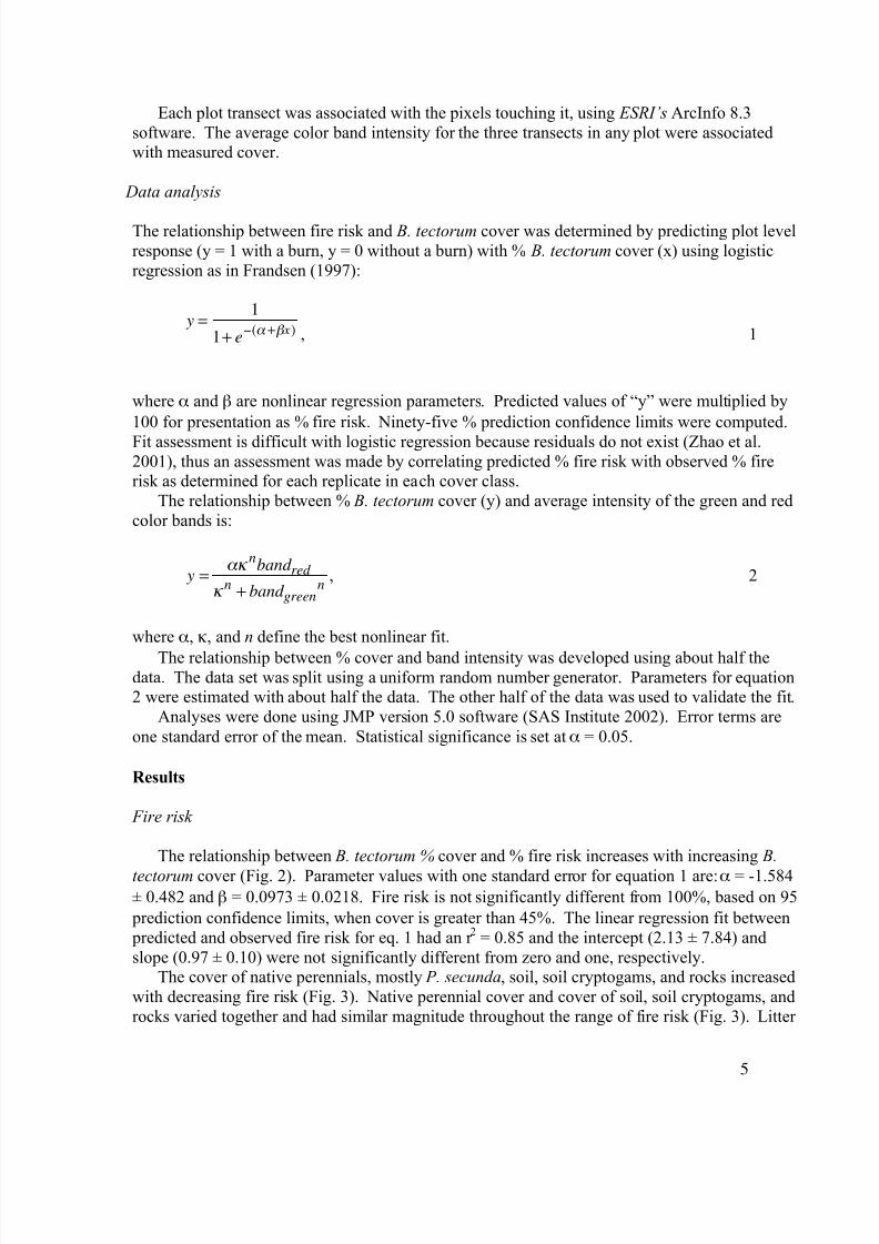
Data analysis
The relationship between fire risk and B. tectorum cover was determined by predicting plot levelresponse (y = 1 with a burn, y = 0 without a burn) with % B. tectorum cover (x) using logisticregression as in Frandsen (1997):
y =1
1+ e"(# +$ x) , 1
where ! and " are nonlinear regression parameters. Predicted values of “y” were multiplied by
100 for presentation as % fire risk. Ninety-five % prediction confidence limits were computed.
Fit assessment is difficult with logistic regression because residuals do not exist (Zhao et al.2001), thus an assessment was made by correlating predicted % fire risk with observed % firerisk as determined for each replicate in each cover class.
The relationship between % B. tectorum cover (y) and average intensity of the green and redcolor bands is:
y ="#
nband red
# n+ band green
n, 2
where !, #, and n define the best nonlinear fit.
The relationship between % cover and band intensity was developed using about half thedata. The data set was split using a uniform random number generator. Parameters for equation2 were estimated with about half the data. The other half of the data was used to validate the fit.
Analyses were done using JMP version 5.0 software (SAS Institute 2002). Error terms areone standard error of the mean. Statistical significance is set at ! = 0.05.
Results
Fire risk
The relationship between B. tectorum % cover and % fire risk increases with increasing B.
tectorum cover (Fig. 2). Parameter values with one standard error for equation 1 are: ! = -1.584± 0.482 and " = 0.0973 ± 0.0218. Fire risk is not significantly different from 100%, based on 95
prediction confidence limits, when cover is greater than 45%. The linear regression fit between predicted and observed fire risk for eq. 1 had an r 2 = 0.85 and the intercept (2.13 ± 7.84) andslope (0.97 ± 0.10) were not significantly different from zero and one, respectively.
The cover of native perennials, mostly P. secunda, soil, soil cryptogams, and rocks increasedwith decreasing fire risk (Fig. 3). Native perennial cover and cover of soil, soil cryptogams, androcks varied together and had similar magnitude throughout the range of fire risk (Fig. 3). Litter

7/18/2019 2013 Link et al Bromus Tectorum cover mapping and fire risk.pdf
http://slidepdf.com/reader/full/2013-link-et-al-bromus-tectorum-cover-mapping-and-fire-riskpdf 6/14
6
cover increases with increasing fire risk, but only from 26% to 36% across the range of fire risk (Fig. 3).
Remote sensing
Reflectance’s of the three-color bands are highly correlated (Table 1) and all showed a negativecorrelation between reflectance intensity and B. tectorum cover. The green band in eq. 2explained most variation. The inclusion of the red band in eq. 2 explained only a small amountof variation, but improved the fit. The blue band did not contain any new information outsidethat of the green and red bands and was not used.
Fig. 2. Relationship between the fire risk and B. tectorum cover. Observed values are classmeans for fire risk and cover. Error bars are one standard error of the mean (n = 4). The predicted line is based on equation 1. Confidence limits are 95% prediction estimates.
0
10
20
30
40
50
60
70
80
90
100
F i r e r i s k ( %
)
0 10 20 30 40 50 60 70 80
Bromus tectorum cover (%)
Confidence limts
Predicted
Observed

7/18/2019 2013 Link et al Bromus Tectorum cover mapping and fire risk.pdf
http://slidepdf.com/reader/full/2013-link-et-al-bromus-tectorum-cover-mapping-and-fire-riskpdf 7/14
7
Fig. 3. Mean fire risk as a function of mean cover of major surface categories other than B.tectorum (Fig. 2). Bars are one standard error of mean cover (n = 4). Standard error of mean firerisk is given in figure 2.
Table 1. Correlation between measured reflectance of the three color bands for 226
samples across the range of B. tectorum cover values.
Color bands Blue Green Red
Blue 1 0.971 0.930
Green 1 0.951Red 1
The relationships between B. tectorum cover and the intensity of the green (Fig. 4) and red bands (Fig. 5) decrease with increasing intensity.
40
50
60
70
80
90
100
M e a n f i r e r i s k
( % )
0 10 20 30 40
Mean cover (%)
Litter
Soil, cryptogams, rocks
Native perennials

7/18/2019 2013 Link et al Bromus Tectorum cover mapping and fire risk.pdf
http://slidepdf.com/reader/full/2013-link-et-al-bromus-tectorum-cover-mapping-and-fire-riskpdf 8/14
8
Fig. 4. Relationship (eq. 2) between cover
and intensity of the green color band.
Fig. 5. Relationship (eq. 2) between cover
and intensity of the red color band.
The predicted values of eq. 2 in figures 4 and 5 are based on the parameter values: ! = 0.730
± 0.0774, # = 95.0 ± 4.87, and n = 5.56 ± 0.905. These parameter values were estimated using
about half the data (n = 117). The linear regression between observed and predicted values for the estimation data set (data not shown) had an r 2 = 0.66. The data in figs. 4 and 5 are the other half of the data (n = 109) set used for validation. The linear regression between observed and predicted values for the validation data set had an r 2 = 0.59. The intercept (2.02 ± 2.84) andslope (0.94 ± 0.08) were not significantly different from zero and one respectively, thus the prediction model is substantiated in this experiment.
Predicted B. tectorum cover shows fine scale patterns across the landscape (Fig. 6). Areas tothe west have less B. tectorum cover than areas to the east. In the mapped area, there are 16.8 hawith B. tectorum cover less than 20%, 48.3 ha with cover between 20 and 40%, and 88.3 hawhere B. tectorum cover is greater than 40%.
Predicted fire risk (eq. 1) patterns are similar to those of B. tectorum cover across thelandscape (Fig. 6). In areas with less than 20% B. tectorum cover, the risk of fire is less than60%. When B. tectorum cover is between 20 and 40% the risk of fire is between 60 and 86%.When B. tectorum cover is greater than 40%, the risk of fire is greater than 86% (Fig. 2). Roadscan be recognized having low B. tectorum cover and fire risk (Fig. 6)

7/18/2019 2013 Link et al Bromus Tectorum cover mapping and fire risk.pdf
http://slidepdf.com/reader/full/2013-link-et-al-bromus-tectorum-cover-mapping-and-fire-riskpdf 9/14
9
Fig. 6. Aerial photography map of B. tectorum % cover based on eq. 2 and % fire risk based oneq. 1. These maps encompass the study areas in figure 1.

7/18/2019 2013 Link et al Bromus Tectorum cover mapping and fire risk.pdf
http://slidepdf.com/reader/full/2013-link-et-al-bromus-tectorum-cover-mapping-and-fire-riskpdf 10/14
10
Discussion
We experimentally determined the relationship between the risk of sustained fire and cover of B.
tectorum. Fire risk can now be mapped because we were able to relate B. tectorum cover toaerial photographic color band reflectance. This approach will allow land managers to determinethe costs of fuel reduction as a function of fire risk in semi-arid western regions of NorthAmerica. Our results are relevant to the conditions of the test. They are relevant to A. tridentata – P. secunda associations where A. tridentata has been lost, where B. tectorum is a significantcomponent, and to fall fire conditions.
Fire risk
There was a logistic relationship between B. tectorum cover and the risk of fire. Fuel continuityincreases with increasing cover causing the risk of a sustainable fire to increase. When B.
tectorum cover is greater than 45%, fuel adjacent to the point of ignition is always, under theexperimental conditions, close enough to carry the fire. The risk of fire dropped to 46% when B.
tectorum cover was 12%. Under these circumstances, soil, soil cryptogams and rock cover wasabout 31% substantially reducing the risk of ignition and fire. The fuel cover provided by P.
secunda, which comprised most of the cover of native perennials is also less. Because thesesmall bunchgrasses often have no fuel between them, the likelihood that fire will carry, is less.Fire does carry when litter and dead attached leaves of the bunchgrasses are close. These firesleft some patchy unburned fuel, and thus were likely less intense than those with high B.
tectorum cover.Fire risk estimates have been determined using the logistic regression approach in forest
(Cruz et al. 2003; Lawson et al. 1994) and perennial grassland (Clark 1983; Marsden-Smedley etal. 1999) ecosystems. These estimates were made in measured, but uncontrolled conditionswhere fuel load is a significant, but not strong predictor, along with wind and moisture levels.Our estimates were taken in an ecosystem where the invasive annual grass, B. tectorum, isrecognized as a strong causal factor in fire occurrence (Whisenant 1990). Although we did notexamine the effects of wind speed and fuel moisture on fire risk, the relationship between %cover and fire risk was strong. Our fire risk estimates at low (about 46% fire risk) and high(100% fire risk) B. tectorum cover are comparable to those of Hayden et al. (2000) who foundfire risk increased from 52% in young grasslands with low biomass to 83% in old stands withmore biomass. It is likely that fire risk would increase with increasing wind speed and decreasewith increasing fuel moisture content.
Remote sensing
The correlations between color band reflectance intensity and cover of senescent B. tectorum
were negative for all color bands. A similar finding was observed by Pickup et al. (1993) usingLandsat MSS data in arid Australia. Negative correlations were found for both dry and greenvegetation when correlated with MSS bands 4 (0.4 – 0.6 µm) and 5 (0.6 – 0.7 µm). In our study,
the highest intensity of reflectance always occurred when B. tectorum cover was the lowest.Under these circumstances, soil and perennials plants, primarily P. secunda, reflect more in our

7/18/2019 2013 Link et al Bromus Tectorum cover mapping and fire risk.pdf
http://slidepdf.com/reader/full/2013-link-et-al-bromus-tectorum-cover-mapping-and-fire-riskpdf 11/14
11
three color bands than does the light brown to blond color of senescent B. tectorum andassociated litter. Bright colors of soil and low reflectance of litter in rangeland ecosystems arerecognized (Pickup et al. 1993) and our results confirm this using aerial photography.
The applicability of our results to other ecosystems dominated by B. tectorum likely isaffected by soil type. Correlation between vegetative cover and reflectance depends on soil type
(Pickup et al. 1993), thus our results may only be applicable to landscapes with the same or similar soil type.The scale of aerial photography allows for fine resolution of B. tectorum cover in space. Fine
(0.3 m) scale spatial resolution could be useful for detecting the amount of B. tectorum cover along surfaces such as roads as in figure 6 compared with the coarser (30 m) scale imagery suchas Landsat TM that could be strongly influenced by the road.
Bromus tectorum cover values were highly variable at any level of reflectance (Figs. 4 and5). It is likely that some variation can be attributed to error in associating pixels with groundlocations given the GPS unit was at best, only accurate to 0.3 m. The range of cover values waslower when cover was high (Figs. 4 and 5) which suggests that location errors are less significantwhen similar cover exists in a large area. A more accurate GPS unit, perhaps survey grade,
likely would result in less variation in cover across the range of reflectance values.We found significant relationships between the cover of senescent B. tectorum and color band reflectance that allows mapping of B. tectorum cover and fire risk. Bradley et al. (2003)were able to map B. tectorum cover in northern Nevada at Landsat scale (30 m) by computingthe ratio of NDVI in a high rainfall year to NDVI in a low rainfall year. This approach dependson the high sensitivity of B. tectorum to precipitation compared to perennial vegetation. Thisapproach is limited because areas experiencing different amounts of precipitation, compared withthe local area used to create the ratio, will be biased with potential for misclassification.Peterson (2003) used variation in phenological progression to separate B. tectorum from other perennial bunchgrasses by taking pictures in spring and summer. This approach could lead tomisclassification because the phenology of B. tectorum and P. secunda are similar and because phenology on north facing slopes is different than that on south facing slopes. Using NDVI toseparate B. tectorum from other perennial grasses may fail if there is little difference betweengreen and brown vegetation NDVI signatures. Kremer and Running (1993) were unable toobserve a difference between B. tectorum and bunchgrass communities using AVHRR NDVIsignals anytime during the year. They indicate that the amount of senescent vegetation and baresoil can significantly influence NDVI signatures and that the these effects can overwhelm color differences in the shrub-steppe. Our approach, based on reflectance of standing dead inSeptember, reduces or eliminates potential classification errors associated with differences in phenology. It is likely that accurate prediction across landscapes will require relating variationin cover and reflectance on differing slopes, aspects, and soil types within any plant associationwhere B. tectorum can be dominant.
Management implications
The reduction of fire risk associated with B. tectorum in the western United States is amanageable activity. Budgeting is possible based on experience with this invasive alien plantand experience with establishing fire resistant species in the west. It has been estimated thatthere are at least 40 million hectares affected by B. tectorum and associated fires (D'Antonio andVitousek 1992; Whisenant 1990). If it cost about $740 ha-1 (estimate for herbicide, seed, and

7/18/2019 2013 Link et al Bromus Tectorum cover mapping and fire risk.pdf
http://slidepdf.com/reader/full/2013-link-et-al-bromus-tectorum-cover-mapping-and-fire-riskpdf 12/14
12
drill seeding) to reduce fire risk to levels found in ecosystems dominated by fire resistant native perennial bunchgrass species that can control B. tectorum, then it could cost about $30 billion. If this effort were spread over ten years then the cost is only about $3 to 4 billion year -1withinflation. The amount of land in need of control may be less and can be determined using theresults of this research. The cost of aerial photography and processing for the Columbia National
Wildlife Refuge has been estimated to be about $20,000 for about 9,300 ha or about $2.15 ha
-1
.Further refinement of the amount of land that needs control will reduce the overall price. Theseexpenses may be viewed as justifiable given the costs these fires and B. tectorum cause societyassociated with property loss, rangeland degradation, and other habitat quality losses.
Conclusions
The relationship between the risk of sustained fire and cover of B. tectorum has beenexperimentally determined in the field. When B. tectorum cover is greater than 45%, fire risk is100%. Minimal fire risk is 46% when B. tectorum cover is about 12% and native perennials plus
soil and soil cryptogam cover are each about 30%. It is possible to relate B. tectorum cover tocolor band reflectance of aerial photographs, thus it is now possible to map B. tectorum cover across landscapes. Because the relation between B. tectorum cover and fire risk can bedetermined, fire risk can now be mapped. The methods used in this study can be applied in other landscapes to map B. tectorum cover and associated fire risk. This approach will allow landmanagers to determine the costs of fuel reduction as a function of fire risk in semi-arid westernregions of North America.
Acknowledgements
We thank Dr. Robert Clark for suggestions that improved the experiment. We thank Susan Nelson and anonymous reviewers for suggestions that improved the manuscript. Dr. Marita Lih,August Plechta, Louis Boddy, Momcilo Bozic, Miljan Ignactic, Elhaum Vancil, Anna Reardon,Josh Reardon, Aaron Bibe, JJ Coats, Christy Fiander, Scott Immele, Jenny Meisel, Dave Smith,Tom Padgett, David McDonald, Genna Gaston, Heidi Newsome, Jerry Vineyard, and SandyHalstead assisted in the field. Eric Kelchlin assisted with the global positioning system and datainterpretation. Vern Potts, Washington State Department of Transportation took the aerial photos. Photos were orthorectified by Michael Vachon, Yakima County. The Joint Fire ScienceProgram supported this work.
References
Bond, W. J., and B. W. v. Wilgen. 1996. Fire and Plants. Chapman and Hall, London.Bonham, C. D. 1989. Measurements for Terrestrial Vegetation. John Wiley & Sons, New York.Bradley, B. B., J. F. Mustard, and J. Albert. 2003. How big is the problem? Constraints on the
extent of cheatgrass invasion in the Great Basin, US. Eos. Trans. AGU, 84(46), Fall Meet.Suppl., Abstract B31A-07
Clark, R. G. 1983. Threshold requirements for fire spread in grassland fuels. Texas TechUniversity, Lubbock, Dissertation.

7/18/2019 2013 Link et al Bromus Tectorum cover mapping and fire risk.pdf
http://slidepdf.com/reader/full/2013-link-et-al-bromus-tectorum-cover-mapping-and-fire-riskpdf 13/14
13
Cruz, M. G., M. E. Alexander, and R. H. Wakimoto. 2003. Assessing the probability of crownfire initiation based on fire danger indices. The Forestry Chronicle 79:976-983.
D'Antonio, C. M., and P. M. Vitousek. 1992. Biological invasions by exotic grasses, thegrass/fire cycle, and global change. Annu. Rev. Ecol. Syst 23:63-87.
Daubenmire, R. 1970. Steppe vegetation of Washington, Pullman, Washington.
Elmore, A. J., J. F. Mustard, and S. J. Manning. 2003. Regional patterns of plant communityresponse to changes in water: Owens Valley, California. Ecological Applications 13:443-460.
Frandsen, W. H. 1997. Ignition probability of organic soils. Canadian Journal of Forest Research27:1471-1477.
Hayden, D. T., J. K. Friar, and E. R. Pianka. 2000. Fire-driven dynamic mosaics in the GreatVictoria Desert, Australia. I. Fire geometry. Landscape Ecology 15:373-381.
Hitchcock, C. L., and A. Cronquist. 1976. Flora of the Pacific Northwest. University of Washington Press, Seattle.
Knapp, P. A. 1998. Spatio-temporal patterns of large grassland fires in the Intermountain West,U.S.A. Global Ecology and Biogeography Letters 7:259-272.
Knick, S. T., and J. T. Rotenberry. 1997. Landscape characteristics of disturbed shrubsteppehabitats in southwestern Idaho (U.S.A.). Landscape Ecology 12:287-297.Kremer, R. G., and S. W. Running. 1993. Community type differentiation using NOAA/AVHRR
data within a sagebrush-steppe ecosystem. Remote Sensing of the Environment 46:311-318.Lawson, B. D., O. B. Armitage, and G. N. Dalrymple. 1994. Ignition probabilities for simulated
people-caused fires in B.C.'s lodgepole pine and white spruce-subalpine fir forests.Proceedings of the 12th Conference on Fire and Forest Meteorology, SAF Publ. 94-02:493-505.
Link, S. O., G. W. Gee, and J. L. Downs. 1990. The effect of water stress on phenological andecophysiological characteristics of cheatgrass and Sandbergs's bluegrass. Journal of RangeManagement 43:506-513.
Link, S. O., J. L. Smith, J. J. Halvorson, and J. H. Bolton. 2003. Effect of climate change on a perennial bunchgrass and soil carbon and nitrogen pools in a semi-arid shrub-steppeecosystem. Global Change Biology 9:1097-1105.
Mack, R. N. 1981. Invasion of Bromus tectorum L. into western North America: an ecologicalchronical. Agro-Ecosystems 7:154-165.
Marsden-Smedley, J. B., T. Rudman, A. Pyrke, and W. R. Catchpole. 1999. Buttongrassmoorland fire-behaviour prediction and management. Tasforests 11:87-107.
Menakis, J. P., D. Osborne, and M. Miller. 2003. Mapping the cheatgrass-caused departure fromhistorical natural fire regimes in the Great Basin, USA. Proceedings,
Monsen, S. B. 1994. The competitive influences of cheatgrass ( Bromus tectorum) on siterestoration. Proceedings - ecology and management of annual rangelands,
Nagler, P. L., E. P. Glenn, and A. R. Huete. 2001. Assessment of spectral vegetation indices for riparian vegetation in the Colorado River delta, Mexico. Journal of Arid Environments49:91-110.
Pellant, M. 2002. Cheatgrass: Invasion, Occurrence, biological/competitive features and controlmeasures. Restoration and Management of Sagebrush/Grass Communities Workshop, Elko, NV 29-33.
Peterson, E. B. 2003. Mapping percent-cover of the invasive species Bromus tectorum(cheatgrass) over a large portion of Nevada from satellite imagery. For the U. S. Fish and

7/18/2019 2013 Link et al Bromus Tectorum cover mapping and fire risk.pdf
http://slidepdf.com/reader/full/2013-link-et-al-bromus-tectorum-cover-mapping-and-fire-riskpdf 14/14
14
Wildlife Service, Nevada State Office, Reno, by the Nevada Natural Heritage Program,Carson City.
Pickup, G., V. H. Chewings, and D. J. Nelson. 1993. Estimating changes in vegetation cover over time in arid rangelands using Landsat MSS data. Remote Sensing of the Environment43:243-263.
SAS Institute. 2002. JMP Statistics and Graphics Guide, Version 5. SAS Institute Inc, Cary.Thorp, J. M., and W. T. Hinds. 1977. Microclimates of the Arid Lands Ecology Reserve, 1968-1975. Pp. 100. Battelle Pacific Northwest Laboratories BNWL-SA-6231, Richland,Washington.
Tucker, C. J. 1978. Post senescent grass canopy remote sensing. Remote Sensing of theEnvironment 7:203-210.
Whisenant, S. G. 1990. Changing fire frequencies on Idaho's Snake River plains: ecological andmanagement implication. USDA Forest Service Intermountain Research Station GeneralTechnical Report: INT-276:4-10
Zhao, L., Y. Chen, and D. W. Schaffner. 2001. Comparison of logistic regression and linear regression in modeling percentage data. Applied and Environmental Microbiology 67:2129-
2135.