2011 wood river wetland yellow rail (coturnicops ... · 2011 wood river wetland yellow rail...
TRANSCRIPT
2011 Wood River Wetland Yellow Rail (Coturnicops neveboracensis
noveboracensis) Survey Report
Project Description
The Bureau of Land Management’s Wood River Wetland is located in T34S-R 7 1/2E; the wetland
borders Agency Lake to the south, seven-mile canal to the west, the Wood River to the east and is
bordered by private to the north (Fig 1). Restoration to improve water quality and habitat back to
original conditions on approximately 3,000 acres of historically used cattle grazing land within the
wetland has been ongoing since 1996 (Popper 2001). Dominant tree species are cottonwood, willows,
and aspen. Among the many sedges and grasses the wetland plants consist primarily of Hardstem
Bulrush (Tule), Common Cattail, Wocus, and big leaf lupine.
Yellow rails are a Bureau of Land Management (BLM) sensitive species due to loss of wetland habitat
and are being monitored in the Wood River Wetland by the BLM. Yellow rails area small marshbird and
are characterized by a dark crown and eye stripe, a short tail, and a yellow chest and face. Rails are a
thin bird that allows them to move about quickly in dense marsh vegetation. Their distinct clicking calls
are heard exclusively at night, this, along with their secretive nature, can make gathering information on
them difficult.
Yellow rail surveys were conducted from May through July 2011, according to the 2006 yellow rail
protocol written by Kenneth J. Popper of The Nature Conservancy. The goal of the survey was to
determine whether or not yellow rails are utilizing habitat within the BLM Wood River Wetland and
surrounding private lands.
Historic Activity
Inventories done between 1982 and 1992 by the Oregon Natural Heritage Program (ORNHIC) and The
Nature Conservancy (TNC) provided information on yellow rails in Oregon (Popper 2006). Due to limited
information on yellow rails, in 1988 ORNHIC and TNC began doing surveys in the Wood River Valley and
surrounding areas (Popper 2006).
The Wood River Wetland was previously surveyed for yellow rails in 1999, 2000, 2003, and 2004.
Previous reports from these surveys demonstrate that yellow rails have been heard within the Wood
River Wetland (Table 1) but due to the lack of systematic surveys, information is limited. The 2004
report indicated that a dead yellow rail was found within the wetland, signifying that yellow rails use this
area if they have a few inches of standing water. Total yellow rails heard throughout previous surveyed
years are 17 birds.
1
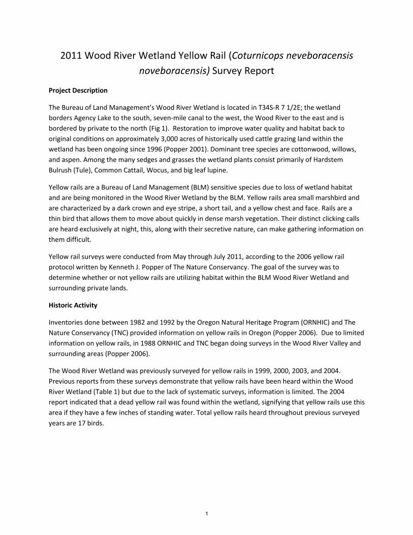
Category 1996 1997 1998 1999 2000 2001 2002 2003 2004 Totals
Males heard calling at Wood River Wetland
0 0 6 6 3 0 1 0 0 16
*One Male found dead 2004
1 1
Total 17 Table 1. Results of Yellow Rail surveys at Wood River Wetland.
Survey Methods
Kenneth Popper was contacted by telephone to provide clarification on survey protocol and any
additional questions concerning yellow rails. Communication was maintained through e-mail for any
additional questions.
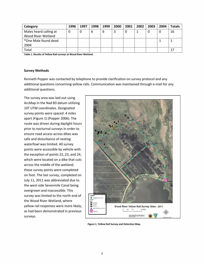
The survey area was laid out using
ArcMap in the Nad 83 datum utilizing
10T UTM coordinates. Designated
survey points were spaced .4 miles
apart (Figure 1) (Popper 2006). The
route was driven during daylight hours
prior to nocturnal surveys in order to
ensure road access across dikes was
safe and disturbance of nesting
waterfowl was limited. All survey
points were accessible by vehicle with
the exception of points 22, 23, and 24,
which were located on a dike that cuts
across the middle of the wetland;
these survey points were completed
on foot. The last survey, completed on
July 11, 2011 was abbreviated due to
the west-side Sevenmile Canal being
overgrown and inaccessible. This
survey was limited to the north end of
the Wood River Wetland, where
yellow rail responses were more likely,
as had been demonstrated in previous
surveys.
Figure 1. Yellow Rail Survey and Detection Map.
2
Surveys began around 2140 and were considered complete once all points were called. Surveys were
spaced approximately 11-15 days apart as recommended by 2006 protocol. An MP3 player was used to
produce yellow rail vocalizations. Using the 2006 yellow rail protocol, five minutes were spent at each
survey point, in order to both hear and broadcast the call. The MP3 player was played orienting in two
opposite directions. When a bird was detected, a compass bearing was taken. Surveys were not
conducted in windy or rainy conditions. Other bird species detected were noted, and upon each night
survey, completion of a one paragraph summary was written. Water depth was measured within the
BLM wetland by the hydrology crew on corresponding survey days. The measurements were taken off
the North Staff plate. These measurements do not measure the water levels on private lands
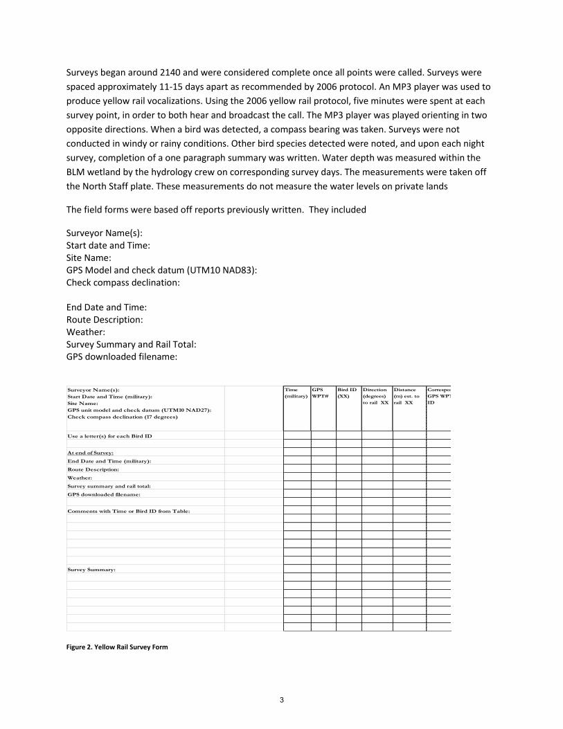
The field forms were based off reports previously written. They included
Surveyor Name(s): Start date and Time: Site Name: GPS Model and check datum (UTM10 NAD83): Check compass declination: End Date and Time: Route Description: Weather: Survey Summary and Rail Total: GPS downloaded filename:
Figure 2. Yellow Rail Survey Form
Surveyor Name(s):
Start Date and Time (military):
Site Name:
GPS unit model and check datum (UTM10 NAD27):
Check compass declination (17 degrees)
Time
(military)
GPS
WPT#
Bird ID
(XX)
Direction
(degrees)
to rail XX
Distance
(m) est. to
rail XX
Corresponding
GPS WPT and Bird
ID
Use a letter(s) for each Bird ID
At end of Survey:
End Date and Time (military):
Route Description:
Weather:
Survey summary and rail total:
GPS downloaded filename:
Comments with Time or Bird ID from Table:
Survey Summary:
3
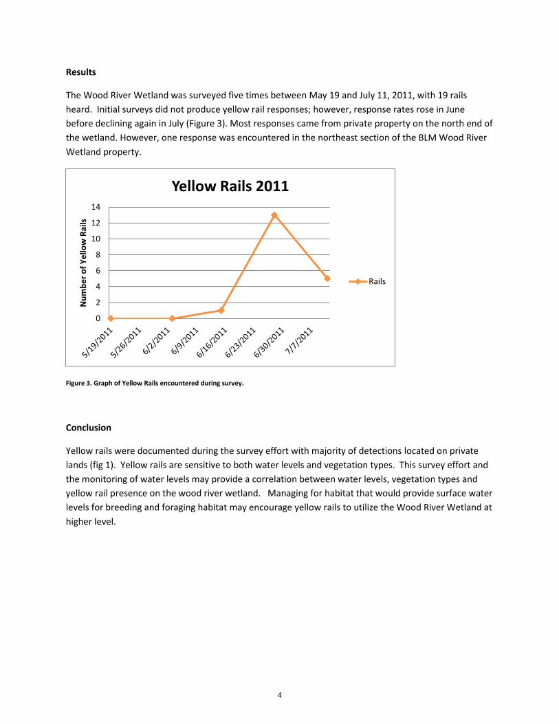
Results
The Wood River Wetland was surveyed five times between May 19 and July 11, 2011, with 19 rails
heard. Initial surveys did not produce yellow rail responses; however, response rates rose in June
before declining again in July (Figure 3). Most responses came from private property on the north end of
the wetland. However, one response was encountered in the northeast section of the BLM Wood River
Wetland property.
Figure 3. Graph of Yellow Rails encountered during survey.
Conclusion
Yellow rails were documented during the survey effort with majority of detections located on private
lands (fig 1). Yellow rails are sensitive to both water levels and vegetation types. This survey effort and
the monitoring of water levels may provide a correlation between water levels, vegetation types and
yellow rail presence on the wood river wetland. Managing for habitat that would provide surface water
levels for breeding and foraging habitat may encourage yellow rails to utilize the Wood River Wetland at
higher level.
0
2
4
6
8
10
12
14
Nu
mb
er
of
Ye
llow
Rai
ls
Yellow Rails 2011
Rails
4
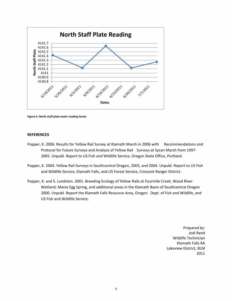
Figure 4. North staff plate water reading levels.
REFERENCES
Popper, K. 2006. Results for Yellow Rail Survey at Klamath Marsh in 2006 with Recommendations and
Protocol for Future Surveys and Analysis of Yellow Rail Surveys at Sycan Marsh from 1997-
2005. Unpubl. Report to US Fish and Wildlife Service, Oregon State Office, Portland.
Popper, K. 2004. Yellow Rail Surveys in Southcentral Oregon, 2003, and 2004. Unpubl. Report to US Fish
and Wildlife Service, Klamath Falls, and US Forest Service, Crescent Ranger District.
Popper, K. and S. Lundsten. 2001. Breeding Ecology of Yellow Rails at Fourmile Creek, Wood River
Wetland, Mares Egg Spring, and additional areas in the Klamath Basin of Southcentral Oregon
2000. Unpubl. Report the Klamath Falls Resource Area, Oregon Dept. of Fish and Wildlife, and
US Fish and Wildlife Service.
Prepared by: Jodi Reed
Wildlife Technician Klamath Falls RA
Lakeview District, BLM 2011
4140.84140.9
41414141.14141.24141.34141.44141.54141.64141.7
No
rth
Sta
ff P
late
Dates
North Staff Plate Reading
5