2011-2012 michigan winter hazards awareness more information visit november 2011 2011-2012 michigan...
TRANSCRIPT

For more information visit www.mcswa.com November 2011
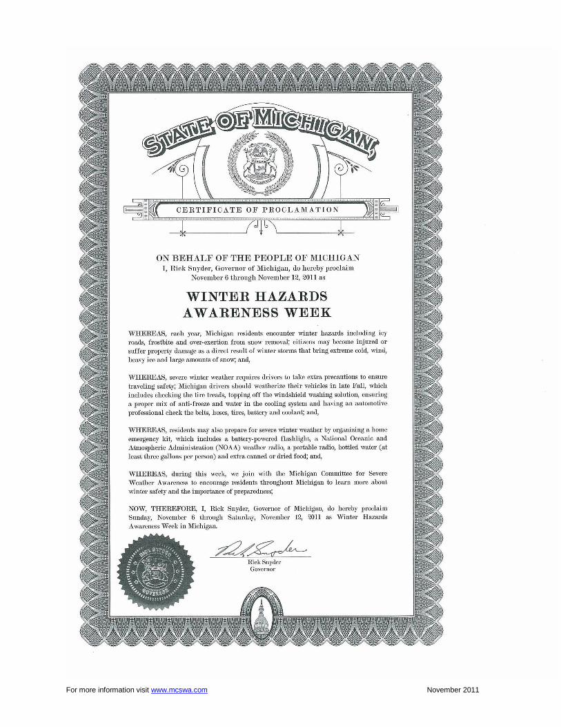
2011-2012 Michigan Winter Hazards Awareness
INSIDE THIS PACKET Governor’s Proclamation
Committee for Severe Weather Awareness Contacts
2009-2010 Winter Season Review
Winter Safety Tips
Winter Hazards Frequently Asked Questions (FAQs)
Preventing Frozen Pipes
Preventing Roof Ice Dams
Ice Jams/Flooding
Preventing Flood Damage
Flood Insurance FAQs
Winter Power Outage Tips -
Heat Sources Safety
Portable Generator Hazards
National Weather Service Offices
The Michigan Committee for Severe Weather Awareness was formed in 1991 to promote safety awareness and coordinate public information efforts regarding tornadoes, lightning, flooding and winter weather.
For more information visit www.mcswa.com November 2011
For more information visit www.mcswa.com November 2011
Michigan Committee for Severe Weather Awareness
Rich Pollman, Chair National Weather Service 9200 White Lake Road White Lake, MI 48386-1126 248/625-3309, Ext. 726 [email protected] Mary Stikeleather-Piorunek, Vice Chair Lapeer County Emergency Management 2332 W. Genesee Street Lapeer, MI 48446 810/667-0242 [email protected] Lori Conarton, Secretary Insurance Institute of Michigan 334 Townsend Lansing, MI 48933 517/371-2880 [email protected] Mark Walton National Weather Service 4899 South Complex Drive, S.E. Grand Rapids, MI 49512 616/949-0643, Ext. 493 [email protected] Paul Gross Meteorologist, WDIV-TV 550 W. Lafayette Detroit, MI 48226-3140 313/222-0444, Ext. 318 [email protected] David Chapman MI Earth Science Teachers Association Okemos High School 2800 Jolly Road Okemos, MI 48864 517/706-4886 [email protected]
Kevin Thomason State Farm Insurance P.O. Box 4094 Kalamazoo, MI 49003-4094 269/384-2580 [email protected] Terry Jungel Michigan Sheriffs’ Association 515 N. Capitol Lansing, MI 48933 517-485-3135 [email protected] Les Thomas Michigan Dept. of Environmental Quality P.O. Box 30458 525 W. Allegan Lansing, MI 48909-7958 517/335-3448 [email protected] Terry DeDoes Consumers Energy 530 W. Willow Lansing, MI 48909-7662 517/374-2159 [email protected] Mary Wichman Michigan Department of State Police Emergency Management & Homeland Security 4000 Collins Rd Lansing, MI 48910 517/333-5023 [email protected]
For more information visit www.mcswa.com November 2011
Michigan Committee for Severe Weather Awareness
2010-2011 Winter Season Review
According to the National Weather Service, Michigan’s southern Lower Peninsula winter was colder
and snowier than normal, while areas across the Upper Peninsula and far Northern Lower had more average
temperatures with below average snowfall. The storm track through much of the winter went through the Ohio
Valley, typical of a La Nina winter. This storm track put Southern Lower Michigan in the swath of the heavy
snow and strong winds for many of those storms. The end result was above normal snowfall with many
locations in Southeast and extreme Southern Lower in their top ten snowiest winters on record including the
fifth snowiest winter on record for Detroit and Saginaw.
The winter started slowly across the state. It wasn’t until the Thanksgiving holiday weekend that the
first widespread snows fell across the state. A powerful fall storm moved across the upper Mississippi River
Valley on October 25 to 27. This storm was a historically deep low pressure and set many records across the
upper Midwest for lowest pressure. The storm sent strong winds across the state with wind gusts in excess of
60 mph. Many trees and power lines were downed by the strong winds which left tens of thousands of
Michigan households without power.
Early December was the first significant winter weather for the state. The month started with a couple
of lake effect snow events across the usual lake effect regions of Upper and Western Lower Michigan. A few of
the higher snowfalls were in Sault Ste. Marie with 8.5 inches of snow from the December 2 lake effect event,
and east of Ludington with 24 inches from the December 5 – 7 lake effect event. By far the most significant
storm of the month was one that moved from Iowa across the Michigan-Indiana-Ohio border and into eastern
Ontario on December 11 – 12. This storm dropped 5 to 15 inches of snow north of Interstate 96 accompanied
by wind gusts of 25 to 40 mph which lead to near blizzard conditions. Arctic air blasted across the state at the
very end of the storm which created a ―flash freeze‖ on many of the roads. As the arctic air moved over the
Great Lakes, lake effect snow developed over Berrien County and the Thumb region. Blizzard conditions were
experienced in these locations with up to 20 inches of snow and drifts of 6 to 10 feet.
Very little significant winter activity was noted in January across the entire state as the storm track
across the United States missed Michigan. There were periods of very cold air and associated lighter snowfall
with the lake effect throughout the month. There was a one noteworthy lake effect event at the beginning of the
month from January 6 – 8. While every location in Michigan had 2 to 6 inches of snow from the long period of
lake effect snow many locations received much more: Port Austin in the Thumb had 8 inches; Berrien, Cass,
and Van Buren Counties had 1 to 2 feet; Bellaire had 24 inches; and Darragh had 20 inches.
The ―Groundhog Day‖ blizzard was the headline event of the winter, not only in Michigan but across
the county. This blizzard stretched from Oklahoma through Chicago and Michigan and into the New England
states. The storm produced widespread blizzard conditions from the Holland/Grand Rapids area northeast
through the Saginaw Bay region. Snowfall in this band across Central Lower Michigan ranged from 10 to 15
inches. The winds gusted in excess of 40 mph for hours which created whiteout conditions, snow drifts of 3 to
5 feet and made travel nearly impossible. Outside of that area of blizzard conditions, snow piled up to 6 to 12
inches with near blizzard conditions all the way south to the southern border and as far north as Manistee and
Alpena.
For more information visit www.mcswa.com November 2011
The other February storm hit Southern and Central Lower Michigan on February 20 – 21. This storm
was an ice storm along and south of a Kalamazoo to Monroe line. The ice accumulated up to a half inch with
some isolated locations with an inch of ice. This downed thousands of trees and power lines throughout that
region. Many people were without power for 4 to 5 days. In all, up to 10 million dollars in damages were
caused by the ice storm. Farther north, heavy snow fell with 5 - 10 inches of snow along and south of a
Manistee to Tawas line.
The winter season ended with bouts of light snow in March and then again in April across the northern
portions of the state. There were two strong storms to end the winter season. On March 22 – 23, areas north
of a Baldwin to Port Huron line received 6 to 15 inches of snow from a storm that moved through the center
part of the Great Lakes region. This storm dumped heavy snow as far north as the southern part of the Upper
Peninsula. The last storm hit on April 19 -20 with a narrow band of heavy snow around Traverse City to
Alpena. The 5 – 10 inches of April snow resulted in tree damage in some areas, due to some trees
already having their spring foliage.

For more information visit www.mcswa.com November 2011
PREPARING FOR A WINTER STORM
At home:
Keep handy a battery-powered flashlight, National Oceanic and Atmospheric Administration (NOAA) weather radio and portable radio, extra food (canned or dried food is best), can opener, and bottled water (at least 3 gallons per person).
Make sure each member of the household has a warm coat, gloves, hat and water-resistant boots. Ensure extra blankets and heavy clothes are available.
Keep on hand items for infant, elderly or disabled family members.
Keep on hand items for your pets. Animals feel the effects of wind chill. Be sure to have suitable shelter with food and water.
Be aware of potential fire and carbon monoxide hazards if you plan to use an emergency heating source such as a fireplace, wood stove or space heater. (See Heat Sources Safety page later in this packet for more information.)
Outside:
Avoid overexertion, such as shoveling heavy snow, pushing a car, or walking in deep snow. Sweating could lead to chill and hypothermia, an abnormally low body temperature. Cold weather also puts extra strain on the heart, so the elderly and those with heart conditions should be especially cautious when out in the cold.
Walk carefully on snowy, icy sidewalks.
Wear loose-fitting, lightweight warm clothing in layers, with a waterproof outer layer. Wear a wool hat and mittens.
Keep your clothes dry. Change wet socks and clothing quickly to prevent loss of body heat.
Understand the hazards of wind chill. As wind speed increases, heat is carried away from a person’s body more rapidly which could lead to severe hypothermia.
Automotive preparedness:
Be sure the vehicle is winterized by late fall. This includes having the proper mix of antifreeze and water in the cooling system, topping off the windshield washing solution, and checking the tire treads. Have a mechanic check the belts, hoses, tires, battery, and coolant.
Keep the fuel tank near full, as low fuel levels can cause condensation to form, degrading fuel quality and possibly causing the fuel line to freeze. Additionally, gas stations may be closed during a severe winter storm, so it is wise to fill up if storm warnings are being broadcasted.
Your car should always be equipped with emergency supplies. Keep the following items stored in a portable container: A small battery powered radio (AM is sufficient) and extra batteries Flashlight with extra batteries Cellular phone Windshield scraper Jumper cables Fire extinguisher Maps Shovel Blanket and extra clothes Flares Bottled water and nonperishable, high energy foods (granola bars, canned nuts, raisins, hard candy,
trail mix, peanut butter and crackers) First aid kit Tire repair kit and pump Tow chain or rope Phone book and phone list De-icer and extra antifreeze ―Call Police‖ or other ―Help‖ sign

For more information visit www.mcswa.com November 2011
DURING A WINTER STORM
At home:
To save heat, close off unneeded rooms, cover windows at night and stuff towels or rags in cracks under doors.
Maintain adequate food and water intake. Food provides the body with energy for producing its own heat.
If travel is necessary:
Use caution when driving in winter conditions. The highest rate of traffic crashes due to winter weather is in the month of November when the snow first starts to fall over Michigan.
Inform someone of your destination and travel time. Bring a cell phone in case you must call for help.
If traveling and the power goes out:
Use extreme caution when driving. If traffic signals are out, treat each signal as a stop sign – come to a complete stop at every intersection and look for oncoming traffic before proceeding.
Do not call 9-1-1 to ask about the power outage. Listen to news radio stations for updates and contact your electrical company.
If stranded in a vehicle:
DO NOT leave your vehicle.
DO NOT park under an overpass or bridge as this can trap deadly carbon monoxide fumes.
Attach a bright cloth to your antenna to attract attention.
Run the motor about 10 minutes each hour for heat. Open the window slightly for fresh air and make sure the exhaust pipe is not blocked.
Attract attention by turning on the dome light and emergency flashers when running the engine.
To keep blood circulating and to stay warm, exercise by moving arms, legs, fingers and toes. If stranded outside:
Try to stay dry and cover all exposed parts of the body.
Prepare a windbreak or snow cave for protection from the wind. Build a fire for heat and to attract attention.
Do not eat snow because it will lower your body temperature. Melt it first.
ANYTIME
Listen to an All-Hazards NOAA Weather Radio or local radio, television and cable stations for the latest updates on hazardous winter weather.
To ensure uninterrupted weather information, make sure the NOAA Weather Radio or other radio has a battery-operated backup and fresh batteries. A battery-operated TV is also another option.
For All-Hazards NOAA Weather Radio information, including a station near you, visit the NOAA Weather Radio web site at http://www.nws.noaa.gov/nwr or contact your National Weather Service office.
Know the difference between a winter storm WATCH (conditions make the storm possible) and winter storm WARNING (the storm is occurring or headed for your area).
A blizzard WARNING means strong winds, blinding wind-driven snow, and dangerous wind chill.
Avoid driving and seek shelter.
For more information visit www.mcswa.com November 2011
On average, a major winter storm hits some part of Michigan at least once per month between October and April. In 2008, the last year that statistics were available, 45 people died in Michigan as a direct result of severe winter weather according to the Michigan Department of Community Health. This is in addition to victims of traffic crashes due to slippery roads and those who suffered heart attacks while shoveling snow. 1. What is wind chill?
Wind chill is the perceived temperature resulting from the effect of wind, in combination with cold air, which increases the rate of heat loss from the human body. More information including the wind chill chart can be found at: http://www.nws.noaa.gov/os/windchill/index.shtml
2. What is frostbite and what can you do to treat it?
Frostbite is damage to body tissue caused by that tissue being frozen. Frostbite causes a loss of feeling and a white or pale appearance in extremities, such as fingers, toes, ear lobes, or the tip of the nose. Frostbite varies in severity from frostnip to deep frostbite, depending on the length of exposure, temperature to which the skin is exposed, and wind speed. For frostnip, place firm, steady pressure from a warm hand against the area. Also, blow on the surface holding the frostnipped area against the body. Do not rub the area, apply snow, or plunge it into very hot or cold water. Victims of severe frostbite must receive prompt medical attention.
3. What is hypothermia and what are the warning signs?
Hypothermia occurs when the body temperature drops to 95 degrees F. or lower. It can develop whenever body heat loss exceeds heat gain. Hypothermia is not exclusive to winter. It can occur during the wind and rain of spring and summer. Hypothermia is often mistaken for fatigue, irritability, or dehydration and may include some of these signs: abnormal decision making; improper response to cold; apathy, lethargy; decreased cooperation; slurred speech; disorientation; shivering; stumbling; and stiffness progressing to inability to move.
4. How do you treat hypothermia?
Treating mild to moderate hypothermia (body temperature greater than 90 degrees F., conscious, shivering, able to walk):
Prevent further heat loss. Get the person into a warm area, remove wet clothing, and cover them with blankets.
Rewarm by warming the center of the body first including chest, neck, head and groin. Rehydrate with warm broth.
Get medical attention. Treating severe hypothermia (body temperature less than 90 degree F., unconscious, not shivering):
Prevent further heat loss.
Get medical attention immediately!
5. What is an Ice Storm?
An Ice Storm is prolonged period of freezing rain that will coat surfaces including trees and power lines with ¼ inch of ice or more. Freezing rain is rain that freezes when it hits the ground, creating a coating of ice on roads, walkways, trees, and power lines. Freezing rain differs from sleet. Sleet is rain that turns to ice pellets before reaching the ground. An Ice Storm with 1 inch or more of ice accumulation can paralyze a region for days to a week or more. Heavy accumulations of ice can bring down trees and topple utility poles and communication towers. Ice can disrupt communications and power for days while utility companies repair extensive damage. Even small accumulations of ice can be extremely dangerous to motorists and pedestrians.

For more information visit www.mcswa.com November 2011
6. What are the various winter weather warnings and advisories?
A winter storm watch indicates severe winter weather conditions may affect your area in the next 12 to 48 hours.
A winter storm warning indicates severe winter conditions are imminent. There are a variety of warnings including, ice storm warning, lake effect snow warning, and winter storm warning.
A winter storm warning for heavy snow generally indicates in the Lower Peninsula: snowfalls of at least 6 inches in 12 hours or 8 inches in a 24-hour period. In the Upper Peninsula: snowfalls of at least 8 inches in 12 hours and 10 inches in a 24-hour period.
Blizzard warnings are issued when sustained wind speeds or frequent gusts of at least 35 miles per hour are accompanied by considerable falling and/or blowing snow, for a period of at least 3 hours. Visibility is greatly reduced to near zero during a blizzard.
Winter weather advisories are issued when snowfalls are expected to be hazardous, but less than warning criteria. This generally indicates in the Lower Peninsula: 4 to 5 inches are expected in a 12-hour period. In the Upper Peninsula: 4 to 7 inches of snow are anticipated in that same time period.
For additional information and a Prevention Guide regarding Extreme Cold, visit http://www.bt.cdc.gov/disasters/winter/guide.asp.

For more information visit www.mcswa.com November 2011
Frozen pipes aren't just an inconvenience. An average of a quarter-million homes are damaged and lives disrupted each winter, all because of frozen water pipes. An eighth-inch crack in a pipe can spew up to 250 gallons of water a day, destroying floors, furniture, and personal property. Both plastic (PVC) and copper pipes can burst. Before the Cold Hits:
INSULATE pipes in crawl spaces and attics, the ones most susceptible to freezing. Remember: The more insulation, the better protected your pipes will be.
HEAT TAPE or thermostatically-controlled heat cables can be used to wrap pipes. Use only products approved by an independent testing organization, such as Underwriters Laboratories, and only for the use intended (exterior or interior). Closely follow all manufacturer's installation and operating instructions.
SEAL leaks that allow cold air inside, especially near the location of pipes. Look for air leaks around electrical wiring, dryer vents, and pipes. Use caulk or insulation to keep cold air out and the heat in. With severe wind chill, a tiny opening can let enough cold air inside to cause a pipe to freeze.
DISCONNECT garden hoses and, if practical, use an indoor valve to shut off and drain water from pipes leading to outside faucets. This reduces the chance of freezing in the short span of pipe just inside the house.
When the Mercury drops:
A TRICKLE of water might be all it takes to keep your pipes from freezing. Let warm water drip overnight, preferably from a faucet on an outside wall.
OPEN cabinet doors to allow heat to get to uninsulated pipes under sinks and appliances near exterior walls.
If you're away:
SET the thermostat no lower than 55 degrees F.
ASK a friend or neighbor to check your house daily to make sure it's warm enough to prevent freezing, or…
SHUT OFF and drain the water system. Be aware that if you have a fire protection sprinkler system in your house, it will be deactivated when you shut off the water.
If your pipes freeze:
DON'T TAKE CHANCES. If you turn on your faucets and nothing comes out, leave the faucets turned on and call a plumber. If you detect your water pipes have frozen, turn off the water at the main shut-off valve in the house; leave the water faucets turned on.
NEVER try to thaw a pipe with a torch or other open flame. Water damage is preferable to fire damage. You may be able to thaw a frozen pipe with the warm air from a hair dryer. Start by warming the pipe as close to the faucet as possible, working toward the coldest section of pipe.
DO NOT use electrical appliances in areas of standing water because electrocution is possible.
Make sure everyone in your family is aware of where the water shut-off valve is and how to open and close it.

For more information visit www.mcswa.com November 2011
Hot Tips for Preventing Cold Weather Damage
Ice dams occur in climates with freezing temperatures. When the temperature in the attic is above freezing, snow on the roof melts and runs down the sloping roof. When the snowmelt runs down the roof and reaches the colder eaves (overhang) and gutters, it refreezes. After several days of melting-freezing cycles, the freezing snowmelt builds up and forms a dam of ice, behind which water ponds. The ponding water can back up under the roof shingles until water enters the attic and eventually does damage to the interior ceilings, walls, and contents along the exterior walls. Research has shown sun exposure in the winter has little effect on attic air temperature. Warm air from living spaces below penetrating into the attic is usually the culprit in the formation of roof ice dams. The presence of significant icicles along the gutter or eaves may be an indication of roof ice damming. There's no way to guarantee an ice dam won't damage your home, but you can reduce the likelihood of an ice dam forming in the first place:
Thoroughly clean all leaves, sticks, and other debris from rain gutters and down spouts. This allows melting roof snow to flow into gutters and through down spouts.
Strive to keep snow on your roof to a minimum. Long-handled devices called "roof rakes" let you stand on the ground and pull the snow off the roof. Keeping heavy snow loads off your roof reduces the chances for both ice dam formation and roof failure due to the weight.
Keep gutters and down spouts clear of snow and icicles all winter.
Evaluate the insulation and ventilation in your attic. Most experts agree attic insulation should have an R-value of at least R-30 (R-38 is preferable in northern climates). In addition, good airflow from under the eaves or soffit area along the underside of the roof and out through the roof vents is essential. The insulation prevents heat loss from the interior of the home. The venting allows the attic air to stay cold enough to prevent or minimize the freeze/thaw cycle on the roof. Consult a reputable roofing and/or insulation contractor about these improvements.
For more information visit www.mcswa.com November 2011
1. What is an ice jam?
Pieces of floating ice carried with a stream's current can accumulate at any obstruction to the stream flow developing an ice jam. These ice jams can accumulate near river bends, mouths of tributaries, points where the river slope decreases, downstream of dams, and upstream of bridges or obstructions. The water held back can cause flooding upstream, and if the obstruction suddenly breaks, flash flooding can occur downstream.
2. When was the last time ice jam flooding occurred in Michigan?
Ice jams occur every year in Michigan. In February 2011, ice jams formed on the Grand River and caused minor flooding near Comstock Park, Michigan. Over the past several years, ice jams have occurred on the Flat River near Smyrna, Looking Glass River near Eagle, Maple River near Maple Rapids, Chippewa River near Mt. Pleasant, Grand River near Portland, Grand River at Comstock Park, Grand River between Grand Haven and Robinson Township, Muskegon River near Evart, and the St. Joseph River near Burlington. Historically, ice jams have also caused flooding on the River Raisin, Thornapple, and Kalamazoo rivers.
3. What time of year is an ice jam likely to occur?
In Michigan, an ice jam can occur anytime from early winter to late spring depending upon changes in temperatures that cause alternate freezing and melting of water surfaces. The most likely times are in early winter before the surfaces are completely frozen and in early spring when the ice cover begins to break up due to melting.
4. What effect does snow have on flooding potential?
When snow melts, it adds water to the ground that drains away in the same way as water from rainfall. On average, one inch of fresh snowfall contains about a tenth of an inch of water. However, as snow accumulates and becomes compacted during the winter, the ratio of snow to water decreases. Thus, 10 inches of snow remaining on the ground into early spring may contain as much as five inches of water. A deep snowpack in late spring increases the flood potential.
5. How fast does snow and ice melt?
Three consecutive days with the maximum temperature of about 50 degrees would create enough melting to cause ice breakup on small streams. These conditions would also melt two inches of snow.
6. What happens when rain falls on top of snow?
Air temperature is still the most important factor in melting snow. Rain does not usually add much heat to the process. At 40 degrees, one inch of rain will only produce a tenth of an inch of added water from snow melt. At the same time, frozen ground will result in more of the available water running off directly to streams.
7. What are the main factors that contribute to snowmelt flooding?
The main factors contributing to spring snowmelt flooding are:
High soil moisture in the fall
Significant frost in the ground
High water content of existing snow cover
Rapid, continuous melting
Moderate to heavy rain during melting
Ice jams
The 2012 Hydrologic Outlooks for the spring snowmelt flood potential will be issued in February and March and can be found at www.weather.gov/grr

For more information visit www.mcswa.com November 2011
Your local floodplain manager, building official, city engineer, or planning and zoning administrator can typically tell you whether you are in a flood or other hazard area. Your local community official is also a good source of information on how to protect yourself, your house, and property from flooding and other hazards. Ways to protect your house and property Basement flood protection can involve a variety of changes to your house and property—changes that can vary in complexity and cost. You may be able to make some types of changes yourself. Complicated or large-scale changes or those that affect the structure of your house or its electrical wiring and plumbing should be carried out only by a professional contractor licensed to work in your state, county, or city. Some methods of flood protection include:
Install Sewer Backflow Valves. In some flood prone areas, flooding can cause sewage from sanitary sewer lines to back up into houses through drainpipes. Sewage backup not only causes damage, but also creates health hazards. Backflow valves have a variety of designs ranging from simple to complex. This is something that only a licensed plumber or contractor should do.
Raise or Flood-Proof Heating, Ventilating, and Air Conditioning Equipment. In flood prone houses, a good way to protect HVAC equipment is elevating it above the areas that flood. Another method is building a concrete or masonry block flood wall around the current location.
Anchor Fuel Tanks. Unanchored fuel tanks can be easily moved by floodwaters. One way to anchor a tank is attaching it to a large concrete slab whose weight is great enough to resist the force of floodwaters. Elevate tanks to a minimum of one foot above the base flood elevation. Floating and/or damaged tanks pose serious threats not only to you, your family, and your house, but also to public safety and the environment.
Raise Electrical System Components. Any electrical system component, including service panels (fuse and circuit boxes), meters, switches, and outlets, can easily be damaged by floodwaters. All components of the electrical system, including the wiring, should be raised at least one foot above the base flood elevation.
Raise Washers and Dryers. Washers and dryers can easily be damaged in a flood. To prevent this from happening, utilities can be placed on cinder blocks one foot above the base flood elevation.
Add a Sump Pump in Your Basement. Sump pumps can help keep groundwater from entering your home’s interior.
Cut Drywall so It’s One-half to 1-inch Off the Floor. This is especially important in basements. Concrete floors commonly absorb ground moisture—especially in winter months. The moisture can wick up the wallboard if it’s touching the floor, allowing mold to grow out-of-sight within the walls. The gap can be hidden with wood or rubberized floor trim.
Don’t Forget to Buy Flood Insurance. Flood insurance provides year-round financial protection and improves your ability to quickly recover when severe storms strike and cause unexpected flooding. Call your local insurance agent or 1-800-720-1090 to reach National Flood Insurance Program specialists.
For additional information visit www.floodsmart.gov, the official website of the National Flood Insurance Program.
For more information visit www.mcswa.com November 2011
1. Is flood damage covered by my homeowners insurance? Most homeowners and renters insurance policies do not cover flood damage. Flood insurance can be
purchased as a separate policy. 2. Where can I get flood insurance?
Any licensed property/casualty insurance agent can sell a flood insurance policy. If you experience trouble in locating an agent, contact the National Flood Insurance Program’s (NFIP) agent referral program at 1-888-CALL FLOOD or visit http://www.floodsmart.gov/floodsmart/pages/purchaseinsurance.jsp
3. Is there a waiting period before my flood insurance policy becomes effective?
There is a 30-day waiting period before a new or modified flood insurance policy becomes effective. 4. Are all flood insurance policies the same?
Flood insurance coverage can be purchased for homes and businesses – separate coverage must be purchased for the building and its contents.
5. Do I need to live in a floodplain to get flood insurance?
You do not need to live in a floodplain to purchase flood insurance – coverage is available to any building located in a community that is enrolled in the National Flood Insurance Program. For a listing of Michigan communities participating in the NFIP, visit http://www.fema.gov/fema/csb.shtm.
6. Is water back up in basements covered by a flood insurance policy?
Coverage for water back up in basements (drains/sewers) is excluded from the flood insurance policy. 7. Can I get coverage for water back up in basements?
Although basement water back up is excluded under most homeowners’ insurance policies, coverage can be obtained by purchasing an endorsement. Most insurance companies offer sewer and drain back up as optional coverage. Coverage and limits vary by insurance company, so check with your agent/company about specifics. Some insurance companies include full coverage for sump pump failure while others specify items that are covered.
8. Are there steps I can take to minimize losses from water back up in basements?
Never store perishables or valuables in basements that you can’t afford to lose or replace.
Do not store any item near basement drains.
Check storm drain lines to make sure they’re clear of debris, roots, etc.
Grade the property around your home to drain water away from it.
Install gutters and make sure downspouts are extended away from the foundation in order to carry water away from the basement walls.
Use shelving or store items several inches above the potential water level to prevent loss.
If you do have some water seepage following storms, take corrective measures to alleviate problems in the future.
For more information visit www.mcswa.com November 2011
Before an Outage
Check flashlights and battery-powered portable radios to ensure that they are working, and you have extra batteries. A radio is an important source of weather and emergency information during a storm.
Have sufficient heating fuel, as regular sources may be cut off. Have emergency heating equipment and fuel (a gas fireplace, wood burning stove or fireplace) so you can keep at least one room livable. Be sure the room is well ventilated.
Make sure your home is properly insulated. Caulk and weather-strip doors and windows to keep cold air out.
Install storm windows or cover windows with plastic from the inside to provide insulation.
To keep pipes from freezing, wrap them in insulation or layers of newspapers, covering the newspapers with plastic to keep out moisture.
Let faucets drip a little to avoid freezing.
Know how to shut off water valves.
If pipes freeze, remove insulation, completely open all faucets and pour hot water over the pipes, starting where they are most exposed to the cold
If your water supply could be affected (a well-water pump system), fill your bathtub and spare containers with water. Water in the bathtub should be used for sanitation purposes only, not as drinking water.
Pouring a pail of water from the tub directly into the bowl can flush a toilet.
If you have medication that requires refrigeration, check with your pharmacist for guidance on proper storage during an extended outage.
Review the process for manually operating an electric garage door.
During an Outage
Dress for the season, wearing several layers of loose fitting, lightweight, warm clothing, rather than one layer of heavy clothing. The outer garments should be tightly woven and water repellent.
Mittens are better than gloves.
Wear a hat; most body heat is lost through the top of the head.
Cover your mouth with a scarf to protect your lungs.
Watch for signs of frostbite: loss of feeling and white or pale appearance in the extremities such as fingers, toes, ear lobes or the tip of the nose. If symptoms are detected, seek medical help immediately.
Watch for signs of hypothermia: uncontrollable shivering, memory loss, disorientation, incoherence, slurred speech, drowsiness and apparent exhaustion. If symptoms are detected, get the victim to a warm location, remove any wet clothing, warm the center of the body first and give warm, non-alcoholic beverages, if the victim is conscious. Get medical help, as soon as possible.
Snowdrifts can be used as a makeshift freezer for food. (Be aware of attracting animals).
Snow can be melted for an additional water source.
In order to protect against possible voltage irregularities that can occur when power is restored, you should unplug all sensitive electronic equipment, including TVs, stereo, VCR, microwave oven, computer, cordless telephone, answering machine and garage door opener.

For more information visit www.mcswa.com November 2011
After an Outage
Be extra cautious if you go outside to inspect for damage after a storm. Downed or hanging electrical wires can be hidden by snowdrifts, trees or debris, and could be live. Never attempt to touch or moved downed lines. Keep children and pets away from them.
Check with/help neighbors.
Continue to stay off streets.
Do not touch anything power lines are touching, such as tree branches or fences. Always assume a downed line is a live line. Call your utility company to report any outage-related problem.

For more information visit www.mcswa.com November 2011
Each year, fire claims the lives of 4,000 Americans, injures tens of thousands, and causes billions of dollars worth of damage. People living in rural areas are more than twice as likely to die in a fire as those living in mid-sized cities or suburban areas. The misuse of wood stoves, fireplaces, portable space heaters, and kerosene heaters is especially common in rural areas. The United States Fire Administration (USFA) believes rural fire problems can be reduced by teaching people to recognize potential hazards. The following precautionary steps can greatly reduce an individual’s chances of becoming a fire casualty: Wood Stoves Wood stoves cause over 9,000 residential fires every year. Carefully follow the manufacturer's installation and maintenance instructions. Look for solid construction, such as plate steel or cast iron metal. Check for cracks and inspect legs, hinges, and door seals for smooth joints and seams. Use only seasoned wood for fuel, not green wood, artificial logs, or trash. Inspect and clean your pipes and chimneys annually and check monthly for damage or obstructions. Be sure to keep combustible objects at least three feet away from your wood stove. Electric Space Heaters Only buy heaters with the Underwriter's Laboratory (UL) safety listing. Check to make sure it has a thermostat control mechanism, and will switch off automatically if the heater falls over. Heaters are not dryers or tables; don't dry clothes or store objects on top of your heater. Space heaters need available room around them; keep combustibles at least three feet away from each heater. Always unplug your electric space heater when it is not in use. Kerosene Heaters Buy only UL-approved heaters and check with your local fire department on the legality of using a kerosene heater in your community. Never fill your heater with gasoline or camp stove fuel; both flare up easily. Only use crystal clear K-1 kerosene. Never overfill any portable heater. Use the kerosene heater in a well ventilated room. Wood Burning Fireplaces Fireplaces regularly build up creosote in their chimneys. Fireplaces need to be cleaned out frequently and chimneys should be inspected for obstructions and cracks to prevent deadly chimney and roof fires. Check to make sure the damper is open before starting any fire. Never burn trash, paper, or green wood in your fireplace. These materials cause heavy creosote buildup and are difficult to control. Use a screen heavy enough to stop rolling logs and big enough to cover the entire opening of the fireplace to catch flying sparks. Don't wear loose-fitting clothes near any open flame. Make sure the fire is completely out before leaving the house or going to bed. Store cooled ashes in a tightly sealed metal container outside the home.
Having a working smoke alarm and carbon monoxide detector
dramatically increases your chances of surviving a fire. Remember to practice a home escape plan frequently with your family.
For more information visit www.mcswa.com November 2011
Portable generators are useful when temporary or remote electric power is needed, but they can be hazardous. The primary hazards to avoid when using them are carbon monoxide poisoning, electric shock or electrocution, and fire. The United States Fire Administration (USFA) would like you to know that there are simple steps you can take to prevent the loss of life and property resulting from improper use of portable generators.
To Avoid Carbon Monoxide Hazards:
Always use generators outdoors and away from doors, windows, and vents.
NEVER use generators in homes, garages, basements, crawl spaces, or other enclosed or partially enclosed areas, even with ventilation.
Follow manufacturer’s instructions.
Install battery-operated or plug-in (with battery backup) carbon monoxide (CO) alarms in your home, following manufacturer’s instructions.
Test CO alarms often and replace batteries when needed.
NEVER cook inside or heat your house with a gas, wood or charcoal grill.
PAY attention to flu-like symptoms, especially if more than one person has them. Headache, dizziness, confusion, fatigue and nausea are all common symptoms of carbon monoxide exposure.
MOVE outside to fresh air immediately if a carbon monoxide leak is suspected. Go to the emergency room or call 911 if you suspect carbon monoxide poisoning.
To Avoid Generator Electrical Hazards:
Keep the generator dry. Operate on a dry surface under an open, canopy-like structure.
Dry your hands before touching the generator.
Plug appliances directly into generator or use a heavy-duty outdoor-rated extension cord. Make sure entire extension cord is free of cuts or tears and the plug has all three prongs, especially a grounding pin.
NEVER plug the generator into a wall outlet. This practice, known as back-feeding, can cause an electrocution risk to utility workers and others served by the same utility transformer.
If it’s necessary to connect the generator to house wiring in order to power appliances, have a qualified electrician install appropriate equipment. Or, your utility company may be able to install an appropriate transfer switch.
To Avoid Fire Hazards: Before refueling the generator, turn it off and let it cool. Fuel spilled on hot engine parts could ignite. Always store fuel outside of living areas in properly labeled, non-glass containers. Store fuel away from any fuel-burning appliance.
For More Information Contact:
The United States Fire Administration National Fire Protection Division
16825 South Seton Avenue Emmitsburg, MD 21727
www.usfa.dhs.gov/
For more information visit www.mcswa.com November 2011
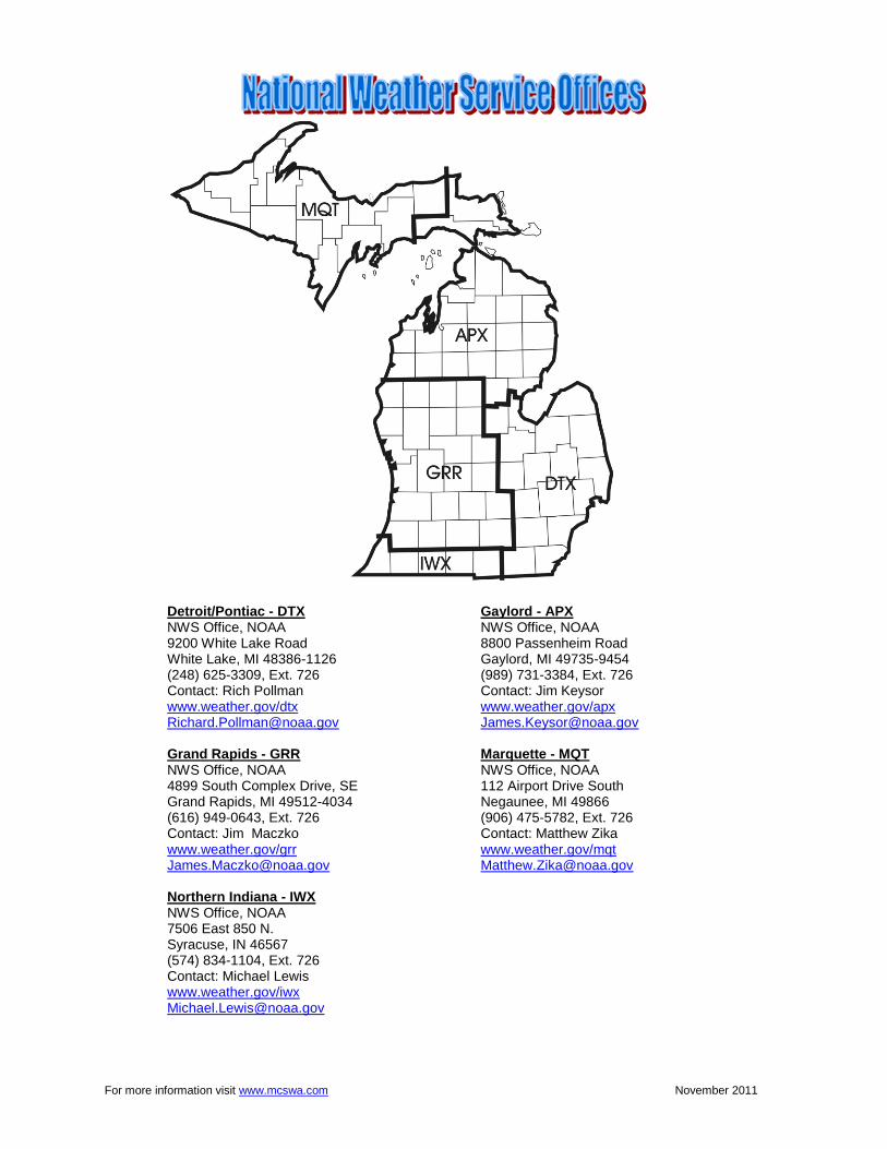
Detroit/Pontiac - DTX Gaylord - APX NWS Office, NOAA NWS Office, NOAA 9200 White Lake Road 8800 Passenheim Road White Lake, MI 48386-1126 Gaylord, MI 49735-9454 (248) 625-3309, Ext. 726 (989) 731-3384, Ext. 726 Contact: Rich Pollman Contact: Jim Keysor www.weather.gov/dtx www.weather.gov/apx [email protected] [email protected] Grand Rapids - GRR Marquette - MQT NWS Office, NOAA NWS Office, NOAA 4899 South Complex Drive, SE 112 Airport Drive South Grand Rapids, MI 49512-4034 Negaunee, MI 49866 (616) 949-0643, Ext. 726 (906) 475-5782, Ext. 726 Contact: Jim Maczko Contact: Matthew Zika www.weather.gov/grr www.weather.gov/mqt [email protected] [email protected] Northern Indiana - IWX NWS Office, NOAA 7506 East 850 N. Syracuse, IN 46567 (574) 834-1104, Ext. 726 Contact: Michael Lewis www.weather.gov/iwx [email protected]