2010 boater’s guide to cape cod - coastal...
TRANSCRIPT

2010 Boater’s Guide to Cape Cod
FREE
Schooner Mya ✯ Hyannis Port
Nantucket Soundkeeper is part of the global Waterkeeper Alliance of nearly 200 organizations that are working to protect and preserve their local waters from pollution and habitat loss. Soundkeeper programs are administered by the Cape Cod Commercial Hook Fishermen’s Association (CCCHFA), a non-profit dedicated to protecting the marine environment and the economic interests of our historic fishing community. Soundkeeper initiatives include publishing the Boater’s Guides series to encourage safe and environmentally friendly boating and fishing; monitoring water quality at numerous sites throughout the Sound in cooperation with PCCS; and helping restore natural habitats. For example, we recently completed a project to improve access for river herring and American eels migrating to their spawning grounds in Pilgrim Lake in Orleans. It is hoped that such restoration projects will support the resurgence of depleted herring stocks on Cape Cod.
Nantucket Soundkeeperc/o Cape Cod Commercial Hook Fishermen’s Association210 Orleans Road, North Chatham, MA 02650508-945-2432 • www.ccchfa.org
Provincetown Center for Coastal Studies (PCCS) sits at the end of the land and the beginning of the sea. From our vantage point at the tip of Cape Cod, we conduct scientific research on marine mammals and on the coastal and marine habitats and resources of Cape Cod Bay and the greater Gulf of Maine. Our research and educational programs are intended to encourage the responsible use and conservation of these ecosystems. To help achieve these ends, we collaborate with local organizations like the CCCHFA, Cape towns, and many agencies and institutions including the New England Aquarium, U.S. Coast Guard, the National Park Service, the National Marine Fisheries Service, and the Canadian Department of Fisheries and Oceans.
Provincetown Center for Coastal Studies115 Bradford Street, Provincetown, MA 01657508-487-3622 ext 113 • www.coastalstudies.org
Pleasant Bay Alliance was formed in 1998 by the Towns of Orleans, Chatham, Harwich, and Brewster to oversee implementation of the resource management plan for the Pleasant Bay Area of Critical Environmental Concern and the watershed. The Alliance promotes the health and safe public enjoyment of Pleasant Bay’s natural resources. Our programs encompass technical research, policy analysis, and public outreach in the areas of coastal processes, watershed planning, navigation, fisheries, wetlands protection, and water quality monitoring.
Pleasant Bay AlliancePO Box 1584, Harwich MA 02645 Tel. 508-430-2563 • Fax 508-432-3788 • www.pleasantbay.org

Protect Today, Preserve Forever.
a service of
2010 Boater’s Guide to Cape Cod
Pleasant Bay Alliance
which is a program of theCAPE COD COMMERCIAL HOOKFISHERMEN’S ASSOCIATION, Inc.CCCHFA is an equal opportunity provider and employer, United States Department of Agriculture cooperating.

GUIDE CONTENTS
Cape Cod Waters ________________________________________________4
Pleasant Bay __________________________________________________ 12
Whale Watching Guidelines _____________________________________16
Seal Watching Guidelines _______________________________________19
Trying Conservation Moorings to Save Eelgrass ___________________ 20
Tidal Currents ________________________________________________ 22
Tides of Cape Cod Bay & Nantucket Sound ______________________ 23
Green Boating Tips ____________________________________________ 30
Recreational Fishing ___________________________________________ 34
Massachusetts Finfish Regulations: 2010 ________________________ 38
Boating Laws and Responsibilities ______________________________ 40
Pumpout Information __________________________________________47
Marinas ____________________________________________________52
Key Contact Numbers __________________________________________ 54
Tow Boat Services_______________________________________________56
Editor: Mark Weissman
Copyright © 2010 by Nantucket SoundkeeperBoating Laws and Responsibilities copyright © 2010 by Boat Ed. All rights reserved. No part may be reproduced in any form or by any process without permission in writing from Boat Ed. Effort has been made to make the information and graphics as complete and accurate as possible. All references have been compiled from sources believed to be reliable and to represent the best current opinion on the subject. Boat Ed is not responsible or liable for any claims, liabilities, damages, or other adverse effects or consequences to any person or property caused or alleged to be caused directly or indirectly from the application or use of this material.
Printed on recycled paper using vegetable based inks. Cover photo of the schooner Mya courtesy of Vicki Kennedy
© M
ark
Sc
ott
| D
rea
MSt
iMe.
co
M
Welcome to the 2010 Boater’s Guide
Whether you like sailing, fishing, or cruising, you’ll find the 2010 Boater’s Guide to Cape Cod a handy source of information. In one booklet we’ve collected tide tables, fishing regulations, boating laws, green boating tips, whale watching guidelines, and a whole lot more. The Guide is provided free of charge to promote safe, enjoyable, and environmentally friendly boating in these beautiful waters.
Cape Cod is a very special place. It has a rich history shaping the culture and providing sustenance for the people who live around it. At heart, it is wild and raw. But on calm, sunny days in summer, it accommodates thousands of people who recreate on its shores and in its waters. Cape Cod Bay and Nantucket Sound support commercial fishermen who depend on their rich fishing grounds for their livelihood, and recreational anglers who rely on these waters to put food on their tables and invigorate their spirits. The Bay and Sound truly drive our economy and nurture our souls.
Nantucket Soundkeeper is a member of the Waterkeeper Alliance, an international environmental organization led by Robert F. Kennedy, Jr. Like the other “Waterkeepers,” our mission is to protect and preserve the health of our local waters. One of our priorities is to have all of Nantucket Sound designated as a “No Discharge Area (NDA)” by the Commonwealth and the US EPA. This designation would ban discharging sewage overboard from marine heads and help preserve the water quality of the Sound.
The Provincetown Center for Coastal Studies monitors the water quality of Cape Cod Bay, and studies the biology and habitat requirements of the humpback whale and the North Atlantic right whale. Since 1984, under federal permits, our technical team has freed more than 90 large whales from life threatening entanglements, using techniques developed by Center staff. PCCS has also disentangled dolphins and porpoises, seals and sea turtles. Please report marine mammal and turtle entanglements to 1-800-900-3622.
Boaters have a special responsibility and incentive to act as stewards of the Bay and the Sound—it’s for the sake of our families and boating companions, for ourselves, and for future generations. We wish you an environmentally friendly boating season.
Looking forward to seeing you on the water,
SUSAN L. NICKERSON RICHARD DELANEY
Nantucket Soundkeeper Provincetown Center for Coastal Studies
3

4
CAPE COD WATERSA National Treasure
We are a community of people drawn to the sea as sightseers, swimmers, sailors, fishermen or beachcombers. We are thankful for, and jealously seek to protect, the open space of the ocean around us. There is no other part of our community that offers more sweeping vistas, wildlife diversity and a place of refuge from the steady march of development.”
Barnstable Land Trust
“I surrendered myself to the sea and the wind and the sun and the stars on these voyages. I let my mind drift...to the momentous joy I have always felt at the way a sailboat moves through the water. “
Edward M. Kennedy, True Compass
C ape Cod Bay and Nantucket Sound are separated by only a few miles of glacial debris left by the last ice age—the arm of Cape Cod. Both have varied habitats including open waters, shallow shoals, estuaries, bays, salt marshes and barrier beaches, which support a great diversity
of wildlife. Cape Cod is a bio-geographic boundary between the warmer waters of the Mid-Atlantic Bight—the Sound being at its northeast end, and the cooler waters of the Gulf of Maine, the Bay being at its southwest end. The Sound has a unique ecology because two major ocean currents meet and mix there—the cold Labrador Current and warm Gulf Stream. Their waters bring together northern and southern species of marine life, creating an extreme richness of biological diversity and productivity. Cape Cod Bay, on the northern side of the peninsula, is primarily influenced by the Labrador Current. Upwelling nutrients just offshore create an explosion of wildlife there as well, favoring colder water species including cod, lobsters, humpbacks and North Atlantic right whales, and bluefin tuna.
Cape Cod Bay
BuzzardsBay
Nantucket
Martha’s Vineyard
Nantucket Sound

5
These rich waters are meccas for boaters. Many thousands of private boats call Cape towns their homeports. Thousands more cruise in from Maine to Florida or come over the Sagamore and Bourne Bridges on trailers and cartops bound for local boat ramps. The Cape has long been one of the most popular summer resorts in America. But all this popularity is not necessarily a good thing. It can stress natural systems beyond their ability to cope. Depending on your boating practices, you can add to the problem or become a part of the solution. You’ll see how later in the Boater’s Guide.
The Wealth of WildlifeCOUNTLESS BIRDS
One of the major migratory bird routes in North America crosses Cape Cod Bay and Nantucket Sound. During spring and fall migrations, tremendous flocks of birds use the shoals, the near-shore waters, and the shorelines for breeding, resting, and feeding. Hundreds of thousands of long-tailed ducks, eiders, scoters, buffleheads, and other diving ducks winter over, feeding on mussels, forage fish, and other marine life. The salt marshes, estuaries, and beaches provide nesting and feeding grounds for countless gulls, terns, brants, mergansers, endangered roseate terns and piping plovers, geese, herons, and many other species. Seasonally, there are great numbers of gannets, shearwaters, and storm petrels in the Bay. In the spring, you may be lucky enough to see the spectacular dives of ospreys fishing for alewives and blueback herring.
FAMOUS FISHING GROUNDS
The waters north and south of the Cape are historically significant fishing grounds. Hundreds of people are currently employed in commercial fisheries, while hundreds of thousands of recreational anglers try their luck here. The Atlantic cod is recognized as a symbol of the Commonwealth’s natural heritage. Cod was so important in the early history of the settlement of the Massachusetts coast that a wooden model (referred to as the “Sacred Cod”) hangs in the statehouse. Cape Cod Bay is an important cod nursery area. It supports a number of other commercial and recreational fisheries, ranging from lobsters to striped bass to bluefin tuna. The Bay is also known for its shellfish aquaculture, particularly for Wellfleet oysters, although there is considerable aquaculture of oysters and quahogs (littlenecks and cherrystones) in Brewster, Duxbury Bay, and Provincetown harbor, as well.
BRANTS OFF POPPONESSET BEACH

6
Cape Cod Bay is the southern range for many Northern Atlantic species, and Nantucket Sound is the northern range for most Mid-Atlantic species. The latter include black sea bass, scup, f luke, and loligo squid. These species can also be found in the Bay but favor the warmer
summer waters of the Sound. Every fall, when the Massachusetts Division of Marine Fisheries conducts trawl surveys, the nets come over the side loaded with so-called “young-of-the-year” scup, black sea bass, butterfish, and other species. These catches in the Sound far outweigh the Bay. The success of spawning and juvenile development activities of some of these species in the Sound may impact abundance levels down as far as the Mid-Atlantic states due to their migratory patterns. Striped bass migrate through the Sound in spring and fall but prefer cooler waters in mid-summer. Summer game fish in the Sound, such as Spanish mackerel, bonito, and false albacore, in general don’t make an annual migratory trip through the Cape Cod Canal or around the backside of the Cape, as do stripers, bluefish, mackerel, and other species.
PROTECTING HERRING
Herring species occur in great abundance all around Cape Cod and are a crucial source of food for many of the larger fish that dwell in our nearshore and offshore waters, including striped bass, bluefish, groundfish such as fluke and cod, and the tunas. Cape Cod and the Islands have dozens of active river herring runs where these anadromous fish come to spawn in the spring. Our two species of river herring–alewives and bluebacks–have been in precipitous declines in recent years. River herring are currently listed as “a species of concern” by the National Marine Fisheries Service. The Massachusetts Division of Marine Fisheries announced a fishing moratorium in 2005 that is still in effect. In the past couple of years, in some runs, declines seem to have stabilized, but populations still remain well below long term averages. Many explanations have been put forth for the declines, which are coastwide. Herring run disrepair and stream obstructions are factors that need to be addressed. Another problem is commercial by-catch in the Atlantic or sea herring fishery. When they are not spawning, river herring intermingle offshore with vast numbers of Atlantic herring, which is commercially fished for bait and food. Data from fisheries observers indicate that while there were relatively few observed incidents of river herring by-catch, they do happen episodically and can be substantial, given the outsized catches of the Atlantic herring fishery. There could be significant impacts on herring runs.
SCHOOLING POLLOCK

7
One of the cornerstone advocacy programs at the Cape Cod Commercial Hook Fishermen’s Association (CCCHFA), parent organization of the Nantucket Soundkeeper, is pushing for reforms to limit excessive fishing pressure and protect sea herring and all the fish, fisheries, and jobs that depend on them. By protecting sea herring, river herring are also benefitted. On a second front, the habitat problems causing river herring decline are being addressed by the Nantucket Soundkeeper. Along with other Cape Cod herring advocates, we are undertaking projects to remediate local rivers and streams on which river herring depend for spring spawning.
MARINE MAMMALS
Cape Cod Bay is a federally protected feeding ground for the critically endangered North Atlantic right whale and is a significant feeding area for the endangered humpback whale. Right whales occupy the Bay generally from March through June, while humpbacks are usually in the Bay from April through December. Other whales that frequent Cape Cod Bay are fin, minke, and pilot whales. In addition to these larger marine mammals, the Bay is frequented by white-sided and common dolphins, harbor porpoises, and sometimes the white-beaked dolphin. Harbor seals are also seen around the Bay, and they have a large haul-out on Jeremy Point in Wellfleet. The more northern seal species—harp, ringed, and hooded seals—are seen in winter months.
Nantucket Sound has only infrequent sightings of large whale species, but other marine mammals are commonly found here—either migrating through or taking up permanent residence. Noteworthy are gray seals, harbor seals, and harbor porpoises. Once hunted to the edge of extinction within the Gulf of Maine, today the largest gray seal pupping colony is on Muskeget Island off Nantucket. You can often find herds sunning themselves on the shores of Monomoy Island off Chatham.
A FEEDING HUMPBACK WHALE
PHO
TO: P
ROVI
NCE
TOW
N C
ENTE
R FO
R CO
ASTA
L ST
UDIE
S

SEA TURTLES
All sea turtles found in U.S. waters are protected under the federal Endangered Species Act. Four species occur in Cape waters: the loggerhead, leatherback, Kemp’s Ridley, and green. The leatherback is the largest of all sea turtles, while the Kemp’s Ridley is the smallest and most endangered. Strong swimming and deep diving, sea turtles have adapted to life in the ocean, but they must still come ashore to nest and lay eggs. Diamondback terrapins, the only brackish water species of turtle in Massachusetts, inhabit the shallow estuarine systems of Barnstable and Wellfleet harbors, Pleasant Bay, and Washburn Island (Falmouth). They nest in the adjacent sandy areas. The main threats to turtles are human-related. They include habitat degradation and destruction that impact nesting sites and feeding areas, incidental catches in fisheries, entanglement in marine debris, vessel strikes, and pollution. You can help sea turtles by picking up marine debris—especially floating plastic bags and balloons which are often mistaken for jellyfish, one of their main sources of food. If you encounter an entangled or injured sea turtle, call the Entanglement Response Hotline at 800-900-3622. If you find a stranded sea turtle on a beach on Cape Cod, call the MA Audubon Wellfleet Bay Wildlife Sanctuary at 508-349-2615.
LEATHERBACK TURTLE
Pollution Threatens the Sound
Boaters are naturally inclined to be environmentalists. We love nature and find joy in being out on the water. For the most part, the waters of the Sound and the Bay provide clean and healthy habitat for fish and other wildlife and attractive places for boating and
swimming. But signs of environmental degradation are showing up. Boating is part of the problem. However, the impaired water quality of the harbors, bays, and estuaries is a much bigger factor. In the last few decades, resident and visitor populations soared while responsible wastewater management lagged. According to the Cape Cod Commission, 80 percent of the 12 billion gallons of wastewater annually
PHO
TO C
REDI
T- K
ARA
DODG
E/ L
ARG
E PE
LAG
ICS
RESE
ARCH
CEN
TER
8

discharged into septic systems and cesspools leaches down into the aquifer and migrates slowly to our coastal ponds and estuaries. Runoff from roads, heavily fertilized lawns, golf courses, and town properties also enters inshore waters. The result of all these inputs is an excess of nutrients that causes noxious algae blooms in spring and summer, known as “eutrophication.” When boaters dump wastewater overboard, whether treated or not, they worsen the problem. Algae blooms have smothered many inshore eelgrass beds and turned thriving marine communities into underwater deserts. In 2005, an algae bloom caused a fish kill in the Mashpee River. Thousands of menhaden, silversides, and other small fish died and floated away. Since the Sound’s fisheries depend on these forage fish, what happens inshore will eventually be felt offshore. The potential long-term effects of eutrophication are serious, including declining fish and shellfish productivity. The Cape and Islands towns have begun addressing the problem with the technical and financial help of the Massachusetts Estuary Project (MEP)—a collaborative effort with the Department of Environmental Protection (DEP), the School for Marine Science and Technology (SMAST) at U. Mass. Dartmouth, the U.S. Environmental Protection Agency (EPA), and the Cape Cod Commission. Please check out www.mass.gov/dep/water/resources/coastalr.htm to learn more. According to the MEP, nitrogen inputs have to be slashed by 60-80% in the various watersheds. In some towns this will require large-scale conversion from private septic systems to municipal wastewater treatment systems. It will cost some towns hundreds of millions of dollars and could take decades or more to complete. In the meantime, an important question is what impacts are the over-fertilized waters having on the nearshore and offshore waters and habitats of Cape Cod Bay and Nantucket Sound? To find out, the Soundkeeper and PCCS conduct comprehensive water quality monitoring at numerous sites in the Bay and Sound. Measurements of nitrogen, chlorophyll, oxygen, and water clarity show that, overall, offshore waters appear to have high water quality. But between the shoreline and the near-shore stations a mile or so off the beach, some nitrogen-related impairment may be occurring. For example, the near-shore region from Yarmouth to Chatham has shown modest oxygen depletion. This is an indication that the nitrogen input to this region is beginning to exceed the tolerance of the system.
ALGAE COATS A SALT MARSH
9

Over the past four years, PCCS monitoring has consistently measured seasonal water quality impairment in the nearshore stations in Cape Cod Bay, noting lower levels of dissolved oxygen, higher levels of all forms of nutrients, and higher turbidity in the summer months. On-going results of the Cape Cod Bay Monitoring Program are posted online at www.coastalstudies.org. Besides septic systems, there are other sources of pollutants to the ground water aquifer, shellfish beds, salt marshes, and herring runs which need to be dealt with. Some good news is that the Cape Cod Water Resources Restoration Project has recently been authorized by the Senate Agriculture Committee to receive up to $22 million in federal funds. The monies will fund building structures to control storm water runoff, restoring fish ladders, and improving water flow to salt marshes.
WHAT BOATERS CAN DO TO HELP
All of us who sail, cruise, and fish need to learn how to practice “green boating” in order to protect these waters. This Guide has a lot of helpful information on the subject. The Office of Coastal Zone Management provides green boating tips regarding maintenance, fueling, and operation near sensitive wetlands. The Division of Marine Fisheries tells how to manage your boat’s head and wastewater disposal. Marine Fisheries also describes how thoughtful fishing practices can help protect fish stocks. If you have a home on the Cape or Islands, you have many opportunities to help reduce runoff problems. Love your lawn wisely—fertilize lightly, infrequently, and with slow-dissolving products, or better, use no fertilizer. And ask your neighbors to do the same. Remember, excess fertilizer washes off your yard and can end up in coastal waters. Eliminate or minimize pesticide and herbicide use. The stuff ends up where you boat. Another good idea is to pick up after your cat or dog. Pet wastes can seep into the soil or wash into storm drains, bringing bacteria and more nitrogen to coastal waters.
wCape Cod Bay and Nantucket Sound waters are held in the public trust. That is long-standing law that protects our collective interests as members of the public. Boaters have a special responsibility and incentive to act as stewards—for the sake of our families and boating companions, for ourselves, and for future generations. Protect what you love–do your part to protect the Bay and the Sound today.
MARC COSTA, PCCS, RETRIEVES A WATER SAMPLING INSTRUMENT.
10

11
THANK YOU!
The Provincetown Center for Coastal Studies is grateful to the many members and friends of the Center whose contributions have made it possible for us to publish the 2010 Boater’s Guide. We are most grateful for a generous bequest from Wendy Joan Shadwell, curator of prints at the New York Historical Society (1974-2002), an avid whale watcher, and a great friend of the Provincetown Center for Coastal Studies.
And we especially thank: Nancy Poor Robert Ross Wilma Thompson Cape Cod Salties Sportfishing Club Randolph Richardson Mike Roffino and Scott Brizard
Fabulous Fried Seafood • Steamed Lobsters
Chatham Pier Fish Market(Formerly Nickerson’s Fish & Lobsters)
45 Barcliff Ave. Ext. Chatham Fish Pier, Chatham
508-945-FISH (3474)
Homemade“Chowdah” &Lobster Bisque
Open Daily 10-7 pm
Chatham Day Boat Cod • Haddock • Scallops • Oysters • Clams • Mussels • George’s Bank Tuna, Swordfish,
Our famous SANDLESS STEAMERS, LOBSTERS& SHELLFISH in OPEN OCEAN WATER TANKS!
Watch the boats unload their catch at our own fish pier!Direct from the boat to your plate!
See the seals while you visit!

12
AN AERIAL VIEW OF THE LARGEST ESTUARY ON CAPE COD.
To help maintain its water quality, the Environmental Protection Agency is expected to soon declare Pleasant Bay and Chatham Harbor a no discharge area, making it illegal to discharge vessel sewage overboard, even if treated.
PLEASANT BAYA Cherished Resource on the Lower Cape
P leasant Bay is an area of extraordinary natural resources and beauty. It encompasses two main basins, numerous salt ponds and coves, and three tidal rivers. Fresh water flows into the Bay from inland ponds, bogs, and swamps. This confluence of salt and fresh
water at the shore generates a variety of habitats that support scores of animal and plant species. Plant materials from the marshes and eelgrass beds provide the foundation for the food chain. The Bay’s protected shallows, flats, and salt marshes provide spawning grounds and nurseries for the fish, crustaceans, shellfish, and many other invertebrates. And the tidal flats, in turn, provide rich feeding grounds for migratory birds. The Pleasant Bay ecosystem is the largest estuary on Cape Cod and one of the most biologically diverse and productive marine habitats on the East Coast. This productivity is particularly appreciated by residents and visitors to the Bay who harvest clams and bay scallops. Other popular activities include fishing, sailing, wind surfing, power boating, kayaking, bird-watching, hiking on the beaches, and simply relaxing into the beautiful views.

13
The Ever-Changing Barrier Beach Pleasant Bay is bounded on the east by a section of the Nauset Barrier Beach, which lies within the boundary of the Cape Cod National Seashore, and to the south by Chatham Harbor. Pleasant Bay and Chatham Harbor exchange tidal waters with the Atlantic Ocean through two inlets formed by breaches in the barrier beach. One inlet formed across from Chatham Light in 1987
and another formed to the North during the 2007 Patriot’s Day storm. The 2007 “North Inlet” has increased both the tidal range and the volume of sea water exchanging with the Bay. A recent study predicts that over time the North Inlet will become the dominant and ultimately the single inlet and will begin to migrate south of its current location. Boaters should be aware that some published tide tables for Pleasant Bay haven’t taken into account the impact of the 2007 breach, which has resulted in earlier high tides, later low tides, and a greater tidal range. The 2010 Boater’s Guide tide tables use correction factors for Chatham Harbor (Fish Pier) based on recent NOAA measurements.
Taking Responsibility for the Health of the BayIn 1987 the Commonwealth of Massachusetts designated Pleasant Bay an Area of Critical Environ-mental Concern (ACEC). This action led the four surrounding towns—Orleans, Chatham, Harwich, and Brewster—to develop a Resource Management Plan for the Bay and its watershed and to create the Pleasant Bay Alliance to coordinate management activities. The Alliance pursues its mission through research, policy analysis, and public outreach and education. For more than a decade the Alliance communities have been studying the effects of nutrient loading on the health of the estuary. Using data collected by the Alliance, the Massachusetts Estuaries Project documented impaired or degraded habitat in several sub-embayments. The biggest culprit is nitrogen overloading, primarily from septic systems. The Alliance towns are exploring a range of strategies to limit watershed nitrogen sources including sewering, managing stormwater runoff, and minimizing the use of fertilizers.
PHoto: roB BerGH PHotoGraPHY
Resources in Pleasant Bay
• 9,000 acre estuary • 6,800 acres of salt water • 71 miles of shoreline • 1,100 acres of salt marsh • 1,807 acres of eelgrass • 5 small islands • 21,000 acre watershed

Designating the Bay a No Discharge Area Sewage discharged from boats into the Bay degrades its water quality. Sewage contains high concentrations of nitrogen, which can produce algal blooms. Algal blooms, in turn, can cause low dissolved oxygen concentrations that impact the health of fish and shellfish. Algal blooms can also block sunlight from eelgrass beds and cause die-off. The bacteria and viruses in vessel sewage can make shellfish unfit for human consumption and make our beaches unsafe for swimming. For all these reasons, the Pleasant Bay Alliance submitted an application to designate Pleasant Bay and Chatham Harbor as a No Discharge Area. The designation would make it illegal to discharge vessel sewage even if treated by a marine sanitation device. The Commonwealth of Massachusetts has approved the NDA designation, and a final decision by the Environmental Protection Agency is anticipated this summer. In the meantime, we urge boaters to use the free pumpout locations listed here.
What Can You Do to Protect Pleasant Bay and other Coastal Waters?
First and foremost…• Support the efforts in your town to address nutrient loading through wastewater management.
On your boat…• Use water-based hull painting products and solvents, which don’t contain dangerous and harmful volatile organic compounds.
• Use a drop cloth, vacuum sander, or other recovery system when hull scraping; dispose of all dust and scraps at dedicated waste sites in marinas or bring them to hazardous waste collection sites on designated days.
• Even non-toxic cleaning products can cause temporary harm to the environment. Always try cleaning with water and a coarse cloth or scrubber sponge first.
14
Free Pumpout Services in Pleasant Bay
Pumpout Phone VHFHours of
OperationPumpout Boat at Round Cove,
Harwich508-430-7532 68 On demand
Pumpout Trailer at Ryder’s Cove,
Chatham508-945-5185 66
M-F 8-5Sat 9-1
Pumpout Cart at Nauset Marine East
at Meetinghouse Pond, Orleans
508-255-3045 9 On demand

• Dispose of boat chemicals, used motor oil, anti-freeze and cleaning materials at dedicated waste sites in marinas or bring them to hazardous waste collection sites on designated days.
• Use a bilge “pillow” to absorb oil from bilge water so it isn’t pumped overboard.
• Don’t damage eelgrass beds by running your boat through them or anchoring in them.
In your home…• Use detergents and cleaning products that do not contain phosphorous.
• Eliminate or reduce use of polishes or industrial strength cleaners.
• Do not allow hazardous products to be flushed down drains; participate in local hazardous waste collection days.
In your yard...•Select grass types appropriate for the area, such as fescues mixed with rye grass.
•Keep grass 2-3 inches long and leave clippings when you mow.
•If you must use fertilizer, use a slow release organic type.
Clean up after your pet…Animal feces left on roadsides, walking paths, and beaches contributes nitrogen and bacteria to nearby wetlands and coastal waters. Many public access areas now have Mutt Mitt dispensers—but just to be sure—bring your own plastic bag to secure pet waste and dispose of it at home.
15
Orleans Pond Coalition
Please help keep our waters clean!
www.OrleansPondCoalition.org
. . . protecting all our waters

16
WHALE WATCHING GUIDELINES
HERE ARE SIX TIPS FOR SAFELY BOATING AROUND WHALES
1. See a tail or spout, Watch Out! If you see a whale, slow down and post a lookout to help monitor its movements. If you are within a mile, slow down to 10 knots. If within 600 feet, slow to no-wake speed. Avoid sudden changes in speed and direction.
2. Keep out of their way. Don’t steer head-on toward an approaching whale and don’t cut one off that’s approaching you at an angle. Parallel the course of moving whales.
3. Give whales space and don’t chase them. Approaching a whale too closely is harassment. Don’t get within 100 feet. If whales come within 100 feet of you, put your engine in neutral and don’t motor off until the whales are clear of harm’s way. And don’t intentionally drift down on them. Federal and state law make it illegal to approach within 500 yards of the endangered North Atlantic right whale. If a surfacing right whale puts you within the 500-yard buffer zone, move away slowly.
4. Keep in touch with other boaters. If other boats are around, call them on your VHF radio (Channels 9 or 16) to coordinate your movements. Whales can’t predict where boats are headed. You don’t want to box them in or cut off their movements.
5. Steer clear of bubbles. Humpback whales sometimes corral bait by creating “bubble clouds,” which look like light green, foamy patches on the water. A feeding whale is likely to be just below the surface.
6. Drop your sails when watching whales. Use your auxiliary motor for greater control of your speed and course.
Right whale sightings should be called in to 978-585-8473 (pager), the NOAA Fisheries Service Sighting Advisory System.
Sources: National Marine Fisheries Service and Whale and Dolphin Conservation Society
The waters around Cape Cod and the Islands are a seasonal home to whales, dolphins, and seals. The Marine Mammal Protection Act makes it a federal crime to harass, hunt, capture or kill them.
PHO
TO B
Y JO
HN
CH
ISH
OLM

17
If You Encounter an EntangledMarine Mammal or Turtle
Disentangling marine animals like this endangered humpback whale is dangerous work. The whale pictured above was safely disentangled in 2009, as was its mother in 2003. The PCCS marine animal entanglement response team has disentangled over 150 whales, seals and sea turtles and is on call to respond year round in southern New England, including the waters surrounding Cape Cod.
Entanglement in fishing gear is a known source of injury and mortality for whales and sea turtles. The Massachusetts Division of Marine Fisheries and the National Oceanic and Atmospheric Administration (NOAA) require sinking lines for lobster pots and gillnets to prevent or reduce the threat and harm from entanglement, and these agencies continue to work with fishermen to modify fishing gear and practices.
Entanglement poses a significant threat to endangered species, including right and humpback whales and leatherback turtles. A majority of right and humpback whales have been entangled at least once in their lives.
Mariners are urged to report sightings of entangled marine animals immediately and stand by the animal at a safe and legal distance. For your own safety and that of the entangled animal, DO NOT attempt to touch the animal or the gear, or attempt to disentangle the animal in any way. In many cases, an untrained disentanglement effort can be detrimental to the animal and result in serious injury to the people involved.
PH
OTO
: PR
OV
INC
ETO
WN
CE
NTE
R F
OR
CO
AST
AL
STU
DIE
S. T
AK
EN
U
ND
ER
NO
AA
PE
RM
IT 9
32-1
489,
WIT
H A
UTH
OR
ITY
OF
THE
US
ESA
.

18
If you sight any entangled marine animal, please call the Entanglement Response Hotline at 800-900-3622 or NOAA Fisheries at: 866-755-6622 (or hail the Coast Guard on Channel 16) and be prepared to provide the following information:
Contact Information: A contact phone number, or if VHF is the only available communication, your vessel name and the channel you will be monitoring.
Sightings Information:
• Time of sighting
• GPS Location - if unable to give lat/long then specific geographic directions (distance from shore, and any on-shore landmarks)
• Estimated length of the animal
• Description of the animal (color, body shape, behavior)
• Description of the gear entangling the animal (color of line, shape and color of any buoys, number of buoys involved in the entanglement)
• Documentation of the animal and the gear using any means available (camera, video, or cell phone camera)
After you call, stand by. Stay with the animal at a safe distance (~200-300 feet) until a responder arrives. If you are unable to stand by, provide information on other vessels in the area that may be able to relieve you.
19
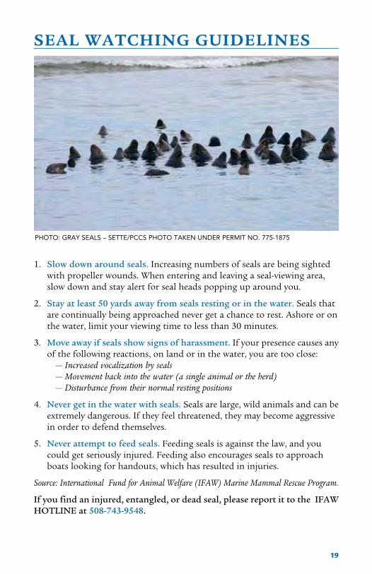
SEAL WATCHING GUIDELINES
1. Slow down around seals. Increasing numbers of seals are being sighted with propeller wounds. When entering and leaving a seal-viewing area, slow down and stay alert for seal heads popping up around you.
2. Stay at least 50 yards away from seals resting or in the water. Seals that are continually being approached never get a chance to rest. Ashore or on the water, limit your viewing time to less than 30 minutes.
3. Move away if seals show signs of harassment. If your presence causes any of the following reactions, on land or in the water, you are too close: — Increased vocalization by seals — Movement back into the water (a single animal or the herd) — Disturbance from their normal resting positions
4. Never get in the water with seals. Seals are large, wild animals and can be extremely dangerous. If they feel threatened, they may become aggressive in order to defend themselves.
5. Never attempt to feed seals. Feeding seals is against the law, and you could get seriously injured. Feeding also encourages seals to approach boats looking for handouts, which has resulted in injuries.
Source: International Fund for Animal Welfare (IFAW) Marine Mammal Rescue Program.
If you find an injured, entangled, or dead seal, please report it to the IFAW HOTLINE at 508-743-9548.
PHOTO: GRAY SEALS – SETTE/PCCS PHOTO TAKEN UNDER PERMIT NO. 775-1875

20
Trying “Conservation Moorings” to Save EelgrassEelgrass meadows are a key feature of healthy, shallow embayments in Massachusetts. Eel- grass (Zostera marina) provides sheltering and foraging habitat for crustaceans, juvenile finfish including winter flounder, and shellfish such as bay scallops. Eelgrass plays a role in pollutant removal and nutrient cycling through the ecosystem. The long fronds dampen waves and reduce currents, which can reduce erosion. Extensive meadows were once found in many
Cape and Islands harbors and coastal ponds, but in recent years they have greatly declined or disappeared entirely.
Human activities are largely responsible for the loss of eelgrass communities. Excess nitrogen leaching into the bays from septic systems, fertilizers, and stormwater runoff promotes algae blooms, which block the sunlight eelgrass needs to grow. There are also direct impacts from boat propellers and anchors, dock building, and other development activities. In 2007 an aerial survey conducted by scientists from the Provincetown Center for Coastal Studies (PCCS) and the LightHawk Volunteer Aviators documented another human impact: the physical damage to eelgrass beds from traditional mooring systems. This aerial photo of Provincetown Harbor shows the circular scars on the seabed caused by heavy mooring chains swinging around with the tides. Chain sweep also raises sediment that clouds the water and reduces sunlight penetration, further degrading eelgrass in nearby areas.
This year, help is on the way for Provincetown Harbor. A pilot eelgrass restoration project is being led by the Massachusetts Bays Program (MBP), in partnership with the Division of Marine Fisheries (DMF), the Association to Preserve Cape Cod, and the Provincetown harbormaster. To eliminate damage from chain sweep, seven concrete block- and-chain moorings will be removed and replaced with “conservation moorings” –a helical anchor screwed into the seabed with a tough rubber cord in place of the chain, and a float to keep the cord off the bottom. In addition, eelgrass will be transplanted into the mooring scars by divers from DMF and the Environmental Protection Agency (EPA). The results of these efforts will be eagerly monitored to determine whether these conservation moorings can, as believed, significantly reduce the impact of mooring systems on eelgrass beds.
For more information, or to volunteer for the project, contact Jay Baker, MBP Director at [email protected].
This project is funded through a grant from the Association of National Estuary Programs and the National Oceanic and Atmospheric Administration. The Nature Conservancy provided additional support .
MOORING SCARS IN PROVINCETOWN HARBOR

21
Your Source for All Things Marine in MassachusettsBoats, Marine services & accessories
new & Pre-owned Boat dealersMassachusetts Marinas
local Predicted tide taBles Boat shows / current events
Kids, Boating & FunMarine & weather weBcaMsBoating saFety inForMation
Ma on-line Boat registrationthe environMent & Boating
Boating laws & youweather & Fishing linKs access/raMP locations
Marine industry careers & education legislation aFFecting Boaters
Visit: WWW.BOATMA.COM
www.staylocalboatma.com

22
TIDAL CURRENTS
T ides rise and fall, but incoming and outgoing tidal currents flow horizontally. The strongest currents around Cape Cod are funneled between the Vineyard and Falmouth, alongside Chappaquiddick and Monomoy, around Race Point, in the narrow inlets to bays, and across
shallows such as Horseshoe Shoal.
One cycle of tides and tidal currents takes half a lunar orbit, about 12 hours and 25 minutes. The tide floods in with increasing speed until it reaches maximum velocity. Then the current slows until there is little or no movement (slack water) and it reverses direction. The tide ebbs in a similar fashion, faster then slower until it reaches slack water, and the cycle repeats. The relationship between tidal currents and tide times is complex and depends on water depths and nearby landmasses. Slack water can occur at high and low tides, or halfway between, or in some other pattern.
The incoming tide for Cape Cod Bay floods to the west and south around Race Point, joins the current flooding south past Scituate and Plymouth, and sweeps into the Bay in a counter-clockwise motion. The tide ebbs north and east, sweeping back up the coast and around Race Point out to sea. In Nantucket Sound, the tide floods to the east and ebbs to the west.
Because tidal currents affect navigation, fishing, and sailing, using current tables can make the difference between a good day on the water and a frustrating one. Learn the patterns where you boat by reading the water. At high and low tides, how do the currents run? There is an excellent, animated graphic of currents at www.sailflow.com. Select MA-Cape Cod as your home region and click on Tidal Currents. To print out current predictions, go to www.tidesandcurrents.noaa.gov/currents10/cpred2.html#MA.
For sailboats and low-powered boats, attention MUST be paid to tidal currents and also wind conditions. Strong winds increase tidal currents or interfere with them. In the Sound, where the prevailing summer wind is from the southwest, a sailboat will make little way into SW winds on a flooding tide. Similarly, a small engine can struggle to make headway against a strong current in a narrow inlet. When strong currents encounter strong winds coming from the opposite direction, you should expect choppy conditions. A useful website for marine weather forecasts is www.capecodweather.net.
For fishermen, knowing the currents can be as important as knowing the hot spots to fish. Currents help to concentrate bait, which attracts game fish. At slack tide, fish tend to disperse. You could find yourself racing from one slow fishing spot to the next — or be at a good spot when the tide was running just right. Check out The Fisherman’s Ocean by David A. Ross, PhD., for a clear, practical discussion of how to use marine science to increase fishing success.

23
THE TIDES OF CAPE COD BAY& NANTUCKET SOUND
In the middle of Cape Cod Bay, you have more than a hundred feet of water underyour keel. In the middle of Nantucket Sound, your keel and prop might scrape the tops of shoals. The Bay resembles a deep cup, while the Sound is generally shallower and full of submerged sand and gravel bars deposited by
the receding glacier of the last ice age. In both bodies of water, inshore depths are usually shallow enough to warrant your paying close attention to depth finders, navigation buoys–and tide tables.
The heights and times of our tides vary considerably. At Plymouth, Barnstable, and Provincetown Harbors, daily tidal ranges can exceed 11 feet. Low tide in the Bay exposes wide tidal flats from Dennis eastward to Provincetown–in some places extending more than a half-mile from the beach. High and low tides at most Bay locations occur within minutes of each other. In contrast the tidal range of the Sound is a few feet or less, but the times can vary by an hour or more. For example, on July 4, 2010, it is high tide at Falmouth at 4:59 AM (1.29') and at Nantucket at 6:21 AM (3.22').
Tides result from the gravitational attraction of the sun and the moon on the earth and its oceans. The moon, because it’s much closer than the sun, exerts the most influence on the tides. One high tide occurs at the point on the earth that is closest to the moon, where the ocean bulges up. At the same time, on the opposite side of the earth where the moon’s pull is the weakest, centrifugal force causes the ocean to bulge outward causing another high tide. These two high tide bulges stay in place as the earth rotates and the moon orbits the earth every 24 hours and 50 minutes. That’s why there are usually two high and low tides a day, each tidal cycle lasting about 12 hours and 25 minutes.
Twice a month, at full moon and new moon when the sun and the moon line up, their combined gravitational pull produces the highest tides, called “spring tides.” (Think of the water springing up, not the season.) Full moon and new moon are also when the low tides are their lowest. At first quarter and last quarter moons, the tides are their weakest with lower highs and higher lows. These are called “neap tides.” Weather also affects tidal heights. Usually, onshore winds or low barometric pressure will produce higher tides than predicted and vice versa.
Data for the tide tables that follow were generously provided by the Massachusetts Marine Trades Association (MMTA). For additional locations, see www.boatma.com/tides.
Disclaimer: While taking care to make these tide charts as accurate as possible, MMTA does not warrant the accuracy, completeness, or fitness for a particular purpose of any tide information offered through this service. Under no circumstances shall MMTA be liable to you or any other person for any indirect, special, incidental, or consequential damages arising from the use of this service.

24
TIDESJUNE2010
BARNSTABLE FALMOUTH HYANNIS PORT QTRHIGH LOW HIGH LOW HIGH LOW
AM PM AM PM AM PM AM PM AM PM AM PM
1 Tue
2 Wed
3 Thu
4 Fri
5 Sat
6 Sun
7 Mon
8 Tue
9 Wed
10 Thu
11 Fri
12 Sat
13 Sun
14 Mon
15 Tue
16 Wed
17 Thu
18 Fri
19 Sat
20 Sun
21 Mon
22 Tue
23 Wed
24 Thu
25 Fri
26 Sat
27 Sun
28 Mon
29 Tue
30 Wed
2:52 3:32 9:34 9:46
3:38 4:18 10:19 10:34
4:26 5:04 11:04 11:24
5:16 5:52 11:51 –
6:08 6:40 12:16 12:40
7:01 7:28 1:10 1:29
7:55 8:17 2:04 2:18
8:48 9:04 2:56 3:08
9:39 9:51 3:47 3:56
10:29 10:37 4:36 4:44
11:18 11:24 5:24 5:32
– 12:06 6:11 6:19
12:11 12:53 6:59 7:08
1:00 1:43 7:47 7:58
1:50 2:32 8:36 8:50
2:43 3:24 9:26 9:45
3:37 4:17 10:18 10:41
4:35 5:12 11:12 11:41
5:34 6:09 – 12:07
6:36 7:06 12:42 1:04
7:39 8:04 1:45 2:01
8:41 9:00 2:47 2:58
9:42 9:54 3:46 3:54
10:38 10:46 4:41 4:46
11:29 11:34 5:32 5:36
– 12:16 6:19 6:23
12:19 12:59 7:03 7:07
1:02 1:41 7:44 7:51
1:44 2:21 8:24 8:34
2:26 3:01 9:04 9:17
3:44 4:24 9:35 9:47
4:30 5:10 10:20 10:35
5:18 5:56 11:05 11:25
6:08 6:44 11:52 –
7:00 7:32 12:17 12:41
7:53 8:20 1:11 1:30
8:47 9:09 2:05 2:19
9:40 9:56 2:57 3:09
10:31 10:43 3:48 3:57
11:21 11:29 4:37 4:45
– 12:10 5:25 5:33
12:16 12:58 6:12 6:20
1:03 1:45 7:00 7:09
1:52 2:35 7:48 7:59
2:42 3:24 8:37 8:51
3:35 4:16 9:27 9:46
4:29 5:09 10:19 10:42
5:27 6:04 11:13 11:42
6:26 7:01 – 12:08
7:28 7:58 12:43 1:05
8:31 8:56 1:46 2:02
9:33 9:52 2:48 2:59
10:34 10:46 3:47 3:55
11:30 11:38 4:42 4:47
– 12:21 5:33 5:37
12:26 1:08 6:20 6:24
1:11 1:51 7:04 7:08
1:54 2:33 7:45 7:52
2:36 3:13 8:25 8:35
3:18 3:53 9:05 9:18
2:25 3:05 8:55 9:07
3:11 3:51 9:40 9:55
3:59 4:37 10:25 10:45
4:49 5:25 11:12 11:37
5:41 6:13 12:01 –
6:34 7:01 12:31 12:50
7:28 7:50 1:25 1:39
8:21 8:37 2:17 2:29
9:12 9:24 3:08 3:17
10:02 10:10 3:57 4:05
10:51 10:57 4:45 4:53
11:39 11:44 5:32 5:40
12:26 – 6:20 6:29
12:33 1:16 7:08 7:19
1:23 2:05 7:57 8:11
2:16 2:57 8:47 9:06
3:10 3:50 9:39 10:02
4:08 4:45 10:33 11:02
5:07 5:42 11:28 –
6:09 6:39 12:03 12:25
7:12 7:37 1:06 1:22
8:14 8:33 2:08 2:19
9:15 9:27 3:07 3:15
10:11 10:19 4:02 4:07
11:02 11:07 4:53 4:57
11:49 11:52 5:40 5:44
12:32 – 6:24 6:28
12:35 1:14 7:05 7:12
1:17 1:54 7:45 7:55
1:59 2:34 8:25 8:38
BARNSTABLE HIgH LOwBoston -0:11 -0:30Plymouth -0:07 -0:12Canal Entrance East -0:12 -0:33Provincetown +0:05 -0:12
HIgH LOwVineyard Haven -0:37 -0:24Oak Bluffs -0:28 -0:38Edgartown -0:03 -0:12Nantucket +0:05 +0:10
HIgH LOwPopponesset Bay +1:03 +1:26Bass River Bridge +0:48 +1:20Stage Harbor -0:06 -0:17Chatham Harbor Fish Pier -0:15 +0:33
HYANNIS
For the following locations, add or subtract these average differences from the same tides at:

25
TIDESJULY2010
BARNSTABLE FALMOUTH HYANNIS PORT QTRHIGH LOW HIGH LOW HIGH LOW
AM PM AM PM AM PM AM PM AM PM AM PM
1 Thu
2 Fri
3 Sat
4 Sun
5 Mon
6 Tue
7 Wed
8 Thu
9 Fri
10 Sat
11 Sun
12 Mon
13 Tue
14 Wed
15 Thu
16 Fri
17 Sat
18 Sun
19 Mon
20 Tue
21 Wed
22 Thu
23 Fri
24 Sat
25 Sun
26 Mon
27 Tue
28 Wed
29 Thu
30 Fri
31 Sat
3:08 3:42 9:45 10:01
3:52 4:24 10:26 10:48
4:38 5:07 11:09 11:36
5:26 5:53 11:54 –
6:17 6:41 12:28 12:43
7:11 7:30 1:21 1:33
8:06 8:22 2:16 2:25
9:01 9:14 3:10 3:19
9:56 10:06 4:04 4:12
10:49 10:58 4:56 5:05
11:40 11:50 5:47 5:56
– 12:31 6:37 6:48
12:42 1:21 7:26 7:40
1:34 2:11 8:15 8:33
2:27 3:02 9:05 9:27
3:21 3:55 9:56 10:23
4:18 4:49 10:48 11:22
5:16 5:44 11:43 –
6:17 6:42 12:22 12:39
7:21 7:42 1:25 1:38
8:25 8:41 2:29 2:37
9:26 9:38 3:30 3:35
10:22 10:30 4:26 4:29
11:12 11:18 5:17 5:18
11:56 – 6:01 6:03
12:01 12:37 6:41 6:46
12:41 1:14 7:19 7:27
1:21 1:51 7:56 8:07
1:59 2:27 8:33 8:48
2:39 3:05 9:10 9:29
3:20 3:43 9:49 10:13
4:00 4:34 9:46 10:02
4:44 5:16 10:27 10:49
5:30 5:59 11:10 11:37
6:18 6:45 11:55 –
7:09 7:33 12:29 12:44
8:03 8:22 1:22 1:34
8:58 9:14 2:17 2:26
9:53 10:06 3:11 3:20
10:48 10:58 4:05 4:13
11:41 11:50 4:57 5:06
– 12:32 5:48 5:57
12:42 1:23 6:38 6:49
1:34 2:13 7:27 7:41
2:26 3:03 8:16 8:34
3:19 3:54 9:06 9:28
4:13 4:47 9:57 10:24
5:10 5:41 10:49 11:23
6:08 6:36 11:44 –
7:09 7:34 12:23 12:40
8:13 8:34 1:26 1:39
9:17 9:33 2:30 2:38
10:18 10:30 3:31 3:36
11:14 11:22 4:27 4:30
– 12:04 5:18 5:19
12:10 12:48 6:02 6:04
12:53 1:29 6:42 6:47
1:33 2:06 7:20 7:28
2:13 2:43 7:57 8:08
2:51 3:19 8:34 8:49
3:31 3:57 9:11 9:30
4:12 4:35 9:50 10:14
2:41 3:15 9:06 9:22
3:25 3:57 9:47 10:09
4:11 4:40 10:30 10:57
4:59 5:26 11:15 11:49
5:50 6:14 12:04 –
6:44 7:03 12:42 12:54
7:39 7:55 1:37 1:46
8:34 8:47 2:31 2:40
9:29 9:39 3:25 3:33
10:22 10:31 4:17 4:26
11:13 11:23 5:08 5:17
12:04 – 5:58 6:09
12:15 12:54 6:47 7:01
1:07 1:44 7:36 7:54
2:00 2:35 8:26 8:48
2:54 3:28 9:17 9:44
3:51 4:22 10:09 10:43
4:49 5:17 11:04 11:43
5:50 6:15 12:00 –
6:54 7:15 12:46 12:59
7:58 8:14 1:50 1:58
8:59 9:11 2:51 2:56
9:55 10:03 3:47 3:50
10:45 10:51 4:38 4:39
11:29 11:34 5:22 5:24
12:10 – 6:02 6:07
12:14 12:47 6:40 6:48
12:54 1:24 7:17 7:28
1:32 2:00 7:54 8:09
2:12 2:38 8:31 8:50
2:53 3:16 9:10 9:34
BARNSTABLE HIgH LOwBoston -0:11 -0:30Plymouth -0:07 -0:12Canal Entrance East -0:12 -0:33Provincetown +0:05 -0:12
HIgH LOwVineyard Haven -0:37 -0:24Oak Bluffs -0:28 -0:38Edgartown -0:03 -0:12Nantucket +0:05 +0:10
HIgH LOwPopponesset Bay +1:03 +1:26Bass River Bridge +0:48 +1:20Stage Harbor -0:06 -0:17Chatham Harbor Fish Pier -0:15 +0:33
HYANNIS
For the following locations, add or subtract these average differences from the same tides at:

26
TIDESAUg2010
BARNSTABLE FALMOUTH HYANNIS PORT QTRHIGH LOW HIGH LOW HIGH LOW
AM PM AM PM AM PM AM PM AM PM AM PM
1 Sun
2 Mon
3 Tue
4 Wed
5 Thu
6 Fri
7 Sat
8 Sun
9 Mon
10 Tue
11 Wed
12 Thu
13 Fri
14 Sat
15 Sun
16 Mon
17 Tue
18 Wed
19 Thu
20 Fri
21 Sat
22 Sun
23 Mon
24 Tue
25 Wed
26 Thu
27 Fri
28 Sat
29 Sun
30 Mon
31 Tue
4:03 4:25 10:30 10:59
4:49 5:09 11:14 11:49
5:38 5:58 – 12:02
6:33 6:50 12:43 12:54
7:30 7:46 1:40 1:50
8:29 8:43 2:38 2:48
9:26 9:40 3:35 3:45
10:22 10:36 4:30 4:41
11:15 11:30 5:22 5:36
– 12:07 6:13 6:29
12:23 12:57 7:02 7:22
1:16 1:47 7:52 8:14
2:09 2:37 8:41 9:08
3:03 3:28 9:31 10:03
3:58 4:22 10:23 11:00
4:56 5:18 11:17 –
5:57 6:18 12:00 12:14
7:01 7:20 1:03 1:15
8:06 8:22 2:08 2:16
9:07 9:20 3:10 3:16
10:02 10:12 4:07 4:10
10:49 10:58 4:55 4:58
11:30 11:40 5:36 5:42
– 12:08 6:14 6:22
12:18 12:43 6:49 7:01
12:56 1:17 7:24 7:40
1:33 1:52 8:00 8:19
2:11 2:28 8:36 8:59
2:50 3:05 9:14 9:41
3:31 3:46 9:54 10:26
4:16 4:31 10:39 11:16
4:55 5:17 10:31 11:00
5:41 6:01 11:15 11:50
6:30 6:50 – 12:03
7:25 7:42 12:44 12:55
8:22 8:38 1:41 1:51
9:21 9:35 2:39 2:49
10:18 10:32 3:36 3:46
11:14 11:28 4:31 4:42
– 12:07 5:23 5:37
12:22 12:59 6:14 6:30
1:15 1:49 7:03 7:23
2:08 2:39 7:53 8:15
3:01 3:29 8:42 9:09
3:55 4:20 9:32 10:04
4:50 5:14 10:24 11:01
5:48 6:10 11:18 –
6:49 7:10 12:01 12:15
7:53 8:12 1:04 1:16
8:58 9:14 2:09 2:17
9:59 10:12 3:11 3:17
10:54 11:04 4:08 4:11
11:41 11:50 4:56 4:59
– 12:22 5:37 5:43
12:32 1:00 6:15 6:23
1:10 1:35 6:50 7:02
1:48 2:09 7:25 7:41
2:25 2:44 8:01 8:20
3:03 3:20 8:37 9:00
3:42 3:57 9:15 9:42
4:23 4:38 9:55 10:27
5:08 5:23 10:40 11:17
3:36 3:58 9:51 10:20
4:22 4:42 10:35 11:10
5:11 5:31 11:23 –
6:06 6:23 12:04 12:15
7:03 7:19 1:01 1:11
8:02 8:16 1:59 2:09
8:59 9:13 2:56 3:06
9:55 10:09 3:51 4:02
10:48 11:03 4:43 4:57
11:40 11:56 5:34 5:50
12:30 – 6:23 6:43
12:49 1:20 7:13 7:35
1:42 2:10 8:02 8:29
2:36 3:01 8:52 9:24
3:31 3:55 9:44 10:21
4:29 4:51 10:38 11:21
5:30 5:51 11:35 –
6:34 6:53 12:24 12:36
7:39 7:55 1:29 1:37
8:40 8:53 2:31 2:37
9:35 9:45 3:28 3:31
10:22 10:31 4:16 4:19
11:03 11:13 4:57 5:03
11:41 11:51 5:35 5:43
12:16 – 6:10 6:22
12:29 12:50 6:45 7:01
1:06 1:25 7:21 7:40
1:44 2:01 7:57 8:20
2:23 2:38 8:35 9:02
3:04 3:19 9:15 9:47
3:49 4:04 10:00 10:37
BARNSTABLE HIgH LOwBoston -0:11 -0:30Plymouth -0:07 -0:12Canal Entrance East -0:12 -0:33Provincetown +0:05 -0:12
HIgH LOwVineyard Haven -0:37 -0:24Oak Bluffs -0:28 -0:38Edgartown -0:03 -0:12Nantucket +0:05 +0:10
HIgH LOwPopponesset Bay +1:03 +1:26Bass River Bridge +0:48 +1:20Stage Harbor -0:06 -0:17Chatham Harbor Fish Pier -0:15 +0:33
HYANNIS
For the following locations, add or subtract these average differences from the same tides at:

27
TIDESSEPT2010
BARNSTABLE FALMOUTH HYANNIS PORT QTRHIGH LOW HIGH LOW HIGH LOW
AM PM AM PM AM PM AM PM AM PM AM PM
1 Wed
2 Thu
3 Fri
4 Sat
5 Sun
6 Mon
7 Tue
8 Wed
9 Thu
10 Fri
11 Sat
12 Sun
13 Mon
14 Tue
15 Wed
16 Thu
17 Fri
18 Sat
19 Sun
20 Mon
21 Tue
22 Wed
23 Thu
24 Fri
25 Sat
26 Sun
27 Mon
28 Tue
29 Wed
30 Thu
5:06 5:22 11:28 –
6:02 6:18 12:10 12:23
7:01 7:18 1:09 1:22
8:02 8:19 2:09 2:24
9:01 9:19 3:08 3:24
9:57 10:16 4:04 4:22
10:51 11:11 4:57 5:17
11:41 – 5:48 6:10
12:05 12:31 6:37 7:03
12:57 1:20 7:26 7:55
1:49 2:10 8:15 8:47
2:42 3:01 9:05 9:40
3:37 3:54 9:56 10:36
4:34 4:50 10:51 11:34
5:34 5:50 11:48 –
6:37 6:53 12:36 12:50
7:41 7:56 1:41 1:52
8:40 8:54 2:42 2:52
9:33 9:46 3:37 3:46
10:18 10:31 4:23 4:34
10:57 11:13 5:03 5:16
11:34 11:51 5:39 5:56
– 12:08 6:15 6:35
12:29 12:43 6:51 7:13
1:06 1:17 7:27 7:52
1:44 1:53 8:04 8:31
2:23 2:31 8:43 9:13
3:05 3:14 9:24 9:59
3:50 4:01 10:10 10:49
4:42 4:54 11:02 11:44
5:58 6:14 11:29 –
6:54 7:10 12:11 12:24
7:53 8:10 1:10 1:23
8:54 9:11 2:10 2:25
9:53 10:11 3:09 3:25
10:49 11:08 4:05 4:23
11:43 – 4:58 5:18
12:03 12:33 5:49 6:11
12:57 1:23 6:38 7:04
1:49 2:12 7:27 7:56
2:41 3:02 8:16 8:48
3:34 3:53 9:06 9:41
4:29 4:46 9:57 10:37
5:26 5:42 10:52 11:35
6:26 6:42 11:49 –
7:29 7:45 12:37 12:51
8:33 8:48 1:42 1:53
9:32 9:46 2:43 2:53
10:25 10:38 3:38 3:47
11:10 11:23 4:24 4:35
11:49 – 5:04 5:17
12:05 12:26 5:40 5:57
12:43 1:00 6:16 6:36
1:21 1:35 6:52 7:14
1:58 2:09 7:28 7:53
2:36 2:45 8:05 8:32
3:15 3:23 8:44 9:14
3:57 4:06 9:25 10:00
4:42 4:53 10:11 10:50
5:34 5:46 11:03 11:45
4:39 4:55 10:49 11:31
5:35 5:51 11:44 –
6:34 6:51 12:30 12:43
7:35 7:52 1:30 1:45
8:34 8:52 2:29 2:45
9:30 9:49 3:25 3:43
10:24 10:44 4:18 4:38
11:14 11:38 5:09 5:31
12:04 – 5:58 6:24
12:30 12:53 6:47 7:16
1:22 1:43 7:36 8:08
2:15 2:34 8:26 9:01
3:10 3:27 9:17 9:57
4:07 4:23 10:12 10:55
5:07 5:23 11:09 11:57
6:10 6:26 12:11 –
7:14 7:29 1:02 1:13
8:13 8:27 2:03 2:13
9:06 9:19 2:58 3:07
9:51 10:04 3:44 3:55
10:30 10:46 4:24 4:37
11:07 11:24 5:00 5:17
11:41 – 5:36 5:56
12:02 12:16 6:12 6:34
12:39 12:50 6:48 7:13
1:17 1:26 7:25 7:52
1:56 2:04 8:04 8:34
2:38 2:47 8:45 9:20
3:23 3:34 9:31 10:10
4:15 4:27 10:23 11:05
BARNSTABLE HIgH LOwBoston -0:11 -0:30Plymouth -0:07 -0:12Canal Entrance East -0:12 -0:33Provincetown +0:05 -0:12
HIgH LOwVineyard Haven -0:37 -0:24Oak Bluffs -0:28 -0:38Edgartown -0:03 -0:12Nantucket +0:05 +0:10
HIgH LOwPopponesset Bay +1:03 +1:26Bass River Bridge +0:48 +1:20Stage Harbor -0:06 -0:17Chatham Harbor Fish Pier -0:15 +0:33
HYANNIS
For the following locations, add or subtract these average differences from the same tides at:

28
TIDESOCT2010
BARNSTABLE FALMOUTH HYANNIS PORT QTRHIGH LOW HIGH LOW HIGH LOW
AM PM AM PM AM PM AM PM AM PM AM PM
1 Fri
2 Sat
3 Sun
4 Mon
5 Tue
6 Wed
7 Thu
8 Fri
9 Sat
10 Sun
11 Mon
12 Tue
13 Wed
14 Thu
15 Fri
16 Sat
17 Sun
18 Mon
19 Tue
20 Wed
21 Thu
22 Fri
23 Sat
24 Sun
25 Mon
26 Tue
27 Wed
28 Thu
29 Fri
30 Sat
31 Sun
5:38 5:53 11:59 –
6:39 6:55 12:43 1:01
7:39 7:58 1:44 2:04
8:38 8:59 2:43 3:05
9:34 9:58 3:39 4:03
10:26 10:53 4:32 4:59
11:17 11:46 5:23 5:52
– 12:06 6:12 6:44
12:38 12:55 7:01 7:35
1:30 1:44 7:50 8:25
2:22 2:34 8:40 9:17
3:14 3:26 9:30 10:10
4:09 4:21 10:24 11:06
5:06 5:19 11:20 –
6:06 6:20 12:04 12:19
7:06 7:21 1:04 1:20
8:02 8:18 2:02 2:20
8:53 9:10 2:54 3:14
9:38 9:58 3:41 4:02
10:18 10:41 4:22 4:46
10:56 11:22 5:01 5:27
11:33 – 5:40 6:07
12:01 12:09 6:17 6:46
12:40 12:46 6:56 7:26
1:19 1:24 7:35 8:07
2:00 2:05 8:16 8:50
2:43 2:49 9:00 9:37
3:30 3:38 9:49 10:28
4:22 4:33 10:42 11:22
5:19 5:33 11:41 –
6:18 6:36 12:20 12:43
6:30 6:45 – 12:00
7:31 7:47 12:44 1:02
8:31 8:50 1:45 2:05
9:30 9:51 2:44 3:06
10:26 10:50 3:40 4:04
11:18 11:45 4:33 5:00
– 12:09 5:24 5:53
12:38 12:58 6:13 6:45
1:30 1:47 7:02 7:36
2:22 2:36 7:51 8:26
3:14 3:26 8:41 9:18
4:06 4:18 9:31 10:11
5:01 5:13 10:25 11:07
5:58 6:11 11:21 –
6:58 7:12 12:05 12:20
7:58 8:13 1:05 1:21
8:54 9:10 2:03 2:21
9:45 10:02 2:55 3:15
10:30 10:50 3:42 4:03
11:10 11:33 4:23 4:47
11:48 – 5:02 5:28
12:14 12:25 5:41 6:08
12:53 1:01 6:18 6:47
1:32 1:38 6:57 7:27
2:11 2:16 7:36 8:08
2:52 2:57 8:17 8:51
3:35 3:41 9:01 9:38
4:22 4:30 9:50 10:29
5:14 5:25 10:43 11:23
6:11 6:25 11:42 –
7:10 7:28 12:21 12:44
5:11 5:26 11:20 –
6:12 6:28 12:04 12:22
7:12 7:31 1:05 1:25
8:11 8:32 2:04 2:26
9:07 9:31 3:00 3:24
9:59 10:26 3:53 4:20
10:50 11:19 4:44 5:13
11:39 – 5:33 6:05
12:11 12:28 6:22 6:56
1:03 1:17 7:11 7:46
1:55 2:07 8:01 8:38
2:47 2:59 8:51 9:31
3:42 3:54 9:45 10:27
4:39 4:52 10:41 11:25
5:39 5:53 11:40 –
6:39 6:54 12:25 12:41
7:35 7:51 1:23 1:41
8:26 8:43 2:15 2:35
9:11 9:31 3:02 3:23
9:51 10:14 3:43 4:07
10:29 10:55 4:22 4:48
11:06 11:34 5:01 5:28
11:42 – 5:38 6:07
12:13 12:19 6:17 6:47
12:52 12:57 6:56 7:28
1:33 1:38 7:37 8:11
2:16 2:22 8:21 8:58
3:03 3:11 9:10 9:49
3:55 4:06 10:03 10:43
4:52 5:06 11:02 11:41
5:51 6:09 12:04 –
BARNSTABLE HIgH LOwBoston -0:11 -0:30Plymouth -0:07 -0:12Canal Entrance East -0:12 -0:33Provincetown +0:05 -0:12
HIgH LOwVineyard Haven -0:37 -0:24Oak Bluffs -0:28 -0:38Edgartown -0:03 -0:12Nantucket +0:05 +0:10
HIgH LOwPopponesset Bay +1:03 +1:26Bass River Bridge +0:48 +1:20Stage Harbor -0:06 -0:17Chatham Harbor Fish Pier -0:15 +0:33
HYANNIS
For the following locations, add or subtract these average differences from the same tides at:

29
TIDESNOV2010
BARNSTABLE FALMOUTH HYANNIS PORT QTRHIGH LOW HIGH LOW HIGH LOW
AM PM AM PM AM PM AM PM AM PM AM PM
1 Mon
2 Tue
3 Wed
4 Thu
5 Fri
6 Sat
7 Sun
8 Mon
9 Tue
10 Wed
11 Thu
12 Fri
13 Sat
14 Sun
15 Mon
16 Tue
17 Wed
18 Thu
19 Fri
20 Sat
21 Sun
22 Mon
23 Tue
24 Wed
25 Thu
26 Fri
27 Sat
28 Sun
29 Mon
30 Tue
7:17 7:39 1:19 1:46
8:15 8:41 2:17 2:48
9:11 9:41 3:14 3:47
10:04 10:37 4:08 4:42
10:54 11:30 4:59 5:35
11:44 – 5:49 6:26
12:22 – 5:39 6:16
12:12 12:21 6:27 7:05
1:02 1:10 7:16 7:54
1:52 1:59 8:05 8:44
2:42 2:51 8:55 9:34
3:34 3:44 9:49 10:26
4:28 4:40 10:44 11:19
5:22 5:37 11:41 –
6:15 6:33 12:12 12:39
7:05 7:27 1:04 1:34
7:52 8:18 1:52 2:25
8:36 9:05 2:38 3:11
9:17 9:50 3:22 3:56
9:58 10:32 4:04 4:38
10:37 11:14 4:45 5:20
11:18 11:56 5:27 6:02
– 12:00 6:10 6:46
12:39 12:44 6:54 7:31
1:25 1:31 7:41 8:18
2:13 2:21 8:31 9:08
3:04 3:16 9:26 10:01
3:59 4:15 10:24 10:57
4:56 5:18 11:25 11:54
5:54 6:21 – 12:28
8:09 8:31 1:20 1:47
9:07 9:33 2:18 2:49
10:03 10:33 3:15 3:48
10:56 11:29 4:09 4:43
11:46 – 5:00 5:36
12:22 12:36 5:50 6:27
1:14 12:25 5:40 6:17
1:04 1:13 6:28 7:06
1:54 2:02 7:17 7:55
2:44 2:51 8:06 8:45
3:34 3:43 8:56 9:35
4:26 4:36 9:50 10:27
5:20 5:32 10:45 11:20
6:14 6:29 11:42 –
7:07 7:25 12:13 12:40
7:57 8:19 1:05 1:35
8:44 9:10 1:53 2:26
9:28 9:57 2:39 3:12
10:09 10:42 3:23 3:57
10:50 11:24 4:05 4:39
11:29 – 4:46 5:21
12:06 12:10 5:28 6:03
12:48 12:52 6:11 6:47
1:31 1:36 6:55 7:32
2:17 2:23 7:42 8:19
3:05 3:13 8:32 9:09
3:56 4:08 9:27 10:02
4:51 5:07 10:25 10:58
5:48 6:10 11:26 11:55
6:46 7:13 – 12:29
6:50 7:12 12:40 1:07
7:48 8:14 1:38 2:09
8:44 9:14 2:35 3:08
9:37 10:10 3:29 4:03
10:27 11:03 4:20 4:56
11:17 11:55 5:10 5:47
11:06 11:45 5:00 5:37
11:54 – 5:48 6:26
12:35 12:43 6:37 7:15
1:25 1:32 7:26 8:05
2:15 2:24 8:16 8:55
3:07 3:17 9:10 9:47
4:01 4:13 10:05 10:40
4:55 5:10 11:02 11:33
5:48 6:06 12:00 –
6:38 7:00 12:25 12:55
7:25 7:51 1:13 1:46
8:09 8:38 1:59 2:32
8:50 9:23 2:43 3:17
9:31 10:05 3:25 3:59
10:10 10:47 4:06 4:41
10:51 11:29 4:48 5:23
11:33 – 5:31 6:07
12:12 12:17 6:15 6:52
12:58 1:04 7:02 7:39
1:46 1:54 7:52 8:29
2:37 2:49 8:47 9:22
3:32 3:48 9:45 10:18
4:29 4:51 10:46 11:15
5:27 5:54 11:49 –
BARNSTABLE HIgH LOwBoston -0:11 -0:30Plymouth -0:07 -0:12Canal Entrance East -0:12 -0:33Provincetown +0:05 -0:12
HIgH LOwVineyard Haven -0:37 -0:24Oak Bluffs -0:28 -0:38Edgartown -0:03 -0:12Nantucket +0:05 +0:10
HIgH LOwPopponesset Bay +1:03 +1:26Bass River Bridge +0:48 +1:20Stage Harbor -0:06 -0:17Chatham Harbor Fish Pier -0:15 +0:33
HYANNIS
For the following locations, add or subtract these average differences from the same tides at:

30
GREEN BOATING TIPS
C ertain boating activities generate significant amounts of pollution. For example, paints, solvents, oil, gasoline, and other hazardous materials used in boat operation and maintenance are toxic to humans and marine life.
In addition, sewage released by boaters contains bacteria that can make people sick and contaminate shellfish. Trash is the most visible pollution in our waters. Beer cans, styrofoam cups, plastic bags, fishing line fragments, and other debris can trap, injure, and kill aquatic life and birds. Most of this debris doesn’t disintegrate. It remains in the water for years and continues to kill wildlife, foul propellers, and clog engine-cooling water intakes. It is illegal to dispose of trash in the water. Designate a storage area on your boat specifically for trash and regularly take the trash to shore for proper disposal. Adopting clean boating practices reduces pollution and helps keep our coastal waters healthy so that people can use these waters for other recreational activities such as swimming, fishing, and shellfishing. The following list of environmental boating tips can help you be a “green boater.”
BOAT OPERATION
1. Avoid driving through shallow areas (less than 3 feet). You risk damaging your boat and engine, and you may be harming sensitive fish and shellfish habitats, such as eelgrass. If you are not familiar with the waters near the shore, proceed cautiously and refer to the latest local charts.
2. Reduce your wake when driving near salt marshes and eroded banks. Your wake could cause erosion of the salt marsh, which provides vital habitat and filtration of groundwater pollutants.
3. When your outboard motor needs replacing, consider a highly efficient 4-stroke or a direct fuel-injection 2-stroke engine. These higher efficiency engines will save you money on fuel and reduce the amount of unspent fuel that is released into the environment.
FUELING
1. Never leave the fuel hose unattended when fueling.
2. Always use an oil absorbent cloth or pad when fueling to catch small drips, particularly when you remove the fuel nozzle from the boat’s fuel line.
3. Don’t top off your tank. It will cause a gasoline spill. And later, you may get more spillage because fuel expands as it heats up. Fill only 90% full.
4. Use a spill collection bottle under the fuel line to catch fuel back splash, if the marina has one available.

31
5. To prevent spills from the tank vent, install a fuel/air separator or an air whistle in your tank line. Ask the marina staff if they know who can provide this service.
6. Fill portable tanks on shore.
7. Add a fuel stabilizer to your tank if you use your boat infrequently. This will help preserve the fuel and make sure it burns efficiently.
8. If you see a leak of hazardous waste (for example, fuel, oil, etc.), try to stop the spill at the source, if that is possible, and contact the marina staff or the Coast Guard immediately. In the event of a large spill, call the National Response Center at 800-424-8802.
BOAT CLEANING
1. Wash your boat frequently with a coarse cloth and some water. If you do so, you can often avoid the need to use soaps and cleaners.
2. If washing with water does not work, try natural cleaners, such as lime juice, borax, and baking soda. See the list of non-hazardous alternatives below.
3. When you need to use detergents, always use biodegradable soaps. Biodegradable soaps are comprised of natural compounds that breakdown more rapidly in the environment. Even these soaps can negatively affect marine life so always use as little as possible.
4. Clean teak with a mild soap and abrasive pad, nylon brush, or bronze wool.
5. Do not use cleaning solvents on your boat when the boat is in the water.
HULL MAINTENANCE
1. Boat paints contain harmful components including metals, solvents, and dyes. Take precautions to prevent paint and paint chips from ending up in the water.
2. If your boat is at a marina, check with the marina staff to find out where hull maintenance is allowed.
3. Use a dust-free sander if possible.
4. Use tarps and filter cloth to help collect your scraps.
5. Keep your work area clean.
6. Let paint cans and brushes dry before disposing of them.
GAS DOCKS SHOULD PROVIDE ABSORBENT MATERIAL TO HELP KEEP SMALL FUEL DRIPS OUT OF THE WATER.

7. Give your leftover paint to a friend or to the marina staff to use rather than throwing it away.
8. Dispose of paint chips, waste paint, and solvents at the marina’s hazardous waste disposal area.
9. Use water-based paints and solvents.
10. Avoid working on your hull near the water or on the mudflats at low tide.
11. Clean your boat bottom when your boat is hauled out. Cleaning it in the water can cause toxic paint to be removed.
ENGINE MAINTENANCE
1. If your boat is at a marina, check with marina staff to find out where engine maintenance is allowed.
2. Never pour oil or oily liquids into the water—it is illegal.
3. Never hose down your work area. Instead, clean up with absorbent materials and a broom.
4. Dispose of your used oil at the marina’s waste oil disposal area or at a service station if you are not doing the work at a marina.
5. Drain oil filters for at least 24 hours, then place them in a sealed bag before disposal.
6. Pre-clean engine parts with a wire brush to eliminate the need for solvents.
7. Keep your engine well-tuned to reduce emissions. And keep it clean to spot oil and gas leaks more easily.
8. If you must use solvents, such as mineral spirits, use solvents that don’t contain volatile organic compounds. VOC-free solvents do not contain the chlorinated or chlorofluorocarbon compounds that contribute to ozone depletion, environmental damage, and human health problems.
9. For gasoline engines use orange-pink colored propylene antifreeze, which is nontoxic, not blue-green ethylene glycol, which is toxic to marine life.
10. Keep fuel tanks at 90% capacity during winter storage to prevent its deterioration and to reduce risk of explosion during lay-up. Fuel stabilizers are also recommended. Never fill the tank all the way because gasoline expands when heated, causing a potentially explosive condition.
11. Dispose of all materials that have been soaked with oil at the marina’s hazardous waste disposal area.
32
USING A SANDER WITH A VACUUM ATTACHMENT WILL REDUCE CLEANUP TIME, AND YOU WON’T BE BREATHING IN PAINT DUST.

33
NON-TOXIC CLEANINg ALTERNATIVES
The following list provides non-toxic alternatives to typical cleaning products. It should be noted that even non-toxic substances can cause temporary harm to the environment. Therefore, always try cleaning with water and a coarse cloth first. If you resort to a non-toxic cleaner, use them sparingly. When cleaning, always try water and a little elbow grease first.
Non-Toxic Alternative
ALL PURPOSE CLEANER Mix one cup white vinegar with two gallons water.
AIR FRESHENER Leave out an open box of baking soda.
AMMONIA-BASED CLEANERS Vinegar, salt, and water.
BRASS CLEANER Worcestershire sauce. Or paste made with equal amounts of salt, vinegar, and water.
COPPER CLEANER Lemon juice and water. Or paste of lemon juice, salt, and flour.
CHLORINE BLEACH Baking soda and water. Or borax.
CHROME CLEANER/POLISH Apple cider vinegar to clean; baby oil to polish.
DISINFECTANTS One half a cup borax in one gallon of water.
DRAIN OPENER Disassemble and use a plumber’s snake. Or flush with boiling water mixed with one-quarter cup baking soda and one-quarter cup vinegar.
FIBERGLASS STAIN REMOVER Baking soda paste.
FLOOR CLEANER One cup vinegar plus two gallons of water.
PAINTS Use latex or water-based paints.
PAINT REMOVER / STRIPPER Use heat gun to peel off paint.
PAINT THINNERS Use water (effective for water-based paints).
STAINLESS STEEL CLEANER Baking soda or mineral oil for polishing, vinegar to remove spots.
TOILET BOWL CLEANER Use toilet brush and baking soda.
WOOD POLISH Olive or almond oil (interior walls only)
WINDOW CLEANER Mix two tablespoons vinegar in one quart of water or rub glass with newspaper.
Tips provided by Steve McKenna, Cape and Islands Regional Coordinator, Massachusetts Office of Coastal Zone Management. Inclusion of these boating tips does not constitute an endorsement of any positions of the Nantucket Soundkeeper or the Provincetown Center for Coastal Studies.

RECREATIONAL FISHING
N ews reports may give the impression that America’s fish are in terrible shape. Should you feel guilty about going fishing? The answer is No—if
you fish in a responsible way and follow the regulations on page 39. The truth is that while some stocks are in poor shape—cod for example and winter flounder south of Cape Cod—winter flounder are improving on the north side and fluke are nearly recovered. The fluke size and possession limits are still restricted until the stock reaches its federally mandated target level, but the season has been extended by 64 days. Sea bass, scup, and bluefish are all above their rebuilding targets and have liberal possession limits. Haddock stocks are OK, and striped bass, the most sought-after fish in our waters, was declared “fully recovered” in 1995. There’s good fishing in the Bay and in the Sound. Get out and enjoy it!
A new federal law requires most saltwater fishermen to get an angling permit this year. People under the age of 16 or those fishing on permitted for hire boats are exempt. Registration is free. Call 888-674-7411 or go online at www.countmyfish.noaa.gov.
The Ethical Anglerg Values and respects the aquatic environment and all living things in it.
g Avoids spilling and never intentionally dumps any pollutants such as gasoline, oil, and vessel sewage into the aquatic environment.
g Disposes of all trash, including worn lines, leaders, and hooks, in appropriate containers and helps to keep fishing sites litter-free.
g Takes all precautionary measures necessary to prevent the spread of exotic plants and animals, including live baitfish, into non-native habitats.
g Learns and obeys angling and boating regulations, and treats other anglers, boaters, and property owners with courtesy and respect.
g Respects property rights and never trespasses on private lands or waters.
g Keeps no more fish than needed for consumption and never wastefully discards fish that are retained.
g Practices conservation by carefully handling and releasing alive all fish that are unwanted or prohibited by regulation, as well as other animals that may become hooked or entangled accidentally.
g Uses tackle and techniques that minimize harm to fish when engaging in “catch and release” angling.
34

35
There are species profiles and fishing tips at the MA Marine Fisheries website, www.mass.gov/dfwele/dmf/recreationalfishing/species.htm#profiles.
Here are simple actions that will benefit fish stocks and the quality of the fishing experience today and for future generations:
HOW TO “CATCH AND RELEASE”
Why release the fish you just caught? Well, it could be that the fish is below the legal size, or you’ve already caught your bag limit, or you may prefer a different species to eat, or you just want to enjoy the thrill of reeling in fish. Whatever the reason, it’s important to know how to properly handle your catch so it has a good chance for survival once released back into the water. Here are a few tips:
m Flatten the barbs on your hook with a pair of pliers or file them down to make unhooking easier. Replace treble hooks with singles.
m If fishing with bait, use circle hooks.
m Be attentive and set the hook immediately to prevent the fish from swallowing it. But with circle hooks, just quickly and steadily reel in the line until the hook sets itself.
m Reduce the play time. The longer the fish fights, the higher its stress level, which reduces the chances for recovery.
m If possible, leave the fish in the water while removing the hook. If you need to bring it in, first wet your hands or use a wet rag when handling it. To help calm the fish, place a wet rag over its eyes. Don’t let it thrash against any hard surfaces.
m If the fish has swallowed the hook, DO NOT FORCEFULLY REMOVE THE HOOK. Cut the line as close to the mouth as possible and then release the fish. In many instances the hook will rust away.
m Return the fish to the water head first. Revive a fatigued fish by supporting it in a swimming position in the water and gently move it back and forth until it is recovered enough to swim.
m Don’t use the gills or eyes as a hand hold. Use the lower jaw if the fish doesn’t have sharp teeth. With large fish, support the body weight with your hand under the belly to avoid damage to the internal organs. If the fish is hooked in the gills, use a tool such as needle-nose pliers to carefully remove the hook.
“Catch and release” is usually considered a conservation measure. But sometimes it isn’t, especially if very light tackle is used which prolongs the fight. The total number of

36
fish that die after being released is considerable. If you’re fishing for bragging rights as to how many you caught, or for the repeated thrill of reeling them in, realize that you may be responsible for many dead fish even though you didn’t bring any home. The wise notion of moderation in all things applies to catch and release, too.
USE CIRCLE HOOkS
The Mass. Division of Marine Fisheries encourages the use of circle hooks, which have the point bent over toward the shank. Numerous studies have shown that using circle hooks can significantly reduce the mortality of released fish. Research also shows that circle hooks catch slightly more fish than “J” hooks. Even untended rods catch fish. With their clear advantages, circle hooks belong in your tackle box.
DON’T HURT THE HABITAT
There’s an old saying in fisheries science: Fish need habitat! Damage to fish habitat causes damage to fish populations. Physical disturbances (for example propeller dredging of mudflats, anchoring in eelgrass meadows, wading into active spawning beds) can cause short or long term damage to fish resources and their critical habitats. A little care goes a long way in sensitive habitats. Remember, you’re just one of many people using that habitat time and time again.
Material provided by Dr. Michael Armstrong, Recreational and Anadromous Fisheries Program Manager, Massachusetts Division of Marine Fisheries.

37

38
MASSACHUSETTS RECREATIONAL
SPecIeS SeASOn SIze POSSeSSIOn OPen – cLOSe LIMIT LIMIT
American Eel 1 All Year 6 in 50 fish
Black Sea Bass May 22 – Sept 12 12.5 in 20 fish
Bluefish All Year none 10 fish
Cod 2 April 1 – Oct 31 24 in 10 fish north of Cape Cod Nov 1 – Mar 31 24 in 2 fish/person 75 lb/boat
Cod All Year 22 in 10 fish south & east of Cape Cod
Fluke May 22 – Sept 6 18.5 in 5 fish
Gray Sole (Witch) All Year 14 in none
Haddock 3 All Year 18 in none
Halibut All Year 36 in 1 fish
Monkfish All Year 17 in none
Pollock All Year none none
Redfish All Year 9 in none
River Herring Harvest, possession, sale and use are prohibited.
Scup 4 May 24 – Sept 26 10.5 in 10 fish
Shad All Year none 6 fish
Sharks Federal rules apply. Consult NOAA Fisheries.
Smelt June 16 – March 14 none 50 fish
Striped Bass 5 All Year 28 in 2 fish
Tunas Federal rules apply. Consult NOAA Fisheries.
Weakfish All Year 16 in 1 fish
White Perch All Year 8 in 25 fish
Windowpane All Year 12 in none
Winter Flounder Nov 1 – Aug 31 12 in 8 fish north of Cape Cod
Winter Flounder Apr 24 - May 23 12 in 2 fish south & east of Cape Cod Sept 25 - Oct 24 12 in 2 fish

39
Minimum Size Limits are measured as the greatest straight line (not curved over the body) length in inches as measured on a fish with its mouth closed from the anterior tip of the jaw or snout to the farthest extremity of the tail. For fish with forked tails, the upper and lower fork may be squeezed together to measure the tail extremity. Black sea bass are measured from the tip of the snout or jaw (mouth closed) to the farthest extremity of the tail, not including the tail filament.
FINFISH REGULATIONS – 2010
Notes
1. Subject to regulation by the Division and local community. Consult local regulations.
2. The spring Cod Conservation Zone east of Salem is closed May1—June 30. The winter CCZ north of Hull is closed Dec. 1—Jan. 31.
3. Federal rules apply beyond state waters. Consult NOAA Fisheries.
4. Private vessels: maximum 50 fish. Party/charter boat patrons: 11 in. size limit. May 15—June 18, 40 fish. June 19—Sept. 17, 10 fish.
5. Bass must be kept whole, with head, tail and body intact—no mutilation permitted (other than evisceration). The discard of dead, legal-size striped bass is prohibited. To prohibit the practice of high-grading, recreational fishermen may not retain legal-size striped bass and release said fish in favor of another larger legal-size striped bass captured subsequently. It shall be unlawful to keep striped bass alive in the water by attaching a line or chain to the fish or placing the fish in a live well or holding car. Striped bass are measured from the tip of the snout or jaw (mouth closed) to the farthest extremity of the tail. Permitted party/charter boats may fillet stripers for their customers.
888.408.8911 RogersGray.com
SM
Rogers & Gray is a marine insurance specialist. We had to be with roots on the coast. Marine insurance is a highly specialized product. Too often owners of pleasure boats, commercial vessels, marinas, etc. opt for generic insurance protection. Rogers & Gray has committed to design coverage to protect against each client’s unique liabilities.
Call today to discuss a personalized plan for you, your boat, and your business.
m a r i n e i n s u r a n c e

40
BOATING LAWS AND RESPONSIBILITIES
WHO MAy OPERATE A MOTORBOAT
The restrictions below apply to boats propelled by any type of motor, whether or not the motor is the principal source of propulsion.
✇ Persons under 12 years of age may operate a motorboat on Massachusetts’ waters only if accompanied on board and directly supervised by a competent person 18 years of age or older.
✇ Persons 12 through 15 years of age may operate a motorboat on Massachusetts’ waters only if they have passed an approved boating safety course or are accompanied on board and directly supervised by a competent person 18 years of age or older.
✇ Persons 16 years of age or older may operate a motorboat on Massachusetts’ waters without restrictions.
WHO MAy OPERATE A PERSONAL WATERCRAFT (PWC)✇ Persons under 16 years of age may not operate a PWC on Massachusetts’
waters under any circumstances.
✇ Persons 16 or 17 years of age may operate a PWC on Massachusetts’ waters only if they have passed an approved boating safety course.
✇ Persons 18 years of age or older may operate a PWC on Massachusetts’ waters without restrictions.
WHAT’S yOUR BOAT’S CAPACITy?
Always check the capacity plate to make sure you don’t swamp or capsize your vessel. This plate is usually found near the operator’s position or on the transom. It indicates the maximum weight capacity and maximum number of people the vessel can safely carry, and maximum horsepower.
Capacity plates are required on single-hull vessels that are less than 20 feet in length. Personal watercraft (PWCs) and sail-boats do not have a capacity plate. Always follow the recommended capacity in the owner’s manual and on the manufacturer’s warning decal. Overloading your boat can lead to capsizing. Capsizing means that you could wind up in the water!
Boating Laws and Responsibilities text and graphics copyright © 2010 by Boat Ed.

41
RUN A PRE-DEPARTURE CHECkLIST✓ Make sure you have the required number of life jackets (personal flotation
devices — PFDs) and that they are in good condition and properly sized.
✓ Leave your float plan with a responsible person.
✓ Make sure that the steering and throttle controls operateproperly, and all lights are working properly.
✓ Check for any fuel leaks from the tank, fuel lines, and carburetor.
✓ Check the engine compartment for oil leaks.
✓ Check hose connections for leaks or cracks and see that hose clamps are tight.
✓ Drain all water from the engine compartment and be sure the bilge plug is replaced and secure.
✓ Check to be sure the fire extinguisher is fully charged.
✓ Make sure that the stop button works on a PWC.
✓ Make sure the ignition safety switch and wrist lanyard are in working order.
REqUIRED EqUIPMENT: PERSONAL FLOTATION DEVICES (PFDs)▲All vessels must have at least one life jacket (PFD) for each person on board.
▲In addition, there must be one throwable PFD on vessels 16 feet or longer.
▲Children under 12-years old must wear a life jacket whenever above deck on any vessel underway.
▲All persons on board a personal watercraft must wear a life jacket.
▲All persons water-skiing or being towed in any manner must wear a life jacket at all times.
▲All persons on board a canoe or kayak from September 15 to May 15 must wear a USCG–approved life jacket at all times.
All life jackets and throwable PFDs must be:
NU.S. Coast Guard–approved, which means clearly marked with the USCG approval number.
NIn good and serviceable condition.
NReadily accessible, which means you are able to put the life jacket on quickly in an emergency.
NOf the proper size for the intended wearer; sizing for life jackets is based on body weight and chest size.
For a free vessel safety check, go to www.safetyseal.net and click “I want a VSC.”
It’s the law!

42
kNOW THE TRAFFIC SIGNALS AT SEA
Buoys and markers are the traffic signals that guide vessel operators safely along some waterways. They also identify dangerous or controlled areas and give directions and information. As a recreational vessel operator, you need to know the U.S. Aids to Navigation System.
Red colors, red lights, and increasing even numbers indicate the right side of a navigable channel as a boater returns from open waters and enters a harbor or goes upstream. Of course, not all channels lead to a harbor. The convention, off the Atlantic Coast, is that proceeding in a channel on a southerly course is the same as coming in from seaward. When in doubt, check your chart carefully.
Green colors, green lights and increasing odd numbers indicate the left side of a navigable channel as a boater returns from open waters and enters a harbor or heads upstream.
Red and green colors and/or lights indicate a preferred channel. If green is on top, the preferred channel is to the right; if red is on top, the preferred channel is to the left.
Red, Right, Returning is a reminder of the correct course when returning from open waters to a harbor or heading upstream. When heading out, remember Red, Left, Leaving.
WHICH BOAT HAS THE “RIGHT OF WAy”?
There are some rules that every operator should follow when encountering other vessels. It is the responsibility of both operators to take action to avoid a collision. Two terms help explain these rules:
STAND-ON VESSEL The vessel that should maintain its course and speed;gIVE-wAY VESSEL The vessel that must take early and substantial action to avoid collision by stopping, slowing down, or changing course.
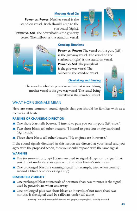
43
Meeting Head-On
Power vs. Power: Neither vessel is the stand-on vessel. Both should keep to the
starboard (right).Power vs. Sail: The powerboat is the give-way
vessel. The sailboat is the stand-on vessel.
Crossing Situations
Power vs. Power: The vessel on the port (left)is the give-way vessel. The vessel on thestarboard (right) is the stand-on vessel.Power vs. Sail: The powerboat is the give-way vessel. The sailboat is the stand-on vessel.
Overtaking and Passing
The vessel — whether power or sail — that is overtaking another vessel is the give-way vessel. The vessel being
overtaken is the stand-on vessel.
WHAT HORN SIGNALS MEAN
Here are some common sound signals that you should be familiar with as a recreational boater:
PASSINg OR CHANgINg DIRECTION
▲One short blast tells boaters, “I intend to pass you on my port (left) side.”
▲Two short blasts tell other boaters, “I intend to pass you on my starboard (right) side.”
▲Three short blasts tell other boaters, “My engines are in reverse.”
If the sound signals discussed in this section are directed at your vessel and you agree with the proposed action, then you should respond with the same signal.
wARNINg
▲Five (or more) short, rapid blasts are used to signal danger or to signal that you do not understand or agree with the other boater’s intentions.
▲One prolonged blast is a warning signal (for example, used when coming around a blind bend or exiting a slip).
RESTRICTED VISIBILITY
▲One prolonged blast at intervals of not more than two minutes is the signal used by powerboats when underway.
▲One prolonged plus two short blasts at intervals of not more than two minutes is the signal used by sailboats under sail alone.
Boating Laws and Responsibilities text and graphics copyright © 2010 by Boat Ed.
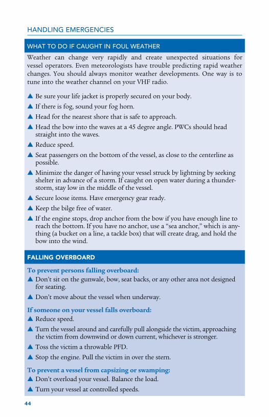
44
HANDLING EMERGENCIES
WHAT TO DO IF CAUGHT IN FOUL WEATHER
Weather can change very rapidly and create unexpected situations for vessel operators. Even meteorologists have trouble predicting rapid weather changes. You should always monitor weather developments. One way is to tune into the weather channel on your VHF radio.
▲Be sure your life jacket is properly secured on your body.
▲If there is fog, sound your fog horn.
▲Head for the nearest shore that is safe to approach.
▲Head the bow into the waves at a 45 degree angle. PWCs should head straight into the waves.
▲Reduce speed.
▲Seat passengers on the bottom of the vessel, as close to the centerline as possible.
▲Minimize the danger of having your vessel struck by lightning by seeking shelter in advance of a storm. If caught on open water during a thunder-storm, stay low in the middle of the vessel.
▲Secure loose items. Have emergency gear ready.
▲Keep the bilge free of water.
▲If the engine stops, drop anchor from the bow if you have enough line to reach the bottom. If you have no anchor, use a “sea anchor,” which is any-thing (a bucket on a line, a tackle box) that will create drag, and hold the bow into the wind.
FALLINg OVERBOARD
To prevent persons falling overboard:▲Don’t sit on the gunwale, bow, seat backs, or any other area not designed
for seating.
▲Don’t move about the vessel when underway.
If someone on your vessel falls overboard:▲Reduce speed.
▲Turn the vessel around and carefully pull alongside the victim, approaching the victim from downwind or down current, whichever is stronger.
▲Toss the victim a throwable PFD.
▲Stop the engine. Pull the victim in over the stern.
To prevent a vessel from capsizing or swamping:▲Don’t overload your vessel. Balance the load.
▲Turn your vessel at controlled speeds.

45
▲Anchor to the bow of the vessel, never to the stern.
▲Don’t boat in rough water or bad weather if you can help it.
If you capsize or swamp your vessel, or if you have fallen out and can’t get back in, stay with the vessel.▲Try to reboard. Or if the vessel is overturned or swamped, hang onto it or
climb onto it. Get as much of your body out of cold water as possible.
If the vessel sinks or floats away, don’t panic.▲If wearing a life jacket, remain calm and await help.
▲If you aren’t wearing a life jacket, look around for one or for other
buoyant items to use as a flotation device.
▲ In cold water, float rather than tread.
UNLAWFUL AND DANGEROUS OPERATION
Massachusetts law states that these dangerous operating practices are also illegal:Reckless or Negligent Operation of a vessel is the failure to exercise the degree of care necessary to prevent the endangering of life, limb, or property of any person. Careful operation includes managing your wake as well as your boat. Your wake is considered a part of your boat, and you are responsible for any injury or damage caused by your wake.
Examples of reckless or negligent operation include:◆ Operating under the influence of alcohol or drugs.
◆ Operating at high speed or erratically in congested waterway traffic.
◆ Operating such that your vessel or another vessel must abruptly swerve or abruptly cut speed in order to avoid a collision.
◆ Operating near or through areas being used by swimmers or divers.
◆ Operating so your vessel collides with another vessel, object, or person.
◆ Cutting through a regatta or marine parade in progress.
◆ Operating between sunset and sunrise without displaying navigation lights.
◆ Chasing or harassing wildlife with your vessel.
Why drinking and boating can be lethalThe effect of alcohol is increased by the natural stressors (wind,
sun, vibration) placed on your body while boating. Alcohol
depresses the central nervous system, affects judgment, and slows
reaction time. Most people become slightly intoxicated after only
one drink. Just remember this simple rule: Don’t drink and boat!
It’s the law!

46
IF A BOATING ACCIDENT HAPPENS…
An operator involved in a boating accident must stop his or her vessel immediately at the scene of the accident in order to:● Assist anyone injured or in danger from the accident, unless doing so would
seriously endanger his or her own vessel or passengers.
● Give, in writing, his or her name, address, and vessel identification to anyone injured and to the owner of any property damaged by the accident.
The operator of a vessel is required to submit a written report to the Massachusetts Environmental Police whenever an accident results in:● The death of a person.
● The disappearance of a person under circumstances that suggest any possibility of death or injury.
● Any injury requiring medical attention.
● Property damage exceeding $500.
Accidents resulting in death or serious injury must be reported to the Mass. Environmental Police within 48 hours. All other accident reports must be submitted within five days. Accidents should be reported on a Boating Accident form available from Mass. Environmental Police, or www.mass.gov/dfwele/dle/boatrvsafe.htm.
HOMELAND SECURITy RESTRICTIONS
Recreational boaters have a role in keeping our waterways safe and secure. Violators of the restrictions below can expect a quick and severe response.● Do not approach within 100 yards, and slow to minimum speed within 500
yards of any U.S. Naval vessel. If you need to pass within 100 yards of a U.S. Naval vessel for safe passage, you must contact the U.S. Naval vessel or the Coast Guard escort vessel on VHF-FM Channel 16.
● Observe and avoid all security zones. Avoid commercial port areas, especially those that involve military, cruise line, or petroleum facilities. Observe and avoid other restricted areas near dams, power plants, etc. Do not stop or anchor beneath bridges or in channels.
● Keep a sharp eye out for anything that looks peculiar or out of the ordinary. Report all suspicious activities to local law enforcement or USCG.
This information is derived from Boat Massachusetts: Your Guide to Boating Laws and Responsibilities under the guidance of Jack Mason, Program Boating Safety Specialist of the Massachusetts Environmental Police (MEP). It is reprinted under a license generously provided by the publisher, Boat Ed. For a complete version of Boat Massachusetts, call 508-759-0002 or visit the website: www.boat-ed.com/ma/handbook.
MEP also provides boaters with boating safety courses that are state and nationally approved and geared to youth and novice boaters of all ages. Call or check the website shown above for courses in your area.

47
PUMPOUTDon’t Dump Out!
S tate and federal laws prohibit dumping untreated sewage into the ocean. The federal Clean Vessel Act (CVA) identifies vessel sewage discharges as “a substantial contributor to localized degradation of water quality in the U.S.” Harbormasters, environmental police officers, and the U.S. Coast Guard all
have the authority to enforce no discharge regulations, including levying fines. Cape Cod Bay is a No Discharge Area (NDA), as are parts of Nantucket Sound.
Vessels have different types of sewage disposal systems. Many people on small boats use portable toilets which can be drained at dump stations. Vessels over 26-feet long typically have Coast Guard-approved Marine Sanitation Devices (MSDs), which are holding tanks that treat sewage with chemical disinfectants. All types of MSDs can and should hold wastes for disposal at a pumpout station. Dumping treated wastes overboard is just as bad for the environment as dumping untreated wastes.
The Massachusetts Division of Marine Fisheries’ administers the state’s CVA Program according to two basic principles: making pumpouts both free and convenient. There are pumpout vessels, shoreside pumpouts, and dump stations all along the coast. Boaters’ enthusiastic support for the CVA program and its goal of cleaner coastal waters has resulted in the removal of over 4,000,000 gallons of effluent since the program started in 1994.
WHAT HAPPENS WHEN yOU DUMP
Vessel sewage can be over 10 times more concentrated than domestic sewage. Dumping human wastes overboard can cause four serious problems for people and the environment: disease, nutrient over- loading, lowered dissolved oxygen levels, and toxicity to marine animals.
Sewage wastes can contain harmful bacteria, viruses, and protozoa. Even small amounts of microorganisms can introduce diseases like hepatitis to people in contact with the water. Bacteria can
2010 No Discharge Areasin Massachusetts
No Discharge Area
Falmouth
BarnstaBle
harwich
chatham
Pleasant Bay(NDA Pending)
wellFleet
caPe codBay
Plymouth, Kingston,duxBury
Buzzards Bay
nantucKet
scituate,marshField,
cohasset
Boston harBor
salem sound

48
also contaminate shellfish beds. Shellfish pump large quantities of water through their bodies during their feeding process and can accumulate high concentrations of microorganisms. Contaminated shellfish can transmit nearly all waterborne pathogens to humans, including hepatitis, typhoid, and cholera.
Plant nutrients such as nitrogen and phosphorous are also components of sewage discharges. They stimulate algae growth. Since there is already too much nitrogen and phosphorus in most of the Sound’s inshore waters, boat wastes can only make the problem worse. Algae blooms caused by excess nutrients smother important eelgrass beds and can use up so much of the dissolved oxygen in the water that they harm marine animals and sometimes even cause fish kills.
Lastly, treated sewage can contain chlorine, formaldehyde, and zinc compounds that are toxic to marine life.
Waste discharges pose the greatest threat in areas where many boats congregate such as at marinas, mooring fields, and raft-up sites. These shallow waters, which are often slow to flush themselves of pollutants, are prime locations for shellfish beds. In addition, dozens of species of fish depend on the Sound’s inshore waters for spawning, larval development, and/or maturation —usually during the peak of the recreational boating season. Many species are at a fraction of their historic levels, in part because of habitat degradation.
To chart a course toward cleaner, healthy coastal waters, we all need to use our heads! And use the pumpouts!
For information regarding the Marine Fisheries CVA Program, please contact Tom Beaulieu, CVA Program Coordinator, at 617-626-1525.
The 2010 Boater’s Guide is supported by a grant from the Massachusetts Clean Vessel Act (CVA) program, which is administered by the Division of Marine Fisheries with funding provided through the U.S. Fish and Wildlife Service’s Sportfish Restoration Program.

49
CHANNEL PHONE

50
CHANNEL PHONE

51

52
MARINASSOUTH SHORE
Town name PhoneDuxbury Bayside Marine Corporation 781-934-0561 Snug Harbor Boat Works 781-934-1366 Long Point Marine, Inc. 781-934-5302Plymouth Brewer’s Plymouth Marine 508-746-4500 Jesse’s Marine 508-746-4500
UPPER CAPE
Town name Phone(508)Bourne Taylor’s Point Marina 759-2512 Kingman Marina 563-7136 Monument Beach Marina 759-3105 Parker’s Boatyard 563-9366Sandwich The Sandwich Marina 833-0808Pocasset Barlow’s Boat Yard 563-3213N. Falmouth Brewer Fiddler’s Cove Marina 564-6327Falmouth East Marine 540-3611 Falmouth Marine Service 548-4600 Falmouth Town Marina 457-2550 MacDougall’s Marine Service 548-3146 Pier 37 540-0123 Quissett Harbor Boatyard 548-0506E. Falmouth Edwards Boatyard 548-2216 Green Pond Marina 457-9283Woods Hole Woods Hole Marina 540-2402Mashpee Mashpee Neck Marina 477-6020 Little River Boatyard 548-3511 New Seabury Marine 477-9197
MID CAPE
Town name Phone(508)Barnstable Barnstable Marine Service 362-3811 Mattakeese Wharf 362-4511 Millway Marina 362-4904Hyannis Hyannis Marina 775-5662Osterville Crosby Yacht Yard 428-6958 Nauticus Marina 428-4537 Oyster Harbors Marine 428-2017S. Yarmouth Ship Shops 398-2256W. Dennis Bass River Marina 394-8341S. Dennis Dennis Municipal Marina 385-5555 Mayfair Boatyard and Marina 398-3722E. Dennis Northside Marina 385-3936

53
MARINASLOwER CAPE
Town name Phone(508)Harwichport Allen Harbor Marine Service 432-0353 Harwichport Boat Yard 432-1322 Saquatucket Harbor 430-7532Chatham Chatham Yacht Basin 945-0728 Outermost Harbor Marine 945-2030 Oyster River Boat Yard 945-0736 Pease Boat Works & Marine Railway 945-7800 Stage Harbor Marine 945-1860 Ryder’s Cove Boatyard 945-1064Orleans Arey’s Pond Boat Yard 255-0994 Nauset Marine-Marina East 255-3045 Rock Harbor Municipal Marina 240-5972Wellfleet Wellfleet Marine 349-2233Provincetown Flyers Boat Shop, Inc. 487-0518 Provincetown Public Pier Corp. 487-7030 Provincetown Yacht Marina 487-8899
MARTHA’S VINEYARD
Town name Phone(508)Vineyard Haven Coastwise Wharf Co. 693-3854 Gannon & Benjamin Marine Railway 693-4658 Maciel Marine Ltd. 693-4174 Tisbury Wharf Co. 693-9300 Vineyard Haven Marina 693-0720Oak Bluffs Dockside Marketplace & Marina 693-3392 Oak Bluffs Marina 693-4355Edgartown Mad Max Marina 627-7400
NANTUCKET
Town name Phone(508)Nantucket Grey Lady Marine 228-6525 Madaket Marine 228-1163 Nantucket Boat Basin 325-1350 Nantucket Moorings 228-4472

54
KEY CONTACT NUMBERSIn an emergency, you can always call 911 to get a message to a harbormaster, police and fire departments, and the Coast Guard.
U.S. Coast guard: VHF Channel 16, the international distress, safety and calling channel or these local numbers: Station Point Allerton 781-925-0165—South Shore to the Plymouth Power Plant Station Cape Cod Canal 508-888-0020—the Canal to Eastham Station Provincetown 508-487-0077—Wellfleet to Provincetown Station Woods Hole 508-457-3214—Vineyard and Nantucket Sounds Station Chatham 508-945-3829—off-Chatham, Pleasant Bay
Massachusetts Environmental Police: 800-632-8075
Mass. Division of Marine Fisheries: Boston 617-626-1520; V. Haven 508-693-4372
Nantucket Soundkeeper: 508-945-2432
To report an oil spill or slick call the Mass. Dept. of Environmental Protection 888-304-1133
To report an injured or stranded whale, dolphin, or seal call the Stranding Hotline 508-743-9548.
To report entangled whales, call the Atlantic Large Whale Disentanglement Network Hotline at 800-900-3622, or notify the USCG on VHF Channel 16.
To report sightings of live right whales call the NMFS Sighting Advisory System at 978-585-8473 or notify the USCG on VHF Channel 16.

55
HARBORMASTERSTown name Phone hailingChannel workingChannel
Aquinnah Brian Vanderhoop 508-645-2307 16 66, 68
Barnstable Dan Horn 508-790-6272 16 68
Bourne Tim Mullin 508-759-0261 ext. 321 09, 16 08, 10
Brewster Chris Miller 508-896-4546
Chatham Stuart F. X. Smith 508-945-5185 16 66
Chilmark Dennis Jason 508-645-2846 9 69
Dennis Terry Clen 508-385-5555 16 66
Duxbury Donald E. Beers III 781-934-2866 16 12
Eastham Mike O’Connor 508-240-5972 16 16
Edgartown Charles J. Blair, Jr. 508-627-4746 9, 74 74 508-627-6185
Falmouth Gregg P. Fraser 508-457-2550 09, 16 12 508-457-2551
Harwich Thomas E. Leach 508-430-7532 68, 16 68, 66
Kingston Dennis M. Carvalho 781-585- 0519 06 06
Mashpee Perry Ellis 508-539-1450 09, 16 68, 66
Nantucket David Fronzuto 508-228-7261 9, 14 14
Oak Bluffs Todd Alexander 508- 693-4355 71 71
Orleans Dawson L. Farber IV 508-240-3755 16 66
Plymouth Chad Hunter 508-830-4182 16 16
Provincetown Rex McKinsey 508-487-7030 09, 16 12, 16
Sandwich Greg Fayne 508-833-0808 09 68, 66
Tisbury John Wilbur III 508-696-4249 9 69 508-696-4201
Truro Joseph Francis 508-349-2555 09, 16 68, 66
Wellfleet Mike Flanagan 508-349-0320 09, 16 68, 66
Yarmouth Karl von Hone 508-760-4800 09, 16 68, 66

56
Tow BoAT SeRvIceS from Boston to Block Island
You should check with the towing operator about the terms and conditions of his services before engaging him.
TOwBOATU.S.To contact a towing company, call the number listed here, or the 24-hour dispatch line: 800-391-4869, or Channel 16 on your VHF radio. TowBoatU.S. companies provide towing up to 25 miles from their homeport, unless an extended service area is specified.
TowBoatU.S. Boston25 Miles OffshoreQuincy, MA978-465-8876
TowBoatU.S. South Shore35 Miles Offshore Marshfield, MA781-837-2322
TowBoatU.S. Northcape30 Miles Offshore Harwich Port, MA 508-776-5712
TowBoatU.S. Cape Cod50 Miles Offshore Onset, MA 508-295-2226
TowBoatU.S. Falmouth100 Miles Offshore West Barnstable, MA508-362-3040
TowBoatU.S. Bass River40 Miles Offshore Bass River, MA508-364-6674
TowBoatU.S. Nantucket Island25 Miles OffshoreNantucket, MA508-257-9625
TowBoatU.S. New BedfordDartmouth, MA 508-990-3997
TowBoatU.S. westport25 Miles Offshore Westport, MA508-990-3997
TowBoatU.S.Narragansett BayWickford, RI 401-295-8711
TowBoatU.S. Point JudithPoint Judith, RI 401-295-8711
TowBoatU.S. Block IslandBlock Island, RI401-295-8711
SEA TOwTo contact a towing company, call the number listed here or Channel 16 on your VHF radio. Sea Tow companies provide towing up to 40 miles from their homeport.
Sea Tow Boston617-567-8053
Sea Tow South Shore Green Harbor 781-834-5242
Sea Tow Cape and IslandsCataumet508-564-9555

