2008 gbcma boating guide 12pp - gbcma.vic.gov.au · safe boating the goulburn river waterway...
TRANSCRIPT
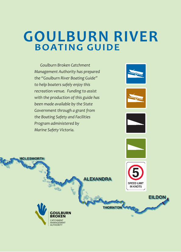
Goulburn riverboatinG Guide
Goulburn Broken Catchment Management Authority has prepared the “Goulburn River Boating Guide” to help boaters safely enjoy this recreation venue. Funding to assist with the production of this guide has been made available by the State Government through a grant from the Boating Safety and Facilities Program administered byMarine Safety Victoria.

the WaterWayGoulburn Broken Catchment Management Authority is the waterway manager
appointed under the Marine Act 1988 for the Goulburn River between the Lake Eildon Pondage and Hughes Creek, excluding creeks and streams flowing into the river and storages. This represents a distance of approximately 165 km, much of it isolated.
the boatinG GuideBoat operators should recognise that water flow and depths vary during the year,
often at very short notice. They should exercise care to ensure that they are operating in a safe fashion appropriate to their location and not adversely impacting on other water users and the environment. The guide is intended to provide information to raise the level of boating safety awareness before people venture onto the river to enjoy the boating experience.
The Goulburn River offers a diverse boating and recreational activity environment that attracts people to enjoy fishing, canoeing/kayaking and rafting. The major source of water is Lake Eildon and these waters are used for irrigation in northern Victoria, with the balance flowing into the Murray River. The varying demand for irrigation is one of the reasons for periodic changes to the river that may impact on boating.
The Statewide operating rules made under the provisions of the Marine Act 1988 apply to the whole of the Goulburn River between the Eildon Pondage and Hughes Creek (downstream from Seymour).
All operators of powered and un-powered boats must understand the commonsense boating safety rules before venturing onto the Goulburn River and in particular be aware of the specific boating conditions along the river.
2
Safe boatinGThe Goulburn River waterway environment offers a range of boating opportunities.
However, it is important that boat operators recognise some of the operational limitations that may influence boating safety, including:
Water flow and depth could change unexpectedly.
Overhanging trees often can limit navigation – particularly willow trees
Shallow water and sub-surface obstructions are common along the whole water course so a good lookout must be kept
Other boats could be encountered when turning bends in the river – particularly canoeing and rafting groups.
Much of the river is isolated and away from towns and roads so boaters should always tell someone where they intend to go boating and when they expect to return.
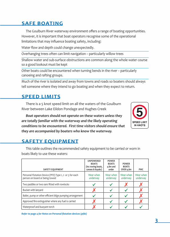
Speed limitSThere is a 5 knot speed limit on all the waters of the Goulburn
River between Lake Eildon Pondage and Hughes Creek
Boat operators should not operate on these waters unless they are totally familiar with the waterway and the likely operating conditions to be encountered. First time visitors should ensure that they are accompanied by boaters who know the waterway.
Safety equipmentThis table outlines the recommended safety equipment to be carried or worn in
boats likely to use these waters:
Safety equipment
unpoWeredboatS
(inc rowing boats, canoes & kayaks)
poWer boatS
4.8m and under
poWer boatS
over 4.8m pWC
Personal Flotation Device (PFD) Type 1, 2 or 3 for each person on board or being towed
Wear when underway
Wear whenunderway
Wear whenunderway
Wear when underway
Two paddles or two oars fitted with rowlocks [ [ 7 7Bucket with lanyard 7 [ [ 7Bailer, pump or other efficient bilge pumping arrangement [ [ [ 7Approved fire extinguisher where any fuel is carried 7 [ [ 7Waterproof and buoyant torch 7 [ [ [
Refer to page 4 for Notes on Personal flotation devices (pfds)
3
Safety equipment Continued
Notes on Personal flotation devices (pfds)
All pfds must be approved in accordance with the Marine Act 1988.
All persons in a boat 4.8m or under are required to wear a PFD whenever the boat is underway - “Underway” means not at anchor, made fast to the shore, or aground. If drifting you are under way. Vessels travelling at any speed are at risk of being involved in an incident where the occupants suddenly and unexpectedly enter the water. Marine Safety Victoria data shows that nationally, 17% of fatalities occurred whilst the vessel was drifting or at slow speed.
All persons operating a boat alone must wear a pfd.
All children under the age of 10 years must wear a PFD at all times.
Also cArry >> EPIRB - while not required on these waters, consideration should be given to carrying an emergency beacon.
>> Emergency sheet – to make you more visible.
>> First aid kit - to treat minor injuries.
0.05 alCohol limitSAll boat operators must observe the 0.05 blood alcohol limits and
operators under 21 years of age must observe a zero blood alcohol limit. Severe penalties apply for exceeding the limit.
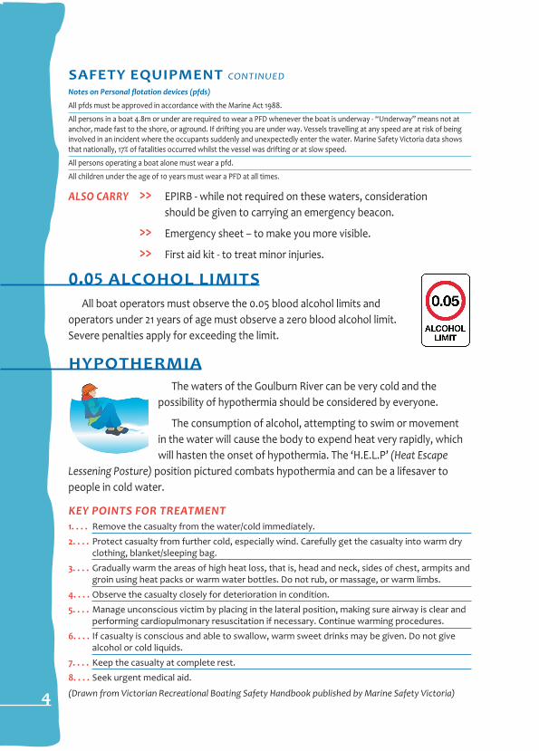
hypothermiaThe waters of the Goulburn River can be very cold and the
possibility of hypothermia should be considered by everyone.
The consumption of alcohol, attempting to swim or movement in the water will cause the body to expend heat very rapidly, which will hasten the onset of hypothermia. The ‘H.E.L.P’ (Heat escape
Lessening Posture) position pictured combats hypothermia and can be a lifesaver to people in cold water.
Key Points For treAtment1. . . . Remove the casualty from the water/cold immediately.
2. . . . Protect casualty from further cold, especially wind. Carefully get the casualty into warm dry clothing, blanket/sleeping bag.
3. . . . Gradually warm the areas of high heat loss, that is, head and neck, sides of chest, armpits and groin using heat packs or warm water bottles. Do not rub, or massage, or warm limbs.
4. . . . Observe the casualty closely for deterioration in condition.
5. . . . Manage unconscious victim by placing in the lateral position, making sure airway is clear and performing cardiopulmonary resuscitation if necessary. Continue warming procedures.
6. . . . If casualty is conscious and able to swallow, warm sweet drinks may be given. Do not give alcohol or cold liquids.
7. . . . Keep the casualty at complete rest.
8. . . . Seek urgent medical aid.
(drawn from Victorian Recreational Boating Safety Handbook published by Marine Safety Victoria)4
1
2
3
4
5
6
7
8
9
10
11
12
A B C D E F G H
A B C D E F G H
1
2
3
4
5
6
7
8
9
10
11
12
UPPER GOULBURN RD
HUGHES CR EEK
GOULBURN VALLEY HWY
HUME F
WY
SEYMOUR TOOBORAC
ANZAC AVE
SEYMOUR
GOULBURN VALLEY HWY
TRAWOOL
GOULBURN VALLEY HWY
KI
T
NR
G C
PAR
O
K
REEF
LIONS PARKSEYMOUR
GOULBURN VALLEY HWYTRAWOOL BRIDGE
KERRISDALEROADSIDE STOP
6.5 km to Mitchelton24km to Lake Nagambie
18
7
19
2
2
HUME
FWY
HORSESHOELAGOON
PRIVATEBRIDGE
16
GE
O
RE
NSL
PE
S RD
N
GARD
NERS
LN
RD
GARDNERSLANE
TALLAROOK
Kerrisdale
GOULBURN RIVER PARKSEYMOUR
EILDON
ALEXANDRA
SEYMOUR
TRAWOOL
MOLESWORTH
THORNTON
HUGHES CREEK
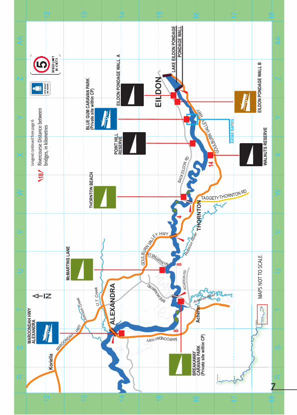
LEGEND
Concrete ramps
Gravel ramps
Unformed river bank crossings for small boats
Rubber matting for canoes, kayaks, rafts and small boats that can belifted into the water.
Rivercourse Distance between bridges, in kilometres
18
MAPS NOT TO SCALE. 5

MN
OP
QR
IJ
KL
MN
OP
QR
IJ
KL
W
RH
EAN
RGA
RWE
N
D
G
A
O
VU
L
RNBU
LLEY
HW
Y
MAROO
Y
NDA HH
W
Wha
nreg
arwe
n
GOULBU RLL
NA V
EY HWY
GHIN HGIN RD
YE
A
KILLINGT WORH RDK
WIL L
INO
GRT
H R
D
MA
A
ROOND
H HWYRIDDS RD
Kill
ingw
orth
Caith
kin
MELBA HWY
WHITTLE
SEA -
YEA R
D
Yea R
iver
GHNI GHIN RD
13
FULL
ERTO
N
RD
31
SWR
ITZE
LAND
RD
MO
LE
SW
OR
TH
OLD
BRID
GE
6
G
O
H
ULBU
RV N
W
ALLE
Y Y
N GHIN
GHI
N RE
SERV
E
KILL
INGW
ORTH
RIVE
R RE
SERV
E
MOLE
SWOR
TH
RECR
EATI
ONRE
SERV
E
9 10 11 13 14 1512
RIDD
S RO
AD
9 10 11 13 14 1512
6
EIL
DO
N
AL
EX
AN
DR
A
SE
YM
OU
R
TRAW
OO
L
MO
LESW
OR
TH
THO
RN
TON
HU
GH
ES C
REE
K
MAP
S N
OT
TO S
CALE
.
LEG
END
Conc
rete
ram
ps
Gra
vel r
amps
Unf
orm
ed ri
ver b
ank
cros
sings
for
smal
l boa
ts
Rubb
er m
attin
g fo
r can
oes,
kaya
ks,
rafts
and
smal
l boa
ts th
at c
an b
elif
ted
into
the
wat
er
Leng
end
cont
inue
d on
pag
e 7
ST
UV
WX
YZ
AARR
ST
UV
WX
YZ
AA
GOUL
BURN
VL
AL
EY HWY
Acheron River
MW AD ROONAH HY
Korie
lla
BREAW
KA
AY RD
McMARTINS LN
TH
OR
NT
ON
TAGGETY TOH TO NR N RD
BACK
EILD
ONRD
EIL
DO
N
Rubi
con
Rive
r
AL
EX
AN
DR
A ACHE
RON
RD
MAROONDAH HW
Y
KAYA
K RA
PIDS
THOR
NTON
BEA
CH
WAL
NUTS
RES
ERVE
EILD
ON P
ONDA
GE W
ALL
B
EILD
ON P
ONDA
GE W
ALL
A
LAKE
EIL
DON
POND
AGE
POND
AGE
WAL
L8
84
14
U.T
. Cre
ek
John
son
Cree
kN
Ache
ron
GOUL
BURN
VALL
EY
HWY
MARO
ONDA
H HW
YAL
EXAN
DRA
McMA
RTIN
S LA
NE
BLUE
GUM
CAR
AVAN
PAR
K(P
rivat
e site
with
in C
P)
BREA
KAW
AYCA
RAVA
N PA
RK(P
rivat
e site
with
in C
P)
POIN
T HI
LLRE
SERV
E
13 14 15 16 17 1812
13 14 15 16 17 1812
7
EIL
DO
N
AL
EX
AN
DR
A
SE
YM
OU
R
TRAW
OO
L
MO
LESW
OR
TH
THO
RN
TON
HU
GH
ES C
REE
K
MAP
S N
OT
TO S
CALE
.
18Le
ngen
d co
ntin
ued
from
pag
e 6
Rive
rcou
rse
Dist
ance
bet
wee
n br
idge
s, in
kilo
met
res
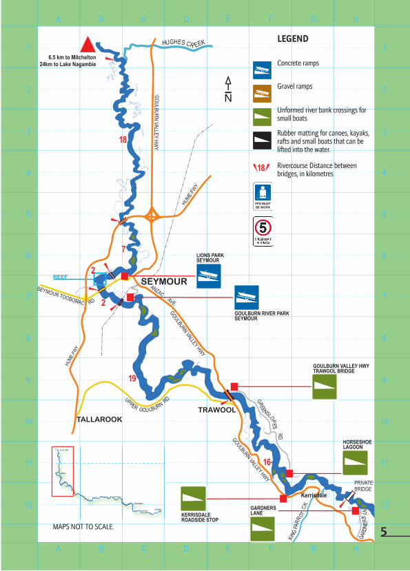
WaterWay aCCeSSThere are approximately 165 kms of river available for various types of boating
activities and there are public access points along the river available for different types of boats.
Concrete ramps
Gravel ramps
Unformed river bank crossings for small boats
Rubber matting for canoes, kayaks, rafts and small boats that can be lifted into the water – these ramps should not be used to launch boats from trailers
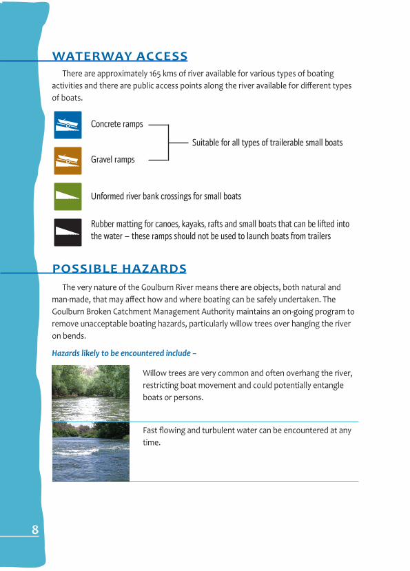
poSSible hazardSThe very nature of the Goulburn River means there are objects, both natural and
man-made, that may affect how and where boating can be safely undertaken. The Goulburn Broken Catchment Management Authority maintains an on-going program to remove unacceptable boating hazards, particularly willow trees over hanging the river on bends.
Hazards likely to be encountered include –
Willow trees are very common and often overhang the river, restricting boat movement and could potentially entangle boats or persons.
Fast flowing and turbulent water can be encountered at any time.
8
Suitable for all types of trailerable small boats

9
poSSible hazardS Continued
Above water snags creates barriers across all or part of the river.
Man made objects can restrict boat movement, including rocks placed in river for white water activity and fish habitat, pumps, water outfalls, jetties and bridges.
Closure for special events - major canoeing and kayaking events are held on the river adjacent to the Blue Gums Caravan Park. Special rules may be introduced during events if it is necessary to keep other users away. Arrangements will be in place to ensure that other users are given supervised passage through the area. Any temporary changes are advertised and signs erected.
Be prepared - boaters should also be prepared to encounter other boats, particularly large recreation rafting and canoeing groups.
Below water snags such as tree stumps or rocks are common and must be expected.
Sharp river bends restrict sight distance and mean that other boats and people may be encountered unexpectedly. Bends can alter river flow direction and speed.
Shallow water may restrict movement, often requiring boats to be dragged over the river bed – suitable footwear should be carried.
boatinG environment & touriSmrespect private property
Much of the land adjacent to the waterway is private property or leased Crown Land and the permission of the land owner should be obtained before entering private property.
Protect the environment
The waters and adjacent land are part of a sensitive environment and boaters should undertake their recreation activity in such a way as to help protect and maintain this resource.
Keep your rubbish on board and dispose of it when you return to shore.
Do not pollute the water or the adjacent land – and take special care not to spill any fuel – pollution is not only illegal, it destroys the environment that makes this waterway so popular.
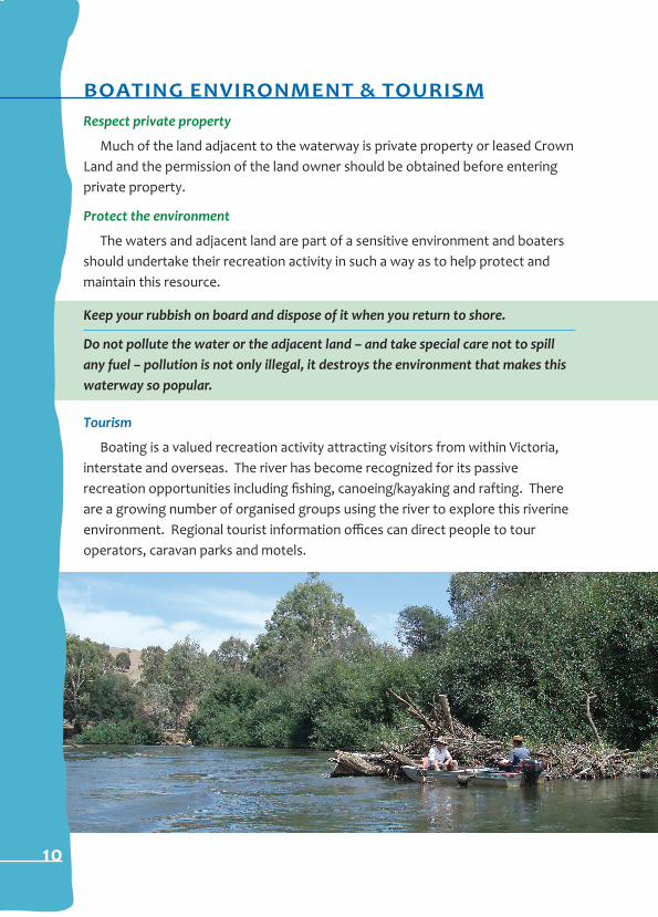
tourism
Boating is a valued recreation activity attracting visitors from within Victoria, interstate and overseas. The river has become recognized for its passive recreation opportunities including fishing, canoeing/kayaking and rafting. There are a growing number of organised groups using the river to explore this riverine environment. Regional tourist information offices can direct people to tour operators, caravan parks and motels.
10
boat reGiStration andoperator liCenSinGBoat registration
All boats equipped with a motor capable of being used for propulsion are re-quired to be registered with Marine Safety Victoria through its agent VicRoads.
operator licensing
All recreational power boat operators are required to hold an operator’s licence issued by Marine Safety Victoria through its agent VicRoads.
licensing requirements –
Under 12 years Not permitted to operate a power boat12 to less than 16 years Restricted Power Boat Operator Licence - Subject to speed limits, operating hours and supervision requirements16 years and over General Power Boat Operator Licence
for General WaterWay enquireS ContaCtGoulburn Broken Catchment Management Authority (boating rules & activity) - Yea Office (03) 5736 0100
related internet sites
Goulburn Broken Catchment Management Authority (GBCMA) www.gbcma.vic.gov.auMarine Safety Victoria www.marinesafety.vic.gov.au
Goulburn Murray Water www.g-mwater.com.au
VicRoads www.vicroads.vic.gov.au
Weather Bureau www.bom.gov.au
11
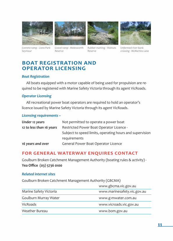
Conrete ramp - Lions Park Seymour
Gravel ramp - Molesworth Reserve
Rubber matting - Walnuts Reserve
unformed river bank crossing - McMartins Lane
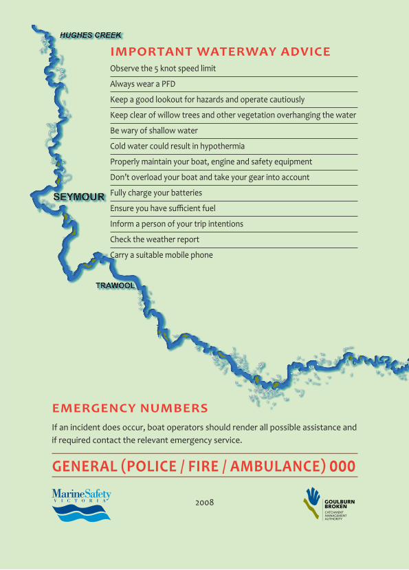
important WaterWay adviCeObserve the 5 knot speed limit
Always wear a PFD
Keep a good lookout for hazards and operate cautiously
Keep clear of willow trees and other vegetation overhanging the water
Be wary of shallow water
Cold water could result in hypothermia
Properly maintain your boat, engine and safety equipment
Don’t overload your boat and take your gear into account
Fully charge your batteries
Ensure you have sufficient fuel
Inform a person of your trip intentions
Check the weather report
Carry a suitable mobile phone
emerGenCy numberSIf an incident does occur, boat operators should render all possible assistance and if required contact the relevant emergency service.
General (POlice / Fire / ambulance) 000
2008