2002 activities of the central great lakes binational …...sandusky fisheries research station 305...
TRANSCRIPT
Presented at: Great Lakes Fishery Commission Upper Lakes Committee Meetings, Ypsilanti, MI, March 22-25, 2004 Lower Lakes Committee Meetings, Grand Island, NY, March 30-April 1, 2004 Provisional data, do not site without authors permission.
2002 Activities of the Central Great Lakes Binational Lake Sturgeon Group
Editors: Tracy D. Hill and Jerry R. McClain U.S. Fish and Wildlife Service Alpena Fishery Resources Office Federal Building Room 204 145 Water St. Alpena, MI 49707 (989) 356-5102, (989) 356-4651 Fax [email protected]
CONTRIBUTORS Roger Bergstedt (Lake Huron) U.S. Geological Survey Hammond Bay Biological Station 11188 Ray Road Millersburg, MI 49759-9481 (989) 734-4768, (989) 734-4494 Fax Email: [email protected] James Boase (St. Clair Waterway) U.S. Fish and Wildlife Service Alpena Fishery Resources Office Federal Building Room 204 145 Water St. Alpena, MI 49707 (248) 894-7594, (989) 356-4651 Fax Email: [email protected] Konrad Dabrowski (St. Clair Waterway) The Ohio State University School of Natural Resources 2021 Coffey Rd. Columbus, OH 43210 (614)292-4555, (614)192-7435 Fax Email: [email protected]
Julia Froschauer (St. Clair Waterway) The Ohio State University School of Natural Resources 2021 Coffey Rd. Columbus, OH 43210 (614)292-4555, (614)192-7435 Fax Email: [email protected] Roger Greil (St. Marys River) Lake Superior State University Aquatic Research Lab 625 Easterday Ave. Sault Ste. Marie, MI 49783 (906) 635-1949, (906) 635-0214 Fax Email: [email protected] Adam Kowalski (Lake Huron) U.S. Fish and Wildlife Service Alpena Fishery Resources Office Federal Building Room 204 145 Water St. Alpena, MI 49707 (989) 356-5102, (989) 356-4651 Fax Email: [email protected]

ii
Bruce Manny (St. Clair Waterway) U.S. Geological Survey Great Lakes Science Center 1451 Green Road Ann Arbor, MI 48105 (734) 214-7255, (734) 994-8780 Fax Email: [email protected] Lloyd C Mohr (Lake Huron) Ontario Ministry of Natural Resources Upper Great Lakes Management Unit – Lake Huron Office 1450 Seventh Avenue East Owen Sound, ONT N4K 2Z1 (519) 371-5669, (519) 371-5844 Fax Email: [email protected] Henry Quinlan (Lake Huron) U.S. Fish and Wildlife Service Ashland Fishery Resources Office 2800 Lake Shore Dr. E. Ashland, WI 54806 (715) 682-6185, (715) 682-8899 Fax Email: [email protected] Rich Quintal (St. Clair Waterway) U.S. Geological Survey Great Lakes Science Center 1451 Green Road Ann Arbor, MI 48105 (734) 214-9319, (734) 994-8780 Fax Email: [email protected] Trent Sutton (St. Marys) Purdue University Forestry and Natural Resources 195 Marsteller St. West Lafayette, IN 47907-1159 (765) 496-6266, (765) 496-2422 Fax Email: [email protected]
Michael V. Thomas (St. Clair Waterway) Michigan Dept. of Natural Resources Mt. Clemens Fisheries Research Station 33135 South River Road Mt. Clemens, MI 48045 (586) 465-4771, (586) 465-7504 Fax e-mail: [email protected] Chris Vandergoot (Lake Erie) Ohio Department of Natural Resources Sandusky Fisheries Research Station 305 East Shoreline Drive Sandusky, OH 44870 (419) 625-8062, (419) 625-6272 Fax Email: [email protected] Jerry Weise (Lake Huron) Fisheries and Oceans Canada Sea Lamprey Control Center 1 Canal Drive Sault Ste. Marie, ON P6A 6W4 (705) 941-3006, (705) 941-3025 Fax Email: [email protected] John Weisser (Lake Huron) U.S. Fish and Wildlife Service Marquette Biological Station 1924 Industrial Parkway Marquette, MI 49855-1699 (906) 226-1213, (906) 226-3632 Fax Email: [email protected] Emily C. Zollweg (Niagara River) U.S. Fish and Wildlife Service Lower Great Lakes Fishery Resources Office 405 N. French Road, Suite 120A Amherst, NY 14228 (716) 691-5456, (716) 691-6154 Fax Email: [email protected]
iii
CONTRIBUTORS.......................................................................................................... i PREFACE ....................................................................................................................... iv ST. MARYS .................................................................................................................... 1
Lake Superior State University Aquatic Research Lab .................................................. 1 LAKE HURON............................................................................................................. 16
Ontario Ministry of Natural Resources Lake Huron Management Unit....................... 16 U.S. Fish and Wildlife Service Alpena Fishery Resources Office ............................... 21 U.S. Fish and Wildlife Service Marquette Biological Station ...................................... 28 Fisheries and Oceans Canada Sea Lamprey Control Center ........................................ 28 U.S. Fish and Wildlife Service Ashland Fishery Resources Office ............................. 31 U.S. Geological Survey Hammond Bay Biological Station ......................................... 31
ST. CLAIR WATERWAY ......................................................................................... 33
Michigan Department of Natural Resources Mt. Clemens Fisheries Research Station 33 U.S. Fish and Wildlife Service Alpena Fishery Resources Office ............................... 38 U.S. Geological Survey Great Lakes Science Center ................................................... 45 U.S. Geological Survey Great Lakes Science Center ................................................... 47 The Ohio State University School of Natural Resources.............................................. 52
LAKE ERIE................................................................................................................... 55
Ohio Division of Wildlife Sandusky Fisheries Research Station ................................. 55 NIAGARA RIVER....................................................................................................... 56
U.S. Fish and Wildlife Service Lower Great Lakes Fishery Resources Office............ 56

iv
PREFACE
In 1995, resource personnel from federal, state, and provincial agencies agreed to a collaborative effort to better define the population status of lake sturgeon in Lakes Huron and Erie and their connecting waterways. These efforts resulted in the creation of the Central Great Lakes Bi-National Lake Sturgeon Group (CGLBLSG). The U.S. Fish & Wildlife Service Alpena FRO has agreed to compile an annual report summarizing activities of agencies and organizations participating in the CGLBLSG. Following is a summary of 2002 activities. This report details information on 952 lake sturgeon encountered during the 2002 field season. A total of 85 lake sturgeon that were handled during 2002 were tagged in previous years. The total number of lake sturgeon tagged in the central Great Lakes is approaching 5,500 fish. Previous years’ reports for this group can be found on the Alpena FRO home page (http://midwest.fws.gov/alpena/index.htm) under “Reports”.
The increased level of cooperation within this group has led to several notable results. First, with increased participation by commercial fishers, both Canadian and US, information recorded from lake sturgeon by-catch and harvest has been used to describe the life history and relative health and sustainability of lake sturgeon stocks throughout the central Great Lakes basin. Investigations are now underway to identify and quantify current spawning use at historic spawning sites, areas identified through new research, and creation of new spawning areas. Using emerging technologies we are investigating habitat use and identifying critical habitat that will be essential for the recovery and sustainability of this species. Emerging technologies have also allowed for the development of a non-lethal contaminant sampling procedure for lake sturgeon. Cooperation between Sea Lamprey Control agents, the Michigan Department of Natural Resources (MDNR) and Ontario Ministry of Natural Resources (OMNR) resulted in treatment of 11 streams in Michigan and Canada containing both sea lamprey and lake sturgeon in 2002.
In the years ahead, investigations are planned to identify juvenile lake sturgeon habitat and assess status of this life stage, genetic data will be used to identify spawning stocks and level of mixing throughout the central Great Lakes, a tributary inventory is planned to locate more spawning sites and populations, and contaminants investigations will continue.
1
ST. MARYS
Lake Superior State University Aquatic Research Lab Contact: Roger Greil and Trent Sutton E-mail: [email protected] [email protected]
Assessment of Lake Sturgeon in the St. Marys River 2002
Background The St. Marys River, the largest tributary to Lake Huron, supports a large number of fish species (Draft Environmental Impact Statement, U.S. Army Corp of Engineers 1993; Bray 1996). Among these fishes is the lake sturgeon (Acipenser fulvescens), a threatened species in Michigan (http://www.michigan.gov/dnr) which little is known about in the St Marys River. Historically, the St Marys River Rapids were one of the most productive habitats for fish and lake sturgeon were one of the most abundant fish in that system (CHRS 2002). In the 1960s, the population of lake sturgeon appeared to be large enough to support a commercial fishery in the lower reaches of the river (i.e. Georgian Bay and the North Channel; Bernier 1972). Changes in the flow regime of the rapids began in 1921 with completion of the compensating works above the rapids (Bray 1995). With the development of hydropower generating facilities, navigation locks, and flow control structures, the surface area of the rapids has been reduced by 50% and about 93% of the total flow has been diverted (Edsall 1993). With the dewatering of the rapids and the dredging of the river channel, winter navigation, and subsequent habitat changes, it is unclear what affects these changes would have on the St. Marys lake sturgeon population. Anglers have reported catching and seeing congregations of lake sturgeon at different locations of the river during late spring or early summer that were possibly exhibiting spawning behaviors. Lake sturgeon were reported near the Edison Sault Hydroelectric Plant power cannel, the mouth of Lake George, and just above Munuscong Bay. Lake sturgeon spawn at water depths ranging from 0.6 to 5 m in areas of swift water with rocky substrate (Scott 1973)and the sturgeon sightings have been in areas of the river that exhibit these characteristics. If these sites are being utilized by lake sturgeon for spawning,it becomes essential that efforts be undertaken to protect them in light of the habitat alterations at the rapids. Current population status and structure, recruitment, and habitat use of the St. Marys River by lake sturgeon remains unknown. In 1995, the Michigan Department of Natural Resources (MDNR) sampled the entire St. Marys River to determine the status of the fish community and to assess changes in the fish community since surveys were conducted in 1975, 1979, and 1987 (Fielder 1998). Lake sturgeon were absent from the 1995 survey (sturgeon were present in earlier surveys). Lake Superior State University Aquatic Research Laboratory (ARL) personnel began surveying
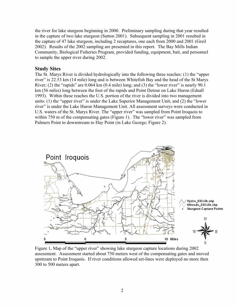
2
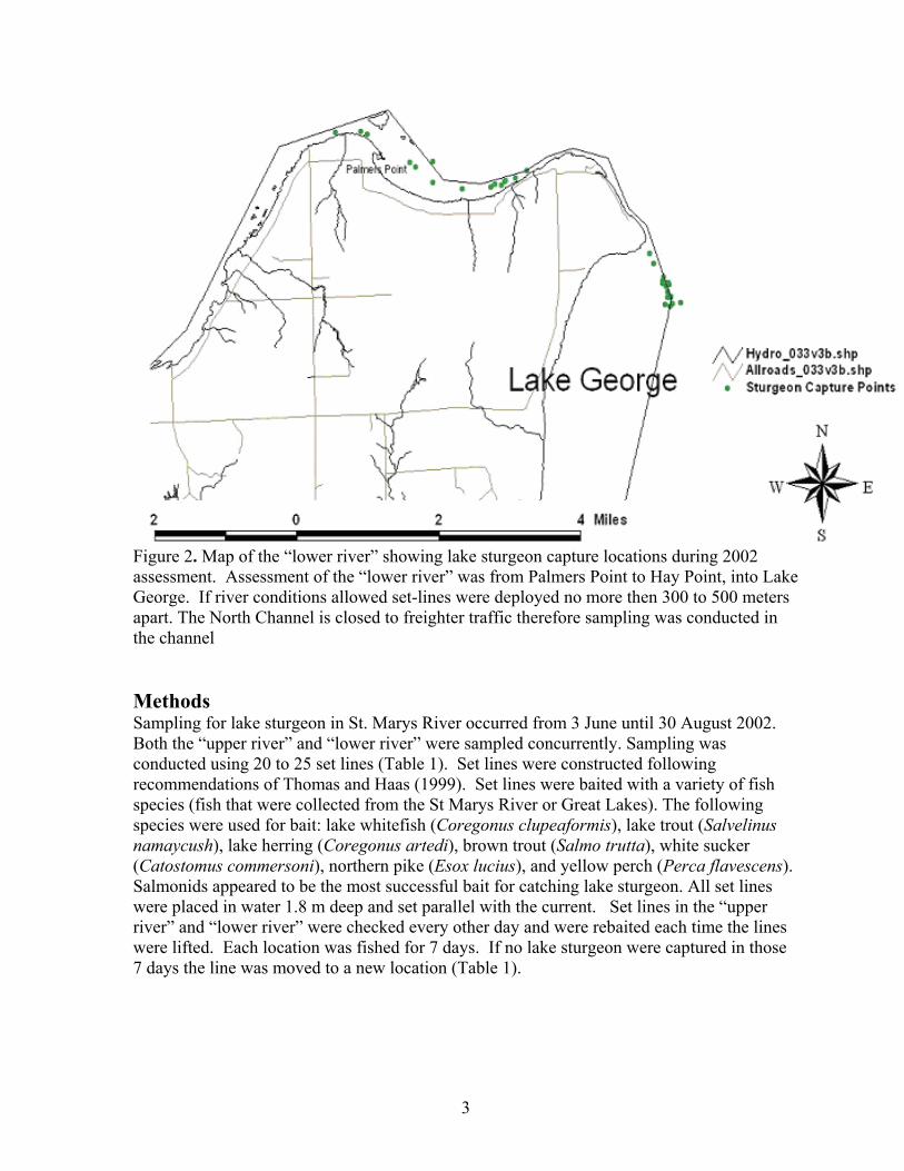
the river for lake sturgeon beginning in 2000. Preliminary sampling during that year resulted in the capture of two lake sturgeon (Sutton 2001). Subsequent sampling in 2001 resulted in the capture of 47 lake sturgeon, including 2 recaptures, one each from 2000 and 2001 (Greil 2002). Results of the 2002 sampling are presented in this report. The Bay Mills Indian Community, Biological Fisheries Program, provided funding, equipment, bait, and personnel to sample the upper river during 2002. Study Sites The St. Marys River is divided hydrologically into the following three reaches: (1) the “upper river” is 22.53 km (14 mile) long and is between Whitefish Bay and the head of the St Marys River; (2) the “rapids” are 0.064 km (0.4 mile) long; and (3) the “lower river” is nearly 90.1 km (56 miles) long between the foot of the rapids and Point Detour on Lake Huron (Edsall 1993). Within these reaches the U.S. portion of the river is divided into two management units: (1) the “upper river” is under the Lake Superior Management Unit; and (2) the “lower river” is under the Lake Huron Management Unit. All assessment surveys were conducted in U.S. waters of the St. Marys River. The “upper river” was sampled from Point Iroquois to within 750 m of the compensating gates (Figure 1). The “lower river” was sampled from Palmers Point to downstream to Hay Point (in Lake George; Figure 2).
Figure 1. Map of the “upper river” showing lake sturgeon capture locations during 2002 assessment. Assessment started about 750 meters west of the compensating gates and moved upstream to Point Iroquois. If river conditions allowed set-lines were deployed no more then 300 to 500 meters apart.
3
Figure 2. Map of the “lower river” showing lake sturgeon capture locations during 2002 assessment. Assessment of the “lower river” was from Palmers Point to Hay Point, into Lake George. If river conditions allowed set-lines were deployed no more then 300 to 500 meters apart. The North Channel is closed to freighter traffic therefore sampling was conducted in the channel Methods Sampling for lake sturgeon in St. Marys River occurred from 3 June until 30 August 2002. Both the “upper river” and “lower river” were sampled concurrently. Sampling was conducted using 20 to 25 set lines (Table 1). Set lines were constructed following recommendations of Thomas and Haas (1999). Set lines were baited with a variety of fish species (fish that were collected from the St Marys River or Great Lakes). The following species were used for bait: lake whitefish (Coregonus clupeaformis), lake trout (Salvelinus namaycush), lake herring (Coregonus artedi), brown trout (Salmo trutta), white sucker (Catostomus commersoni), northern pike (Esox lucius), and yellow perch (Perca flavescens). Salmonids appeared to be the most successful bait for catching lake sturgeon. All set lines were placed in water 1.8 m deep and set parallel with the current. Set lines in the “upper river” and “lower river” were checked every other day and were rebaited each time the lines were lifted. Each location was fished for 7 days. If no lake sturgeon were captured in those 7 days the line was moved to a new location (Table 1).
4
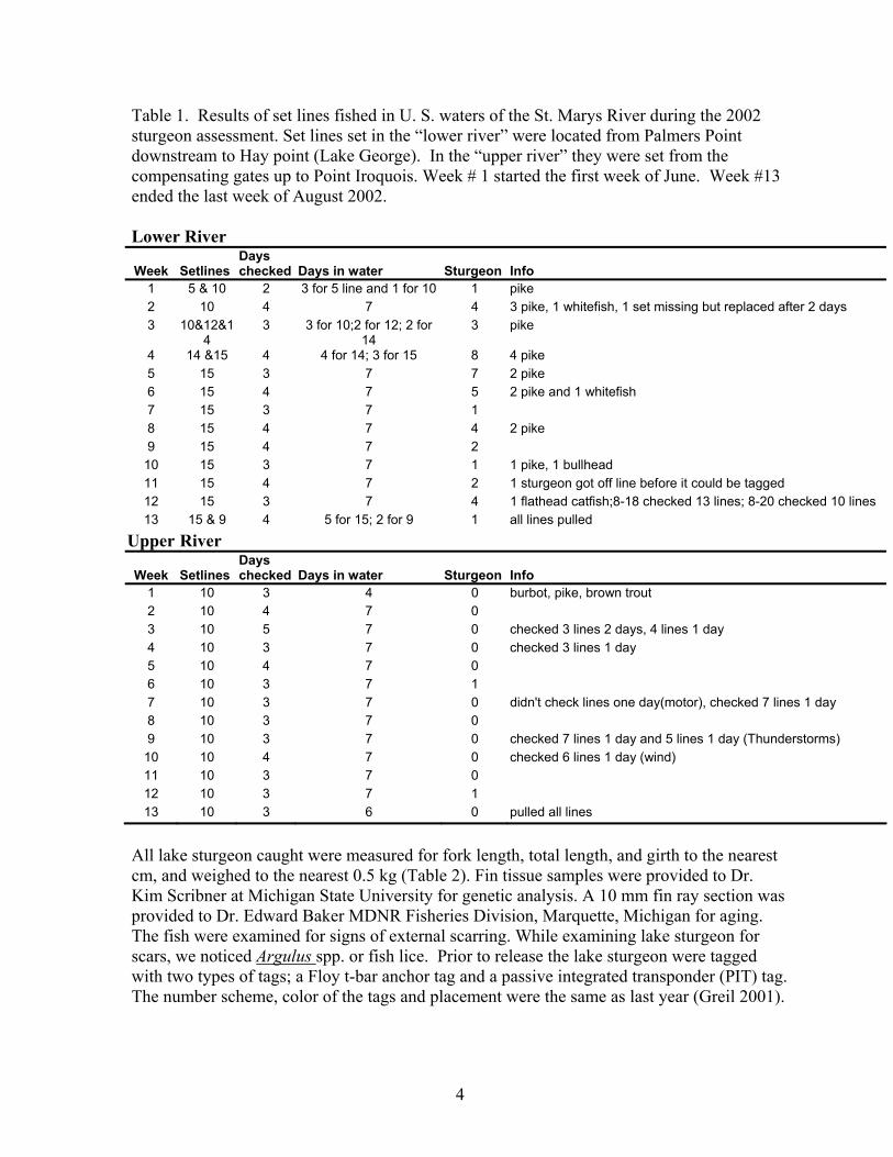
Table 1. Results of set lines fished in U. S. waters of the St. Marys River during the 2002 sturgeon assessment. Set lines set in the “lower river” were located from Palmers Point downstream to Hay point (Lake George). In the “upper river” they were set from the compensating gates up to Point Iroquois. Week # 1 started the first week of June. Week #13 ended the last week of August 2002. Lower River
Week
Setlines
Days checked
Days in water
Sturgeon
Info
1 5 & 10 2 3 for 5 line and 1 for 10 1 pike 2 10 4 7 4 3 pike, 1 whitefish, 1 set missing but replaced after 2 days 3 10&12&1
4 3 3 for 10;2 for 12; 2 for
14 3 pike
4 14 &15 4 4 for 14; 3 for 15 8 4 pike 5 15 3 7 7 2 pike 6 15 4 7 5 2 pike and 1 whitefish 7 15 3 7 1 8 15 4 7 4 2 pike 9 15 4 7 2 10 15 3 7 1 1 pike, 1 bullhead 11 15 4 7 2 1 sturgeon got off line before it could be tagged 12 15 3 7 4 1 flathead catfish;8-18 checked 13 lines; 8-20 checked 10 lines 13 15 & 9 4 5 for 15; 2 for 9 1 all lines pulled
Upper River
Week
Setlines
Days checked
Days in water
Sturgeon
Info
1 10 3 4 0 burbot, pike, brown trout 2 10 4 7 0 3 10 5 7 0 checked 3 lines 2 days, 4 lines 1 day 4 10 3 7 0 checked 3 lines 1 day 5 10 4 7 0 6 10 3 7 1 7 10 3 7 0 didn't check lines one day(motor), checked 7 lines 1 day 8 10 3 7 0 9 10 3 7 0 checked 7 lines 1 day and 5 lines 1 day (Thunderstorms) 10 10 4 7 0 checked 6 lines 1 day (wind) 11 10 3 7 0 12 10 3 7 1 13 10 3 6 0 pulled all lines
All lake sturgeon caught were measured for fork length, total length, and girth to the nearest cm, and weighed to the nearest 0.5 kg (Table 2). Fin tissue samples were provided to Dr. Kim Scribner at Michigan State University for genetic analysis. A 10 mm fin ray section was provided to Dr. Edward Baker MDNR Fisheries Division, Marquette, Michigan for aging. The fish were examined for signs of external scarring. While examining lake sturgeon for scars, we noticed Argulus spp. or fish lice. Prior to release the lake sturgeon were tagged with two types of tags; a Floy t-bar anchor tag and a passive integrated transponder (PIT) tag. The number scheme, color of the tags and placement were the same as last year (Greil 2001).
5
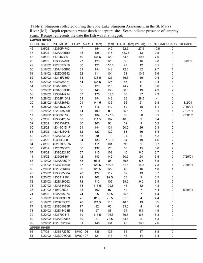
Table 2. Sturgeon collected during the 2002 Lake Sturgeon Assessment in the St. Marys River (MI). Depth represents water depth at capture site. Scars indicate presence of lamprey scars. Recaps represents the date the fish was first tagged. LOWER RIVER FISH # DATE PIT TAG # FLOY TAG # TL (cm) FL (cm) GIRTH (cm) WT (kg) DEPTH (M) SCARS RECAPS 46 6/6/02 42380F4742 47 154 142 62.5 27.5 10.5 0 47 6/8/02 423A4A5E57 48 128 116 48.75 13 9.8 1 48 6/8/02 417946B00 49 131.5 122 54.5 19.5 7.6 0 26 6/8/02 423B58410D 27 126 120 56 16 9.8 0 6/8/02 49 6/12/02 422E097759 50 121 110.5 47 12 8.1 0 50 6/16/02 423A4E0B65 51 154 148 72.5 32 9.7 1 51 6/16/02 422E005852 52 111 104 51 10.5 7.6 0 52 6/20/02 42343F7859 53 138.5 125 56.5 19 9.4 2 53 6/22/02 4238026A71 54 135.5 125 55 17 3.4 1 54 6/24/02 423A510A02 55 129 115 44.7 11 5.8 2 55 6/26/02 423A6D7B05 56 140 130 56.5 19 4.9 2 56 6/26/02 423B444714 57 175 162.5 66 37 4.3 0 57 6/28/02 42352F1D12 58 154 143 66 28.5 4 0 20 6/28/02 423A726763 21 144.5 136 56 21 5.8 0 8/2/01 5 6/28/02 42343D370C 5 116 112 52 15 6.1 0 7/16/01 13 6/28/02 422E13500B 14 100 93 35.5 7 3.1 1 7/27/01 17 6/30/02 4235365736 18 134 127.5 59 20 6.1 5 7/30/02 58 7/2/02 423B642074 59 111.5 102 46.5 9 6.4 0 59 7/2/02 423513242A 60 103 90 39 9 5.2 0 60 7/2/02 42345C1D1F 61 144 131 60.5 26 5.3 0 61 7/2/02 423453304B 62 123 122 53 16 5.4 0 62 7/2/02 423A723F22 63 80 71 34 6 5.2 0 63 7/4/02 42380F358 64 136 135.5 54 19 4.6 2 64 7/6/02 422EOF587A 65 111 101 39.5 9 3.7 1 65 7/6/02 422EO53676 66 137 128 50 15 3.6 2 67 7/8/02 423B62213C 67 115 102 40 8.5 3.7 0 11 7/8/02 4235093464 12 143 142 60.5 24 3.5 0 7/25/01 68 7/10/02 423A6A5C74 68 96.5 85 39.5 6.5 5.8 0 16 7/14/02 423B714460 17 128.5 119.5 51.5 14.5 7.3 1 7/30/01 69 7/20/02 422E226403 69 125.5 122 46 16 1.8 1 70 7/25/02 423B00500A 70 127 117 52 13 3.7 0 71 7/25/02 4235317164 71 102 92.5 38 9 3.5 0 72 7/25/02 422E126062 72 112 102 39.5 9.5 3.5 0 73 7/27/02 423A58480C 73 118.5 109.5 45 12 4.3 0 37 7/31/02 4194C6533 38 102 97 40 7 4.4 0 8/29/01 74 8/8/02 423A505374 74 95 88.5 35.5 7 4.4 0 75 8/10/02 42350D3309 75 81.5 73.5 31.5 4 4.4 0 76 8/16/02 422D7C2276 76 121.5 115 46.5 13 10 0 77 8/18/02 423B01085F 77 92 85 33.5 4 4.6 0 78 8/20/02 422E14423E 78 97 88 34 5.5 4.9 0 79 8/22/02 4237790418 79 118.5 106.5 39.5 8.5 8.3 0 80 8/22/02 423A6C7357 80 87 78.5 34.5 5 4.3 0 82 8/28/02 422E09256A 81 145 131 49 16.5 7.6 0 UPPER RIVER 66 7/7/02 423B6F275D BMIC 126 136 123 55 17 8.8 0 81 8/23/02 423B0D6C08 BMIC 127 121 113 46 14 6.4 0
6
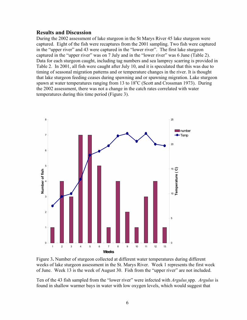
Results and Discussion During the 2002 assessment of lake sturgeon in the St Marys River 45 lake sturgeon were captured. Eight of the fish were recaptures from the 2001 sampling. Two fish were captured in the “upper river” and 43 were captured in the “lower river”. The first lake sturgeon captured in the “upper river” was on 7 July and in the “lower river” was 6 June (Table 2). Data for each sturgeon caught, including tag numbers and sea lamprey scarring is provided in Table 2. In 2001, all fish were caught after July 10, and it is speculated that this was due to timing of seasonal migration patterns and or temperature changes in the river. It is thought that lake sturgeon feeding ceases during spawning and or spawning migration. Lake sturgeon spawn at water temperatures ranging from 13 to 18oC (Scott and Crossman 1973). During the 2002 assessment, there was not a change in the catch rates correlated with water temperatures during this time period (Figure 3).
Figure 3. Number of sturgeon collected at different water temperatures during different weeks of lake sturgeon assessment in the St. Marys River. Week 1 represents the first week of June. Week 13 is the week of August 30. Fish from the “upper river” are not included. Ten of the 43 fish sampled from the “lower river” were infected with Argulus spp. Argulus is found in shallow warmer bays in water with low oxygen levels, which would suggest that
0
1
2
3
4
5
6
7
8
1 2 3 4 5 6 7 8 9 10 11 12 13
Weeks
Num
ber o
f fis
h
0
5
10
15
20
25
Tem
pera
ture
( C
)
numberTemp
7
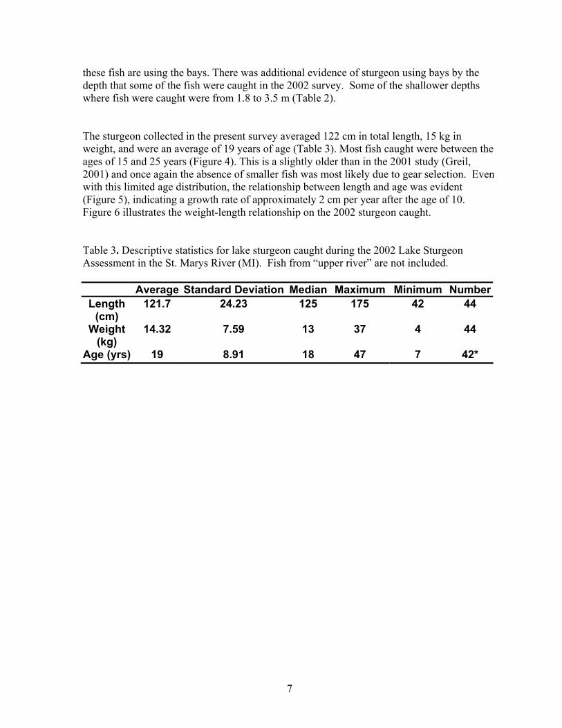
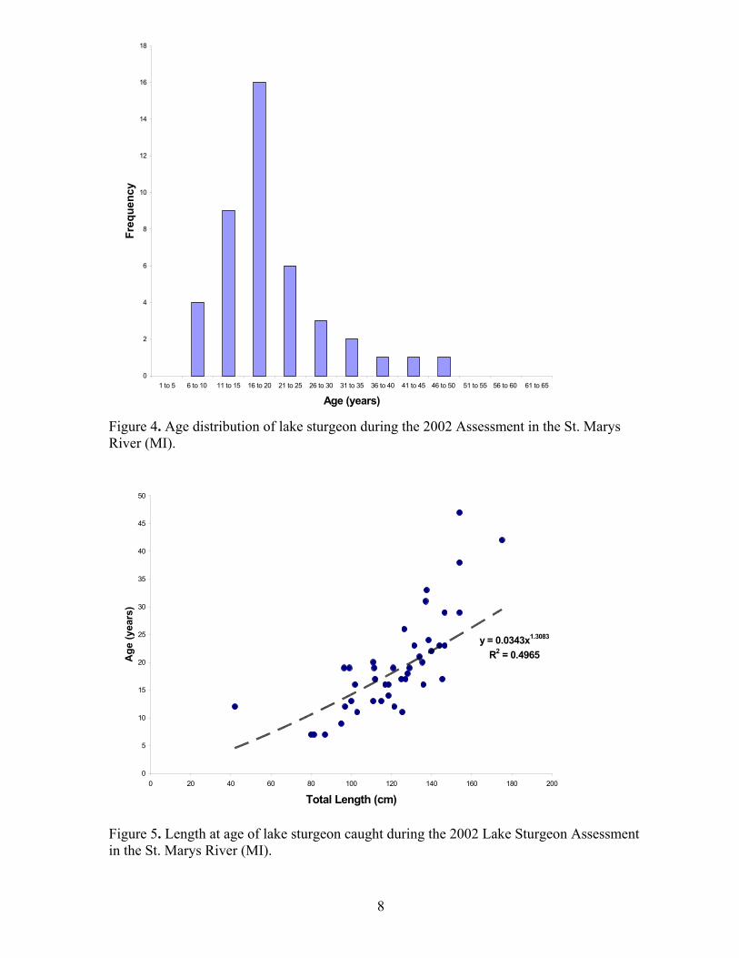
these fish are using the bays. There was additional evidence of sturgeon using bays by the depth that some of the fish were caught in the 2002 survey. Some of the shallower depths where fish were caught were from 1.8 to 3.5 m (Table 2). The sturgeon collected in the present survey averaged 122 cm in total length, 15 kg in weight, and were an average of 19 years of age (Table 3). Most fish caught were between the ages of 15 and 25 years (Figure 4). This is a slightly older than in the 2001 study (Greil, 2001) and once again the absence of smaller fish was most likely due to gear selection. Even with this limited age distribution, the relationship between length and age was evident (Figure 5), indicating a growth rate of approximately 2 cm per year after the age of 10. Figure 6 illustrates the weight-length relationship on the 2002 sturgeon caught. Table 3. Descriptive statistics for lake sturgeon caught during the 2002 Lake Sturgeon Assessment in the St. Marys River (MI). Fish from “upper river” are not included.
Average Standard Deviation Median Maximum Minimum NumberLength
(cm) 121.7 24.23 125 175 42 44
Weight (kg)
14.32 7.59 13 37 4 44
Age (yrs) 19 8.91 18 47 7 42*
8
Figure 4. Age distribution of lake sturgeon during the 2002 Assessment in the St. Marys River (MI).
Figure 5. Length at age of lake sturgeon caught during the 2002 Lake Sturgeon Assessment in the St. Marys River (MI).
0
2
4
6
8
10
12
14
16
18
1 to 5 6 to 10 11 to 15 16 to 20 21 to 25 26 to 30 31 to 35 36 to 40 41 to 45 46 to 50 51 to 55 56 to 60 61 to 65
Age (years)
Freq
uenc
y
y = 0.0343x1.3083
R2 = 0.4965
0
5
10
15
20
25
30
35
40
45
50
0 20 40 60 80 100 120 140 160 180 200
Total Length (cm)
Age
(yea
rs)
9
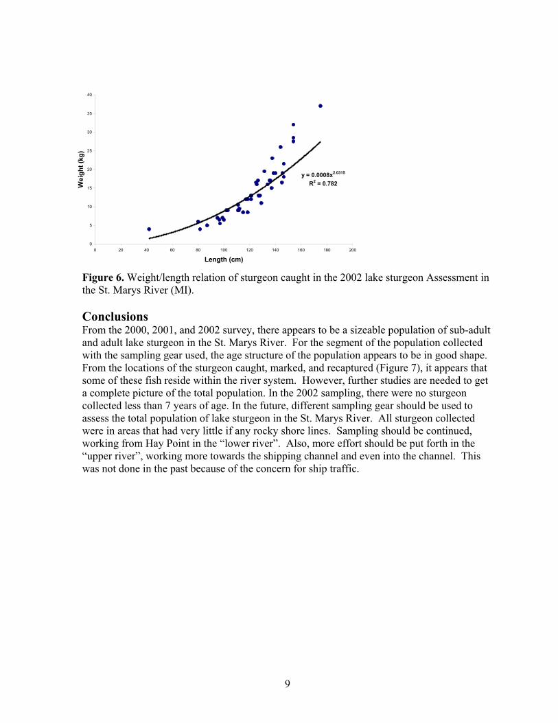
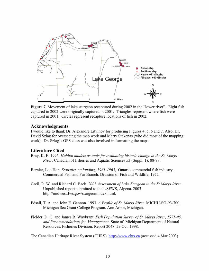
Figure 6. Weight/length relation of sturgeon caught in the 2002 lake sturgeon Assessment in the St. Marys River (MI). Conclusions From the 2000, 2001, and 2002 survey, there appears to be a sizeable population of sub-adult and adult lake sturgeon in the St. Marys River. For the segment of the population collected with the sampling gear used, the age structure of the population appears to be in good shape. From the locations of the sturgeon caught, marked, and recaptured (Figure 7), it appears that some of these fish reside within the river system. However, further studies are needed to get a complete picture of the total population. In the 2002 sampling, there were no sturgeon collected less than 7 years of age. In the future, different sampling gear should be used to assess the total population of lake sturgeon in the St. Marys River. All sturgeon collected were in areas that had very little if any rocky shore lines. Sampling should be continued, working from Hay Point in the “lower river”. Also, more effort should be put forth in the “upper river”, working more towards the shipping channel and even into the channel. This was not done in the past because of the concern for ship traffic.
y = 0.0008x2.0315
R2 = 0.782
0
5
10
15
20
25
30
35
40
0 20 40 60 80 100 120 140 160 180 200
Length (cm)
Wei
ght (
kg)
10
Figure 7. Movement of lake sturgeon recaptured during 2002 in the “lower river”. Eight fish captured in 2002 were originally captured in 2001. Triangles represent where fish were captured in 2001. Circles represent recapture locations of fish in 2002. Acknowledgments I would like to thank Dr. Alexandre Litvinov for producing Figures 4, 5, 6 and 7. Also, Dr. David Szlag for overseeing the map work and Marty Stakenas (who did most of the mapping work). Dr. Szlag’s GPS class was also involved in formatting the maps. Literature Cited Bray, K. E. 1996. Habitat models as tools for evaluating historic change in the St. Marys
River. Canadian of fisheries and Aquatic Sciences 53 (Suppl. 1): 88-98. Bernier, Leo Hon. Statistics on landing, 1961-1965, Ontario commercial fish industry.
Commercial Fish and Fur Branch. Division of Fish and Wildlife, 1972. Greil, R. W. and Richard C. Back. 2003 Assessment of Lake Sturgeon in the St Marys River.
Unpublished report submitted to the USFWS, Alpena. 2003 http://midwest.fws.gov/sturgeon/index.html.
Edsall, T. A. and John E. Gannon. 1993. A Profile of St. Marys River. MICHU-SG-93-700.
Michigan Sea Grant College Program. Ann Arbor, Michigan. Fielder, D. G. and James R. Waybrant. Fish Population Survey of St. Marys River, 1975-95,
and Recommendations for Management. State of Michigan Department of Natural Resources. Fisheries Division. Report 2048. 29 Oct. 1998.
The Canadian Heritage River System (CHRS). http://www.chrs.ca (accessed 4 Mar 2003).

11
Scott, W. B. and E. J. Crossman. 1973 Freshwater Fishes of Canada. Fisheries Research Board of Canada. Bulletin 184, Ottawa.
Sutton, T. M. Summer and Fall 2000 Assessment of Lake Sturgeon in the U. S. Waters of the
St. Marys River. Unpublished report submitted to the USFWS, Alpena 2002. http://midwest.fws.gov/sturgeon/index.html.
Thomas, M. V. and R. C. Haas. 1999. Capture of lake sturgeon with setlines in the St. Clair
River, Michigan. North American Journal of Fisheries Management 10:610-612.
12
Occurrence of Argulus spp. on Lake Sturgeon (Acipenser fulvescens) and Walleye (Stizostedion vitreum) in St. Marys River (MI/On)
Alexandre G. Litvinov*, Richard C. Back, Roger W. Greil,
Lake Superior State University, College Natural and Health Science
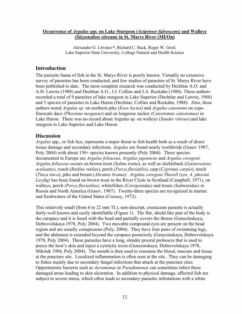
Introduction The parasite fauna of fish in the St. Marys River is poorly known. Virtually no extensive survey of parasites has been conducted, and few studies of parasites of St. Marys River have been published to date. The most complete research was conducted by Dechtiar A.O. and A.H. Lawrie (1988) and Dechtiar A.O., J.J. Collins and J.A. Reckahn (1988). These authors recorded a total of 9 parasites of lake sturgeon in Lake Superior (Dechtiar and Lawrie, 1988) and 5 species of parasites in Lake Huron (Dechtiar, Collins and Reckahn, 1988). Also, these authors noted Argulus sp. on northern pike (Esox lucius) and Argulus catostomi on cope-finescale dace (Phoxinus neogaeus) and on longnose sucker (Catostomus catostomus) in Lake Huron. There was no record about Argulus sp. on walleye (Sander vitreus) and lake sturgeon in Lake Superior and Lake Huron. Discussion Argulus spp., or fish lice, represents a major threat to fish health both as a result of direct tissue damage and secondary infections. Argulus are found nearly worldwide (Gusev 1987, Poly 2004) with about 150+ species known presently (Poly 2004). Three species documented in Europe are Argulus foliaceus, Argulus japonicus and Argulus coregoni. Argulus foliaceus occurs on brown trout (Salmo trutta), as well as stickleback (Gasterosteus aculeatus), roach (Rutilus rutilus), perch (Perca fluviatilis), carp (Cyprinus carpio), tench (Tinca tinca), pike and bream (Abramis brama). Argulus coregoni Thorell (syn. A. phoxini Leydig) has been found on brown trout in the River Clyde in Scotland (Campbell, 1971), on walleye, perch (Perca fluviatilus), whitefishes (Coregonidae) and trouts (Salmonidae) in Russia and North America (Gusev, 1987). Twenty-three species are recognized in marine and freshwaters of the United States (Cressey, 1972). This relatively small (from 6 to 22 mm TL), non-descript, crustacean parasite is actually fairly-well known and easily identifiable (Figure 1). The flat, shield-like part of the body is the carapace and it is fused with the head and partially covers the thorax (Genezinskaya, Dobrovolskaya 1978, Poly 2004). Two movable compound eyes are present on the head region and are usually conspicuous (Poly, 2004). They have four pairs of swimming legs, and the abdomen is extended beyond the carapace posteriorly (Genezinskaya, Dobrovolskaya 1978, Poly 2004). These parasites have a long, slender preoral proboscis that is used to pierce the host’s skin and inject a cytolytic toxin (Genezinskaya, Dobrovolskaya 1978, Mikituk 1984, Poly 2004). The mouth is then used to consume the blood, mucous and tissue at the puncture site. Localized inflammation is often seen at the site. They can be damaging to fishes mainly due to secondary fungal infections that attack at the puncture sites. Opportunistic bacteria such as Aeromonas or Pseudomonas can sometimes infect these damaged areas leading to skin ulceration. In addition to physical damage, affected fish are subject to severe stress, which often leads to secondary parasitic infestations with a white
13
spot and Costia sp. It is possible that Argulus spp. harbor these bacteria, as well as blood parasites such as Trypanosoma spp. Argulus spp. can also transmit fish viral diseases and other fish parasites. As with most fish parasites, Argulus spp. have a high reproductive potential. Mating takes place on the fish, after which the female swims away and lays eggs on plants and other submerged objects. When the eggs hatch the juvenile passes through several metamorphic changes as it develops into an adult. Four days after hatching, the newly-hatched juvenile actively seeks a host and continues its development on the fish. The whole cycle takes between 30 – 100 days depending on temperature. Optimum temperature is 18-22 C. The eggs can over-winter and hatch in spring as water temperatures increase. Adults can survive without a host for up to 15 days and newly hatched larvae can survive one or two days without a host. If species composition of parasite fauna changes in response to eutrophication, one would expect a trend toward predominance of Monogeneans, crustaceans, (e.g., Ergasilus and Argulus) and digenetic Trematodes which are most characteristic of eutrophic habitat.
Results In the summer of 2002 several local anglers turned samples of a fish parasite, collected from walleye, into the LSSU Aquatic Research Laboratory for identification. During our subsequent summer survey on St. Marys River, additional specimens were collected from lake sturgeon. The parasite was identified as an Argulus spp. (coregoni or canadensis) (Figure 2). Ten of the 45 lake sturgeon captured (~25 %) were infected with Argulus spp.
Summary The new occurrence of Argulus spp. in the St. Marys River may be attributed to several factors. It could be that Argulus has been present in low numbers, and was not previously noticed. Heightened angler awareness of parasites and exotic species may have anglers looking more closely at their catch. The temperature dependence for reproduction could also explain the observations as 2002 was warmer and warmer earlier than previous years. Finally, this could be yet another unfortunate introduction of an exotic species to the St. Marys River ecosystem. References Campbell, A.D. 1971. The occurrence of Argulus (Crustacea: Branchiura) in Scotland.
Journal of Fish Biology 3(2): 145-146. Cressey, R.F. 1972. The genus Argulus (Crustacea: Branchiura) of the United States. Biota of
Freshwater Ecosystems, U.S. Environmental Protection Agency Identification Manual 2: viii + 1-14.
Dechtiar A.O., Lawrie A.H. 1988. Survey of the parasite fauna of Lake Superior fishes,
1969-1975. Parasites of fishes in the Canadian waters of the Great Lakes, Tec.Rep. 51, GLFC: 1-19

14
Dechtiar A.O., Collins J.J., Reckahn J.A. 1988. Survey of the parasite fauna of Lake Huron fishes, 1961-1971. Parasites of fishes in the Canadian waters of the Great Lakes, Tec. Rep. 51, GLFC: 19-49
Genezinskaya T.A., Dobrovolskaya A.A. 1978. Practical Parasitology, Vishaya Shkola,
Moscow, Vol 2: 152-154 (in Russian) Gusev A.V. 1987. Family Argulidae. Identification key of parasites of USSR’s freshwater
fishes, Nauka, Leningrad: 515-522 (in Russian) Hoffman G.L. 1998. Parasites of North American Freshwater Fishes, Cornell Univ. Press,
Ithaca: 310-317 Mikituk P.V., Osadchaya E.F., Pogorelzeva T.P. et al. Guide of the fish diseases in the ponds
(Editor Mikituk P.V) 1984 (in Russian) William J. Poly. 2004. http://www.science.siu.edu/zoology/gradstudents/poly/argulus.html Figure 1. Classification The classification is as follows: Phylum Arthropoda Subphylum Crustacea Class Maxillopoda Subclass Branchiura Order Arguloidae Family Argulidae Genus Argulus Species: A. americanus, A. appendiculosus, A. canadensis, A. coregoni, A. catostomi, A. flavencens A. floridensis , A. funduli, A.giordanii, A. ingens A. japonicus, A. laticauda, A. lepidostei, A. longicaudatus, A. maculosus, A. meehani A. mississippiensis, A. nobilis A. pugettensis, A. trilineatus, A. versicolor, A. stizostethi A. biramosus Hoffman G. L. 1998
15
Figure 1. Picture of one of the fish lice taken off of a Lake Sturgeon in the 2002 St. Marys River Lake Sturgeon Survey.
16
LAKE HURON
Ontario Ministry of Natural Resources Lake Huron Management Unit Contact: Lloyd C Mohr E-mail: [email protected]
Lake Huron (including Georgian Bay and the North Channel)
Sturgeon Assessment Update 2002 Introduction The assessment of lake sturgeon (Ascipenser fulvescens) stocks in Ontario waters of Lake Huron (including Georgian Bay and the North Channel) was initiated in 1995 (Mohr 2000). The purpose of this report is to summarize the data collected by the Upper Great Lakes Management Unit – Lake Huron (UGLMU) in 2002. As in previous years, commercial fishermen on Lake Huron incidentally captured sturgeon in either gill nets or trap nets and contributed the majority of the samples for this study (Figure 1). The fish are sampled by staff while on-board commercial vessels, by commercial fishermen or the majority are held in holding facilities until there is a large enough number to be sampled by UGLMU staff. In 2002, a sturgeon spawning assessment of the Nottawasaga River in Georgian Bay was also added to the overall sturgeon project in conjunction with an international effort to gather genetic samples from spawning rivers for stock delineation analysis. The data collected from the various sturgeon projects will be used to assess the genetic health of lake sturgeon populations in Lake Huron. This information will be used to develop a management plan for lake sturgeon in Ontario and International waters of Lake Huron. Further studies in sturgeon movement and migration, as well as the general biology of lake sturgeon found in Lake Huron/Georgian Bay and the North Channel will be used to enhance our understanding of this unique fish and provide recommendations for management actions.
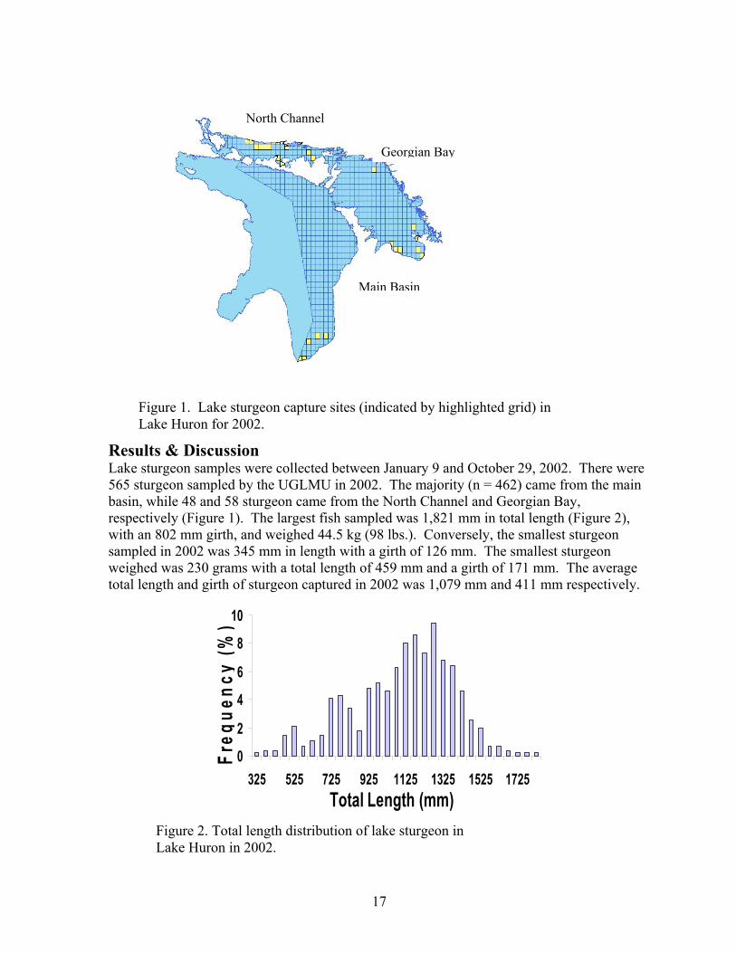
17
Figure 1. Lake sturgeon capture sites (indicated by highlighted grid) in Lake Huron for 2002.
Results & Discussion Lake sturgeon samples were collected between January 9 and October 29, 2002. There were 565 sturgeon sampled by the UGLMU in 2002. The majority (n = 462) came from the main basin, while 48 and 58 sturgeon came from the North Channel and Georgian Bay, respectively (Figure 1). The largest fish sampled was 1,821 mm in total length (Figure 2), with an 802 mm girth, and weighed 44.5 kg (98 lbs.). Conversely, the smallest sturgeon sampled in 2002 was 345 mm in length with a girth of 126 mm. The smallest sturgeon weighed was 230 grams with a total length of 459 mm and a girth of 171 mm. The average total length and girth of sturgeon captured in 2002 was 1,079 mm and 411 mm respectively.
0
2
4
6
8
10
325 525 725 925 1125 1325 1525 1725Total Length (mm)
Freq
uenc
y (%
)
Figure 2. Total length distribution of lake sturgeon in
Lake Huron in 2002.
North Channel
Georgian Bay
Main Basin
18
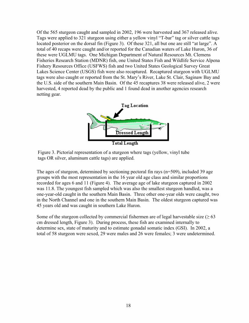
Of the 565 sturgeon caught and sampled in 2002, 196 were harvested and 367 released alive. Tags were applied to 321 sturgeon using either a yellow vinyl “T-bar” tag or silver cattle tags located posterior on the dorsal fin (Figure 3). Of these 321, all but one are still “at large”. A total of 40 recaps were caught and/or reported for the Canadian waters of Lake Huron, 36 of these were UGLMU tags. One Michigan Department of Natural Resources Mt. Clemens Fisheries Research Station (MDNR) fish, one United States Fish and Wildlife Service Alpena Fishery Resources Office (USFWS) fish and two United States Geological Survey Great Lakes Science Center (USGS) fish were also recaptured. Recaptured sturgeon with UGLMU tags were also caught or reported from the St. Mary’s River, Lake St. Clair, Saginaw Bay and the U.S. side of the southern Main Basin. Of the 45 recaptures 38 were released alive, 2 were harvested, 4 reported dead by the public and 1 found dead in another agencies research netting gear.
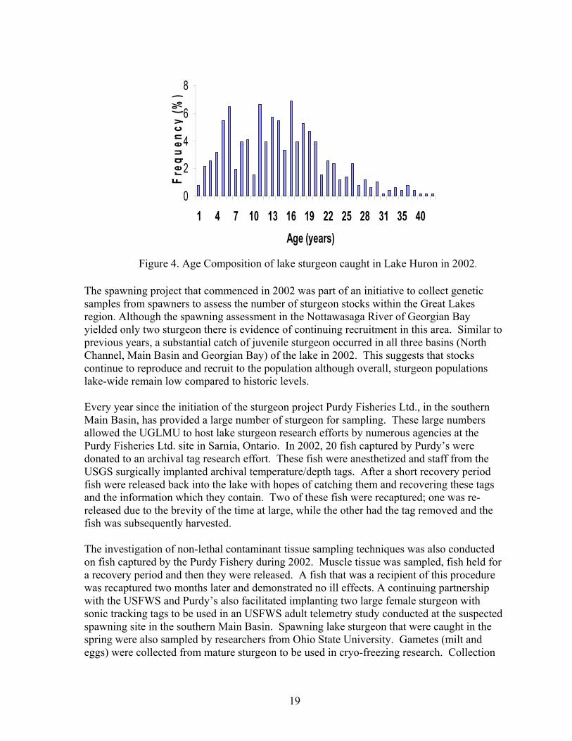
The ages of sturgeon, determined by sectioning pectoral fin rays (n=509), included 39 age groups with the most representation in the 16 year old age class and similar proportions recorded for ages 6 and 11 (Figure 4). The average age of lake sturgeon captured in 2002 was 11.8. The youngest fish sampled which was also the smallest sturgeon handled, was a one-year-old caught in the southern Main Basin. Three other one-year olds were caught, two in the North Channel and one in the southern Main Basin. The oldest sturgeon captured was 45 years old and was caught in southern Lake Huron. Some of the sturgeon collected by commercial fishermen are of legal harvestable size (≥ 63 cm dressed length, Figure 3). During process, these fish are examined internally to determine sex, state of maturity and to estimate gonadal somatic index (GSI). In 2002, a total of 58 sturgeon were sexed, 29 were males and 26 were females; 3 were undetermined.
Figure 3. Pictorial representation of a sturgeon where tags (yellow, vinyl tube tags OR silver, aluminum cattle tags) are applied.
19
Figure 4. Age Composition of lake sturgeon caught in Lake Huron in 2002.
0
2
4
6
8
1 4 7 10 13 16 19 22 25 28 31 35 40Age (years)
Freq
uenc
y (%
)
The spawning project that commenced in 2002 was part of an initiative to collect genetic samples from spawners to assess the number of sturgeon stocks within the Great Lakes region. Although the spawning assessment in the Nottawasaga River of Georgian Bay yielded only two sturgeon there is evidence of continuing recruitment in this area. Similar to previous years, a substantial catch of juvenile sturgeon occurred in all three basins (North Channel, Main Basin and Georgian Bay) of the lake in 2002. This suggests that stocks continue to reproduce and recruit to the population although overall, sturgeon populations lake-wide remain low compared to historic levels. Every year since the initiation of the sturgeon project Purdy Fisheries Ltd., in the southern Main Basin, has provided a large number of sturgeon for sampling. These large numbers allowed the UGLMU to host lake sturgeon research efforts by numerous agencies at the Purdy Fisheries Ltd. site in Sarnia, Ontario. In 2002, 20 fish captured by Purdy’s were donated to an archival tag research effort. These fish were anesthetized and staff from the USGS surgically implanted archival temperature/depth tags. After a short recovery period fish were released back into the lake with hopes of catching them and recovering these tags and the information which they contain. Two of these fish were recaptured; one was re-released due to the brevity of the time at large, while the other had the tag removed and the fish was subsequently harvested. The investigation of non-lethal contaminant tissue sampling techniques was also conducted on fish captured by the Purdy Fishery during 2002. Muscle tissue was sampled, fish held for a recovery period and then they were released. A fish that was a recipient of this procedure was recaptured two months later and demonstrated no ill effects. A continuing partnership with the USFWS and Purdy’s also facilitated implanting two large female sturgeon with sonic tracking tags to be used in an USFWS adult telemetry study conducted at the suspected spawning site in the southern Main Basin. Spawning lake sturgeon that were caught in the spring were also sampled by researchers from Ohio State University. Gametes (milt and eggs) were collected from mature sturgeon to be used in cryo-freezing research. Collection
20
and freezing of these gametes is to be used as a “safety net” in case sturgeon continue to decline and hatchery programs are needed to rehabilitate the species. Partnerships and co-operation with the commercial fishermen and other agencies surrounding the Great Lakes as well as an increased public interest led to these new aspects in lake sturgeon research in Lake Huron in 2002. This information on lake sturgeon is also being used to aid in the development of a “tool box” or suite of management tools in an effort to standardize the management direction for lake sturgeon in Ontario. The development of a standard management plan that is agreeable for all interested parties should lead to more easily implemented regulations which will aid in the continued rehabilitation of this species. Hopefully with continued co-operation and support from governmental, educational and public organization this goal will be achieved. Acknowledgements This important and valuable data could not have been collected without the continued support of the commercial fishing industry on Lake Huron, First Nations around the lake, international partners such as the U.S. Fish and Wildlife Service, Michigan Department of Natural Resources, and United States Geological Survey and the numerous volunteers and staff who continue to participate in data collection. Thank you to all involved in the various aspects of this project. Reference Mohr, L.C. 1999. Lake Sturgeon in Ontario waters of Lake Huron – 1998/99 Update.
Unpublished report. Ontario Ministry of Natural Resources. Upper Great Lakes Management Unit. Owen Sound, Ontario.
For more information or to report a tagged sturgeon please call or write: Lloyd C. Mohr Assessment Team Leader Upper Great Lakes Management Unit – Lake Huron Office Ontario Ministry of Natural Resources Owen Sound, Ontario (519) 371-5669 FAX (519) 371-5844 [email protected]
21
U.S. Fish and Wildlife Service Alpena Fishery Resources Office Contact: Adam Kowalski E-mail: [email protected]
Summary: A total of 57 lake sturgeon was captured by Lake Huron commercial fishers in 2002. This represents the second largest number of sturgeon collected in a single year since the program began in 1995. Sturgeon were collected in trap nets, tagged and released alive. Pectoral fin ray sections were collected and used to age fish. The majority of lake sturgeon captured by commercial fishers are less than 20 years old. Total number of fish tagged since this study started in 1995 is 302. Tag recaptures continue to increase every year. Nine sturgeon captured in 2002 had previously been tagged. This represents 3% of the total lake sturgeon tagged to date. Methods Michigan state-licensed and tribal commercial fishers encounter lake sturgeon as by-catch while using trap nets to harvest lake whitefish (Coregonus clupeaformis), yellow perch (Perca flavescens), and channel catfish (Ictalurus punctatus). Through a volunteer program with the US Fish and Wildlife Service and the Michigan Department of Natural Resources biological data is recorded from these incidentally caught lake sturgeon. Total length (TL), fork length (FL), and girth were measured for most lake sturgeon and the left pectoral fin ray was removed from some fish. All sturgeon were returned to the water live. Cross-sections of the fin rays were used to determine fish age (Figure 1).
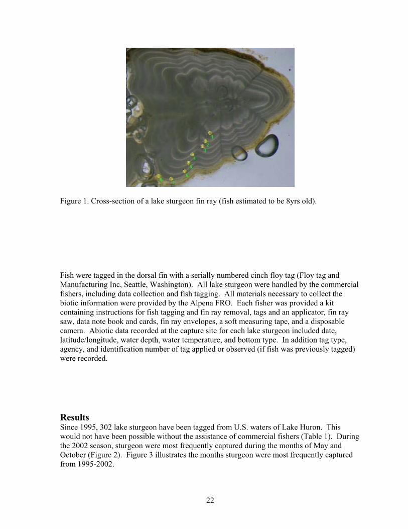
22
Figure 1. Cross-section of a lake sturgeon fin ray (fish estimated to be 8yrs old).
Fish were tagged in the dorsal fin with a serially numbered cinch floy tag (Floy tag and Manufacturing Inc, Seattle, Washington). All lake sturgeon were handled by the commercial fishers, including data collection and fish tagging. All materials necessary to collect the biotic information were provided by the Alpena FRO. Each fisher was provided a kit containing instructions for fish tagging and fin ray removal, tags and an applicator, fin ray saw, data note book and cards, fin ray envelopes, a soft measuring tape, and a disposable camera. Abiotic data recorded at the capture site for each lake sturgeon included date, latitude/longitude, water depth, water temperature, and bottom type. In addition tag type, agency, and identification number of tag applied or observed (if fish was previously tagged) were recorded.
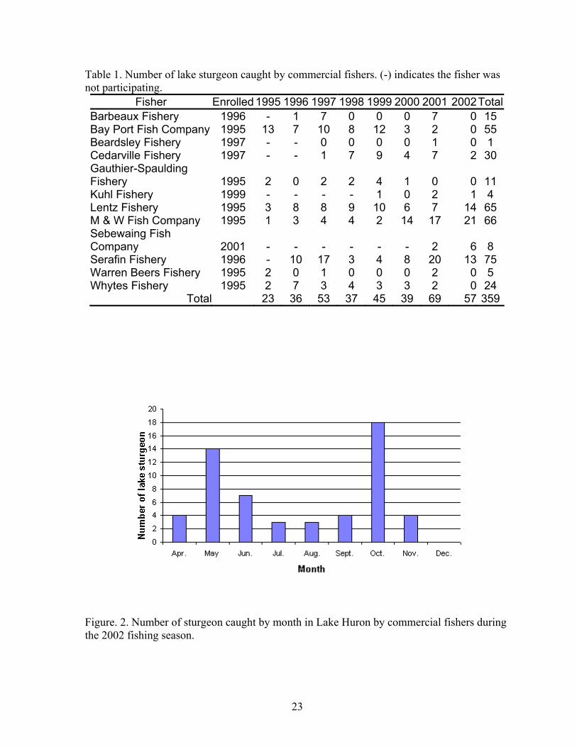
Results Since 1995, 302 lake sturgeon have been tagged from U.S. waters of Lake Huron. This would not have been possible without the assistance of commercial fishers (Table 1). During the 2002 season, sturgeon were most frequently captured during the months of May and October (Figure 2). Figure 3 illustrates the months sturgeon were most frequently captured from 1995-2002.
23
Table 1. Number of lake sturgeon caught by commercial fishers. (-) indicates the fisher was not participating.
Fisher Enrolled 1995 1996 1997 1998 1999 2000 2001 2002TotalBarbeaux Fishery 1996 - 1 7 0 0 0 7 0 15 Bay Port Fish Company 1995 13 7 10 8 12 3 2 0 55 Beardsley Fishery 1997 - - 0 0 0 0 1 0 1 Cedarville Fishery 1997 - - 1 7 9 4 7 2 30 Gauthier-Spaulding Fishery 1995 2 0 2 2 4 1 0 0 11 Kuhl Fishery 1999 - - - - 1 0 2 1 4 Lentz Fishery 1995 3 8 8 9 10 6 7 14 65 M & W Fish Company 1995 1 3 4 4 2 14 17 21 66 Sebewaing Fish Company 2001 - - - - - - 2 6 8 Serafin Fishery 1996 - 10 17 3 4 8 20 13 75 Warren Beers Fishery 1995 2 0 1 0 0 0 2 0 5 Whytes Fishery 1995 2 7 3 4 3 3 2 0 24
Total 23 36 53 37 45 39 69 57 359
Figure. 2. Number of sturgeon caught by month in Lake Huron by commercial fishers during the 2002 fishing season.
24
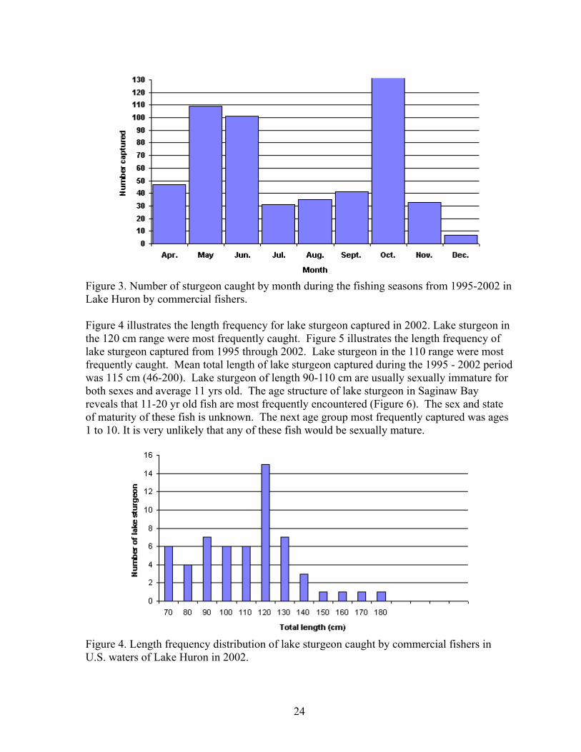
Figure 3. Number of sturgeon caught by month during the fishing seasons from 1995-2002 in Lake Huron by commercial fishers. Figure 4 illustrates the length frequency for lake sturgeon captured in 2002. Lake sturgeon in the 120 cm range were most frequently caught. Figure 5 illustrates the length frequency of lake sturgeon captured from 1995 through 2002. Lake sturgeon in the 110 range were most frequently caught. Mean total length of lake sturgeon captured during the 1995 - 2002 period was 115 cm (46-200). Lake sturgeon of length 90-110 cm are usually sexually immature for both sexes and average 11 yrs old. The age structure of lake sturgeon in Saginaw Bay reveals that 11-20 yr old fish are most frequently encountered (Figure 6). The sex and state of maturity of these fish is unknown. The next age group most frequently captured was ages 1 to 10. It is very unlikely that any of these fish would be sexually mature.
Figure 4. Length frequency distribution of lake sturgeon caught by commercial fishers in U.S. waters of Lake Huron in 2002.
25
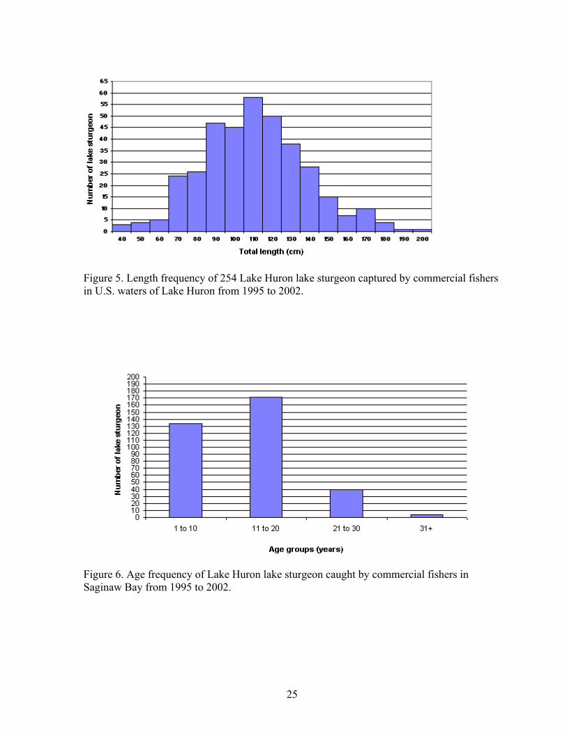
Figure 5. Length frequency of 254 Lake Huron lake sturgeon captured by commercial fishers in U.S. waters of Lake Huron from 1995 to 2002.
Figure 6. Age frequency of Lake Huron lake sturgeon caught by commercial fishers in Saginaw Bay from 1995 to 2002.
26
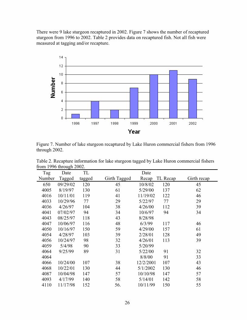
There were 9 lake sturgeon recaptured in 2002. Figure 7 shows the number of recaptured sturgeon from 1996 to 2002. Table 2 provides data on recaptured fish. Not all fish were measured at tagging and/or recapture.
Figure 7. Number of lake sturgeon recaptured by Lake Huron commercial fishers from 1996 through 2002.
Table 2. Recapture information for lake sturgeon tagged by Lake Huron commercial fishers from 1996 through 2002.
Tag Number
Date Tagged
TL tagged Girth Tagged
Date Recap TL Recap Girth recap
650 09/29/02 120 45 10/8/02 120 45 4005 8/19/97 130 61 5/29/00 137 62 4016 10/11/01 119 41 11/19/02 122 46 4033 10/29/96 77 29 5/22/97 77 29 4036 4/26/97 104 38 4/26/00 112 39 4041 07/02/97 94 34 10/6/97 94 34 4043 08/25/97 118 43 8/28/98 4047 10/06/97 116 48 6/3/99 117 46 4050 10/16/97 150 59 4/29/00 157 61 4054 4/28/97 103 39 2/28/01 128 49 4056 10/24/97 98 32 4/26/01 113 39 4059 5/4/98 90 33 5/20/99 4064 9/25/99 89 31 5/22/00 91 32 4064 8/8/00 91 33 4066 10/24/00 107 38 12/2/2001 107 43 4068 10/22/01 130 44 5/1/2002 130 46 4087 10/04/98 147 57 10/10/98 147 57 4093 4/17/99 140 58 5/14/01 142 58 4110 11/17/98 152 56. 10/11/99 150 55
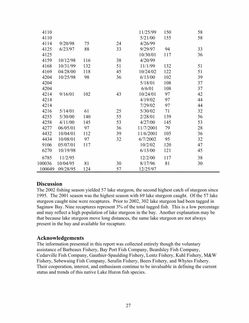
27
4110 11/25/99 150 58 4110 5/21/00 155 58 4114 9/20/98 75 24 4/26/99 4125 6/23/97 88 33 9/29/97 94 33 4125 10/30/01 117 36 4159 10/12/98 116 38 4/20/99 4168 10/31/99 132 51 11/1/99 132 51 4169 04/28/00 118 45 10/24/02 122 51 4204 10/25/98 98 36 6/13/00 102 39 4204 5/18/01 108 37 4204 6/6/01 108 37 4214 9/16/01 102 43 10/24/01 97 42 4214 4/19/02 97 44 4214 7/29/02 97 44 4216 5/14/01 61 25 5/30/02 71 32 4255 5/30/00 140 55 2/28/01 139 56 4258 4/11/00 145 53 4/27/00 145 53 4277 06/05/01 97 36 11/7/2001 79 28 4432 10/04/01 112 39 11/6/2001 105 36 4434 10/08/01 97 32 6/7/2002 95 32 9106 05/07/01 117 10/2/02 120 47 6270 10/19/98 6/13/00 121 45 6785 11/2/95 12/2/00 117 38
100036 10/04/95 81 30 8/17/96 81 30 100049 09/28/95 124 57 12/25/97
Discussion The 2002 fishing season yielded 57 lake sturgeon, the second highest catch of sturgeon since 1995. The 2001 season was the highest season with 69 lake sturgeon caught. Of the 57 lake sturgeon caught nine were recaptures. Prior to 2002, 302 lake sturgeon had been tagged in Saginaw Bay. Nine recaptures represent 3% of the total tagged fish. This is a low percentage and may reflect a high population of lake sturgeon in the bay. Another explanation may be that because lake sturgeon move long distances, the same lake sturgeon are not always present in the bay and available for recapture. Acknowledgements The information presented in this report was collected entirely though the voluntary assistance of Barbeaux Fishery, Bay Port Fish Company, Beardsley Fish Company, Cedarville Fish Company, Gauthier-Spaulding Fishery, Lentz Fishery, Kuhl Fishery, M&W Fishery, Sebewaing Fish Company, Serafin Fishery, Beers Fishery, and Whytes Fishery. Their cooperation, interest, and enthusiasm continue to be invaluable in defining the current status and trends of this native Lake Huron fish species.
28
U.S. Fish and Wildlife Service Marquette Biological Station Contact: John Weisser E-mail: [email protected]
Fisheries and Oceans Canada Sea Lamprey Control Center Contact: Jerry Weise E-mail: [email protected]
Integrated Management of Sea Lampreys Related to Lake
Sturgeons in the Great Lakes Since the 1950s, the U.S. Fish and Wildlife Service (Service) and Department of Fisheries and Oceans of Canada (DFO) have been contracted by the Great Lakes Fishery Commission to conduct operational activities of the Integrated Sea Lamprey Management Program (Program) in streams throughout the Great Lakes basin. The Program continues to work with fisheries management agencies to achieve consensus on sea lamprey control, complement jurisdictional fisheries management plans, apply the ecosystem approach, use adaptive management strategies, and minimize the risk to nontarget organisms. The Program has reduced populations of sea lamprey by 90% in the basin and is a key fishery management project that contributes to the success of the Great Lakes fishery and related economic activities in the basin, an estimated annual benefit of about $4 to $6 billion to the region. The Program uses several techniques to attack sea lamprey during different stages of its life cycle with the support and approval of fisheries management and regulatory agencies. Currently, the primary method used to control sea lamprey is the application of lampricides (treatments): Lampricid® Sea Lamprey Larvicide [active ingredient 3-trifluoromethyl-4-nitrophenol (TFM)], the combination of TFM and Bayluscide 70% wettable powder [active ingredient 2’,5-dichloro-4’-nitrosalicylanilide (niclosamide)], and niclosamide released from Bayluscide 3.2% Granular Sea Lamprey Larvicide to kill sea lamprey larvae in streams with little or no impact on other fishes. Other methods of sea lamprey control include barriers to block the upstream migration of spawning lamprey, traps to capture and remove spawning lamprey, and the sterile-male-release-technique to reduce the success of spawning lamprey.

29
The lake sturgeon is among the nontarget fishes most sensitive to TFM. Young-of-the-year (YOY) lake sturgeon approximately 15 to 100 mm total length (T.L) are most vulnerable to lampricides, usually during May 15 to July 15. Since 1989, the Program has established partnerships with agencies in the basin to identify lake sturgeon spawning streams and conducted toxicity tests using TFM and the combination of TFM and niclosamide to determine the LC 99.9 for larval sea lamprey and cause no mortality on lake sturgeon. Additional studies found that lake sturgeon will avoid niclosamide released from the granular formulation of Bayluscide and will not be harmed. State, provincial, and tribal agencies determine lake sturgeon streams where present production occurs. In streams where sea lampreys and lake sturgeon co-exist, consultations are conducted with jurisdictional agencies to achieve consensus on specialized treatment protocols to control sea lamprey and minimize the risk to lake sturgeon. Lampricide treatments and lake sturgeon assessments in the USA During 2002, the Service achieved consensus with the Michigan Department of Natural Resources to manage lampricide treatments to control sea lamprey and protect known or suspected populations of lake sturgeon in state-designated lake sturgeon streams in Michigan: the Tahquamenon River (Lake Superior), Manistique and Muskegon rivers (Lake Michigan), and Rifle River (Lake Huron). Assessments by dip net during and immediately after the treatments found no dead lake sturgeons. One live YOY lake sturgeon, about 150 mm T.L., was observed during the treatment of the Rifle River on October 1. The assessments were completed to fulfill requirements specified in the 2002 certification of approval issued for lampricide treatments by the Michigan Department of Environmental Quality. Lampricide treatments and lake sturgeon assessments in Canada and the USA During 2002, the DFO achieved consensus with jurisdictional agencies to manage lampricide treatments to control sea lamprey and minimize the risk in seven historical lake sturgeon spawning streams: with the Ontario Ministry of Natural Resources in the Kaministiquia (Kam) and Goulais rivers (Lake Superior) and Garden, Thessalon, Spanish, and Nottawasaga rivers (Lake Huron) and New York State Department of Environmental Conservation in the Black River (Lake Ontario). Larval lake sturgeon fyke nets were fished in three rivers (the Nottawasaga, Thessalon, and Goulais rivers) to confirm sturgeon reproduction before lampricide treatments. The fykes in the Nottawasaga River were fished before lake sturgeon had spawned in the river but many adult lake sturgeon were observed on gravel beds during the lampricide treatment (May 28-31). Six larval lake sturgeon were collected from the Thessalon River above Rock Lake immediately before the lampricide treatment from the fyke net sets. Limited fyke net fishing in the Goulais failed to find larval lake sturgeon before the treatment. Random sites were surveyed during the lampricide applications in two rivers (the Thessalon and Goulais rivers) to estimate nontarget mortality of larval lake sturgeon. In the Thessalon

30
River, 10% of the stream above Rock Lake, where conditions afforded good observation, was sampled for nontarget mortality. Almost 5.6 ha of habitat were examined and no lake sturgeon mortality was observed. In the Goulais River almost 17.4 ha (9%) of suitable habitat was surveyed and no lake sturgeon mortality was observed. One adult sturgeon was observed swimming in the river during the surveys of the Goulais River and a YOY lake sturgeon (141 mm T.L.) was observed (August 12) in the river about one month after the lampricide treatment in the river. During the lampricide treatment of the Kaministiquia (Kam) River in Lake Superior, a single YOY lake sturgeon mortality was observed. The lake sturgeon was 78 mm T.L. on August 12. Note that the sturgeon was about half the length of the sturgeon found in the Goulais River at the same time. Stream temperatures in the Kam may be slightly warmer than the Goulais so it is reasonable to suggest that the sturgeon in the Kam was from a late or multiple spawning in this river. Partner agencies also shared information about lake sturgeon observations. Pukaskwa Park staff reported that lake sturgeon regularly spawn in the White River of Lake Superior. Merrill Maracle, a biologist with the Tyendinaga Mohawk reported that adult lake sturgeon were observed by Mohawks on the Bay of Quinte from the Trent and Salmon rivers of Lake Ontario in 2002. Links to the sea lamprey management program and lake sturgeon: Lake Sturgeon and Sea Lamprey Control in the USA http://midwest.fws.gov/Marquette/etc/sturgeon.html Sea Lamprey Control in Canada http://www.dfo-mpo.gc.ca/media/backgrou/1996/hq-ac62_e.htm Strategic Vision of the Great Lakes Fishery Commission for the First Decade of the New Millennium (pages 6 to 9) http://www.glfc.org/pubs/SpecialPubs/StrategicVision2001.pdf Joint Strategic Plan for Management of Great Lakes Fisheries (1997 Revision) http://www.glfc.org/fishmgmt/sglfmp97.htm
31
U.S. Fish and Wildlife Service Ashland Fishery Resources Contact: Henry Quinlan E-mail: [email protected]
U.S. Geological Survey Hammond Bay Biological Station Contact: Roger Bergstedt E-mail: [email protected]
Summary: In 2002, a collaborative 2-year pilot project was initiated by OMNR, Purdy Fisheries, Ltd., USGS, and the USFWS to examine the feasibility of archival tags to describe habitat use by lake sturgeon in southern Lake Huron. The internal archival tags record depth and temperature at intervals of an hour or less and provide a tremendous quantity of previously unobtainable data that could substantially refine our understanding of habitat selection. In 2002, twenty lake sturgeons were surgically outfitted with archival tags and released. Tags were recovered from 2 recaptured sturgeons. The purpose of this project was to determine if archival tags could be a useful tool for gathering data on habitat (depth and temperature) utilized by lake sturgeon at-large in the open waters of the Great Lakes. Since sturgeon often move long distances and occupy depths over 20 m in the Great Lakes, tracking can be difficult or impossible. Currently most information is gathered from point in time information gathered during agency assessments or by monitoring commercial by-catch. The archival tags provide a means to acquire habitat data on a fish at-large on a relatively continuous basis. In June of 2002, lake sturgeons captured by Purdy Fisheries Ltd. of Sarnia, Ontario, were provided to OMNR for this study. Twenty lake sturgeons were selected in an attempt to implant a similar number of tags in male and female fish. Biological data was collected on each fish. When possible, fish sex was positively determined by internal examination of gonads while tags were surgically implanted in the abdomen. All fish also received two orange, external Floy tags conspicuously placed on either side of the fish, near the insertion of the dorsal fin. The external tags provided a contact phone number and advertise a $100 (US) reward for the return of the tag and fish. After surgery, fish were returned to raceways at Purdy’s for recovery and observation. After 10+ days in raceways, no mortality or abnormal behavior was observed. The fish were then transported in live wells aboard fishing vessels and released in southern Lake Huron.
32
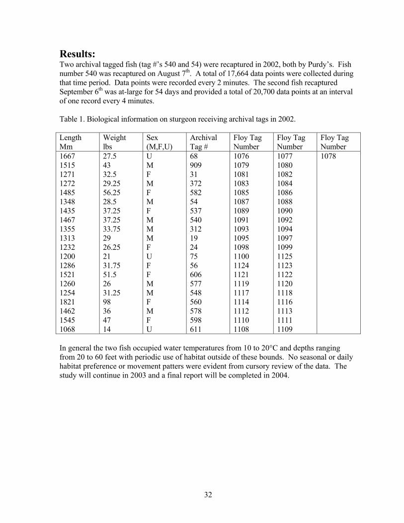
Results: Two archival tagged fish (tag #’s 540 and 54) were recaptured in 2002, both by Purdy’s. Fish number 540 was recaptured on August 7th. A total of 17,664 data points were collected during that time period. Data points were recorded every 2 minutes. The second fish recaptured September 6th was at-large for 54 days and provided a total of 20,700 data points at an interval of one record every 4 minutes. Table 1. Biological information on sturgeon receiving archival tags in 2002. Length Mm
Weight lbs
Sex (M,F,U)
Archival Tag #
Floy Tag Number
Floy Tag Number
Floy Tag Number
1667 1515 1271 1272 1485 1348 1435 1467 1355 1313 1232 1200 1286 1521 1260 1254 1821 1462 1545 1068
27.5 43 32.5 29.25 56.25 28.5 37.25 37.25 33.75 29 26.25 21 31.75 51.5 26 31.25 98 36 47 14
U M F M F M F M M M F U F F M M F M F U
68 909 31 372 582 54 537 540 312 19 24 75 56 606 577 548 560 578 598 611
1076 1079 1081 1083 1085 1087 1089 1091 1093 1095 1098 1100 1124 1121 1119 1117 1114 1112 1110 1108
1077 1080 1082 1084 1086 1088 1090 1092 1094 1097 1099 1125 1123 1122 1120 1118 1116 1113 1111 1109
1078
In general the two fish occupied water temperatures from 10 to 20°C and depths ranging from 20 to 60 feet with periodic use of habitat outside of these bounds. No seasonal or daily habitat preference or movement patters were evident from cursory review of the data. The study will continue in 2003 and a final report will be completed in 2004.
33
ST. CLAIR WATERWAY
Michigan Department of Natural Resources Mt. Clemens Fisheries Research Station Contact: Mike Thomas E-mail: [email protected]
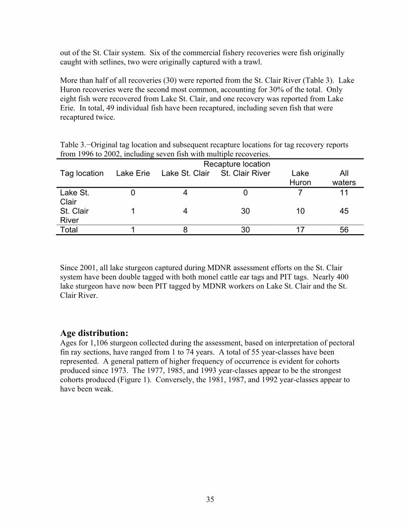
Summary: Since 1996, over 1,200 lake sturgeon have been caught, tagged, and released in the St. Clair system. A total of 56 tag recoveries have been reported. Fifty-five year classes have been represented in the catch. Age 3 or younger fish remain scarce in our assessment sampling. Results of Michigan Department of Natural Resources (MDNR) investigations of abundance, age composition, and spatial distribution of lake sturgeon in the St. Clair system were reported by Thomas and Haas (2002).
The Lake St. Clair Fisheries Research Station began an investigation into the distribution and abundance of lake sturgeon in the St. Clair River and Lake St. Clair in 1996. Since 1997, the study has been funded through the Federal Aid for Sport Fish Restoration program. At various stages, this project has included collaborative efforts with the University of Michigan, Detroit Edison, the U.S. Fish and Wildlife Service Alpena Fishery Resources Office, the U.S. Geological Survey Great Lake Science Center, and the Ontario Ministry of Natural Resources Upper Great Lakes Management Unit. The objectives of this study are (1) to determine spawning period, spatial distribution of spawning activity, and characterize spawning habitat for lake sturgeon in the St. Clair River, (2) to determine early (juvenile) life history of lake sturgeon in the St. Clair River and Lake St. Clair, and identify habitat requirements of lake sturgeon, (3) to document lake sturgeon population parameters for Lake St. Clair and the St. Clair River, including estimated abundance, exploitation, age composition, growth rate, and age/sex composition of the spawning stock. Tagging results: From May 1996 to October 2002, MDNR assessment efforts captured 1,238 lake sturgeon. A total of 489 fish were captured with 434 setline lifts in the St. Clair River. In Lake St. Clair, a total of 1,290 trawl tows resulted in 721 sturgeon captured. Additionally, 28 sturgeon were caught with trap nets (17 fish in 56 net lifts) and gill nets (11 fish in 3 net lifts) in Lake St. Clair. In total, 1,201 lake sturgeon caught with assessment gear were tagged and released. Sturgeon caught with setlines in the St. Clair River were significantly older, longer, and heavier (α=0.05) than those caught with trawls from Lake St. Clair (Table 1). Table 1.−Mean length, weight, girth, and age for sturgeon collected from the St. Clair River and Lake St. Clair, from 1996 to 2002.
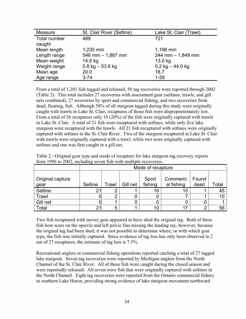
34
Measure St. Clair River (Setline) Lake St. Clair (Trawl) Total number caught
489 721
Mean length 1,235 mm 1,198 mm Length range 546 mm – 1,887 mm 244 mm – 1,849 mm Mean weight 14.6 kg 13.0 kg Weight range 0.8 kg – 53.6 kg 0.2 kg – 44.0 kg Mean age 20.0 18.7 Age range 3-74 1-59 From a total of 1,201 fish tagged and released, 56 tag recoveries were reported through 2002 (Table 2). This total includes 27 recoveries with assessment gear (setlines, trawls, and gill nets combined), 27 recoveries by sport and commercial fishing, and two recoveries from dead, floating, fish. Although 58% of all sturgeon tagged during this study were originally caught with trawls in Lake St. Clair, recaptures of those fish were disproportionately low. From a total of 56 recaptures only 10 (20%) of the fish were originally captured with trawls in Lake St. Clair. A total of 21 fish were recaptured with setlines, while only five lake sturgeon were recaptured with the trawls. All 21 fish recaptured with setlines were originally captured with setlines in the St. Clair River. Two of the sturgeon recaptured in Lake St. Clair with trawls were originally captured with a trawl, while two were originally captured with setlines and one was first caught in a gill net. Table 2.−Original gear type and mode of recapture for lake sturgeon tag recovery reports from 1996 to 2002, including seven fish with multiple recoveries. Mode of recapture Original capture gear Setline Trawl Gill net
Sport fishing
Commercial fishing
Found dead Total
Setline 21 2 1 10 10 1 45Trawl 0 2 0 0 7 1 10Gill net 0 1 0 0 0 0 1Total 21 5 1 10 17 2 56 Two fish recaptured with survey gear appeared to have shed the original tag. Both of these fish bore scars on the opercle and left pelvic fins missing the leading ray, however, because the original tag had been shed, it was not possible to determine where, or with which gear type, the fish was initially captured. Since evidence of tag loss has only been observed in 2 out of 27 recaptures, the estimate of tag loss is 7.5%. Recreational anglers or commercial fishing operations reported catching a total of 27 tagged lake sturgeon. Seven tag recoveries were reported by Michigan anglers from the North Channel of the St. Clair River. All of these fish were caught during the closed season and were reportedly released. All seven were fish that were originally captured with setlines in the North Channel. Eight tag recoveries were reported from the Ontario commercial fishery in southern Lake Huron, providing strong evidence of lake sturgeon movement northward
35
out of the St. Clair system. Six of the commercial fishery recoveries were fish originally caught with setlines, two were originally captured with a trawl. More than half of all recoveries (30) were reported from the St. Clair River (Table 3). Lake Huron recoveries were the second most common, accounting for 30% of the total. Only eight fish were recovered from Lake St. Clair, and one recovery was reported from Lake Erie. In total, 49 individual fish have been recaptured, including seven fish that were recaptured twice. Table 3.−Original tag location and subsequent recapture locations for tag recovery reports from 1996 to 2002, including seven fish with multiple recoveries. Recapture location Tag location Lake Erie Lake St. Clair St. Clair River Lake
Huron All
waters Lake St. Clair
0 4 0 7 11
St. Clair River
1 4 30 10 45
Total 1 8 30 17 56 Since 2001, all lake sturgeon captured during MDNR assessment efforts on the St. Clair system have been double tagged with both monel cattle ear tags and PIT tags. Nearly 400 lake sturgeon have now been PIT tagged by MDNR workers on Lake St. Clair and the St. Clair River. Age distribution: Ages for 1,106 sturgeon collected during the assessment, based on interpretation of pectoral fin ray sections, have ranged from 1 to 74 years. A total of 55 year-classes have been represented. A general pattern of higher frequency of occurrence is evident for cohorts produced since 1973. The 1977, 1985, and 1993 year-classes appear to be the strongest cohorts produced (Figure 1). Conversely, the 1981, 1987, and 1992 year-classes appear to have been weak.

36
0
10
20
30
40
50
60
2000 1995 1990 1985 1980 1975 1970 1965 1960 1955 1950 1945 1940 1935 1930
Year Class
Num
ber o
f fis
h Figure 1. Number of lake sturgeon from each year-class caught with assessment gear (combined total for all gear types) in the St. Clair system from 1997 to 2002 (n=1,106). Ages based on pectoral fin ray section interpretation. Habitat Investigations: In 1997, we identified a sturgeon spawning site in the North Channel of the St. Clair River near Algonac, Michigan. Sturgeon spawning on the site was verified with underwater video, capture of ripe fish with setlines placed on the site, and collection of fertilized eggs from the substrate. Sturgeon spawned on the site on June 13 and 14, 1997. The site was characterized by water depths of 9 m to 12 m, flow rates of 1 m/s, and substrate composed of coal cinders ranging in size from <25 mm to over 200 mm in diameter. Water temperature at the peak of spawning in 1997 was 13.2oC. In 1998, water temperatures reached 13oC, and sturgeon began spawning on the site on May 18. In 1999, water temperatures were 12oC on May 20, when ripe sturgeon were first captured. An underwater video system was used to capture nearly 80 hours of video of fish activity on the spawning site. Numerous sturgeon spawning events were recorded as well as sturgeon, redhorse spp., and round goby feeding behavior. The cinder bed measures approximately 25 m by 54 m and roughly parallels the shoreline. Efforts to map the spawning site with sidescan sonar in 1998 and 2000 were largely unsuccessful. While good sidescan images of the site were captured by the Seascan system, signal returns from the cinder substrate are not obviously different from surrounding clay and gravel substrates. We also found that river currents tended to make the towfish unstable, producing considerable image distortion. Further, steep bottom contours typical of the St. Clair River shorelines made it difficult to use the sidescan sonar effectively. Therefore, we were unable to use the sidescan system to quickly search for other potential spawning locations in the river, as we had originally envisioned. Efforts to identify habitat requirements of juvenile lake sturgeon continued to be impeded by our inability to consistently collect young lake sturgeon. Less than 1% of the sturgeon captured through 2002 were younger than age 3 (smaller than about 500 mm total length).
37
Efforts to capture age 0 lake sturgeon in littoral areas with a 4.8 m headrope trawl have been unsuccessful. Use of smaller scale setlines in the St. Clair River in spring 2002 failed to capture any age 1 or age 0 lake sturgeon. Similar experimental efforts with mini-fyke nets in the channels of the St. Clair River delta proved unfruitful. Brief 2003 Update: A draft MDNR research report summarizing the sturgeon research project activities from 1996 through 2002 was prepared. Nichols et al (2003) reported on research efforts focusing on sturgeon spawning in the St. Clair River, including the North Channel spawning site identified during this research project. No setline sampling was conducted in 2003 due to scheduling of research vessel electrical upgrades. However, sturgeon were captured in Lake St. Clair with trawls, as scheduled during summer 2003. Data entry for field collections during summer 2003 is underway. Alternative methods of collecting juveniles were further explored in 2003. We used snorkel surveys in the shallow waters of the St. Clair delta to search for young lake sturgeon. Snorkel surveys of 13 different areas in the Michigan waters of the St. Clair delta did not produce any observations of juvenile lake sturgeon. Numerous other fish were observed, as well as native unionids. We plan to continue snorkel surveys in other areas of the delta and along the delta channels during summer 2004. Potentially, age 0 lake sturgeon in the St. Clair system may inhabit deep channel areas of the St. Clair delta. However, sampling in these areas is extremely difficult. Additional catch data from setline and trawl collections over the next few years may also help identify juvenile habitat based on the geographical distribution of juveniles in the catch. 2004 Plans Field sampling of adult and juvenile sturgeon with setlines and trawls will continue in 2004. Other methods of collecting juveniles will be further explored. In a collaborative effort with the USFWS, small-mesh gill nets (2.5” mesh) will be evaluated in deep, depositional areas of the St. Clair River channels. Additional snorkel surveys will also be conducted. References Nichols, S. J, G. Kennedy, E. Crawford, J. Allen, J. French III, G. Black, M. Blouin, J.
Hickey, S. Chernyák, R. Haas, and M. Thomas. 2003. Assessment of lake sturgeon (Acipenser fulvescens) spawning efforts in the lower St. Clair River. Journal of Great Lakes Research 29:383-391.
Thomas, M. V. and R. C. Haas. 2002. Abundance, age structure, and spatial distribution of
lake sturgeon, Acipenser fulvescens, in the St. Clair system. Journal of Applied Ichthyology 18: 495-50
38
U.S. Fish and Wildlife Service Alpena Fishery Resources Office Contact: James Boase E-mail: [email protected]
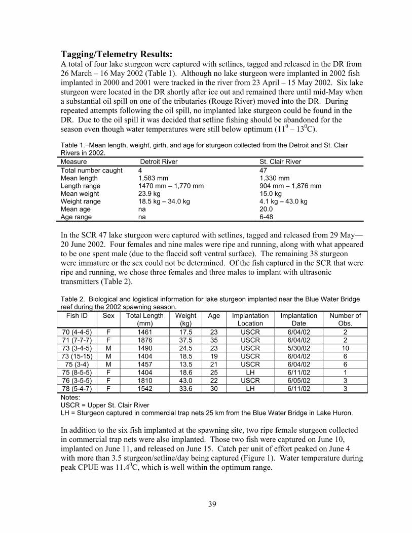
2002 Summary: During 2002 sampling was initiated on a spawning reef located near the Blue Water Bridge in the St. Clair River (Port Huron, MI). Sampling on the Detroit River continued for a fourth season. Using baited setlines 47 lake sturgeon were captured in the St. Clair River and four in Detroit River. All fish were tagged and released at the capture location. All fish captured on the Detroit River were initial captures. One fish captured on the St. Clair River was recaptured 20 days after initially being marked. Three of the fish captured were previously marked by other agencies. Ultrasonic transmitters were implanted in six ripe and running fish captured near the spawning reef on the St. Clair River. In addition, two fish captured approximately 25 km out in Lake Huron by commercial fishers were implanted. Movement data was collected throughout the spawning period in the St. Clair River and then periodically thereafter until October 2002. Six fish moved into Lake Huron after water temperatures reached 160C and two fish migrated downriver or into Lake St. Clair. Movement data helped identify critical habitats used during spawning including approximately 59 ha of clean cobble/gravel substrate downriver from the Blue Water Bridge near Port Huron, Michigan. Twenty-one year classes were represented in the catch from the St. Clair River and ranged in age from 6 – 48 years old. Sex of the fish included nine males and four females and 34 immature/undetermined. The Alpena FRO has been working in the Huron/Erie Corridor (HEC) since 1994. The tagging/telemetry study in the St. Clair River (SCR) was funded by National Fish and Wildlife Foundation (Project no. 2001-005-008) through December 2002. Great Lakes Fishery Trust Genetics Project has funded the collection of lake sturgeon from the Detroit River (DR) since 2001. Work on these projects has involved cooperation with several agencies including; Michigan Department of Natural Resources Mt Clemens Fishery Research Station, US Geological Survey Great Lakes Science Center, Ontario Ministry of Natural Resources Upper Great Lakes Management Unit, Central Michigan University, Purdy Fisheries Incorporated, and Detroit Edison. The objectives of this study are (1) to provide genetic material from populations of lake sturgeon spawning in the Detroit and St. Clair Rivers to aid in determining differences between the Great Lakes populations (2) determine movement patterns of lake sturgeon to identify critical spawning habitats and habitats essential during non-spawning periods, (3) collect baseline information about the populations spawning in the HEC including; abundance, age, growth, and sex ratios.
39
Tagging/Telemetry Results: A total of four lake sturgeon were captured with setlines, tagged and released in the DR from 26 March – 16 May 2002 (Table 1). Although no lake sturgeon were implanted in 2002 fish implanted in 2000 and 2001 were tracked in the river from 23 April – 15 May 2002. Six lake sturgeon were located in the DR shortly after ice out and remained there until mid-May when a substantial oil spill on one of the tributaries (Rouge River) moved into the DR. During repeated attempts following the oil spill, no implanted lake sturgeon could be found in the DR. Due to the oil spill it was decided that setline fishing should be abandoned for the season even though water temperatures were still below optimum (110 – 130C). Table 1.−Mean length, weight, girth, and age for sturgeon collected from the Detroit and St. Clair Rivers in 2002. Measure Detroit River St. Clair River Total number caught 4 47 Mean length 1,583 mm 1,330 mm Length range 1470 mm – 1,770 mm 904 mm – 1,876 mm Mean weight 23.9 kg 15.0 kg Weight range 18.5 kg – 34.0 kg 4.1 kg – 43.0 kg Mean age na 20.0 Age range na 6-48 In the SCR 47 lake sturgeon were captured with setlines, tagged and released from 29 May—20 June 2002. Four females and nine males were ripe and running, along with what appeared to be one spent male (due to the flaccid soft ventral surface). The remaining 38 sturgeon were immature or the sex could not be determined. Of the fish captured in the SCR that were ripe and running, we chose three females and three males to implant with ultrasonic transmitters (Table 2). Table 2. Biological and logistical information for lake sturgeon implanted near the Blue Water Bridge reef during the 2002 spawning season.
Fish ID Sex Total Length (mm)
Weight (kg)
Age Implantation Location
Implantation Date
Number of Obs.
70 (4-4-5) F 1461 17.5 23 USCR 6/04/02 2 71 (7-7-7) F 1876 37.5 35 USCR 6/04/02 2 73 (3-4-5) M 1490 24.5 23 USCR 5/30/02 10 73 (15-15) M 1404 18.5 19 USCR 6/04/02 6 75 (3-4) M 1457 13.5 21 USCR 6/04/02 6
75 (8-5-5) F 1404 18.6 25 LH 6/11/02 1 76 (3-5-5) F 1810 43.0 22 USCR 6/05/02 3 78 (5-4-7) F 1542 33.6 30 LH 6/11/02 3 Notes: USCR = Upper St. Clair River LH = Sturgeon captured in commercial trap nets 25 km from the Blue Water Bridge in Lake Huron. In addition to the six fish implanted at the spawning site, two ripe female sturgeon collected in commercial trap nets were also implanted. Those two fish were captured on June 10, implanted on June 11, and released on June 15. Catch per unit of effort peaked on June 4 with more than 3.5 sturgeon/setline/day being captured (Figure 1). Water temperature during peak CPUE was 11.40C, which is well within the optimum range.
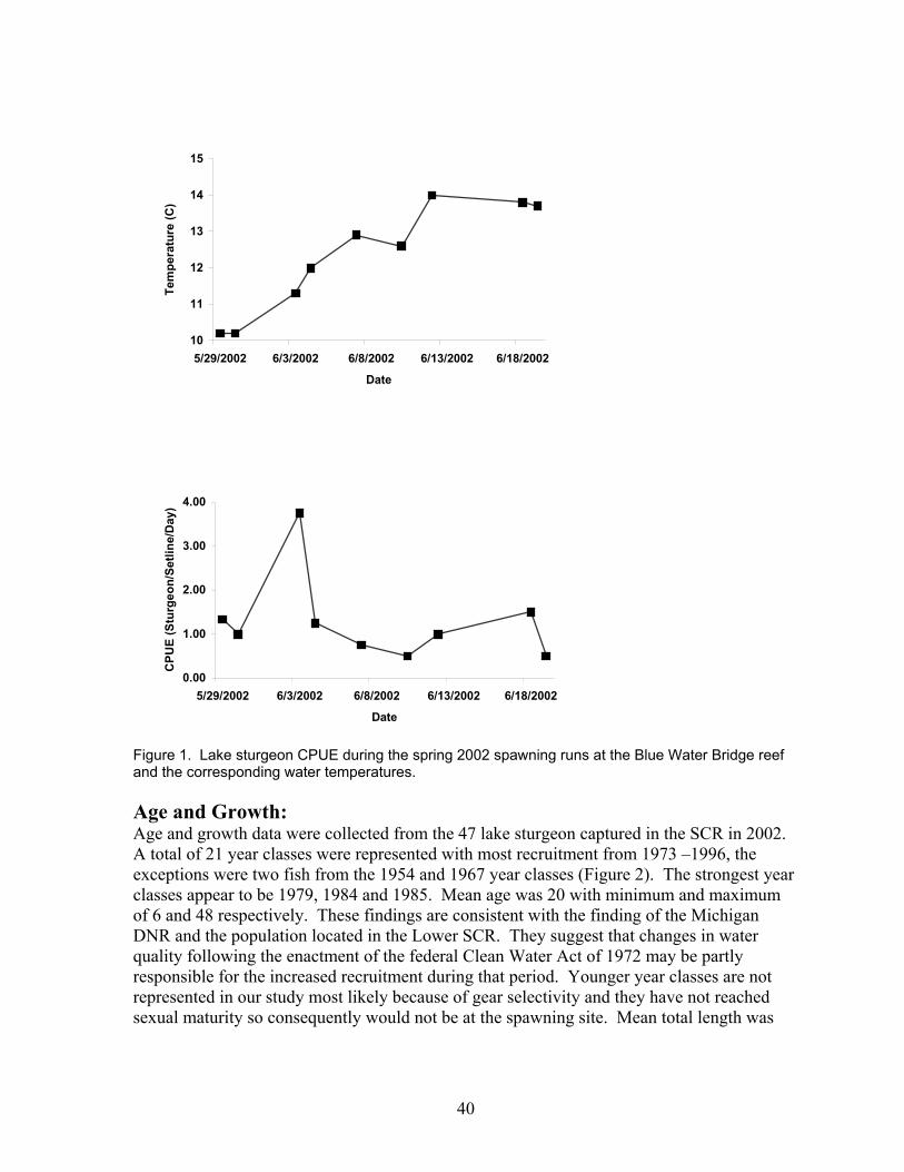
40
Figure 1. Lake sturgeon CPUE during the spring 2002 spawning runs at the Blue Water Bridge reef and the corresponding water temperatures. Age and Growth: Age and growth data were collected from the 47 lake sturgeon captured in the SCR in 2002. A total of 21 year classes were represented with most recruitment from 1973 –1996, the exceptions were two fish from the 1954 and 1967 year classes (Figure 2). The strongest year classes appear to be 1979, 1984 and 1985. Mean age was 20 with minimum and maximum of 6 and 48 respectively. These findings are consistent with the finding of the Michigan DNR and the population located in the Lower SCR. They suggest that changes in water quality following the enactment of the federal Clean Water Act of 1972 may be partly responsible for the increased recruitment during that period. Younger year classes are not represented in our study most likely because of gear selectivity and they have not reached sexual maturity so consequently would not be at the spawning site. Mean total length was
10
11
12
13
14
15
5/29/2002 6/3/2002 6/8/2002 6/13/2002 6/18/2002
Date
Tem
pera
ture
(C)
0.00
1.00
2.00
3.00
4.00
5/29/2002 6/3/2002 6/8/2002 6/13/2002 6/18/2002
Date
CPU
E (S
turg
eon/
Setli
ne/D
ay)

41
1,330 mm and is attained by age 19. Minimum and maximum total lengths were 904 and 1,876 respectively.
0
1
2
3
4
5
6
2000 1995 1990 1985 1980 1975 1970 1965 1960 1955 1950
Year Class
Num
ber o
f Fis
h
Figure 2. Number of lake sturgeon from each year-class captured with setlines in the St. Clair River in 2002 (n=42). Ages based on pectoral fin ray section interpretation. Telemetry Results: The time required to retrieve setlines each day prevented us from conducting extensive searches and locating each fish once they moved outside of the spawning area. On 5 June 2002, the 6 sturgeon that were implanted in the river were still located near the spawning reef as well as one fish that had been implanted on the DR in May 2001. Water temperatures at the reef on 5 June were at 11.80C. On 6 and 7 June one fish implanted at the reef and the fish from the DR were located in an area behind a shipwreck located just upriver from the bridge. Water temperatures were 12 and 130C respectively. Fish were not tracked on 8 and 9 June. By 10 June 2002, water temperature was still at 13.00C. Three fish from the Port Huron Reef and the DR fish were still near the spawning reef but were in areas where underwater obstructions caused an eddy or areas of reduced flow. By 12 June 2002 we reduced effort at the Blue Water Bridge from four setlines/day to two. The extra setlines were deployed at Fawn Island on 12 June 2002, and at the Mooretown gravel docks in Ontario on 13 June 2002 (Figure 3). Both sites were reputed to be historical spawning locations. Water temperature during those two sets was past the peak (> 14.00C) consequently only one fish was captured at each site. We continued to deploy setlines at the Port Huron site and on 19 June 2002, a male sturgeon implanted 30 May 2002 was recaptured. Biological information collected revealed that the fish had lost 0.5kg of body weight, probably due to spawning. After a torn suture was replaced the fish was released.
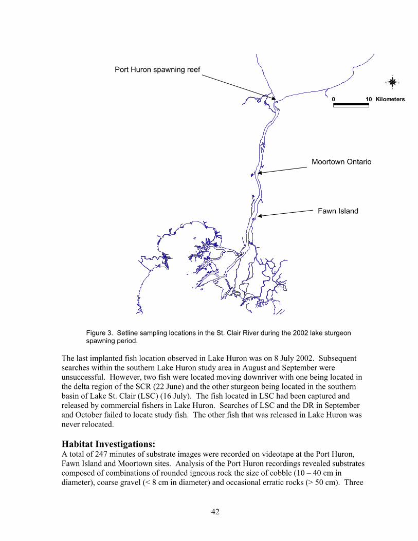
42
0 10 Kilometers
N
EW
S
Figure 3. Setline sampling locations in the St. Clair River during the 2002 lake sturgeon spawning period.
The last implanted fish location observed in Lake Huron was on 8 July 2002. Subsequent searches within the southern Lake Huron study area in August and September were unsuccessful. However, two fish were located moving downriver with one being located in the delta region of the SCR (22 June) and the other sturgeon being located in the southern basin of Lake St. Clair (LSC) (16 July). The fish located in LSC had been captured and released by commercial fishers in Lake Huron. Searches of LSC and the DR in September and October failed to locate study fish. The other fish that was released in Lake Huron was never relocated. Habitat Investigations: A total of 247 minutes of substrate images were recorded on videotape at the Port Huron, Fawn Island and Moortown sites. Analysis of the Port Huron recordings revealed substrates composed of combinations of rounded igneous rock the size of cobble (10 – 40 cm in diameter), coarse gravel (< 8 cm in diameter) and occasional erratic rocks (> 50 cm). Three
Port Huron spawning reef
Fawn Island
Moortown Ontario
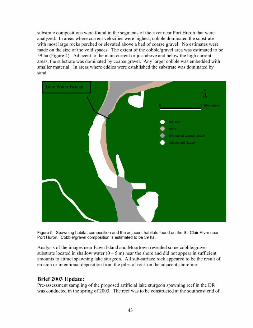
43
substrate compositions were found in the segments of the river near Port Huron that were analyzed. In areas where current velocities were highest, cobble dominated the substrate with most large rocks perched or elevated above a bed of coarse gravel. No estimates were made on the size of the void spaces. The extent of the cobble/gravel area was estimated to be 59 ha (Figure 4). Adjacent to the main current or just above and below the high current areas, the substrate was dominated by coarse gravel. Any larger cobble was embedded with smaller material. In areas where eddies were established the substrate was dominated by sand.
0 1 Kilometers
N
No Data
Sand
Embedded Coarse Gravel
Cobble and Gravel
Figure 5. Spawning habitat composition and the adjacent habitats found on the St. Clair River near Port Huron. Cobble/gravel composition is estimated to be 59 ha. Analysis of the images near Fawn Island and Moortown revealed some cobble/gravel substrate located in shallow water (0 – 5 m) near the shore and did not appear in sufficient amounts to attract spawning lake sturgeon. All sub-surface rock appeared to be the result of erosion or intentional deposition from the piles of rock on the adjacent shoreline. Brief 2003 Update: Pre-assessment sampling of the proposed artificial lake sturgeon spawning reef in the DR was conducted in the spring of 2003. The reef was to be constructed at the southeast end of
Blue Water Bridge

44
Belle Isle near the Fleming Channel during the fall of 2003. However, delays in funding and the permit process pushed the construction back until late spring of 2004. Post-assessment will continue in the spring of 2005. Setlining for adult lake sturgeon in the upper SCR continued in the spring of 2004 with 58 fish captured in six days of sampling. No new lake sturgeon were implanted in 2003 however, movement data was collected from two fish implanted in 2002 that returned during the spawning period. Blood and gamete samples, were collected from lake sturgeon captured on setlines in the spring of 2003 by researches from USGS Great Lakes Science Center and The Ohio State University. In September Alpena FRO working with researchers from Michigan DNR, Ontario MNR and USGS began a rapid assessment of the entire SCR for the presence of juvenile lake sturgeon (ages 0 – 5). Sampling ended in early October due to inclement weather but will continue during summer 2004. Thirty-five of over 120 potential nursery areas have been sampled to date.
45
U.S. Geological Survey Great Lakes Science Center Contact: Bruce Manny E-mail: [email protected]
USGS Lake Sturgeon Research in the Huron-Erie Corridor in 2002 The U.S. Geological Survey surveyed with side scan sonar, underwater TV, and limnological equipment one known lake sturgeon spawning site (Zug Island) and three suspected sturgeon spawning sites that were identified in 2001 in the Detroit River by Nate Caswell of the U.S. Fish and Wildlife Service (USFWS) with ultrasonic telemetry of two spawning-ready males. USGS also surveyed eight sites identified by USGS and the U.S. Army Corps of Engineers SeaWall Reconnaissance Study as potential sites for construction of sturgeon spawning habitat at the toe of any new seawall installed at those sites. All these sites possessed relatively high (>0.5 m/s) water current velocity and a water depth of about 10 m. In April 2002 in collaboration with USFWS, USGS placed egg traps on the river bottom at the one known and three suspected sturgeon spawning sites and listened with telemetry equipment at 64 stations throughout the Detroit River for 20 adult sturgeon implanted by Nate Caswell with ultrasonic transmitters in 2000 and 2001. Just prior to a massive spill of waste oil and diesel fuel (> million liters) in the Rouge River just downstream of Zug Island on April 10-12, 2002, several adult sturgeon were located in the Detroit River, including Number 567, upstream of the spill, in mid-channel, offshore of Zug Island. Immediately after the oil spill, only the latter sturgeon was located in the Detroit River. No sturgeon eggs were collected on egg traps in the Detroit River in 2002 during the interval of April 10-May 30 when water temperature was 9.5 to 15.3°C. However, sucker eggs were collected at Zug Island and at one of the suspected sturgeon spawning sites (Ballards Reef Light) on May 16, 2002 and smaller diameter fish eggs were collected in traps at another suspected sturgeon spawning site (Livingstone Channel Light) on May 30, 2002. In July 2002, USGS scientists performed intensive surveys of four candidate sites in the upper Detroit River and selected one site for construction of three sturgeon spawning beds consisting of 8-16 inch broken limestone, metamorphic gravel and cobble, and coal cinders, respectively. Southeast Belle Isle in the Fleming Channel was selected as the site for the Belle Isle/Detroit River Sturgeon Habitat Restoration, Monitoring, and Education Project because it is constantly bathed by high quality water coming down the shipping channel from Lake Huron. Deflection of this flow off the head of Belle Isle generates water velocity > 0.5 m/s on site. Water depth on site (7-9 m) is greater than that colonized by submersed aquatic plants in the Detroit River (0-6 m). Lastly, the site is accessible to adult lake sturgeon and less than a kilometer from a historic, reputed lake sturgeon spawning site near Peche Island. Design of the beds largely follows that of lake sturgeon spawning habitat constructed over the past 20 years on the Fox and Wolf Rivers near Lake Winnebago in Wisconsin by Sturgeon for Tomorrow and Shadows of the Wolf organizations in collaboration with the

46
Wisconsin Department of Natural Resources and the Great Lakes Water Institute at the University of Wisconsin. This collaborative demonstration project is funded by the NOAA Coastal Restoration Grant Program and the Great Lakes Fishery Trust. It includes construction, scientific monitoring, and education elements and exists as a result of a partnership among the Michigan Department of Environmental Quality; Michigan Department of Natural Resources-Fisheries Division; City of Detroit Recreation Department; Michigan Sea Grant College Program-University of Michigan and Michigan State University; DTE Energy Corporation; SmithGroup JJR; Detroit River Remedial Action Team; Friends of the Detroit River; Friends of Belle Isle; Greater Detroit American Heritage River Initiative; Wyandot of Anderdon Nation; Sturgeon for Tomorrow (Black Lake, Michigan Chapter); Essex Region Conservation Authority; Ontario Ministry of the Environment; Ontario Ministry of Natural Resources; U.S. Army Corps of Engineers, U.S. Fish and Wildlife Service-Alpena Fisheries Resource Office; and the U.S. Geological Survey. Products of Interest in 2002: Nichols, S.J. et al. 2002. Assessment of lake sturgeon (Acipenser fulvescens) spawning
effors in the lower St. Clair River, Michgian. Journal of Great Lakes Research 29(3):383-391.
Manny, B.A. and G.W. Kennedy. 2002. Known lake sturgeon (Acipenser fulvescens)
spawning habitat in the channel between Lakes Huron and Erie in the Laurentian Great Lakes. Journal of Applied Ichthyology 18:486-490.
47
U.S. Geological Survey Great Lakes Science Center Contact: Richard Quintal E-mail: [email protected]
A Non-Lethal Procedure for the Determination of Organic Contaminant Concentrations in Lake Sturgeon Introduction: Lake sturgeon (Acipenser fulvescens) is listed as threatened and is protected in Michigan waters of the Great Lakes under the Michigan Endangered Species Act of 1994 and is listed as Special Concern, Threatened, or Endangered in all of the eight Great Lakes states. Protection under the Michigan Endangered Species Act has made it impossible to incorporate sturgeon into routine contaminant monitoring programs that typically require the sacrifice of the fish but which produce data critical to a better understanding of a species’ overall health. Because of this protection, there is very little data published enumerating the contaminant levels in sturgeon. To this end, a non-lethal method has been developed to sample lake sturgeon tissue. This method, once deployed, will provide invaluable contaminant data without harming the species’ population or violating the Endangered Species Act. The procedure involves the use of a 0.5” (12.7 mm) i.d. steel tube, sharpened at one end, to take a core sample through the fish. The core sample is taken at the midpoint of the dorsal fin on the left side. A small incision makes it easier to start the sampling tube into the dorsal surface. After this, the tube is driven straight down through the tail and ventral skin. No primary closure is required. The method is suitable for most organochlorine contaminant analysis and has applicability to other species of sturgeon. Because the method employs a standardized location for sampling, it may not be applicable to non-acipenserid species. Its use should yield 4-6 grams of tissue, sufficient for most modern instrumentation to quantify contaminant levels. Specific tissues included muscle, gonad, liver, and blood. The analytes included 80 PCB congeners including the most toxic planar congeners, 21 pesticides, and Toxaphene. Methods: For this study, muscle, blood, liver, and gonads were considered for sampling purposes. We looked for the best location to collect each of these tissues and considered the ramifications of each. After determining the appropriate tissue, experiments were run to determine the tool and method that would yield the most tissue while posing the least risk of mortality and sample cross-contamination. Efforts quickly focused on a tunneling device of standard dimension to ensure comparable samples. Samples of ten grams, standard for our GC/MS contaminants protocols, were compared with one-gram samples to find out if lower mass samples would pose detection limit problems. Field tests occurred on 11 June 2002 to determine if the sampling method was indeed non-lethal. We used 4 sturgeon as experimental fish and two for control fish.
48
The following analytes were quantitated: 80 PCB congeners, Total PCB, Pentachlorobenzene, alpha-HCH (Hexachlorcyclohexane), Hexachlorobenzene, PCPME (Pentachlorophenylmethylether), Lindane, Aldrin, Dachtal, Octachlorostyrene, b-Heptachlor Epoxide, Oxychlordane, trans-Chlordane, cis-Chlordane, trans-Nonachlor, cis-Nonachlor, Dieldrin, Endrin, pp’-DDD, pp’-DDE, pp’-DDT, Photo-Mirex, Mirex, the hexa through deca-chlorinated Toxaphene homologues, and Total Toxaphene. Results: A total of 15 fish were sampled for various tissues during this study. In some cases, an emerging issue contaminant, Polybrominated Diphenyl Ethers (PBDEs) is mentioned as points of interest although analyses of this chemical group were limited and data are not provided. Lake Michigan 1999: Chemical analyses demonstrated that significant amounts of chlorinated hydrocarbons were accumulated in the blood and liver of the sturgeon collected near Manistee in 1999. In spite of the fact that the age, gender, and length of collected fishes were different, their PCB concentrations in the liver were similar, differing no more than 10% from 850 ng/g to 950 ng/g. The margin in blood samples was somewhat greater, varying by 20% from 800 ng/g to 980 ng/g. Nevertheless, these concentrations are much lower than lake trout sampled at approximately the same time and location where whole fish and liver had values of about 1,800 ng/g and 7,500 ng/g respectively. It is important to mention that in contrast with PCB accumulation by other fish species in Lake Michigan, the distribution of congeners in lake sturgeon is relatively more even. The highest abundance was found in congeners #153 and #163, corresponding to lake trout from Lake Michigan, but the next highest congeners were #118, #84, #66, and #71 which do not contribute significantly to lake trout or smelt contaminant loads. There are insignificant amounts of the toxic planar congeners. Congener #126 did not exceed 0.5 ng/g in sturgeon whereas it tends to be 10 ng/g in lake trout from the same location. In the pesticide category, there is great variability in the liver concentrations of DDE, Toxaphene, Mirex, and Total Chlordanes, depending on age and gender however, the concentrations did not vary greatly in the blood samples. The octa and nona-chlorinated Toxaphene homologues showed a greater relative abundance in lake sturgeon as compared to lake trout, which typically have more of the hepta-chlorinated homologues. Emerging issue contaminants, especially Polybrominated Diphenyl Ether (PBDE) #47 and #99 showed very small concentrations in Manistee sturgeon at 1 ng/g and 0.2 ng/g respectively as compared to lake trout. In contrast to lake trout, where concentrations of the various categories is very consistent, PBDE concentrations in sturgeon exceed the concentrations of some of the more global contaminants, specifically Chlordanes, HCHs, Hexachlorobenzene, and most industrial organochlorines. Lake St. Clair 2001: A different picture of contaminants was observed in 2001 Lake St. Clair samples. PCB concentrations were much lower in these fish as compared to Lake Michigan fish. The concentrations for liver, testes, and muscle were 400-600 ng/g, ~650
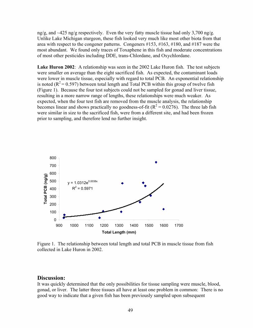
49
ng/g, and ~425 ng/g respectively. Even the very fatty muscle tissue had only 3,700 ng/g. Unlike Lake Michigan sturgeon, these fish looked very much like most other biota from that area with respect to the congener patterns. Congeners #153, #163, #180, and #187 were the most abundant. We found only traces of Toxaphene in this fish and moderate concentrations of most other pesticides including DDE, trans-Chlordane, and Oxychlordane. Lake Huron 2002: A relationship was seen in the 2002 Lake Huron fish. The test subjects were smaller on average than the eight sacrificed fish. As expected, the contaminant loads were lower in muscle tissue, especially with regard to total PCB. An exponential relationship is noted (R2 = 0.597) between total length and Total PCB within this group of twelve fish (Figure 1). Because the four test subjects could not be sampled for gonad and liver tissue, resulting in a more narrow range of lengths, these relationships were much weaker. As expected, when the four test fish are removed from the muscle analysis, the relationship becomes linear and shows practically no goodness-of-fit (R2 = 0.0276). The three lab fish were similar in size to the sacrificed fish, were from a different site, and had been frozen prior to sampling, and therefore lend no further insight.
y = 1.0312e0.0038x
R2 = 0.5971
0
100
200
300
400
500
600
700
800
900 1000 1100 1200 1300 1400 1500 1600 1700
Total Length (mm)
Tota
l PC
B (n
g/g)
Figure 1. The relationship between total length and total PCB in muscle tissue from fish collected in Lake Huron in 2002. Discussion: It was quickly determined that the only possibilities for tissue sampling were muscle, blood, gonad, or liver. The latter three tissues all have at least one problem in common: There is no good way to indicate that a given fish has been previously sampled upon subsequent
50
recapture. Repeated sampling of the same fish would not yield viable information on the health of the species and may in fact endanger the health of the individual. Attention should be paid to water quality before using this method. Elevated levels of bacteria may preclude the use of the method due to the increased chance of infection. In general, if there are no restrictions on swimming or fishing in affect because of bacteria levels, there should be no risk to the fish. No remarkable differences were noted between the condition of the fish on 27 June 2002 and the pre-test condition in terms of their behavior and overall health. Minor cellulitis and redness was noted in all cases at the time of release; however, none of the fish appeared to have a serious infection and the wounds appeared to be healing. Blood loss during the procedure was approximately 10cc and was not considered significant. Hemorrhaging ceased within minutes of returning the fish to the holding tank. The method is quick and less invasive than the gonad and liver techniques. It had very little effect on the fish’s ability to swim in the holding tanks and should heal within weeks. Conclusion: The method developed for this study is in fact non-lethal. Furthermore, the results obtained from the samples can be used to monitor organic contaminants in lake sturgeon but there are two hurdles to overcome for any such monitoring project to be effective. First, the anesthesia delivery method must be refined so that it is less cumbersome. Second, better communication needs to be developed between agencies so that the same fish are not caught and sampled repeatedly. This would yield misleading or useless data. Each entity that tags fish in the Great Lakes uses a tag that best suits there own preferences. Using a standardized tag for this methodology would solve the problem of identifying sampled fish however; researchers would likely be hesitant to use a tag significantly different from the kind to which they are already accustomed. A basin-wide database for this information would be most useful. As for the method, researchers are advised to tag fish but no specific device is indicated. Tag numbers for this study are given in Table 1 so that these fish can be identified upon subsequent capture.
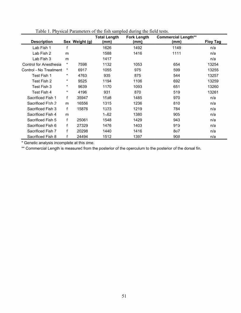
51
Table 1. Physical Parameters of the fish sampled during the field tests.
Description Sex Weight (g) Total Length
(mm) Fork Length
(mm) Commercial Length**
(mm) Floy Tag Lab Fish 1 f 1626 1492 1149 n/a Lab Fish 2 m 1588 1416 1111 n/a Lab Fish 3 m 1417 n/a
Control for Anesthesia * 7598 1132 1053 654 13254 Control - No Treatment * 6917 1055 975 599 13255
Test Fish 1 * 4763 935 875 544 13257 Test Fish 2 * 9525 1194 1106 692 13259 Test Fish 3 * 9639 1170 1093 651 13260 Test Fish 4 * 4196 931 870 519 13261
Sacrificed Fish 1 f 35947 1598 1485 970 n/a Sacrificed Fish 2 m 16556 1315 1236 810 n/a Sacrificed Fish 3 f 15876 1323 1219 784 n/a Sacrificed Fish 4 m 1462 1380 905 n/a Sacrificed Fish 5 f 25061 1548 1429 943 n/a Sacrificed Fish 6 f 27329 1476 1403 919 n/a Sacrificed Fish 7 f 20298 1440 1416 867 n/a Sacrificed Fish 8 f 24494 1512 1397 908 n/a
* Genetic analysis incomplete at this time. ** Commercial Length is measured from the posterior of the operculum to the posterior of the dorsal fin.
Poste
Anterior
Entrance Exit
52
The Ohio State University School of Natural Resources Contact: Julia Froschauer and Konrad Dabrowski E-mail: [email protected] [email protected]
Report on Lake Sturgeon Activities for 2002 The Ohio State University, School of Natural Resources Aquaculture Laboratory began sampling lake sturgeon on the Detroit River and the St. Clair River in the spring of 2002. Visiting scholar Andrzej Ciereszko coordinated sampling efforts with the U.S. Fish and Wildlife Service Alpena Fisheries Resource Office (FRO) in May and June of 2002. Because of unusual weather events, the spawning of the lake sturgeon was difficult to predict. During several trips to the Detroit River only a few lake sturgeon were caught. None of the lake sturgeon captured in the Detroit River were spawning, consequently no gametes were collected. However collection efforts on the St. Clair River were more successful. Male and female fish were caught and we were able to collect samples of milt and eggs for analysis at the aquaculture laboratory at the Ohio State University. Samples of milt were cryopreserved and are now stored in cryofreezers. Working with the Alpena FRO and the Ontario Ministry of Natural Resources we were able to collect morphological data, blood, and tissue samples from lake sturgeon caught by Purdy Fisheries in St. Clair River/Lake Huron waters in Canada. Julia Froschauer processed the biological samples collected in the summer of 2002 in the aquaculture laboratory. She has analyzed blood, tissues, egg, and seminal plasma samples for vitamin C (ascorbic acid) concentrations and liver and blood samples for vitamin E concentrations (Table 1). Methods used were as described by Dabrowski and Hinterleitner (1989) and Moreau and Dabrowski (2003). Results are presented in Table 1. Both of these vitamins have been shown to have an impact on fish reproduction (Dabrowski and Ciereszko 2001; Dabrowski 2003). Data regarding the eggs and seminal plasma collected and ascorbic acid concentrations are shown in Table 2.
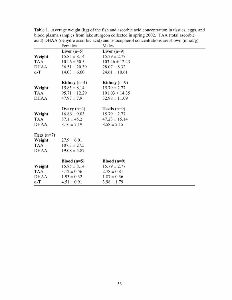
53
Table 1. Average weight (kg) of the fish and ascorbic acid concentration in tissues, eggs, and blood plasma samples from lake sturgeon collected in spring 2002. TAA (total ascorbic acid) DHAA (dehydro ascorbic acid) and α-tocopherol concentrations are shown (nmol/g). Females Males
Liver (n=5) Liver (n=9) Weight 15.85 ± 8.14 15.79 ± 2.77 TAA 101.6 ± 50.5 103.46 ± 12.23 DHAA 36.51 ± 20.39 28.07 ± 8.32 α-T 14.03 ± 6.60 24.61 ± 10.61 Kidney (n=4) Kidney (n=9) Weight 15.85 ± 8.14 15.79 ± 2.77 TAA 95.71 ± 12.29 101.03 ± 14.35 DHAA 47.97 ± 7.9 32.98 ± 11.09
Ovary (n=4) Testis (n=9) Weight 16.86 ± 9.03 15.79 ± 2.77 TAA 87.1 ± 45.2 47.23 ± 15.14 DHAA 8.16 ± 7.19 8.58 ± 2.15 Eggs (n=7) Weight 27.9 ± 6.01 TAA 107.3 ± 27.5 DHAA 19.08 ± 5.87
Blood (n=5) Blood (n=9) Weight 15.85 ± 8.14 15.79 ± 2.77 TAA 3.12 ± 0.56 2.78 ± 0.81 DHAA 1.93 ± 0.32 1.87 ± 0.36 α-T 4.51 ± 0.91 3.98 ± 1.79
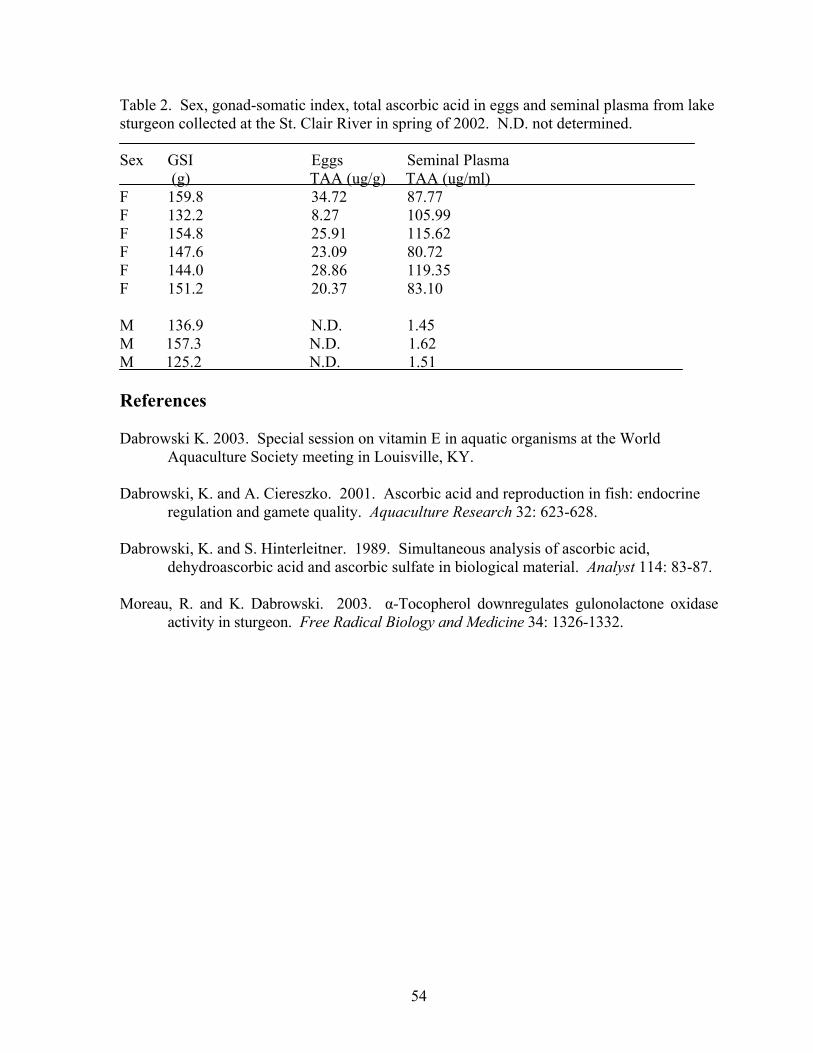
54
Table 2. Sex, gonad-somatic index, total ascorbic acid in eggs and seminal plasma from lake sturgeon collected at the St. Clair River in spring of 2002. N.D. not determined. Sex GSI Eggs Seminal Plasma (g) TAA (ug/g) TAA (ug/ml) F 159.8 34.72 87.77 F 132.2 8.27 105.99 F 154.8 25.91 115.62 F 147.6 23.09 80.72 F 144.0 28.86 119.35 F 151.2 20.37 83.10 M 136.9 N.D. 1.45 M 157.3 N.D. 1.62 M 125.2 N.D. 1.51 References Dabrowski K. 2003. Special session on vitamin E in aquatic organisms at the World
Aquaculture Society meeting in Louisville, KY. Dabrowski, K. and A. Ciereszko. 2001. Ascorbic acid and reproduction in fish: endocrine
regulation and gamete quality. Aquaculture Research 32: 623-628. Dabrowski, K. and S. Hinterleitner. 1989. Simultaneous analysis of ascorbic acid,
dehydroascorbic acid and ascorbic sulfate in biological material. Analyst 114: 83-87. Moreau, R. and K. Dabrowski. 2003. α-Tocopherol downregulates gulonolactone oxidase
activity in sturgeon. Free Radical Biology and Medicine 34: 1326-1332.
55
LAKE ERIE
Ohio Division of Wildlife Sandusky Fisheries Research Station Contact: Chris Vandergoot E-mail: [email protected]
Conservation Tactics for Endangered Lake Sturgeon There were 16 reported lake sturgeon sightings in 2002 within Ohio waters. Ten of the reported sightings were from commercial fishermen; the remaining 6 were from recreational fisherman, predominately while fishing for yellow perch. Total lengths ranged between 394 mm (15.5 inches) and 1295 mm (51 inches). Similar to sturgeon sightings in the past the majority of fish were observed around the Bass Islands and western basin. Lakewide, 4 dead lake sturgeon were reported by the New York State Department of Conservation, all of which were found by lakeshore residents.
56
NIAGARA RIVER
U.S. Fish and Wildlife Service Lower Great Lakes Fishery Resources Office Contact: Emily Zollweg E-mail: [email protected]
In 2002, the LGLFRO continued the lake sturgeon sampling in the lower Niagara River. This lake sturgeon project was in cooperation with the State University of New York - College at Brockport for 1998-2000. Complete analysis of the early years of this study is available in a thesis publication (Hughes 2002). The overall goal of our study is to identify key spawning and feeding habitats in the river in order to better manage, protect, and enhance the lake sturgeon population in the lower Niagara River. The research objectives of our study are to: (1) assess the population of lake sturgeon in the lower Niagara River by collecting and analyzing age, growth, and abundance data, (2) compare the movements of adult and juvenile lake sturgeon in the lower Niagara River, and (3) identify potential spawning, feeding, and nursery habitats in the lower Niagara River and compare utilization of these habitats between adult and juvenile lake sturgeon. In 2002, the lower Niagara River was sampled for lake sturgeon from April 29-July 25 using baited setlines. Setlines were constructed according to the methods of Thomas and Haas (1999). Forty lake sturgeon were captured in the lower river and in Lake Ontario near the mouth. No recaptures were recorded in 2002. Size and age composition of the catch were similar to previous years. Year class analysis indicates that 1993-1996 were relatively good recruitment years (Figure 1). It will be important to notice whether these fish remain in the area and return to attempt to spawn in the next few years.
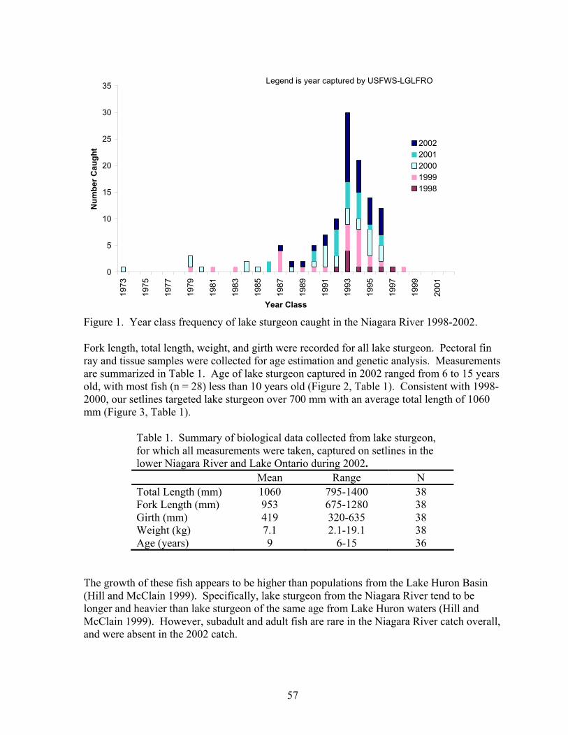
57
0
5
10
15
20
25
30
35
1973
1975
1977
1979
1981
1983
1985
1987
1989
1991
1993
1995
1997
1999
2001
Year Class
Num
ber C
augh
t 20022001200019991998
Legend is year captured by USFWS-LGLFRO
Figure 1. Year class frequency of lake sturgeon caught in the Niagara River 1998-2002.
Fork length, total length, weight, and girth were recorded for all lake sturgeon. Pectoral fin ray and tissue samples were collected for age estimation and genetic analysis. Measurements are summarized in Table 1. Age of lake sturgeon captured in 2002 ranged from 6 to 15 years old, with most fish (n = 28) less than 10 years old (Figure 2, Table 1). Consistent with 1998-2000, our setlines targeted lake sturgeon over 700 mm with an average total length of 1060 mm (Figure 3, Table 1).
Table 1. Summary of biological data collected from lake sturgeon, for which all measurements were taken, captured on setlines in the lower Niagara River and Lake Ontario during 2002. Mean Range N Total Length (mm) 1060 795-1400 38 Fork Length (mm) 953 675-1280 38 Girth (mm) 419 320-635 38 Weight (kg) 7.1 2.1-19.1 38 Age (years) 9 6-15 36
The growth of these fish appears to be higher than populations from the Lake Huron Basin (Hill and McClain 1999). Specifically, lake sturgeon from the Niagara River tend to be longer and heavier than lake sturgeon of the same age from Lake Huron waters (Hill and McClain 1999). However, subadult and adult fish are rare in the Niagara River catch overall, and were absent in the 2002 catch.
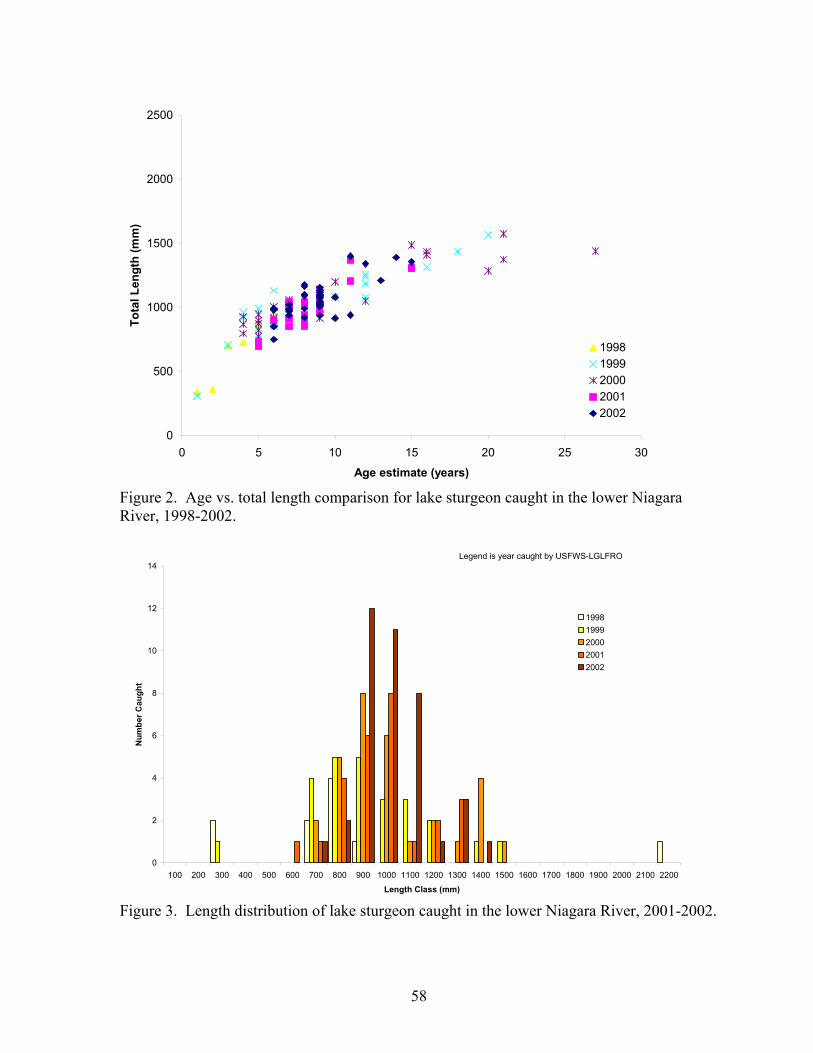
58
0
500
1000
1500
2000
2500
0 5 10 15 20 25 30
Age estimate (years)
Tota
l Len
gth
(mm
)
19981999200020012002
Figure 2. Age vs. total length comparison for lake sturgeon caught in the lower Niagara River, 1998-2002.
0
2
4
6
8
10
12
14
100 200 300 400 500 600 700 800 900 1000 1100 1200 1300 1400 1500 1600 1700 1800 1900 2000 2100 2200
Length Class (mm)
Num
ber C
augh
t
19981999200020012002
Legend is year caught by USFWS-LGLFRO
Figure 3. Length distribution of lake sturgeon caught in the lower Niagara River, 2001-2002.
59
Genesee River In a cooperative effort with New York State Department of Environmental Conservation (NYSDEC) Region 8, Avon and Endangered Species, and U.S. Geological Survey, Tunison Laboratory of Aquatic Science, we are determining the habitat suitability for, and the present utilization of lake sturgeon in the Genesee River below Rochester. This project is partially funded through grants from U. S. EPA- Great Lakes National Program Office. LGLFRO deployed 10-inch stretch gillnets in the river to catch adult lake sturgeon potentially migrating during the suspected spawning period. In addition, during the summer months (July and August), experimental gillnets were fished to capture young lake sturgeon in 1999-2000. No lake sturgeon were caught after 30 gillnet nights of effort in 1999-2001. According to the HSI for lake sturgeon (Threader et. al. 1998), suitable spawning habitat (0.5-2.5 m depth, 50-240 cm/s velocity, 10-18o C, and boulder/cobble substrate) was found below the lower falls. Sub-optimum juvenile habitat was found in the downstream areas of the river. The Rochester Embayment is listed as an Area of Concern, therefore the effects of chemical contamination on the suitability for lake sturgeon cannot be ignored. However, no water chemical analysis was done in 1999. In 2001, no mature, adult lake sturgeon were collected from the Niagara River for spawning purposes. Eggs were successfully collected and fertilized by the New York State Department of Environmental Conservation (NYSDEC) from one female from the St. Lawrence River. Eggs were transported to NYSDEC’s Oneida Lake hatchery (approx. 60,000), USFWS’ Pittsford National Fish Hatchery (approx. 10,000), USGS Great Lakes Science Center (unknown amount), and Kentucky State University (approx. 10,000). All eggs hatched, but after one day post-hatch, all fry had died at all facilities. The cause of the mortality has not been determined; however, it is expected the female did not have viable eggs; possibly due to contaminant loads. In 2002, we were not able to collect and spawn sturgeon from either the Niagara River or St. Lawrence River. We will continue attempting to acquire eggs from both the Niagara and St. Lawrence Rivers and obtain more than one individual female, and rear the fry at multiple hatcheries. Even if these precautions are taken in the future, there still is no guarantee of successfully producing juveniles. The only contingency plan we have for the unlikely event of total failure again is to annually delay the project until juveniles are successfully reared. Lake Sturgeon Sighting Program and Public Education Anecdotal information of lake sturgeon sightings has been reported by recreationalists and commercial fishermen since 1994. In 1998, we significantly increased our public outreach efforts. Lake sturgeon ‘Sighting Alert’ cards were distributed to marinas, bait shops and boat launches; posters were displayed in dive shops; LGLFRO web pages were created; and a ‘Sighting Alert’ notice was posted in the NY State Fishing Regulations Guide. In each sighting report, participants recorded general information regarding the sturgeon siting (date, time, location, number and size of fish) as well as habitat variables (depth, water temperature, substrate composition, and vegetative abundance). As a result of our increased educational effort, 86 reports of 120 lake sturgeon (in 7 water bodies) were filed by our office in 1998. In 1999, 77 reports of 119 lake sturgeon (in 16 water bodies) were recorded. The increase in
60
the number of water bodies where lake sturgeon were sighted in 1999 is likely due to NYSDEC stocking efforts and increased public awareness. All new water bodies reported in 1999 have received stocked lake sturgeon either directly into or in adjacent waters over the past three years. In 2001, sighting reports declined to 30 reports, the majority of which were Lake Erie shoreline mortalities. In 2002, sighting reports declined further to 6 reports. Two reports were from Lake Erie, one each from the upper and lower Niagara River, and two from the Oswegatchie River. References Hughes, T. C. 2002. Population characteristics, habitats, and movements of lake sturgeon
(Acipenser fulvescens) in the lower Niagara River. Master’s Thesis. State University of New York College at Brockport, Brockport, New York. 175 pp.
Thomas, M. V. and R. C. Haas. 1999. Capture of lake sturgeon with setlines in the St. Clair
River, Michigan. North American Journal of Fisheries Management 19:610-612. Hill, T. D. and J. R. McClain, editors. 1999. Activities of the Central Great Lakes Bi-
National Lake Sturgeon Group. USFWS, Alpena Fishery Resources Office, Alpena, Michigan. 63 pp.
Threader, R. W., R. J. Pope, and P. R. H. Schaap. 1998. Development of a habitat suitability
index model for lake sturgeon (Acipenser fulvescens). Ontario Hydro, Report No. H-07015.01-0012, Haley Station, Ontario, Canada. 143 pp.