2.0 environmental overview draft chapter
TRANSCRIPT
2-1
2.0 Environmental Overview Draft Chapter
2.1 Introduction
Any time Federal Aviation Administration (FAA) funding is used for airport development projects, an environmental
approval is required. As part of the environmental overview process, the FAA has issued orders 1050.1F and 5050.4B
to establish standardized guidelines for complying with the National Environmental Policy Act of 1969 (NEPA).
While the environmental overview itself will not satisfy all the NEPA requirements, it is a tool to be utilized as a
preliminary review of the environmental considerations that will be studied in detail during the NEPA process.
The purpose of the NEPA process is to identify, minimize, and mitigate potential environmental impacts as part of
the initial planning process. Any time preferred development alternatives are designed at The Ohio State University
Airport (KOSU), it is important to comply with the environmental overview process early on to determine the specific
level of environmental analysis that will be necessary for these developments before construction can begin. NEPA
provisions require federal agencies funding or approving a development proposal to make their decisions in a way
that will protect, restore, and enhance the environment by first understanding the potential impacts of a proposed
project.
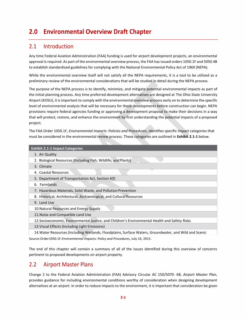
The FAA Order 1050.1F, Environmental Impacts: Policies and Procedures, identifies specific impact categories that
must be considered in the environmental review process. These categories are outlined in Exhibit 2.1-1 below.
Source: Order 1050.1F: Environmental Impacts: Policy and Procedures, July 16, 2015.
The end of this chapter will contain a summary of all of the issues identified during this overview of concerns
pertinent to proposed developments on airport property.
2.2 Airport Master Plans
Change 2 to the Federal Aviation Administration (FAA) Advisory Circular AC 150/5070- 6B, Airport Master Plan,
provides guidance for including environmental conditions worthy of consideration when designing development
alternatives at an airport. In order to reduce impacts to the environment, it is important that consideration be given
Exhibit 2.1-1 Impact Categories
1. Air Quality
2. Biological Resources (Including Fish, Wildlife, and Plants)
3. Climate
4. Coastal Resources
5. Department of Transportation Act, Section 4(f)
6. Farmlands
7. Hazardous Materials, Solid Waste, and Pollution Prevention
8. Historical, Architectural, Archaeological, and Cultural Resources
9. Land Use
10. Natural Resources and Energy Supply
11. Noise and Compatible Land Use
12. Socioeconomic, Environmental Justice, and Children’s Environmental Health and Safety Risks
13. Visual Effects (Including Light Emissions)
14. Water Resources (Including Wetlands, Floodplains, Surface Waters, Groundwater, and Wild and Scenic
Rivers
2-2
to these environmental issues. As development alternatives are designed through the planning process at KOSU, the
issues identified in this chapter should be incorporated into all design considerations from early on in the planning
process.
2.3 Level of Review
Upon determining that NEPA applies to a proposed action, the FAA will decide on the appropriate level of review.
The three levels of NEPA review are Categorical Exclusions (CATEX), Environmental Assessment (EA), and
Environmental Impact Statement (EIS). Each of the three types of review are described in the sections below in
further detail.
2.3.1 Categorical Exclusion (CATEX)
A CATEX is a category of actions that neither individually nor cumulatively effect the human environment in a
significant way and has no extraordinary circumstances, and thus neither an EA nor an EIS is required for these
categories of actions. A CATEX is not an exemption or a waiver from the NEPA review process. It is itself a level of
NEPA review. See Chapter 5 of Order 1050.1F for further information on CATEXs.
2.3.2 Environmental Assessment (EA)
An EA is used to determine if a proposed action has the potential to significantly impact the human environment.
An EA is a concise public document that briefly provides evidence and analysis for determining whether to prepare
an EIS or a Finding of No Significant Impact (FONSI). An EA must be prepared when the proposed action does not
normally require an EIS and does not fall within the scope of a CATEX or falls within the scope of a CATEX but has
extraordinary circumstances.
2.3.4 Extraordinary Circumstances
Extraordinary circumstances are situations which cause a normally categorically excluded action to have a significant
environmental impact that may require further analysis in the form of an EA or EIS. For all proposed actions receiving
FAA funding, extraordinary circumstances exist when the proposed action fulfills both of the following criteria even
if it otherwise would qualify under one or more CATEX categories (see 40 CFR § 1508.4, CEQ Regulations). (See
Exhibit 2.3.4-1.)
Exhibit 2.3.4-1: Extraordinary Circumstances
An extraordinary circumstance exists if a proposed action involves any of the following circumstances and has
the potential for a significant impact:
1. An adverse effect on cultural resources protected under the National Historic Preservation Act of 1966, as
amended, 54 U.S.C §300101 et seq.
2. An impact on properties protected under Section 4(f)
3. An impact on natural, ecological, or scenic resources of Federal, state, tribal or local significance
4. An impact on resources protected by the Fish and Wildlife Coordination Act, 16
U.S.C. §§ 661-667d, wetlands, floodplains, coastal zones, national marine sanctuaries, wilderness areas,
National Resource Conservation Service- designated prime and unique farmlands, energy supply and
natural resources, resources protected under the Wild and Scenic Rivers Act, 16 U.S.C. §§ 1271- 1287,
rivers or river segments listed on the Nationwide Rivers Inventory (NRI), and solid waste management.
5. A division or disruption of an established community, or a disruption of orderly, planned development, or
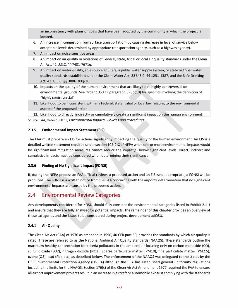
2-3
an inconsistency with plans or goals that have been adopted by the community in which the project is
located.
6. An increase in congestion from surface transportation (by causing decrease in level of service below
acceptable levels determined by appropriate transportation agency, such as a highway agency).
7. An impact on noise sensitive areas.
8. An impact on air quality or violations of Federal, state, tribal or local air quality standards under the Clean
Air Act, 42 U.S.C. §§ 7401-7671q.
9. An impact on water quality, sole source aquifers, a public water supply system, or state or tribal water
quality standards established under the Clean Water Act, 33 U.S.C. §§ 1251-1387, and the Safe Drinking
Act, 42. U.S.C. §§ 300f- 300j-26
10. Impacts on the quality of the human environment that are likely to be highly controversial on
environmental grounds. See Order 1050.1F paragraph 5- 3d(10) for specifics involving the definition of
“highly controversial”.
11. Likelihood to be inconsistent with any Federal, state, tribal or local law relating to the environmental
aspect of the proposed action.
12. Likelihood to directly, indirectly or cumulatively create a significant impact on the human environment.
Source: FAA, Order 1050.1F, Environmental Impacts: Policies and Procedures
2.3.5 Environmental Impact Statement (EIS)
The FAA must prepare an EIS for actions significantly impacting the quality of the human environment. An EIS is a
detailed written statement required under section 102(2)C of NEPA when one or more environmental impacts would
be significant and mitigation measures cannot reduce the impact(s) below significant levels. Direct, indirect and
cumulative impacts must be considered when determining their significance.
2.3.6 Finding of No Significant Impact (FONSI)
If, during the NEPA process an FAA official reviews a proposed action and an EIS is not appropriate, a FONSI will be
produced. The FONSI is a written notice from the FAA concurring with the airport’s determination that no significant
environmental impacts are caused by the proposed action.
2.4 Environmental Review Categories
Any developments considered for KOSU should fully consider the environmental categories listed in Exhibit 2.1-1
and ensure that they are fully analyzed for potential impacts. The remainder of this chapter provides an overview of
these categories and the issues to be considered during project development at KOSU.
2.4.1 Air Quality
The Clean Air Act (CAA) of 1970 as amended in 1990, 40 CFR part 50, provides the standards by which air quality is
rated. These are referred to as the National Ambient Air Quality Standards (NAAQS). These standards outline the
maximum healthy concentration for criteria pollutants in the ambient air focusing only on carbon monoxide (CO),
sulfur dioxide (SO2), nitrogen dioxide (NO2), coarse particulate matter (PM10), fine particulate matter (PM2.5),
ozone (O3), lead (Pb), etc., as described below. The enforcement of the NAAQS was delegated to the states by the
U.S. Environmental Protection Agency (USEPA) although the EPA has established general uniformity regulations
including the limits for the NAAQS. Section 176(c) of the Clean Air Act Amendment 1977 required the FAA to ensure
all airport improvement projects result in an increase in aircraft or automobile exhaust complying with the standards
2-4
established by the USEPA and the local agencies in each state. The pollutant categories associated with air quality
include the following:
Carbon Monoxide (CO): CO is a colorless, odorless gas emitted during certain combustion processes.
Nationally, especially in metropolitan regions, the majority of CO emissions come from mobile sources.
Exposure to CO can cause serious health effects by reducing overall oxygen availability to the body’s organs
and tissues. At high levels, CO can be fatal to those exposed to it.
Ozone (O3): O3 is a major component of smog. When in the upper atmosphere, ozone occurs naturally and
protects the environment from the negative impacts caused by intense ultraviolet (UV) radiation. Ozone at
ground level; however, is a noxious pollutant. Ground level ozone is not directly emitted by any singular
source, but it is produced from the reaction between nitrogen oxides (NOx) and volatile organic compounds
(VOC). Ozone is an irritant, responsible for the respiratory issues and eye irritation caused by high levels of
smog. Before 2015, ozone standards were measured in the 1-hour and 8-hour periods. In 2015, the EPA
revised their standards to consider only 8-hour ozone.
Nitrogen Dioxide (NO2): Scientific research correlates NO2 exposures with adverse respiratory effects, even
in otherwise healthy individuals, and increased symptoms in people with asthma.
Sulfur Dioxide (SO2): SO2 is a group of highly reactive gasses generally produced by power plants and other
industrial facilities. SO2 has been linked with several negative health impacts in the respiratory system.
Particulate Matter (PM): PM is a mixture of solid and liquid particles and droplets found in the air. They
come in a vast range of sizes and can remain suspended in the air for various periods of time. PM can be
either emitted directly or formed in the upper atmosphere. The EPA breaks particulate matter down into
coarse particulate matter (PM10) and fine particulate matter (PM 2.5).
Coarse Particulate Matter (PM10): Ten micrometers is less than the width of a human hair. As a result of
this, any particulate matter less than this size can get into the human respiratory tract, causing health
problems for the people exposed to it.
Fine Particulate Matter (PM2.5): Even smaller than course particulate matter, fine particulate matter also
poses significant health risks to organisms who come in contact with it. PM2.5 generally yields respiratory
and cardiovascular distress and even mortality.
Lead (Pb): Pb is found naturally in the environment as well as being included in a number of manufactured
products and lead-based paints and fuels. Exposure to Pb can have seriously adverse effects on the nervous
system, kidneys, immune system, reproductive system, cardiovascular system and can reduce the
oxygenation of the blood.
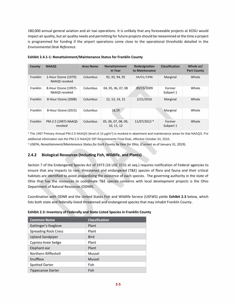
KOSU is located within Franklin County, Ohio, which is included in the Metropolitan Columbus Intrastate Air Quality
Control Region (Columbus AQCR).1 The USEPA has designated Franklin County as marginal non-attainment for ozone
(O3) and maintenance for fine particulate matter (PM2.5) as detailed in Exhibit 2.4.1-1. The FAA Environmental Desk
Reference2 states an air quality analysis for NEPA purposes is not required if a general aviation airport has less than
1 U.S. Environmental Protection Agency (USEPA), 40 CFR § 81.200, Metropolitan Columbus Intrastate Air Quality Control Region, (e-CFR data current as of October 10, 2017). 2 https://www.faa.gov/airports/environmental/environmental_desk_ref/, accessed September 18, 2017.
2-5
180,000 annual general aviation and air taxi operations. It is unlikely that any foreseeable projects at KOSU would
impact air quality, but air quality needs and permitting for future projects should be reexamined at the time a project
is programmed for funding if the airport operations come close to the operational thresholds detailed in the
Environmental Desk Reference.
Exhibit 2.4.1-1: Nonattainment/Maintenance Status for Franklin County
County NAAQS Area Name Nonattainment in Year
Redesignation to Maintenance
Classification Whole or/ Part County
Franklin 1-Hour Ozone (1979)-NAAQS revoked
Columbus 92, 93, 94, 95 04/01/1996 Marginal Whole
Franklin 8-Hour Ozone (1997)-NAAQS revoked
Columbus 04, 05, 06, 07, 08 09/15/2009 Former Subpart 1
Whole
Franklin 8-Hour Ozone (2008) Columbus 12, 13, 14, 15 2/21/2016 Marginal Whole
Franklin 8-Hour Ozone (2015) Columbus 18,19 Marginal Whole
Franklin PM-2.5 (1997)-NAAQS revoked
Columbus 05, 06, 07, 08, 09, 10, 11, 12
11/07/2013 * Former Subpart 1
Whole
* The 1997 Primary Annual PM-2.5 NAAQS (level of 15 µg/m3) is revoked in attainment and maintenance areas for that NAAQS. For
additional information see the PM-2.5 NAAQS SIP Requirements Final Rule, effective October 24, 2016.
1 USEPA, Nonattainment/Maintenance Status for Each County by Year for Ohio, (Current as of January 31, 2019).
2.4.2 Biological Resources (Including Fish, Wildlife, and Plants)
Section 7 of the Endangered Species Act of 1973 (16 USC 1531 et seq.) requires notification of Federal agencies to
ensure that any impacts to rare, threatened and endangered (T&E) species of flora and fauna and their critical
habitats are identified to avoid jeopardizing the existence of each species. The governing authority in the state of
Ohio that has the resources to coordinate T&E species concerns with local development projects is the Ohio
Department of Natural Resources (ODNR).
Coordination with ODNR and the United States Fish and Wildlife Service (USFWS) yields Exhibit 2.3 below, which
lists both state and federally-listed threatened and endangered species that may inhabit Franklin County.
Exhibit 2.3: Inventory of Federally and State Listed Species in Franklin County
Common Name Classification
Gattinger's-foxglove Plant
Spreading Rock Cress Plant
Upland Sandpiper Bird
Cypress-knee Sedge Plant
Elephant-ear Plant
Northern Riffleshell Mussel
Snuffbox Mussel
Spotted Darter Fish
Tippecanoe Darter Fish
2-6
Common Name Classification
Goldeye Fish
Northern Brook Lamprey Fish
Pocketbook Mussel
Shortnose Gar Fish
Black Sandshell Mussel
Washboard Mussel
Indiana Bat Mammal
Threehorn Wartyback Mussel
Smooth Greensnake Reptile
Clubshell Mussel
Paddlefish Fish
Rabbitsfoot Mussel
Fawnsfoot Mussel
Barn Owl Bird
Pondhorn Mussel
Rayed Bean Mussel
Northern Long-Eared Bat Mammal
Scioto Madtom Fish
Running Buffalo Clover Plant
Sources: ODNR State Listed Wildlife Species for Franklin County; USFWS County
Distribution of Federally-Listed Endangered, Threatened, and Proposed Species
According to the OSU Wildlife Hazard Management Plan developed in 2014, several bird and water fowl species have
been observed at the airport including the red-tailed hawk, American kestrel, pigeons, starlings, house sparrows,
Canada geese, mallard ducks, turkey vultures, rough-legged hawks, northern harriers, a bald eagle. Additionally,
white-tailed deer, coyotes, and various rodents have also been observed there.
According to the FAA Aircraft Wildlife Strike Database, the following species have been struck at the airport over the
last 10 years3:
• American kestrel
• Barn swallow
• Big brown bat
• Chimney swift
• Common nighthawk
• Coyote
• Eastern meadowlark
• European starling
• Horned lark
• Killdeer
3Federal Aviation Administration, FAA Wildlife Strike Database, October 9, 2017. Available at: https://wildlife.faa.gov/database.aspx
• Least sandpiper
• Little brown bat
• Mourning dove
• Red bat
• Red-tailed hawk
• Red-winged blackbird
• Short-eared owl
• Turkey vulture
• Upland sandpiper
2-7
In comparing the above list to the list of federally and state listed endangered species in Franklin County (Exhibit
2.3), only the Upland sandpiper appears to have been seen on the airport. Future projects may require a more
detailed study of the on-site and surrounding wildlife to ensure that no endangered or threatened species are
disturbed.
2.4.3 Climate
The Intergovernmental Panel on Climate Change (IPCC) estimates that aviation accounted for 4.1% percent of global
transportation greenhouse gas (GHG) emissions. In the United States, U.S. Environmental Protection Agency (EPA)
data indicate that commercial aviation contributed 6.6% percent of total CO2 emissions in 2013, compared with
other sources, including the remainder of the transportation sector (20.7 percent).4 Increasing concentrations of
GHGs in the atmosphere affect global climate.5 GHG emissions result from anthropogenic sources including the
combustion of fossil fuels. GHGs are defined as including carbon CO2, methane (CH4), nitrous oxide (N2O),
hydrofluorocarbons (HFCs), perfluorocarbons (PFCs), and sulfur hexafluoride (SF6).6 CO2 is the most important
anthropogenic GHG because it is a long-lived gas that remains in the atmosphere for up to 100 years. Research has
shown there is a direct correlation between fuel combustion and GHG emissions. As projects are developed at the
airport, if policy shifts to focus more on climate regulation, the mitigation for CO2 and CH4 production may need to
be considered.
2.4.5 Coastal Resources
No coastal barriers or zones are located near KOSU. The state of Ohio does have a coastal program for Lake Erie,
but it will not be impacted by any potential projects at KOSU.
2.4.6 Department of Transportation Act, Section 4(f)
The Department of Transportation Act, Section 4(f) of 1966 (re-codified and re-numbered as Section 303(c) of 49
U.S.C.) regulates the development of public land used as a public park, recreation area, waterfowl and wildlife refuge,
or historic sites having national, state or local significance. Review of the National Park Service (NPS) and Ohio
Department of Natural Resources (ODNR) databases revealed no parks of concern in the immediate vicinity of
KOSU.7 The historic sites potentially in and around KOSU’s property will be discussed at more length further in this
environmental overview.
2.4.7 Farmlands
The Farmland Protection Policy Act (FPPA), Title 7 of the Code of Federal Regulations (CFR) Part 658, establishes the
US Department of Agriculture (USDA) to develop criteria for identifying the potential impact of federal programs on
4 GHG allocation by economic sector. Environmental Protection Agency (2015). Inventory of U.S. Greenhouse Gas Emissions and Sinks: 1990-2013. Available at: http://www.epa.gov/climatechange/ghgemissions/usinventoryreport.html#fullreport 5 IPCC (2014). Fifth Assessment Report. Available at: https://www.ipcc.ch/report/ar5/syr/ United States Global Change Research Program (2009). Global Climate Change Impacts in the United States. Available at: http://www.globalchange.gov/what-we-do/assessment/previous-assessments/global-climate-change-impacts-inthe-us-2009. 6 Executive Order 13693, Planning for Federal Sustainability in the Next Decade. Available at: https://www.whitehouse.gov/the-press-office/2015/03/19/executive-order-planning-federal-sustainability-nextdecade 7 Ohio State Parks and Watercraft, Find an Ohio State Park. Available at: http://parks.ohiodnr.gov/findapark (September 2017); National Park Service, National Parks in Ohio. https://www.nps.gov/hfc/cfm/carto-states.cfm?state=oh (September 2017), The City of Columbus, Find a Park, Available at: https://www.columbus.gov/recreationandparks/Park-Listing/ (September 2017).
2-8
the conversion of agricultural land to non-agricultural purposes. The FPPA generally protects prime and unique
farmland. Prime farmland is defined in the FPPA as having the “best combination of physical and chemical
characteristics for producing food, feed, fiber, forage, oilseed and other agricultural crops with minimal inputs of
fuel, fertilizer, pesticides, and labor, and without intolerable soil erosion.”
The USDA Natural Resource Conservation Service (NRCS) is the Federal agency responsible for determining if land
converted by a development falls under the purview of the FPPA. Land does not need to be actively farmed for the
FPPA to be under effect. The NRCS will evaluate and rate each area to be converted to non-agricultural use based
upon a number of standards, including these soil characteristics, accessibility to the land, and any surrounding
urbanization. As airport improvements are developed, coordination with the NRCS may be required to determine
the potential for farmland impacts. A review of farmlands was previously conducted for a project that included
extensions on both ends of Runway 9L-27R, 1,800 feet and 1,200 feet respectively. During this review, no prime or
unique farmland soils were identified through this exercise. The Ohio Department of Agriculture (ODA) confirmed
that no prime and unique farmland is located within airport property.8
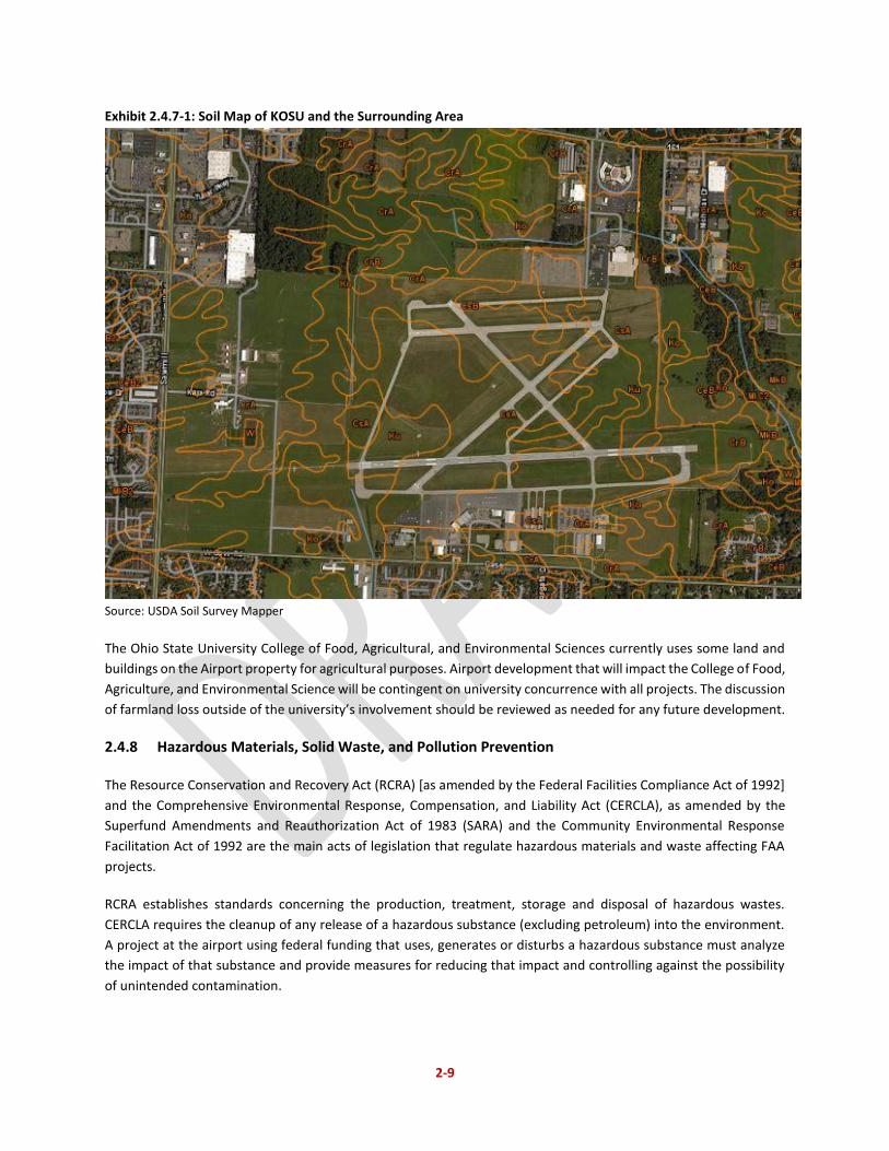
Exhibit 2.4.7-1 shows the soil characteristics in the immediate vicinity of KOSU.9 Soil types on and around the airport
include Ko, CeB, CrA and MkB soils, which are all silty soils types. Ko is a silty clay and CeA, CrA and MkB are silty
loam soil types. Loamy soils are composed of a combination of clay, silt, and sand particles that vary in size from
largest to smallest. This combination of various particle sizes allows for a moist soil that is also well drained, which
is optimal for agricultural purposes.10
8 DLZ Ohio, Inc., Environmental Assessment for Proposed Development at The Ohio State University Airport, Internal Draft Review, December 2004. 9 USDA Natural Resources Conservation Service, Published Soil Surveys for Ohio, Available at: https://www.nrcs.usda.gov/wps/portal/nrcs/surveylist/soils/survey/state/?stateId=OH (September 2017). 10 Michigan State University, Soils, Available at: http://geo.msu.edu/extra/geogmich/soils.html, (September 2017).
2-9
Exhibit 2.4.7-1: Soil Map of KOSU and the Surrounding Area
Source: USDA Soil Survey Mapper
The Ohio State University College of Food, Agricultural, and Environmental Sciences currently uses some land and
buildings on the Airport property for agricultural purposes. Airport development that will impact the College of Food,
Agriculture, and Environmental Science will be contingent on university concurrence with all projects. The discussion
of farmland loss outside of the university’s involvement should be reviewed as needed for any future development.
2.4.8 Hazardous Materials, Solid Waste, and Pollution Prevention
The Resource Conservation and Recovery Act (RCRA) [as amended by the Federal Facilities Compliance Act of 1992]
and the Comprehensive Environmental Response, Compensation, and Liability Act (CERCLA), as amended by the
Superfund Amendments and Reauthorization Act of 1983 (SARA) and the Community Environmental Response
Facilitation Act of 1992 are the main acts of legislation that regulate hazardous materials and waste affecting FAA
projects.
RCRA establishes standards concerning the production, treatment, storage and disposal of hazardous wastes.
CERCLA requires the cleanup of any release of a hazardous substance (excluding petroleum) into the environment.
A project at the airport using federal funding that uses, generates or disturbs a hazardous substance must analyze
the impact of that substance and provide measures for reducing that impact and controlling against the possibility
of unintended contamination.
2-10
Congress established the Superfund Program (administered by the EPA) in 1980 to identify and clean up the nation’s
worst uncontrolled or abandoned hazardous waste sites. Upon review of the National Priority List, no superfund
sites were identified in the vicinity of KOSU.
The Airport currently disposes of its waste at the Franklin County Sanitary Landfill, located south of Downtown
Columbus off Interstate 71 in Jackson Township, Ohio, approximately 13 miles from the Airport. The Landfill is owned
and operated by the Solid Waste Authority of Central Ohio and serves residents and businesses within the Solid
Waste District. The existing waste collection and disposal facilities will be adequate to handle the waste associated
with Airport operations.
According to FAA AC 150/5200-33B, Hazardous Wildlife Attractants On or Near Airports, landfills that have the
potential to attract wildlife should not be located within 5,000 feet of an airport serving piston-powered aircraft,
10,000 feet of an airport serving turbine-powered aircraft, and within five miles of a runway end that could cause
hazardous bird species to fly across the airport’s approach or departure lanes. Per the EPA database of waste removal
facilities, there are no landfills within five miles of KOSU. 11
2.4.9 Historical, Architectural, Archaeological, and Cultural Resources
Section 106 of the National Historic Preservation Act (NHPA) of 1966 protects properties that are listed or eligible
for listing in the National Register of Historic Places (NRHP). The NHPA requires Federal agencies to take into account
the potential effects of their undertakings on historic properties and to coordinate with the State Historic
Preservation Office (SHPO) and any other potentially impacted parties to develop and evaluate alternatives to
modify the undertaking in order to avoid or minimize any potential impacts to these historic resources.
The Columbus Register of Historic Properties, provided by the Historic Preservation Office, indicates that there are
currently no known sites listed in the Ohio Archaeological Inventory on KOSU’s property, and KOSU is not listed in a
historic district.12 Additionally, a Phase I archaeological and architectural field survey was previously conducted for
a project that included extensions on both ends of Runway 9L-27R, 1,800 feet and 1,200 feet respectively, and
included areas that would be directly impacted by construction activities. The archaeological fieldwork was
conducted from April 7-10, 2003, while the history/architecture investigation was conducted on January 31, 2003.
Visual inspection, shovel test pit excavation, and surface collections were conducted as part of the survey. As a
result of the survey, three archaeological sites and no history/architecture properties were found. Investigation into
the archaeological sites revealed that they are not eligible for the NRHP.13
Historic sites can be added to the registry at any time. For this reason, as airport improvement projects are
developed, consultation with the Ohio SHPO office should be made to assess the potential for any impacts on an
individual project basis. More specifically, in accordance with Section 106 of the National Historic Preservation Act,
additional consultation with the Ohio Historic Preservation Office is required prior to the construction of any projects
to identify historic properties and assess the effects of the project undertakings on the properties. Further
11Ohio Environmental Protection Agency, Facility Lists and Other General Documents, Available at: http://www.epa.ohio.gov/dmwm/Home/NonHWFacilityList.aspx#131647705-currently-approved--licensed--registered-facilities-or-organizations (September 2017). 12The City of Columbus, Columbus Zoning Map, Available at: http://gis.columbus.gov/zoning/ (September 2017). 13DLZ Ohio, Inc., Environmental Assessment for Proposed Development at The Ohio State University Airport, Internal Draft Review, December 2004.
2-11
consultation must include consideration of the Area of Potential Effects of the Airport expansion and the level of
effort that will be required to comply with requirements to identify historic properties.
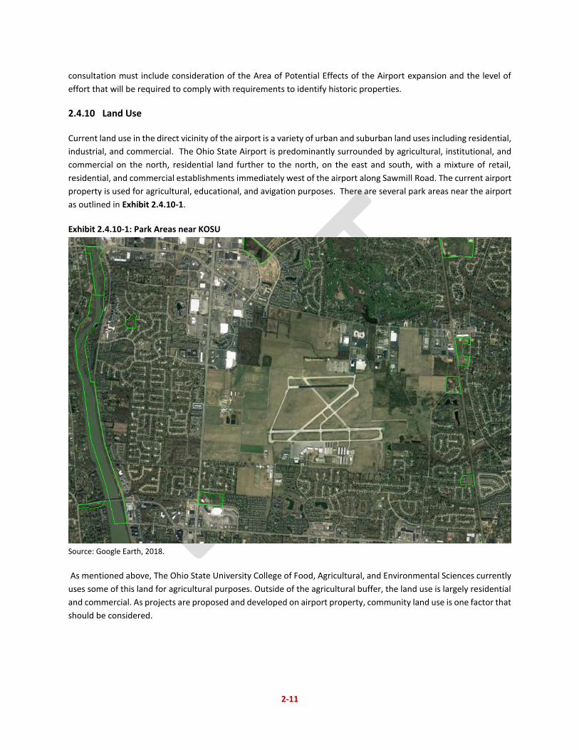
2.4.10 Land Use
Current land use in the direct vicinity of the airport is a variety of urban and suburban land uses including residential,
industrial, and commercial. The Ohio State Airport is predominantly surrounded by agricultural, institutional, and
commercial on the north, residential land further to the north, on the east and south, with a mixture of retail,
residential, and commercial establishments immediately west of the airport along Sawmill Road. The current airport
property is used for agricultural, educational, and avigation purposes. There are several park areas near the airport
as outlined in Exhibit 2.4.10-1.
Exhibit 2.4.10-1: Park Areas near KOSU
Source: Google Earth, 2018.
As mentioned above, The Ohio State University College of Food, Agricultural, and Environmental Sciences currently
uses some of this land for agricultural purposes. Outside of the agricultural buffer, the land use is largely residential
and commercial. As projects are proposed and developed on airport property, community land use is one factor that
should be considered.
2-12
2.4.11 Natural Resources and Energy Supply
Executive Order 13123, Greening the Government through Efficient Energy Management, requires federal agencies
to reduce their consumption of energy and water and to also reduce the air emissions associated with petroleum
use. Federal agencies are encouraged to reduce this petroleum use through the expansion of renewable energy and
sustainability practices. Most airport improvements at an airport like KOSU do not result in energy demand changes,
increases in water consumption levels, or the utilization of any other unusual materials or resources in limited supply.
2.4.12 Noise and Compatible Land Use
Noise: Noise contours were developed for the preferred development alternative at detailed in Chapter 5 of this
master plan. The analysis was done to evaluate the impact of aircraft noise on sensitive land uses in the Airport area.
The full analysis is included in Appendix H. Sensitive land uses include: residential areas, schools, parks, hospitals,
churches, amphitheaters, and libraries. FAA Advisory Circular 150/5020-1, Noise Control and Compatibility Planning
for Airports, has identified land use compatibility guidelines that relate types of land uses to airport noise levels.
Based on these guidelines, there are no incompatible land uses within the yearly 65 DNL day-night sound levels.
There currently exist few remaining undeveloped sites in Northwest Columbus. As the city considers residential
development for sites in the immediate vicinity of the Airport, the university requests that a disclosure statement
be incorporated into the plat(s) and deeds, as was previously used by the City for other developments around the
Airport, and which can be referenced through City Ordinance 484-92, Section 7, as follows:
That this ordinance is further conditioned upon the following notice appearing on the plat(s) of the site and in the
deed as part of every individual lot conveyance:
Disclosure – This subdivision is located approximately ____’ from the end of the principal runway at Don
Scott Field, the Ohio State Airport, and is located adjacent the approach and departure paths for aircraft
using the runway. Depending upon weather conditions, there may be times that aircraft will be operating
at minimum of approximately ____’ above mean sea level (___’ above ground level) as they pass by the
subdivision. The subdivision will be subject to noise exposure from aircraft. Due to the nature of this traffic,
residents of this subdivision shall be prohibited from using or allowing to be used any equipment which can
interfere with the communications and other electronics of the Airport, or which will produce Electro
Magnetic Radiation (EMR) from their dwelling or lot thereon, which EMR would unreasonably or
dangerously interfere with the communications, navigational facilities, or other electronics of the Airport.
Compatible Land Use: Any airport project using Federal funding must be compatible with the plans of public agencies
for the overall development of the area. The Ohio Department of Transportation has a State Airport System Plan in
place for the airports included in the National Plan of Integrated Airport Systems (NPIAS), which includes KOSU.
Additionally, Ohio State has commissioned a master plan, of which this document is a part of, to be developed in
order to analyze and direct potential future progress in the context of its location.
Other factors that may create land compatibility issues are when a proposed development would negatively impact
activities at the airport. One such example is municipal solid waste landfill facilities (MSWLF), which are a known
attractant of large wildlife that may interfere with airport traffic and other airport business. As developments are
pursued on the airport and in the broader community, compatible land use should always be a major consideration
for those designs.
2-13
2.4.13 Socioeconomic, Environmental Justice, and Children’s Environmental Health and Safety Risks
Socioeconomics is an umbrella term used to describe aspects of a project that are either social or economic in nature.
A socioeconomic analysis evaluates how elements of the human environment such as population, employment,
housing, and public services might be affected by the proposed action and alternative(s). Environmental justice is
the fair treatment and meaningful involvement of all people regardless of race, color, national origin, or income with
respect to the development, implementation, and enforcement of environmental laws, regulations, and policies.
Protection of children from environmental health risks and safety risks is identifying and assess environmental health
risks and safety risks one has reason to believe could disproportionately affect children.
The Uniform Relocation Assistance and Real Property Acquisition Policies Act of 1970 requires that any time federally
funded projects have the potential to cause extensive relocation or fragmentation of neighborhoods and
communities, disproportionately high impacts on minority or low income communities, disproportionate health and
safety risk to children, or significant community disruption, the degree of the impact and any need for mitigation or
possible alternative measures must be identified. Executive Order 12898, Federal Actions to Address Environmental
Justice in Minority Populations and Low-Income Populations, its accompanying presidential memorandum, and order
DOT 5610.2, Environmental Justice, require the FAA to provide opportunity for meaningful public involvement by
minority and low-income populations during any proposed development that might disproportionately impact them.
Executive Order 13045, Protection of Children from Environmental Health Risks and Safety Risks, requires the FAA to
consider environmental health and safety risks that may disproportionately affect children.
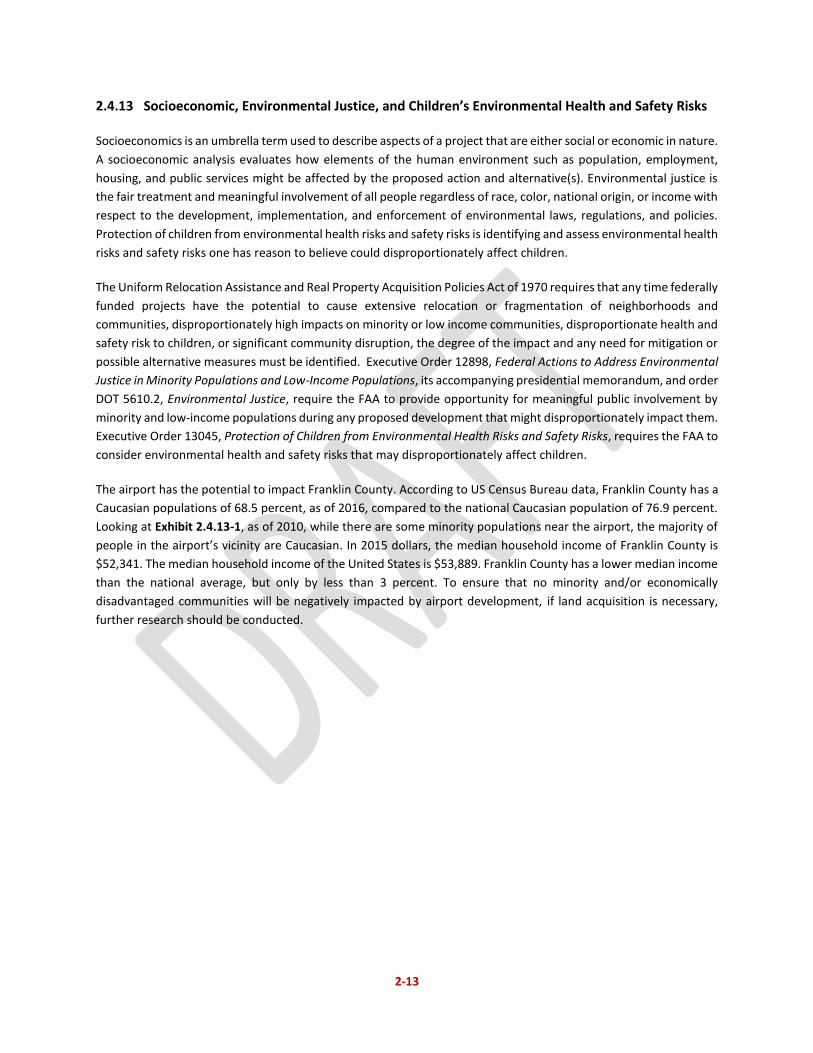
The airport has the potential to impact Franklin County. According to US Census Bureau data, Franklin County has a
Caucasian populations of 68.5 percent, as of 2016, compared to the national Caucasian population of 76.9 percent.
Looking at Exhibit 2.4.13-1, as of 2010, while there are some minority populations near the airport, the majority of
people in the airport’s vicinity are Caucasian. In 2015 dollars, the median household income of Franklin County is
$52,341. The median household income of the United States is $53,889. Franklin County has a lower median income
than the national average, but only by less than 3 percent. To ensure that no minority and/or economically
disadvantaged communities will be negatively impacted by airport development, if land acquisition is necessary,
further research should be conducted.
2-14
Exhibit 2.4.13-1: Visual Representation of Columbus’ Racial Distribution
Source: University of Virginia Weldon Cooper Center for Public Service, https://demographics.virginia.edu/DotMap/ (September
2017).
2.4.14 Visual Effects (Including Light Emissions)
Airports cause light emissions that can impact visually sensitive land uses in an airport area. The characteristics of
many runway lighting systems create potential sources of annoyance to nearby such as homes, parks, or recreational
areas in the airport vicinity if light is directed towards light-sensitive land uses. On the other hand, visual effects deal
broadly with the extent to which airport development contrasts with the existing environment, architecture, historic
or cultural setting, or land use planning.
Several neighborhoods border KOSU, including The Gables, Misty Meadows, Sycamore Hills, Olentangy Park,
Brookside Woods, and Sawmill Park to name a few.14 Because of the close proximity of these neighborhoods, visual
effects should be considered with airport development projects. Certain impacts can be mitigated. For example,
lighting on runways and taxiways can be shielded or controlled by pilots to minimize emissions that would impact or
cause annoyance to the surrounding areas.
2.4.15 Water Resources (Including Wetlands, Floodplains, Surface Waters, Groundwater, and Wild and
Scenic Rivers)
Wetlands: There are four primary regulations governing federal projects that impact wetlands: Executive Order
11990, DOT Order 5660.1A, the Rivers and Harbors Act of 1899, and Section 404 of the Clean Water Act. This
authority generally is invested in the US Army Corps of Engineers (USACE), but is often partially delegated at the
local level depending on the agreements the state has with USACE. According to review of the US Fish and Wildlife
14 Neighborhoods of Columbus, Available at: https://www.google.com/maps/d/viewer?mid=1ZyLio1JNf9oil4nNLbVudqEyWeA&hl=en_US&ll=39.99601050132985%2C-82.91647914999999&z=11 (September 2017.)
2-15
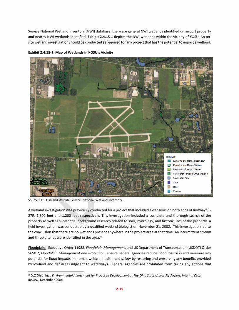
Service National Wetland Inventory (NWI) database, there are general NWI wetlands identified on airport property
and nearby NWI wetlands identified. Exhibit 2.4.15-1 depicts the NWI wetlands within the vicinity of KOSU. An on-
site wetland investigation should be conducted as required for any project that has the potential to impact a wetland.
Exhibit 2.4.15-1: Map of Wetlands in KOSU’s Vicinity
Source: U.S. Fish and Wildlife Service, National Wetland Inventory.
A wetland investigation was previously conducted for a project that included extensions on both ends of Runway 9L-
27R, 1,800 feet and 1,200 feet respectively. This investigation included a complete and thorough search of the
property as well as substantial background research related to soils, hydrology, and historic uses of the property. A
field investigation was conducted by a qualified wetland biologist on November 21, 2002. This investigation led to
the conclusion that there are no wetlands present anywhere in the project area at that time. An intermittent stream
and three ditches were identified in the area.15
Floodplains: Executive Order 11988, Floodplain Management, and US Department of Transportation (USDOT) Order
5650.2, Floodplain Management and Protection, ensure Federal agencies reduce flood loss risks and minimize any
potential for flood impacts on human welfare, health, and safety by restoring and preserving any benefits provided
by lowland and flat areas adjacent to waterways. Federal agencies are prohibited from taking any actions that
15DLZ Ohio, Inc., Environmental Assessment for Proposed Development at The Ohio State University Airport, Internal Draft Review, December 2004.
2-16
impact a floodplain unless no feasible alternative exists. Encroachment is defined as any action that would cause
the 100-year water surface profile to rise by one foot or greater.
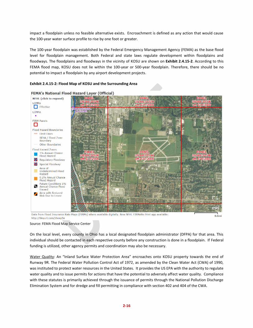
The 100-year floodplain was established by the Federal Emergency Management Agency (FEMA) as the base flood
level for floodplain management. Both Federal and state laws regulate development within floodplains and
floodways. The floodplains and floodways in the vicinity of KOSU are shown on Exhibit 2.4.15-2. According to this
FEMA flood map, KOSU does not lie within the 100-year or 500-year floodplain. Therefore, there should be no
potential to impact a floodplain by any airport development projects.
Exhibit 2.4.15-2: Flood Map of KOSU and the Surrounding Area
Source: FEMA Flood Map Service Center
On the local level, every county in Ohio has a local designated floodplain administrator (DFPA) for that area. This
individual should be contacted in each respective county before any construction is done in a floodplain. If Federal
funding is utilized, other agency permits and coordination may also be necessary.
Water Quality: An “Inland Surface Water Protection Area” encroaches onto KOSU property towards the end of
Runway 9R. The Federal Water Pollution Control Act of 1972, as amended by the Clean Water Act (CWA) of 1990,
was instituted to protect water resources in the United States. It provides the US EPA with the authority to regulate
water quality and to issue permits for actions that have the potential to adversely affect water quality. Compliance
with these statutes is primarily achieved through the issuance of permits through the National Pollution Discharge
Elimination System and for dredge and fill permitting in compliance with section 402 and 404 of the CWA.
2-17
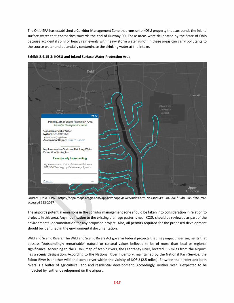
The Ohio EPA has established a Corridor Management Zone that runs onto KOSU property that surrounds the inland
surface water that encroaches towards the end of Runway 9R. These areas were delineated by the State of Ohio
because accidental spills or heavy rain events with heavy storm water runoff in these areas can carry pollutants to
the source water and potentially contaminate the drinking water at the intake.
Exhibit 2.4.15-3: KOSU and Inland Surface Water Protection Area
Source: Ohio EPA, https://oepa.maps.arcgis.com/apps/webappviewer/index.html?id=38d04980a40d41f59d832a50f3fc0b92,
accessed 112-2017
The airport’s potential emissions in the corridor management zone should be taken into consideration in relation to
projects in this area. Any modification to the existing drainage patterns near KOSU should be reviewed as part of the
environmental documentation for any proposed project. Also, all permits required for the proposed development
should be identified in the environmental documentation.
Wild and Scenic Rivers: The Wild and Scenic Rivers Act governs federal projects that may impact river segments that
possess “outstandingly remarkable” natural or cultural values believed to be of more than local or regional
significance. According to the ODNR map of scenic rivers, the Olentangy River, located 1.5 miles from the airport,
has a scenic designation. According to the National River Inventory, maintained by the National Park Service, the
Scioto River is another wild and scenic river within the vicinity of KOSU (2.5 miles). Between the airport and both
rivers is a buffer of agricultural land and residential development. Accordingly, neither river is expected to be
impacted by further development on the airport.
2-18
2.4.16 Summary of Likely Development Concerns
All projects on the airport must undergo environmental analysis as required by NEPA at the time a project is
proposed for implementation. A potential area of concern for the airport in relation to development is water
resources. The airport has several NWI wetlands within the vicinity of its property and will need to conduct a wetland
investigation and coordinate with federal and state agencies for any necessary permitting before construction for
any new projects on areas that could have wetlands. Also, the airport’s potential emissions to the inland water
corridor management zone should also be taken into consideration in relation to projects in this area. Also any
modification to the existing drainage patterns should be reviewed as part of the environmental documentation for
any proposed project.