2 description of proposal - university of washingtoncpd.uw.edu/cpo/sites/default/files/file/uw ima...
TRANSCRIPT

Draft Supplemental Environmental Impact Statement
IMA Field No. 1 Improvements| January 2012 2-1 University of Washington
2 DESCRIPTION OF PROPOSAL
2.1 Proponent
The proposal is sponsored by the University of Washington.
2.2 Location of Proposal
IMA Field No. 1 is situated in northeast Seattle, on the south side of NE 45th Street in the northeastern portion of the University of Washington campus, as shown on Figure 2-1.
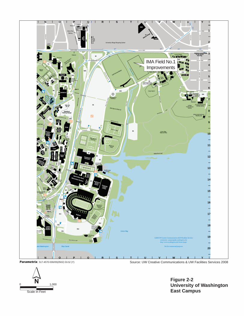
The east area of the campus, shown on Figure 2-2, is devoted primarily to athletic and recreational facilities, surface parking, and open space. The nearest facilities and buildings to IMA Field No. 1 are the University of Washington Environmental Safety Office building, storage buildings, and the corporation yard located immediately south of the site, as well as the University of Washington Ceramics and Metal Arts (CMA) building located at the intersection of Mary Gates Drive and NE Clark Road. To the east of the site is the University of Washington Laurel Village Student Housing site east of Mary Gates Drive.
Other athletic facilities are located east and southeast of the field including the University of Washington Golf Driving Range about 500 feet to the east. The Intramural Activities Building is about a half mile to the southwest as are other athletic facilities and buildings, including the Hec Edmundson Pavilion, Nordstrom Tennis Center, and the Dempsey Indoor Center.
Parking Lot E4 with about 150 parking spaces is located across NE Clark Road from the site. Parking Lot E1 with about 3,500 spaces is located about 900 feet east of the field.
The Union Bay Natural Area is a 74-acre site located generally south of the Environmental Safety building, and the corporation yards. The most important habitat areas include the Lake Washington shoreline and wetland complexes. It is used by a variety of wildlife and for passive recreation by birdwatchers and students of restorative natural landscapes.
A site plan of the proposed field improvements is shown in Figure 2-3.
The major features of the project include the following:
Grading of the site;
Addition of base material;
Installation of curbing, fencing, and lights;
Installation of the artificial turf surface; and
Restoration of natural grass turf on portions of the field without artificial turf.

Dru
mhe
ller
Foun
tain
Port
age
Bay
Lake
Was
S12
S1
W14
W13
C8
C10
W4V
W24
W29
W40
W39
W42
W34
W10
W12
W14
W13
W9
W2
W41
W3
X-Lo
tW
7
W6
H17
-18
C10
N5
N3
W35
H17
-18
W8
C10
C10
C1–
C5
Leve
lsC
entr
al P
laza
Park
ing
Gar
age
W11
C6
N28 top
Sout
h Ca
mpu
s
Park
ing
Garag
e
S7
S5
S6
W40
S9
S8
S8
C7
C7
N1
S17
W38
C7
C17
W47
W48
W50
PP
P
PP
P
P
P
P
PP
P P
4041
Gat
e 5
Gat
e 2
Gat
e 1
tG
a
6e
Gat
e 7
Den
nFi
eld Te
Arc
hery
Ran
ge
Parr
ingt
onLa
wn
Denny Yard
$
$
$
Flag
pole
edal
G ehTr
Sut
plue
c
aS
mukaio
pwei
tnV
Sno
mladnoP gni
moH
War
Mem
oria
l
Paul
G. A
Ctr.
for C
omSc
i. & En
g
Ande
rson
Kirsten
Winken-
werder
OceanScie
nces
Bota
nyGre
en-
hous
e
Hitchcock
Mac
kenz
ie
Child
Care
Cntr.
Ethn
icCu
ltrl.
Cntr.
Mer
cer
3716
Anne
x 4
Aca
dem
icCo
mpu
ting
Cent
er
Marine Studies
Purc
h.A
cctg
.
Atm
osph
eric
Sci
.
Geo
phys
ics
HU
B Ya
r d
Phys
ics
/ A
stro
nom
y
ARsch
HenryArt
Gallery
4311
Arc
hite
ct.
43 2
1 Tower
Gut
hrie
Denny
Parri
ngto
n
Art
Smith
Thom
Balm
er
Kane
Suzz
allo
Lib
rary
Bagl
ey
Mag
nuso
n He
alth
Scie
nces
Cent
er
Kinc
aid
Auditoriu
m
Gou
ld
Mea
ny
Schm
itz
Han
see
Wes
tC
amp
usPa
rkin
gG
arag
e
Park
.Sr
v.
Ode
gaar
dU
nder
grad
Lib
rary
Chem
Library
Hutch
inso
n
Johnson
Mar
y
Gat
es
Fish
ery
Scie
nces
J
KML
A
B CD
Svcs
.
Hen
ders
on
Cond
on
Publ
icat
ions
Serv
ices
Fish
erie
sTe
achi
ngRs
ch.C
tr.Br
yant
s
Bloe
del
Raitt
M
Mille
r
Gowen
Alle
n
Libr
ary
Burk
eM
emor
ial
Was
h. S
t.M
useu
m
Sieg
3941
4545
Harris L
ab.
Ocea
nog.
Clinic
Sout
h
Expe
rimen
tal
Educ
atio
nUn
it
Fishe
ries C
ente
r
Sout
hCa
mpu
sCe
nter
Ocean Tc
h.
Mar
ine
Scien
ces
Ger
berd
ing
Chemistry
Bens
on
Terr
y
Univ
ersit
y of W
ashi
ngto
n
Med
ical C
ente
r
SC
Elec
trica
l Eng
inee
ring
4100
3939
3935
3947
1429
fo knaBacir e
mA
it ucexev
Ecu
dn
Eoi t a
nC
er
te
vyS
nal
eT
ea
ha
t
dnr
uoC
nm
ls
909
4512
4516
4518
4522
4534
-1/2
4507
yti sr evi nUer otskooB
Quad
Will
iam
H. G
ates
1100
Mer
cer
4225
UW
MC
Roos
evel
t
4245
4225
William H. Fo
ege Bioen
gineerin
g
Genome
Scien
ces
Mar
kM
cDer
mot
tPl
aza
Land
er
Save
ry
1107
U of WInfo. & Visitors Center
JohnsonxennA
T S
CO
A
) A egaraG(
Col
leg
iana
W49
(Garage B)W45
W46
Hug
hes
P
enth
ouse
Thea
tre
Brya
nts
Ann
ex
Met
roPu
mpi
ngSt
atio
n
Med
icin
alH
erb
Gar
den
Com
m.D
uch.
Apt.
Soci
al W
ork
/Sp
each
an
d
Hea
rin
g S
cien
ces
Build
ing
Broo
klyn
Build
ing
Floy
d an
dD
elor
es J
ones
Play
hous
e
1303
Cour
t
3945
3937
GutherieAnnexes1- 4
Art
sTi
cket
Gug
genh
eim
Anne
x
Inst
ruct
iona
lCe
nter
/The
ater
rodoehT
nesbocaJ
esb
O t
av
yr
ro
.c
Ogonae
rR
aeshc
emahgni nnuC
kniwne
We enn
Ax
olpm
.yE
Qua
tern
ary
Rsch
.Ctr.
3902
ekalhtroN
dlB.g
Cent
er o
n Hu
man
Deve
lopm
ent a
nd
Disa
bilit
y
pma
lC
ine
a
ulA
inm o
eu
Hs
htuoSup
mas
C ot
Cs
icur
n not
nP
at
l L b
a
668
co
Ona
he
pary
g okc
D
oO
naer
cy
pag
hr
tSe
gao
lgan
Eose
U.S
.Pos
t
Wes
tRe
ceiv
ing
Stat
ion
Com
mun
ityD
esig
n Ce
nter
3900
Entr
ance
toG
ate
4
Land
er-T
erry
Hal
ls
Alle
n Ce
nter
for t
heVi
sual
Art
s
UW
Tow
er
tg
Sno
dlohr
Guggenheim
Stev
ens
E5 P$e
Fenc
e
Cons
truc
tion
Are
a
Road
Gat
e
Bank
Mac
hine
Bran
ch L
ibra
ry
Emer
genc
y Ph
one
Pay
Phon
e
Bus
Stop
Bus
Rout
e
Aut
omat
ic P
arki
ng G
ate
Gat
ehou
se(w
ith e
mer
genc
y ph
one)
Cam
pus
Entr
ance
sBu
ildin
g
Brid
ge/O
verp
ass
Cam
pus
Park
ing
Are
a
Publ
icPa
rkin
g A
rea
Park
ing
(und
ergr
ound
)
Build
ing
(und
ergr
ound
)
Path
/Sid
ewal
k/W
alkw
ay
KEY
TOM
AP
SYM
BOLS
Rem
ovab
leBo
llard
sO
ne W
ay R
oad
(arr
ow
nimaj ne
ll aH .
DB
t na
Inil
pi csidr
ye
rR
hcr aese
20
19
18
17
16
15
14
13
12
11
10987654321
ML
KJ
IH
GF
ED
CB
ML
KJ
IH
GF
ED
CB
E. EVA DRAVRAH
MASONRO
A
NE
NO
RTH
LAKE
PLA
CE
ISLANDLANE
Grieg G
arde
n
NE
CA
MPU
SPA
RKW
AY
OKANOGAN LANE
BROOKLYN AVE NE
Rainier Vista
UNIVERSITY WAY NE
NE
40TH
STR
EET
PLAC
EGOE
R GE
WS
AH
ING
TON
LANE
SKAM
ANIA
LANE
15TH
AVENE
ERTS D
N24 EN
ET
SKAG
IT LA
NE
C
MALLALCENAL
KLICK
ITAT L
ANE THU
RSTO
N L
ANE
NE
NO
RTH
LYA
W EKA
UNIVERSITY BRIDGE
NE P
ACIF
IC S
TREE
T
BURK
E-GI
LMAN
TRAI
L
NE P
ACIFI
C ST
REET
COLU
MBI
A R
OAD
COLU
MBI
A R
OAD
EN EVA NYLKOORB
ENEVA HT11
ENYAW TLEVESOOR
HT05 &
HT54 EN
EERTT
SI
XES
TEERTS
DN24
EN
T
W YAW SNEVETS
EERTS DR34 E
NT
ENEVA HT21
LIN
OCNL
AW
Y
04 EN
HTTS
TEER
NE
NO
RTH
LAKE
WAY
EGDI RBLANACPI HS
EERTS HT44 E
NT
INTERSTATE 5 FREEWAY
TEERTS HT74 E
N
ENEVA HT71
ENEVA HT02
ENEVA HT91
EN EVA HT61
YAW LAI ROMEM
CHEL
AN L
ANE
PIERC
E
LANE
KING
LANE
EN EVA HT51
SAN JU
AN RO
AD
GARFIELD LANE
BENTON LANE
GRA
NT
LAN
E
TS TS14 EN
ERTS D
N24 EN
ET
ERTS DR34 E
NTE
EN EUNEVA HT4
EN EUNEVA HT5
EN EVA HT9
EN EVA HT8
ERTS DR34 E
NET
EERTS HT54 E
NT
EN EUNEVA HT5
FAIRVIEW AVE. E
YAWEERF5ETATSRETNI
EASTLAKEAVE. E
E AL
LISO
N S
T.
EN EVA HT7
SPOKA
NE LAN
E
NE
P AC I
FIC
STRE
ET
ENEVA HT81
ENEVA HT51
KT
ES
IN
AL PA
KITTITAS L
ANE
EN YAW YTI SREVI NU
EH
AMLI
N S
T.
FRANKLIN AVE. E
NE
40TH
STR
EET
EN EVA HT6
NE
BOAT
STR
EET
ROAD
COW
LITZ
ASOTIN
CLA
LLA
MLA
NE
SPO
KANE
LAN
E
WH
ITM
AN
LA
NE
KLICKITAT LANE
KING
LANE
SAN JU
AN ROAD
FERRY
PLACE
ETSV
SNE
NAL
E
CLA
LLA
MPL
ACE
GRA
NT
PLA
CE
GARFIELD PLACE
THURST
ON
LANE
THURST
ON PLA
CE
CHEL
AN PL
ACE
RAINIERVISTA
COW
LITZ
PLA
CE
ADAMSPLACE
ADAMS ROAD
TIKP
AE
SN
AL
WAY
WT
E
SS
NEV
STEV
ENS W
AY E
JS
NH
ON
OI
CRC
LE
Lake
Was
hing
ton
Ship
Can
al
Drainage Canal
Uni
on B
ay
Drainage Canal
H
E5
C14
C15 E11
E11
E12
E10
E10
E11
E9
E10
N26
N24
C12
C12
E17
Tria
ngle
Park
ing
Gar
age
C20
, 21C1
2
C10
N24
Pad
elfo
rdPa
rkin
g G
arag
e
N22
C19
N6
N9,
10,1
1
N13
,14
, 15
N7
N6
N8
N8
N3
E12
E16
To S
and
poi
ntH
ousi
ng
To
Bla
kely
Vill
age
N26
N16
, 18,
20, 2
1
N25
E2
E8
E8
E1
C12
N12
E16
C15
C15
E14
E4
E3H
12
H12
N24
C 17
E6
E15
N12
N8
C17
Gat
e 3
Gat
e 4
Gat
e 8
Gat
e 7
Den
nyFi
eld
IMA
Sp
orts
Fie
ld #
2
Tenn
is C
ourt
sIMA
Spo
rts
Fiel
d #3
Socc
er F
ield
Tenn
is Co
urts
Sun
Dec
k
gnib
milC
kcoR
Golf
Driv
ing
Rang
e
proC1
Y dra
oY
prC
dr2
a
Base
bal
l F
ield
Uni
on B
ay
Nat
ural
Are
a
tet a
Wnorfr
t rli a
$
em
cr
Ene
yg sile
pH
ot
latipsoH mE
yre
cnege
Ecnartn
Te
dalG eh
rS
utplu
ec
udai
tV
c
mi ehdr oN oTtr uoC
Paul
G. A
llen
Ctr.
for C
omp.
Sci. &
Eng.
UW
MC
Surg
ery
Pavi
lion
Kirsten
Robe
rts
Wilc
ox
Winken-
werder
Pade
lford
McM
ahon
nzie
McC
arty
Commun
icatio
ns
HU
B Ya
rd
Edm
unds
on P
avili
on
Stud
ent
Uni
onBu
ildin
g(H
UB)
Engr
.
Libr
.
The
Uni
v.of
Was
h.C
lub
Fluk
e
Hal
lH
ealt
h
Plant Ops.
Aerosp.
Rsch.
Loew
Mech. Engr.
Eng Annex
Pow
erPl
ant
Art
th
Thom
son
Clark
Han
see
Hag
gettNo
rth
Phys
ics
Labo
rato
ry
Graves Annex
Nor
dstr
omTe
nnis
Cent
erD
emps
eyIn
door
Cent
er
Stad
ium
CEN
PAIn
stru
men
tSh
op
Lewis
Hutch
inson
Graves
Intr
amur
alA
ctiv
ities
Mus
ic
Mille
r
Alle
n
Libr
ary
Mor
e
Sieg
Mer
rill
hing
ton
r
PlantServices
4625
Elec
trica
lEng
inee
ring
vyS
nal
ntaehT
a rd
e lCo
su
nm
4535
Quad
Pavilion Pool
Spor
ts M
ed. C
linic
MN
P
Q
RS
CCD
C2
T U V
X
Y
W
Wom
en's
Soft
bal
lFi
eld
Uni
vers
ity V
illag
e Sh
oppi
ngCe
nter
Met
roPu
mpi
ngSt
atio
n
Nor
thW
est
Hor
ticul
tura
lSo
ciet
y H
all
Issa
cson
Mill
er L
ibra
ry
Tran
s. Sv
cs.
and
Mot
orPo
ol
Aer
odyn
.La
b
Envi
ronm
enta
lSa
fety
Stor
age
Bldg
.
Lew
isA
nnex
es
Muelle
r
Uni
v. F
acili
ties
43
62
Gug
genh
eim
Anne
x
Phys
. Pla
nt
Mor
eAn
nex
Wnosli
Anenx
nid
wnekW
r ere
xnn
Ae
Reb
stro Ann
ex
Plan
t Op.
Anne
xes 2
-6
12
VTa
it
Slle
et .mreT
OutdoorPrac
tice
Facilit
y
tW
re
af
to
rn s
cA
eitivit et
Cre
n eonaC
esuoH
Dou
glas
Res
earc
hC
onse
rvat
ory
4012esuo
H
Shel
lhou
seA
nnex
nosliW
i
mareC c
Lab
Cer
amic
Met
al A
rts
Laur
el V
illag
e
Con
ibea
rSh
ellh
ouse
Plan
t Op.
Anne
x 7
5
Envi
ronm
enta
l
Urb
anH
orti
cult
rue
Cen
ter
12
Mot
orPo
ol
Park
ing
Entr
ance
toG
ate
4
TSA
nnex
1
PSAnnex 1
Guggenheim
©200
8UW
Cre
ative
Com
mun
icatio
ns &
UW
Facil
ities
Serv
ices
com
men
ts:ca
mpm
ap@u
.was
hing
ton.e
duht
tp://
www.
wash
ingt
on.ed
u/ho
me/
map
s/
Notf
orco
mm
ercia
l pur
pose
s
Yx
WV
UT
SR
QP
ON
M
20
19
18
17
16
15
14
13
12
11
10987654321
YX
WV
UT
SR
QP
ON
M
MASONRO
AD
WA
HKIA
KUM
LANE
22NDAVENE
JEFFERSON ROAD
BURK
E-GILM
ANTRAIL
Grieg G
arde
n
ierVista
WALLA WALLAROAD
MASON ROAD
SKAG
IT LA
NEW
AH
KIA
KUM
LAN
E
MONTLAKE BOULEVARD NE
BURKE-GILMAN TRAIL
WHITMAN COURT
CHEL
AN WALK
WAY
bU
nr
oa
He
rutl ucitr
dF
l eu
hi
eso
ERTS TS14 ETE
N
ERTS HT24 E
NTE
ENEVA HT63
EN EVA HT53
EN EVA TS12
WALLA WALLA ROAD
WA
HKI
AKU
M L
AN
E
EN EVA HT02
ANE
ANEYAKIMA LANE
ROAD
WALLA WALLA ROAD
WALLA WALLA ROAD
EERTS HT54 E
NT
NE 4
5TH
PLAC
E
HT54 EE
N
RTTE
S
EERTS HT44
EN
T
ERTS HT34 E
NTE
LANE
EN EVA HT52
CLAR
K RO
AD
MARY GATES MEMORIAL DRIVE
WH
ATCO
M
LP HT44 E
EA
NC
ROA
D
NE
PACI
FIC
PLA
CE
TEERTS HT74 E
N
TEERTS HT74 E
N
ENEVA HT63
EYAW SNEVETSMONTLAKE BRIDGE
LAN
E N
FRANKLINECALP
SNO
HO
MIS
H L
AN
ES
WA
LLA
WA
LLA
LA
NE
WA
LLA
WA
LLA
LA
NE
WH
ITM
AN
LA
NE
SNO
HO
MIS
H
LAN
PLAC
E
MASONPLACEBURKE-GILMAN TRAIL EERTS HT54 E
NT
CLARK
PLACE
UNION
ROAD
BAY
ECIVRES
WU
DA
OR
PEND OREILLE
PLACE
RAINIER VISTA
FRANKLIN LANE
ECALP YAB UNION
WAYE
STEVEN
S
STEV
ENS W
AY E
LAN
E
SOUTH
OREILLE
PEND
DOUGLAS ROAD
CANAL ROAD
WA
HKI
AKU
M
SNO
HO
MIS
H
Fig
ure
2-1
Un
iver
sity
of
Was
hin
gto
nC
amp
us
Sca
le in
Fee
t
1,00
00
Sou
rce:
UW
Cre
ativ
e C
omm
unic
atio
ns &
UW
Fac
ilitie
s S
ervi
ces
2008
517-
4570
-006
/05(
0502
) 01
/12
(Y)
aiP
ara
me
trix
IMA
Fie
ld N
o.1
Impr
ovem
ents
Drumheller
Fountain
Lake Was
S1
C10
C10
N5
N3
C10
C10
C1–C5 LevelsCentral Plaza
Parking Garage
C6
South Campus
ing Garage
S9
S8
S8
C7
C7
C7
C17
Gate 2
Gate 7
DennField
Te
Archery
Range
ParringtonLawn
Denny
Yard
$
Flagpole
edalG ehTS rutpluc e
SalmonHoming Pond
WarMemorial
Paul G. A Ctr. for ComSci. & Eng
Anderson
Kirsten
Winken-
werder
BotanyGreen-
house
Mackenzie
Atmospheric Sci.
Geophysics
HUB Yard
ARsch
Denny
Parrington
Art
Smith Thom
Balmer
Kane
SuzzalloLibrary
Bagley
Magnuson Health Sciences
Center
d
Hansee
OdegaardUndergrad
Library
Chem
Library
Hutchinson
Johnson
Mary
Gates
Bloedel
Raitt
M
Miller
Gowen
Allen
Library
MemorialWash. St.Museum
Sieg
Clinic
South
Experimental
EducationUnit
Fisheries Center
Gerberding
Chem
istryBenson
University of Washington
Medical Center
Electrical Engineering
fo knaBAmerica
itucexE vecudE noita
C ne t re
Sy vl anT eh a et a r nd
Co ul mns
Quad
Savery
John
son xenn
A
Hughes Penthouse
Theatre
MetroPumping
Station
MedicinalHerb
Garden
Guggenheim
Annex
rodoehTnesbocaJ
esbO tavr yro
mahgninnuC
kniW enweAnnex
Quaternary
Rsch. Ctr.
Center on Human
Development and
Disability
pmaC lina e
P nal tL ba
Entrance toGate 4
Guggenheim
MLK
MLK
MASON ROA
ISLA
ND
LAN
E
Grieg Garden
OKANO
GAN LANE
Rainier Vista
INGTON LANE
SKAGIT LANE
C
MALLALCE
NAL
KLICKITAT LANE
THURSTON LANE
BURKE-GILMAN TRAIL
NE PACIFIC STREET
COLUMBIA ROAD
COLUMBIA ROAD
EN EVA
HT71
EN EVA
HT02
EN EVA
HT91
YAW LAIR
OME
M
CHELAN LANE
PIERCE L
ANEKING LANE
GA
RFIE
LD L
AN
E
BENTON LANE
GRANT LANE
SPOKANE LANE
EN EVA
HT81
WHITMAN LANE
KLIC
KITA
T LA
NE
KING LANE
FERRY PLA
CE
CLALLAMPLACE
ANT PLACE
GA
RFIE
LD P
LACE
CHELAN PLACE
RAINIER VISTA
TIK PAS ENAL
WAY WTS E SNEV
STEVENS WAY E
JOHNSONIC RCLE
Lake Washington Ship Canal
Drainage Canal
Union Bay
Drainage Cana l
H
E5
C14
C15
E11
E11
E12
E10
E10
E11
E9
E10
N26
N24
C12
C12
E17
TriangleParking GarageC20, 21
C12
C10
N24
PadelfordParking Garage
N22
C19
N6
N9,10,11
N13,14, 15
N7
N6
N8
N8
N3
E12
E16
To SandpointHousing
To
Blakely Village
N26
N16, 18,20, 21
N25
E2
E8
E8
E1
C12
N12
E16
C15 C1
5
E14
E4
E3 H12
H12
N24
C17
E6
E15
N12
N8
C17
Gate 3
Gate 4
Gate 8
Gate 7
DennyField
IMA Sports Field #2
Tennis Courts
IMA SportsField #3
Soccer Field
Tennis C
ourts
SunDeck
gnibmilCkcoR
Golf Driving Range
proCY 1 dra
oC rp Y dra 2
Baseball Field
Union Bay Natural Area
Wate tnorfr t r lia
$
emE r cneg ysileH pot
latipsoHEmer ycneg
E ecnartn
T edalG ehS rutpluc e
udaiV tc
miehdroN oT
truoC
Paul G. Allen Ctr. for Comp.
Sci. & Eng.
UWMCSurgeryPavilion
Kirsten
Roberts
Wilcox
Winken-
werder
Padelford
McMahon
nzie
McCarty
Communicatio
ns
HUB Yard
Edmundson Pavilion
StudentUnionBuilding(HUB)
Engr.
Libr.
TheUniv.ofWash.Club
Fluke
HallHealth
Plan
t Ops
.
Aerosp.
Rsch.
Loew
Mec
h. E
ngr.
Eng
Ann
ex
PowerPlant
Art
th Thomson
Clar
k
Hansee
Haggett
North Physics
Laboratory
Gra
ves
Anne
x
NordstromTennisCenter DempseyIndoorCenter
Stadium
CENPAInstrumentShop
Lewis
HutchinsonG
rave
s
IntramuralActivities
Music
Miller
Allen
Library
More
Sieg
Merrill
hingtonr
Plan
tSe
rvice
s
4625
Electrical Engineering
Sy vl anTheat na re d
C lo u snm
4535
Quad
Pavi
lion
Pool
Sports Med. Clinic
M N P
Q
R SCCDC2 T
U
V
X
Y
W
Women'sSoftball
Field
University Village Shopping Center
MetroPumping
Station
NorthWestHorticulturalSociety Hall
Issacson
Miller Library
Trans. Svcs.and MotorPool
Aerodyn.Lab
EnvironmentalSafety Storage Bldg.
LewisAnnexes
Mueller
Univ. Facilities
4 3
6 2
Guggenheim
Annex
Phys. Plant
MoreAnnex
W nosliAn en x
niW kenw dre reAnn xe
R ebo rtsAnnex
Plant Op.Annexes 2-6
12
VTaS t ille et
.mreT
Outdoo
rPr
actic
eFa
cility
W ta e rfr o tnAc seitivit
eC tn er
eonaCHouse
Douglas ResearchConservatory
4012House
ShellhouseAnnex
WilsonCerami cLab
CeramicMetal Arts
Laurel Village
ConibearShellhouse
Plant Op.Annex 7
5
Environmental
UrbanHorticultrue
Center
1 2
Motor PoolParking
Entrance toGate 4
TS Annex 1
PS A
nnex
1
Guggenheim
©2008 UW Creative Communications & UW Facilities Servicescomments: [email protected]://www.washington.edu/home/maps/
Not for commercial purposes
YxWVUTSRQPONM
20
19
18
17
16
15
14
13
12
11
10
9
8
7
6
5
4
3
2
1
YXWVUTSRQPONM
MASON ROAD
WAHKIAKUM
LANE
22N
D A
V E N
E
JEFF
ERS O
N R
OAD
BURKE-G
ILMAN
TRAI
L
Grieg Garden
ierVista
WAL
LA W
ALLA
RO
AD
MA
SON
RO
AD
SKAGIT LANE WAHKIAKUM LANE
MO
NTL
AKE
BO
ULE
VARD
NE
BURK
E-G
ILM
AN T
RAIL
WH
ITM
AN C
OU
RTCHELAN WALKWAY
U br na oH erutlucitrF dlei h uo se
ERTS TS14 EN ET
ERTS HT24 EN ET
EN EVA
HT63
EN EVA
HT53
EN EVA TS12
WAL
LA W
ALLA
RO
AD
WAHKIAKUM LANE
EN EVA
HT02
ANE
ANE
YAKI
MA
LAN
E
ROAD
WAL
LA W
ALLA
RO
AD
WALLA W
ALLA ROAD
EERTS HT54 EN T
NE 45TH PLACE
HT54 EN ERTS ET
EERTS HT44 EN T
ERTS HT34 EN ET
LANE
EN EVA
HT52
CLARK ROAD
MARY GATES M
EMO
RIAL DRIVE
WHATCOM
LP HT44 EN A EC
ROAD
NE PACIFIC PLACE
TEERTS HT74 EN
TEERTS HT74 EN
EN EVA
HT63
E YAW S
NEVETSM
ON
TLA
KE B
RID
GE
LANE N
FRANKLIN EC
ALP
SNOHOMISH LANE S
WALLA WALLA LANE
WALLA WALLA LANE
WHITMAN LANE
SNOHOMISH
LAN PLACE
MAS
ON
PLAC
E
BURKE-G
ILMAN
TRAIL
EERTS HT54 EN T
CLARK
PLACE
UNIO
N
ROAD
BAY
ECIVRES WUDAOR
PEND
OREILLE
PLACE
RAINIER VISTA
FRAN
KLIN LA
NE
ECALP YAB U
NIO
N
WAY
E
STEV
ENS
STEVENS WAY E
LANE SOU
TH
ORE
ILLE
PEND
DO
UGLA
S RO
AD
CAN
AL
ROA
D
WAHKIAKUM
SNOHOMISH
Figure 2-2University of WashingtonEast Campus
Source: UW Creative Communications & UW Facilities Services 2008
Scale in Feet
1,0000
517-4570-006/05(0502) 01/12 (Y)Parametrix
IMA Field No.1Improvements

Figure 2-3IMA Field No.1 Vicinity
517-4570-006/05(0502) 01/12 (Y)Parametrix
IMA Field No.1Improvements

Draft Supplemental Environmental Impact Statement
IMA Field No. 1 Improvements| January 2012 2-5 University of Washington
2.3 Background Information
2.3.1 Overview
The intramural sports program at the University of Washington is an integral part of the university’s mission and is designed to provide an opportunity for every student, faculty, or staff member to participate in organized recreational competition. Structured leagues and tournaments are offered in a variety of sports activities. The program has two large grass fields devoted to outdoor sports activities. Field No.1, which is about 12 acres, is located south of NE 45th Street between University Slough and Mary Gates Way; Field No. 2, which is about 9 acres, is located between Parking Lot E1 and Canal Road NE. A portion of Field No. 2 is being reconfigured as the University of Washington Track and Field Complex. Programs that use the fields include soccer, flag football, softball, and ultimate (frisbee) leagues.
2.3.2 Campus Master Plan
In 1998, the University of Washington and the City of Seattle entered into an agreement (UW 1998) that provided a framework for developing the Campus Master Plan, which updated the 1992 General Physical Development Plan.
Elements addressed in the Campus Master Plan include location of campus boundaries; existing and proposed facilities; location of proposed development (development phases); location of open space; proposed parking facilities and traffic circulation; and a transportation management plan. An environmental impact statement (EIS) pursuant to the State Environmental Policy Act (SEPA) was prepared and the Final EIS was issued in September 2001. (This EIS is a supplement to that document.)
The existing Campus Master Plan was adopted by the Seattle City Council in 2002 and the University Board of Regents in 2003. The campus is designated as a Major Institution Overlay in the City’s zoning code. The 2003 Campus Master Plan contains policies and guidelines that are intended to guide the growth and physical development of the University of Washington. The Campus Master Plan anticipates development of approximately 3 million square feet of buildings and facilities. Project lists and narratives are included in the Campus Master Plan for each geographic sector of the campus. The Campus Master Plan also includes development guidelines for height, bulk and scale, building setbacks, light and glare, signage, parking, open space, and environmental issues.
The East Campus is described as a “village” of athletic and recreational uses within a green, pedestrian-oriented setting along the Walla Walla spine between the football stadium, women’s softball park, the indoor practice facility, crew house, baseball and soccer fields, and north to the recreation fields. An additional major component of the East Campus is the

Draft Supplemental Environmental Impact Statement
2-6 IMA Field No. 1 Improvements| January 2012 University of Washington
Union Bay Natural Area/open space adjacent to Lake Washington. Some of the issues identified for the East Campus area, which includes Husky Stadium, involve the large numbers of people and vehicles attracted to major events, the visibility of the area including the stadium stands, and the interface with the natural and recreational aspects of the waterfront.
A Transportation Management Plan is included as an element of the Campus Master Plan with a general goal of expanding commuting options for University of Washington students, staff, and faculty. Expanding transportation options is intended to shift mode choice away from single-occupancy vehicle trips to achieve the goal of limiting peak-period, peak-direction vehicle trips at or below 1990 levels.
2.4 Project Goals and Objectives
The following goals and objectives were developed to guide the IMA Field No. 1 improvements:
Create a facility that contributes to the vision in the Campus Master Plan for the East Campus, including goals for aesthetics and environmental quality.
Provide a facility that meets the needs of users and expands the hours and seasons that outdoor activities may be pursued to better serve recreational demands of the university community.
Integrate with land use and circulation elements of the East Campus.
Use design and practices to ensure energy efficiency and sustainability of facilities.
The following objectives were developed for the construction process:
Limit the duration in which athletic facilities are unavailable to the university community.
Minimize the duration and intensity of construction-related traffic disruptions within the project schedule and budget.
These goals and objectives were used by the University of Washington to develop alternatives for the EIS.
2.5 Proposal and Alternatives
2.5.1 Alternative 1: No Action
This alternative would maintain the current configuration and use of IMA Field No. 1 with continuation of the existing grass turf and no night lighting.
2.5.2 Alternative 2: Proposed Field No. I Improvements with Field Lights
This alternative would provide for the following alterations:

Draft Supplemental Environmental Impact Statement
IMA Field No. 1 Improvements| January 2012 2-7 University of Washington
An area of approximately 200,000 square feet (4.6 acres) would be regraded to reduce the cross-slope grades on the site resulting in a flatter site that would continue to slope from the northeast to the southwest.
Approximately 150,000 square feet (3.5 acres) of artificial turf would be installed. The turf would be striped for multiple uses including one standard full-size soccer field, three intramural soccer-flag football fields (aligned across the standard field), and two softball/baseball fields—one with the home plate in the northeast corner and the other with the home plate in the southwest corner.
Installation of eight light standards to provide field lighting. Two light standards would be provided on each side of the field. These fixtures would focus light on the field and minimize off-site light spillage. Lighting hours would extend to 10 or 11 pm, depending on demand and scheduling.
No changes in site access or other site features are proposed.
All improvements would be located more than 100 feet from the University Slough and would be outside of the City of Seattle Riparian Management Area.
2.5.3 Alternative 3: Proposed Field No. 1 Improvements without Field Lights
This alternative would be identical to Alternative 2 except that lights would not be installed.
Additional use would be accommodated in the autumn, winter, and spring when the field is currently unavailable because of waterlogged conditions. Use later in the evening would not be accommodated, which would limit the usability in late autumn, winter, and early spring when daylight hours are limited.
2.6 Major Elements of Proposed Improvements
2.6.1 Site Features
The basic features of the field would remain essentially the same as the existing field, except for a change in the surface over a portion of the field and the addition of lights as indicated in Figure 2-4.
The current vehicular and pedestrian facilities and access would be maintained. Most use is expected from pedestrians who would access the site from the upper campus by using the Whatcom Pedestrian Bridge to cross Montlake Boulevard NE, cross Parking Lot E1 on the existing pedestrian walkway, and follow Walla Walla Road NE to NE Clark Road to the facility. A relatively small portion of users would drive via NE 45th Street, Mary Gates Drive, and NE Clark Road to Parking Lot E4.
Draft Supplemental Environmental Impact Statement
2-8 IMA Field No. 1 Improvements| January 2012 University of Washington
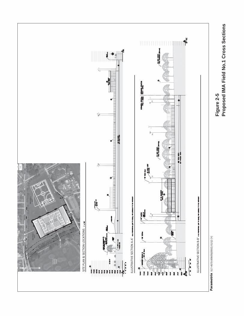
2.6.2 Site Improvements
The current configuration and use of IMA Field No. 1 would be changed by the following as indicated in Figures 2-5, 2-6, and 2-7:
The lack of formal activity areas in the current field would be replaced in the western half of the field with an artificial turf surface striped for:
o Standard soccer field use with goals to the north and south.
o Intramural soccer–flag football fields oriented in an east-west direction.
o Softball fields with baselines delineated in the northeast and southwest corners.
The east portion of the field would remain unmodified and would retain its grass turf surface. It can accommodate one soccer field or one softball field or other multi-use outdoor sport activities.
The existing field would be regraded slightly to reduce the current change in grade from an elevation of about 30 feet in the northeast corner to an elevation of 22 in the southeast corner.
Approximately 12 inches of gravel would be installed as a base underneath the synthetic surface with drains at the bottom of the gravel base.
A drainage system would be installed for the field that would discharge into University Slough south of NE Clark Road.
A new synthetic surface would be installed on the field.
Field lights would be installed consisting of eight poles with an array of 10 to 14 shielded, amiable, halide lighting fixtures with reflectors and shields designed to direct light onto the field and minimize spill-over light.
The field would be contained within a continuous 8-foot-tall black-vinyl-clad chain link fence with pedestrian and service access gates in selected locations. Behind home plate at the two softball fields, additional ball control netting (“backstops”) would extend to a total height of 20 feet for a total distance of 190 feet in each location.

517-
4570
-006
/05(
0502
) 01
/12
(Y)
Pa
ram
etr
ixF
igu
re 2
-4P
rop
ose
d IM
A F
ield
No
.1
Imp
rove
men
ts S
ite
Pla
n
517-
4570
-006
/05(
0502
) 01
/12
(Y)
Pa
ram
etr
ix
Fig
ure
2-5
Pro
po
sed
IMA
Fie
ld N
o.1
Cro
ss S
ecti
on
s

517-
4570
-006
/05(
0502
) 11
/11
(Y)
Pa
ram
etr
ix
Fig
ure
2-6
Pro
po
sed
Lig
hti
ng
Arr
ays
AB

Figure 2-7Light Fixture Detail
Draft Supplemental Environmental Impact Statement
IMA Field No. 1 Improvements| January 2012 2-13 University of Washington
2.6.3 Earthwork and Stormwater Management
Excavation and fill for the project consist of:
Site regrading, approximately 2,500 cubic yards;
Field subgrade, approximately 5,000 cubic yards; and
Final site grading outside of the synthetic surface, approximately 500 cubic yards.
It is anticipated that site cut and fill would be balanced to the extent possible. Imported or excavated materials would be transported in trucks, probably from or to a site east of Lake Washington. Truck size and quantity required to transport excavated materials would be determined by the contractor and comply with City of Seattle conditions governing hauling hours and routes. Earthwork would occur over a 3- to 5-week period, depending on trucking schedules approved by the City. Based on conditions on other projects nearby, hauling is expected to occur during the following hours:
Weekdays between 9 am and 3 pm;
Weekdays between 7 pm and 10 pm (period may be extended by City approval on a case-by-case basis); and
Weekends on a case-by-case basis.
Truck trip generation is estimated to vary depending on the extent to which cut and fill can be balanced and time allocated for excavation and the hours of hauling. Hauling of subbase material is the largest single operation and likely would require 6 to 10 trips per hour for an 8- to 10-hour work day depending on the time period in which materials are delivered.
Best management practices (BMPs) would be implemented to prevent erosion and dust and to manage stormwater during construction. A Stormwater Pollution Prevention Plan (SWPPP) would be prepared and submitted to the Washington State Department of Ecology (Ecology) in conjunction with an application for a stormwater permit.
2.6.4 Construction Timing, Sequencing, and Management
Construction would occur over approximately 2 to 4 months depending on weather conditions. Construction would begin when soil moisture conditions permit in May 2012. Construction would overlap with the Husky Stadium reconstruction, construction of the track replacement, and Sound Transit’s construction of the University Link light rail station.
Construction staging and lay down would occur either on the easterly portion of IMA Field No. 1 or in a portion of Parking Lot E4. If located in the parking lot, approximately 60 parking stalls would be temporarily displaced during construction.
Draft Supplemental Environmental Impact Statement
2-14 IMA Field No. 1 Improvements| January 2012 University of Washington
Construction operation offices would be located on the site or in Parking Lot E4. Parking for construction workers would be provided in Parking Lot E1 or E4.
Construction vehicles and equipment entering and exiting would be coordinated with the City of Seattle Department of Transportation. It is most likely that construction traffic would be oriented to State Route (SR) 520 and access the site via Montlake Boulevard, NE 45th Street, Mary Gates Drive, and NE Clark Road. It is possible that alternative routes may be approved by the City using NE 45th Street to access Interstate 5 (I-5) if access to SR 520 is not practical. It is also possible that trips may be routed to Walla Walla Road to the west, then north to NE 44th Street and Montlake Boulevard.
The following describes the activities in each of the major construction phases:
Phase I Mobilization
Segregate the construction area from public access with temporary fencing and signage. This task could include provisions for continued access to the easterly portions of IMA Field No. 1 for athletic activities during construction.
Establish access points to the construction area and install Temporary Erosion and Sediment Control (TESC) measures.
Institute construction personnel parking area.
Set up construction administration offices.
Phase II Grading
Regrade the site to reduce the slope between the northeast and southeast corners, balancing cut and fill to the extent feasible.
Install gravel-filled trenches to allow migration of landfill methane outside of the field area to dissipate through ground-level grates.
Phase III Subgrade
Install drainage system.
Install auger-cast foundations for light poles and curb around the gravel subgrade.
Install cement soil treatment to the underlying subbase of native soils.
Install subgrade of approximately 12 inches of gravel.
Install concrete curbing.
Install utilities.
Phase IV Turf Installation and Final Improvements
Install synthetic turf surface.
Install light standards and fixtures.
Install perimeter fencing.
Install grass turf in disturbed areas outside of the synthetic turf surface.
Draft Supplemental Environmental Impact Statement
IMA Field No. 1 Improvements| January 2012 2-15 University of Washington
2.7 Other Construction Projects Affecting Cumulative Impacts
2.7.1 University Village Expansion
The University Village Shopping Center has received approval for three new buildings that range from 50 to 65 feet in height with about 100,000 square feet of retail and restaurant use, as well as 713 spaces in above-grade parking garages integrated in the South Building. This building would face NE 45th Street, which is northeast of the proposed IMA Field No. 1 Improvements site.
2.7.2 Husky Stadium Reconstruction
The University of Washington is reconstructing Husky Stadium to the south of this project. Construction will take place between November 2011 and August 2013. The major route for construction hauling will utilize Montlake Boulevard to SR 520. The peak generation of truck trips from the site is projected for the winter of 2012 when demolition and excavation take place.
2.7.3 University of Washington Track Relocation
The University of Washington is constructing a new track north of Husky Stadium. Construction will take place between fall 2011 and late summer 2012. Relatively little earth movement is projected for the project, which will generally balance cut and fill. The major route for construction hauling will utilize Montlake Boulevard to SR 520.
2.7.4 Sound Transit Light Rail Station
Sound Transit is constructing a light rail connection from downtown Seattle to Capitol Hill and the University District (University Link), which is expected to open by 2016. Service is planned to reach Northgate by 2020 and Lynnwood by 2023. The University Link station will be located on a portion of the parking lot on the west side of Husky Stadium adjacent to Montlake Boulevard. Construction of the tunnel to downtown Seattle and the new station is underway and will be completed in 2016, after completion of the Husky Field improvements. The major route for construction hauling utilizes Montlake Boulevard to SR 520.
2.7.5 Montlake Triangle
A project related to the Sound Transit station includes a pedestrian overpass to take passengers across Montlake to the Montlake Triangle (between Montlake Boulevard, NE Pacific Street, and NE Pacific Place) with connections to the northeast to the Rainier Vista corridor, and to the south to the University Medical Center. NE Pacific Place will be lowered and covered to provide a pedestrian connection to the Central Campus over a land bridge aligned with Rainier Vista.
Draft Supplemental Environmental Impact Statement
2-16 IMA Field No. 1 Improvements| January 2012 University of Washington
Work on the project will be performed in three phases: Phase 1 is the construction of the pedestrian bridge, which is scheduled to be completed by Sound Transit in 2012 and 2013. Phase 2 is the Rainier Vista land bridge, to be designed and constructed by the University of Washington in 2014. Phase 3 is the landscaping, planting, and paving on the triangle by the University in 2015.
2.7.6 Evergreen Point Bridge Replacement
The Washington State Department of Transportation (WSDOT) proposes to begin construction in 2012 on the phase of the SR 520, I-5 to Medina: Bridge Replacement and HOV Project that involves replacing the Evergreen Point Bridge; completion of this phase is scheduled for 2014 (WSDOT 2010). The improvements to Field No. 1 will be substantially completed prior to major construction activities for the bridge replacement. Construction of the west approach and new pontoon bridge, including the approaches involving closure of the Lake Washington Boulevard on-ramps which would increase traffic on Montlake Boulevard, would begin in summer 2012. This work will start after completion of major excavation and foundation work on the field. The existing Evergreen Point Bridge would continue to carry traffic with few changes in configuration through completion of field construction.