(1999), toxic waste storage sites in eu countries - wwf
TRANSCRIPT

Toxic waste storage sites in EU countries A preliminary risk inventory
V.M. Sol, S.W.M. Peters and H. Aiking
IVM Report number: R-99/04
February 1999
vrije Universiteit amsterdam Institute for Environmental Studies

This report was commissioned by the WWF European Freshwater Programme.
The Project Manager was Ms J. Madgwick, WWF International, c/o WWF Denmark, Ryesgade 3F, DK-2200 Copenhagen N, Denmark.
IVM
Institute for Environmental Studies Vrije Universiteit De Boelelaan 1115 1081 HV Amsterdam The Netherlands
Tel. +31-20-4449 555 Fax. +31-20-4449 553 E-mail: [email protected]
ISBN: 90-5383-656-X
Copyright © 1999, WWF
All rights reserved. No part of this publication may be reproduced, stored in a retrieval sys-tem or transmitted in any form or by any means, electronic, mechanical, photocopying, re-cording or otherwise without the prior written permission of the copyright holder.

Preface
The present study was commissioned by the WWF European Freshwater Programme Office in Copenhagen, Denmark, as a result of the toxic spill affecting the Doñana, southern Spain in April, 1998.The project manager was Ms. J. Madgwick, WWF International.
The study was performed by Dr. V.M. Sol and Dr. S.W.M. Peters from the Institute for En-vironmental Studies (IVM) of the Vrije Universiteit in Amsterdam, the Netherlands. The IVM project leader was Dr. H. Aiking.
A large proportion of the data was supplied by helpful contributions from WWF, EEA, Wet-land International, UNEP IE, the Swedish Environmental Protection Agency, WWF Adena (Spain) and others. The authors acknowledge their support and also wish to express their gratitude to Ms. J. Madgwick for stimulating advice and feedback.


Toxic waste storage sites in EU countries i
Contents
Preface i
Executive Summary iii
Document de synthèse v
Resumen vii
1. Introduction 1 1.1 Introduction 1 1.2 Purpose of the study 1 1.3 Detailed objectives 1 1.4 Approach of the study 2
2. Scoping 5 2.1 Geographical boundaries of the study area 5 2.2 Selection of potentially vulnerable areas 5 2.3 Selection of potentially threatening activities 5 2.4 International, EU and national guidelines relevant to toxic waste storage 6 2.5 Accidents under the Seveso Directive 7 2.6 Conclusions 7
3. Mining activities 9 3.1 Introduction 9 3.2 Metal mining in Europe 9 3.3 Locations of mining activities in individual European countries 11
3.3.1 Finland 11 3.3.2 Ireland 13 3.3.3 Italy 15 3.3.4 Spain 16 3.3.5 Sweden 17 3.3.6 Other countries 19
3.4 Incidents with mining activities 20 3.4.1 Reported incidents in Europe 20 3.4.2 Reported incidents in Italy 20 3.4.3 Reported and potential incidents in Spain 21
3.5 Potential environmental impacts of mining activities 22 3.5.1 Potential environmental effects of metal mining in general 22 3.5.2 Sweden 23 3.5.3 Spain 24 3.5.4 Austria 25 3.5.5 Greece 25
WWF ii
3.5.6 Portugal 25 3.5.7 Other countries 25 3.5.8 Potential threats due to abandoned mines 25
3.6 Conclusions 25
4. Nature 27 4.1 Introduction 27 4.2 International conventions and EU legislation 27 4.3 Natura 2000 28 4.4 RAMSAR sites 28 4.5 Conclusions 29
5. Confrontation of mining activities with Ramsar sites 31 5.1 Introduction 31 5.2 Confrontation of Ramsar sites with selected metal mining locations 31 5.3 Requirements for a comprehensive European scale risk assessment 31 5.4 Recommendations for a comprehensive risk assessment 32 5.5 Conclusions 33
6. The feasibility of remote sensing for tailings detection 35 6.1 Literature study: remote sensing and mine tailings 35 6.2 A case study of the application of remote sensing and GIS techniques for tailings detection and potential risk zone assessment 37 6.3 Conclusions 39
7. Conclusions and recommendations 41
References 45
Annex 1 The main relevant national legislation in Spain, Sweden and the UK 47
Annex 2 Abandoned mines in the UK 51
Annex 3 Where to find more information 53
Annex 4 Technical details on remote sensing 55
Colour maps 59

Toxic waste storage sites in EU countries iii
Executive Summary
Sparked off by the toxic spill affecting the Doñana in 1998, the purpose of this study was to get a first impression of the environmental risk of toxic waste storage in above-ground la-goons (tailings ponds) within the fifteen European countries plus Switzerland. The study fo-cused on metal mining activities (excluding ore processing and refining) and their impacts on sensitive aquatic ecosystems.
No information was found about other major incidents of the scale that occurred at Los Frailes, affecting the Doñana wetland in southern Spain (during the last decade). However, information on major accidents from industrial installations is not readily available to the pub-lic. Literature searches revealed that there is evidence of significant pollution problems caused by leaks and spillages of acid mine water from tailing lagoons in Sweden, Spain, Italy and Portugal. There is also considerable evidence of pollution from abandoned metal mines, for example in the UK.
It was revealed that there is no central database of active or abandoned mines, location of tailings lagoons or relevant international and national legislation. It is therefore currently diffi-cult to estimate the potential scale of the environmental and human risks from spillages and leaks across Europe. Information was collected in this study by searching relevant literature and contacting relevant organisations in individual countries. The use of tailings ponds could only be confirmed for Sweden and for some mining locations in Italy, Ireland, Portugal and Spain. Finland and Greece also have significant mining activities; those of Austria and France continue to decline.
The study has concluded that there is no effective European legislative framework to protect the environment and people from pollution resulting from mining activities. Large differences exist between the planning procedures, permissions and pollution control procedures between the Member States. Moreover, national requirements in Environmental Impact Assessment concerning siting, construction methods, methods of storage and disposal, monitoring and risk assessment vary widely and local authorities have considerable discretion in giving permission for mining activities.
Wetlands (including streams, rivers, floodplains, lakes, marshes, estuaries etc.) are particu-larly vulnerable to the influence of mining activities as mines require a nearby water supply for processing the mined rock. Heavy metals and the acid water leaching from mine tailing lagoons and abandoned mine sites cause severe and long-term damage to wildlife and people. Many of the metals, such as cadmium, lead and zinc accumulate through the food chain. Comparison of the locations of known major mining sites with the location of Ramsar sites (designated as internationally important wetlands) in Europe, revealed some potentially haz-ardous situations in southern Spain and Sweden.
The Ramsar Convention, the Natura 2000 network (EC Habitats and Birds Directives) and the forthcoming EC Water Framework Directive should all encourage the identification of ex-ternal threats to wetland systems and stimulate preventative and remedial actions. However, these mechanisms are relatively indirect and the Water Framework Directive is still being de-

WWF iv
bated. There is likely to be considerable variation in the implementation of these Directives by Member States.
It is concluded that in order to protect the European environment from Doñana type calami-ties and from chronic pollution problems, there is a need for a more comprehensive risk analysis and for legislation and technical standards on all mining activities at the supranational EU level. This legislation should ensure that the relevant authorities take full account of the vulnerability of the environment within the catchments within which existing and proposed mining sites are situated.
The first step to an overall risk analysis is a time-consuming process of a country-by country approach towards all data owners, including national authorities, counties, local authorities, regulating agencies and NGOs. A pilot study has shown that this approach would be com-plemented and speeded up by careful analysis of satellite remote sensing data.

Toxic waste storage sites in EU countries v
Document de synthèse
Initiée suite au déversement toxique ayant touché le parc naturel de Doñana en 1998, cette étude a pour objectif de donner une première estimation des risques écologiques provenant du stockage de déchets toxiques dans les bassins aériens des quinze pays de l’Union européenne et en Suisse. Cette étude s'est concentrée sur les activités d’extraction minière de métaux (à l’exception du traitement et raffinage du minerai de fer) et leur impact sur les écosystèmes sensibles.
Aucune information n’a été trouvée -pour la dernière décennie- à propos d’autres accidents de l’ampleur de celui survenu à Los Frailes, qui a dûrement affecté la zone humide de Doñana, dans le sud de l’Espagne. A cet égard, il est cependant à noter que les informations concernant les accidents importants provenant d’installations industrielles ne sont pas direc-tement accessibles au public. Des études ont toutefois révélé l’existence de preuves de problèmes de pollution importants causés par des fuites ou des déversements d’eaux minières acides depuis des bassins de décantation en Suède, en Espagne, en Italie et au Portugal. Il existe également de très nombreuses preuves de pollutions provenant de mines de métaux abandonnées, par exemple au Royaume-Uni.
Il est apparu qu’il n’existe aucune base de données centrale recensant les mines et les sites de bassins de décantation en activité ou abandonnés, ni même de législation nationale ou in-ternationale gérant la question. Il est donc aujourd’hui extrêmement difficile de procéder à une évaluation des risques écologiques et humains potentiels des déversements et des fuites en Europe. Cette étude présente une compilation de l’information recueillie dans la littérature existante ainsi que via des contacts directs avec les organisations spécialisées, dans chaque pays. L’utilisation de bassins de décantation n’a pu être confirmée que pour la Suède et quelques sites miniers en Italie, en Irlande, au Portugal et en Espagne. La Finlande et la Grèce ont également des activités minières importantes, tandis que celles de l’Autriche et de la France sont en déclin continu.
La présente étude conclut qu’il n’existe aucun cadre législatif européen effectif visant à as-surer la protection de l’environnement et des populations contre la pollution résultant des ac-tivités minières. On constate aussi, entre les différents Etats membres, des différences con-sidérables au niveau des procédures de planification, d’autorisation et de contrôle de la pollu-tion. En outre, les exigences nationales d’évaluation d’impact environnemental concernant le choix des sites, les méthodes de construction, ainsi que des méthodes de stockage et de déversement, d’encadrement et de contrôle des risques présentent de fortes divergences, et les autorités locales ont souvent un pouvoir quasi-discrétionnaire dans l’octroi de permis d’activités minières.
Les régions humides (cours d’eau, zones inondables, marais, estuaires etc.) sont particulière-ment vulnérables à l’impact des activités minières, les mines requérant la proximité d’un ap-provisionnement en eau pour le traitement de la roche minée. Les métaux lourds et les eaux acides fuyant des bassins de décantation et des sites miniers abandonnés causent des dom-mages sérieux et à long terme à la faune et à la flore, ainsi qu’aux populations humaines. De nombreux métaux, tels que le cadmium, le plomb et le zinc s’accumulent au fil de la chaîne
WWF vi
alimentaire. En superposant les cartes des sites d’importantes régions minières et celles des sites Ramsar (zones humides désignées pour leur importance internationale) en Europe, on a constaté l’existence de situations potentiellement dangereuses, dans le sud de l’Espagne et en Suède.
La Convention de Ramsar, le réseau écologique Natura 2000 (établi par les Directives CE “Habitats” et “Oiseaux”) ainsi que la future Directive Cadre sur l’Eau de l’UE devraient en-courager l’identification des menaces externes planant sur les systèmes de zones humides, stimuler les actions préventives et de restauration. Cependant, ces mécanismes sont relative-ment indirects et la Directive Cadre sur l’Eau est encore en cours de débat. Il y aura probablement aussi des différences considérables dans la mise en œuvre de ces directives en-tre les Etats membres.
En conclusion, la protection de l’environnement européen contre les catastrophes, comme celle de Doñana, et contre les problèmes chroniques de pollution requiert une analyse de risque plus complète, ainsi que des standards législatifs et techniques couvrant l’ensemble des activités minières au niveau de l’UE. Cette législation supranationale devrait garantir que les autorités publiques prennent très sérieusement en compte la vulnérabilité de l’environnement dans le bassin hydrographique des sites miniers proposés.
Le premier pas en direction d’une analyse générale des risques devra être un long et lourd processus consistant à approcher, dans chaque pays, tous les détenteurs de données, y com-pris les autorités nationales, régions, autorités locales, institutions de réglementation et ONG. Une étude pilote a démontré qu’une telle démarche pourrait être complétée et accélérée par l’analyse détaillée de données recueillies par télédétection satellite.
Toxic waste storage sites in EU countries vii
Resumen
El presente estudio se llevó a cabo como consequencia después del vertido tóxico que afectó a Doñana en 1998. El objeto del mismo fue obtener una primera impresión del riesgo me-dioambiental provocado por el almacenamiento de residuos tóxicos en estanques de superfi-cie (balsas de decantacíon) , en los quince países europeos y Suiza. El estudio se concentró en las actividades de minería de metales (excluyendo el tratamiento y refinado de minerales) y sus efectos sobre los ecosistemas acuáticos sensibles.
No se ha encontrado información acerca de otros incidentes importantes (ocurridos durante la última década) de magnitud comparable a la del desastre que tuvo lugar en Los Frailes y que afectó a los humedales de Doñana en el sur de España. Por otra parte, es cierto que el público no tiene fácil acceso a la información sobre accidentes importantes provocados por instalaciones industriales. El examen de la bibliografía ha sacado a la luz problemas de con-taminación significativos causados por escapes o vertidos de agua ácida de las balsas de de-cantación de empresas mineras en Suecia, España, Italia y Portugal. Asimismo, hay pruebas considerables de contaminación provocada por minas abandonadas, por ejemplo en Gran Bretaña.
Se ha constatado que no existe ninguna base de datos central sobre las minas activas o aban-donadas, o sobre la ubicación de las balsas de decantación, ni tampoco una legislación inter-nacional o nacional adecuada. Por esta razón actualmente resulta difícil estimar la escala po-tencial de los riesgos ambientales y humanos causados por los vertidos y las fugas en toda Europa. En el presente estudio, la información se ha recopilado examinando la bibliografía relacionada con este tema y entablando contacto con organizaciones pertinentes en los difer-entes países. El uso de balsas de decantación sólo ha podido confirmarse en el caso de Suecia y en algunas zonas mineras de Italia, Irlanda, Portugal y España. Finlandia y Grecia también desarrollan importantes actividades mineras; las de Austria y Francia siguen dis-minuyendo.
El estudio ha llegado a la conclusión de que no existe ningún marco legislativo europeo eficaz para proteger a las personas y el medio ambiente contra la contaminación resultante de las actividades mineras. Se observan grandes diferencias entre los procedimientos de planifica-ción, los permisos y los procedimientos de control de contaminación de los diferentes Estados miembros. Además, los requisitos nacionales con respecto a la realización de Estudios de Im-pacto Ambiental sobre el emplazamiento, los métodos de construcción, los métodos de al-macenamiento y eliminación, el control y la evaluación de riesgos varían mucho, y las autori-dades locales tienen amplias facultades a la hora de entregar permisos para actividades min-eras.
Los humedales (incluidos torrentes, ríos, llanuras de inundación, lagos, pantanos, estuarios, etc.) son especialmente vulnerables a la influencia de las actividades mineras, dado que las minas necesitan un suministro de agua cercano para procesar los minerales extraídos. Los metales pesados y el agua ácida lixiviada procedentes de las balsas de decantación y de las minas abandonadas causan daños graves y duraderos a la naturaleza y a las personas. Muchos de los metales, como el cadmio, el plomo y el zinc, se acumulan a través de la ca-

WWF viii
dena alimenticia. La comparación entre la ubicación de importantes yacimientos mineros conocidos con la ubicación de los sitios Ramsar (lugares designados como humedales inter-nacionalmente importantes) en Europa, ha puesto de manifiesto algunas situaciones poten-cialmente peligrosas en el sur de España y en Suecia.
La Convención Ramsar, la Red Natura 2000 (Directivas de la CE relativas a la proteccíon de Hábitats y Aves) y la próxima Directiva Marco de la CE sobre el Agua deberían estimu-lar la identificación de riesgos externos para los humedales y fomentar las acciones preventi-vas y correctivas. Sin embargo, estos mecanismos son relativamente indirectos y además en estos momentos aún se está debatiendo la Directiva Marco sobre el Agua. Asimismo es probable que haya una considerable variación en la implementación de estas Directivas por parte de los Estados miembros.
Se ha llegado a la conclusión de que para proteger el medio ambiente europeo contra los de-sastres como el de Doñana y contra los problemas crónicos de contaminación, es preciso re-alizar un análisis de riesgos más amplio y fijar una legislación y unas normas técnicas para todas las actividades mineras a nivel supranacional dentro de la UE. Dicha legislación de-bería garantizar que las autoridades competentes tengan plenamente en cuenta la vulnerabili-dad del medio ambiente en la cuenca hidrográfica en la que se encuentran de los yacimientos mineros actuales y aquellos en desarrollo.
El primer paso hacia un análisis de riesgo global consiste en iniciar un la rgo proceso de reco-pilación de datos en cada uno de los países. Dichos datos deberán solicitarse, entre otros, a las autoridades nacionales, las autoridades provinciales y locales, los organismos reguladores y las ONG. Un estudio piloto ha demostrado que este enfoque podría complementarse y agilizarse si se lleva a cabo un análisis cuidadoso de los datos de teledetección por satélite.

Toxic waste storage sites in EU countries 1
1. Introduction
1.1 Introduction
On 25th April 1998, part of the tailings pond wall of the Los Frailes zinc mine near Seville in southern Spain collapsed, releasing 5 million cubic metres of acidic waste, rich in toxic metals over the next 5 days. It killed most of the wildlife in its path along the R. Guadiamar and its floodplain and affected the internationally renowned Doñana wetland and has resulted in devastating effects for local farmers and fishermen. The longer term consequences may be even more serious.
This incident was predicted by many individuals and organisations in the Doñana area and despite several official inspections of the site, it was not prevented. The results provide a dramatic illustration of the threats that are posed by the storage of toxic wastes in lagoons across Europe. WWF therefore aims to draw attention to the wider problems of storage of toxic wastes within the European Union countries, by drawing together relevant information.
1.2 Purpose of the study
The final aim of the project is to establish the environmental risks associated with the storage of toxic waste in above-ground lagoons, for example in association with mining activities, within the European Union countries. The limited study reported here, however, is primarily intended as a feasibility study and will yield a preliminary inventory of the overall environ-mental risks, plus recommendations on the approach required to achieve the overall goal.
1.3 Detailed objectives
1. To prepare an annotated map to illustrate the location of known spillages and significant leaks over the last 10 years from toxic waste lagoons; to tabulate the associated known environmental impacts and measures taken as a result of the reported incidents. This subject is treated in chapters 2 and 3.
2. To prepare an annotated map to illustrate the location and significance of known toxic waste stores (of a similar kind using above-ground lagoons) in the European Union and to show their situation in relation to “sensitive” catchments, including wetlands that are designated and candidate Natura 2000 sites. This subject is treated in chapters 4 and 5.
3. To summarise the specific environmental and human risks associated with leaks and spillages from toxic waste stores of this kind i.e. the main metals, acids, solvents used and their known and potential effects. This subject is treated in chapter.
4. To summarise the objectives, recommendations and associated measures of existing Conventions, EC Communications and Directives relevant to toxic waste stores within the European Union, and to record the status of associated national legislation (where this is required for implementation of European Directives) in each country. This subject is treated in chapters 2 and 4.

2 WWF
5. To record the problems of data availability with respect to the above tasks.
1.4 Approach of the study
Underlying rationale
Presently, the overall picture regarding the environmental risks associated with toxic waste storage in the EU is obscure, because the required information is diffuse. The present study aims to get a first impression, outlining the contours of a more quantitative assessment study. In order to quantify the overall environmental risks, scoping is required, i.e. the minimum envi-ronmental damage expected in order to be included in an actual risk assessment (estimated in a subsequent study) should be established.
Literature search
A literature search was carried out by employing commercial electronic data banks, access-ing EU data banks and by searching the Internet. However, this approach did not work for the identification and localisation of toxic waste storage sites that have not been involved in major accidents. The key focus of the study was, therefore, the retrieval of published and un-published information by contacting relevant government and non-government organisations. EU Institutions like MAHB (Major Accidents Hazards Bureau of DG XI) and EEA (Euro-pean Environmental Agency in Copenhagen), and international organisations such as UNEP and ICME (International Council on Metals and the Environment) were contacted. In addi-tion, NGOs like Greenpeace, Friends of the Earth, the Irish Peatland Conservation Council, Earthwatch, Liga para a Proteccaon da Natureza, Wetlands International and the WWF net-work were contacted by telephone, fax and email for advice on data retrieval. During the study however, it appeared that centralised information is hardly available. Therefore, infor-mation has been be collected per country, which is a time consuming task (involving numer-ous emails), also introducing language problems and a delay in data retrieval.
Remote sensing
In relation to data availability it is clear that the above approach will certainly yield results, be it incomplete data that are subject to chance. A complementary method may be remote sens-ing. Therefore, a small feasibility study was performed. Objectives of the feasibility study are to establish: (1) The potential use of remote sensing to determine the location of lakes (asso-ciated with mines) which potentially contain contaminated water. (2) Which information can be gathered concerning the type and degree of contamination. (3) If and to what extent maps can be made of surrounding areas that are vulnerable to spills of contaminated water. (4) Feasibility of collecting the retrieved information in GIS.
Structure of the report
Chapter 2 describes the approach that was used to narrow down the objectives of the study to a workable size and the EU environmental legislation. In Chapter 3 attention is given to mining activities in the EU, including incidents and potential impacts. Chapter 4 describes the

Toxic waste storage sites in EU countries 3
vulnerable sites in the EU, and Chapter 5 confronts them with the identified mining activities. The feasibility of application of remote sensing methods and establishment of a GIS-based data bank is discussed in Chapter 6. Conclusions and recommendations are given in Chapter 7.

4 WWF

Toxic waste storage sites in EU countries 5
2. Scoping
2.1 Geographical boundaries of the study area
This research addresses the situation in the 15 EU countries plus Switzerland (added on special re-quest): Austria (AUS), Belgium (BEL), Denmark (DEN), Finland (FI), France (FRA), Germany (GER), Greece (GRE), Ireland (IRE), Italy (ITA), Luxembourg (LUX), The Netherlands (NL), Portugal (POR), Spain (SPA), Sweden (SWE), Switzerland (CH), United Kingdom (UK).
2.2 Selection of potentially vulnerable areas
At this moment no European (digital) database exists of spatial data on habitats, species and pro-tected areas. The World Conservation Monitoring Centre in the UK is working on a geographic in-formation system that contains these data, but it is not yet complete.
Therefore, in consultation with WWF international it was decided on pragmatic grounds to use the information that is present in the Ramsar database at Wetlands International. It lists sites designated as internationally important under the Convention on Wetlands (Ramsar, 1971), and its Contracting Parties. It incorporates about 577 Ramsar sites in Europe and gives a relatively good overview of internationally important wetlands in Europe. Although most Ramsar sites are usually also nationally important, the converse is not true, so some nationally important wetlands may be excluded from this preliminary study.
For a subsequent study the Natural Resources CD-ROM of the European Environmental Agency should be evaluated as a potential alternative. It contains five databases from the CORINE Infor-mation System: Biotopes of major importance for nature conservation in Europe, Land cover, Coastal Erosion, Land Resources and Soil Erosion Risk. It also includes information from the Statis-tical Office of the European Commission.
2.3 Selection of potentially threatening activities
In the initial phase of the study a preliminary scoping meeting with WWF was held in order to de-cide upon the types of toxic waste to be included in the study. It was decided to cover toxic waste storage from mining activities and, if possible, large industrial installations.
Incidents from the past that have been considered involve accidents from industrial installations (Seveso Directive) and mining activities. Although accidents at sea regarding oil leakage from pla t-forms (Piper Alpha) or spills from transport of crude oil (Amoco Cadiz) can have devastating ef-fects they have not been included in this survey. Part of this information will be available Spring 1999, as IVM is carrying out a study on spills, accidents and their effects in the North Sea.
Mining activities are usually divided into mining of metalliferous ores, such as the ores of gold, iron, copper, lead, zinc, and tin, and mining of non-metalliferous minerals, such as coal, quartz, bauxite, borax, asbestos, talc, feldspar, and phosphate rock. In this preliminary inventory the research will be restricted to (heavy) metal mining, but excluding uranium. Nuclear wastes have also been excluded. Smelters will be excluded because their most important threat is air pollution. Activities to obtain substances such as natural gas and crude oil are excluded.

6 WWF
Industrial installations to which the Seveso Directive is applicable are establishments where (certain amounts of) dangerous substances are present, or likely to be produced as a result of an accident. Other industrial installations have not been taken into account.
2.4 International, EU and national guidelines relevant to toxic waste storage
International conventions
To our knowledge, there are no international conventions relevant to environment threatening activi-ties on land. Mining activities at sea are subject to international conventions, but not treated in this study. Relevant international nature protection conventions however, are considered in chapter 4.
European Union
EU environmental legislation distinguishes “horizontal legislation”, which relates to general environ-mental management issues, and legislation to specific sectors, products or types of emissions. The latter is arranged in the areas 1) air quality, 2) waste management, 3) water quality, 4) nature pro-tection, 5) industrial pollution control and risk management, 6) chemicals and genetically modified organisms, 7) noise from vehicles and machinery, and 8) nuclear safety and radiation protection. This report, however, is restricted to 4) and 5). Nature protection legislation is considered in chapter 4.
EU horizontal legislation concerns the collection and assessment of information on the environment and on the wide range of human activities with impacts on the environment. It involves the Directive on Access to Environmental Information, the Directive concerning Reporting on Implementation of Environmental Directives and the Environmental Impact Assessment Directive. The latter directive (85/337/EEC) on the assessment of the effects of certain public and private projects on the envi-ronment, has recently been amended by Directive 97/11/EC, which provisions will be put in force by March, 1999. Some categories of projects are always subject to these requirements. Examples of these projects are quarries and open-cast mining where the surface of the site exceeds 25 hectares, and installations for the production of non-ferrous crude metals from ores, concentrates or secon-dary raw materials. Smaller quarries plus smaller open-cast mining and underground mining are sub-ject to assessment when certain criteria determined by the Member States are met.
Directives and regulations on industrial pollution control and risk management cover control of in-dustrial emissions (permits), control of major hazards and environmental audits and eco-labelling. The second area is covered by the Seveso Directive 96/82/EC of 9 December 1996 on the control of major-accident hazards involving dangerous substances. This Directive (SEVESO II) replaces Directive 82/501/CEE (SEVESO I). It focuses on the protection of the environment, and is the first to introduce substances considered dangerous for the (aquatic) environment. The scope of the Di-rective has been both broadened and simplified. The Directive is applicable to any establishment where dangerous substances are present, or likely to be produced as a result of an accident, in quantities equal to or in excess of the quantities listed in the Annex. The list of named substances in the Annex has been reduced from 180 (Seveso I) to 50 and is accompanied by a list of categories of substances.
Seveso Directive 96/82/EC does not apply to the following: “military establishments; nuclear haz-ards; the carriage of dangerous substances by road, rail, air and inland waterways; the carriage of

Toxic waste storage sites in EU countries 7
dangerous substances in pipelines outside the establishments covered by the Directive; the activities of the extractive industries concerned with prospecting for, and the exploitation of, minerals in mines and quarries or by means of boreholes; waste land-fill sites”.
Directives are binding to all Member States but may contain different requirements which take into account the different environmental and economic conditions in each Member State. For example, one of the issues of an environmental impact assessment on mining is the location and method of tailings disposal (Hester and Harrison, 1994). As the EU has no technical standards on tailings con-tainment (Minewatch, 1998; Gustafsson, 1999), each country has its own procedure. In Sweden, for each site technical standards are based on individual considerations (Gustafsson, 1999).
A political and legal analysis of the basic principles of Community Environmental Policy given by Johnson and Corcelle (1997) concluded that Community Environmental Policy can be seen to repre-sent an undeniable success, despite a certain weakness. Numerous adopted directives are not ap-plied by Member States, as is shown by several cases brought before the Court of Justice in Lux-embourg. They conclude: “Finally, it is clear that legislation, although very important, could never be enough on its own to prevent certain types of pollution or accidents. To that extent the development of other means of action, particularly those involving the application of economic and financial in-struments must be a vital complement to the original command and control approach.”
National legislation
In general, large differences may exist between the planning procedures, permissions, and control of pollution between the Member States. Moreover, legislation is in general only available in the coun-tries’ own language. Therefore it is not possible to discuss environmental legislation on mining issues in all studied countries in this preliminary inventory. In the sections on mining activities in individual European countries some attention will be given to relevant aspects when available. As an illustra-tive example, annex 1 gives a short outline of the legislation relevant to mining activities in the UK, Sweden and Spain.
2.5 Accidents under the Seveso Directive
According to the Directive, the National Competent Authorities of the Member States have to notify the Commission of major accidents involving dangerous substances. Since 1984, such major acci-dents have been notified under MARS (Major Accident Reporting System), operated and main-tained by the European Commission’s Joint Research Centre (JRC), Ispra. A total of 293 accidents were reported to the MARS database (DB) from 1984 till the end of April 1997. 21 of these re-ported ecological harm as a consequence. Information on these accidents can only be extracted at JRC by the consultants of the Major Accident Hazards Bureau. As data on accidents do not include the name of the company the general public is largely dependent on newspapers for information on these accidents.
2.6 Conclusions
For the purpose of this study, the study area will be the 15 EU countries plus Switzerland.
For the purpose of this study, the areas regarded as potentially vulnerable will be those present in the Ramsar database (about 577 in Europe). For a subsequent study the CD-ROM database on

8 WWF
Natural resources by the European Environmental Agency should be evaluated as a potential alter-native.
To our knowledge, there are no international conventions pertaining to environment threatening ac-tivities on land.
According to the Seveso Directive, the National Competent Authorities of the Member States have to notify the Commission of major accidents involving dangerous substances. As the gathering of in-formation on industrial activities (including accidents) required an additional budget to contract a consultant of MAHB, industrial activities were excluded from this preliminary inventory. Moreover, data on accidents do not include the name of the company. Therefore, the general public is largely dependent on newspapers for information on these accidents.
The EU has no technical standards on tailings containment, so each country has its own procedure. In Sweden, for example, for each site technical standards are based on individual considerations.
National requirements in EIA on location, construction methods, methods of storage and disposal, monitoring and risk assessment vary widely. Moreover, the consequences of environmental legisla-tion on tailings management depends not only on the requirements and regulations, but also on how the local authorities act up to these regulations. As an illustration, the main relevant national legisla-tion in Spain, Sweden and the UK was compared. The main conclusion is that they show little or no resemblance to one another.
At present there is no common international database of technologies, register of relevant standards and regulations, or source of up-to-date information on how to use environmental tools such as pol-lution prevention laws, load-based licenses, differential taxes, and environmental management sys-tems (UNEP-IE, 1997).
In summary, the scoping phase led to the conclusion that no types of toxic wastes other than mining wastes should be included, for example nuclear wastes, dredgings, etc. Therefore, the remainder of this report deals with mining activities exclusively.

Toxic waste storage sites in EU countries 9
3. Mining activities
3.1 Introduction
Mining operations generally progress through five stages: (1) exploration, or the work involved in as-sessing the size, shape, location, and economic value of the deposit; (2) development, or the work of preparing access to the deposit so that the minerals can be extracted from it; (3) exploitation, the work of extracting the minerals and disposal of overburden and waste rock, (4) ore processing by smelting or refining, this may take place at a different location, and (5) mine closure.
Minerals are extracted from heaps of ore by pouring chemical or biological reagents over them. In the case of chemical leaching an acid or cyanide solution is commonly used (especially on ores con-taining gold or copper). In the case of microbial leaching bacteria (or algae) are used to extract minerals such as uranium, molybdenum, radium, selenium or lead from ore heaps or mine waters. In the case of in situ leaching an acid or alkaline solution is pumped through boreholes at high pressure, and often high temperature, into the mineral deposit, resulting in a slurry or solution from which the mineral can then be extracted. This is often used in uranium mining.
Tailings (or tails), the solid material left over from the ore milling process, may be stored or disposed of in a variety of ways: dumped at the mine/mill site or in specially constructed tailing ponds. The water and tailing waste from the mining and milling operations are discharged into settlement and treatment lagoons, termed “tailing ponds”. Here, the fine particles can settle and organic reagents from the milling process can biologically decompose.
3.2 Metal mining in Europe
Lumsden (1992) gives a map with locations of metal mines in Europe in 1990. In that year active metal mining existed in Austria, Finland, France, Germany, Greece, Ireland, Italy, Portugal, Spain, Sweden, and the UK.
During the 1990s, a number of these mines were closed. As a result, only 9 EU countries show metal mining activities in 1998. According to the International Council on Metals and the Environ-ment (ICME), Sweden is one of the biggest metal producers in Europe. Other significant producers are Finland, Spain and Greece (Thomas, 1998). Smaller amounts are mined in Austria, France, Ire-land, Italy and Portugal. More specific information on locations of mining activities has been searched for in different sources. The Mining Journal lists mines that presently produce more than 150,000 t/y of ore; listing gold, silver, platinum, copper, nickel, lead, zinc, bauxite and iron ore opera-tions. The result for the EU countries plus Switzerland is given in table 3.1.

10 WWF
Table 3.1. EU + CH mines that produce more than 150,000 t/y of ore; listing gold, silver, platinum, copper, nickel, lead, zinc, bauxite and iron ore operations. Source: Mining Journal, January 1998.
Mine Name Province Methods Capacity Products Tailings pond AUSTRIA Erzberg N/A N/A Iron ore ? FINLAND Hitura UG C Ni ? Pahtavaara Sodankyla OPUC D Au ? Pyhasalmi Pyhakumpu UG B Cu,Zn,Pyrite ? FRANCE La Bourneix Haute Vienne OP,UG E Au,Ag ? Salsigne Aude OP,UG C Au,Ag,Bi,Cu ? GREECE Delphoi Distomon OP,UG C Bauxite ? Euboea Euboea OP N/A Ni ? Ghiona Ghiona-Parnassos Mts OP,UG C Bauxite ? Helicon Helicon Mts OP,UG D Bauxite ? Kassandra Chalkidiki TR,UG E Au,Ag,Pb,Zn ? Larymna UG B Ni ? IRELAND Galmoy County Kilkenny UG C Zn,Pb ? Tara County Meath UG B Zn,Ag,Pb Y ITALY Furtei Sardinia OP C Au,Cu ? Masua Sardinia UG C Zn,Ag,Pb,Zn Y Monteponi Sardinia UG E Zn,Ag,Pb ? Monteveechio Sardinia UG C Zn,Pb Y Olmedo Sardinia UG D Bauxite ? Raibl Friuli Venezia Giulia UG C Zn,Pb ? PORTUGAL Aljustrel Alentejo UG B Cu,Ag,Pb,Zn ? Neves Corvo Alentejo UG B Cu,Sn,Zn Y Panasqueira Beira Baixa UG D W,Cu,Sn ? SPAIN Los Frailes Sevilla OP A Zn,Ag,Cu,Pb,Pyrite Y Filon Sur Huelva OP D Au,Ag ? Reocin Santander OP,UG B Zn,Pb,Pyrite ? Rio Tinto Huelva OP A Cu,Ag,Au,Pyrite Y Santa Elvira Jaen OP E Pb,Ag ? Sotiel Huelva UG C Zn,Ag,Cu,Pb Y SWEDEN Aitik Norrbotten OP A Cu,Ag,Au Y Björkdal Vasterbotten OP C Au Y Boliden Vasterbotten OP,UG B Zn,Ag,Au,Cu,Pb Y Enasen Gavleborg closed 1998 OP E Au,Ag,Cu Y, ? Garpenberg Dalarna UG C Zn,Ag,Au,Cu,Pb Y Kiruna UG A Iron ore Y Kristineberg Vasterbotten UG C Zn,Ag,Au,Cu,Pb Y, R Laisvall Norbotten UG B Pb,Zn Y Malmberget UG A Iron ore Y Zinkgruvan Orebro UG C Zn,Ag,Pb Y, R Method: UG=underground, OP=open pit, TR=tailings retreatment, AL=alluvial mining; Capacity: A>3.0 Mt/y, B=1-3 Mt/y, C=0.5-1 Mt/y, D=0.3-0.5 Mt/y, E=0.15-0.3 Mt/y. Tailing ponds: Y = presence of pond has been established; R= tailings pond has been rehabilitated
New projects (N) and extensions of existing operations (E), again for gold, silver, platinum, copper, nickel, zinc, lead, bauxite and iron ore, are listed in table 3.2.

Toxic waste storage sites in EU countries 11
Table 3.2. New projects and extensions of existing operations. Source: Mining Journal, January 1998.
Mine Name Province Open in Type Annual prod. Methods Cap. Products GREECE Kassandra Chalkidiki 2001 N 225,000 oz OP/UG E Au,Ag,Pb,Zn Skouries 2001 N 50,000 t OP/UG N/A Cu, Au IRELAND Lisheen County 1998 N 150,000 t UG B Zn,Pb, Ag SWEDEN Malmberget 1998 E 1.7 Mt UG A Iron ore Capacity: A>3 Mt/y, B=1-3 Mt/y, E=0.15-0.3 Mt/y; Methods: OP=open pit, UG=underground, Type: N=new, E=extension. Information on mines that produce less than 150,000 tons of ore per year is very difficult to find as an overview of all mining activities at the European level does not exist. Therefore, mining journals and conference proceedings on mining were searched for more information.
In a number of countries studied significant mining of metalliferous ores does not exist (anymore). These include Belgium, Denmark, Germany, Luxembourg, the Netherlands, Switzerland, and the UK. That means that they are excluded from this preliminary inventory on mining activities. How-ever, in a follow-up study they should be included as they have abandoned mines or may be involved in the subsequent step of ore extraction: ore processing. Ore processing may involve beneficiation, followed by metallurgical processing and refining.
Tables 3.1 and 3.2 can be used to create a map with locations of large metal mines as a first ap-proximation to locate toxic waste storage lagoons in the EU. This map is shown in figure 3.1 in the back of this report. For some countries (Finland, Ireland, Italy, Spain, and Sweden) more specific in-formation was found. This will be given in the subsequent sections.
3.3 Locations of mining activities in individual European countries
Europe’s most important role in the mining and metals industry is on the demand side of the market. Europe has a relatively small mining industry but it is a major processing centre (ASMJ, 1996). However, in this study only the mining activities are identified. In this section specific information is given on locations of metal mining activities and tailings lagoons in Finland, Ireland, Italy, Spain, and Sweden. In section 3.3.6. some general data are given of metal mining activities in Austria, Greece, France and Portugal. For an interesting overview on abandoned metal mining sites in the United Kingdom, the reader is referred to Annex 2.
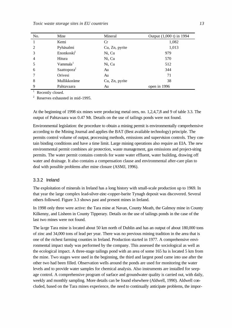
3.3.1 Finland
The supplement to the mining journal (ASMJ, 1996) lists 9 sites where metallic ores are mined, of which two were recently closed. Figure 3.2 shows the location, table 3.3 lists details of these sites.

12 WWF
Figure Fejl! Typografien er ikke defineret..2. Locations of metallic ore deposits in Finland, relative size of dots and squares relates to output, see table 3.3 for details (Based on ASMJ, 1996).
Table Fejl! Typografien er ikke defineret..3. Details on metallic ore mines in Finland (Based on ASMJ, 1996).
Toxic waste storage sites in EU countries 13
No. Mine Mineral Output (1,000 t) in 1994
1 Kemi Cr 1,082 2 Pyhäsalmi Cu, Zn, pyrite 1,013 3 Enonkoski1 Ni, Cu 979 4 Hitura Ni, Cu 570 5 Vammala1 Ni, Cu 512 6 Saattopora2 Au 344 7 Orivesi Au 71 8 Mullikkoräme Cu, Zn, pyrite 38 9 Pahtavaara Au open in 1996 1 Recently closed. 2 Reserves exhausted in mid-1995.
At the beginning of 1998 six mines were producing metal ores, no. 1,2,4,7,8 and 9 of table 3.3. The output of Pahtavaara was 0.47 Mt. Details on the use of tailings ponds were not found.
Environmental legislation: the procedure to obtain a mining permit is environmentally comprehensive according to the Mining Journal and applies the BAT (Best available technology) principle. The permits control volume of output, processing methods, emissions and supervision controls. They con-tain binding conditions and have a time limit. Large mining operations also require an EIA. The new environmental permit combines air protection, waste management, gas emissions and project-siting permits. The water permit contains controls for waste water effluent, water building, drawing off water and drainage. It also contains a compensation clause and environmental after-care plan to deal with possible problems after mine closure (ASMJ, 1996).
3.3.2 Ireland
The exploitation of minerals in Ireland has a long history with small-scale production up to 1969. In that year the large complex lead-silver-zinc-copper-barite Tynagh deposit was discovered. Several others followed. Figure 3.3 shows past and present mines in Ireland.
In 1998 only three were active: the Tara mine at Navan, County Meath, the Galmoy mine in County Kilkenny, and Lisheen in County Tipperary. Details on the use of tailings ponds in the case of the last two mines were not found.
The large Tara mine is located about 50 km north of Dublin and has an output of about 180,000 tons of zinc and 34,000 tons of lead per year. There was no previous mining tradition in the area that is one of the richest farming counties in Ireland. Production started in 1977. A comprehensive envi-ronmental impact study was performed by the company. This assessed the sociological as well as the ecological impact. A three-stage tailings pond with an area of some 165 ha is located 5 km from the mine. Two stages were used in the beginning, the third and largest pond came into use after the other two had been filled. Observation wells around the ponds are used for monitoring the water levels and to provide water samples for chemical analysis. Also instruments are installed for seep-age control. A comprehensive program of surface and groundwater quality is carried out, with daily, weekly and monthly sampling. More details can be found elsewhere (Aldwell, 1990). Aldwell con-cluded, based on the Tara mines experience, the need to continually anticipate problems, the impor-

14 WWF
tance of direct assessment of heavy metal impacts on biological systems and the importance of good relations and communications with the public for a mine in a populated area.
Toxic waste storage sites in EU countries 15
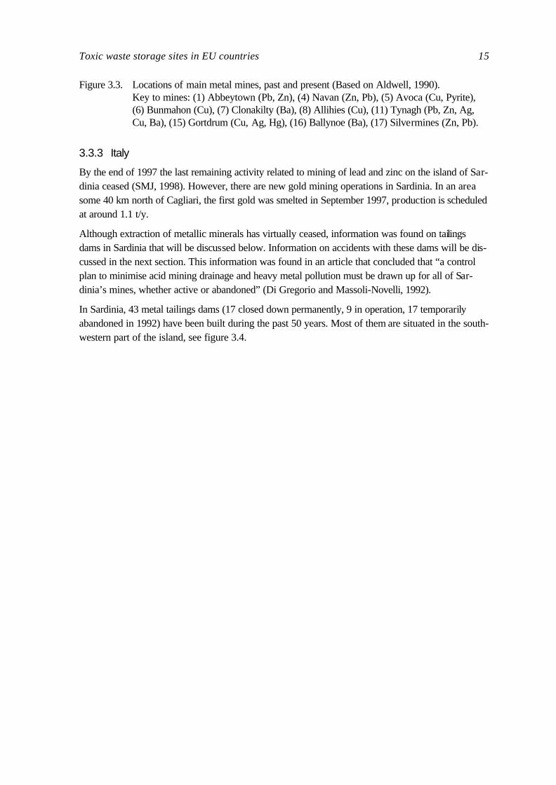
Figure 3.3. Locations of main metal mines, past and present (Based on Aldwell, 1990). Key to mines: (1) Abbeytown (Pb, Zn), (4) Navan (Zn, Pb), (5) Avoca (Cu, Pyrite), (6) Bunmahon (Cu), (7) Clonakilty (Ba), (8) Allihies (Cu), (11) Tynagh (Pb, Zn, Ag, Cu, Ba), (15) Gortdrum (Cu, Ag, Hg), (16) Ballynoe (Ba), (17) Silvermines (Zn, Pb).
3.3.3 Italy
By the end of 1997 the last remaining activity related to mining of lead and zinc on the island of Sar-dinia ceased (SMJ, 1998). However, there are new gold mining operations in Sardinia. In an area some 40 km north of Cagliari, the first gold was smelted in September 1997, production is scheduled at around 1.1 t/y.
Although extraction of metallic minerals has virtually ceased, information was found on tailings dams in Sardinia that will be discussed below. Information on accidents with these dams will be dis-cussed in the next section. This information was found in an article that concluded that “a control plan to minimise acid mining drainage and heavy metal pollution must be drawn up for all of Sar-dinia’s mines, whether active or abandoned” (Di Gregorio and Massoli-Novelli, 1992).
In Sardinia, 43 metal tailings dams (17 closed down permanently, 9 in operation, 17 temporarily abandoned in 1992) have been built during the past 50 years. Most of them are situated in the south-western part of the island, see figure 3.4.
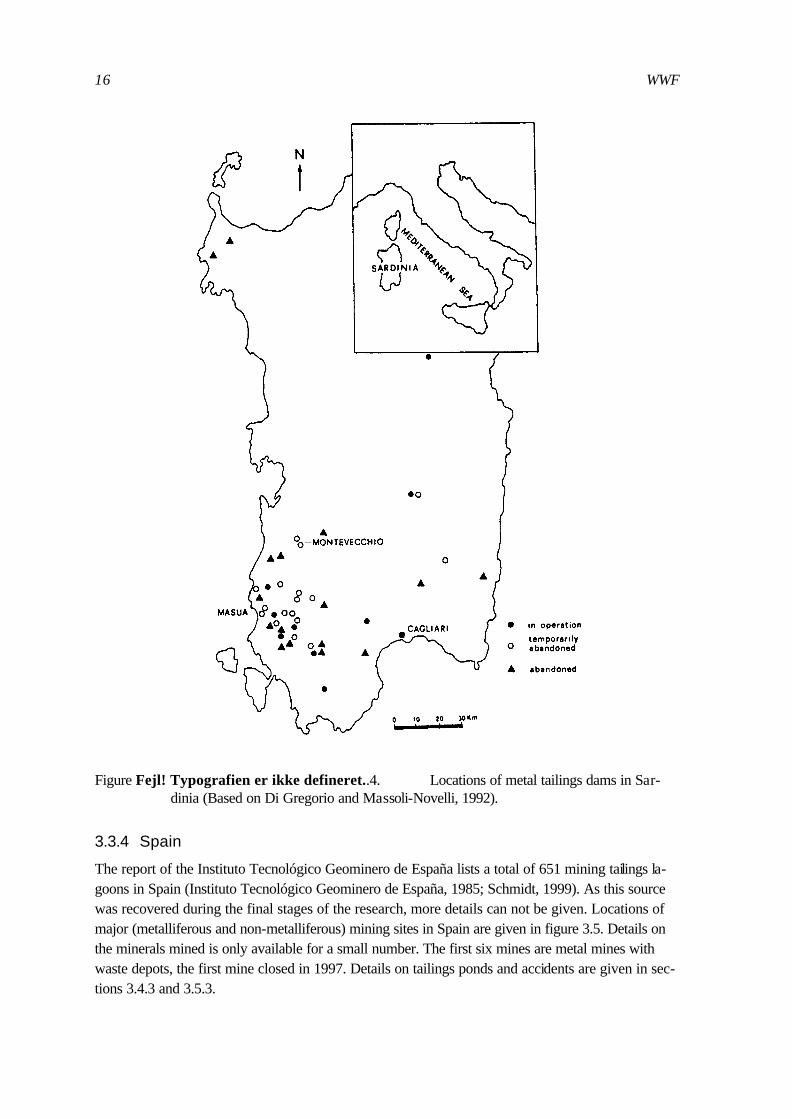
16 WWF
Figure Fejl! Typografien er ikke defineret..4. Locations of metal tailings dams in Sar-dinia (Based on Di Gregorio and Massoli-Novelli, 1992).
3.3.4 Spain
The report of the Instituto Tecnológico Geominero de España lists a total of 651 mining tailings la-goons in Spain (Instituto Tecnológico Geominero de España, 1985; Schmidt, 1999). As this source was recovered during the final stages of the research, more details can not be given. Locations of major (metalliferous and non-metalliferous) mining sites in Spain are given in figure 3.5. Details on the minerals mined is only available for a small number. The first six mines are metal mines with waste depots, the first mine closed in 1997. Details on tailings ponds and accidents are given in sec-tions 3.4.3 and 3.5.3.

Toxic waste storage sites in EU countries 17
Figure 3.5. Locations of major mining sites (not just metals; see text) and most dangerous tailings ponds in Spain (Based on EL PAíS, 1998). Key to mines: (1) Los Frailes, (2) Aznalcól-lar, (3) Tharsis, (4) Sotiel Coronada, (5) Rio Tinto, (6) A Coruña, (7) Belmonte de Miranda, (8) San Juan de Nieva, (9) Mutiloa, (10) Almonaster La Real, (11) Filon sur, (12) Castuera, (13) Rielves, (14) Morille, (15) Xinzo de Limia, (16) Catoira, (17) So-brado, (18) Toreno, (19) Soto y Amio, (20) Carrocera, (21) Aviléz, (22) Guardo, (23) Muda, (24) Camaleño, (25) Udias, (26) Suances, (27) Camargo, (28) Maestu, (29) Miranda de Ebro, (30) Valle de Oca, (31) Ibeas de Juarros, (32) Alfaro, (33) Qiarzun, (34) Vilaller, (35) Osor, (36) Bellmunt, (37) Onteniente, (38) Cartegena, (39) Mazar-ron, (40) Cuevad de Almanzora, (41) Níjar, (42) Almocita, (43) Berja, (44) La Caro-lina, (45) Alcarecejos, (46) Mestanza, (47) Villamayor de Calatrava, (48) Abenojar, (49) Marbella.
3.3.5 Sweden
Figure 3.6 shows the location of the active mines in Sweden (Geological Survey of Sweden, 1998). Mines 3 and 4 are iron ore mines, 1 and 2 are recently closed. That leaves 11 mines that are active in June 1998. Other details on these mines are given below:

18 WWF
Figure 3.6. Location of the mines in Sweden, see table 3.5. for details (Based on Geological Sur-vey of Sweden, 1998).

Toxic waste storage sites in EU countries 19
Table Fejl! Typografien er ikke defineret..4. Details on active metallic ore mines in Sweden (Based on Geological Survey of Sweden, 1998).
No. Mine Mineral Operation Output/y (kt)
5 Autik Cu, Au Open pit 16,300 6 Laisvall Pb, Zn Underground 1,750 7 Kristineberg Cu, Ag, Au, Zn, Pb Underground 470 8 Åkerberg Au Open pit →Underground 140 9 Björkdal Au Open pit 950 10 Petiknäs Au, Zn, Cu Underground 330 11 Renström Au, Au, Zn, Cu, Pb Underground 200 12 Kankberg Au, Zn, Cu Underground 330 13 Långdal Au, Zn, Cu Underground 330 14 Garpenberg Zn, Pb Underground 900 15 Zinkgruvan Zn, Pb Underground 650
Pahtohavare, (2) Viscaria, (3) Kiruna, (4) Malmberget
All mines had tailings ponds in 1996 (Gustafsson, 1999). Today the tailings pond at Kristineberg is being rehabilitated. Enasen (in Gavleborg) is closed and a new mine is Woxna Grafit (in Gavleborg) with sulphidic minerals. This mine also has a tailings pond. According to the Swedish Environmental Protection Agency all mines and tailings ponds are situated close to wetlands, streams and lakes. Some of these areas are protected for nature conservation purposes. Potential threats of tailing ponds are discussed in section 3.5.2.
From 1978, Sweden’s environmental legislation provided for/ensured that any economic growth must be sustainable and made without fierce exploitation of resources or damage to the ecological balance.
Aitik (Boliden) is Sweden’s largest gold mine (a by-product of copper) and one of Europe’s largest open pits. Waste rock is dumped 4 km away, “tailings are pumped to a 5 km long by 1.5 km wide tailings dam, which feeds into a clean water settling pond. All process water is recycled from this facility. However, more water is collected here than is required by the plant so some 2 million m3 of clear water is released into the local river system every summer.” In 1985 2,000 kg/y of copper went into the river by this water, in 1995 it was only 10 kg (Mining Magazine, July, 1996).
3.3.6 Other countries
Austria
In 1998 only one iron ore mine is still operating. There are no new activities as regards to metal min-ing. Given the economic geology of the Austrian Alps, the chances of finding new and workable mineral deposits are considered remote (SMJ, 1998).
France
The mining industry in France continues to decline, exemplified by the closure of the last iron ore mine, the Terres Rouges mine at Audin. Also the production of uranium is falling, the production fell to 580 t in 1997 against 840 t in 1996. France’s gold mines produced 4.5 t, with 2.7 by the Salsigne

20 WWF
mine and 1.8 t by the Bourneix mine (SMJ, 1998). Details on the use of tailings ponds could not be established.
Greece
Other then some details on amounts of metals produced no extra information was found on metal mines in Greece.
Portugal
Portugal has three major metallic ore mines: the Aljustrel mine, the Neves Corvo mine and the Panasquira mine (northern Portugal). The country attracts interest for further mining activities as it has some 18 prospecting contracts on metallic resources (SMJ, 1998). According to the Liga para a Proteccaon da Natureza (LPN) the copper mines of Somincor in Castro verde (Neves Corvo) use a big tailings pond to store inorganic sludge with flocculent agents used in the treatment of the ore. It contains traces of various metals (Cu, Pb, As, Sb, Bi, Ag, Hg). The amount of waste increased 3 times since 1993 and was 1,467,009 ton in 1997 (Faria, 1998). Other details on the use of tailings ponds could not be established.
3.4 Incidents with mining activities
3.4.1 Reported incidents in Europe
In 1996 Mining Journal Research Services completed a study at the request of the United Nations Environment Programme (UNEP) on the occurrence of reported failures and other similar incidents involving mine tailings dams in major mining regions during the years since 1980 (UNEP/DHA, 1996). There is, however, no centralised source for information about tailings dam incidents. In the USA two organisations are collecting data on incidents, but these mainly involve incidents in the USA. The UNEP report concluded that the level of public reporting and discussion following a ma-jor incident is extremely variable. Regulations regarding construction methods for tailings dams and requirements for reporting incidents vary from country to country.
On behalf of the UNEP/DHA study requests for information were made to the authorities of France, Germany, Poland and Sweden. No information was received from the three former coun-tries, and respondents in Sweden reported no incidents. It is concluded that in general, mining in Europe is dominated by coal and construction materials, neither of which typically call for large tail-ings dams (UNEP/DHA, 1996).
According to the report, tailings from the French uranium mining probably hold the greatest potential for environmental concern, but the lack of records of any incident suggests that controls are both adequate and well enforced.
3.4.2 Reported incidents in Italy
The UNEP/DHA study (1996) identified one incident in Italy, the Stava incident on July 19th, 1985. The 23 years old Stava tailings dam in the Trento region collapsed, causing 268 fatalities and exten-sive environmental damage. The mine was a fluorite mine.

Toxic waste storage sites in EU countries 21
In Sardinia, Italy, 43 metal tailings dams have been built during the past 50 years, see figure 3.4. Over the past 30 years “flow slides” (caused by tailings moved by exceptional, concentrated rain-fall) occurred at the mines of Mont’Ega, Buggerru, Funtana Ramonosa, Rosas, and Su Zurfuru. In the case of abandoned basins, the most serious problems have been caused by accelerated erosion deriving from both wind and water. High concentrations of heavy metals were e.g. found in the river sediments of the Sa Duchessa and Barraxiutta mines (Di Gregorio and Massoli-Novelli, 1992).
The Masua mine is an important lead-zinc deposit, and has two tailings dams, an older one covering an area of 5 ha and a more recent one, of which the basin covers an area of 7 ha. The dams are situated near the coast. To keep surface water pollution to a minimum, in recent years percolated water from the tailings dams has been accumulated in a pond. From there, the water is pumped to a washery and reused. In 1978 there was a failure of the older dam, which caused serious sea water pollution. Since that time the dams of this mine have been improved in slope and thickness, and later the dams were closed (Di Gregorio & Massoli-Novelli, 1992).
3.4.3 Reported and potential incidents in Spain
The UNEP/DHA report (1996) mentions a sand slide into a Spanish open pit iron ore mine in the mid-1980s, but that resulted from a failure of an overburden dump.
On behalf of the Spanish mining directorate the technical geo-mine institute inspected all 661 mine tailings lagoons between 1984 and 1988 (Instituto Tecnológico Geominero de España, 1985). In 168 cases instability was reported and in 160 cases water catchments and rivers were polluted. The re-port warned about the tailings pond of Aznacóllar: “Su gran volumen exige un seguimiento de la evolución de la estructura” [the large volume demands a close monitoring of the development of the construction]. The report states about the copper mining of Riotinto: “Es una estructura muy grande e impactante con el emtomo. Contamina los acuíferos superficiales. El muro es una auténtica presa de tierra. Quizás sobredimensionada.” [A very large construction with important impact on the envi-ronment. Pollutes surface water. The dam is a real clay wall. Possibly too big]. The wall of the tail-ings pond of Oyarzun (Guipúzcoa) was reported to be strongly eroded and very weak. And there are many more. But, as this was the last inventory, the Ministry of Environment and the General Di-rectorate of Mines do not have recent information on the danger of tailings lagoons, according to Peregil (1998).
Peregil reported that, according to the environmental organisations in Spain, at least 7 tailings ponds throughout the country pose a danger that is comparable to Aznacóllar. Details on these ponds are given below and in figure 3.5. In the province of Murcia 30 tailings dams of abandoned mines have been selected for repair, but money is lacking. In august 1960 in the area Torrelavega y Reocín in Asturia, the wall of the tailings pond (80,000 m2 surface) of Asturiana de Zinc cracked in several places, releasing a mud stream that lasted only 3 minutes. Eighteen people were killed, the cause is as yet unknown.
The Doñana incident, which was caused by a tailings impoundment failure at the Los Frailes mine in April 1998, affected a large area. A total of 6.8 million, comprising of 1.3 million m3 of solids and 5.5 million m3 of water were released from the breach inundating the Rio Agrio, Rio Guadiamar and surrounding agricultural land and threatening the Doñana wetland. The Spanish farmers union ASAJA, which represents 95 % of the farmers in the area, claims that the tailings have inundated 3,000 ha of farmland with sludge and affected more than 5,000 ha (Sassoon, 1998). The ecological

22 WWF
effects on the Doñana wetland were severe, and much of the directly affected area is used by breeding and migratory birds. The long term effect of heavy metal contamination of water, soils and vegetation and the possibility of sub-lethal effects such as poor reproduction, as a result of bio-accumulation in the food chain, are hard to estimate. More information can be found elsewhere (Biblioteca de la Universitat de Barcelona, 1999). In so far, the stories of contamination of the sur-face and ground water in the whole region have resulted in a 30-35% drop in market price for prod-ucts and a 10% drop in visitors to the Doñana National Park.
At the end of 1998 another incident happened in the Huelva province (Rio Tinto valley). The dam of a storage lagoon of a fertiliser plant broke under stormy weather conditions. The 70 hectare big pond stores acidic waste water, prior to treatment. According to official data some 50,000 m3 was released, according to ecologists more than 500,000 m3. A local NGO had warned for the risk of that lagoon and illegal filtrations to the nearby Tinto Marshlands (Schmidt, 1999).
3.5 Potential environmental impacts of mining activities
3.5.1 Potential environmental effects of metal mining in general
Mining activities have a wide range of environmental impacts at every stage of operations. Man-agement of tailings is one of the most significant environmental aspects of mining operations (World Bank, 1998). Failure of tailings containment can have serious adverse environmental consequences. Major potential environmental problems associated with mining projects are listed in table 3.5.
As can be seen from this table, mining activities can be the source of both acute pollution, releasing large, often concentrated amounts in a short time (due to accidents) and diffuse pollution, a rather constant emission of relatively low concentrations during a long time.
As to the effects of heavy metals and acidic discharges into the aquatic environment as a result of mining activities, a large number of publications exist. For instance, Kelly (1991) reviews studies on accumulation and toxicity of nickel, copper, lead and zinc in plants and animals both in field and laboratory studies. Emissions to aquatic ecosystems usually have many sublethal long-term effects, including on reproduction. The results may vary from a decrease in abundance to extinction of cer-tain species (Sengupta, 1994).
Water from active mines is normally discharged in a controlled manner, but waters from abandoned mines are in general discharged without controls and are a source of poor water quality. In addition to direct downward movement of rainwater reaching the underlying aquifers, water may also enter via faults, galleries, and horizontal entrances (adits). The chemical nature of such waters varies from mine to mine, but a common feature is the presence of iron pyrites which, upon prolonged con-tact with water, dissolve (under the influence of bacteria) to form sulphuric acid. This acid may then cause other minerals to dissolve. The final waters emerging from a mine are therefore often acidic, laden with metals such as copper, cadmium and zinc. It is these dissolved heavy metals that consti-tute the main danger of metal mining, due to their extreme toxicity to all forms of life. Whole librar-ies exists on the toxicity of heavy metals and many series of bi-annual conferences are devoted to the subject, like the International Conference on “Heavy metals in the environment” (e.g. Wilken et al., 1995).

Toxic waste storage sites in EU countries 23
Table Fejl! Typografien er ikke defineret..5. Potential environmental impacts of mining (Based on UNEP-IE, 1997; World Bank, 1998).
Environmental impacts
Destruction of natural habitat at the mine site and waste disposal site Destruction of adjacent habitats as a result of emissions and discharges Destruction of adjacent habitats arising from influx of settlers Changes in river ecology due to siltation and flow modification Alteration of water tables Change in land form Land degradation due to inadequate rehabilitation after closure Land instability Danger from failure of structures and dams Abandoned equipment, plant and buildings
Pollution impacts
Drainage from mining sites, including acid mine drainage Sediment run-off from mining sites Pollution from mining operations in riverbeds Effluent from mineral processing operations Sewage effluent from the site Oil and fuel spills Soil contamination from treatment residues and spillage of chemicals Pollutants leached from tailings, disposal areas and contaminated soils Air emissions from mineral processing operations Dust emissions from sites near living areas or habitats Release of methane from mines
Occupational health impacts
Handling of chemicals, residues and products Dust inhalation Fugitive emissions within the plant Air emissions in confined spaces from transport, blasting, combustion Exposure to asbestos, cyanide, mercury or other toxic materials Exposure to heat, noise, vibration Physical risk at the plant or site Unsanitary living conditions
Resource Issues
Effects on ground water and surface water resources Effects on fisheries Loss of forestry resources Agricultural land losses
3.5.2 Sweden
The major threats of (abandoned) tailings ponds are against the closest streams and to the Dalälven River, lake Vättern, lake Mälaren and Skellefteälven (Gustafsson, 1999). An overview of aban-doned tailings ponds that still show severe leakages of Cu, Zn, Pb and Cd (due to acid mine drain-age) is given in table 3.6.

24 WWF
Table Fejl! Typografien er ikke defineret..6. Abandoned tailings ponds that still show severe leakages of Cu, Zn, Pb and Cd (Source: stafsson, 1998).
Name of mine with abandoned tailings pond Province Rehabilitated ponds
Zinkgruvan (4 ponds) Orebro Y, one Garpenberg (4 ponds) Dalarna N Kristineberg (4 ponds) Vasterbotten Y, three Saxberget Dalarna Y Falun (2 ponds) Dalarna Y, one Adak Vasterbotten Y Laver Norbotten N Bersbo Otgotland Y
The first full scale project in Sweden to abate acid mine drainage from old mining activities is Bersbo. After 600 years of copper mining, mining activities ceased in the early 20th century. The ore was smelted in a plant some 8 km away. The waste left in Bersbo is waste rock (1,400,000 ton-nes total) that was disposed of in several heaps spread over a large area and a small tailings pond (15 kton). This area is very close to lake Grunvsjön, and also lake Risten and lake Stralangen re-ceive water with concentrations of copper, zinc and (low) cadmium. In 1989 all deposits were cov-ered. The resulting decrease in water percolation and decrease in oxygen concentration (leading to a decrease in oxidation of sulphides, and so to less dissolved metals) should lead to a total reduction of metal transport of at least 99,8% (Sengupta, 1993).
3.5.3 Spain
Spain has a large number of tailings lagoons that may pose a threat to vulnerable sites. However, in-formation is very difficult to find. Schmidt (1999) provided details from a report of the Andalusian Regional Ministry of Environment (1994) that identified at least six metal mines that had waste de-pots, but it is not clear whether tailings ponds are present. A global overview of the most important threatening ponds (based on local NGOs) have been reported by Peregil in the newspaper EL PAíS (June 7, 1998). According to Peregil Spain has seven threatening tailings ponds:
Three in Huelva: In Sotíel Coronada (municipality of Calañas) water flows over the brim of the tail-ings dam during heavy rainfall via the El Batán into the river Odiel. The last part of this river flows through an important nature reserve (Parque Natural de las Marismas del Odiel). According to a four year old inventory of the Council of Andalusia four mines pose an “important” and “consider-able” impact on the water. These four are the mines of Aznacóllar (closed in 1997), Sotiel Coro-nada, Tharsis and Riotinto.
Touro (A Coruña), a copper mine, which was abandoned 11 years ago by the company Rio Tinto Minera. The rivers in the area, de Brandelos en de Lañas, are very polluted. These rivers supply water to the Ulla, that runs into the tidal river Arousa. The level of pollution of these rivers did not change over the last ten years. People are advised against using the water, even after intensive pu-rification.
Two in Asturia: The tailings pond of the recently (this year) opened gold mine in Belmonte de Hi-randa, 68 km of Ovideo, is a time bomb for the neighbouring Narcea river. The dam shows leaks, the area experienced seismic activities and the pond is situated on a high location. The other dan-

Toxic waste storage sites in EU countries 25
gerous pond is situated 1 km of the beach of Salinas in San Juan de Nieva. The zinc production company has 3 tailings dams, the oldest dates from 1957 and stores jarosite. Because they still have not found a useful application of the jarosite, it is dumped into the sea, according to a local NGO.
Mutiloa, in Guipúzcoa: in the Basque Provinces, the pond of Mutiloa can pose a threat to the rivers Oria and Estanda. In 1995 water was flowing from the mine to these two rivers and polluting them. After this incident, a layer of soil was brought on top of the waste, to prevent oxidation of the sul-phur compounds. In the same province some 80 other tailings dams have to be examined, but, again, money is lacking.
3.5.4 Austria
According to the Austrian Environmental Agency they do not know of any threats to nature by con-crete impacts of contaminated sites (abandoned and operating mining waste sites and industrial sites).
3.5.5 Greece
Although mining sites are in general close to water and may pose a threat to vulnerable areas no in-formation was found on this issue. According to the contact of WWF-Greece, non of the active mining sites in Greece from table 3.1 are close to a big wetland or Ramsar site. The basic known threats to Ramsar sites in Greece are agricultural run-off and/or domestic waste.
3.5.6 Portugal
An example of a potential threat by a Portuguese mining site was reported by Ferreira et al. (1990). They measured heavy metals, PCBs and DDT in an oyster species that is native to Portugal and that occurs mainly in the intertidal areas of the upper and middle Sado Estuary. Sources of these pollutants were the River Sado, that drains an active pyrite area and a large industrial area. The oysters accumulated both metals and organochlorines, at rates depending on both biological and en-vironmental factors.
3.5.7 Other countries
No information was found on threats of mining activities in Finland, France, and Ireland.
3.5.8 Potential threats due to abandoned mines
Although the impact of the untreated mine water of abandoned mines may be severe, it is very dif-ficult to access data on abandoned mines. Therefore, little attention was given in this report to that subject. However, in a subsequent investigation abandoned mines should be taken into account. To give an indication of the magnitude of the problem, data were collected for one country. Therefore, the reader is referred to Annex 2 for some information on abandoned mines in the UK.
3.6 Conclusions
An overview of metal mining activities at the European level does not exist. The same applies to abandoned mines. In the latter case an overview may not even exist at the national level. Data on

26 WWF
active and abandoned mines have to be collected by hand in a time-consuming process by searching the relevant literature and contacting relevant organisations for each individual country, as has been done for the present report. Additional sources can be found in Annex 3. And then again, the pre-sent report is only a first step; the present data are far from complete, consistent and up-to-date yet. Confirmation in a follow-up study is required.
Europe has a relatively small mining industry but it is a major processing centre. Sweden is one of the biggest metal producers in Europe. Other significant producers are Finland, Spain and Greece. Smaller amounts are mined in Austria, France, Ireland, Italy and Portugal. In Italy extraction of me-tallic minerals has virtually ceased. In France the mining industry continues to decline and the same is true for Austria. In all other countries production is zero.
At present there is no common European register on tailings ponds nor on incidents with mine tail-ings dams. In 1982 the International Commission on Large Dams (ICOLD) published a first edition of a World register of Mine and Industrial Tailings dams, but this was far from complete. This can be illustrated by the entry for Britain which contains only 7 dams, even though the (UK) National Coal Board indicated in 1984 that it owned about 400 tailings lagoons, with 7 covering an area ex-ceeding 10 hectares, 118 have areas between 1 and 10 hectares and the others are smaller than 1 hectare (Penman, 1985).
In Sardinia, Italy, 43 tailings dams have been built during the past fifty years, but at least 17 of them were closed down permanently in 1992. The location of these lagoons could partly be established. The status of these dams in the year 1998 (in use, closed, rehabilitated) is not certain. Over the past ten years no major incidents have been reported with metal mining sites. In earlier times several flow slides occurred and in 1978 a failure of a dam resulted in serious sea water pollution.
In 1985 some 560 tailings lagoons (not all belonging to metal mines) were listed in Spain. In 168 cases instability was reported and in 160 cases water catchments and rivers were polluted. Today, at least 7 tailings lagoons pose a severe threat to vulnerable areas, although no major breaches of tailings dams have been reported, other than the Doñana incident.
In Sweden, all metal mining sites have confirmed tailings lagoons. Abandoned tailings lagoons are rehabilitated or due to be rehabilitated, some of which show severe leakages of heavy metals due to acid mine drainage. No incidents involving tailings dams have been reported.
In Portugal, a native oyster species that lives close to an active mine area, was reported to be threatened by heavy metals.
The use of tailings lagoons could not be confirmed for Austria, Finland, France and Greece. In the case of Ireland and Portugal confirmation was established for only one of the three active mining sites. No information on breaching of tailings dams was found for these 6 countries.
Regulations regarding requirements for reporting incidents vary from country to country.
Toxic waste storage sites in EU countries
27
4. Nature
4.1 Introduction
As water is both a vital raw material for the processing of ore, and a major waste stream, mining activities are usually located near rivers or lakes. Moreover, the aquatic environment, which in-cludes rivers, lakes, groundwater and all kinds of wetlands, is most vulnerable to heavy metal con-tamination. Areas that are most highly valued for biodiversity are protected by a range of interna-tional and European conventions, EU legislation and national legislation, which are discussed blow.
4.2 International conventions and EU legislation
A large number of international and European conventions on nature conservation exists, e.g. the Rio Convention on the conservation of biological diversity (1992), the Bonn Convention on migratory species (1979) and the Ramsar Convention on the conservation of wetlands (1971). More details on all relevant global, European and regional initiatives for nature convention can be found elsewhere (Johnson and Corcelle, 1997; Stanners and Bourdeau, 1995). The Ramsar Convention will be dis-cussed in more detail in section 4.3.
The most important EU legislation on nature protection comprises two Directives: the Birds Direc-tive (79/409/EEC) and the Habitats Directive (92/43/EEC). Under the Birds Directive, 1,600 sites have been classified as Special Protection Area, covering a surface area of more than 100,000 km2. The Habitats Directive is the main Community instrument safeguarding biodiversity. Member States have to identify and designate Special Areas of Conservation sites which are important for the pro-tection of the species and habitats (200 types, including peat bogs, coastal and freshwater habitats, dunes, etc.) covered by the Directive. Together these areas will make up the European network of protected sites, Natura 2000.
In consequence of the above conventions and directives, all EU countries have passed legislation for the protection of certain sites of importance to the conservation of nature as ‘protected areas’. The titles and status given to such areas at the national level in Europe vary greatly, however. There is national legislation to establish biogenetic, forest, wildlife, and marine reserves, nature parks, pro-tected landscapes and others. Unfortunately, the same name means different things in different countries.
With regard to the protection of ecosystems, and aquatic ecosystems in particular, the Proposal for a Council Directive establishing a framework for community action in the field of water policy (the Water Framework Directive), COM (97)49 and COM (98)76, is also important. For each river ba-sin, Member states must co-ordinate their actions, integrating all the existing water policy measures. The results of all these actions must be set out in a river basin management plan which will be de-veloped with full public participation. The Proposal contains, in its Annex V, a general outline for technical specification for definition, classification and monitoring of the ecological and chemical status of surface waters and quantitative and chemical status of groundwater. Monitoring of pro-tected areas has been given a special reference. However, this does not yet give any protection against external threats from nearby locations, such as Doñana-type incidents.

WWF
28
4.3 Natura 2000
National governments have to establish conservation measures such as management plans, specially designed for the sites concerned or integrated into other development plans. Each Member State is free to choose the method and type of measures to be taken. But whether statutory, administrative or contractual, they must prevent any deterioration of the site and if necessary restore them. Once a Natura 2000 site has been designed any plan or project (including existing ones) which is likely to have a significant effect on the site, either individually or in combination with other plans or projects, must be subjected to an appropriate environmental assessment of its implication in view of the site’s conservation objectives (according to Article 6 of the Habitats Directive). If the activity will ad-versely affect the site, and there are no alternative solutions, the activity concerned may only be carried out if it is declared to be of major public interest. Member State must then take all required compensatory measures and inform the Commission thereof. Where the site concerned hosts a pri-ority natural habitat type and/or a priority species, the only considerations which may be raised are those relating to human health or public safety, to beneficial consequences of primary importance for the environment, or further to an opinion from the Commission, to other imperative reasons of overriding public interest.
The status of the Natura 2000 network is regularly reported upon in the European Commission DG XI’s Nature Newsletter. In June 1998 it reported that for some countries the first phase, proposing national lists of sites, is still not complete. In stage two, Sites of Community Importance will be cho-sen by the Commission, in close association with the European Topic Centre for Nature Conserva-tion. By means of seminars scientific consensus on the Community list and the mechanism of selec-tion is sought. WWF is constructing a “shadow list” of national proposals for protected areas (Natura 2000) in EU but also this database has not yet been completed.
The implementation of the Birds Directive has been given a clear impetus by the judgement of the Court of Justice in Case C-3/96, the Commission versus Netherlands, supported by Germany, May 1998. The judgement involved the important conclusion that the classification as SPA of the most suitable territories in number and size for the conservation of species is an obligation which is not possible to avoid by adopting other conservation measures. In addition, economic requirements may not be taken into account when selecting an SPA and defining its boundaries. The implications of this judgement are large. Only Belgium and Denmark have largely met this requirement even though the Birds Directive was adopted almost 20 years ago. Legal procedures for insufficient SPA classi-fication are underway against several other Member States (Natura 2000 Newsletter, 1998).
4.4 RAMSAR sites
The Convention on Wetlands is an intergovernmental treaty adopted on 2 February 1971 in the Ira-nian city of Ramsar, on the southern shore of the Caspian Sea. The official name of the treaty – The Convention on Wetlands of International Importance especially as Waterfowl Habitat – reflects its original emphasis on the conservation and wise use of wetlands primarily to provide habitats for water birds. Over the years, however, the Convention has broadened its scope to cover all aspects of wetland conservation and wise use, recognising wetlands as ecosystems that are extremely im-portant for biodiversity conservation and for the well-being of human communities. The Convention entered into force in 1975.

Toxic waste storage sites in EU countries
29
The first obligation under the Convention is to designate at least one wetland for inclusion in the List of Wetlands of International Importance (the "Ramsar List") and to promote its conservation, includ-ing, where appropriate, its wise use. Selection for the Ramsar List should be based on the wetland’s significance in terms of ecology, botany, zoology, limnology, or hydrology. Ramsar Contracting Par-ties are encouraged to draw up national wetland policies and strategies that bring all sectors to-gether to ensure integrated water management and effective wetland conservation. It would be ex-pected that major threats such as those that a mining operation posed would be considered in such a national policy and strategy as well as for individual management plans e.g. for the Doñana Ramsar site.
The Ramsar Database containing the Ramsar list is developed and managed by Wetlands Interna-tional and incorporates about 577 Ramsar sites in Europe. The database also gives threats, but the urgency, extent and character of any threat at any site listed is unknown. It could be small or large, localised or widespread, past or current. For many sites the information is not available. Pollution caused by mining residues is only reported in Spain within the Complejo de Corrubedo (550 ha) and in UK at Crymlyn Bog (267 ha). In the latter case also fertilisers, industry and oil are reported as threats.
4.5 Conclusions
Wetland systems are particularly vulnerable to pollution from mining activities as the mining process requires a source of water and is usually located near rivers or lakes.
A large number of international and European conventions on nature conservation exists, e.g. the Rio Convention on the conservation of biological diversity, the Bonn Convention on migratory spe-cies and the Ramsar Convention on the conservation of wetlands.
The most important EU legislation on nature protection comprises two Directives: the Birds Direc-tive and the Habitats Directive.
As long as the Natura 2000 network is not operational yet, a good indication of potentially vulnerable nature sites is provided by the list of Ramsar sites, though biased towards aquatic ecosystems and incomplete as it may be.
With regard to the protection of ecosystems, and aquatic ecosystems in particular, the Proposal for a Council Directive establishing a framework for community action in the field of water policy or Water Framework Directive, is also important. Monitoring of protected areas has been given a spe-cial reference. However, this does not yet give any protection against external threats from nearby locations, such as Doñana-type incidents, although one would expect that the presence of a source of heavy metal contamination would be identified as a considerable obstacle in the process of achieving “good status” and therefore remedial actions would be needed.


Toxic waste storage sites in EU countries
31
5. Confrontation of mining activities with Ramsar sites
5.1 Introduction
In a GIS environment, the information in the Ramsar database was confronted with the locations of mining sites from tables 3.1 and 3.2 as a first approximation of the effects of the presence of tailings lagoons. Wetlands International provided co-ordinates of Ramsar sites for all mining countries: Finland, Greece, Ireland, Italy, Portugal, Spain, and Sweden.
5.2 Confrontation of Ramsar sites with selected metal mining locations
In the back of the report figure 3.1 and the accompanying figures per country (all based on the "Digital Chart of the World" files) show Ramsar sites and mining sites. From magnifications around the mining sites, and overlays of the network of rivers and streams some potential hazardous loca-tions were found. These will be mentioned here. This interpretation must be classified as tentative because especially the location of the mines was not known with sufficient accuracy to determine the closeness of the mines to the river systems. The Swedish mine Zinkgruvan may be connected to the Ramsar sites "Tokern" and "Kvismaren". The Austrian mine Erzberg is close to some Ramsar sites but probably not connected via the drainage system. All mines in Southern Spain and Portugal (Aljustrel) are with a high degree of probability connected to Ramsar sites such as "Doñana", "Marismas del Odiel" and "Sapais de Castro Marim". The Irish mine Tara is possibly connected to Lough Oughter, while Galmoy is probably connected to "Sandymouth Strand/Tolka Estuary". Greek and Finnish mines have no apparent connection to Ramsar sites. The Sardinian mines were not evaluated because of the inaccuracy in mine location co-ordinates. The tentative conclusion of this confrontation is that especially mines in Southern Spain, but also in Sweden are potential risk sites, both because of the confirmed presence of tailing lagoons and the connection with Ramsar sites through the river system. With regard to southern Spain, this tentative conclusion will be studied in detail in Chapter 6.
5.3 Requirements for a comprehensive European scale risk assessment
An important part of a European scale risk assessment entails the analysis of ecotoxicological prop-erties and expected dose-effects relationships of metals and associated contaminating agents and effects of the related acidity. These aspects are not treated here. Another part (which is discussed here) deals with geographical and geophysical considerations: the establishment and characterisation of potential spillover pathways between known tailing lagoons and known vulnerable areas (wet-lands).
First tailing lagoons have to be identified and distinguished from other water bodies. Because the data on the location of metal mines and (especially) tailing lagoon locations remains incomplete and with a degree of uncertainty, a stepwise and stratified approach is recommended:
1. Delineate areas in which metal mining takes place (geological/geographical stratification). 2. Determine as much as possible the location of mining sites from the literature.

WWF
32
3. Use remote sensing to determine the presence, location and a preliminary analysis (classification, visual analysis) of general characteristics of lagoons in the mining areas (use the first stratum as a geographical selection criterion).
4. Perform a spatial correlation analysis between strata 2 and 3 in order to determine the location of actual tailing lagoons.
The feasibility of this approach is illustrated by the case study, which is described in chapter 6, where especially steps 2, 3 and 4 are discussed for the Los Frailes and Rio Tinto Mines in Southern Spain.
Once the location of mines and associated tailing lagoons has been established, a number of geo-graphical and geophysical criteria for risk assessment in a number of categories have to be (tenta-tively) analysed. The following list is not meant to be complete but to provide an insight into the cri-teria that can be used for risk assessment:
A. Tailing lagoons: location, size, water composition, dissolved loads and concentrations in sedi-ment; sediment quantities.
B. Wetland vulnerability: type, uniqueness, connectivity of the lagoons to the wetlands and exposi-tion risk at various water levels, exposition history.
C. Dams: length, type, specifications, known problems. D. Spillover potential:
Direct : lagoons into nearby rivers: dam type, geographical setting; Indirect : overland transport to vulnerable areas: dam type, geographical setting.
E. Transport- and storage capacity of nearby river systems: streamflow regime, sediment type, known deposition areas, river morphology.
5.4 Recommendations for a comprehensive risk assessment
A: Water composition of tailing lagoons
In order to determine the water quality of the selected lagoons in more detail, either in situ measurements or a quantitative study of remote sensing images is required:
1. Obtain high-resolution (spatial and spectral) images from e.g. airborne remote sensing instru-ments for selected representative areas containing multiple (potential) tailing lagoon sites.
2. Obtain information on the optical properties of selected lagoons: in situ sampling and spectral li-braries of minerals.
3. Build a forward model that enables to simulate the water colour of tailing lagoons for selected minerals and ranges of concentrations.
4. From model simulations determine the model sensitivity and required sensor sensitivity for large-scale studies using satellite remote sensing systems (limited spectral and spatial resolution).
5. Invert this model and apply it to the remote sensing images.
This leads to the end product: a map of tailing lagoons showing not only location and extent but also some information on mineral content and general water composition (possibly pH). The quality and quantity of sediment depositions in the lagoon have to be established by in situ sampling.

Toxic waste storage sites in EU countries
33
B: Characterisation of wetland vulnerability
Literature research will provide the detailed habitat characteristics of the wetlands. Remote sensing can contribute to the mapping of vegetation and land use within and near wetlands. SAR-images have been used frequently to map the extension of flooded areas, which is important information to assess the areas that may be directly affected. The connectivity of lagoons to wetland areas can be analysed from detailed maps. If these are not present, remote sensing images of sufficient resolution can supply this information. For a complete analysis, all relevant vulnerable wetland areas have to accessible in a geographical database. Not only the centroid and size (such as available from the RAMSAR database) but also the location of the perimeter of the wetlands areas has to be estab-lished (digitised) and entered into the database.
C: Dams characterisation
Visual analysis of remote sensing images contributes to a preliminary characterisation of dams, in terms of general type (clay, concrete, straight, curved) and length.
D: Spillover potential of lagoons into nearby rivers and via overland transport to wetlands
Important for the analysis of the geographical setting is the availability of a detailed Digital Elevation Model (DEM). DEMs can be used to calculate all potential pathways from a dam to the river sys-tem and to characterise the catchment and the river system.
E: Transport- and storage capacity of nearby river systems
The characterisation of the river system itself in terms of transport and storage capacity should be performed by field observations. DEMs can be constructed using various remote sensing tech-niques, such as radar interferometry and e.g. laser altimetry, depending on the required resolution and accuracy.
All types of analysis (except the optical model of lake water quality) are operational which means that a risk assessment based on this type of analysis is feasible.
5.5 Conclusions
The location co-ordinates of the selected mines were not sufficiently accurate to determine the ac-tual risk of spillovers from the lagoon into wetlands. For this type of analysis also a number of other criteria were identified but not evaluated.
Because of the data scarcity on tailings lagoon occurrence, in many cases remote sensing analysis is the only alternative to establish their presence. The feasibility of this approach will be discussed in chapter 6, by means of a case study in Southern Spain.
Tentative conclusions of the confrontation between Ramsar sites and selected mine locations were that especially in Southern Spain, but also in Sweden there are potentially hazardous situations.
The determination of the additional geophysical, geomorphologic and other criteria was explained in paragraph 5.3. Almost all determinations are quite straightforward; therefore it is recommended to initiate a comprehensive risk assessment.

WWF
34

Toxic waste storage sites in EU countries
35
6. The feasibility of remote sensing for tailings detection
6.1 Literature study: remote sensing and mine tailings
Introduction
Although there is a relative wealth of literature concerning the detection of water quality in inland lakes using remote sensing (e.g. Dekker and Donze, 1994, etc.), relatively few publications on re-mote sensing of tailings lagoons were found. One reason for this low abundance is probably the fact that detection of the presence of lakes is in itself no challenge to the remote sensing community. Virtually any optical remote sensing observation allows the discrimination of water surfaces from land surfaces, except in the case of extreme algae blooms or emerging macrophytes. Another rea-son is that mine lakes are usually small and the detection and characterisation of optically active constituents of mine lake water can be difficult and requires state-of-the-art technology. Mapping of natural areas is an ongoing activity within the remote sensing community which is in itself not fo-cused on determining areas that could be threatened by mine water spills.
Scope
Man achieves one of his most far-reaching and intensive disturbance of the ecological balance on a world-wide basis by (especially open cast) mining activities. These activities change both the mor-phology and the ground and surface water regime in a quantitative and qualitative way. E.g. in Cen-tral Germany only, 515 km2 of land was consumed by open cast lignite mining only, of which 50% was reclaimed in 1997 (Glaesser et al., 1997a and b). Within the USA estimates of the number (be-tween 100,000 and 500,000 sites) and the extent of inactive and abandoned mines varies widely with often little field evidence (Peters et al., 1995). Estimates are complicated because the terrain in which mining lakes and contaminated streams are located is generally complex and undulating, whereas the visible part of mining activities may comprise relatively small surfaces. In general, the literature reveals a lack of and urgent need for precise spatial and substance-dynamic information. Therefore remote sensing is, in some cases, used as an alternative tool to provide information on water composition and vegetation.
Acid mine drainage
It has been long established that acid mine drainage (AMD) can liberate heavy metals and other toxic elements. AMD can e.g. be produced when water comes in contact with pyritic material and oxygen in coal mines. Weathering of Pyrite produces sulphuric acid which lowers the pH and in-creases the solubility of metal ions such as iron, aluminium, manganese and zinc (Kim and Lee, 1996), but also e.g. lead, arsenic, cadmium and silver (Swayze et al., 1996). AMD is very threaten-ing to the ground and surface water quality and is extremely detrimental to most aquatic ecosys-tems.

WWF
36
Inventorying and characterising mining wastes and tailings
Environmental impacts of AMD often occur as stream water quality degradation. Therefore high-resolution aerial photography has been used in the past for identification purposes. Modern airborne and satellite imagery will be able to detect small deviations from the normal composition range in lake and stream water quality. Some current and future satellite systems that can be used for stud-ies over larger areas are listed in Annex 4.
Peters et al., 1995 state that the US Bureau of Mines and the US Geological Survey have started to use remote sensing techniques because of the possibility to make relatively rapid reproducible esti-mates of mined lands over large areas. As a result, field efforts can be concentrated on sites priori-tised as the most significant for environmental problems.
Swayze et al., 1996 show the feasibility of high resolution and hyperspectral airborne remote sensing (the AVIRIS instrument) to map mine waste piles by matching remotely detected spectra with min-eral spectra from an in situ collected data base.
Glaesser et al., 1997 show the potential of mapping environmental impacts of acid mine drainage us-ing LANDSAT-TM imagery. A combination of mapping the vegetation structure and the soil com-position allowed to find areas where the soil water is seriously acidified by mine drainage.
Schmidt and Glaesser, 1996 analyse also the potential of LANDSAT imagery and the required im-age processing steps. Although their results are promising, they find that data with higher spectral and spatial resolution are required.
Optical recognition of AMD
Repic et al., 1991 studied the potential of multispectral video imagery acquired over strip mine lakes and found that the yellow-green band (543 to 552 nm) showed a reasonable correlation with the iron content and the pH of the lake waters. They suggest that yellow and yellow-orange bands might also contribute to the identification of the iron precipitates (in flocculated form) that characterise acid mine drainage.
Robbins et al., 1996 mention the characteristic colouring due to ferric hydroxide precipitates occurs also naturally in places where Fe-bearing, anoxic groundwater discharges into streams. Laboratory measurements of the specific spectral absorption and reflectance properties of minerals such as hematite and goethite provided clues for remote detection of AMD. Waters characterised by AMD feature higher reflectances in all wavelengths with peaks from 650 to 700 nm (yellow and yellow-green colours). Robbins also measured spectra of neutral mine drainage and found the same spec-tral features, although much less pronounced. The peak values occur at higher wavelengths (red and red-orange coloured precipitates).
Because of the possibility of colour mapping, remote sensing has been put to use to study, identify and monitor the environmental impacts of mining activities (Kim and Lee, 1996). One of their most important results was that they were able to pinpoint the locations and the sources of stream water contamination and therefore were able to prove that this contamination was actually due to AMD.
In chapter 5.3 a stratified approach towards tailings localisation was outlined. In this approach the presence of the yellowish-reddish colours will allow straightforward recognition. In absence of this typical colouring, a combination of remote sensing and other information will eventually achieve the

Toxic waste storage sites in EU countries
37
same result. Remote sensing can still detect the presence of lakes and provide clues to the composi-tion of the water (presence or absence of sediment and algae) and an insight (by visual inspection) of landscape disturbance. The determination of the fact that a lake is a tailings pond will, in this case, have to be based on other information as well, such e.g. the geographical setting, presence of railways and roads etc.
6.2 A case study of the application of remote sensing and GIS techniques for tailings detection and potential risk zone assessment
Introduction
The previous sections of this report have shown that there is little information available about the actual location and presence of tailings. Therefore a case study on the added value of remote sens-ing for tailings detection was performed. Results (maps) were transferred into a GIS system and combined with information on local topography and the presence of vulnerable, natural areas. For the remote sensing case study a Landsat Thematic Mapper (TM) image of Southern Spain was analysed, obtained at 18 August 1987 (TM images are reduced in price to 10% for images older than 10 years). The Aznalcóllar (closed in 1997, production proceeded in Los Frailes) and Rio-Tinto mining operations were already active in this period. With the use of GIS techniques a potential way to deal with the spatial relationship between detected tailings and vulnerable areas was demon-strated, using the RAMSAR database as an example. Topographical overlays were made using map layers from the "Digital Chart of the World" database (DCW).
Dataset preparation: RAMSAR
The RAMSAR database of protected wetlands (see also sections 4.3 and 4.4) is available as ASCII data on the www. It contains also the geographical co-ordinates of the centre point of the wetlands, as well as the surface area. The datafile was downloaded, cleaned, regularly columnised and trans-lated into a GIS accessible database file.
GTOPO30
The second dataset that was obtained through the www is the GTOPO30 dataset for Europe. This dataset contains grid files with a resolution of 30 minutes. Each grid cell contains an estimation of the local topographical height. This dataset is used as a background for some maps. In further analysis the topographical information is essential to derive watershed information, necessary to es-timate whether tailings can spillover into downstream wetlands and other vulnerable natural areas. The dataset is distributed in segments (tiles) because of the size. The section of Europe that was analysed covers 4 tiles, which have been merged and pre-processed into a usable data format. The results were transferred to the GIS system (ARC-View in this case).
GIS analysis of RAMSAR data
From the RAMSAR dataset (see figure 3.1), an example was created to show how regions could be delineated in which tailings are a potential threat to vulnerable areas.
Fig 6.1 shows the height variations in Spain overlaid with the RAMSAR sites (green dots). In this figure, the relative area of the wetlands is expressed by a variable size of the green dots. Thus

WWF
38
smaller and larger sites can be discriminated by eye. Information on e.g. the relative importance or vulnerability of the sites may be expressed in a similar way, if available.
Most of the Ramsar sites are in the coastal areas, therefore large parts of the country may generate runoff that passes through (and influences) wetland ecosystems. The topographical information is, in this case, not used for further analysis, but for in-depth analysis one should take into consideration that only upstream areas are a real threat to wetlands.
Satellite image analysis
The feasibility of tailings detection was studied using the Landsat-TM image of 1987. The location of the studied image is illustrated in Fig. 6.1. First, the image was geo-referenced using standard co-efficients from the data-supplier and DCW map-layers, giving reasonable results. Next, all land pix-els were masked, after which all water pixels were classified using an interpretation key derived from the image itself.
The interpretation key was derived by sampling the spectral signature of selected water surfaces (visual observation). One of the samples was taken in the tailing pond of the Aznalcóllar mine in 1987. This lagoon and its surroundings are shown in Fig. 6.2 Its colour differs from the colour of the nearby artificial lake. Also clearly visible in Fig. 6.2 is the disturbed landscape in the vicinity of the mine. Within the overall image a number of different water types could be distinguished (see Fig. 6.3). This figure illustrates that oceanic and deep and clear inland waters have low intensity spectra as expected. Only the tailings feature distinctively different patterns namely high reflectances in the green band and high reflectances in the red band. The la tter phenomenon rules out eutrophication (high algae absorption of red light). The observed tailings spectral signatures can be explained by the earlier mentioned reddish yellow/orange colour tones resulting from acid mine drainage. There-fore, these signatures can be used as a classification key to find other, similar ponds in the image. The results of the classification procedure are illustrated in Fig. 6.4. Over the satellite image (in greyish tones) have been plotted:
• Yellow Water, coloured similarly as tailings ponds • Bright blue All other waters: ocean, inland clear lakes etc.
There are some interesting features that one can observe in Fig 6.4:
1. The Gualdalquivir River shows similar colours as tailings over a large transect. This can have a number of reasons. One is the limited number of water classes used in the analysis. Any water pixel is allocated to one of the classes. If certain classes were not sampled from the image, then pixels belonging to this class will be allocated to other classes. Another explanation is that (probably similar to the “Rio Tinto”, which means “Red River”) natural iron precipitates occur within the river.
2. There are several locations where small tailings (sometimes in clusters) can be found. There are sites that are related to the Aznalcóllar/Los Frailes and the Rio-Tinto mines, but there are also others. The significance of these should be verified by field observations.
3. Railroad tracks lead to the Aznalcóllar/Los Frailes mine, the Rio Tinto mine, but also to the vicin-ity of the Sotiel mine. It is therefore probable that the Sotiel mine is approximately at the correct location. At the indicated location, disturbances of the landscape similar to the other two mines can be seen. In 1987 there were no visible tailings ponds connected to this mine. According to the information in table 3.1 the Filon Sur mine is located North of the Aznalcóllar/Los Frailes

Toxic waste storage sites in EU countries
39
mine. From the satellite image no evidence for either the presence of the mine or the presence of tailings ponds can be found.
4. The Aznalcóllar/Los Frailes mine is very close to the Gualdalquivir River. The Rio Tinto River runs exactly through the Rio Tinto mine which discharges into the Rio Tinto estuary. This estu-ary contains the RAMSAR site: "Marismas del Odiel", which is therefore directly threatened by any still existing tailings ponds (there were several present in 1987). The Sotiel mine is directly connected to the Odiel river which discharges into the same Estuary. If there are new tailings ponds, they also form a direct threat to the "Marismas del Odiel" site. Please note that the green dots in figure 6.4 indicate the centres of Ramsar sites only; they do not give an impression of the extent of the sites.
European scale risk assessments should also include the delineation of catchment areas upstream of the actual border of the vulnerable area. The spectral differences (as illustrated by Fig 6.3) can also be used to quantify concentrations of water-quality parameters such as total suspended matter TSM and algae concentration expressed as Chlorophyll-a (e.g. Dekker and Donze, 1994).
6.3 Conclusions
Remote sensing has, in several cases, been used for the inventorying and characterisation of mining wastes (solid deposits), mines tailings (lakes with some degree of AMD contamination) and con-taminated streams. Although literature studies (which mostly have the character of feasibility stud-ies) show positive findings, inventories over large areas have not been taken.
The result of acid mine drainage can be detected from yellowish-green-orange colours, as a result of flocculating ferric hydroxides in e.g. tailings and as a result of stream bed precipitates.
MERIS will be the most interesting forthcoming satellite borne instrument with a resolution of 300 m, until then MOS might be used for large scale studies (Annex 4). MOS features a spatial resolu-tion of approximately 500 m. This means that, in order to detect unknown tailings, they should at least be as large as several pixels (Annex 4). The spatial resolution of Landsat-TM and SPOT im-ages is sufficient to capture the actual extent and basic spectral properties of the lakes. For this type of images there are good possibilities for quantitative analysis: this feasibility must be confirmed by field research.
Simple image analysis techniques such as classification already allows retrieval of the location of tailings in a Landsat-TM image of Southern Spain. It was found that in 1987 the Aznalcóllar/Los Frailes mine had one large tailings pond. The Rio Tinto mine had several, all affected by AMD. The Sotiel and Filon Sur mines had no visible tailings ponds, the location of the Filon Sur mine could not be affirmed by image analysis. All four mines are connected to the river system. These rivers all discharge in the very close vicinity of RAMSAR sites.
Remote sensing information seems to yield rather complete information on the location of tailings ponds; it may also yield water quality information. Care must be taken to interpret the classification results without some means of verification, such as field data or literature data, although these are hard to obtain.
GIS techniques improve our understanding of the spatial relationships between the location of tail-ings and the location of vulnerable (natural) areas. Topographical (height) information should be used to assess the part of the catchment that actually discharges into the vulnerable areas. The

WWF
40
GTOPO30 and DCW databases are excellent starting points for analysis at the country scale. For detailed local analyses hydrological correct local DEMs should be obtained. The RAMSAR data-base is suitable as an example but does not cover all vulnerable areas.

Toxic waste storage sites in EU countries
41
7. Conclusions and recommendations
Location of known spillages and significant leaks from toxic waste
Currently, information on major incidents involving the breaching of a tailings lagoon over the past decade is confined to the Los Frailes / Doñana event. However, there is some evidence of signifi-cant leaks of acid mine water laden with heavy metals from tailings lagoons in Sweden, Spain and Portugal. Information on major incidents covered by the Seveso Directive and the Major Accidents Hazards Bureau is not publicly available. Information on leaks and leaching from individual mining sites is also hard to gain from regional and local authorities and public awareness is usually stimu-lated by NGOs.
Location of known (above-ground) toxic mining waste stores in EU countries
As it turns out, an overview of metal mining activities and tailings lagoons at the European level does not exist. Europe has a relatively small mining industry but it is a major processing centre. Sweden is one of the biggest metal producers in Europe. Other significant producers are Finland, Spain and Greece. Smaller amounts are mined in Austria, France, Ireland, Italy and Portugal. In It-aly extraction of metallic minerals has virtually ceased. In France the mining industry continues to decline and the same is true for Austria. Other countries show zero production.
In Sardinia, Italy, 43 tailings dams have been built during the past fifty years, but at least 17 of them were closed down permanently in 1992. The location of these lagoons could partly be established. The status of these dams in the year 1998 (in use, closed, rehabilitated) is not certain.
In 1985 some 560 tailings lagoons were listed in Spain. In Sweden, all metal mining sites have tail-ings lagoons. Abandoned tailings lagoons are rehabilitated or due to be rehabilitated.
The use of tailings lagoons could not be confirmed for Austria, Finland, France and Greece. In the case of Ireland and Portugal confirmation was established for only one of the three active mining sites.
Vulnerable areas in Europe
Wetland systems are particularly vulnerable to pollution from mining activities as the mining process requires a source of water and tailings lagoons must gradually dry through a drainage. There is spe-cial concern for wetlands of high biodiversity. Although the Natura 2000 network of protected sites is in progress, at this moment no European network of protected areas exists with spatial data on habitats and species. For this preliminary study, it was therefore decided to use the Ramsar data-base as an approximation of especially vulnerable sites, although it is certainly an incomplete set of internationally and nationally valuable wetlands.
The Ramsar database also gives threats, but the urgency, extent and character of any threat at any site listed is unknown. It could be small or large, localised or widespread, past or current. For many sites the information is not available. Pollution caused by mining residues is only reported in Spain within the Complejo de Corrubedo and in UK at Crymlyn Bog. In the latter case also fertilisers, in-dustry and oil are reported as threats.
WWF
42
Confrontation of mining activities with Ramsar sites
According to the environmental organisations in Spain, at least 7 tailings ponds throughout the coun-try pose a danger that is comparable to Aznacóllar/Los Frailes, which caused the Doñana incident. Similar information for other countries is not available.
The information in the Ramsar database was confronted with the locations of mining sites as a first approximation of the effects of the presence of tailings lagoons. This was done for all mining coun-tries: Finland, Greece, Ireland, Italy, Portugal, Spain, and Sweden.
Tentative conclusions of the confrontation between Ramsar sites and selected mine locations were that especially in Southern Spain, but also in Sweden there are potentially hazardous situations.
The location co-ordinates of the selected mines were not sufficiently accurate to determine the ac-tual risk of spillovers through the river system into Ramsar wetlands.
International conventions, EU Legislation and Directives on activities
To our knowledge, there are no international conventions pertaining to environment threatening ac-tivities on land. EU environmental legislation is outlined in Directions which are binding on all Mem-ber States but may contain different requirements which take into account the different environ-mental and economic conditions in each Member State. Therefore, large differences may exist be-tween the planning procedures, permissions, and control of pollution between the Member States.
National requirements in EIA on location, construction methods, methods of storage and disposal, monitoring and risk assessment vary widely. Moreover, the consequences of environmental legisla-tion on tailings management depends not only on the requirements and regulations, but also on how the local authorities act up to these regulations. As an illustration, the main relevant national legisla-tion in Spain, Sweden and the UK was compared. The main conclusion is that they show little or no resemblance to one another.
At present there is no common international database of technologies, register of relevant standards and regulations, or source of up-to-date information on how to use environmental tools such as pol-lution prevention laws, load-based licenses, differential taxes, and environmental management sys-tems.
International conventions, EU Legislation and Directives on vulnerable areas
A large number of international and European conventions on nature conservation exists, e.g. the Rio Convention on the conservation of biological diversity, the Bonn Convention on migratory spe-cies and the Ramsar Convention on the conservation of wetlands. The most important EU legisla-tion on nature protection comprises two Directives: the Birds Directive and the Habitats Directive. With regard to the protection of ecosystems, and aquatic ecosystems in particular, the Proposal for a Council Directive establishing a framework for community action in the field of water policy, or Water Framework Directive, is also important. Monitoring of protected areas has been given a spe-cial reference. However, this does not yet give any protection against external threats from nearby locations, such as Doñana-type incidents.
National Wetland Policies and Strategies encouraged by the Ramsar Convention, national legislation to implement the Natura 2000 network and the Water Framework Directive should draw attention

Toxic waste storage sites in EU countries
43
to external threats to wetlands, such as pollution from mining activities and this should lead to reme-dial actions within a river basin context. However, these mechanisms and measures are not yet in place across Europe and there are likely to be significant differences in implementation from coun-try to country.
Preliminary risks assessment and data availability
Data on a) active and abandoned mines, b) tailings lagoons, c) vulnerable areas, and d) relevant in-ternational and national legislation is not centrally available. Consequently, the data have to be col-lected by hand in a tedious process by searching the relevant literature and contacting relevant or-ganisations for each individual country. Therefore, the present report is only a first step; the present data are far from complete, consistent and up-to-date yet. Confirmation in a follow-up study is re-quired.
Without a further detailed study it is not possible to quantify specify environmental and human risks associated with leaks and spillages from toxic waste stores as they depend on the site specific con-ditions such as amount of waste spilled, concentration of metals, toxicity and bioavailability of met-als, pH of water, conditions of receiving water, etc. Effects may vary from a decrease in abun-dance to extinction of certain species.
Remote Sensing case study
In a case study, it has been tried to use remote sensing to identify tailings lagoons in Southern Spain from a satellite picture. It was found that acid mine drainage can be detected from yellowish-orange colours, as a result of flocculating ferric oxides in tailings. In this way, the Aznalcóllar/Los Frailes mine tailings pond was detectable in a Landsat-TM image. In addition, GIS techniques are required to establish the spatial relationships between the location of tailings and the location of vulnerable (natural) areas. This requires characterisation of dams and potential spillover pathways from addi-tional topographic (height) information.
Recommendations
In a number of countries studied significant mining of metalliferous ores does not exist (anymore). These include Belgium, Denmark, Germany, Luxembourg, the Netherlands, Switzerland, and the UK. That means that they have been excluded from this preliminary inventory on mining activities. However, in a follow-up study they should be included as they have abandoned mines or may be in-volved in the subsequent step of ore extraction: ore processing.
Presently, current data on mining activities, waste lagoons and protected areas are usually not cen-trally available at the level of national governments, since in many countries, if not all, parts of the legislative powers are in the hands of local authorities.
The first step towards an overall risk analysis, therefore, is via the time-consuming process of a county-by-country approach towards all data owners, including national authorities, counties, local authorities and NGOs. This approach may be successfully complemented and speeded up by care-ful analysis of satellite remote sensing data.
In order to protect the environment from Doñana type calamities, common environmental legislation on mining as well as on protected areas is required at the supranational EU level.

WWF
44

Toxic waste storage sites in EU countries
45
References
Aldwell, C.R., 1990. Some examples of mining in Ireland and its impact on the environment. Environ. Geol. Sci. 15(2), 145-157.
ASMJ, 1995. Sweden. Leading in mining technology. Country Supplement. Advertisement Supplement to Mining Journal, December 1995.
ASMJ, 1996. Finland. New mineral opportunities. Country Supplement. Advertisement Supplement to Mining Journal, January 1996.
Bilioteca de la Universitat de Barcelona, 1999. Http://www.bib.ub.es/bub/3bdona.htm.
Dekker, A.G., M. Donze, 1994. Imaging spectrometry as a research tool for inland water resources analysis. In: J.Hill (Ed.), Dordrecht, The Netherlands, Kluwer AP.
Di Gregorio F., and R. Massoli-Novelli, 1992. Geological impact of some tailings dams in Sardinia, It-aly. Environ. Geol. Water Sci. 19(3), 147-153.
Faria, P.C. Santiago, 1998. Translation from a government report on Industrial waste in Portugal, pers. comm., Liga para a Proteccaon da Natureza.
Ferreira, A.M., C. Cortesao, O.G. Castro, C. Vale, 1990. Accumulation of metals and organochlorines in tissues of the oyster Crassostrea angulata from the Sado Estuary, Portugal. The Science of the Total environment, 97/98, 627-639.
Glaesser, C., J. Birger, B. Herrman, and R. Lippold, 1997a. Multitemporal and multispectral monitoring of environmental impacts caused by Lignite open cast mines in Central Germany. 12th International Conference and Workshops on Applied Geologic Remote Sensing, 11-1997, p. 1-6.
Glaesser, W. and C. Glaesser, 1997b. Environmental impacts of Lignite open cast mining areas in Cen-tral Germany. 4th International Symposium on Environmental Geochemistry, 10-10-1997.
Gustafsson, H.E., 1999. Swedish Environmental Protection Agency. Pers. comm.
Hester, R.E., and R.M. Harrison (eds), 1994. Mining and its environmental impact. Royal Society of Chemistry: Letchworth.
HMSO, 1994. The reclamation and management of metalliferous mining sites. Department of the Envi-ronment, Mineral Division.
Johnson, M.S., and J.W. Eaton, 1980. Environmental contamination through trace metal dispersal from a derelict lead-zinc mine. J. Environ. Qual. 9(2), 175-179.
Johnson, S.P., and G. Corcelle, 1997. The environmental policy of the European Communities. Kluwer Law International: London.
Instituto Tecnológico Geominero de España, 1985. Inventario de balsas y escombreras de explo-taciones mineras en España.
Kelly, M., 1991. Mining and the freshwater environment, Elsevier: London.
Kim, K.E. and T.S. Lee, 1996. Airborne remote sensing of coal waste and acid mine drainage. 11th Thematic conference and workshops on applied geologic remote sensing, 2-1996, p. I-267-I-275.
Lumsden, G.I. (ed.), 1992. Geology and the environment in Western Europe. Clarendon Press: Oxford.
Minewatch, 1998. Minewatch, London. Pers. comm.
Ministry of the Environment, 1996. Swedish Environmental Legislation. Booklet 1 Environmentally haz-ardous activities and liability for environmental damage. Stockholm.

WWF
46
Ministry of the Environment, 1998. The Environmental Code. A summary of the Government Bill on the Environmental Code (1997/98:45). Stockholm.
Peters, D.C., P.L. Hauff, and E.K. Livo, 1995. Remote sensing for mine waste discrimination and characterization. In: P.J. Curran and Y.C. Robertson (eds) RSS 95: Remote sensing in action, 11-9-1995, University of Southampton, p. 866-877.
Penman, A.D.M., 1985. Tailings dams. Ground Engineering 18(2), 18-22.
Peregil, F., 1998. Balsas que dan miedo. Los ecologistas denuncian siete diques en condiciones seme-jantes al de Aznalcóllar. EL PAíS, June 7.
Repic, R.L., J.K. Lee, P.W. Mausel, 1991. An analysis of selected water parameters in surface coal mines using multispectral videography. Photogr. Eng. and Remote Sens., 57(12), p. 1589-1596.
Robbins, E.I., J.E. Anderson, C.A. Cravotta III et al., 1996. Development and preliminary testing of microbial and spectral reflectance techniques to distinguish neutral from acid drainages. In: S.H. Chiang, editor. 13th Annual International Pittsburgh Coal Conference: "Coal-Energy and the Envi-ronment", 3 -9 -1996, p. 768-775.
Sassoon, M., 1998. Los Frailes aftermath. Mining Environmental Management, vol. 6 no 4.
Schmidt, G., 1999. WWF Adena, Spain. Pers. comm.
Sengupta, M., 1993. Environmental impacts of mining: monitoring, restoration, and control. Lewis Publishers.
Schmidt, H., C. Glaesser, 1996. Multitemporale Auswertung van Satellitendaten und deren Nutzung fur ein Umweltmonitoring van Braunkohlentagebauen im Sudraum Leipzig. Hallesches Jahrb. Geowiss. No. Bd. 18, Halle (Saale), 151 p.
SMJ, 1998. Europe. Annual Review Supplement. Supplement to Mining Journal, June 1998.
Stanners, D. and P. Bourdeau. 1995. Europe’s Environment. The Dobrís Assessment. EEA, Copenha-gen.
Swayze, G.A., R.N. Clarck, R.M. Pearson, and E.K. Livo, 1996. Mapping acid-generating minerals at the California Gulch Superfund Site in Leadville, Colorado using Imaging Spectroscopy. In: R.O. Green (ed). 6th Annual JPL Airborne Earth Science Workshop, 3 -1996, NASA/USA, JPL, Pasa-dena, California.
Thomas, W., 1998. ICME. Pers. comm.
UNEP/DHA, 1996. Environmental and Safety Incidents concerning Tailings Dams at Mines; Results of a survey for the years 1980-1996, UNEP/DHA.
UNEP-IE, 1997. Mining - facts and figures. Industry and Environment, 20(4), 4-9.
Wilken, R.D., U. Forstner, A. Knochel (eds.) 1995. Proceedings of the 10th International Conference on Heavy Metals in the environment, Sept. 18-22, Hamburg, Germany. CEP Consultants: Edin-burgh.
World Bank, 1998. Environmental Assessment of Mining Projects. Environmental Assessment Source-book Update. Environmental Department, The World Bank, Washington.

Toxic waste storage sites in EU countries
47
Annex 1 The main relevant national legislation in Spain, Sweden and the UK
The aim of this annex is to give a mere indication of the range of the main legislation (pertaining to mining) in a few countries.
United Kingdom (Based on HMSO, 1994)
The primary legislation in England and Wales covering planning procedures for the winning and working of minerals, which includes mining/quarrying of natural deposits and the reworking of spoil, is the Town and Country Planning Act 1990. Responsibility for implementation of mineral planning legislation lies with the mineral planning authority (MPA), which is generally the County Council, or Unitary Authority (i.e. Metropolitan District Council or London Borough) in England and Wales. Within National Parks mineral planning is the responsibility of the National Park Committee or Spe-cial Planning Board. In Scotland mineral planning legislation is based upon the Town and Country Planning (Scotland) Act 1972. Control of mineral extraction and related operations in Scotland is the responsibility of the development control authority, which is the District Authority or, where only one tier of local government operates, the Regional or Island council.
Conditions on planning permissions are used to exercise control over developments, including min-eral extraction. Guidance on national policies are contained in a series of Planning Policy Guidance Notes (PPGS) and Minerals Planning Guidance Notes (MPGs), published by the Department of the Environment.
The power to impose aftercare conditions was first introduced by the 1981 Town and Country Planning (Minerals) Act. These provisions have now been incorporated in Schedule 5 of the 1990 Act. The aftercare period can be up to a maximum of five years. Aftercare conditions can only be applied where there are restoration conditions. The latter are limited in that they can only refer to movement or use of soil or soil-forming material. Aftercare conditions can only apply to treatment of land by fertilisation, planting, cultivation, drainage, etc., not to the provision of items such as visitor facilities, paths, etc. although these can be covered by other conditions or planning obligations.
The European Community Directive No. 85/3371 on the assessment of the effects of certain public and private projects on the environment is implemented in England and Wales by the Town and Country Planning (Assessment of Environmental Effects) Regulations 1988, and in Scotland by the Environmental Assessment (Scotland) Regulations 1988. Guidance on the requirements of the regu-lations is given in a Department of the Environment Circular 15188 (Welsh Office 23/88)2 and, for Scotland in SDD Circular 13/883. Mineral workings are listed in Schedule 2 of the regulations, so an environmental assessment is required to accompany the planning application only if the proposed
1 CEC (1985). Directive on the Assessment of the effects of certain public and private projects on the environment. 85/337.
2 Department of the Environment (1988). Circular 15/88 (Welsh Office, 23/88), Environmental As-sessment. HMSO.
3 Scottish Development Department Circular 13/88, A manual for the assessment of major develop-ment proposals.

WWF
48
operation is likely to have significant effects on the environment by virtue of factors such as size and location.
Control of pollution
In England and Wales discharges to surface and ground waters are controlled by the National Riv-ers Authority (NRA) through consents issued under the Water Resources Act 1991. The NRA are statutory consultees (of the MPAs) for development involving the winning and working of minerals or the deposit of any form of wastes. They should therefore be consulted with respect to any work on a metalliferous site at the earliest possible stage; preferably before a formal application is lodged. In Scotland water pollution control is the responsibility of the River Purification Boards.
Identification and enhancement of features of value
The Wildlife and Countryside Act 1981 is the primary legislation in Britain for the protection of wild-life. Part II of the Wildlife and Countryside Act 1981 deals with the conservation of habitats. A Site of Special Scientific Interest (SSSI) is defined by Section 28 of the Act as "any area of land which (in the opinion of the conservation agency) is of special interest by reason of any of its flora, fauna, or geological or physiographical features". Under the Town and County Planning General Develop-ment Order 1988 (General Permitted Development (Scotland) Order 1992 in Scotland), Local Plan-ning Authorities, or development control authorities) in Scotland, are obliged to consult the bodies administering the Wildlife and Countryside Act 1981 when considering planning proposals that im-pinge on an SSSI.
A considerable number of metalliferous mine sites lie within SSSIs. The owner of the land within an SSSI is obliged to consult the government nature conservation bodies before carrying out any changes in land use and management. For each SSSI there is a list of Potentially Damaging Opera-tions (PDOs). The list may include: the extraction of minerals, ploughing, planting, drainage, con-struction etc. If the owner or occupier of the land wishes to carry out any of these PDOs, four months’ notice in writing must be given to the conservation agency. The agency may consent to the operation, or, if the operation is regarded as damaging, will approach the owner to negotiate a com-promise. This may involve compensation for any profit forgone by not carrying out the PDO. Sites lying within National Nature Reserves and many County Wildlife Trust Reserves are better pro-tected as they have management agreements in place with owners. Protection is given to desig-nated sites of nature conservation or wildlife value through policies in structure and local plans.
Sweden
In Sweden the Environmental protection Act of 1969 contains all relevant legislation with regards to winning and working of minerals. In 1999 new legislation will be in force (Ministry of the Environ-ment, 1998). It includes financial responsibilities and some changes in responsibilities on tailings management and risk assessment. The new act will require the producer to set aside funds for fu-ture remediation already during the production period.
For ore and mineral extraction permits applications have to be submitted to the National Licensing Board For Environmental Protection. The Licensing Board may alter or annul current conditions or prescribe new conditions if a considerable improvement from the environmental viewpoint is attain-able by the use of some new processing or purification technique.

Toxic waste storage sites in EU countries
49
Permit applications should contain a.o. an environmental impact assessment permitting an overall assessment of the impacts of the planned installation, activity or measures on the environment, health and conservation of natural resources. The Licensing Board consults the Swedish Environ-mental Protection Agency, County Administrative Board, Municipal Environmental Protection and Public Health Department and the public. Supervision is exercised by the County Administrative Board. Important legislation for mining license are the Environmental Protection Act (ML 1996:638, change of ML 1969:387), National Resources Act (NRL 1987:12), Chemical Products Act (LKP 1985:426), Planning and Construction Act (PBL 1987:10), Water Law (VL 1983:291), and Natural Conservancy Act (NL 1964:822). Details can be found elsewhere (Ministry of Environment, 1996).
Normally the County Administrative Board is responsible for the control of the mines. The owner of the mine is responsible for monitoring.
The Swedish legislation includes no general standards but for each site technical standards are im-posed based on individual considerations.
Spain
The main legislation relating to the Doñana incident is as follows:
Transfer of Central Government functions and services in matters relating to industry, energy and mines.
Royal Decree 4164/1982 (Prime Minister's Office ) of 29 December (Official State Gazette number 62 of 14 March 1983).
Law on Mines 22/1973 of 21 July 1973 (Official State Gazette number 176 of 24 July 1973).
General Regulations governing the mining industry, Royal Decree 2857/1978 of 25 August (Official State Gazette number 245 of 11 December 1978 and Official State Gazette number 296 of 12 De-cember 1978).
General Regulations governing safety in mining. Royal Decree 863/1985 of 2 April (Official State Gazette number 140 of 12 June 1985, rectifications contained in the Official State Gazette number 302 of 18 December 1985).
Technical safety regulations. Dams and Reservoirs (Official State Gazette number 78 of 30 March 1996).
Conclusion
The main conclusion from these short overviews is that national legislation pertaining to mining does not even show a faint resemblance between different countries.


Toxic waste storage sites in EU countries
51
Annex 2 Abandoned mines in the UK
The main aim of this annex is to give a mere indication of the magnitude of the problem of abandoned mines, by showing the results for one selected country.
In the UK, metalliferous ores have been mined since at least 1800 BC, but the peak of British mining was not until the late 19th century. By the turn of the century, however, the industry had declined dramatically. Lead and zinc mining ceased in the 1960s, while tin mining has continued into the 1990s. The principal areas of mining in the UK are given in figure 1.
In the UK much attention has been given to the reclamation of metalliferous mining sites. A report of the Department of the Environment (HMSO, 1994) gives special attention to exist-ing legislation, guidance and policies (see annex 1) and a large number of case studies: 14 abandoned sites, 2 sites that are still working and 3 sites that have been closed, but reprocess-ing operations have been carried out since closure.
The Reservoirs Act 1975 applies to all reservoirs (ponds, lagoons and larger bodies of open water) holding, or capable of holding more than 25,000 m3 of water above the level of any land adjoining the reservoir. Such reservoirs are maintained on a register by the Local Au-thority and are subject to periodical inspection. Mine lagoons would originally have been cov-ered by the Mines and Quarries (Tips) Act 1969, abandoned lagoons and reservoirs fall within the scope of the Reservoirs Act.
The scale of the problem from abandoned mines is difficult to determine. Some 400 km of classified rivers are affected in England and Wales. Both the nature and extent of the prob-lem varies (Hester and Harrison, 1994). In Devon and Cornwall, which have the principal problems with water from abandoned metal mines, there are at least 1,700 abandoned mine-workings, many of which were small operations producing ore for a short time only. Some 22 catchments in the area are affected by non-ferrous mining activities, with 212 km of river be-ing significantly affected. And this does not count unclassified, unmonitored streams, many of which might be affected also. In Wales there are over 500 abandoned metal mines, affecting Ystwyth and Rheidol near Aberstwyth.
Studies on a derelict Pb-Zn mine at Parc in Conwy Valley, 2 km SW of Llanwrst in North Wales, showed that heavy metal dispersal occurs through contaminated mine drainage water and episodal erosion of unstable tailings dam. The tailings area covers 2.2 ha and has no vegetation cover (in 1980). Dispersal by a tributary of the River Conwy and redisposition dur-ing flooding events has caused extensive contamination of lowland agricultural pastures. It is estimated that under normal conditions, mean net transport of metals into the Conwy River approximates to 0.27 kg Pb, 15 kg Zn and 0.1 kg Cd over 24 hours. During flooding episodes these transfers can rise up to 20 kg Pb, 120 kg Zn, 0.5 kg Cd daily (Johnson and Eaton, 1980).

WWF
52
Figure 1. Principal metalliferous mining areas in the UK (Based on HMSO, 1994).

Toxic waste storage sites in EU countries
53
Annex 3 Where to find more information
EU Environmental Legislation
Details on EU environmental legislation can be found on the EU website: http://europe.eu.int/en/comm/dg11/dg11home.html.
More information (in different languages) on environmental legislation world-wide can be found on the Internet at www.austlii.edu.au/links/DIAL_Index/Legislation and www.law.indiana.edu/law/v-lib/envlaw.html. French legislation can be found on the Internet at www.legifrance.gouv.fr/citoyen/.
Accidents in industry
The Community Documentation Centre on Industrial Risk (CDCIR), operated by the MAHB, is the largest collection of scientific books, technical reports, research papers and legislative documents in the area of industrial risk in Europe. MAHB produces regular Bulletins, includ-ing the key-worded abstracts of all documents included in the CDCIR. The contents of these bulletins and abstracts are now available on CDCIR CD-ROM (more than 2,000 documents) for 350 US-$ at JRC, Ispra (Italy).
Another CD-ROM available is the Accident Database of the Institution of Chemical Engi-neers (£750). It contains over 8,000 accident records and contains detailed information on the loss, casualties and course of events. It also provides the lessons learned from the incident, which may include direct and indirect causes and the actions taken by the company to pre-vent a recurrence.
Locations of mining activities
Information on mines that produce less than 150,000 tons of ore per year is very difficult to find. Some articles in the Mining Magazine, the Mining Annual Review (Mining Journal Pub-lications, London) and Mining Journal are devoted to small mines, especially on reclamation of mostly abandoned mines. However, these sources do not give a full list of all mining locations in Europe. Another source of information is Roger Moody’s The Gulliver File. Mines, people and land: a global battleground (Minewatch: London, 1992). This is a compendium of informa-tion about mining companies (894 pages), in alphabetical order. It has no maps, but a very large number of references.
Accidents with mining activities
At this moment no information has been found on accidents with mining activities - other than Doñana - in the study area with ecological damage. Publications on accidents mostly report human casualties caused by collapsing mine shafts. Recently, e.g. nine Austrian coal miners were killed in an incident in a magnesium silicate mine near Vienna that occurred on July 17, 1998. Information on these issues can be found in “Drillbits & Tailings” on the website of project underground: http://www.moles.org/ProjectUnderground/drillbits/ and the Environ-mental Disaster Timeline (http://www.earthbase.org/home/timeline/index.html).

WWF
54
Minewatch may have more information, but as their attention is more to the developing coun-tries they ask money for more information.
Mine reclamation
An interesting report on mining sites in the UK is “the reclamation and management of metal-liferous mining sites” from the Department of the Environment, Mineral Division, 1994. It re-views current practise and available information on the treatment, restoration and aftercare of metalliferous mining sites throughout Great Britain. On behalf of the study a literature review was conducted on a world wide basis. The result, some 750 references on all aspects of met-alliferous mine reclamation and management, are included in a dedicated database that is put onto disk (available from the Environmental Consultancy University of Sheffield).
Mine management
The Industry and Environment centre of UNEP (UNEP-IE) is involved in a number of activi-ties specially addressing the mining industry. These include workshops, conferences, training, information, network and publications, often joint with other organisations such as World Bank, ICME (International Council on Metals and the Environment), ICOLD (International Commission of Large Dams), DHA (UN Department of Humanitarian Affairs), Chamber of mines in South Africa, World Health Organisations, and others. Relevant publications are:
• Environmental aspects of selected non-ferrous metals ore mining (technical Report Series no. 5, UNEP, 1991);
• A guide to tailings dams and impoundments (UNEP/ICOLD, 1996); • Case studies illustrating environmental practices in mining and metallurgical processes
(ICME/UNEP, 1996), and • Environmental management of mine sites, a training manual (DDSMS/UNEP, 1994).
In collaboration with the UN Department of Economic and Social Affairs (UN DESA), IE has prepared “Environmental Guidelines for Mining Operations” which is due to be published early 1999. These provide guidelines, especially for developing countries, on the regulation of mining and the environment. It is expected that they will be promoted during an international workshop in Germany in September 1999.
In collaboration with the UN Conference on Trade and Development, UNEP-IE is running a website (http://www.natural-resources.org/environment), the Mineral Resources Forum, which allows users both to find relevant information and resources on mining and the envi-ronment, and to make their own information and resources available.
The series of the annual International Conference on Tailings and Mine Waste (started in 1994) contain articles on a number of relevant issues.
Acid rock drainage
The ARD Reference List on Internet lists all papers that are related to ARD and is updated regularly. It can be found on http://www.state.sd.us/state/execute/denr/acidrock.htm

Toxic waste storage sites in EU countries
55
Annex 4 Technical details on remote sensing
Table 1 shows the spectral and spatial resolution of some satellites, of whom the images are easily obtainable. Prices are max. US$ 3000 for recent LANDSAT-TM images.
Table 1. Imaging specifications of some operational satellites.
Sensor name Band name Band width Colour Spatial resolution
SPOT 2/3 XS 1 0.5 - 0.59 Green 20 m XS 2 0.61 - 0.68 Red 20 m XS 3 0.79 - 0.89 NIR 1 20 m Pan 0.51 - 0.73 Pan 2 10 m Landsat 5 TM 1 0.45 - 0.52 Blue 30 m 2 0.52 - 0.60 Green 30 m 3 0.63 - 0.69 Red 30 m 4 0.76 - 0.90 NIR 30 m 5 1.55 - 1.75 MIR 3 30 m 6 10.4 - 12.5 TIR 4 60 m 7 2.08 - 2.35 TIR 30 m IRS-P3 MOS 1 410.1 Blue 500 m 2 446.0 Blue 500 m 3 486.9 Blue/Green 500 m 4 517.2 Green 500 m 5 566.7 Green 500 m 6 617.5 Red 500 m 7 654.3 Red 500 m 8 683.4 Red 500 m 9 751.4 NIR 500 m 10 810.6 NIR 500 m 11 867.3 NIR 500 m NOAA- 1 0.55 - 0.68 Red 1 km - 5 km AVHRR 2 0.72 - 1.00 NIR 1 km - 5 km 3 3.55 - 3.93 TIR 1 km - 5 km 4 10.3 - 11.3 TIR 1 km - 5 km 5 11.5 - 12.5 TIR 1 km - 5 km 1 NIR = Near Infra Red 2 MIR = Middle Infra Red 3 TIR = Thermal Infra Red
4 Pan = Pan-chromatic (black and white)
High resolution images
Due to the resolution, costs and the total area per image, SPOT and LANDSAT-TM allow detailed studies, but are not suitable to perform a survey of the whole of Europe. A small part of a LANDSAT-TM image was chosen to illustrate the case study for high resolution instru-ments.

WWF
56
Medium-Low resolution images
At the moment, MOS would be the most suitable instrument for this. After the successful launch of the European Satellite ENVISAT, the MERIS instrument will become very interesting (resolution of 300 m).
General applicability of optical and radar remote sensing
For the assessment of mine wastes and tailings, optical remote sensing features a number of advantages over traditional methods, such as field surveys and aerial photo interpretation (Schmidt and Glaesser, 1996), but also some restric tions, namely:
• The period between image acquisition and the processed result may be relatively short. • The images are digital, the processing software usually is user friendly, expert knowledge
is required. • If conditions are good, some scenes per year can be available which ensures both sea-
sonal coverage and continuity. • The images are geographically consistent, determinations at relatively exact locations is
possible (deviations of max. 1 pixel are obtainable). • Areas that are not accessible for field surveys can be integrally mapped. • If the spectral resolution is sufficient and adequate, then discrimination of desired types of
objects such as wastes, tailings, contaminated streams, affected areas is possible. • Changes in time can be monitored. • For regular use, high resolution remote sensing ins relatively expensive, both in terms of
image acquisition and in terms of hardware and software required. • The interpretation of remote sensing images requires expert knowledge, automation of the
entire processing and interpretation procedure is not yet feasible.
In general, colour observations from optical remote sensing systems are well understood, eas-ily interpretable and well imbedded and supported by regular image processing software. Ra-dar images such as produced by the ERS satellites operated by ESA measure the surface roughness, and can therefore be used (if conditions are favourable) to discriminate land and water. The images are relatively inexpensive (see table 2).

Toxic waste storage sites in EU countries
57
Table 2. Fields of application of two major categories of remote sensing.
Optical Remote sensing
Terrestrial vegetation Surface water Urban Area Atmosphere
Surface Y Y Y - Type Y Y Y - Quality N Y Y/N Y Elevation N N N -
SAR Remote Sensing
Terrestrial vegetation Surface water Urban Area Atmosphere
Surface Y Y Y - Type N/Y N Y - Quality N N Y/N - Elevation Y Y Y -


Toxic waste storage sites in EU countries
59
Colour maps

Toxic waste storage sites in EU countries 61

Toxic waste storage sites in EU countries 63

Toxic waste storage sites in EU countries 65

Toxic waste storage sites in EU countries 67

Toxic waste storage sites in EU countries 69

Toxic waste storage sites in EU countries 71

Toxic waste storage sites in EU countries 73

Toxic waste storage sites in EU countries 75

Toxic waste storage sites in EU countries 77
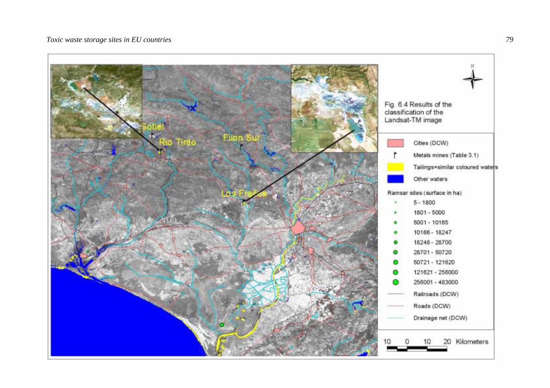
Toxic waste storage sites in EU countries 79