document19
TRANSCRIPT

HYDROTRAC
INSTALLATION / OPERATION MANUAL Version: 2.23
Odom Hydrographic Systems, Inc. 1450 Seaboard Avenue Baton Rouge, Louisiana
USA 70810-6261
Telephone: (225) 769-3051 Fax: (225) 766-5122
http://www.odomhydrographic.com
Number of pages: 59Date: June 14, 2007

Hydrotrac Installation / Operation Manual
Page 2 of 59
Odom Hydrographic Systems, Inc. June 14, 2007
Revision History Version Date Author Remarks
2.18 01-28-2003 Initial version – new template
2.20 09-20-2004 Added serial querying feature Added Appendix E: Frequency Agile Operation
2.22 02-17-2005 Stephen Apsey Added Remote Display instructions
2.23 06-14-2007 Patrick Oostenrijk Changed maximum bar depth to 100m, 300ft. Bugfix with
© ODOM HYDROGRAPHIC SYSTEMS, INC. 2007 All rights are reserved. Reproduction in whole or in part is prohibited without the prior written consent of the copy-right owner. The information presented in this document does not form part of any quotation or contract, is believed to beaccurate and reliable and may be subject to change without notice. The publisher will not accept any liability for any consequence of its use. Publication thereof does not convey nor imply any license under patent- or other industrial or intellectual property rights.
Hydrotrac Installation / Operation Manual
Page 3 of 59
Odom Hydrographic Systems, Inc. June 14, 2007
CONTENTS
1 Introduction...................................................................................................................................................... 5 1.1 Specifications .............................................................................................................................................. 5
1.1.1 Frequency ............................................................................................................................................ 5 1.1.2 Resolution ............................................................................................................................................ 5 1.1.3 Accuracy .............................................................................................................................................. 5 1.1.4 Output Power ....................................................................................................................................... 5 1.1.5 Power Requirement ............................................................................................................................. 5 1.1.6 Ports..................................................................................................................................................... 5 1.1.7 Features............................................................................................................................................... 5 1.1.8 Manual Controls................................................................................................................................... 6
1.2 Choice of Operating Frequencies ............................................................................................................... 6 1.3 Printer Mechanism ...................................................................................................................................... 6 1.4 Display......................................................................................................................................................... 6 1.5 Keypad ........................................................................................................................................................ 6 1.6 Receive ....................................................................................................................................................... 6 1.7 Transmit ...................................................................................................................................................... 7
2 Installation........................................................................................................................................................ 8 2.1 Introduction.................................................................................................................................................. 8 2.2 Cable Connections...................................................................................................................................... 9 2.3 Transducer Installation.............................................................................................................................. 11
2.3.1 THROUGH HULL............................................................................................................................... 11 2.3.2 SEA CHEST....................................................................................................................................... 12 2.3.3 Over-The-Side ................................................................................................................................... 13
2.4 Chart Paper............................................................................................................................................... 13 2.4.1 PAPER LOADING.............................................................................................................................. 14 2.4.2 Installing a fresh Paper Supply Roll................................................................................................... 15 2.4.3 Loading the Paper Take-Up Spool .................................................................................................... 15
3 Operation........................................................................................................................................................ 17 3.1 Introduction................................................................................................................................................ 17 3.2 Analog Controls......................................................................................................................................... 17
3.2.1 Power/TX Power ................................................................................................................................ 17 3.2.2 Sensitivity ........................................................................................................................................... 17
3.3 Parameter Controls ................................................................................................................................... 18 3.3.1 Changing Parameters ........................................................................................................................ 18
3.4 Display Screens ........................................................................................................................................ 19 3.4.1 Initial Power On Screen ..................................................................................................................... 19 3.4.2 System StartUp Menu........................................................................................................................ 19
3.4.2.1 Use Current Setup ...................................................................................................................... 19 3.4.2.2 Use Default Setup....................................................................................................................... 19 3.4.2.3 Maintenance Mode ..................................................................................................................... 20
3.5 Display Menus........................................................................................................................................... 21 3.5.1 Depth.................................................................................................................................................. 21 3.5.2 Setup.................................................................................................................................................. 21
3.5.2.1 Blanking ...................................................................................................................................... 22 3.5.2.2 Minimum Depth........................................................................................................................... 22 3.5.2.3 Range ......................................................................................................................................... 22 3.5.2.4 Com1 – Com2............................................................................................................................. 23 3.5.2.5 No Echo Alarm............................................................................................................................ 23 3.5.2.6 Time............................................................................................................................................ 24

Hydrotrac Installation / Operation Manual
Page 4 of 59
Odom Hydrographic Systems, Inc. June 14, 2007
3.5.2.7 Date ............................................................................................................................................ 24 3.5.2.8 External Triggering ..................................................................................................................... 24 3.5.2.9 Print Parameters......................................................................................................................... 24 3.5.2.10 Com1, Com2 Baud..................................................................................................................... 24 3.5.2.11 Language ................................................................................................................................... 24
3.5.3 Calibrate Menu................................................................................................................................... 24 3.5.3.1 Bar Depth.................................................................................................................................... 25 3.5.3.2 Draft & Index............................................................................................................................... 25 3.5.3.3 Velocity ....................................................................................................................................... 26 3.5.3.4 Simulator..................................................................................................................................... 26
3.5.4 Chart Menu ........................................................................................................................................ 26 3.5.4.1 Chart Center ............................................................................................................................... 26 3.5.4.2 Chart Width................................................................................................................................. 27 3.5.4.3 Chart Speed................................................................................................................................ 27 3.5.4.4 Phasing....................................................................................................................................... 27 3.5.4.5 Annotate ..................................................................................................................................... 27 3.5.4.6 Fix Interval/Start Number............................................................................................................ 27 3.5.4.7 Gauge ......................................................................................................................................... 27
3.6 Chart Controls ........................................................................................................................................... 28 3.6.1 ON/OFF.............................................................................................................................................. 28 3.6.2 FEED.................................................................................................................................................. 28 3.6.3 MARK................................................................................................................................................. 28
4 Interfacing ...................................................................................................................................................... 30 4.1 Computer Communications....................................................................................................................... 30
4.1.1 Serial Output Strings.......................................................................................................................... 30 4.1.1.1 Echotrac I/O................................................................................................................................ 30 4.1.1.2 Heave ......................................................................................................................................... 31 4.1.1.3 DESO 25..................................................................................................................................... 31 4.1.1.4 NMEA String (DBS) .................................................................................................................... 32
4.1.2 Serial Data Input and Annotation....................................................................................................... 32 4.1.2.1 Event Line (Fix Mark).................................................................................................................. 32 4.1.2.2 Event Annotation ........................................................................................................................ 33
4.1.3 EXTERNAL CONTROL OF UNIT PARAMETERS............................................................................ 33 4.1.3.1 INTRODUCTION ........................................................................................................................ 33 4.1.3.2 PROTOCOL................................................................................................................................ 34
4.2 Sensor Inputs ............................................................................................................................................ 36 4.2.1 GPS.................................................................................................................................................... 36 4.2.2 Heave Sensor .................................................................................................................................... 36
4.3 AUXILIARY Port........................................................................................................................................ 36 4.3.1 EXTERNAL TRIGGERING ................................................................................................................ 36
4.4 UPDATING FLASH MEMORY.................................................................................................................. 36 5 Calibration...................................................................................................................................................... 37
5.1 BAR CHECK CALIBRATION .................................................................................................................... 37 Appendix A. Using Hydrotrac with built in Starlink Invicta DGPS ................................................................... 40 Appendix B. Side Scan Operating Procedures: ................................................................................................. 45 Appendix C. Help Printouts .................................................................................................................................. 48 Appendix D. Hydrotrac Thermal Printhead Cleaning Procedure...................................................................... 53 Appendix E. Frequency Agile Hydrotrac Operation........................................................................................... 57 Appendix F. Remote Display Option ................................................................................................................... 59
Hydrotrac Installation / Operation Manual
Page 5 of 59
Odom Hydrographic Systems, Inc. June 14, 2007
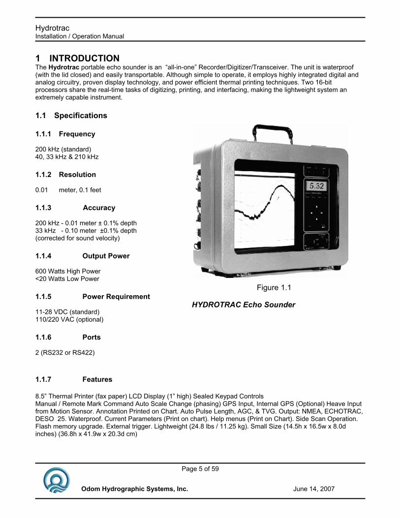
1 INTRODUCTION The Hydrotrac portable echo sounder is an “all-in-one” Recorder/Digitizer/Transceiver. The unit is waterproof (with the lid closed) and easily transportable. Although simple to operate, it employs highly integrated digital and analog circuitry, proven display technology, and power efficient thermal printing techniques. Two 16-bit processors share the real-time tasks of digitizing, printing, and interfacing, making the lightweight system an extremely capable instrument.
1.1 Specifications
1.1.1 Frequency 200 kHz (standard) 40, 33 kHz & 210 kHz
1.1.2 Resolution 0.01 meter, 0.1 feet
1.1.3 Accuracy 200 kHz - 0.01 meter ± 0.1% depth 33 kHz - 0.10 meter ±0.1% depth (corrected for sound velocity)
1.1.4 Output Power 600 Watts High Power <20 Watts Low Power
1.1.5 Power Requirement 11-28 VDC (standard) 110/220 VAC (optional)
1.1.6 Ports 2 (RS232 or RS422)
1.1.7 Features 8.5” Thermal Printer (fax paper) LCD Display (1” high) Sealed Keypad Controls Manual / Remote Mark Command Auto Scale Change (phasing) GPS Input, Internal GPS (Optional) Heave Input from Motion Sensor. Annotation Printed on Chart. Auto Pulse Length, AGC, & TVG. Output: NMEA, ECHOTRAC, DESO 25. Waterproof. Current Parameters (Print on chart). Help menus (Print on Chart). Side Scan Operation. Flash memory upgrade. External trigger. Lightweight (24.8 lbs / 11.25 kg). Small Size (14.5h x 16.5w x 8.0d inches) (36.8h x 41.9w x 20.3d cm)
Figure 1.1
HYDROTRAC Echo Sounder

Hydrotrac Installation / Operation Manual
Page 6 of 59
Odom Hydrographic Systems, Inc. June 14, 2007
1.1.8 Manual Controls Sensitivity Power OFF, STANDBY, TX Power, LOW, MED, HIGH. Chart ON/OFF. Chart Feed. Chart Mark
1.2 Choice of Operating Frequencies The single frequency Hydrotrac currently offers the user a choice of one of four frequencies: Low (40kHz and 33kHz), High (200kHz and 210kHz). Standard transducers are generally available from stock in all of the above frequencies with an assortment of beam patterns to choose from. A 200 kHz Side Scan transducer is also available.
1.3 Printer Mechanism The high-resolution thin-film thermal print head (216mm (8.5”) wide, 8 dots per mm (203/in.)) is capable of printing up to 8 gray shades on high quality thermal film. Due to its thin-film construction, it is very energy efficient and produces little excess heat. The paper delivery and re-winding mechanisms contain few moving parts and are built to stand up to the rigors of marine use.
1.4 Display The 4 line, by 20 character Transflective LCD Module with LED Back Lighting was chosen for it’s excellent visibility in all light conditions from bright sun to darkened wheel house.
1.5 Keypad The 10 raised micro-switches are part of the sealed display panel (Figure 1.2). The keys have excellent tactile feel and high moisture resistance. The keypad is used by the operator for direct parameter entry and functional control of the unit from the front panel.
1.6 Receive The system incorporates both TVG (Time Varied Gain) and operator adjusted Sensitivity. Sensitivity is continuously variable by a front panel mounted potentiometer, while TVG is set internally in software.
Figure 1.2
Control Panel

Hydrotrac Installation / Operation Manual
Page 7 of 59
Odom Hydrographic Systems, Inc. June 14, 2007
1.7 Transmit Transmit frequencies are digitally synthesized and based on the stable frequency characteristics of a crystal controlled clock oscillator. Transmitted power is adjustable via a front panel mounted control (Low, Medium, and High) while the transmit pulse length is varied automatically depending on frequency.

Hydrotrac Installation / Operation Manual
Page 8 of 59
Odom Hydrographic Systems, Inc. June 14, 2007
2 INSTALLATION This section contains the information necessary to power and interconnect the Hydrotrac portable echo sounder as part of an integrated hydrographic data acquisition system. Included also is a brief description of three methods of mounting an associated transducer.
2.1 Introduction The Recorder is a freestanding unit designed for tabletop, rack or bulkhead mounting. Rack or bulkhead mounting can be accommodated with the addition of special hardware. Where tabletop mounting is preferred, it is recommended that the unit be secured for rough seas or heavy swells. An interconnection diagram is shown in Figure 2.1 and cable details are given in Section 2.3. Care should be taken to route cables using horizontal and vertical runs wherever possible. Avoid paths that run adjacent to transmitter feeder cables or close to heat radiating elements such as steam pipes. For permanent installations, cables should be clamped at regular intervals (1m) along their complete lengths. Hydrotrac is available in a choice of input voltages: +11 to +28 VDC (standard), or 110/220 VAC (optional at extra cost). The unit consumes less than 30 watts of power in normal operation. Power is frequently derived from one or two 12 V lead-acid car batteries. Two “car” batteries (24V configuration), fully charged, and in good condition, can normally power a unit for a full day without re-charging. If the internal AC supply is used, the circuit should be monitored closely for voltage transients, spikes, and mains induced noise. Details of the power cable are given in Section 2-3. Should the input voltage polarity be applied in reverse, an audible alarm within the unit will sound regardless of the POWER switch setting. The first indication of a low voltage condition is usually a faded chart record.
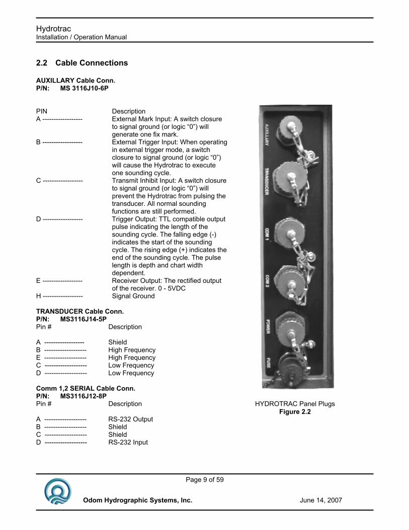
All cabling is via the connectors located in the recessed compartment at the left rear of the unit (Figure 2.2). Connections are made via multi-pin “MS” style connectors, between the Hydrotrac, its power source, the transducer and all computer or peripheral devices.
Figure 2.1Interconnection Block Diagram
COMPUTER
Motion Sensor
GPSReceiver
Power Transducer
CommComm
HYDROTRACEcho Sounder
External Trigger *
* In External Trigger Mode
Hydrotrac Installation / Operation Manual
Page 9 of 59
Odom Hydrographic Systems, Inc. June 14, 2007
2.2 Cable Connections AUXILLARY Cable Conn. P/N: MS 3116J10-6P PIN Description A ------------------ External Mark Input: A switch closure
to signal ground (or logic “0”) will generate one fix mark.
B ------------------ External Trigger Input: When operating in external trigger mode, a switch closure to signal ground (or logic “0”) will cause the Hydrotrac to execute one sounding cycle.
C ------------------ Transmit Inhibit Input: A switch closure to signal ground (or logic “0”) will prevent the Hydrotrac from pulsing the transducer. All normal sounding functions are still performed.
D ------------------ Trigger Output: TTL compatible output pulse indicating the length of the sounding cycle. The falling edge (-) indicates the start of the sounding cycle. The rising edge (+) indicates the end of the sounding cycle. The pulse length is depth and chart width dependent.
E ------------------ Receiver Output: The rectified output of the receiver. 0 - 5VDC
H ------------------ Signal Ground TRANSDUCER Cable Conn. P/N: MS3116J14-5P Pin # Description A ------------------ Shield B ------------------- High Frequency E ------------------- High Frequency C ------------------- Low Frequency D ------------------- Low Frequency Comm 1,2 SERIAL Cable Conn. P/N: MS3116J12-8P Pin # Description A ------------------- RS-232 Output B ------------------- Shield C ------------------- Shield D ------------------- RS-232 Input
HYDROTRAC Panel PlugsFigure 2.2

Hydrotrac Installation / Operation Manual
Page 10 of 59
Odom Hydrographic Systems, Inc. June 14, 2007
Remote Display Option Comm 2 SERIAL Cable Conn. P/N: MS3116J12-8P Pin # Description A ------------------- RS-422 Output B B ------------------- Shield C ------------------- Shield D ------------------- RS-422 Input B E ------------------- RS-422 Input A F ------------------- +24 VDC H ------------------- RS-422 Output A POWER Cable Conn. (DC only) P/N: MS3116J12-3S Pin # Description A -------------------- +12 or 24 VDC B -------------------- No Connection C -------------------- Return Fuse 5 amp (DC inputs only) Standard Transducer Wiring Transducer Model #
Description
Pin Connections
SM200-10 200kHz 10o A - Shield B – Signal (Black) E – Signal (White) SM200-2.75 200kHz 2.75o A – Shield B – Signal (Black) E – Signal (White) TM33-20 33kHz 20° A – Shield C – Signal (Black) D – Signal (White) HM40-20 A – Shield C – Signal (Black) D – Signal (White)

Hydrotrac Installation / Operation Manual
Page 11 of 59
Odom Hydrographic Systems, Inc. June 14, 2007
2.3 Transducer Installation Proper mounting of the transducer is a crucial part of the installation of any “survey” echo sounder. An improperly mounted transducer will result in poor system operation and unacceptable data quality. In the case of temporary installations, the transducer is often mounted over-the-side. In permanent installations and “pay surveys,” hull mounts are generally preferred and often required. In either case, the transducer should be mounted as far below the waterline as possible. In cases where “over the side” mounts are exposed to wave action, ensure that the transducer is mounted far enough below the surface so that it remains well submerged during vessel roll motions. A preferred mounting location is near the keel of the vessel, in an area where the planing attitude of the hull, and the pitch and roll angles of the vessel, have the least effect at operating speed. The transducer should be mounted far enough aft of the bow so that bubbles generated by the bow wave will not pass over the face of the unit. Transducers should be located away from sources of turbulence and cavitation bubbles such as propellers, bow thrusters and hull protrusions. Consideration should also be given to sources of mechanical noise generated within the vessel (engines, propellers, pumps, generators, etc.). In some severe cases of mechanically coupled noise, vibration-isolating mounts may be required to mechanically decouple the transducer from the hull. Transducer mounting can be accomplished in many different ways. To follow is a list of common configurations:
2.3.1 THROUGH HULL The top side of the transducer is accessible from inside the vessel while the transducer face is directly exposed to the water. Care should be taken to protect the transducer from damage and turbulence by installing a faring with a sloping forward edge ahead of the unit (Figure 2.3). The faring has the dual effect of both minimizing possible strike damage and smoothing the flow of water over the face of the transducer.

Hydrotrac Installation / Operation Manual
Page 12 of 59
Odom Hydrographic Systems, Inc. June 14, 2007
2.3.2 SEA CHEST In a “sea chest” mount, a fluid-filled enclosure, large enough to contain the entire transducer is attached to the outer hull of the vessel. The outer hull is removed within the area of the chest and replaced with an acoustically clear “window”, which is mounted flush with the hull surrounding the chest. Depending on construction, the material selected for the acoustic window, and the draft of the vessel, access can often be gained to the transducer from inside the hull without putting the vessel in dry-dock. In most installations, a water filled standpipe is incorporated into the “sea chest” design in order to provide hydrostatic pressure equalization. Transducer cables generally leave these assemblies through stuffing tubes, which maintain the watertight integrity of the chest.

Hydrotrac Installation / Operation Manual
Page 13 of 59
Odom Hydrographic Systems, Inc. June 14, 2007
2.3.3 Over-The-Side A mount of this type is frequently constructed from a length of pipe. This fixture should be sized to position the transducer well below the waterline and the pipe then fixed to a sturdy support on the vessel. Lines generally are attached at the transducer pipe and tied off fore and aft in order to maintain a stable, horizontal transducer attitude. Care should be taken to assure adequate protection for the transducer cable, particularly at the point where the cable leaves the transducer body.
In all of the above installations, particular care should be taken to assure that the transducer radiating face remains as nearly parallel to the water surface as possible while the vessel is underway.
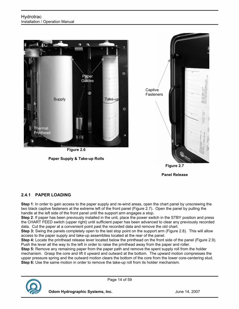
2.4 Chart Paper General Paper Description: The Hydrotrac uses either thermal film or high quality thermal paper as the recording medium for the analog chart. The rolls are 216mm (8.5”) wide and contain approximately 50m (170’) of paper or film. The inside diameter of the core is 12.7mm (½”); the outside diameter of the roll is approximately 64mm (2.5”). Paper loading is a multi-step process, but it need not be a difficult one if care is taken in assuring that each step is accomplished properly. As in almost any thermal recorder (including FAX machines), paper is sourced from a supply roll, where it passes between alignment posts, and over a rubber roller fig 2.6, which moves the paper past the thermal printhead. Attached to the printhead is a mechanical pressure lever, which when moved to the left, lifts the head away from the roller to assist in the initial loading. In the Hydrotrac, printed chart paper is taken-up on an empty core installed at the far left of the chart panel. A precision stepper motor attached to the printhead assembly drive roller pulls paper off the supply roll and moves it past the printhead. The motor that drives the take-up spool does not advance the paper, as is the case in many echo sounders. Since paper drive and take-up are driven by separate mechanisms, previously printed chart can be pulled from the take-up assembly for review and simply re-wound without disturbing the recording process.
Figure 2.5
Over-The-Side Mount
Hydrotrac Installation / Operation Manual
Page 14 of 59
Odom Hydrographic Systems, Inc. June 14, 2007
Figure 2.7
Panel Release
Captive Fasteners
Figure 2.6
Paper Supply & Take-up Rolls
Supply Take-up
Thermal Printhead
Paper Guides
2.4.1 PAPER LOADING Step 1: In order to gain access to the paper supply and re-wind areas, open the chart panel by unscrewing the two black captive fasteners at the extreme left of the front panel (Figure 2.7). Open the panel by pulling the handle at the left side of the front panel until the support arm engages a stop. Step 2: If paper has been previously installed in the unit, place the power switch in the STBY position and press the CHART FEED switch (upper right) until sufficient paper has been advanced to clear any previously recorded data. Cut the paper at a convenient point past the recorded data and remove the old chart. Step 3: Swing the panels completely open to the last stop point on the support arm (Figure 2.8). This will allow access to the paper supply and take-up assemblies located at the rear of the panel. Step 4: Locate the printhead release lever located below the printhead on the front side of the panel (Figure 2.9). Push the lever all the way to the left in order to raise the printhead away from the paper and roller. Step 5: Remove any remaining paper from the paper path and remove the spent supply roll from the holder mechanism. Grasp the core and lift it upward and outward at the bottom. The upward motion compresses the upper pressure spring and the outward motion clears the bottom of the core from the lower core-centering stud. Step 6: Use the same motion in order to remove the take-up roll from its holder mechanism.

Hydrotrac Installation / Operation Manual
Page 15 of 59
Odom Hydrographic Systems, Inc. June 14, 2007
Figure 2.9
Printhead Release Lever
release
2.4.2 Installing a fresh Paper Supply Roll Step 1: On the paper supply side (side closest to the printhead), raise the upper paper guide until the spring is fully compressed. Step 2:Insert the fresh roll of paper so that the core engages the top paper-centering stud and so that the paper comes off the roll at the rear (as viewed from the front panel side of the unit) and the outside surface of the paper faces the printhead. Step 3: Align the roll so that it engages the lower centering stud, as it is set onto the lower paper guide. Feeding Paper past the Printhead Step 4: Feed paper off the supply roll from the rear and over the paper drive roller (between the printhead and the roller) with the outside surface of the roll toward the printhead. Only the outside surface of the paper will produce an image. Note: the printhead release lever must be in the released position (far left position) in order to accomplish this task. Step 5: Once a small amount of paper is fed across the roller past the printhead, pull approximately 450mm (18”) through the printer. This can be done easily if the paper is not allowed to engage the rubber paper drive roller with too much tension. Feeding paper manually off the supply roll while pulling it past the printhead will assist in this task. Once sufficient paper is fed past the print head, center the paper manually and return the printhead release lever to the engaged position (head locked down on the paper supply roller).
2.4.3 Loading the Paper Take-Up Spool Step1: Guide the end of the paper through the paper entry slot and over the take-up roller bar. Pull the excess paper through the slot. Step 2: Using a small piece of tape, attach the end of the paper to an empty paper core being sure to align the top and bottom edges of the paper with the ends of the core. Wind the extra paper up tightly onto the core. Note: As shipped from the factory, paper is re-wound on the spent core in the same direction as it is fed off the paper supply roll. This means that the printed image is wound on the outside surface of the recorded roll. Please note! Best results are derived when a new core is installed on the Take-up spool with each new roll of paper. Repeated use of the same Take-up core will result in the unit’s failing to re-wind paper reliably.
Figure 2.8 Front Panel Extended
Hydrotrac Installation / Operation Manual
Page 16 of 59
Odom Hydrographic Systems, Inc. June 14, 2007
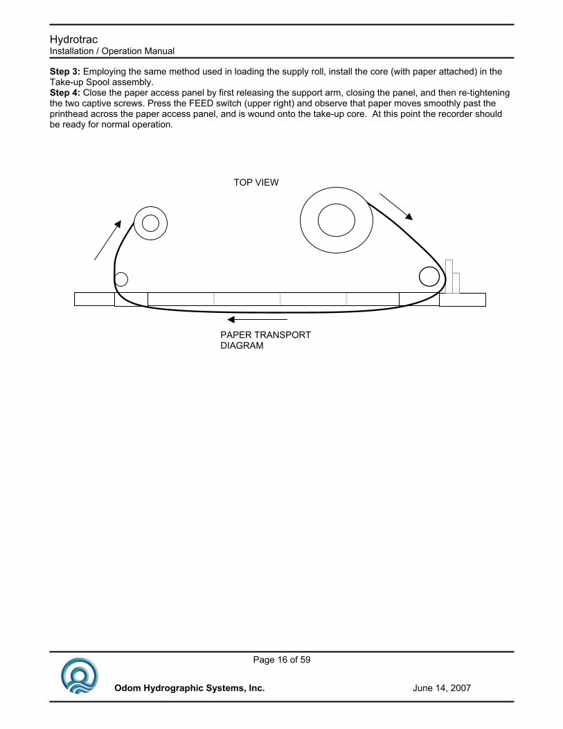
Step 3: Employing the same method used in loading the supply roll, install the core (with paper attached) in the Take-up Spool assembly. Step 4: Close the paper access panel by first releasing the support arm, closing the panel, and then re-tightening the two captive screws. Press the FEED switch (upper right) and observe that paper moves smoothly past the printhead across the paper access panel, and is wound onto the take-up core. At this point the recorder should be ready for normal operation.
PAPER TRANSPORT DIAGRAM
TOP VIEW
Hydrotrac Installation / Operation Manual
Page 17 of 59
Odom Hydrographic Systems, Inc. June 14, 2007
3 OPERATION
3.1 Introduction This section contains the information necessary to operate the Hydrotrac unit using the Analog controls, the Parameter entry keypad, and the Printer controls.
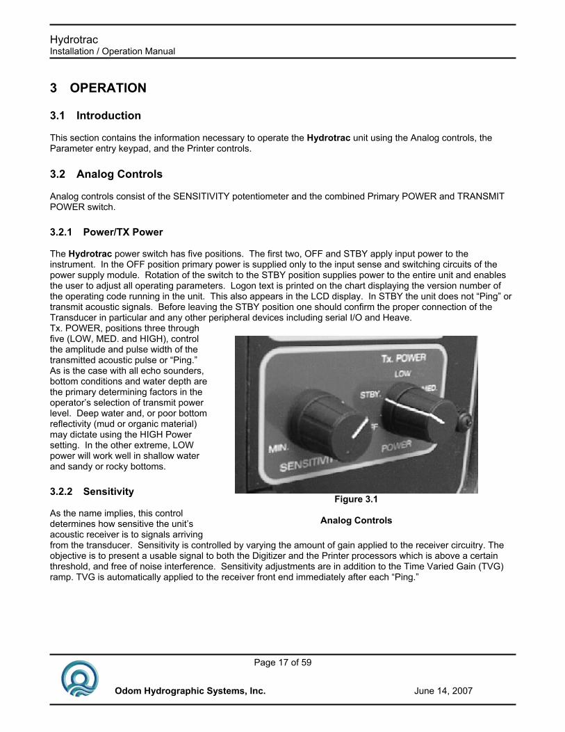
3.2 Analog Controls Analog controls consist of the SENSITIVITY potentiometer and the combined Primary POWER and TRANSMIT POWER switch.
3.2.1 Power/TX Power The Hydrotrac power switch has five positions. The first two, OFF and STBY apply input power to the instrument. In the OFF position primary power is supplied only to the input sense and switching circuits of the power supply module. Rotation of the switch to the STBY position supplies power to the entire unit and enables the user to adjust all operating parameters. Logon text is printed on the chart displaying the version number of the operating code running in the unit. This also appears in the LCD display. In STBY the unit does not “Ping” or transmit acoustic signals. Before leaving the STBY position one should confirm the proper connection of the Transducer in particular and any other peripheral devices including serial I/O and Heave. Tx. POWER, positions three through five (LOW, MED. and HIGH), control the amplitude and pulse width of the transmitted acoustic pulse or “Ping.” As is the case with all echo sounders, bottom conditions and water depth are the primary determining factors in the operator’s selection of transmit power level. Deep water and, or poor bottom reflectivity (mud or organic material) may dictate using the HIGH Power setting. In the other extreme, LOW power will work well in shallow water and sandy or rocky bottoms.
3.2.2 Sensitivity As the name implies, this control determines how sensitive the unit’s acoustic receiver is to signals arriving from the transducer. Sensitivity is controlled by varying the amount of gain applied to the receiver circuitry. The objective is to present a usable signal to both the Digitizer and the Printer processors which is above a certain threshold, and free of noise interference. Sensitivity adjustments are in addition to the Time Varied Gain (TVG) ramp. TVG is automatically applied to the receiver front end immediately after each “Ping.”
Figure 3.1
Analog Controls

Hydrotrac Installation / Operation Manual
Page 18 of 59
Odom Hydrographic Systems, Inc. June 14, 2007
Figure 3.2 Parameter Setting
3.3 Parameter Controls In the Hydrotrac, parameters which control the way the echo sounder works—digitizing, printing, or communicating to the outside world, are manipulated using a system of menus and front panel mounted sealed keys. The display is a four line by twenty-character alpha numeric, transflective LCD module. The display is backlighted for nighttime viewing by yellow LED’s. The keys are made up of 10 embossed micro-switches molded into the display panel overlay. Each key is labeled with its function and provides positive tactile feedback upon actuation. The four keys located directly below the display provide immediate access to the four main menus for which they are labeled (DEPTH, SETUP, CHART, CAL.). The UP, DOWN, LEFT, and RIGHT arrow keys are used to navigate through the individual parameters and to change their associated values. The ENTER key is used to select a parameter who’s value is to be changed. Pressing the HELP key provides the operator with an immediate printed explanation of the purpose and use of the selected parameter.
3.3.1 Changing Parameters The method used to change any parameter value is common to all parameters in the system. To follow is a description and typical example of the procedure: For instance, should we wish to change the internal time of day clock: First press the Setup Key, to access to the menu containing the Time parameter. Second, Select the Time parameter by moving the arrows (using the UP and Down arrow keys) to the Time line and then pressing Enter. Once the value for Time is selected (the blinking block cursor appears behind one of the digits), use the LEFT or RIGHT arrow keys to choose Hours, Minutes, or Seconds by moving the Cursor to the appropriate digit. Using the UP or DOWN arrow keys, slew in the new value. If necessary, move the cursor to the next digit (using the LEFT and RIGHT arrow keys again) and slew the correct digit into place. Once the displayed Time parameter is correct, press Enter again. This will cause the new value to become the current time. This method of entering data is common to all parameters.
Hydrotrac Installation / Operation Manual
Page 19 of 59
Odom Hydrographic Systems, Inc. June 14, 2007
3.4 Display Screens
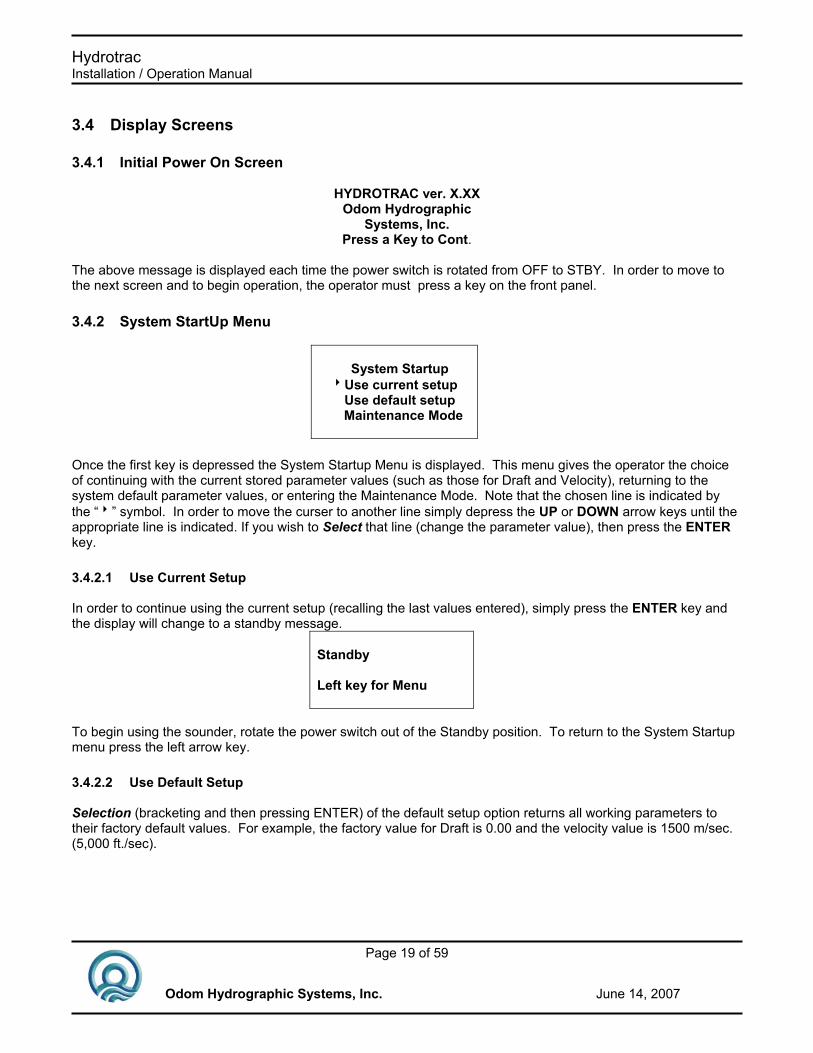
3.4.1 Initial Power On Screen
HYDROTRAC ver. X.XX Odom Hydrographic
Systems, Inc. Press a Key to Cont.
The above message is displayed each time the power switch is rotated from OFF to STBY. In order to move to the next screen and to begin operation, the operator must press a key on the front panel.
3.4.2 System StartUp Menu
System Startup 8Use current setup Use default setup
Maintenance Mode
Once the first key is depressed the System Startup Menu is displayed. This menu gives the operator the choice of continuing with the current stored parameter values (such as those for Draft and Velocity), returning to the system default parameter values, or entering the Maintenance Mode. Note that the chosen line is indicated by the “8” symbol. In order to move the curser to another line simply depress the UP or DOWN arrow keys until the appropriate line is indicated. If you wish to Select that line (change the parameter value), then press the ENTER key.
3.4.2.1 Use Current Setup In order to continue using the current setup (recalling the last values entered), simply press the ENTER key and the display will change to a standby message.
Standby Left key for Menu
To begin using the sounder, rotate the power switch out of the Standby position. To return to the System Startup menu press the left arrow key.
3.4.2.2 Use Default Setup Selection (bracketing and then pressing ENTER) of the default setup option returns all working parameters to their factory default values. For example, the factory value for Draft is 0.00 and the velocity value is 1500 m/sec. (5,000 ft./sec).
Hydrotrac Installation / Operation Manual
Page 20 of 59
Odom Hydrographic Systems, Inc. June 14, 2007
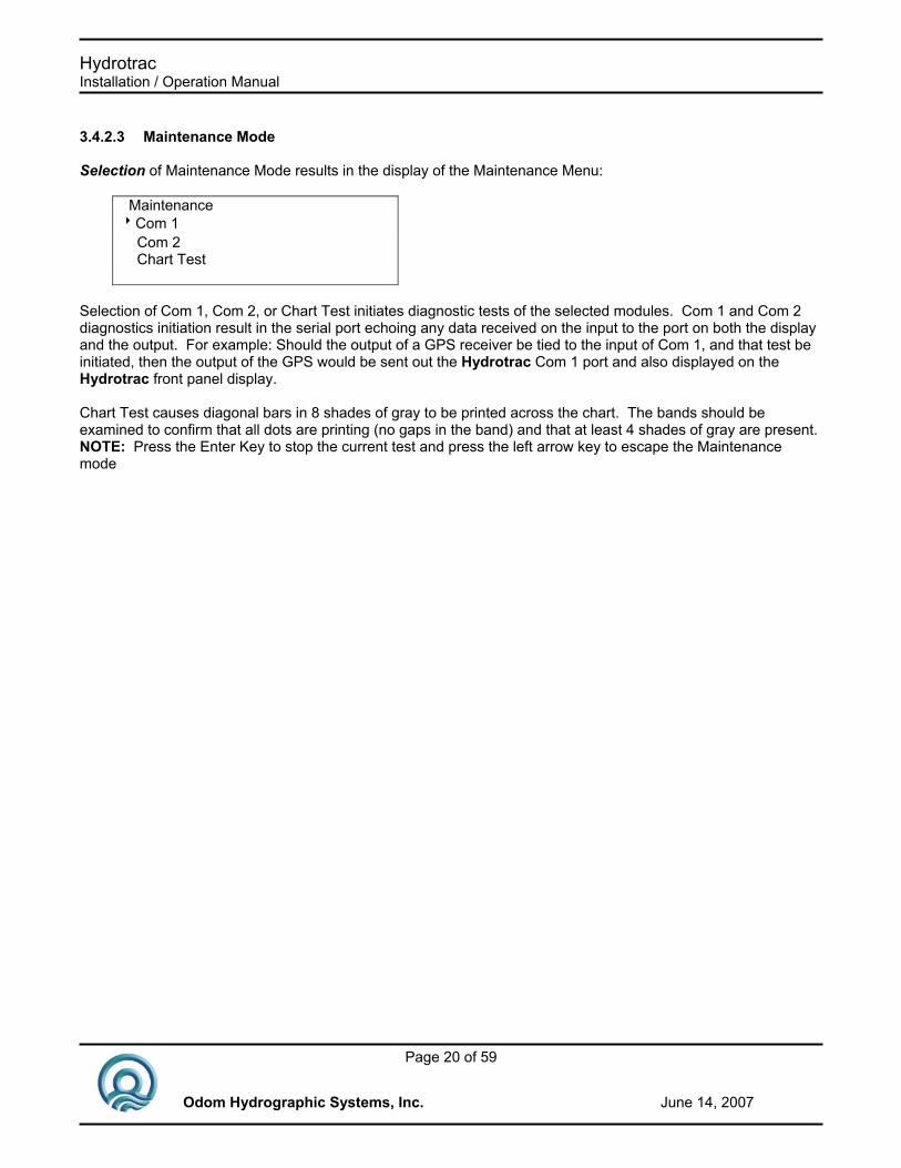
3.4.2.3 Maintenance Mode Selection of Maintenance Mode results in the display of the Maintenance Menu:
Maintenance 8Com 1 Com 2 Chart Test
Selection of Com 1, Com 2, or Chart Test initiates diagnostic tests of the selected modules. Com 1 and Com 2 diagnostics initiation result in the serial port echoing any data received on the input to the port on both the display and the output. For example: Should the output of a GPS receiver be tied to the input of Com 1, and that test be initiated, then the output of the GPS would be sent out the Hydrotrac Com 1 port and also displayed on the Hydrotrac front panel display. Chart Test causes diagonal bars in 8 shades of gray to be printed across the chart. The bands should be examined to confirm that all dots are printing (no gaps in the band) and that at least 4 shades of gray are present. NOTE: Press the Enter Key to stop the current test and press the left arrow key to escape the Maintenance mode

Hydrotrac Installation / Operation Manual
Page 21 of 59
Odom Hydrographic Systems, Inc. June 14, 2007
3.5 Display Menus
3.5.1 Depth Pressing the DEPTH key on the front panel results in immediate display of the digitized depth. The large characters incorporate segments from all four lines of the display. This is done in order to achieve the size needed for distant viewing. While DEPTH is the Menu most often displayed, it is not necessary to select the DEPTH menu in order for the unit to operate normally. The Hydrotrac continues to sound, digitize and display the depth (in the upper right corner of the display) in all of the menus except Maintenance. When a GPS receiver is installed in the Hydrotrac, or GPS data is input to the unit, latitude and longitude can be displayed alternatively with the Depth display. Access to the latitude and longitude display is gained by pressing the DEPTH key (toggles between the large depth display and the latitude and longitude at each activation).
3.5.2 Setup Pressing the SETUP key initiates the display of the basic parameters of the unit, which include the following:
Setup 10.01 8Blanking 0.0 Min. Depth 0 ↓Units Meters Range 100 Com1 Echotrac I/O
Nmea GLL IN Nmea GGA IN Nmea DBS Out DESO 25 I/O ETMark1 Heave Out
Com2 OFF NemaGLL IN Nmea GGA IN Heave IN Remote Disp
No Echo Alarm ON/OFF Time 15:32:15 Date 10/20/97 Ext Trigger ON/OFF Print Parameters Com1 Baud 19200, 9600, 4800 Com2 Baud 19200, 9600, 4800 Language English/Spanish
English/German
Hydrotrac Installation / Operation Manual
Page 22 of 59
Odom Hydrographic Systems, Inc. June 14, 2007
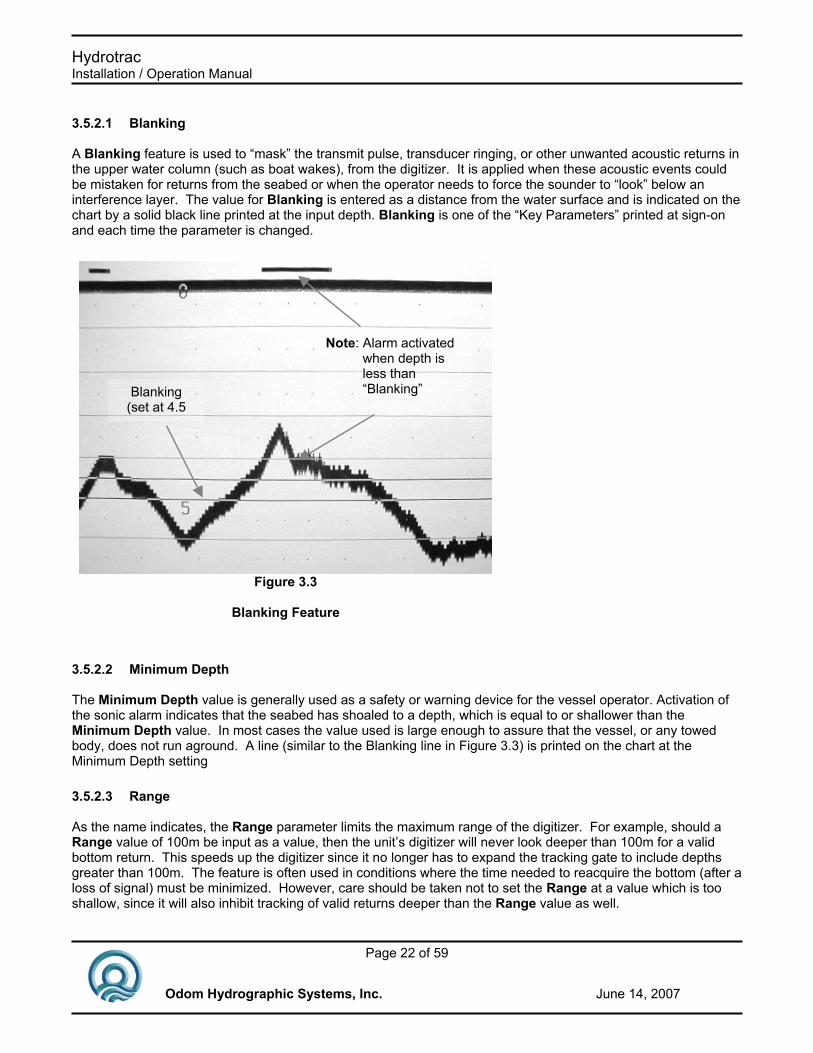
3.5.2.1 Blanking A Blanking feature is used to “mask” the transmit pulse, transducer ringing, or other unwanted acoustic returns in the upper water column (such as boat wakes), from the digitizer. It is applied when these acoustic events could be mistaken for returns from the seabed or when the operator needs to force the sounder to “look” below an interference layer. The value for Blanking is entered as a distance from the water surface and is indicated on the chart by a solid black line printed at the input depth. Blanking is one of the “Key Parameters” printed at sign-on and each time the parameter is changed.
3.5.2.2 Minimum Depth The Minimum Depth value is generally used as a safety or warning device for the vessel operator. Activation of the sonic alarm indicates that the seabed has shoaled to a depth, which is equal to or shallower than the Minimum Depth value. In most cases the value used is large enough to assure that the vessel, or any towed body, does not run aground. A line (similar to the Blanking line in Figure 3.3) is printed on the chart at the Minimum Depth setting
3.5.2.3 Range As the name indicates, the Range parameter limits the maximum range of the digitizer. For example, should a Range value of 100m be input as a value, then the unit’s digitizer will never look deeper than 100m for a valid bottom return. This speeds up the digitizer since it no longer has to expand the tracking gate to include depths greater than 100m. The feature is often used in conditions where the time needed to reacquire the bottom (after a loss of signal) must be minimized. However, care should be taken not to set the Range at a value which is too shallow, since it will also inhibit tracking of valid returns deeper than the Range value as well.
Figure 3.3
Blanking Feature
Blanking (set at 4.5
)
Note: Alarm activated when depth is less than “Blanking”

Hydrotrac Installation / Operation Manual
Page 23 of 59
Odom Hydrographic Systems, Inc. June 14, 2007
3.5.2.4 Com1 – Com2 Two bi-directional RS-232 (or RS-422) communication ports can be configured to provide maximum flexibility in both transmitting and logging data. In most applications, Com1 will be configured to transmit the most recent depth at the end of each sounding cycle to a data logger (PC or other device). In many cases, a motion compensating device will be required to be incorporated in the survey in order to remove the Heave motion from the digital record. In this situation, the Heave compensator should be connected to Com2, and that port configured for Heave In. In order to accomplish this task the following steps are required: 1) Using the arrow keys, move the brackets to the Com1 line and press the ENTER key. 2) Press the arrow keys until the proper string is displayed, in this case Echotrac I/O, and then press the ENTER key. 3) Press the arrow keys again to bracket the Com2 line. Press ENTER to select Com2. 4) Press the arrow keys again until Heave In is displayed. 5) Press ENTER again. This procedure will put the sounder into the Heave compensation mode, wherein both displayed and transmitted depth data are corrected for the vessel’s vertical motion. A second Heave configuration has been incorporated at the factory in Hydrotrac units with serial numbers 10294 and higher. Under the Com1 parameter a new option is available entitled Heave Out. Selection of this parameter causes the sounder to output uncorrected depths with the appropriate heave value added to the string. The raw heave line and corrected seabed are printed on the chart and the digital display continues to be corrected for vertical motion. In some very portable applications, the operator may need to use the Hydrotrac as a data-concatenating device. In this scenario, Com1 remains configured for data output while Com2 is reconfigured to read position from a GPS receiver (NMEA GLL or GGA string only). Proceed as follows: Under the Com1 parameter, select the Nmea DBS out string. Go to Com2 and select Nmea GLL IN or Nmea GGA IN. Once soundings have begun and the GLL or GGA position string is applied to Com2, both depth and position will be combined into one string and output through COM1.
3.5.2.5 No Echo Alarm Sounds audible alarm when the Digitizer fails to acquire a valid depth during the sounding cycle.
COMPUTER
GPS RECEIVER
HYDROTRACEcho Sounder
Power Transducer
Com1
Com2
Figure 3.4 Standalone configuration

Hydrotrac Installation / Operation Manual
Page 24 of 59
Odom Hydrographic Systems, Inc. June 14, 2007
3.5.2.6 Time An internal real-time clock is used for time and date information even when power is removed from the unit. The correct time of day (or reference time) is entered via this parameter. First Time is made the current selection by moving the brackets to the Time line and then pressing Enter. Once the value for time is selected, use the LEFT or RIGHT arrow keys to chose the appropriate Hour, Minute, or Second digit. The selected digit will be noted by the presence of the blinking Block Cursor. Use the UP or DOWN arrow keys to slew to a new value. Pressing Enter again will cause the new value to become the current time.
3.5.2.7 Date The current Date is entered in much the same manner as Time. Begin by selecting the proper line and then choose the digit to be changed. Use the UP or DOWN arrow keys to slew to a new value. Pressing Enter again will cause the new value to become the current Date.
3.5.2.8 External Triggering When the External trigger mode is set to ON, the individual sounding cycles can be controlled through the Auxiliary port. In this operating mode a falling edge (TTL pulse) on the Trigger input of the Auxiliary port begins the sounding cycle. At the end of the cycle, a digital depth is generated and output from the Com 1 port. This sequence of events ends the cycle and another sounding will not be initiated until a subsequent falling edge is detected or the sounder is taken out of the External Trigger Mode.
3.5.2.9 Print Parameters Prints all the system parameters on the chart. Unit must be in STANDBY.
3.5.2.10 Com1, Com2 Baud Set the baud rate for com 1 and com 2 from 4800 baud to 19,200 baud.
3.5.2.11 Language Selects the menu language of the echo sounder. Firmware supports either English/Spanish or English/German.
3.5.3 Calibrate Menu Pressing the CAL. key initiates the display of the parameters required to accomplish a standard “Bar Check” calibration procedure. Included are the following:
Calibrate 10.01 Bar Depth 10 Draft 1.6 Index .7 Velocity 1500 Simulator On/Off
Please note that the current depth is displayed in the upper right hand corner of all of the menus as long as the Hydrotrac is actively sounding. In the Cal menu, it is provided in order to allow the operator to immediately see the effect of changing either Draft or Velocity. It also makes it easy to confirm that the digitizer is locked either on the “Check Bar”, during the calibration process, or on the bottom when no value for Bar Depth is selected. The digitizer gate limits are also printed on the chart.

Hydrotrac Installation / Operation Manual
Page 25 of 59
Odom Hydrographic Systems, Inc. June 14, 2007
3.5.3.1 Bar Depth Entering a value other than “0” in the Bar Depth parameter puts the Hydrotrac in the “Bar Check Calibration Mode”. If, for example, the operator enters a value of 5.00m as the Bar Depth parameter, then immediately upon pressing enter, the Digitizer will expect to see a target at that 5.00 meter depth (± 0.5m) while rejecting all other returns (including those from the bottom). At the same time, the printer will begin to print the tracking gate at a total width of 1.00m centered about the Bar Depth.
3.5.3.2 Draft & Index Draft is the correction value added to the measured depth to adjust for the difference between the depth of the transducer and the water’s surface (a + dr – k) where: “a” is the measured depth and “dr” equals the draft (depth of the transducer below the water surface). Index constant “k” is system delays originating in both transducer and echo sounder circuitry. In the accompanying illustration, “d” is equal to the depth of the seabed below the water’s surface. Note: Many users may not be familiar with the parameter “Index” or “k”, although it is likely that they have seen the results of combining transducer draft and index constant into one draft figure. If you have noticed that the measured draft, or the distance from the face of the transducer to the water’s surface is not the same as the draft value entered into the sounder, then you have seen the result of lumping both together. This phenomenon is most evident when using dual frequency transducers where both high and low elements are in the same housing. Often, the draft values are very different for the two frequencies if no adjustable “k” parameter is incorporated. The difference in “k” or electronic delay between a 200 kHz element and a 24 kHz array is substantial, and is the reason behind the difference between the two “Calculated Drafts”. Once the “k” value is determined, it will not change until either the sounder or the transducer is changed. The Index parameter should be adjusted to make the measured draft and the calculated draft equal. Depth is computed according to the General Formula shown below:
d = ½ (v * t) - k + dr
Figure 3.5 Bar Check Calibration
Hydrotrac Installation / Operation Manual
Page 26 of 59
Odom Hydrographic Systems, Inc. June 14, 2007
d = depth from water’s surface v = average speed of sound in the water column t = measured elapsed time of signal travel from transducer to seabed and back to the transducer k = system index constant dr= difference from referenced water surface to transducer (draft)
3.5.3.3 Velocity This parameter allows the operator to change the speed of sound variable in the depth equation. Having the ability to change the speed of sound increases the accuracy of the system by allowing the sounder to adapt to changing local conditions that affect the propagation speed of sound in the water. Whether derived as a result of the “Bar Check” method of calibration, or taken directly from a velocimeter, Velocity is critical to measurement accuracy.
3.5.3.4 Simulator The Simulator feature of the Hydrotrac allows the user to exercise or demonstrate the features of the sounder without the restraint of having a transducer or transducer simulator connected to the unit. This feature initiates printing of a simulated return on the chart. The depth of the simulated return is varied by changing the position of the Sensitivity knob. To initiate the Simulator Mode, place the sounder in STBY and select the Cal Menu. Decrement the parameter list until Simulator is bracketed (>Simulator OFF<). Press the Enter key to Select the parameter and press the up or down arrow keys until ON is displayed as the value. Press Enter again and switch Power to LOW. Printing of a simulated bottom will begin. All other functions of the sounder, including digitization and parameter controls, will now function normally. NOTE: After using the Simulator feature, be sure to turn the Simulator Mode OFF before powering the sounder down. Since all parameter values are stored in Nonvolatile memory, then once the unit is turned ON again the simulator mode will remain active if it has not been turned OFF, or the Default parameter values have not been selected
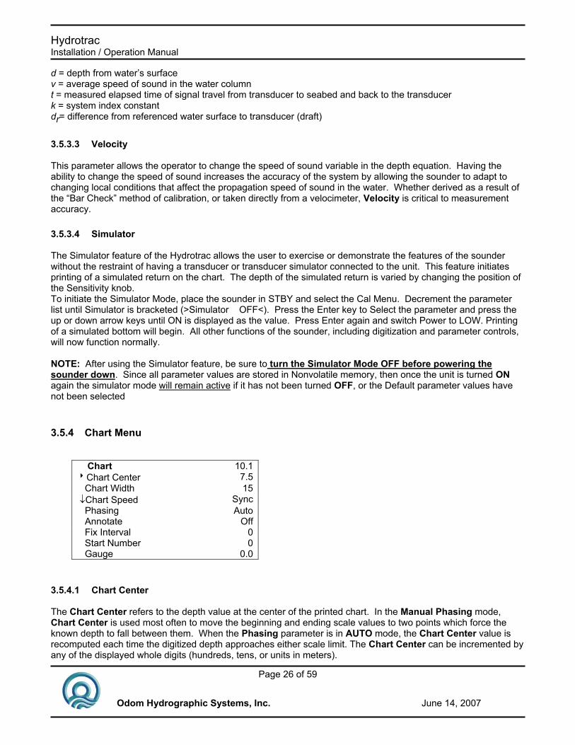
3.5.4 Chart Menu
Chart 10.18Chart Center 7.5 Chart Width 15 ↓Chart Speed Sync Phasing Auto Annotate Off Fix Interval 0 Start Number 0 Gauge 0.0
3.5.4.1 Chart Center The Chart Center refers to the depth value at the center of the printed chart. In the Manual Phasing mode, Chart Center is used most often to move the beginning and ending scale values to two points which force the known depth to fall between them. When the Phasing parameter is in AUTO mode, the Chart Center value is recomputed each time the digitized depth approaches either scale limit. The Chart Center can be incremented by any of the displayed whole digits (hundreds, tens, or units in meters).

Hydrotrac Installation / Operation Manual
Page 27 of 59
Odom Hydrographic Systems, Inc. June 14, 2007
3.5.4.2 Chart Width Scale limits printed on chart. End a scale value computes listening time and repetition rate. Values: 10,20,40,80 meters; 30,60,120,240 feet.
3.5.4.3 Chart Speed The actual rate at which the chart record is printed and paper advanced across the front panel is determined by the Chart Speed parameter. Possible speeds range from Sync. (each sounding is represented by one dot row (maximum print density)) to a number of fixed ranges selectable from 1 to 8 inches/min. Changing the speed also affect the number of shades the printer is capable of printing. 0-5 are 8 shades, 6-8 are 4 shades
3.5.4.4 Phasing The Phasing control determines whether or not the sounder will be allowed to automatically recompute the Chart Center value to avoid losing the bottom off the chart. Two selections are possible; Auto and Manual. In Manual, the Phase does not change as the depth changes. It remains fixed at the center value selected. However, in Auto, as the bottom approaches the chart limits, a new Chart Center is recomputed automatically and the Phase is adjusted so that the bottom is always plotted on the chart.
3.5.4.5 Annotate Annotation of the printed record by internally generated data (printed at each Fix Mark) is controlled by turning the Annotation parameter OFF or ON. With Annotation ON, each manual Fix Mark results in the depth, time, and date being printed on the Fix Line (Figure 3.6). Annotation OFF results in a single black line being printed across the chart. Manual Fix Marks are initiated by depressing the front panel MARK switch or by sending a Mark signal to the unit via the external Mark circuitry. This method should be distinguished from Fix Marks which are generated by an external computer and transmitted to the unit via the Serial Port.
3.5.4.6 Fix Interval/Start Number Related to Annotation, take advantage of the system’s internal clock to automatically generate Fix Marks on the chart, based on time between Fixes (Fix Interval), to number them sequentially, and to set the number at which to begin counting (Start Number). The Start Number can be either positive or negative however, the count direction is always positive.
3.5.4.7 Gauge Entering a value for GAUGE results in a line offset from the bottom return by the value entered, being printed on the sounder’s chart. This feature is intended to produce evidence of the collection of GAUGE data during the survey. The value entered for gauge does not change either the displayed depth or the digital output of the HYDROTRAC. The GAUGE line is often used as a tracking confirmation indicator, since the line is continuously printed at an offset from the digitized bottom.
F ix L in e
W a te r D e p th
T im e
D a te
E v e n t N u m b e r

Hydrotrac Installation / Operation Manual
Page 28 of 59
Odom Hydrographic Systems, Inc. June 14, 2007
3.6 Chart Controls Three pushbutton switches located at the top of the display panel above the display control the operation of the printer. The Chart ON/OFF switch is an alternate acting lighted pushbutton while both FEED and MARK switches are momentary acting.
3.6.1 ON/OFF Actuation of the Chart ON/OFF switch causes the printer to toggle between printing and not printing. The internal LED indicator serves to inform the operator of the status of the printer (ON – LED lighted, OFF- LED off) (Figure 3.7).
3.6.2 FEED Actuation of the FEED switch causes the printer to advance blank paper until the switch is released. This is useful in paper loading and in providing a blank area of chart in which to add handwritten annotation.
3.6.3 MARK The MARK switch is pressed whenever a “Fix Mark” or Mark Line is required on the chart. This circuit is paralleled by two contacts in the side panel mounted “Aux connector.” The configuration can be changed to suit a contact closure (standard).
Figure 3.7
Chart Controls

Hydrotrac Installation / Operation Manual
Page 29 of 59
Odom Hydrographic Systems, Inc. June 14, 2007

Hydrotrac Installation / Operation Manual
Page 30 of 59
Odom Hydrographic Systems, Inc. June 14, 2007
4 INTERFACING
4.1 Computer Communications Due largely to the pervasive presence of PC based data acquisition systems aboard survey vessels, the need has arisen for echo sounders to communicate quickly and easily in a digital format. Two of the most common communications interface formats are RS-232C and RS-422. The Comm 1 port in the Hydrotrac is capable of sending and receiving data in both formats. In its standard configuration, the unit sends ASCII characters at 9600 baud, (8 data bits, 1 start bit, 1 stop bit, no parity) to peripherals or data logging systems at the completion of each sounding cycle. Comm 1 is a bi-directional serial port with the capability of accepting input data as well as outputting serial depth information. A description of the protocol required for changing the default output format and for printing annotation follows in this section.
4.1.1 Serial Output Strings
4.1.1.1 Echotrac I/O ECHOTRAC I/O is the standard serial output string first introduced in the Echotrac DF 3200 MKI in 1985. Due to the wide acceptance of this string and the availability of the format in a number of data acquisition systems, the string has been maintained in order to assure continued compatibility. Please note that characters 2 & 3 are lower case whenever the Units parameter selected is Meters (centimeter resolution). The foot serial output string varies from the metric string in that characters 2 & 3 are always upper case (tenths of feet).
Char. # Description 1 Normally Space “F” Indicates
Fix Mark 2 “E” foot units, tenths res.
“e” metric units cm. Resolution 3 “T” foot units, tenths res.
“t” metric units cm. Resolution 4 Normally a Space “E” indicates
Error 5 Always a space 6 Depth Data (MSD) 7 Depth Data 8 Depth Data 9 Depth Data 10 Depth Data (LSD) 11 Carriage Return
Hydrotrac Installation / Operation Manual
Page 31 of 59
Odom Hydrographic Systems, Inc. June 14, 2007
4.1.1.2 Heave Note that upon selection of Heave IN on Comm 2, and Echotrac I/O on Com 1, the depth output from Comm 1 is automatically corrected for the received Heave value. Selection of Heave Out on Comm 1 (see Section 3-18) results in an output string containing the raw (uncorrected depth) and the most appropriate heave value. Note this string is identical to the Echotrac DBT string with one channel selected and Heave enabled.
Char. # Description 1 Normally Space “F” indicates Fix Mark 2 “E” decimeter resolution “e” centimeter 3 “T” decimeter resolution “t” centimeter 4 Normally Space, “E” Indicates Error 5 Frequency Indicator Fixed “H” 6 Always Space 7 - 11 Depth data 12 “+ or –“ 13-16 Heave Data 17 Carriage Return
4.1.1.3 DESO 25 The following description applies when DESO25 I/O is selected as the preferred output string under Comm 1.
Char. # Description 1 Always “D” 2 Always “A” Channel 1 3 Depth Data (MSD) 4 Depth Data 5 Depth Data 6 Depth Data 7 Depth Data 8 Decimal Place (.) 9 Depth Data 10 Depth Data (LSD) 11 Space meters “F” Feet units 12 “m” meters “t” feet units 13 Carriage Return 14 Line Feed
Hydrotrac Installation / Operation Manual
Page 32 of 59
Odom Hydrographic Systems, Inc. June 14, 2007
4.1.1.4 NMEA String (DBS) Included in the choices of serial output formats, is the DBS string. This string is included in order to provide a standard global format. It is widely accepted and therefore more easily interfaced to software suites written for applications outside of the Hydrographic community. The NMEA String as transmitted by the Hydrotrac has the following parameters: Baud Rate: 9600 Stop Bit: 1 Parity: None Data Bits: 8 Terminator: Cr/Lf
Char. # Description 1 Always a “$” Sign 2-6 Always SDDBS 7 Always a comma “,” Next Field Depth in feet (may be no
chars) Next Char Always a comma Next Char “f” for feet (may be no chars) Next Char Always a comma Next Field Depth in Meters (may be no
chars) Next Char Always a comma Next Char “M” for meters (may be no
chars) Next Char Always a comma Next Field Depth in fathoms (may be no
chars) Next Char Always a comma Next Char “F” for fathoms (may be no
chars) Next Char “*hh” numeric checksum char <CR><LF>
4.1.2 Serial Data Input and Annotation Information, which in the past had to be handwritten on the chart record, can now be transmitted to the Echotrac via the RS232 input line. Up to 80 ASCII characters per line can be printed on the chart.
4.1.2.1 Event Line (Fix Mark) A single line across the chart is produced by sending a HEX 06 (ASCII “ACK” or “Control F”). An event line will be printed across the chart at the end of the current sounding cycle. Event lines do not delay or interfere with normal operation of the unit.

Hydrotrac Installation / Operation Manual
Page 33 of 59
Odom Hydrographic Systems, Inc. June 14, 2007
4.1.2.2 Event Annotation When required, the event line can be annotated with up to 80 characters of information. This is achieved by following the HEX 06 (Fix Mark) with HEX 01 (ASCII “SOH” or “Control A”). As in the earlier models of the Echotrac, the sounder will respond to the “Control A” with a HEX 02 (ASCII “STX” or “Control B”). However, it is no longer necessary to wait for the “Control B” before sending annotation data. Data may be sent to the Echotrac immediately after transmission of the “Control A”. The “Control B” was retained in order to remain “downwardly compatible”.
4.1.2.2.1 ETMark1 Serial Output: Once the HEX 02 is transmitted, annotation characters can be sent sequentially or with breaks between characters. The ASCII string should be delimited by a HEX 04 (ASCII “EOT” or “Control D”). This will cause the annotation to be printed and will return the ECHOTRAC to normal operation. Note: Event annotation must contain at least one character before the HEX 04 delimiter even if it is only a HEX 20 (“space”). Care should also be taken to avoid annotation overrun which is caused by grouping annotated events so closely together that they obscure the record.
4.1.2.2.2 HEADER INFORMATION (Multiple Lines of Text) This type of information would normally be hand-written at the start or end of a survey line and would include text relating to date, time, work area, etc. Using the Heading Information input facility it is possible to have this information printed automatically on a blank section of chart. Each line is still limited to the maximum of 80 characters but there is no limit to the number of lines of annotation. Header information is sent in the same way as Event Annotation (see above) except that a HEX 0D (ASCII “CR”) delimits each line of information. The HEX 04 (“Control D”) is transmitted only at the end of the complete header text. The following procedure steps through each phase of the Header Information input: 1) Transmit HEX 01 to request an annotation input. 2) Transmit a line of header information up to a maximum of 80 characters. 3) Transmit HEX 0D (“CR”) to print the line. 4) Transmit next line of Header Information. 5) Repeat step 3 and 4 as required until all Header Information is sent. 6) After the last “CR”, send the HEX 04 delimiter to return ECHOTRAC to normal operation. 7) In order to advance blank paper, send the HEX 0D (“CR”) as many times as necessary.
4.1.3 EXTERNAL CONTROL OF UNIT PARAMETERS
4.1.3.1 INTRODUCTION Many of the parameters entered via the front panel keypad may also be entered via the serial port from an external computer or terminal. The external control feature allows remote input of the operating parameters from data files or through the computer keyboard. Some restrictions apply to external parameter inputs which, because of their absolute nature, are only tested against minimum and maximum limits. Front panel changes on the other hand are always processed in a controlled fashion in order to prevent possible system errors. Most often problems arise if the external parameter input is not in the correct multiple for the parameter addressed. For example, changing the ChartWidth from 10,20,40, to 60 m on the front panel is accomplished by pressing the UP button twice. With each actuation, the width is only allowed to double and the proper multiple is always added or subtracted to the last value. If however, a ScaleWidth of 47.7 m is received on the serial input, the unit will process it and attempt to adjust all parameters accordingly. The result being system errors will follow. These may be so extensive that only loading the default setup procedure will recover the system.

Hydrotrac Installation / Operation Manual
Page 34 of 59
Odom Hydrographic Systems, Inc. June 14, 2007
4.1.3.2 PROTOCOL 12 ASCII bytes maximum are necessary to complete a parameter transfer as shown below: The sequence begins when HYDROTRAC receives a CONTROL P (ASCII DLE, HEX 10) followed immediately
by the parameter control string (The parameter number (2 characters) followed by a SPACE (HEX 20) then the parameter value itself (which can be up to 8 characters long) followed by a carriage return). The transfer is then complete and the HYDROTRAC returns to normal operation using the new value. In the above example the VELOCITY identified by the parameter number 08 was changed to a new value of 1464 m/s. The string delimiter (CR) will always terminate the input. Use Control T (HEX 14) to stop the chart and Control R (HEX 12) to restart the chart. In order to provide continuity in interfacing to systems, which were programmed for the older model ECHOTRAC, the MKII will immediately respond to the CONTROL P with transmission of a CONTROL B (ASCII STX, HEX 02). As shown in the table below each parameter is identified by a unique number. Table 6.1 is also a consolidated table for reference purposes. It shows all the possible parameters with their increment, multiple, minimum, and maximum values and an example input code. Additional descriptions of parameters can be found in Section 4.2 of this manual.
No. Description Increment (Special case) Multiple Min-Max 1 Phasing 1 (0=auto,1=manual) 0-1 2 RESERVED 3 Chart Center * 1 ft, 1 mt 15-985 ft, 5-295 mt.
4 Chart width * 30,60,120,240 ft. 10,20,30,80 mt.
5 RESERVED 6 RESERVED 7 Bar gate depth * 1 ft, 1 mt 1-100 ft, 1-40 mt.
8 Velocity 1 ft 1 mt 4500-5600 ft
1370-1700 mt 9 Timeset (hhmmss) hh:1,mm:1,ss:1 hh:0-23,mm:0-59,ss:0-59 10 Dateset (mmddyy) mm:1,dd:1,yy:1 mm:0-12,dd:0-31,yy:0-99 11 RESERVED 12 Minimum depth 1 ft, 1 mt. 0-100 ft, 0-30 mt 13 RESERVED 14 Chartspeed 1 0-8 15 Draft 0.1 ft, 0.01 mt 0-50 ft, 0-15 mt 16 RESERVED 17 RESERVED 18 Start number 1.00 -32767-32767 19 RESERVED 20 Time interval 1.00 0-999 21 RESERVED 22 RESERVED
Consolidated Parameter Reference Table
<Parameter Number>'Space'<New Value>CR
12 Characters Maximum
Ex: '0' '8' 'SPACE' '1' '4' '6' '4' CR

Hydrotrac Installation / Operation Manual
Page 35 of 59
Odom Hydrographic Systems, Inc. June 14, 2007
The parameter IDs that you use to send settings are not the same as when you request settings. For example, to set the chartspeed you would use a parameter ID '14' that is different from the parameter ID '09' when you request the Chartspeed setting. After the Hydrotrac new equipment such as the MK3, Echotrac CV and HT100 were developed which use a larger set of parameters. In order to maintain backwards compatibility we had to keep the Hydrotrac's way of setting parameter settings the same. To query a setting use the following 6 character sequence: <CTRL+P><Request ID><space><Parameter ID> The Hydrotrac will then reply with “#HTC,P,”<UNITS><PING NUMBER><PARAMETER ID><VALUE>. The Units is a single character F or M for Feet or Meters. The ping number is 8 characters, the Parameter ID is 2 characters and the value is 8 characters. Example: <CTRL+P>71 00 #HTC,P,F000000010000000168 The following table lists the settings that can be queried.
No. Description Min-Max 0 Range
1 Velocity 4500-5600 ft 1370-1700 mt
2 Chart center 15-985 ft, 5-295 mt.
3 Chart width 30,60,120,240 ft. 10,20,30,80 mt.
4 Draft 0-50 ft, 0-15 mt 5 Bar gate depth 1-100 ft, 1-40 mt. 6 Blanking 7 Minimum depth 0-100 ft, 0-30 mt 8 Gauge 9 Chartspeed 0-8 10 Index 11 Units 0=feet, 1=meter
12 Com1
0=Echotrac I/O 1=NMEA GLL in 2=NMEA GGA in 3=NMEA DBS out 4=DESO25 I/O 5=ET MK1 I/O 6=Heave out
13 Com2
0=off 1=Heave in 2=NMEAGGA in 3=NMEA GLL in
14 Com1 baudrate 0=4800,1=9600,2=19200 15 Com2 baudrate 0=4800,1=9600,2=19200 16 Scalemode 0=auto,1=manual 17 Annotate 0=off,1-on 18 Fixint 19 Startnum -32767-32767 20 Alarm 0=off,1-on 21 External Trigger 0=off,1-on 22 simulator 0=off,1-on 23 Language 0=English,1=German/Spanish

Hydrotrac Installation / Operation Manual
Page 36 of 59
Odom Hydrographic Systems, Inc. June 14, 2007
4.2 Sensor Inputs
4.2.1 GPS A GPS outputting NMEA GLL or GGA can be connected to the Hydrotrac in either Com1 or Com2. Selection of GLL IN will cause the most recent “X,Y” position to be printed on the chart at every Fix Mark and on the LCD display. Selection of GLL IN and NMEA DBS OUT at the same time will result in the “X” and “Y” values being appended to the DBS string. This concatenation is intended to be used in applications where only one serial port is available to store data.
4.2.2 Heave Sensor Comm 2 may also be used to take in Heave data from a motion sensor. Selection of Heave IN under Comm 2 results in a raw Heave line, the corrected seabed, and the raw seabed, all being printed on the Hydrotrac chart in real-time. The output string is also corrected for the most current Heave value. The port is configured to accept the TSS standard string.
4.3 AUXILIARY Port The Auxiliary connector provides access to the analog Mark circuit, the external trigger, transmit inhibit, trigger output, and receiver output.
4.3.1 EXTERNAL TRIGGERING Individual sounding cycles can be controlled through the Auxiliary port. The external trigger mode is initiated by selecting External Trigger ON in the Setup Menu. Once this mode of operation is initiated, a falling edge (TTL pulse) on the Trigger input of the Auxiliary port begins the sounding cycle. At the end of the cycle, a digital depth is generated and output from the Comm 1 port. This sequence of events ends the cycle and another sounding will not be initiated until a subsequent falling edge is detected or the sounder is taken out of the External Trigger Mode.
4.4 UPDATING FLASH MEMORY As new versions of the HYDROTRAC’s embedded code are released, they are made available to customers via Odom’s webpage (http://www.odomhydrographic.com). There you will find an executable file called “HTCOMM”. This is a utility to download new software into the HYDROTRAC depth sounder. To download new software, connect your PC to HYDROTRAC’s Com 1 plug using a standard 3 wire serial cable. With the HYDROTRAC OFF, hold down the FEED and CHART buttons on the front panel and switch POWER to STBY. The display will indicate “Flash Mode” and the CHART ON/OFF LED will be OFF. Start the “htcomm” program. Choose option 1 to select the Com port you’re using on your computer. Select option 2 to download all processors. Specify a directory containing the “.bin” files. For example, if you create a directory on the C drive called HT_CODE, you would specify C:\HT_CODE. The program should begin downloading the code. The time required will vary, but should not exceed 15 minutes. When download is complete, cycle power on the HYDROTRAC to start the new software. For help with this function, visit our website ‘www.odomhydrographic.com’ or call Odom Hydrographic Systems in the USA at (225) 769-3051.

Hydrotrac Installation / Operation Manual
Page 37 of 59
Odom Hydrographic Systems, Inc. June 14, 2007
5 CALIBRATION The principle of echo sounding is based on measuring the time of arrival of an acoustic return (echo) referenced to the time of transmission. The time required for sound to travel from a source (the transducer) to the seafloor or bottom, and back can be measured and multiplied by the velocity of sound in water in order to arrive at the distance the pulse has traveled. Since the transmitted pulse has traveled from the transducer to the bottom and back again, then the distance must be halved in order to obtain the water depth. As shown in the general depth formula below, other factors enter into the equation as well. d = v x t -k +dr 2
Where: d - Depth from referenced water surface. v - Average velocity of sound in the water column. t - Measured elapsed time from the transducer to the bottom and back to the transducer. k - System index constant. dr - Distance from reference water surface to the transducer (draft) Since depth measurement accuracy is dependent on the value used for the velocity of sound in water (along with the other factors shown above) it is important that a realistic value for sound velocity be determined. In water, velocity is a function of temperature, salinity and pressure. Understandably then, the local sound velocity may vary widely, thereby resulting in the need to calibrate any type of echo sounder, in order to provide the most accurate depth data at a given location. The most common calibration technique is the bar check method. This method, when employed properly, has the advantage of correcting for velocity variations, draft variations, and system index errors (all of the constants in the above formula). When calibrating using the bar check method, acoustic returns are generated by a suspended target which is lowered to a known depth between the transducer and the bottom. In this circumstance it becomes desirable to have a method whereby the digitizer will see only the Bar (the target) and be prevented from locking on to actual bottom returns. Since the Hydrotrac employs a dynamic tracking gate or window through which the digitizer looks for echoes from the seabed, manual control of the position and width of the gate is necessary in order to force it to remain fixed around the Bar. This is achieved by using the Bar Depth function.
5.1 BAR CHECK CALIBRATION As indicated in paragraphs 3-23 through 3-24, the Calibrate Menu brings all of the parameters necessary to calibrate the sounder together in one display group. By pressing the Cal key, the operator is presented with the following menu:
Calibrate 10.01 8Bar Depth 10 Draft 1.6 ↓ Index .7 Velocity 1500
NOTE: HEAVE IN must be OFF and the unit’s power and sensitivity adjusted to levels which provide reliable depth information from the project depth and bottom material.

Hydrotrac Installation / Operation Manual
Page 38 of 59
Odom Hydrographic Systems, Inc. June 14, 2007
1. With Bar Depth parameter bracketed, press the Enter key. Enter the first calibration depth. That is, the measured depth of the “Check Bar” at its shallowest calibration depth.
2. Deploy the Check Bar below the transducer to the first calibration depth (for example 2 meters or 10 ft.).
Confirm that a return is printed on the chart between the two Bar Depth lines, and that the digitizer is locked to the Bar. Select the Draft parameter (bracket it and press ENTER). Slew the Draft value to the depth of the transducer from the water surface.
3. Slew the Index value until the Calibrate Depth equals the depth of the Check Bar (determined from the
suspension chain). 4. Lower the Check Bar to the deepest calibration depth, for example 15 meters (40 ft.) and adjust the Bar Depth
value to equal the depth of the Check Bar. 5. Select Velocity. Slew the Velocity up or down to the point at which the Calibrate Depth equals the measured
depth of the Check Bar. 6. Repeat Steps 4 to 5 until the Calibrate Depth equal the Check Bar depth at the shallow and deep checks.
7. IMPORTANT! Adjust Index only when the BAR is at the shallowest depth (where velocity has minimum
effect) and VELOCITY only when the BAR is lowered to greater depths (where velocity becomes predominant).

Hydrotrac Installation / Operation Manual
Page 39 of 59
Odom Hydrographic Systems, Inc. June 14, 2007

Hydrotrac Installation / Operation Manual
Page 40 of 59
Odom Hydrographic Systems, Inc. June 14, 2007
Appendix A. Using Hydrotrac with built in Starlink Invicta DGPS Introduction: The internal DGPS receiver option for the Hydrotrac is intended to provide the user with a compact and rugged hydrographic survey tool. With the addition of a data acquisition computer and appropriate software, a complete survey system can be achieved with only two “boxes.” This can be a great advantage in remote or otherwise inaccessible areas where portability, quick mobilization, and ease of operation are important. As shipped from the factory, the Starlink Invicta 210 DGPS board is configured to use the integral MSK beacon receiver for differential corrections, and to output the GLL string on COM 2. This standard configuration can easily be changed using the program GPSMon.exe. The setup program is provided on disk with the unit, and can also be downloaded from Star Link’s web site at www.starlinkdgps.com. The program runs on any PC running the Windows operating system. Set up information is exchanged through one of the serial ports on the PC and COM 1 of the Hydrotrac. Changes in the configuration do not require the operator to physically access the board. When a GPS receiver is installed in the Hydrotrac, or GPS data is input to the unit, latitude and longitude can be displayed alternatively with the Depth display. Access to the latitude and longitude display is gained by pressing the DEPTH key (toggles between the large Depth display and the latitude and longitude at each actuation). The following paragraphs describe the various configurations available for the combined system. The DGPS board supports 2 serial ports, Com A and Com B. These two ports are accessed through the Hydrotrac’s Com 1 and Com 2 ports respectively. Each Hydrotrac with “built-in DGPS” is supplied with two serial cables. Each serial cable is equipped with a pair of DB9S connectors plus mating “MS” type connectors for the Hydrotrac’s two Com ports. The DB connectors are labeled for either DGPS or Hydrotrac. As one would expect, the connectors labeled Hydrotrac are for access to the Hydrotrac’s Com ports, while the connectors labeled DGPS access Com A and Com B of the DGPS receiver directly.
Hydrotrac depth output and DGPS output through separate ports In order to receive depth and position data on two separate Com ports (for example Com 1 and Com 2 of a data acquisition computer), you will need to connect cables from both Com1 and Com2 of the Hydrotrac. Connect the DB9 connector labeled “Hydrotrac” on COM 1 of the sounder to receive depth data, and the DB9 connector labeled “DGPS” on Com2 of the Hydrotrac to get the DGPS position data.
Fig 1
DEPTH
POSITION
DGPS ANTENNA
COMPUTER
HYDROTRAC COM 1 COM 2
Heave

Hydrotrac Installation / Operation Manual
Page 41 of 59
Odom Hydrographic Systems, Inc. June 14, 2007
Configuration of the DGPS board to output the various NMEA sentences available (stored in memory on the Invicta board), requires the use of the DB9 connector on COM 1 of the sounder labeled “DGPS” to be connected to the serial port of your computer. Run the Starlink Invicta software (see the Starlink manual for more information) and select from the various configuration options.
Hydrotrac depth output and DGPS output through one port With the built in DGPS receiver the Hydrotrac has the capability to output position and depth through one serial port. This is helpful for operators having a computer with only one serial port. Once this configuration is selected, both depth and position values are output in the NMEA format. However, there are a few drawbacks to this configuration. 1) Only the NMEA GLL sentence is available for position. This is done because the GLL sentence is the shortest of the NMEA position sentences and consequently has the least amount of latency associated. 2) The latency of the depth sentence (DBS) is different than the latency of the position sentence. The difference in latencies can introduce unacceptable errors in the position calculations when surveying at speeds of greater than 6 knots. If the processing software used to log the data can adjust for both of these latencies, then it is not a problem. Set Up: Set the Hydrotrac to output the NMEA DBT sentence through COM1 and to accept the NMEA GLL sentence via COM2. Using the DB9 connector on COM1 labeled DGPS, set the Starlink Invicta DGPS receiver to output the GLL sentence only through port B at a baud rate of 9600 (see Starlink manual for more information). Place a jumper between pins D and G on the COM 2 connector of the Hydrotrac (Jumper Connector Supplied).
Fig 2
DEPTH / POSITION
DGPS ANTENNA
COMPUTER
HYDROTRAC COM 1 COM 2
Jumper Pins D and G
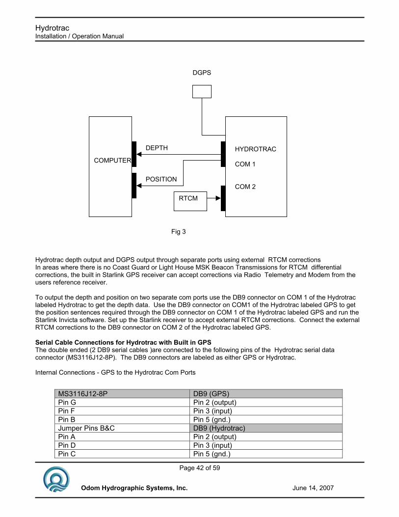
Hydrotrac Installation / Operation Manual
Page 42 of 59
Odom Hydrographic Systems, Inc. June 14, 2007
Hydrotrac depth output and DGPS output through separate ports using external RTCM corrections In areas where there is no Coast Guard or Light House MSK Beacon Transmissions for RTCM differential corrections, the built in Starlink GPS receiver can accept corrections via Radio Telemetry and Modem from the users reference receiver. To output the depth and position on two separate com ports use the DB9 connector on COM 1 of the Hydrotrac labeled Hydrotrac to get the depth data. Use the DB9 connector on COM1 of the Hydrotrac labeled GPS to get the position sentences required through the DB9 connector on COM 1 of the Hydrotrac labeled GPS and run the Starlink Invicta software. Set up the Starlink receiver to accept external RTCM corrections. Connect the external RTCM corrections to the DB9 connector on COM 2 of the Hydrotrac labeled GPS. Serial Cable Connections for Hydrotrac with Built in GPS The double ended (2 DB9 serial cables )are connected to the following pins of the Hydrotrac serial data connector (MS3116J12-8P). The DB9 connectors are labeled as either GPS or Hydrotrac. Internal Connections - GPS to the Hydrotrac Com Ports
Fig 3
DEPTH
POSITION
DGPS
COMPUTER
HYDROTRAC COM 1 COM 2
RTCM
MS3116J12-8P DB9 (GPS) Pin G Pin 2 (output) Pin F Pin 3 (input) Pin B Pin 5 (gnd.) Jumper Pins B&C DB9 (Hydrotrac) Pin A Pin 2 (output) Pin D Pin 3 (input) Pin C Pin 5 (gnd.)

Hydrotrac Installation / Operation Manual
Page 43 of 59
Odom Hydrographic Systems, Inc. June 14, 2007
Starlink DB9 Connector (the one on the GPS board)
Signal Name Hydrotrac Connection
Pin 2 Port A output MS3116J12-8P Com 1 Pin G Pin 3 Port A input MS3116J12-8P Com 1 Pin F Pin 4 Port B input MS3116J12-8P Com 2 Pin F Pin 6 Port B output MS3116J12-8P Com 2 Pin G Pin 8 Power 24 Volts on Hydrotrac Pin 9 GND GND on Hydrotrac
Notes: All the individual dip switches on SW1 are set to the OFF position. This allows for configuration of the GPS board via the serial port. Heave correction is always interfaced via the DB9 connector on COM 2 labeled Hydrotrac. For other custom configurations please contact the factory

Hydrotrac Installation / Operation Manual
Page 44 of 59
Odom Hydrographic Systems, Inc. June 14, 2007
Hydrotrac Installation / Operation Manual
Page 45 of 59
Odom Hydrographic Systems, Inc. June 14, 2007
Appendix B. Side Scan Operating Procedures: Deployment and operational recommendations: The Hydrotrac Side Scan Option utilizes the high-resolution gray scale thermal printer and the standard controls of the Hydrotrac to produce quality side looking sonar images. An example of a Side Scan record follows. In this application, a 200 kHz, pole mounted, side scan transducer is simply connected in place of the standard “down-looking” transducer. The side scan beam is relatively wide in the across track direction (45° vertical) and narrow in the along track direction (0.7° horizontal). In order to present as shallow an angle as possible to the bottom and to avoid reflections from the water surface, the transducer should be mounted as deeply as possible (at least 1-2 meters below the surface). It should be mounted rigidly and guyed both fore and aft in order to keep vibration from degrading the record. The mounting bracket allows for a range of depression angles of the transducer beam. The depression angle should be adjusted based on observations from the chart record. However, in general, it should be set so that the transducer is pointing slightly downward from the horizontal. This usually gives the best overall gain across the chart record. If the initial return from the bottom is very strong and the extreme range is very weak, the transducer is probably pointing down at too great an angle. Rotating the transducer up toward the water’s surface will improve the overall record quality. Initial Settings: Analog Controls: SENSITIVITY 3 o’clock POWER Med Parameter Values: SYSTEM MENU Phasing (Scale) MAN ChartCenter 10 M ChartWidth 20 M ChartSpeed SYNC SENSITIVITY, and POWER settings should be adjusted so as to obtain the best printed record possible. Generally, the SENSITIVITY control will have the greatest effect on the recording. Do not be tempted to set the SENSITIVITY too high or data may be lost due to excessive blackening of the record at the near bottom. The ChartWidth and ChartCenter parameters should be set to suit the situation. ChartWidth can be set at a value to 10m to 80m depending on the mission. An increase in ScaleCenter settings brings the initial bottom return closer to the top of the chart, thus eliminating much of the water column and getting more bottom data printed on the record. Please note that although the Hydrotrac will often successfully digitize the first return from the Side Scan transducer, it is not our objective to provide both Side Scan imaging and bathymetry simultaneously. The side scan option is strictly an imaging tool!
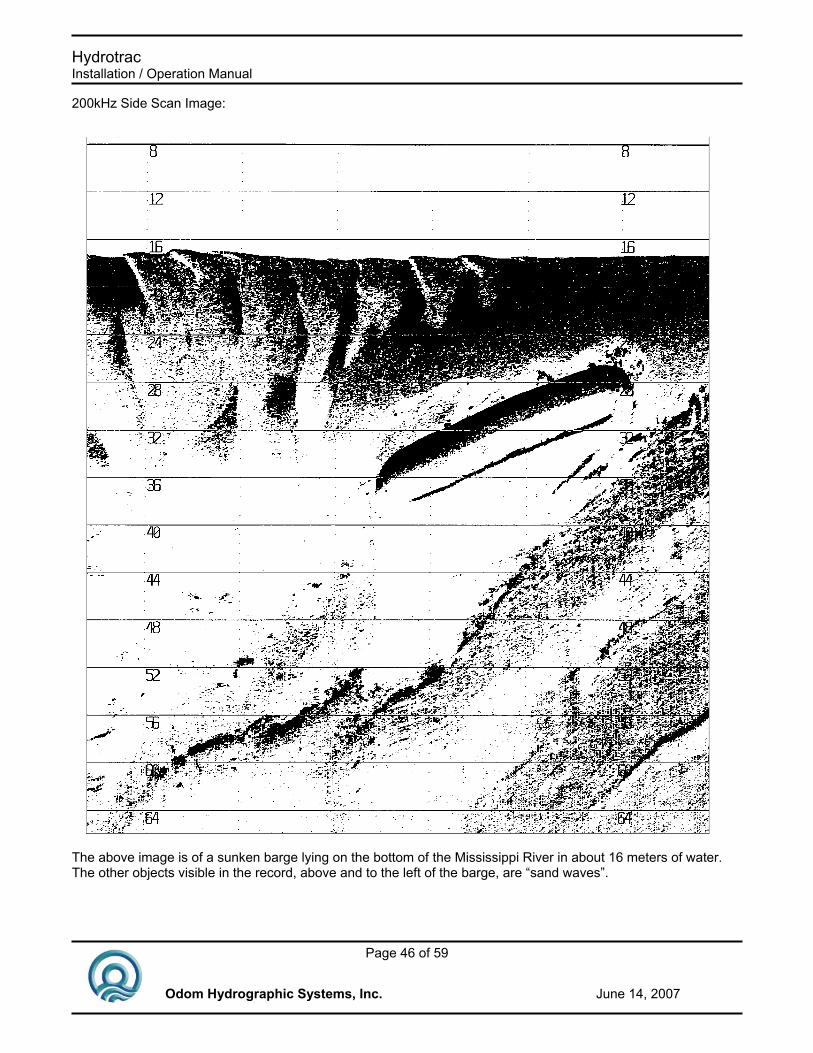
Hydrotrac Installation / Operation Manual
Page 46 of 59
Odom Hydrographic Systems, Inc. June 14, 2007
200kHz Side Scan Image:
The above image is of a sunken barge lying on the bottom of the Mississippi River in about 16 meters of water. The other objects visible in the record, above and to the left of the barge, are “sand waves”.

Hydrotrac Installation / Operation Manual
Page 47 of 59
Odom Hydrographic Systems, Inc. June 14, 2007

Hydrotrac Installation / Operation Manual
Page 48 of 59
Odom Hydrographic Systems, Inc. June 14, 2007
Appendix C. Help Printouts A “HELP” printout is provided for each operational parameter accessed via the LCD display and the UP/DOWN buttons. When a parameter is selected and the HELP button pressed, an explanation of that parameter, its default value, minimum and maximum values, and increment are printed on the chart.
HYDROTRAC “HELP” PRINTOUTS “SETUP” Blanking Prevents digitization of unwanted echos between the water surface and depth entered. Default 0.0 Minimum 0.0 Maximum 1,000.0 feet, 300.0 meters Increment 0.1 feet, 0.1 meters Minimum Depth Used to warn boat operator of shallow water. Any depths less than the value entered will sound the sonic alarm. Default 0 Minimum 0 Maximum 100 feet, 30 meters Increment 1 foot, 1 meter Units Operating units of the sounder Resolution in feet: 0.1 Resolution in metes 0.01 Range Maximum anticipated working range. Sets limit to which tracking gate will expand to search for the bottom. Default 360 feet, 150 meters Minimum 60 feet, 15 meters Maximum 1,800 feet 600 meters Increment 1 foot, 1 meter Com 1 Echotrac I/O Serial depth output in ECHOTRAC format. Also data input from computer for chart control and annotation. Com 1 Heave Serial depth output in ECHOTRAC format plus heave value appended to string. Also data input from computer for chart control and annotation. Com 1 NMEA GLL IN GPS input in GLL format for chart annotation at fix mark. No data is output, but heave compensation via Com 2. Com 1 NMEA GGA IN GPS input in GGA format for chart annotation at fix mark. No data is output, but heave compensation via Com 2. Com 1 NMEA DBS OUT Combines GPS position (via Com 2) with depth output string. Com 1 Deso 25 I/O

Hydrotrac Installation / Operation Manual
Page 49 of 59
Odom Hydrographic Systems, Inc. June 14, 2007
Serial depth output in Deso 25 format. Also data input from computer for chart annotation. Com 2 Heave IN Input of heave data (TSS format). Depth output via Com 1 is corrected for heave values. Raw heave and corrected sea bed printed on chart. Com2 NMEA GLL IN Input of GPS position for output via COM1 together with depth string. Com2 NMEA GGA IN Input of GPS position for output via COM1 together with depth string. Com2 Remote Display Outputs data to the optional Remote Display. Echo Alarm When switched “ON”, sonic alarm will warn if lost echo. Time Enter current time. Date Enter current date. EXT. Trigger Sounder transmission controlled from external source. To exit, power down Default OFF Print Parameters Prints a listing of all current parameter values. Communications port 1 – Speed 4800, 9600, or 19200 baud. Communications port 2 – Speed 4800, 9600, or 19200 baud; “CALIBRATE” Bar Depth Depth at which the “bar check” is performed. Any value other than 0 causes digitizer to center on that depth only. Bar must be in this “window” for digitizer to lock on. Default 0 Minimum 0 Maximum 100 feet, 40 meters Increment 1 feet, 1 meter Velocity Speed of sound in water. Can be set from Velocimeter, or adjusted during bar check to give correct depth reading. Default 5,000 feet/sec., 1500 meters/sec Minimum 4,500 feet/sec., 1,370 metes/sec Maximum 5,600 feet/sec., 1,700 meters/sec. Increment 1 foot/sec., 1 meter/sec.
Hydrotrac Installation / Operation Manual
Page 50 of 59
Odom Hydrographic Systems, Inc. June 14, 2007
Draft Value added to measured depth to adjust for the apparent depth of the transducer below the water surface. Default 0 Minimum 0 Maximum 50 feet, 15 meters Increment 0.1 feet, 0.01 meters Index Value subtracted from measured depth to adjust for the electronic delay of the transducer. Default 0 Minimum 0 Maximum 50 feet, 15 meters Increment 0.1 feet, 0.01 meters Simulator Depth simulator mode. Use the Sensitivity knob to change the depth. Disables the transmitter. “CHART” Chart Center Depth value at the center of printed chart. Used in MANUAL PHASING to set chart to a desired depth. Default 30 feet, 10 meters Minimum 15 feet, 5 meters Maximum 985 feet, 295 meters Increment 1 foot, 1 meter Chart Width Scale limits printed on chart. End of scale value computes listening time and pulse repetition rate. Default 60 feet, 20 meters Minimum 30 feet, 10 meters Maximum 240 feet, 80 meters Increment Feet x2, meters x2 Speed Rate at which paper is advanced. In SYNC, paper advances one row of print dots for each sounding. Default SYNC Minimum ?? Maximum 8 inches/minute, 20 centimeters/minute Increment 1 inch/minute, 1 centimeter/minute Phasing Auto or manual. In Auto, the chart automatically acquires and tracks the bottom. The chart changes to the next range when the bottom approaches the edge of the chart. Manual is used to restrict the chart to a certain depth. Annotate Annotation of each fix mark with internally generated Fix number, date, time and depth. Position will also be printed with each fix if GPS is connected to the sounder. Default OFF (fix line only)

Hydrotrac Installation / Operation Manual
Page 51 of 59
Odom Hydrographic Systems, Inc. June 14, 2007
Fix Interval Internal in seconds at which internally generated fix marks are printed. Default OFF Minimum 1 sec. Maximum 999 sec. Increment 1 sec. Start Number Number at which fixes will start. Default 1 Minimum -30,000 Maximum +30,000 Increment Gauge Tidal corrections can be entered here. Tide line is plotted on the chart. Default 0 Minimum -60 Maximum 60 Increment 0.1

Hydrotrac Installation / Operation Manual
Page 52 of 59
Odom Hydrographic Systems, Inc. June 14, 2007

Hydrotrac Installation / Operation Manual
Page 53 of 59
Odom Hydrographic Systems, Inc. June 14, 2007
Appendix D. Hydrotrac Thermal Printhead Cleaning Procedure
Position the unit on a desktop or other flat surface with its rear panel down (lying on its back). Open the chart access panel to the fully open and locked position. As shown in Figure 1 below, locate the printhead and the printhead heatsink.
Printhead Printhead Heat Sink
Figure 1 Remove the two multi-pin connectors attached to the printhead and stow then inside the unit and out of harms way. Note that a cable harness is attached by three clamps to the printhead heatsink. It is not necessary to remove this harness from its clamps in order to gain access to the printhead. Locate two brass colored self-tapping screws at each end of the printhead heatsink (see the photo below). These four screws attach the printhead and printhead heatsink to the printer frame. Removal of the four screws will leave the heatsink and printhead free to be rotated away from the normal printing position.

Hydrotrac Installation / Operation Manual
Page 54 of 59
Odom Hydrographic Systems, Inc. June 14, 2007
Printhead Assembly Mounting Screws
Figure 2 Please note that the printhead is held against the paper feed roller by spring pressure. Four springs attached to the printhead heatsink provide this pressure. Therefore, we suggest that a tapered tool (a scribe or a pointed center punch) be placed in the holes vacated by the mounting screws as they are removed.

Hydrotrac Installation / Operation Manual
Page 55 of 59
Odom Hydrographic Systems, Inc. June 14, 2007
On the opposite end of the printhead heat sink from that shown above, are two identical screws. However, access to these screws is limited by the motor mounting plate. In later models of the plate, two holes corresponding to the position of the screws, have been drilled in order to accommodate a cross-point or phillips screwdriver. Please see Figure 3.
Two Screw Access Holes in Motor Mounting Plate

Hydrotrac Installation / Operation Manual
Page 56 of 59
Odom Hydrographic Systems, Inc. June 14, 2007

Hydrotrac Installation / Operation Manual
Page 57 of 59
Odom Hydrographic Systems, Inc. June 14, 2007
Appendix E. Frequency Agile Hydrotrac Operation The HT03RC frequency agile Transceiver increases the flexibility of the Hydrotrac by providing the operator with access to a range of operating frequencies without the necessity of changing transceiver cards. Several frequencies are available, beginning with 24kHz and reaching up the spectrum thru 210 kHz. The frequencies are pre-programmed to match a variety of popular transducers. The frequency agile Hydrotrac can be used to great advantage in cases where an existing transducer must be used. Since the unit can be varied both in frequency and impedance, one's chances of satisfactorily matching an existing transducer are greatly enhanced. Because of its internal wiring, the unit also has the capability of being connected to many existing dual frequency transducers and switching between the two sets of elements without the necessity of switching connectors.
SW3
T2 C58
SW2
J2 HT03RC
SW1
Impedance 100/50 Ohm
Hi/Lo Freq.Cable
Switch
Hi/Lo Cable
Connector
Frequency Adjust Switch
Changing Frequencies: With the unit disconnected from its source of mains power, and the Power Switch in the OFF position, access the Transceiver card by opening the Chart panel to its maximum open and locked position. Locate the rotary switch (SW1) on the right front edge of the HT03RC card (top card in the card-rack). Using a small flathead screwdriver turn the dial on SW1 until the small arrow points to the single digit number corresponding to the frequency desired. A complete frequency list is provided below.
Switch Position Frequency Cable
Connection Switch
Position Frequency Cable Connection
0 24 kHz Low (C&D) 4 125 kHz High (B&E) 1 33 kHz Low (C&D) 5 192 kHz High (B&E) 2 40 kHz Low (C&D) 6 200 kHz High (B&E) 3 50 kHz Low (C&D) 7 204 kHz High (B&E) 8 208 kHz High (B&E) 9 210 kHz High (B&E)

Hydrotrac Installation / Operation Manual
Page 58 of 59
Odom Hydrographic Systems, Inc. June 14, 2007
Internal Wiring/Range Matching: Once the operating frequency has been determined it necessary to confirm that the unit's internal wiring matches that of the transducer to be used. Referring to the operating frequency range table above, confirm that the pin designations on the transducer match those of the appropriate frequency range. Alternating between the Low and High ranges can be accomplished by first locating SW2. The switch is mounted on the top (front) edge of the HT03RC Transceiver board at the end next to the output transformer. Note the HI and LO designation on SW2 and select the appropriate frequency range. The table below lists some popular transducer models, their pin-outs, and the matching Hydrotrac frequency range designation.
Transducer Model
Number Frequency Pin-Out
Range Designation
/ SW2 Switch
Position
Impedance SW1 position
SM200-9BR/SS 204 kHz B & E High 50 ohm
SM200-3BR 208 kHz B & E High 50 ohm HM33-20 33 kHz C & D Low 50 ohm
OTS200/24-6/20
(Dual Freq)
204 kHz 24 kHz
B & E C & D
High Low 50 ohm
SM200-4BR 204 kHz B & E High 50 ohm FM210-9 210 kHz B & E High 100 ohm
Impedance: The final possible adjustment is the impedance setting. The Hydrotrac provides a pair of windings on the output transformer. The first winding is designed to accommodate low impedance transducers of approximately 50 ohms. Most of the transducers shipped by OHSI are of the low impedance variety. However, many existing transducers are designed to operate at a higher impedance of approximately 100 ohms. In order to efficiently transfer power to these transducers, a 100 ohm winding has also been provided on the output transformer. Consult your transducer provider for impedance information.

Hydrotrac Installation / Operation Manual
Page 59 of 59
Odom Hydrographic Systems, Inc. June 14, 2007
Appendix F. Remote Display Option An optional Remote Display is available for the Hydrotrac. The Remote Display uses RS232 and can be directly connected to the Hydrotrac with a Hydrotrac serial cable. The Remote Display is powered by an adapter. Cconnect the Remote Display to the Hydrotrac via the Hydrotrac's Com 2 port using the supplied cable. The Hydrotrac will power up the Remote Display. Go to the Setup menu on the Hydrotrac and scroll down to Com 2 and select Remote Disp. Pressing the Mark button on the Remote Display will send a fix mark to the Hydrotrac. Pressing the Alarm button on the Remote Display will cause an alarm to sound if the Hydrotrac looses track of the bottom. The channel button has no function when used with the Hydrotrac.