172 - utah · 172 172 6 0 0 w 100s 2 0 0 w 8 0 0 w 4 0 0 w alifo n iaa ve 4715 s a w y 3500 s west...
TRANSCRIPT
80
201
80
154
111
172
172
5600
W
4100 S
7200
W
4800
W
8400
W
California Ave
4715 S
Bang
erter
Hwy
3500 S
West Valley City
Salt Lake City
Magna
Salt Lake CityInternationalAirport
Salt Lake International Center
Rocky MountainRaceway
ATK
15
15
80
15
215
80
15
215
Camp Williams
Salt Lake City
West Valley
West Jordan
Draper City
Bluffdale
South Jordan
Murray
Riverton
Sandy City
Herriman
Taylorsville
Midvale
Holladay
South Salt Lake
Lehi
Cedar Fort
DraperAlpine
Eagle Mountain
Highland
Saratoga Springs LindonAmerican Fork
Vineyard
Cedar Hills
Map Key
0 10.25 0.5 0.75 Mile Figure 11-1
Bicycle and PedestrianPaths - I-80 to4700 South
Study Area BoundaryInterstate/FreewayCollector/Arterial5800 West Freeway7200 West FreewayExisting Pedestrian and Bicyclist PathsProposed Pedestrian and Bicyclist Paths
TransitCenter & Mixed UseCenter RunningMixed UsePark-N-Ride Lot
2827
244326
32
23 41
3342
4567
294777
2568 64
6373
3075 74 34
132
173
154
7800 S
5400 S
111
48
154
New Bingham Hwy
Old Bingham Hwy
4700 S4715 S
10400 S
10200 SBingham Hwy
5415 S
Bang
erter
Hwy
6200 S
West Jordan
South Jordan
Kearns
Salt LakeAirport No. 2
JordanLanding
ATK
USANA
15
15
80
15
215
80
15
215
Camp Williams
Salt Lake City
West Valley
West Jordan
Sandy City
Draper City
Bluffdale
South Jordan
Murray
RivertonHerriman
Taylorsville
Midvale
Holladay
South Salt Lake
Lehi
Cedar Fort Eagle Mountain
Draper Alpine
Highland
Saratoga Springs Lindon
Orem
American Fork
Vineyard
Cedar Hills
Map Key
0 10.25 0.5 0.75 Mile Figure 11-2
Bicycle and PedestrianPaths - 4700 South to10400 South
Study Area BoundaryCollector/Arterial5800 West Freeway7200 West Freeway7200/5800 West FreewayExisting Pedestrian and Bicyclist PathsProposed Pedestrian and Bicyclist Paths
TransitCenter & Mixed UsePark-N-Ride Lot
30
64
72
75
31
71
62
14
1346
34
57
61
54
56 53
25
55
7
38
50
5152
90
89
91
133
Bang
erter
Hwy
11400 S
151
13400 S
140
154
Old Bingham Hwy
Redw
ood R
d
12600 S
12300 S
10400 S
Main St
Redw
ood
Rd
15
14600 S
68
71
11800 S
Bluffdale
South Jordan
Riverton
Herriman
Jordan Narrows
Daybreak
Camp Williams
J orda n Ri ver
15
15
80
15
215
80
15
215
Camp Williams
Salt Lake City
West Valley
West Jordan
Draper City
Bluffdale
South Jordan
Murray
Riverton
Sandy City
Herriman
Taylorsville
Midvale
Holladay
South Salt Lake
Lehi
Cedar Fort
DraperAlpine
Eagle Mountain
Highland
Saratoga Springs Lindon
Orem
American Fork
Vineyard
Cedar Hills
Map Key
0 10.25 0.5 0.75 Mile Figure 11-3
Bicycle and PedestrianPaths - 10400 South toUtah County Line
Study Area BoundaryInterstate/FreewayCollector/Arterial7200/5800 West FreewayExisting Pedestrian and Bicyclist PathsProposed Pedestrian and Bicyclist Paths
TransitCenter & Mixed UseCenter RunningMixed UsePark-N-Ride Lot
55
52503856
51
2120 25
3919
44
10 18
48
35357
12 37 138
65
9 14
1
17
15
4
11
134
15
REDWOOD
US 89
92
US 89
REDWOOD
US 89
146
197
68
68
73
Lehi
Eagle
Mou
ntain
Alpin
e
Sara
toga S
pring
s
High
land
Pleasa
nt Gr
ove
Ameri
can F
ork
Ceda
r Hills
Than
ksgiv
ing
Point
6000 West
9550 West
Camp
Willi
ams
Union
Pacifi
c
South
ern Pa
cific
Jordan
River
Jord
an
Narr
ows
140
15
1460
0 S
68
Camp
Willi
ams
Salt Lake CountyUtah County
Jordan River
15
15
80
15
215
80
15
215
Cam
p W
illia
ms
Salt
Lake
City
Wes
t Val
ley
Wes
t Jor
dan
Dra
per C
ity
Bluf
fdal
e
Sout
h Jo
rdan
Mur
ray Sand
y C
ity
Rive
rton
Her
riman
Tayl
orsv
ille M
idva
le
Hol
lada
y
Sout
h Sa
lt La
ke
Lehi
Ceda
r For
t
Dra
per
Alp
ine
Eagl
e M
ount
ain
Hig
hlan
d
Sara
toga
Spr
ings
Lind
on Ore
m
Am
eric
an F
ork
Vin
eyar
d
Ceda
r Hill
s
Map K
eyIns
et - P
orter
Rock
well
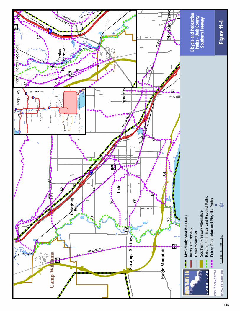
01
0.25
0.50.7
5Mi
leFigu
re 11-4
Bicycle a
nd Pedes
trianPath
s - Utah C
ounty
Souther
n Freew
ay
MVC
Study
Area
Boun
dary
Inters
tate/F
reewa
yCo
llecto
r/Arte
rial
South
ern Fr
eewa
y Alte
rnativ
eEx
isting
Pede
strian
and B
icyclis
t Path
sFu
ture P
edes
trian a
nd Bi
cyclis
t Path
s
78
80
84
82
37 5
8
4
1314
17
35
93
83
8179
8586
87
88
9
135

15
15
REDWOOD
US 89
92
US 89
REDWOOD
US 89
146
197
68
68
73
Lehi
Eagle
Mou
ntain
Lind
on
Sara
toga S
pring
s
High
land
Pleasa
nt Gr
ove
Ameri
can F
ork
Ceda
r Hills
Than
ksgiv
ing
Point
Utah
Lak
e
6000 West
9550 West
Camp
Willi
ams
Union
Pacifi
c
Southern P
acific
Jordan
River
Jord
an
Narr
ows
140
15
1460
0 S
68
Camp
Willi
ams
Salt Lake CountyUtah County
Jordan River
15
15
80
15
215
80
15
215
Cam
p W
illia
ms
Salt
Lake
City
Wes
t Val
ley
Wes
t Jor
dan
Dra
per C
ity
Bluf
fdal
e
Sout
h Jo
rdan
Mur
ray Sand
y C
ity
Rive
rton
Her
riman
Tayl
orsv
ille M
idva
le
Hol
lada
y
Sout
h Sa
lt La
ke
Lehi
Ceda
r For
t
Dra
per
Alp
ine
Eagl
e M
ount
ain
Hig
hlan
d
Sara
toga
Spr
ings
Lind
on Ore
m
Am
eric
an F
ork
Vin
eyar
d
Ceda
r Hill
s
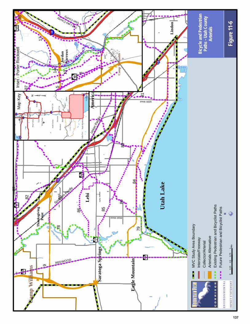
Map K
eyIns
et - P
orter
Rock
well
01
0.25
0.50.7
5Mi
leFigu
re 11-5
Bicycle a
nd Pedes
trianPath
s - Utah C
ounty
2100 Nor
th Freew
ay
MVC
Study
Area
Boun
dary
Inters
tate/F
reewa
yCo
llecto
r/Arte
rial
2100
Nort
h Free
way A
lterna
tive
Exist
ing Pe
destr
ian an
d Bicy
clist P
aths
Futur
e Ped
estria
n and
Bicy
clist P
aths
37 5
8
4
1314
17
35
93
78
80
84
82
83
8179
8586
87
88
9
136
15
15
REDWOOD
US 89
92
US 89
REDWOOD
US 89
146
197
68
68
73
Lehi
Eagle
Mou
ntain
Lind
on
Sara
toga S
pring
s
High
land
Pleasa
nt Gr
ove
Ameri
can F
ork
Ceda
r Hills
Than
ksgiv
ing
Point
Utah
Lak
e
6000 West
9550 West
Camp
Willi
ams
Union
Pacifi
c
Southern P
acific
Jordan
River
Jord
an
Narr
ows
140
15
1460
0 S
68
Camp
Willi
ams
Salt Lake CountyUtah County
Jordan River
15
15
80
15
215
80
15
215
Cam
p W
illia
ms
Salt
Lake
City
Wes
t Val
ley
Wes
t Jor
dan
Dra
per C
ity
Bluf
fdal
e
Sout
h Jo
rdan
Mur
ray Sand
y C
ity
Rive
rton
Her
riman
Tayl
orsv
ille M
idva
le
Hol
lada
y
Sout
h Sa
lt La
ke
Lehi
Ceda
r For
t
Dra
per
Alp
ine
Eagl
e M
ount
ain
Hig
hlan
d
Sara
toga
Spr
ings
Lind
on Ore
m
Am
eric
an F
ork
Vin
eyar
d
Ceda
r Hill
s
Map K
eyIns
et - P
orter
Rock
well
01
0.25
0.50.7
5Mi
leFigu
re 11-6
Bicycle a
nd Pedes
trianPath
s - Utah C
ounty
Arterials
MVC
Study
Area
Boun
dary
Inters
tate/F
reewa
yCo
llecto
r/Arte
rial
Arter
ials A
lterna
tive
Exist
ing Pe
destr
ian an
d Bicy
clist P
aths
Futur
e Ped
estria
n and
Bicy
clist P
aths
37 5
8
4
1314
17
35
93
78
80
84
82
83
8179
8586
87
88
9
137