13. special area programmes - spc.tn.gov.in · developmental problems are faced by certain areas...
TRANSCRIPT

13. SPECIAL AREA PROGRAMMES
Developmental problems are faced by certain areas arising out of their distinct geo-physical structure and location and concomitant socio-economic development. To deal with the specific problems of these areas, region-specific plan strategies are formulated keeping in view the special needs of these areas. Tamil Nadu has a long coastline, nearly 1000 kms. in length representing 12% of the entire coastline in the country. Apart from the Western Ghats that separate Tamil Nadu from Kerala, Tamil Nadu has another mountain chain, the Eastern Ghats. The Eastern Ghats and Western Ghats run along the State’s eastern and western borders. Thus the special areas in the State may be classified as:
1) Hill Areas - the entire district of The Nilgiris 2) Western Ghats - Spanning 8 districts in the State 3) Eastern Ghats - Spanning 16 districts in the State 4) Coastal area
Special area programmes have been formulated to deal with the special problems faced by certain areas arising out of their distinct geophysical structure and location and concomitant socio-economic development. The Central Government is supplementing the efforts of the State Governments in this direction through special Central assistance for special area programmes such as Hill Area Development Programme (HADP) and Western Ghats Development Programme (WGDP). For the Eastern Ghats and the Coastal Areas, there is no special Central assistance at present.
It is necessary to adopt a strategy of development, keeping in view the special features and problems of these areas and implement area programmes for the socio- economic development, as also for conservation, protection and preservation of these areas. The need to conserve the natural resources and their environment particularly to prevent further damage to the eco-system has been well recognized. The State Government has formulated proposals for development of the Eastern Ghats and the Coastal Areas also for seeking Central assistance. Hill Area Development Programme
The hill areas of the country support the basic life giving natural resources but they have very fragile and sensitive eco-systems. The hilly areas influence to some extent the climate of the plains, they contain the sources, catchments and watersheds of the major river systems which flow to the plains, they abound in forests, plant and mineral wealth as well as hydel energy resources. These areas, due to their distinct geo-physical structures and location face developmental problems. The need to conserve natural resources and the environment particularly to prevent damage to fragile and irreparable eco-systems necessitated the inception of Hill Area Development Programme (HADP). The Programme is being implemented from the Fifth Five Year Plan in designated hill areas. Under the programme Special Central Assistance is given to the designated hill areas in order to supplement the efforts of the State Governments in the development of these ecologically fragile areas. Problems of Hill Areas
Major environmental problems being faced by the hills are deforestation and erosion, which are leading to the drying up of water resources, flash floods and decline in the yield of food and cash crops, fodder, fuel and other minor forest produce. Intensive human and livestock pressures along with indiscriminate felling of trees for commercial purposes in many hill areas have already led to loss of soil and rapid depletion and destruction of forest cover. Besides, water retention capacity

13. Special Area Programmes
742
and productivity of land have been adversely affected. These factors have impaired the ecology significantly and also resulted in deterioration in the economic condition of the hill people. Traditional agricultural practices, especially shifting cultivation, have also contributed to destruction of forests and soil erosion. Seemingly harmless activity such as prolonged grazing by livestock, especially goats and sheep, have further exposed many hill areas to serious ecological degradation. Development activities like construction of buildings, roads, dams, large and medium industries and mining etc., have aggravated environmental problems. Consequently, perennial sources of water such as springs and small streams have dried up in many areas. The major challenge, therefore, is to devise suitable location specific solutions, so as to reverse the process and ensure sustainable development of the growing population and ecology of the hill areas. Classification of Hill Areas
The responsibility for balanced social and economic development of the hill areas rests primarily with the concerned State Governments.
The hill areas of the country fall broadly into the following two categories:
(i) Areas which are co-terminus with the boundaries of the State of Union Territory, i.e., Hill States / Union Territories, namely, Jammu and Kashmir, Himachal Pradesh, Sikkim, Manipur, Meghalaya, Nagaland, Tripura, Arunachal Pradesh and Mizoram
(ii) Areas which form part of a State (which are termed as Designated Hill Areas) covered under the HADP, are the areas identified in 1965 by a Committee of the National Development Council (NDC) and those recommended by the High Level Committee for Western Ghats in 1972. HADP would continue to be implemented only in those areas where it is already under operation, namely
• Two hill districts of Assam – North Cachar and Karbi Anglong. • Nine districts of Uttar Pradesh – Dehradun, Pauri Garhwal, Tehri
Garhwal, Chamoli, Uttar Kashi, Nainital, Almora, Pithoragarh and Udham Singh Nagar.
• Major part of Darjeeling District of West Bengal. • Nilgiris District of Tamil Nadu
The Nilgiris District Profile The Nilgiris, known as Blue Mountains, a hilly terrain in Western Ghats is
endowed with rich natural resources and beauty with a total geographical area of 2549 sq.km. It is located between 11’10” and 11’45” N latitude and 76’ 14” and 77’ 2” E longitude. The Nilgiris is bounded on the North by Karnataka State, North West by Kerala State, on the South East by Coimbatore District and the North East by Erode District of Tamil Nadu. The entire district is hilly and is divided into two natural zones namely the Nilgiris plateau and the Wynad tableland. The Nilgiris Plateau has an average elevation of 2000 Mts., above the Mean sea level. The natural boundary of the plateau on its southern side is the Bhavani river and the northern frontier is bounded by Moyar river. These two rivers i.e., Bhavani and Moyar are the main river streams that drain the Nilgiri hills. Many man made reservoirs for Kundah Hydro Electric Project schemes are located in the Nilgiris plateau, important among them are Pykara, Sandynallah and Parsons Valley. Nilgiris by virtue of its altitude enjoys a sub-tropical to temperate climate. The region experiences an average maximum and minimum temperature of 23.1 and 5.1 respectively. Humidity ranges from 70% (December) to 94% (July). There has been a significant decrease in the number of

13. Special Area Programmes
743
rainy days over the years. The mean amount of rainfall recorded during 2002-03 was 1616.8 mm. The normal average rainfall in this region varies from place to place and is somewhere between 1500 mm–3000 mm. The natural vegetation of the valley is typically a dense and rather low forest with much undergrowth and many epiphytes, mosses and ferns. Both tropical and temperate floras occur, vegetation being mostly tropical in character at lowest elevations and temperate at higher elevations. Botanically as well as zoologically and ethnologically, the Nilgiris forms a distinct ecological realm of its own, the typical forests of Nilgiris are called “Sholas”. The forests are inhabited by elephants, spotted deer, wild bears, Nilgiris Kangaroos, Wood pecker etc. Tigers and Panthers are also not uncommon to sight. The total population of the district, rural and urban is as shown below.
Population Rural Urban Male 379610 152968 226642 Female 385216 156684 228532 Total 764826 309652 455174
Female population is marginally more than fifty percent of the total population, viz., 50.37% corresponding to the state average of 49.66%. Rural population constitutes marginally less than fifty percent of the total population, viz., 40.49%.
Land use pattern of The Nilgiris District ( 2003-04) Area in
Hectares% to Total
area A Total Geographical Area 254485
I Forest 142579 (56) Ii Barren and uncultivable land 3371 (1.3) iii Land put to non-agricultural use 9732 (3.8) iv Cultivable waste 2524 (1.1) v Permanent pastures and other grazing land 5133 (2.0)
vi Miscellaneous tree crops and groves (not included in the net area sown) 3452 (1.3)
vii Current fallow lands 4904 (1.9) viii Other fallow lands 3990 (1.5) ix Net area sown 78800 (30.9) B Area sown more than once 73 (Negligible) C Gross cropped area (GCA) 78853 (30.9)
The forest in the region accounts for about 56.3% of the total area as against the State average of 16.6%. The gross cropped area is maintained almost at the same level of 23% since 1975. The main forest products are sandalwood, bamboo, teak, hardwood, Eucalyptus, grandies, bluegum and wattle. The net-cropped area is maintained at nearly one fourth of the total area. With the limited scope for irrigation, only about 8% of the area is irrigated, the rest being rainfed. The net area sown under important crops is as follows:
Tea : 51,303 Hec.Coffee : 7,431 Hec.Potato : 3,357 Hec.
The main industry in the district is processing of Tea. There are above 150 Tea factories. Besides, tourism is another industry which sustains the economy of

13. Special Area Programmes
744
this hill district. Domestic and foreign tourists are attracted by the natural scenic beauty and salubrious climate. Pattern of Funding
In order to benefit the hill areas, which form part of States, Special Central Assistance (SCA) is given under HADP. The Special Central Assistance provided for HADP is additive to normal State Plan funds on 90:10 ( Centre and State ) basis.
Allocation of Special Central Assistance under HADP for The Nilgiris district over the Plan period is given below:
Five Year / Annual Plan period Allocation Rs. in Crores
1974-79 7.001980- 85 21.811985-90 33.751990-91 11.091991-92 11.091992-97 55.491997-02 107.44
The approach and the strategy of the HADP has been evolving over time. The programmes implemented during the Fifth Plan period were mainly beneficiary oriented, while in the Sixth Plan the emphasis shifted to eco-development. The Seventh Plan laid particular emphasis on the development of eco-preservation and eco-development. During the Eighth Plan attention was focused on productive sectors of the hill economies specially in modernizing agricultural practices and small-scale industries at household, cottage and village levels. The main objectives of the programme during IX Five Year Plan were eco-preservation and eco-restoration with a focus on sustainable use of bio-diversity. During X Five Year Plan the programme will also focus on the needs and aspirations of local communities ensuring community participation in the design and implementation of the strategies for conservation of bio-diversity and sustainable livelihoods.
The special objectives of the programme are as follows: (i) To preserve and conserve extremely fragile tropical eco-system, i.e.
shoals and grasslands of Nilgiris (ii) Development of land use plan for forest area as well as cultivated areas
on the basis of slope levels and other climatic, ecological considerations (iii) Conserve soil and water to increase productivity of the land by
predominantly using vegetative methods and changing the cropping pattern, where needed
(iv) Promote non-land based economic activities to uplift the poor people and to ensure environment protection
(v) Economic up-liftment of tribals in isolated locations, settlements (vi) Manage the human pressures on eco-system through comprehensive
human settlement policy and discourage migration (vii) “Areas based Approach” will be given top priority. Integrated plans shall
be prepared for all watersheds and high priority watershed shall be chosen for treatment
(viii) Use of scientific interventions will be encouraged, i.e. application of Remote Sensing, high tech farming methods etc
(ix) Promotion of Non-Conventional Energy sources, i.e., a Solar, Hydro, Bio-gas etc.

13. Special Area Programmes
745
The Hill Area Development Programme Cell was established at Udhagamandalam to formulate the Annual and Five Year plan proposals, scrutinize the proposals received, assess the viability of implementation of the schemes, frequent and effective inspections and review to ensure and timely completion of the works. Apart from this, integrating the sectoral activities in selected as well as other watersheds are also carried out. Implementation Approach
The strategy of implementation of HADP has changed over time. Emphasis has shifted from individual oriented schemes towards area based approach. The Nilgiris district has adopted the watershed based approach by which soil and water conservation measures can be taken up more effectively and an integrated development takes place.
The resources information of watersheds were gathered and analysed through remote sensing techniques based on which, ISRO, Bangalore delineated the watershed boundaries of Nilgiris District and these boundaries were verified with in coordination with Agriculture Engineering, Horticulture and Forest departments. The entire district has been delineated into 75 major watersheds on the basis of the drainage pattern.
Soil Conservation, Horticulture and Forestry are the core sectors under this Programme. Besides, importance is also accorded to the Welfare of SC/ST, Human Resources Development, Development of Local Bodies, Roads, Tourism, INDCO Tea factories, Khadi & Village Industries, Sericulture etc., Implementation Strategy
All the watersheds were arranged in descending order of annual crop coverage and slope aspects and the top ten watersheds were identified as High priority watersheds. For better coordination and implementation of the schemes under various sectoral heads, the delineated watersheds have been further sub-divided into micro watersheds each covering an area of 300-500 ha.
The activities of the core sectors have been integrated with those of the other line departments to stabilize the ecology besides involving the local people along with NGO by adopting integrated watersheds approach from the year 1995-96. In order to involve the farmers and local people in planning for their own needs, the NGO undertakes Participatory Rural Appraisal meetings in which the watershed communities take part to express their views and suggest corrective measures. The proposals thus finalized are included in the plan.
The thrust areas of HADP during the Tenth Five Year Plan will be as outlined below.
a) Watershed development - The focus of the programme is watershed development to ensure a holistic view of water and land resources and to prevent further degradation of these ecologically fragile areas.
b) Participatory approach involving NGOs, PRIs and the people of the area. c) Innovative schemes for technologies suited to Hill Areas through the
development and spread of such technology/ farm instruments/ materials which are amenable to the hill area.
d) Schemes for Bio diversity conservation– aim is to encourage the traditional knowledge, innovations and farming practices to conserve and use bio diversity sustainably.
e) Schemes for Income Generation and Gap-filling Infrastructure schemes such as cultivation of bamboo, medicinal plants, jatropha and agro- forestry which would enable people to earn a livelihood in a manner which causes least disturbances to the eco-system.

13. Special Area Programmes
746
f) Maintenance
Annual Plan 2004-05 During the year 2003-04, a total amount of Rs.2210.00 lakhs was approved
for implementing the various sectoral activities under Hill Area Development Programme of which a sum of Rs.978.83 lakhs was allocated for works in the selected / priority watersheds and a sum of Rs.1231.17 lakhs for the works in other watersheds inclusive of maintenance of assets and establishment cost. The sectoral officers would implement the schemes and the Watershed Associations and Watershed Development Team do the field level execution in consultation with the Watershed Development Authority. The abstract of the works proposed with the amount sought for the year 2004-05 is given below.
Name of the sector Allocation proposed
during 2004-05 (Rs. in lakhs)
Soil Conservation 358.01 Forestry 369.48 Horticulture 315.00 Animal Husbandry & Dairy Development 32.77 Roads 200.00 Entry Point Activities 66.30 Development of Local Bodies 270.00 Human Resources Development 69.38 Medical & Public Health 60.65 Welfare of SC/ST 106.05 Tourism 72.50 Minor Irrigation 34.00 Public Works Department 0.00 Rural Energy Conservation 54.00
Indco Tea Factories 20.00 Sericulture 5.49 Remote Sensing 15.00 Training / Exposure Visit / Seminars 57.00 Administration & Monitoring 28.37 HADP Cell 50.00 Technical Cell, Secretariat 7.50 Geo Technical Cell 14.00 Evaluation 4.50
Total 2210.00
Soil Conservation
Soil erosion continues to be one of the most serious problems threatening the ecology of this fragile Nilgiris District. The loss of fertile top soil is almost impossible to replace, resulting in poor agricultural yields and simultaneously silting

13. Special Area Programmes
747
up the down stream reservoirs in the plains. The most important causes of soil erosion are:
(i) improper agricultural practices
(ii) inappropriate drainage pattern and
(iii) denudation of tree cover
HADP had launched a drive towards tackling the above problems through forestry and horticultural activities. Besides these, soil conservation measures play an important role in arresting soil erosion and in high retention of run-off water.
Agricultural Engineering Department has undertaken various Soil and Moisture conservation activities such as treatment of landslides with vegetative barrier, drainage line treatment works in three reaches, provision of water harvesting structures, stream training works in the stream courses, dry stone pitching works, contour / staggered trenching works, formation of bench terraces, collection wells etc., towards this end.
For the year 2004-05, a sum of Rs.358.01 lakhs has been proposed, out of which a sum of Rs.269.61 lakhs for the works in the selected watersheds, Rs.57.50 lakhs towards taking up landslide treatment works in the watersheds on priority and essentiality basis and Rs.30.90 lakhs towards meeting the establishment cost.
Forestry
Almost 56% of the total areas in the Nilgiris District is covered under forest but the percentage of area covered by natural and permanent tree cover is comparatively less. In order to maintain the ecological balance by rejuvenating the denuded forests, great priority has been given to forestry. The forest department has undertaken various conservation measures with the people’s participation as follows:
(i) Afforestation in the degraded and denuded hills and their maintenance
(ii) Shola Afforestation and its maintenance
(iii) Miscellaneous Forests Afforestation programme and their maintenance
(iv) Soil and Moisture Conservation activities in the forest areas
(v) Protection of shola and endangered species
(vi) Minor Forest Produces Afforestation and its maintenance
(vii) Eco-Tourism in Forest Areas without disturbing the nature
(viii) Urban / Avenue Planting along the road margins
(ix) Demarcation / Conservation of Forest areas
(x) Creation of awareness among local people
(xi) Scheme for the Tribal Welfare living in remote forest areas
(xii) Forest Research Works
(xiii) Special works by Wild Life Warden and
(xiv) Construction and Maintenance of Water Harvesting Structure
For the year 2004-05, a sum of Rs.369.48 lakhs has been proposed for taking up the forestry activities, of which a sum of Rs.186.78 lakhs is for the works in the watersheds on priority basis, Rs.149.40 lakhs for the works in other watersheds including maintenance of assets and Rs.33.30 lakhs towards the establishment cost.

13. Special Area Programmes
748
Horticulture
The district has ideal climatic and topographical features for raising horticultural crops such as potato, hill vegetables, tea, coffee, spices and fruits. Though the annual crops are highly suitable for this terrain, studies reveal that cultivation of annual crops is detrimental to the ecology, since the top soil is often exposed. Moreover, the unscientific agricultural practices, without considering the slope percentage does more harm to the ecology.
Having regard to the above problems, HADP has launched its drive through horticulture department to correct the skewed and suitable landuse pattern. Besides efforts are also on to introduce economically viable crops such as medicinal plants cultivation, mushroom production and floriculture.
Efforts are now directed to substitute modern chemical farming practices to eco-friendly organic farming, to make the district an “Organic Farming District”.
An amount of Rs.315.00 lakhs has been proposed out of which Rs.204.16 lakhs is for the works in the selected watersheds, Rs.80.84 lakhs for the works in other watersheds areas and Rs.30 lakhs for meeting the establishment cost for the year 2004-05.
Animal Husbandry & Dairy Development
The Animal Husbandry and Dairy Development sector provides necessary back-up support for the Dairy Development activities in Nilgiris district. The total cattle population in Nilgiris is roughly around Rs.2 lakhs including non descript breed. In order to improve the breed of cattles for augmenting the milk production, financial assistance has been extended under Hill Area Development Programme to this sector.
The Animal Husbandry and Dairy Development sector has taken various steps to improve and upgrade the cattle population / breed in the district. Efforts have been directed towards the following measures:
(i) Controlling the contagious disease
(ii) Upgrading of the cattle
(iii) Programmes on animal health cover
(iv) Programmes on Animal Breeding cover
(v) Development of infrastructure for the above purpose and
(vi) Popularisation of frozen semen techniques
A sum of Rs.32.77 lakhs has been proposed for the year 2004-05.
Roads
Recognising the importance of road connectivity for socio-economic development of this district with difficult terrain, the HADP has given due importance to this sector. Besides, the heavy and increasing inflow of tourist to the district also emphasizes the need for better roads. A sum of Rs.200 lakhs has been proposed for the year 2004-05 towards developments of roads.
Provision of basic amenities
Given the heavy demands on the basic amenities posed by the natural financial status of many local bodies, the HADP has been supplementing the efforts of the local bodies to provide better amenities to the citizens. These efforts take the form of providing funds for providing basic amenities like roads, culverts, footpaths, drains, community halls, water supply, toilets etc. An amount of Rs.270.00 lakhs has

13. Special Area Programmes
749
been proposed for the need based works in the other watershed areas during the year 2004-05.
Human Resources Development
For Human Resources Development, provision of adequate infrastructure is a pre-requisite. Accordingly, under the head Human Resources Development, funds are being provided under Hill Area Development Programme for the following schemes:
(i) Provision of sanitation with water supply facilities to the schools (ii) Construction of additional class rooms / computer rooms to the schools (iii) Awareness programmes among students on ecology and other subjects (iv) Provision of adequate and sufficient infrastructure to play grounds
A sum of Rs.69.38 lakhs has been proposed during the year 2004-05.
Medical and Public Health
It has been the avowed objective of the Government to provide health care to all. Towards this noble goal, several programmes have been formulated and implemented. However, one major lacuna has been lack of proper infrastructure. Hence the necessity to provide adequate infrastructural facilities for these programmes to succeed, especially among the tribals, who are in remote areas inside reserved forest is imperative. Therefore, priority has been given to such remote areas for construction of Primary Health Centres, Health Sub-centres. A sum of Rs.60.65 lakhs has been proposed for the year 2004-05.
Tourism
The Nilgiris is a famous tourist destination. It has tremendous potential for further promotion of tourism due to its natural advantages endowed by nature. It has an abundance of natural beauty and a variety of wild life. The average inflow of tourists is also increasing year by the year. The strategy adopted under Hill Area Development Programme in Nilgiris District is to promote tourism without disturbing the prevailing ecological conditions as also by augmenting the tourist infrastructure, which has often been stretched to its limits.
A sum of Rs.72.50 lakhs has been proposed during the year 2004-05.
INDCO Tea factories
The advent of industrial co-operative tea factories in the Nilgiris brought up a revolution among the small and marginal farmers to take up tea cultivation. This measure in Nilgiris stabilized the price of green tea leaves and hence encouraged the small and marginal farmers to take up tea cultivation for fair and remunerative prices.
At present there are 17 INDCO tea factories, with around 20,000 small and marginal farmers enrolled as their members providing direct employment to 2,000 people approximately and indirect employment to 50,000 agricultural labourers. In order to improve the quality of the tea produced at these INDCO tea factories to compete effectively with the private tea industries, a sum of Rs.20 lakhs has been proposed for the year 2004-05.
Welfare of Scheduled Castes / Scheduled Tribes
Nilgiris has the highest concentration of tribals in the State. Primitive and backward tribes like the Todas, Kothas, Irulas, Kurumbas and Paniyas inhabit the district. Apart from the above tribes, the scheduled caste population is also high.

13. Special Area Programmes
750
True to the nature of tribals, these tribes live comparatively secluded lives often not coming forward to have close contact with the modern world.
The lot of the Scheduled Castes is no better in terms of basic amenities and social development and therefore, adequate importance was given under HADP for the provision of adequate basic amenities and development / improvement of infrastructure for the scheduled castes and scheduled tribes for their economic and social upliftment.
These interventions take the form of providing basic amenities to SC/ST colonies, construction of low cost houses, maintenance of tribal hamlet roads, provision of protected drinking water supply to SC/ST colonies, appropriate infrastructure to the GTR/ADW schools, creation of awareness among SC/ST people on ecology, sanitation etc.
A sum of Rs.106.05 lakhs has been proposed for the year 2004-05.
Rural Energy Conservation
With conventional energy becoming more expensive and scarce by the day and with many remote areas still unserviced, the use of alternative sources of energy becomes imperative.
Keeping this in mind, Hill Area Development Programme in a joint venture with Tamil Nadu Energy Development Agency (TEDA), had taken up a study on the usage of non-conventional energy sources and had suggested to take up the following programmes in order to ensure coverage of all the hamlets, which are inaccessible and unelectrified.
a) Provision of Solar Photovoltaic Street Lights / House lights for Remote Habitations not covered by electrication
b) Provision of Solar Photovoltaic Lanterns c) Provision of Solar Water Heaters d) Provision of Solar cookers etc.
A sum of Rs.54 lakhs has been proposed for the year 2004-05.
Sericulture
Sericulture as an industry has a relatively recent origin in the Nilgiris. The low-lying plateau of the district are conducive for rearing the bivoltine variety of silk worms. Financial assistance has been extended under HADP to build up the infrastructure for sericulture activities, impart training to the sericulturists (tribals) and extension service through the Sericulture Department by way of free supply of saplings, free supply of rearing tools, construction of rearing sheds etc.
A sum of Rs.5.49 lakhs has been proposed for the year 2004-05.
Minor Irrigation
The topography of the district ensures high run-off and little retention of water. With more water intensive horticulture crops being introduced, the demand for water both for drinking and irrigation has increased manifold.
To mitigate these problems, the Water Resources Organisation of Public Works Department had launched their programmes with the financial assistance of Hill Area Development Programme under Minor Irrigation sector. The main objectives of the programme are construction of checkdams nearby the river / stream course to meet the demand of land irrigabilty / drinking water during pinch seasons, lift irrigation works, desilting / repairing the feeder channels and main channels of

13. Special Area Programmes
751
irrigation and special repairs / maintenance of the damaged checkdams already constructed under HADP.
A sum of Rs.34 lakhs has been proposed for the year 2004-05.
Remote Sensing
To regulate the urban development in consonance with desirable ecological parameters, to guide and monitor the spatial growth of the towns in the district and to regulate the landuse pattern keeping in mind the protection of ecology of the district which is fragile in nature, the need for special techniques for planning and for suggesting corrective measures was felt absolute. Remote sensing technology provides the answer.
Accordingly, funds have been allocated from Hill Area Development Programme towards preparation of aerial photographs, orthophotomaps and thematic maps for the present landuse, drainage pattern, slope percentage / contours, settlement pointing etc., in order to suggest corrective measures and to enact policies towards conserving the distinct ecology of the district. Besides efforts have also been taken to correlate the spatial data with the cadastral level maps in order to build a powerful database for effective Planning, Monitoring and Evaluation of the scheme implementation.
A sum of Rs.15 lakhs has been proposed for the year 2004-05.
Watershed Management
Having regard to the recommendations / guidelines envisaged under “Common Approach Guidelines for Watershed Management”, the approach for execution of works adopted is as follows:
(i) Involvement of beneficiaries in execution of the schemes by way of contribution 5% from SC/ST and 10% from non-SC/ST in form of cash / materials / labour
(ii) Selection of the beneficiaries is being made to avoid duplication and to ensure genuineness.
(iii) “Joint Forest Management” is given priority among forestry schemes and model village have been selected and schemes are being implemented on a pilot basis
(iv) Involvement of NGO’s and local people along with the sectoral heads in evolving comprehensive watershed plans phased over a period of 4 years
(v) The plans are formulated in such a way that the area-based approach is given top priority, thereby allocating 60% of the outlay in the selected watershed areas and 40% in other watershed areas
(vi) Transparency in the execution of works
B. Western Ghats Development Programme Western Ghats Region
Mountains are the nature’s gift to mankind. The mountain regions contain the sources, the catchments and the watersheds of several major river systems that flow to the plains; they abound in forests, plants and mineral wealth. The hill areas of the country particularly the Himalayan and Western Ghats region support the natural resources which constitute the primary life support systems for all forms of life- microbes, vegetation, animals and human beings. They have very fragile and very sensitive eco- systems. Western Ghats are a range of mountains along the west coast about 1600 km long and 80 to 100 km wide, running continuously from

13. Special Area Programmes
752
Maharashtra to Tamil Nadu with interruption in continuity in Palghat district of Kerala. Western Ghats form 8.82% of the country’s mountainous area. Hilly ecosystems of Western Ghats are fragile but endowed with one of the richest flora and fauna and an unique bio-diversity with 30% of the area under forest. The Western Ghats range is an important determinant in shaping the climate, economy and social milieu of the peninsular India.
Western Ghats region receives very high rainfall in northern and the western parts mainly from the south-west monsoon. The eastern slopes of Western Ghats being the rain shadow region receive less rainfall. The Western Ghats in Tamil Nadu largely consist of rain shadow region except in the southern portion of Kannyakumari district where both the south-west and north – east monsoon occur.
Scope for Development
Western Ghats region offers scope for development of forest, horticulture, Animal husbandry and improving the water availability for recharging ground water as well as for drinking purposes. The development of Western Ghats will also help ecological upgradation and sub-soil storage of water. This will help in the conservation of natural resources. Western Ghats also offer scope for increasing the area under plantation crops like tea, coffee, cardmom, cocoa, rubber, pepper and mandarin orange etc.
Problems
The major environmental problem being faced by Western Ghats region is soil erosion resulting in siltation of tank and reservoirs, drying up of the water resources, flash floods and decline in the yield of food and cash crops, fodder, fuel and other minor forest produce. Because of increasing deforestation, forest could not act as an absorber of carbon di-oxide and increase the oxygen level. Besides, water retention capacity and productivity of land have been adversely affected. These factors have impaired the ecology significantly and also resulted in deterioration in the economic condition of the hill people. Intensive human and livestock pressure along with indiscriminate felling of trees for commercial purposes and development activities like construction of buildings, roads, dams, large and medium industries and mining activities etc., have aggravated the environmental problems. Consequently, perennial sources of water such as springs and small streams have dried up in many areas. This has serious repercussions on the economic condition of the people living in the region as well as the eco-system.
Special Area Programme for development of Western Ghats region
Preservation of genetic diversity of the Western Ghats is an imperative necessity for the prosperity of the posterity. Development of the resources of the hill areas is essential in order to enable the people living in these areas, who are by and large very poor, to have their share of benefits. The proper management of mountain resources and economic development of the people deserves special attention. The need to conserve natural resources and the environment, particularly to prevent damage to fragile arid irreplaceable eco-systems necessitated special plan strategies. It was in realization of this need that Special Area Development Programmes have been formulated by Government of India to deal with the special problems faced by certain areas arising out of their distinct geo-physical structure and location and concomitant socio-economic development. A Centrally Sponsored Programme for the Integrated Development of Western Ghats Region called Western Ghats Development programme was launched by GOI in 1974-75.

13. Special Area Programmes
753
Profile of the Western Ghats Region in Tamil Nadu A High Level Committee set up for the purpose identified and recommended
in 1972 the area (Western Ghats taluks) to be covered under the Western Ghats Development Programme (WGDP). The designated areas covered under WGDP include 159 taluks comprising Western Ghats in Maharashtra (62), Karnataka (40), Tamil Nadu (25), Kerala (29) and Goa (3). The Western Ghats region in Tamil Nadu starts from Gudalur Taluk in the Nilgiris district and ends in Agastheeswaram Taluk in Kannyakumari district. The Nilgiris district is being covered under the Hill Area Development Programme and has, therefore, been excluded from WGDP. The Western Ghats region in Tamil Nadu has 25705 sq. kms., about 20% of the total geographical area of the State. The land use pattern of Western Ghats region reveals that the net sown area formed only 40% of the total geographical area. The share of forest comes to about 25% of which 40% is degraded. The areas under wasteland constitute about 9%. This shows that in the Western Ghats region, the wasteland is increasing over years, which might be due to the deforestation that is taking place as well as the extent of soil erosion and the declining water table in the region. This shows the potential that exists in the region to bring the wastelands under cultivation by proper soil and water conservation measures as well as planting of trees / horticultural crops in these lands.
As per 2001 census, out of the total State’s population of 621.11 lakhs, the population in WGDP area stood at 99.69 lakhs (16.05%). The ratio of urban / rural population in WGDP area is at 54 : 46 as against 44 : 56 for the State. Literacy level in WGDP area at 69% is lower than the State average of 73.47%.
Western Ghats Region in Tamil Nadu includes 33 taluks of eight districts viz., Coimbatore, Erode, Dindigul, Theni, Kanyakumari, Virudhunagar and Madurai, Kanyakumari and Theni are two districts which have 100 percent area under the programme, while the districts of Tirunelveli, Coimbatore, Madurai, Dindigul, Virudhunagar have a coverage of 88.13, 79.21, 61.21, 53.67 and 50.10 percent respectively. In Erode District only 26.94 percent of area is covered under WGDP. The district-wise taluks covered under WGDP with geographical area are given in the Table below.

13. Special Area Programmes
754
District-Wise Taluks and geographical area covered under Western Ghats Development Programme
Sl. No.
Name of the District
Geographical area of the
District (Area in Sq. kms.)
Name of the taluks under WGDP
Geographical area of the taluk (area
in Sq. kms.)
1. Mettupalayam 662.32. Avinashi 615.53. Coimbatore (North) 4. Coimbatore (South) 1366.0
5. Pollachi 6. Valparai
1835.8
1 Coimbatore 7469.0
7. Udumalpet 1436.1 Sub-total 5915.7
8. Dharapuram 1370.42 Erode 8209.0 9. Kangeyam 841.4 Sub-total 2211.8
10. Palani 11. Oddanchatram 1404.3
12. Kodaikanal 1103.23 Dindigul 6058.0
13. Dindigul 1200.8 Sub-total 3708.3
14. Uthamapalam 15. Bodinaickanur 1162.4
16. Periyakulam 17. Andipatti
4 Theni 2936.0
18. Theni 1773.6
Sub-total 29365 Madurai 3742.0 19. Usilampatti 1114.8
20. Srivilliputhur 617.821. Sathur 926.46 Virudhunagar 4283.0 22. Rajapalayam 601.4
Sub-total 2145.623. Sivagiri 568.924. Sankarankoil 1079.825. Tenkasi 1013.826. Shengottai 180.927. Ambasamudram 1290.628. Nanguneri
7 Tirunelveli 6810.0
29. Radhapuram 1867.4
Sub-total 6001.430. Vilavancode 431.831. Kalkulam 593.632. Thovala 369.1
8 Kanyakumari 1671.6
33. Agastheeswaram 277.1 Sub-total 1671.6 Grand total 25705.2
According to the recommendations of the Union Planning Commission GOI, in Western Ghats the spatial unit for planning should be a watershed and all activities aimed at enhancing production, infrastructure and social consumption should be

13. Special Area Programmes
755
integrated into a composite programme for a watershed. The watersheds in the 33 taluks of the eight districts were delineated into three categories based on soil erosion and degradation of land representing high, medium and low priority areas. The Agricultural Engineering Department through satellite survey has identified the high, medium and low priority watersheds in the Western Ghats districts as given in the Table below.
Sl. No. District High Medium Low
No. Area in Sq.km. No. Area in
Sq.km. No. Area in Sq.km.
1 Coimbatore 2 Erode
384 3362.795 384 1561.175 505 1677.264
3 Dindigul 580 2784.646 305 1596.298 309 1545.3454 Theni 5 Madurai
666 2420.071 267 921.337 385 1365.885
6 Virudhunagar 107 1233.706 30 522.934 28 420.8527 Tirunelveli 438 3613.167 158 1098.207 196 1760.5308 Kanyakumari 191 531.028 62 602.411 205 722.125 Total 2366 13945.413 1206 5900.362 1628 7492.001
Objectives, Approach and Strategy for the development of Western Ghats Region over the Plan periods
The objectives, approach and strategy for the development of the Western Ghats region have changed over a period of time. During the Fifth Five Year Plan, WGDP laid emphasis on economic well being of the local population in hill areas and exploitation of the resources of the hilly region. The activities in the Fifth Five Year Plan were mainly in the areas of horticulture, plantation, afforestation, minor irrigation, animal husbandry and tourism.
The Sixth Five Year Plan stressed the need for a balance in emphasis between beneficiary oriented and infrastructural development schemes, keeping in view the vital importance of ecological restoration and conservation. During Sixth Plan, the Watershed Development Programme was taken up on a pilot basis.
The Seventh and Eighth Five Year Plans emphasised maintenance of the ecological balance, which was essential for life support system to preserve genetic diversity, to restore the ecological damage caused by human interaction and to create awareness among the people and educate them on the far reaching implications of ecological degradation and to enlist their active participation in the eco-development schemes.
The general approach under WGDP during the Eighth Five Year Plan was continuance of the strategy adopted in the Seventh Five Year Plan which was to take up integrated development on compact watershed basis keeping in view the over riding priorities of eco-development and eco-restoration as well as the basic needs of the people like food, fodder, fuel and safe drinking water.
In operational terms, integrated development of watershed approach envisages the following sequence of action:
a. Identification and delineation of macro watersheds in the entire WGDP area in the State by a competent organization.
b. Prioritisation of all the identified and delineated watersheds on the basis of suitable criteria adopted by the State Government.

13. Special Area Programmes
756
c. A base-line survey of the watersheds taken up for development to determine the micro or mini watersheds to be taken up for development programmes which need to be undertaken in each such area, keeping in view its development potential, the needs of the local people and the financial allocations available.
d. Preparation of an integrated development plan for each macro / micro watershed covering all relevant activities, such as soil conservation, agriculture, afforestation, fuel and fodder development, minor irrigation, animal husbandry and sericulture.
e. Making necessary administrative and institutional arrangements for implementation, monitoring and review of the integrated development programme for each watershed taken up for development.
The basic idea is that all development activities in the Western Ghats Region should be undertaken in an integrated manner in all selected watersheds on the lines indicated above. During the Ninth Five Year Plan period, the broad objectives for developmental schemes under WGDP were ‘Development in harmony with environment’ and ‘Development without upsetting the fragile systems’.
WGD Programme in Tenth Plan
The main objective will continue to be eco-preservation and eco-restoration with a focus on sustainable use of bio-diversity, recognizing the needs and aspirations of local communities. The planning approach would aim to facilitate community participation in the design and implementation of strategies for conservation of bio-diversity and sustainable livelihoods.
The broad objectives of this programme are i. Maintenance of the ecological balance essential for life support system. ii. Preserve genetic diversity, iii. Restoration of ecological damage caused by human interaction, iv. Creation of awareness among the people and educating them on the far-reaching implications of ecological degradation and securing their active participation for the eco-development schemes. Under this programme, the main activities undertaken are Soil conservation, Horticulture, Forestry, Minor Irrigation, Rural Roads, Animal Husbandry, Fisheries, Sericulture, Remote Sensing and Palm Products Development. Eighty percent of the total outlay is set apart for three major sectors such Soil Conservation, Horticulture and Forestry.
Allocation of Funds The Western Ghats Development Programme was initiated in Tamil Nadu in 1975-76. Tamil Nadu received Rs.3.55 crores during the Fifth Five Year Plan, Rs.14.47 crores during the Sixth Five Year Plan and Rs.26 crores during the Seventh Plan for the WGDP. During the two Annual Plans of 1990-91 and 1991-92, the allocation was given at Rs.7.18 crores for each year. During the Ninth Five Year Plan, a sum of Rs.50.07 crores had been received from the Union Planning Commission, Government of India as Special Central Assistance. In the Tenth Five Year Plan, a sum of Rs.10.99 crores per year has been received from the GOI as Special Central Assistance during the year 2002-03 and 2003-04. The sector-wise allocation made under WGDP over the plan period is given below.

13. Special Area Programmes
757
SECTORWISE ALLOCATION UNDER WESTERN GHATS DEVELOPMENT PROGRAMME ( Rs. in lakhs)
Sl. No.
Name of the sector
1985-86 to 1991-92
% of total
outlay1992-93 to
96-97 % of total
outlay 1997-98 to 2001-
2002
% of total
outlay 2002-03to 2003-04
% of total
outlay
1 Soil Conservation 839.72 33.01 1445.6 38.42 1851.36 35.95 729.65 33.20
2 Horticulture 182.81 7.19 402.16 10.68 544.5 10.57 270.02 12.28
3 Animal Husbandry 29.20 1.15 84.22 2.24 162.75 3.16 91.79 4.18
4 Forestry 666.76 26.21 1336.63 35.52 1737.4 33.73 774.98 35.265 Sericulture 59.83 2.35 102.66 2.72 94.93 1.84 23.50 1.076 Fisheries 103.24 4.06 21.50 0.57 148.91 2.89 36.80 1.677 Minor Irrigation 100.91 3.97 97.53 2.59 144 7.20 69.00 3.148 K & V Industries 50.99 2.00 37.99 1.01 52.00 1.01 0.00 0.009 Palm Products 15.00 0.75 9.00 0.41
10 Rural Roads 384.28 15.11 112.3 2.98 223.57 4.34 98.00 4.46
11 WG Cell & Evaluation 41.2 1.09 95.5 4.78 43.00 1.96
12 Remote Sensing 67 1.78 70.15 1.36 46.00 2.09
13 Development of Small Cardamom 8.73 0.23 19.85 0.39 3.00 0.14
14 WGDP Authority 3.25 0.1515 Tourism 4.00 0.08 0.00
16 Rural Development 10.35 0.52 0.00
17 Local Bodies 11.78 0.23 0.0018 Computer facilities 4.91 0 0 0.00 0.0019 Water supply 37.45 1.47 0 0.00 0.00
20 Community Activities 12.4 0.24 0.00
21 Dairy, Poultry development / tribal welfare
88.28 3.47 0 0.13
22 Non-conventional energy 8.73 0.23
Total 2543.47 99.99 3762.43 99.82845 5150.45 257.52 2197.99 100.00
Activities under WGDP WGDP adopts an integrated approach for development of identified
watersheds in the areas under its purview. This is done through the formulation, implementation and monitoring of soil conservation, agriculture, horticulture, afforestation, fuel and fodder development, minor irrigation, animal husbandry and sericulture schemes in these watersheds. Programmes for soil conservation on watershed basis which include land development activities such as levelling, terracing and contour bunding, water harvesting and soil erosion structures such as check dams, development of horticulture, programmes for afforestation, regeneration of degraded forestlands, fuelwood and fodder development, pasture land development and social forestry schemes etc. have been undertaken under WGDP. The major sectors involved are soil and water conservation, afforestation,

13. Special Area Programmes
758
horticulture, animal husbandry, fisheries, Khadi and Village Industries, minor irrigation etc. Agricultural Engineering Department has identified the high, medium and low priority watersheds using remote sensing satellite imageries for the entire Western Ghats region in Tamil Nadu.
Government of India sanctions funds for the Western Ghats Development Programme to different States. At the State level, the Planning, Development and Special Initiatives Department distributes the funds to the line departments for implementation. 60% of the total allocation is earmarked on the basis of the integrated watershed approach and the balance 40% is for outside the designated watersheds.
Application of Remote Sensing With the advent of remote sensing, a major technological break-through has
been achieved in the method of acquiring information on natural resources. Remote sensing offers great advantages of cost effectiveness, accuracy and speed when compared to the conventional survey methods in Tamil Nadu. Three institutions / departments, viz.,
1. Institute of Remote Sensing, Anna University 2. Remote Sensing Centre, Agricultural Engineering Department and 3. Centre for Remote Sensing, Bharathidasan University, Trichy
are associated in carrying out Remote Sensing activity under WGDP.
The Centre for Remote Sensing, Agricultural Engineering Department prepared the status report in book form for 19,500 sq. kms., and in digital format for 3750 sq. kms. out of the total area of 26,000 sq. kms. in the Western Ghat Region. The status report contains map and data relating to soil erosion, land use, geology etc., delineation and prioritization of watersheds. The status report has helped in selecting the priority watersheds for programme implementation.
The Institute of Remote Sensing, Anna University has generated various outputs related to WGDP such as delineation and codification of watersheds, preparation of thematic maps such as forest density, forest type, land use, land cover, slope, soil gemorphology, action plans for land and water resources development. These details are found to be useful for identification of suitable site for construction of percolation ponds and check dams for the departments such as PWD, TWAD and Forest department.
The Centre for Remote Sensing, Bharathidasan University generated plan maps for site selection for waste disposals, land stability of hilly areas, maps on landslide hazard condition. The Centre has developed an Advanced Query Based Information System (QUBIS).
The merits of this computerised information system (QUBIS) are
a) All the thematic maps, resources maps, water and soil conservation maps and landslide mitigation maps can be retrieved directly from the computer by simple clicks.
b) All the thematic maps can be seen by clicking ‘thematic map’ menu. These can be retrieved for the entire study area or for a particular watershed or for a particular village.
c) Various types of water conservation measures (such as gulley plugging, silt trapping etc.) and landslide mitigation measures (such as afforestation, rook bolting, geo textiling, garland drainage etc.) can also be directly seen from the computer
• for the entire area

13. Special Area Programmes
759
• for the specific watershed and also • for specific village
The ‘QUBIS’ has a provision for data updation also.
These outputs are to be handed over to the Collectors of the three districts for which the work has been done.
Proposals for 2004-05 Tamil Nadu received Rs.3.55 crores during the Fifth Five Year Plan,
Rs.14.47 crores during the Sixth Five Year Plan and Rs.26 crores during the Seventh Plan for the WGDP. During the two Annual plans of 1990-91 and 1991-92, the allocation was at Rs.7.18 crores for each year. During the Eighth Five Year Plan, a sum of Rs.37.62 crores was received as Special Central Assistance. During the Ninth Five Year Plan, a sum of Rs.50.07 crores was received from the Union Planning Commission, Government of India as Special Central Assistance, out of which a sum of Rs.8 crores was for the year 1997-98, Rs.9.07 crores for 1998-99, Rs.11.60 crores for 1999-2000, Rs.10.94 crores for 2000-01 and Rs.10.99 crores for 2001-02. In the Tenth Five Year Plan, a sum of Rs.10.99 crores per year has been received from the Govt. of India as Special Central Assistance during the years 2002-03 and 2003-04.
Sectoral Allocation
To achieve the objective of ecological development of the Western Ghats the programme has concentrated on eco-preservation and eco-restoration. The schemes are mainly in the sectors of Forestry, Soil Conservation and Horticulture while Sericulture, Animal Husbandry, Minor Irrigation and Rural Roads are some of the other sectors which have been supported but on a lower scale. The programme has used remote sensing techniques for mapping and planning. The sector wise allocation for 2004-05 is as follows:

13. Special Area Programmes
760
Sector-wise Plan proposals for 2004-2005
Outlay proposed for 2004-05 (Rs. in lakhs) Sl.
No. Sector Watershed areas
Outside watershed areas
Maintenance of assets
Total 3+4+5
1 2 3 4 5 6
1 Soil Conservation (incl.anti-soil erosion) 273.77 29.85 23.74 327.36
2 Horticulture 83.25 33.48 18.75 135.48
3 Animal Husbandry 0 15.00 1.00 16.00
4 Fisheries 10.00 - - 10.00
5 Forestry 231.63 149.23 12.00 392.86
6 Minor Irrigation 29.00 - - 29.00
7 Sericulture - 11.80 - 11.80
8 Palm Products Development - 3.50 - 3.50
9 Rural Roads 40.00 12.50 - 52.50
10 Western Ghats Cell - 13.50 - 13.50
11 Evaluation - 7.50 - 7.50
12 Survey & Studies (incl. Remote Sensing) - 23.00 - 23.00
13 Spices Board - 1.50 - 1.50
14 Preparation of Project report for formation of WGDP Authority
- - - -
15 Non-Conventional Energy schemes - 30.00 - 30.00
16 Tourism - 45.00 0 45.00
Total 667.65 375.86 55.49 1099.00 New Sectors
Considering their vital role in the overall development of Western Ghat Region, two new sectors viz. Non-conventional Energy Sources and Tourism have been included. A minimum of 60% of the outlay for the schemes on watershed basis has been maintained for 2004-05. The watershed schemes have been prepared by the district officials after prioritizing the watersheds and after conducting meetings with local population and NGOs to ensure a participatory approach.
For 2004-05, 60.75% of activities will be undertaken in an integrated manner in the identified priority watersheds. 34.20% for non-watershed based beneficiary oriented activities including staff cost and 5.05% for maintenance of assets created under WGDP. Both Forest and Agricultural Engineering Departments will undertake works in the same priority watersheds to the extent possible to ensure coverage of upper, middle and lower reaches in a coordinated manner and Horticulture and Animal Husbandry schemes within the watersheds will be taken up in coordination with the above two main departments.

13. Special Area Programmes
761
Soil Conservation (Agricultural Engineering)
(a) Preparation of status report using Remote Sensing techniques
Satellite Imageries and Aerial Photographs are used for preparation of status reports to map and investigate about soil erosion, land use, geology, drainage etc. Based on the status reports, priority watersheds are selected for implementation of soil conservation programmes under Western Ghats Development Programme. Out of the 26000 sq. kms area of the Western Ghats Region, status reports were prepared for 21000 sq. kms covering 19500 sq. kms in book form and remaining in book and digital format. From 1999-2000 status reports were prepared for 3750 sq. kms in digital form.
During the year 2004-05, it is programmed to prepare Status Report for 1500 sq. kms on watershed basis in Coimbatore and Erode districts in 1 : 12500 scale maps using latest satellite data. Apart from this, the Cell will assist the district officers to create GIS of the WGDP areas covered in 1 : 10000 scale with survey no. field boundaries, etc. It is also proposed to create Western Ghats Information System in coordination with the Anna University in 1:50000 scale. For the purpose, a sum of Rs. 19.85 lakhs has been proposed in the Budget Estimate 2004-05.
(b) Provision of Computer with GIS in WGDP area for preparation of Status Report
The Western Ghats Information System is the ready reckoner for evaluating, implementing and monitoring officials to know about the status of the implementing area. For the above purpose, GIS software and the computer system with latest configuration will be provided for updating of the data. During the year 2003-04, a sum of Rs.5.50 lakhs was sanctioned for the above purpose to the Theni, Coimbatore and Erode districts (since these two districts are adjacent, they were supplied with one computer system and one GIS software). For the year 2004-05, a sum of Rs.10 lakhs is proposed for supply of computer systems and GIS software to other WGDP districts.
Horticulture
In view of the limited water availability for conventional crops, needs of economic development and for protecting the environment, horticulture activities are assuming greater importance. Under WGDP, horticulture development activities aim to bring under use the vast stretch of dry lands by raising perennial crops that improve the eco-system and uplift socio-economic status of poor farmers. A sum of Rs.135.01 lakhs was sanctioned under WGDP during 2003-04.
A sum of Rs.52.23 lakhs is proposed under horticulture sector for implementation of various schemes (including staff cost) in outside watershed areas in the Western Ghats Region during 2004-2005.
Animal Husbandry and Veterinary Services
The Western Ghats Region in Tamil Nadu has a great scope for development of livestock because of its favourable climate, substantial area under pasture lands, tree and fodder crops. During the year 2003-04 a sum of Rs.46 lakhs was sanctioned.
For the Annual Plan 2004-05, a sum of Rs.16 lakhs (Rs.15 lakhs for ongoing schemes and Rs.1 lakh for maintenance of assets created under WGDP and also for purchase of medicines and equipments for Animal Disease Intelligence Unit, Dindigul) is proposed for implementing Animal Husbandry schemes under Western Ghats Development Programme, in outside the priority watershed areas.

13. Special Area Programmes
762
Forest
To prevent forest degradation and increase forest cover, the emphasis has been given on eco-development, eco-restoration and eco-preservation on watershed basis. Priority has been given to degraded watersheds, and in order to realize saturation, an integrated approach is being followed. During the year 2003-04 a sum of Rs.399.33 lakhs was sanctioned under this sector for implementing forestry schemes for micro watershed development on pilot basis.
For the year 2004-05, a sum of Rs.161.23 lakhs has been proposed for implementing various forestry schemes on other priority watersheds and it includes an establishment cost of Rs.25 lakhs and Rs.12 lakhs for maintenance of assets.
Sericulture
During the year 2003-04 a sum of Rs.11.80 lakhs had been provided to the Sericulture sector under Western Ghats Development Programme. It is proposed to continue the implementation of the sericulture activities under Western Ghats Development Programme in the year 2004-05 and the scheme components are as follows with the outlay of Rs.11.80 lakhs:
(i) Supply of Mulberry saplings to new sericulturists at 50% subsidy (ii) Exposure training to Sericulturists (iii) Supply of training tool kits (iv) Supply of basic rearing appliances
Rural roads
The Western Ghats Region occupies about 20% of the geographical area of Tamil Nadu and hence the development of infrastructure facilities will enhance the overall development of the State.
For the year 2004-05, a sum of Rs.52.50 lakhs is proposed for road out of which, Rs.40 lakhs is proposed for the road works in watershed areas and Rs.12.50 lakhs in non priority watershed area.
Evaluation
A sum of Rs.7.50 lakhs is proposed for Evaluation and Applied Research Department for 2004-05 under WGDP for undertaking 3 evaluation studies one each in the core sectors i.e., Soil conservation, Horticulture and the Forestry, since these three sectors have been sanctioned with 80% of the total WGDP outlay every year.
Evaluation of Western Ghats Development Programme using Remote Sensing and GIS - In Tirunelveli district, various schemes have been implemented by the number of user departments resulting in improvements in these region. So, it has been proposed to evaluate the ecological improvement and the environmental benefits derived from the implementation of the various schemes over a decade in close cooperation by IRS, Anna University, Chennai with the Department of Evaluation and Applied Research for which a sum of Rs.15 lakhs has been proposed for 2004-05.
A sum of Rs.8 lakhs has been proposed for the preparation and digitization of all basic maps, derivative maps and eco management maps for Aliyar Resorvoir Catchment Area by Centre for Remote Sensing, Bharathidasan University during 2004-05.

13. Special Area Programmes
763
Tourism
Western Ghats Region is one of the hill ranges in India with many natural places for tourism development. Already many tourist places are located in the Western Ghats Region viz., the Nilgiris, Indira Gandhi Wildlife Sancturay, Mudumalai sanctuary, Kodaikanal, Courtallam in Tirunelveli, Theni, Kanniyakumari etc. There is more scope for strengthening tourist attraction like Kovai Kutrallam in Coimbatore, Monkey falls near Pollachi, Tirumurthy Hill near Udumalpet, etc. Moreover, there are number of reservoirs in the region like Parambikulam, Aliyar, Tirumurthy, Amaravathi, Siruvani, Pillur, Manjalar, Vaigai, Papanasam, Manimuthar, Pechiparai etc.
Considering the vital role to be played by the tourism sector in the overall development of Western Ghats Region, it has been proposed to allocate an amount of Rs.45 lakhs for tourism.
C. Eastern Ghats Development Programme The National Hill Area Development Programme in its present form covers
the Himalayan and Western ghats region. In Tamil Nadu, the Hill Area Development Programme covers the Nilgiris district and the other Western Ghats area are covered by the Western Ghats Development Programme. The basic objective of the programmes are ecological development, eco-preservation and preventing environmental degradation, coupled with the socio-economic development of the area. While the above hill areas are important, the other important region which has immense natural resources potential but with low development is the Eastern Ghats.
The Eastern Ghats are located between 77 22’ and 85 20’ longitude and 11 30’ and 20 00’ N latitude. They are scattered and broken. Much of the ghats is of lower altitude than Western Ghats. Beginning in North Orissa, they pass through the coastal region of Andhra Pradesh to Tamil Nadu cutting across Karnataka. Their average elevation is about 610 m. Eastern Ghats receive rainfall of about 600 to 1400 mm, which is less than that in Western Ghats. Because of their lower elevation and their broken character, traversing across the Eastern Ghats is much easier. The average width of the Eastern Ghats is about 125 km (ranging from 40 to 240 Km) over a length of 1600 km between the rivers Mahanadi and Vaigai along the east Coast. Eastern Ghats in Tamil Nadu
The Eastern Ghats in Tamil Nadu are spread over an area of about 98,000 sq. km. The Eastern Ghats are not contiguous and they are spread over a vast area in Tamil Nadu. The Eastern Ghats region in Tamil Nadu can be divided into three major sub-regions, viz (i) The Coastal Eastern Ghats (ii) The Central Eastern Ghats and (iii) The Southern Eastern Ghats. The Coastal Eastern Ghat region comprises of rocky out crops with loose boulders, scattered hills and ecologically vulnerable areas abutting the low hill region. The Southern Eastern Ghats covers the small hill ranges of Sirumalai and Karanthamalai ranges in the southern parts of Tamil Nadu. The Central Eastern Ghats has the medium high hill ranges of Javadhu hills, Pachaimalai hills, Chitteri hills, Kalrayan hills, Servarayan hills, Kolli hills, Mettur and Palamalai hills, Bargur hills, Bhavani and Biligiri Rayan Hills.
The area falling in Eastern Ghats are ecologically very sensitive. These areas are the catchment area for various rivers which feed more than 32,000 tanks downstream, a store house of vast array of biological diversity including medicinal plants, and are inhabitated by a fairly large tribal and other population which are economically poor. The Eastern Ghats includes about 83 watersheds.

13. Special Area Programmes
764
Climate, Rainfall and Water Resources
The mean minimum temperature varies widely from 12 c to 14 C while the mean maximum temperature varies from 40 c to 43 c. (May to June). A high humidity of 70% to 80% prevails in the monsoon period during July to November whereas from February and May the humidity is almost 50% to 60% in the morning and 25% to 30% in the afternoon. The annual rainfall varies from less than 60 cms. in the southern portion, and 100 cms. in the North and Northeast portions. The average rainfall is 1000 mm. Drainage pattern of the Eastern Ghats area in Tamilnadu could be divided into four basins. These basins receive maximum rainfall from Southwest monsoon.
1. Araniyar 2. Palar 3. Ponniyar 4. Cauvery
Tribes in the Eastern Ghats
There are about 49 major tribes are inhabiting the Eastern Ghats. The major tribes are:
Javadhi & Yelagiri - Malayalis Kalrayans - Shervaroys - Chittheris - Pachamalais - Kollimalais - Bodamalais - Melagiris - Belagiri Ranges Sholagas, Irulas, Kurumbas etc.,
Problems and Constraints of Resource Management
Some general problems and constraints are outlined below:
• Soil Erosion due to shifting cultivation • Large scale deforestation, destruction of native germplasm plants and erosion
of biodiversity. • Poor fertility status of soils and low fertilizer application gives low yield per ha. • Degraded and gullied common lands and grazing lands due to large-scale
exploitation. • Lack of information on farming and cropping systems suited to different
locations. • Lack of improved water management systems and practices in the area. • Streambed cultivation for paddy leading to downstream siltation. • Incidence of fire due to phases of burning during process of shifting
cultivation. • Low economic status and low adoption pattern of the rural population. • Fragmentation of holdings. • From the resource management point of view, constraints are identified on
the basis of three types of categories of lands.

13. Special Area Programmes
765
Apart from these area specific problems, some other problems are common in most parts of the Eastern Ghats. These include increasing population pressure on land, encroachment of forest area, unauthorized settlements, loss of productivity and rapid loss of habitat and genetic diversity, widespread poverty and loss of indigenous knowledge. As a result, these ecosystems are experiencing environmental degradation. Continued changes in the hydrology and water balance as a result of altered land use and management practices are a matter of serious concern and these effects are being reflected in low flows, low levels in reservoirs, depleting ground water resources, sedimentation and water quality problems.
Considering the special nature of the Eastern Ghats, particularly the fact that the area is very fragile and the need for preservation of the ecology while at the same in order to promote socio-economic development, an exclusive programme for the sustainable development of the area has been proposed to Government of India by the State Government for consideration and inclusion in the Tenth Five Year Plan.
Project Objectives
The main objectives of the Eastern Ghats Development Project are:
(i) Watershed development with the participation of local population and sharing of benefits with them
(ii) Creation of assets, infrastructures and basic amenities for the community (iii) Increasing productivity of common property resources and private / tribal
lands, and (iv) Employment generation for the local people at their doorstep
Project Strategy
According to the Government of India’s directions, any project should be on watershed basis and ensure the people’s participation. Hence, the project for Eastern Ghats development was prepared on the above lines for being taken up with people’s participation and oriented towards their welfare especially tribal welfare and development of women. For this watersheds are to be delineated, people’s participation mode identified and inter-sectoral linkage is to be ensured. The programme should incorporate livelihood support to the people through soil-moisture conservation works and rainwater harvesting. Conservation and proper utilization of local resources should also be ensured. The backward linkage and marketing aspect has to be addressed to avoid failure of the economic activity in long run. The local bodies, viz Panchayats would be involved, so also NGOs, Corporate sector, academicians and scientists. The aim is to provide employment to the tribals and other poor / landless people for at least 250 days in a year. Participation of Panchayats should be ensured and the SHG should act as a supporting group to this.
Hence a two-fold strategy is to be adopted:
(1) watershed based development programme, and (2) people’s participatory model has to be used in ensuring active participation of
inhabitants, to meet basic amenities and needs of the people in consonance with their ecological and livelihood security. The activities proposed are categorized as follows:
(1) Infrastructure and basic amenities creation / maintenance (2) Asset creation and income generation activities (3) Activities leading to social security/welfare support to the community

13. Special Area Programmes
766
The various departments/organization involved in the programme are DRDA, Forest Department, Agriculture Engineering Department, Horticulture Department, Highways and Rural works department, Animal Husbandry Department, Agriculture Department, Sericulture Department, Public Health Department, Education Department, Tribal Welfare Department, Tamilnadu Energy Development Agency, Khadi and Village Industry Board, Srinivasan Service Trust, University of Madras, St.Joseph College, Trichy etc. The activities proposed under the project include enrichment and usufruct planting including soil and moisture conservation works in forest land and tribal / private lands consolidation of forest areas, control of recurrent fires, improvement of private / tribal lands, protected drinking water supply, road maintenance and improvement, housing facilities, ration shops, community halls, thrashing floors, bus shelters, energy conservation and alternative energy sources like solar systems, vetinary care, health care, improved agriculture: under individual alternate income generation activities, organizing and formation SHGs, milch animal supply, poultry forming, bee keeping, sericulture and value addition to the forest produce, etc. besides involvement institutions / NGOs for watershed development, community development and research works to support future developmental programmes.
The project includes capacity building and training needs of the beneficiaries / farmers especially women and monitoring and evaluation of the programme to make mid course correction. The sector-wise outlay proposed for the development of the Eastern Ghats Development Programme is given below
Sl. No. Sector Outlay proposed
(Rs. in crores) 1. Soil conservation 30.00 2. Forestry 57.18 3 Agriculture 15.97 4. Power 6.85 5. Horticulture 17.00 6. Medical and Public Health 13.50 7. Roads and Bridges 11.50 8. Animal Husbandry & Dairy Development 1.79 9. Rural Development 254.07 10. Sericulture 0.16 11. Khadi and Village Industries 2.98
Total 411.00
D. Coastal Area Programme
India, with a geographical area of 329 m ha is bestowed with the bounties of natural resources, namely minerals, soils, water, flora and fauna and marine resources. The country is committed to produce about 300 million tones of foodgrains by 2020 to feed the growing population. The land availability for agriculture is facing severe competition from non-agricultural uses like urbanization, civic uses, industry and necessary infrastructure for development such as roads, airports, recreation spots, parks, irrigation dams etc. The per capita land availability for agriculture has reduced from 0.40 ha in 1950 to 0.14 ha in 2000 and is likely to touch the limit of 0.10 ha by 2025.
Among the five production systems, the coastal ecosystem is highly fragile endowed with a variety of contrasting conditions related to topographical and geomorphological features, soils, climate, water resources, agricultural, horticultural and forest crops and fisheries. Coastal area may be regarded as the land immediately behind the shore. The width of coastal area may vary from 1 km to 5 kms. The Coastal Regulation Zone is upto 500m from the high tide line (HTL). It is

13. Special Area Programmes
767
an area characterized by rich natural resources and intense human activity. World’s major cities are located in coastal areas, and a large portion of economic activities, with the exception of agriculture, are concentrated in these cities.
The coastal areas in the country with a length of 8129 km. and a total area of 10.8 million ha. are characterized by different features including climate (high rainfall during monsoon and high humidity during summer), water resource (high water table and poor quality ground water), landforms (flat lands, low lands, sand bars, sand dunes, swamps and marshes, coastal plain and coastal alluvium), soils (saline, alkaline, waterlogged, marshy and acid sulphate), crops (rice, casuarina and perennial crops like coconut), ecology (recipient of pollutants from plains) and socio-economic factors (thin population and poor economic status). The general topography of the coastal zone is of low-lying nature. Most of the coastal zone between the Ganga delta and Cape Comorin is marked by almost plain area whose characteristics have been largely shaped by river deposits.
The problems encountered in the coastal areas include (i) Storms and cyclones due to depressions during North-East monsoon, (ii) Excessive rains during monsoons and excessive drought during summer, (iii) Prevalence of high relative humidity throughout the year, (iv) Drainage difficulties due to inundation of tidal water and inland drainage water owing to monsoon rains, (v) Sea water intrusion, (vi) Soil salinity / alkalinity and related factors, (vii) Siltation and pollution in rivers due to discharge from medium to large industries located in the sea coast, (viii) Scarcity of irrigation water during non-monsoon period, (ix) Prolonged waterlogging leading to the production of gaseous and non-gaseous toxic decomposition products of soil, plant and animal materials.
The coastal ecosystem forms a very valuable resource community, supporting the livelihood security of several million rural people and contributing to the economy in a large measure. Sea grasses provide a better habitat and other marine organisms. They intermingle with mangrove and coral reef communities at their respective seaward and landward boundaries. They are efficient in cleansing the water contaminated by oil spills and effluent discharge. Mangroves are the main forest species abundant in the tide-fed saline marshes covering an area of 0.65 m ha in coastal belt of India. The coastal ecosystem offers vast scope for a wide variety of fruit and vegetable crops, plantation crops, spices and medicinal plants. Plantation crops like coconut, arecanut, oil palm, cashew, cocoa and spices like black pepper, cardamom, ginger, turmeric and seed spices like cumin, coriander, fennel, fenugreek are high value commercial crops to be advocated judiciously in coastal regions. Integrated farming system comprising judicious combination of agricultural crops with animal husbandry, poultry, duckery, fishery and horticulture has immense scope in the coastal areas.
Low cost brackish water fish culture has immense potential in coastal areas, which are dominated by saline soil and water. Expansion of fish culture in ponds in the coastal states in augmenting the fish production without endangering soil and water qualities must be explored.
Coastal Area Development Programme (CADP) in Tamil Nadu Coastal zone in Tamil Nadu is an important socio-economic zone with the presence of natural wealth of bio and chemical marine products, supporting imports and export of goods from the major sea ports and having monuments narrating the history and culture of the State.
The coastal region in Tamil Nadu, spreads over an area of 1000 kms in length stretching from Pulicat Lake in the north to Cape Comarien in the south. The width of the coastal belt ranges from 2 to 15 km from the sea coast. Parts of Thiruvallur,
13. Special Area Programmes
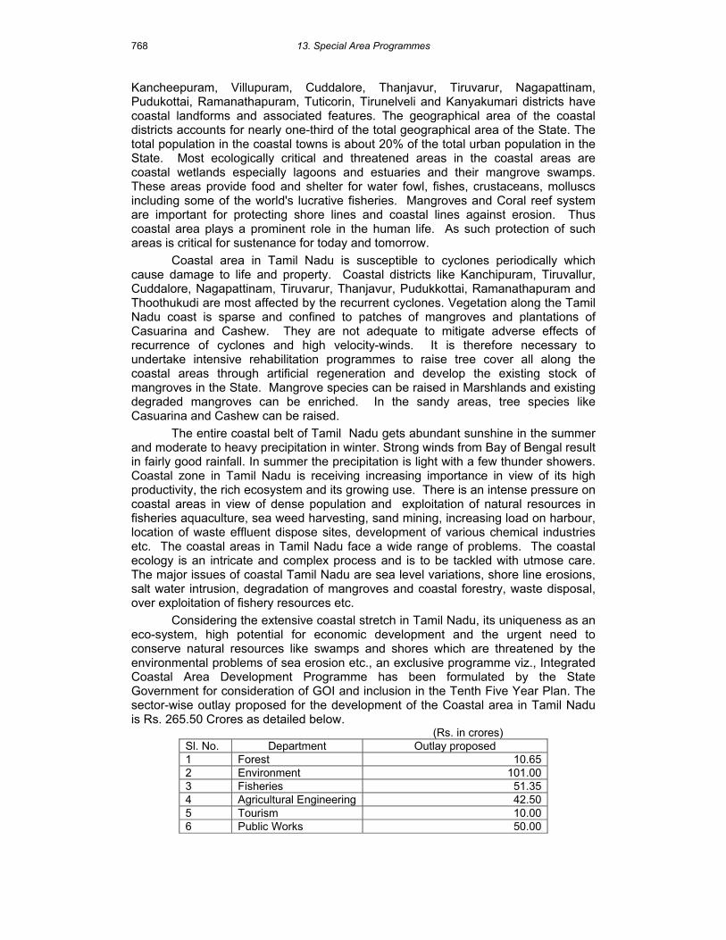
768
Kancheepuram, Villupuram, Cuddalore, Thanjavur, Tiruvarur, Nagapattinam, Pudukottai, Ramanathapuram, Tuticorin, Tirunelveli and Kanyakumari districts have coastal landforms and associated features. The geographical area of the coastal districts accounts for nearly one-third of the total geographical area of the State. The total population in the coastal towns is about 20% of the total urban population in the State. Most ecologically critical and threatened areas in the coastal areas are coastal wetlands especially lagoons and estuaries and their mangrove swamps. These areas provide food and shelter for water fowl, fishes, crustaceans, molluscs including some of the world's lucrative fisheries. Mangroves and Coral reef system are important for protecting shore lines and coastal lines against erosion. Thus coastal area plays a prominent role in the human life. As such protection of such areas is critical for sustenance for today and tomorrow.
Coastal area in Tamil Nadu is susceptible to cyclones periodically which cause damage to life and property. Coastal districts like Kanchipuram, Tiruvallur, Cuddalore, Nagapattinam, Tiruvarur, Thanjavur, Pudukkottai, Ramanathapuram and Thoothukudi are most affected by the recurrent cyclones. Vegetation along the Tamil Nadu coast is sparse and confined to patches of mangroves and plantations of Casuarina and Cashew. They are not adequate to mitigate adverse effects of recurrence of cyclones and high velocity-winds. It is therefore necessary to undertake intensive rehabilitation programmes to raise tree cover all along the coastal areas through artificial regeneration and develop the existing stock of mangroves in the State. Mangrove species can be raised in Marshlands and existing degraded mangroves can be enriched. In the sandy areas, tree species like Casuarina and Cashew can be raised.
The entire coastal belt of Tamil Nadu gets abundant sunshine in the summer and moderate to heavy precipitation in winter. Strong winds from Bay of Bengal result in fairly good rainfall. In summer the precipitation is light with a few thunder showers. Coastal zone in Tamil Nadu is receiving increasing importance in view of its high productivity, the rich ecosystem and its growing use. There is an intense pressure on coastal areas in view of dense population and exploitation of natural resources in fisheries aquaculture, sea weed harvesting, sand mining, increasing load on harbour, location of waste effluent dispose sites, development of various chemical industries etc. The coastal areas in Tamil Nadu face a wide range of problems. The coastal ecology is an intricate and complex process and is to be tackled with utmose care. The major issues of coastal Tamil Nadu are sea level variations, shore line erosions, salt water intrusion, degradation of mangroves and coastal forestry, waste disposal, over exploitation of fishery resources etc.
Considering the extensive coastal stretch in Tamil Nadu, its uniqueness as an eco-system, high potential for economic development and the urgent need to conserve natural resources like swamps and shores which are threatened by the environmental problems of sea erosion etc., an exclusive programme viz., Integrated Coastal Area Development Programme has been formulated by the State Government for consideration of GOI and inclusion in the Tenth Five Year Plan. The sector-wise outlay proposed for the development of the Coastal area in Tamil Nadu is Rs. 265.50 Crores as detailed below.
(Rs. in crores) Sl. No. Department Outlay proposed 1 Forest 10.65 2 Environment 101.00 3 Fisheries 51.35 4 Agricultural Engineering 42.50 5 Tourism 10.00 6 Public Works 50.00

13. Special Area Programmes
769
Department Total 265.50
The ICADP will be implemented by the State Government Departments of
Agricultural Engineering, Environment, Fisheries, Forests and Public Works Department besides eliciting participation of private industries, NGOs and Research Institutions operating in the coastal area. The schemes proposed for the development of the Coastal Area in Tamil Nadu are outlined below.
Conservation and regeneration of mangroves Mangroves provide forestry resources like firewood, timber, charcoal and
thatching material, which serve the needs of the community living around. The fishery resources in the mangrove estuaries and lagoons with adequate tidal water exchange are ideally suited for culture of crabs, clams, edible oysters, mussels and mullets. Mangrove ecosystems are undergoing widespread degradation due to a combination of physical, biological, anthropogenic and social factors. A variety of human-induced stresses such as changes in water quality, soil salinity and sedimentation due to diversion of fresh water in the upstream, conversion of mangrove wetlands for aquaculture, salt pans and other land use practices are largely responsible for reduction of mangrove vegetation. In Tamil Nadu, the mangroves are located in the districts of Tiruvellore, Chennai, Kancheepuram, Villuppuram, Cuddalore, Thanjavur, Nagappattinam, Pudukkottai, Tuticorin and Ramnad. There is vast scope still left for improving the existing degraded mangrove ecosystem by means of artificial regeneration in areas under the control of Forest Department and in common lands falling in the estuaries along the Tamil Nadu coast. In the plan period more attention will be given to improve, rehabilitate and protect the mangrove sites found occurring in common lands also. Therefore, it is proposed to tackle an extent of 1500 hectares in the mangrove areas under the control of forest Department and an extent of 500 hectares in the common lands. Local people who are interacting with these mangrove patches for their day-today life, will be fully involved in protection and regeneration works of mangroves in forest and common lands by duly forming the Village Forest Committees under JFM concept.
Entry Point Activities
Since the proposed plantation activities are confined to coastal areas, population living in coastal villages and in fishermen hamlets is dependent on these tree covers for grazing, cutting of firewood, fodder collection etc. Such biotic interference will have to be totally eliminated by creating alternate resources and awareness among the local people. In order to encourage local public to fully involve in the regeneration activity and protection of the existing tree cover, certain entry point activities are proposed to provide the basic amenities like drinking water supply, village hygiene, village link road and supply of tree seedlings for backyard planting etc. About 15% of the total project cost will be earmarked for this purpose. Publicity
Coastal ecosystem being very sensitive and fragile without the cooperation of the local public in particular and the visiting tourists to mangrove areas and other coastal pockets in general cannot be conserved effectively unless enough awareness is created and publicity is given. Visits of students from schools and colleges and scholars and scientists of research institutes will be encouraged by providing facilities like telescopes, motorized boats, rest sheds, interpretation centers etc. About 10% of the total project cost will be allocated for meeting the expenditure.
Shelter belts for conservation.

13. Special Area Programmes
770
Raising of coastal shelter belt along the coast of Tamil Nadu in forest lands, common lands and private lands has been done in the past. Shelter belts raised in forest land and common lands raised by the Forest Department could not achieve the desired success due to the biotic interference, while the Casuarina plantations raised by the private owners for their commercial use could produce success to some extent only. Hence it has been proposed to create shelter belt along the coast of Tamil Nadu, which would act as the first line defence against the effect of frequent cyclonic storms and heavy winds.
Department of Environment
The Department of Environment is involved in the coastal zone management and implementation of Coastal Regulation Zone Notification 1991. It is proposed to undertake the following activities:
1. Integrated Coastal Zone Management Plan is required for planned development of the coast. A perspective plan on ICZM will be prepared involving experts and stakeholders.
2. Abatement of coastal pollution by providing I&D and STP in selected coastal towns viz., Thoothukudi, Cuddalore, Nagapattinam, Kanyakumari and Sirkali.
3. The publicity and awareness is an integral part of coastal development. Provision has been made for publicity, awareness programmes to manage the coast in an ecologically sustainable manner.
4. Local bodies will be involved in the implementation of Low Cost Sanitation. Local bodies will be responsible to take effective action to subscribe to the standards prescribed.
5. Scientific monitoring of coastal pollution will also be undertaken by Directorate of Environment
Arresting coastal pollution and eco-restoration of waterways/water bodies will be undertaken by Directorate of Environment.
Prevention of raw sewage entering the sea/coastal estuaries in selected major towns viz., Cuddalore, Nagapattinam, Thoothukudi and Kanyakumari will be undertaken with assistance of Ministry of Environment and Forests, Government of India and participation of State Government and local bodies and public contribution.
Fisheries Department
Fisheries Development Programme will aim at improving the socio economic condition of the fishermen as well as augmenting fisheries resources. Scientific aquaculture will be promoted outside CRZ. Value addition such as crab fattening, lobster fattening and seaweed culture will be promoted. Fishermen welfare will be given top priority. Tamil Nadu is endowed with the second largest coastline of 1076 km. It has a continental shelf of 41,412 km2 and EEZ of 0.19 million km2. There are 591 marine fishing villages along the Tamil Nadu coast with a total fishermen population of 6.80 lakhs of which 2.7 lakhs are actively engaged in fishing activities. The coastal areas and inshore waters offer vast potential for development of fisheries. Over the last four decades, the marine fishery policy of Tamil Nadu has been focused on the exploitation of resources in the inshore waters. As a result, production increased from 0.46 lakh tonnes in 1951-52 to 3.67 lakhs tonnes in 2000-2001. If the efforts/investments on capture fisheries is allowed to be increased without augmenting and conserving natural resources, there is every possibility of depletion of natural resources. Taking note of this, the State's Policy presently aims at

13. Special Area Programmes
771
management, conservation and exploitation of fisheries resources in the coastal areas in a sustainable manner.
In Tamil Nadu, apart from shrimp aquaculture, the other mariculture activities like marine fin fish culture, cage culture, pen culture, molluscan culture are yet to be developed.
Strategy for development of fisheries in the coastal areas
1. To increase the catch per unit in the inshore areas, stock enhancement/sea ranching programme must be charted out by providing necessary infrastructure facilities.
2. For effective implementation of conservation measures, the critical areas may be identified and declared fish sanctuary, closed season and marine national park, etc. While implementing the conservation measures, the likelihood security of the coastal fisherfolk should be duly taken care of.
3. As the aquaculture industry is the last frontier for food security to the growing population, promoting sustainable eco friendly coastal aquaculture along the coast is of utmost importance.
4. Master Plan for developing the mariculture activities like marine finfish culture, cage culture, pen culture, molluscan culture along the coast is of utmost importance. The potential of these resources are hitherto unexploited.
5. Similarly, value addition through crab fattening and lobster fattening will also be promoted.
I. Development of Marine Fisheries
Details of schemes implemented by Department of Fisheries are given in the chapter on Fisheries.
1) Sea Ranching
A scheme is proposed for the improvement of the marine fish stocks by resorting to ranching of seeds artificially produced in the hatcheries
2) FRP Catamaran
In view of Scarcity of Albizia woods for the construction of catamaran force, the fishermen to go for an alternative material for the construction of catamaran. The suitable alternative is FRP catamaran to replace the existing wooden catamaran. It has been proposed to distribute 1000 FRP catamarans to the traditional fishermen.
3) Diversified off-shore fishing
The existing two Exploratory Fisheries Station will be equipped with suitable infrastructure for effective demonstration of diversified fishing methods such as long lining, gillnetting and trolling to the fishermen as an alternative for trawling
4) Artificial Reefs
A scheme is proposed for provision of artificial reefs in 10 places.
II. Fishermen Welfare
1) Fishermen Free Housing Scheme
Construction of free houses and repairs to the houses of fishermen living in huts in coastal villages.
2) Motorisation of traditional crafts

13. Special Area Programmes
772
The scheme is to motorise the traditional crafts with OBM/IBM to enable the fishermen to have an opportunity to cover more fishing grounds and reach shore with fresh catches. The traditional fishermen are also given financial assistance for the purchase of fishing nets under the scheme. It is proposed to distribute engines and nets to the traditional fishermen.
3) Reimbursement of Central Excise Duty on HSD oil
To alleviate the suffering of the mechanized fishing boat operators the Government reimburse the Excise Duty as subsidy for the purchase of HSD Oil to bring down the Running cost of machanised fishing boats. This scheme will be continued during the Tenth Five Year Plan period.
III. Mariculture
1) Establishment of marine fin fish hatchery for seabass and grouper
Seed availability of seabass and grouper is a major constraint for development of marine finfish culture. Further seabass and groupers are species that could be cultured in brackishwater ponds. Since shrimp farming is threatened with viral diseases, these species could be cultured in farms approved by Aquaculture Authority and farms located outside CRZ.
IV. Brackishwater Aquaculture
The following scheme will be taken up for the Integrated Management of Pulicat Lake Ecosystem.
a) Construction of shrimp hatchery for production of shrimp seeds b) Establishment of Ranching centres for rearing the seeds in Pens, ponds,
embankments and to stock the seeds in lake c) Establishment of Artificial reef and Fish Aggregating Devices (FAD) off the
bar mouth to facilitate natural recruitment d) Mud crab hatchery e) Mangrove Reforestation for habitat rehabilitation f) Oyster Bed Development, Oyster culture in specified areas for water quality
improvement g) Fishing Regulation and Resources conflict
Agricultural Engineering
The chapter on Soil and Water Conservation may also be referred to.
Preventing Soil Erosion due to wind, sand dune stabilization and salinity Sand dunes formed in the coasts of Nagapattinam, Thoothukudi, Pudukkottai, Cuddalore, Kancheepuram will be a thrust area. The problem of soil erosion is heavy in coastal Nagapattinam, Ramanathapuram, Tirunelveli and Thoothukudi Districts. It is proposed to cover 5000 ha. per annum in five districts with sand dune control measures like raising shelter belts, legumes to stabilize sand dunes with construction of shallow wells or farm ponds to give life saving irrigation for the coastal plantations. It is proposed to take up this work in 25000 ha. area in X Plan at 5000 ha per annum in the four districts. The works like deepening of ponds and construction of water harvesting structures will also be taken up in these areas. This will protect the lands from sea water intrusion as the surface water from the high rainfall in the coastal zones are stored in these ponds. The work of sand dune stabilization in each block will be carried out through Agricultural Engineering and Forest Department.

13. Special Area Programmes
773
Protection of area where ground water is affected by sea water - The coastal aquifers in Tiruvallur, Kancheepuram, Villupuram and Cuddalore District are affected by sea water intrusion. It is proposed to take up ground water recharging works with water harvesting structures and injunction wells and having three dimensional GIS of coastal aquifer zones to reclaim the affected lands and protect the lands from sea water intrusion. It is proposed to implement the scheme in 4 districts covering 10000 ha in X Plan at 2000 ha per annum.
Tourism Department
Tourism is an important activity along the coast. Government of India has already declared Chennai to Pondicherry coast as special tourism promotion Zone. There are number of tourist spots along this area starting with Pulicat Lake, Muttukadu, Mahabalipuram, Sadhurangapattinam, Manora. Beach tourism, water sports have been developed in this area. Besides this, heritage tourism along Mahabalipuram, Alambara Fort, Tiruchendur, Rameswaram, Chidambaram will be undertaken. International water sports camps will be conducted in Muttukadu and Idaikalinadu like Pattaya in Bangkok. Adventure tourism and eco tourism will be promoted in the Gulf of Mannar Biosphere Reserve especially Nallathanni Theevu and Muyal Theevu. Nagapattinam coast could be developed as special tourism area where there are several places of religious significance like Thirunallar, Velankanni and Nagore. While Tourism Department and Tourism Development Corporation can improve the infrastructure facilities in these tourist spots, private entrepreneurs will be invited to develop beach resorts and facilities for boarding and lodging of tourists. Provision for development of infrastructure facilities to attract tourists among India and abroad is made as a part of Integrated Coastal Zone Development Programme.
Public Works Department
Public Works Department is implementing provision of coastal defences to prevent sea erosion. An anti-sea erosion division of Public Works Department was functioning earlier in Kanyakumari. The vulnerable stretches of coast such as Royapuram, Tiruvottiyur, Kanyakumari will be provided with anti-sea erosion measures. Similarly river mouths of Cooum and Adyar will be kept open through construction of groynes.
Integrated Sea Water Farming for Coastal Area Prosperity Globally 97% of water is sea water. Tamil Nadu has a shoreline of 1000 kms.
Nearly 20% of the State's population lives within 60 kms from the shoreline. Therefore harnessing seawater must form an integral part of the total water security system. Seawater can be used for promoting agro-aqua farm along the coast for the prosperity of coastal communities and also for protecting the coastal ecosystem from the impending rise in the sea level due to climate change. The following statement from UNESCO underlines the potential and need for harnessing sea water: "Mankind must understand at this point in its development that its future relies as much as on an intelligent use of ocean water as it does today on rainwater (1998)”.
A seawater farm is a farm that use clean untreated seawater to raise its crops instead of freshwater. This symbolizes second invention of agriculture, this time, based on almost infinite supply of water that resides in the world's ocean. An integrated seawater farm is a farm that combines the growing of salt tolerant field and orchard crops with the husbandry of animals, mainly shrimp and fish.
The field and orchard crops that can be grown by seawater irrigation belong to two groups of plants namely, a) halophytes and b) mangroves. Halophytes grow only in saline water and they occur over a wide variety of salinity. The halophyte database HALOPH contain 1560 species, many of which can be grown in the

13. Special Area Programmes
774
seawater farm as a) Cash crops to produce edible oils, vegetables, medicinal plants and flowers b) Fodder for cattle, sheep, goats, feed for fish and wild life c) Raw material to produce various fine chemicals and new products d) Producer of lumber and building materials e) Producer of biofuels and f) Planting materials for rehabilitation of degraded coastal areas. Similarly, mangrove species which grow only in coastal saline areas, can be grown along with the halophytes to produce timber, poles, building materials, honey, fodder and firewood. More importantly, mangroves grown in seawater farm can be utilised to enhance capture fisheries of adjacent coastal water. It is estimated that for every hectare of mangroves grown, fish catch is increased by about 1.08 tones per hectare per year.
The other component of the Integrated Seawater based agri-aquaculture system is farming of shrimp and fish. Other activities of economic value that can be combined are culture of Artemina, Tilapia, seabass, crab fattening and sea ranching. Extensive system of aquaculture or low External Input Sustaintable Aquaculture System can be easily integrated with halophyte and mangrove crops.
Examples of successful Seawater farming - A few regions in Europe, USA and Mexico grow halophytes as vegetables with seawater irrigation. Saudi Arabia has recently started an ambitious plan of developing 200000 ha of seawater irrigation farms to produce 120 million kg of high-quality vegetable oil for human consumption. However, seawater farming started in Eritrea, a small country north of Ethiopia with vast coastal deserts, provides the best example of sea water farming which can be effectively utilised as mechanism to alleviate poverty among coastal rural poor. In the Eritrea Seawater Farm, shrimps are grown in a series of ponds, as a first tier near the sea and nutritional excretion from the shrimps are then taken to a second series of basins where Tilapia fish are bred and finally onto a third series of basins where Salicornia are grown. The water from the Salicornia farms is finally drained into artificially created wetlands where millions of mangrove trees have been planted. These mangrove trees along with Salicornia changed the desert coast of Eritrea into green forest.
Initiation of seawater farming in Tamil Nadu
The total estimated brackish water area of Tamil Nadu coast of 1076 km is about 56000 ha. Apart from mangrove wetlands in Pichavarm and Muthupet, Point Calimer Sanctuary near Vedaranyam and Pulicat lake near Chennai, most of the brackish water area, especially mudflats and saline affected sandy areas, remain barren or with limited biological productivity. Some of these areas are being utilised for salt production and limited area for prawn culture and vast barren coastal areas are still available to initiate Integrated Seawater Farming.
The initiation of integrated sea water farming programmes need the following support:
Public Policy Support – in allotment of poramboke land to the poor (fisher-women and other weaker sections of society etc). Land can also be made available on lease to groups of poor families for cooperative farming or Self Help Groups.
Package of Technology - seawater farming by poor need to be supported by technological innovation. A consortium of State, Central Departments, Research Institutes and private institutions could be formed.
Community Led Management - Success of Integrated Seawater Farming initiative is very much dependent on the active participation of the local communities from planning stage itself. This could be achieved by organising SHGs in the participating village or other socially acceptable forms such as Village Councils.

13. Special Area Programmes
775