11 - confex
TRANSCRIPT

1. INTRODUCTION To support its pioneering work in storm-scale numerical weather prediction, the Center for Analysis and Prediction of Storms (CAPS) at the University of Oklahoma (OU) launched the Collaborative Radar Acquisition Field Test (CRAFT) in Fall 1998 (Droegemeier et al., 2002). A multi-institutional initiative involved the National Oceanic and Atmospheric Administration (NOAA), National Severe Storms Laboratory (NSSL), the University Corporation for Atmospheric Research (UCAR) Unidata Program, the NOAA next-generation radar (NEXRAD) Radar Operations Center (ROC), the University of Washington, and the NOAA National Climatic Data Center (NCDC). CRAFT successfully demonstrated the capability of compressing, and transmitting in real time via the Internet, WSR-88D Level-II data from multiple radars throughout the continental United States. By Summer 2003, more than 60 NEXRAD radars were participating, with data distributed in real time by CAPS to more than 40 institutions including universities, government organizations, and private companies. CRAFT became one of the most successful engagements of the private weather enterprise in a public/private partnership. The award-winning CRAFT project led to a major redesign of data ingest and distribution services at the NCDC, replacing unreliable and expensive 8 mm tape technology (DelGreco and Hall 2003). OU initiated and successfully led Project CRAFT for over five years. In light of its rapidly expanding research programs in weather radar and a continuing need for Level-II data for numerical weather prediction, as well as decision support system development, OU sought and obtained approval in December 2003 from NOAA to become a top-tier Level-II data acquisition and redistribution node within the new Abilene-based operational data delivery infrastructure. Similar top-tier nodes were approved by NOAA for Purdue University and the Education and Research Consortium of the Western Carolinas, Inc. CRAFT proved the concept that advanced university-only (i.e., Abilene) networking technologies could be harnessed to rapidly concentrate valuable weather data. Once concentrated, the data then can
† Corresponding Author Address: Prof. Kelvin K. Droegemeier, 100 East Boyd Street, Suite 1110, Norman, OK 73019. Email: [email protected]
be shared (via commercial Internet) for research, government, and private concerns. Per terms of the memorandum of agreement, Integrated Radar Data Services (IRaDS) was developed at OU to transition CRAFT research successes into an operational program that can serve weather commerce. As a program of CAPS at OU, IRaDS was developed as a service recharge center that provides real-time level-II radar data for the cost of provision. Since beginning operation in April 2004, IRaDS is proving itself as an essential mechanism for NOAA to share data via outsourced provisioning through the university environment. By April 2004, the original CRAFT network had expanded to an operational IRaDS service with 124 WSR-88D site data feeds, mostly via NWS regional data servers. CRAFT pioneering technology is consistently achieving targets of data delivery from source radars to a user server with as little as ten seconds latency. The IRaDS program model tracks closely with the OU mission, which is to provide the best possible educational experience for its students through excellence in teaching, research and creative activity, and service to the State and society. By first creating concentrated high-resolution radar data that adds vitality to weather research, IRaDS serves the State and society by enabling weather commerce with data (as a raw material) to create a new generation of products and services. Such private growth also leverages legacy research and pushes requirements for future research. IRaDS further serves society by helping weather experts in all sectors generate improved weather awareness information for operations efficiency and resource protection. We describe in this paper the continuing evolution of the original motivation that carried Project CRAFT as well as the IRaDS program strategy that shows great potential as a model for public/private cooperation. Additionally, we discuss opportunities for further development of the IRaDS program model—including incorporation of other surveillance radar systems and especially those operated by the Federal Aviation Administration (FAA), as well as a new generation of experimental radars and even operational numerical model output. 2. PROGRAM MISSION, VISION, AND GOALS The IRaDS program model and associated processes evolved from the CRAFT research project to provide nonexclusive service to all private sector and government participants. Great care was taken to
11.3
AN INTERNET-BASED TOP-TIER SERVICE FOR THE DISTRIBUTION OF STREAMING NEXRAD LEVEL-II DATA: CRAFT BECOMES AN OPERATIONAL SYSTEM
†x1,2Kelvin K. Droegemeier, 3Joel D. Martin, 3Carl Sinclair, and 1Scott D. Hill
1Center for Analysis and Prediction of Storms, 2School of Meteorology, 3Integrated Radar Data Services
University of Oklahoma Norman, OK 73019

support nondisclosure practices so that private enterprises could protect their internal strategy and competitive interests while harvesting valuable data from the university program. 2.1 Program Mission The mission of IRaDS is to provide a low-latency, reliable, and economical data service that supports research, enables commerce, and serves society with improved weather awareness information. 2.2. Program Vision The IRaDS vision calls for replicating the success of the initial NEXRAD provisioning service for other data, as needs are identified, evolving a comprehensive weather data portal that enhances research and provides basic raw materials for expanding weather commerce. The program mission and vision place the scope of IRaDS in the midst of a delicate balance between public and private sector roles within society. Realizing the issues, IRaDS has focused from the start on unique university capabilities in the provisioning of data as a raw material that can enable the private sector to produce advanced products and services. Universities have access to specialized networking and information technologies (e.g., Abilene) that can concentrate data for research and development. Universities also maintain a labor pool of students with specialized expertise—an environment highly compatible with cost-effective continuous data monitoring for a top-tier data provisioning service. 2.3 Program Goals The IRaDS program set five goals for operations and sustainment:
• Maintain personal and professional integrity—add a genuine personal touch in all IRaDS activities.
• Educate the weather community on the value of NEXRAD (WSR-88D) Level-II (base) data.
• Build a targeted, refined marketing database that depicts potential users of IRaDS products.
• Define products and pricing for research, government, and private sector requirements.
• Establish solid accounting practices and a sales pace for cost recovery and program sustainment after the first year.
Several key practices have helped ensure that these goals are met or exceeded during the first year of program execution. OU senior leaders elected to invest in experienced executive management to stabilize the program from the start and add the kind of operational performance expected by industry. This effort was aided by also leveraging technical leadership from Project CRAFT to form the nucleus of the IRaDS management team. Senior leadership avoided shortcuts in technical personnel and equipment needs to maximize data reliability for the portion of the provisioning that is
under direct control of OU. The up-front investment was coupled with sound accounting practices to assure cost recovery and maximum value to the end users of the provisioning service. OU leaders also realized the primary weather vendor market is relatively small and thus developed forms of value-added reseller relations and agreements to collaborate with the technology vendors and more effectively reach the end-user market for weather awareness information. The IRaDS team developed a robust, personalized, and highly targeted marketing process that focuses on generating genuine long-term relations. The IRaDS team realized that a fast, reliable data service is the bottom line key to the program's success. IRaDS employed technically sound graduate research assistants and other part-time employees to provide jobs and assist the education environment while optimizing labor costs for the operation. This expertise is working to create a first response and true partnership with NOAA and NWS to quickly identify and resolve data issues. Finally, IRaDS is using sound client relations to jointly look for opportunities to diversify data offerings and create the raw materials weather commerce needs for stability and future growth. IRaDS is meeting the challenge of specific technical goals for the program. The original Unidata Call for Participation document, prepared in collaboration with the NWS, listed a number of minimum requirements that had to be met by top-tier data nodes. Infrastructure investments and the technical strategy discussed previously have led OU to meeting or exceeding these goals:
• Receive and relay data from all 132 and possible expansion to over 140 participating radars
• Knowledge of Level-II data format and use • At least an Internet2 connection • Capability for large product queue (> 2 GB)
support in LDM • Bandwidth to deal with projected volume of
data by year 2005; minimum incoming bandwidth=80 Mb/second; minimum outgoing bandwidth=400 Mb/second (based on four downstream sites)
• Access to commodity Internet to serve the private sector
• 24x7 operations support highly desired, but not required
• UPS/power generation facilities and redundant disk arrays (RAID systems)
• Willingness to upgrade equipment if necessary
• Use of Unidata supported or approved platforms
• Willingness to upgrade LDM software when needed
• Staffed by Unidata workshop trained professionals or those with strong working knowledge of LDM software
• Working knowledge of Unix or one of its variants such as Linux
• Over 95% data distribution reliability, uptime, and availability
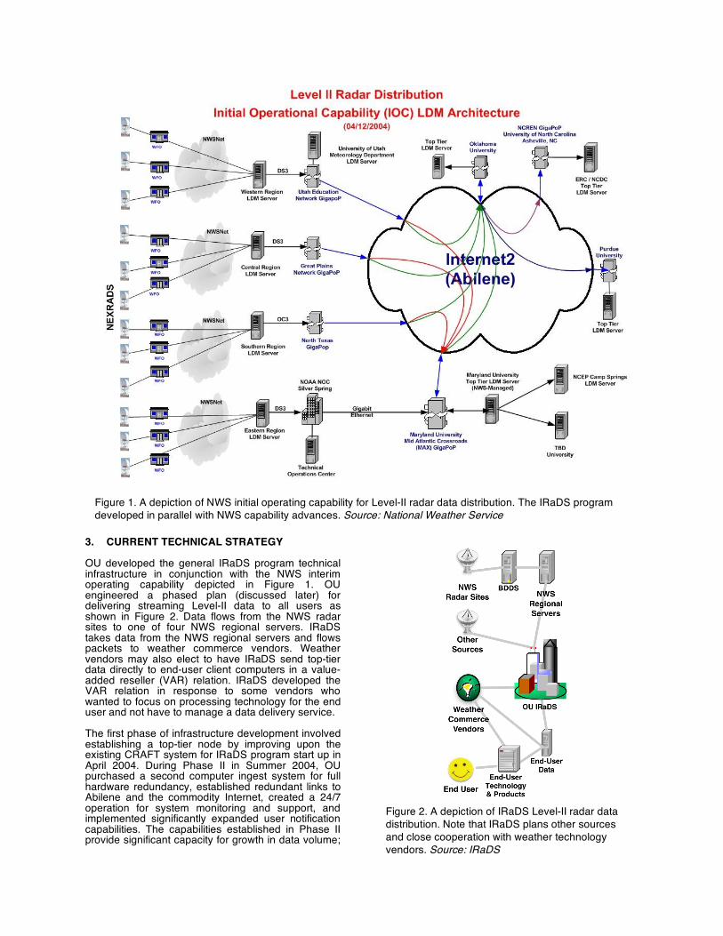
3. CURRENT TECHNICAL STRATEGY OU developed the general IRaDS program technical infrastructure in conjunction with the NWS interim operating capability depicted in Figure 1. OU engineered a phased plan (discussed later) for delivering streaming Level-II data to all users as shown in Figure 2. Data flows from the NWS radar sites to one of four NWS regional servers. IRaDS takes data from the NWS regional servers and flows packets to weather commerce vendors. Weather vendors may also elect to have IRaDS send top-tier data directly to end-user client computers in a value-added reseller (VAR) relation. IRaDS developed the VAR relation in response to some vendors who wanted to focus on processing technology for the end user and not have to manage a data delivery service. The first phase of infrastructure development involved establishing a top-tier node by improving upon the existing CRAFT system for IRaDS program start up in April 2004. During Phase II in Summer 2004, OU purchased a second computer ingest system for full hardware redundancy, established redundant links to Abilene and the commodity Internet, created a 24/7 operation for system monitoring and support, and implemented significantly expanded user notification capabilities. The capabilities established in Phase II provide significant capacity for growth in data volume;
Figure 1. A depiction of NWS initial operating capability for Level-II radar data distribution. The IRaDS program developed in parallel with NWS capability advances. Source: National Weather Service
Figure 2. A depiction of IRaDS Level-II radar data distribution. Note that IRaDS plans other sources and close cooperation with weather technology vendors. Source: IRaDS

e.g., to accommodate dual polarization NEXRAD data (Crum et al. 2005), as well as operational levels of reliability. Figure 3 shows the networking configuration of the IRaDS Level-II ingest and distribution system now in operation at OU. The IRaDS Operations Center (see later discussion regarding the associated computer equipment), located in the Sarkeys Energy Center on OU’s Main Campus (dashed box at bottom of figure), is connected to the campus Information Technology (IT) system routers via gigabit Ethernet. The OU Norman campus as a whole is linked to OneNet (Oklahoma’s telecommunications infrastructure) in Oklahoma City via an OC-3 SONET ring and an independent gigabit Ethernet circuit. The OneNet hub provides connectivity to Abilene via an OC-12 fibre circuit to the Abilene gigabit point of presence
(gigapop) in Kansas City, and to the commodity Internet via three independent fibre-optic circuits at OC-12 capacity. At the present time, OU is receiving Level-II data from each of the NWS Regional Headquarters servers via the new NWS transmission infrastructure (which includes Abilene; and OU distributes these data to academic and government users via Abilene (see Figure 1), and to the private sector via the commodity Internet, with greater than 95% reliability (as measured by the NCDC). Figure 4 details the computer system now being used to ingest and distribute Level-II data at OU. It consists of a 10-node, dual-processor (20 processors total) fully dedicated IBM Pentium III (1.26 GHz) cluster with 1 gigabit/sec interconnects and system uplinks. Eight of the nodes (16 processors) are dedicated to data ingest, while two others are dedicated to storage and
Gigabit Ethernet
OC-3 SONET Ring (155 mbits/sec)
Plus Independent Gigabit Ethernet
OC-12
(622 mbits/sec)
Three Independent OC-12
(622 mbits/sec)
Various
Abilene
Gigapop
(Kansas City)
Figure 3. Network topology of the current IRaDS Level-II data ingest system at OU. CRAFT was the research project name. IRaDS is the operational program name. Source: IRaDS

monitoring/system management (failure of the latter does not impact data distribution to external users). The data ingest nodes each contain 2 gigabytes of memory, SCSI hot swap drives, and redundant power supplies. If any node fails, the radar feed coming into it automatically reverts to another node. The storage node is similarly configured, but with 2.5 terabytes of hot-swap RAID 5 storage with independent RAID 1 mirroring for the operating system drives. The cluster is sited within an environmentally controlled and physically secure machine room (conditioned power, dual uninterruptible power supply, triple redundant HVAC units) and is linked directly to the gigabit Ethernet campus backbone via a Cisco router.
Phase II began in Summer 2004 and represents the major transition to full 24/7 operations designed to provide operational reliability, significantly expanded monitoring and user notification services, and the ability to accommodate significant increases in data volume. Specifically, OU is completing the following tasks during Phase II (see figures and text that follow):
• Purchasing a new computer cluster to serve as the primary Level-II ingest and distribution system, with the existing system (Figure 4) serving as a back up. The new system has the ability to deliver streaming Level-II data from over 200 radar feeds to 100 customers including academia (e.g., Unidata) and the Federal government, with latencies of 10 sec
or less from the radar site to the client's server. The system also will be fully scalable to accommodate significant increases in data volume, number of users, and types of data to be transmitted.
• Eliminating all single points of failure under
OU control (i.e., excluding the communication and computer systems operated by the NWS) by installing redundant network links to Abilene and the commodity Internet.
• Expanding real-time data monitoring and user notification capabilities. Full 24x7 monitoring service began in April 2004.
• Moving the Level-II primary operations center from Sarkeys Energy Center to the OU Research Campus-South. This facility will provide emergency diesel backup power, a state-of-the-art machine room, redundant cooling, conditioned power and chilled water facilities from a new $6M physical plant now under construction, and a large uninterruptible power supply.
• Establishing full client support service with a custom web interface for clients and human data monitors and technical consultants available 7x24 via email and a toll-free hotline.
The new dedicated computer that serves as the primary data ingest and distribution system for Phase II is much like the system shown in Figure 4. Like its predecessor, which now functions as a back-up, it consists of a cluster of independent, fully redundant multi-processor nodes, with each of the NWS Regional Headquarter servers feeding two separate nodes. A dual-redundant gigabit Ethernet link ensures fault tolerance to external communications resources, and sufficient RAID storage is available for holding several weeks of Level-II data. As noted above, the primary system cluster is located within a state-of-the-art machine room within the Stephenson Research and Technology Center, which is linked to the new physical plant (described previously). This system is fully scalable (within the rack or across new racks), and will be automatically redundant with the secondary system physically separated in the Sarkeys Energy Center. 4. SYSTEM PERFORMANCE IRaDS has been in operation since April 2004. Systematic performance data have been collected since then and now are being analyzed as more of the full NWS infrastructure comes on line. Figure 5 depicts the full operational capability envisioned by NWS. IRaDS provided NEXRAD Level-II data to the National Hurricane Center (NHC) during the 2004 season. A future study by Martin and Sinclair will examine Level-II system performance as experienced by the NHC client server during 2004 land-falling hurricanes. Preliminary results show that latency figures from each radar site to the NHC server were much better than the ten-second target and often were below five seconds for the key radar sites. NWS did experience sporadic communications outages for only a few sites when Internet service provider infrastructure was damaged by the hurricanes. IRaDS equipment and
Figure 4. Computer system at OU now being used to ingest and distribute Level-II data for IRaDS. Source: IRaDS

network reliability was at 100% during the hurricanes and able to deliver all data provided by the NWS sites. Since program inception, IRaDS experienced three days of latency problems in May 2004 caused by dropped packets, which were found to be created by bandwidth restrictions imposed by an Internet service provider. Otherwise, IRaDS has maintained full 24/7 service and has delivered all data made available by the NWS infrastructure. The NWS has continued to transition the Level-II network to the desired end-state infrastructure (Crum et al. 2003). 5. SUMMARY AND FUTURE VISION IRaDS is a program of The University of Oklahoma developed as a top-tier provider of NEXRAD Level-II data for the cost of provision. The program thus far has proven that advanced networking technologies available exclusively to the academic community (Abilene) can be harnessed to efficiently and reliably concentrate valuable weather data for research and development. Once concentrated, the data also can be provisioned (via standard Internet) for sharing with other research, government, and private interests. The memorandum of agreement, signed between OU
and the National Oceanic and Atmospheric Administration (NOAA) in April 2004, codified creation of IRaDS as a top-tier provider and an essential mechanism for NOAA to share data via outsourced provisioning through the university environment. We see this nascent relationship as a promising model for future university, public, and private sector relations. Further evolution of the concept points to evolving a comprehensive weather data portal that enhances research and weather commerce using IRaDS program model. The concept of replicating the basic IRaDS model to a comprehensive data portal involves identifying new data needs and creating new "channels" of data provisioning including but not limited to the following:
• NSSL Phased Array Radar Test Bed (SPY-1 technology), which is a prototype being developed as the follow-on to NEXRAD;
• Prototype dual-polarization NEXRAD radar (KOUN), which is located on the OU Research Campus (dual-polarization capability is expected to become operational within NEXRAD nationwide by early 2008);
• Oklahoma test bed (9-12 radars) of the new
Figure 5. A depiction of the planned NWS full operating capability for Level-II radar data distribution. The IRaDS program continues to evolve in parallel with NWS capability advances. Source: National Weather Service

NSF Engineering Research Center for Collaborative Adaptive Sensing of the Atmosphere (CASA), which is developing inexpensive, low-power phased array Doppler radars for cell phone towers as a means of sampling the lower atmosphere at high temporal and spatial resolution;
• FAA Terminal Doppler Weather Radar (TDWR), Air Surveillance Radar (ASR) and Air Route Surveillance Radar (ARSR), which combined represent some 150 radars that provide Doppler weather data (Weber, 2004) ; and
• TV-station Doppler weather radars throughout the United States.
Coupled with a new 5-year NSF Large Information Technology Research (ITR) grant, Oklahoma’s vision is to develop IRaDS as a National Weather Radar Data Portal that provides streaming and archived radar and associated in situ data, as well as mining and assimilation capabilities, to all users. IRaDS is an important component of this effort, which is envisioned to bring enormous capabilities to the research, operations, and industrial communities. IRaDS serves society by enabling weather commerce with data as a raw material to create a new generation of products and services. Such private growth also leverages legacy research and pushes more research requirements. Top-tier data portals help weather experts generate improved weather information for operations efficiency and resource protection. By the start of 2005, after seven months of operation, IRaDS will have approximately a dozen contract customers and is embarking on new value-added reseller (VAR) master agreements with several new clients, as mentioned previously. The VAR concept is worth highlighting because it allows weather technology vendors to obtain and pipe an IRaDS top-tier data feed directly to their end user environment. The private-sector vendor supplies processing technology and final solution tools for the end user while leveraging IRaDS as a stable 24x7 source for the raw data needed to create the products and services. The VAR concept reduces latency and complexity for the weather technology vendor and provides a seamless solution of data and technology—university and private-sector collaboration that is transparent to the end user. 6. ACKNOWLEDGMENT The authors gratefully acknowledge the support of Linda Miller, Kevin Kelleher, Jason Levit, Russ Rew, Woody Roberts, Guy Almes, Lora Wilson, Jim Belville, Jack Hayes, Walt Telesetsky, Bob Saffle, Warren Blanchard, Esther Atkins, and Greg Mandt. The advocacy of improved access to WSR-88D data by the US Weather Research Program Science Steering Committee and, in particular, by Rit Carbone and Bob Gall, is gratefully acknowledged. This research was supported by the National Science Foundation under Grant ATM91-20009 to CAPS, and by Grant ATM99-81130 to the first author. Additional support was provided to CAPS and the NSSL by NOAA through Cooperative Agreement NA67RJ0150, which involves funding from the NOAA ESDIM
(Environmental Service Data and Information Management) and HPCC (High Performance Computing and Communications) Programs, and by several private companies that worked in partnership to make CRAFT a success. 7. REFERENCES Crum, T., C. Gilbert, S. Smith, and J. Heimer, 2005:
An Update on the NWS Implementation of the WSR-88D Level II Data Collection and Distribution Network. Preprints, 21st Int. Conf. on Interactive Information Processing Systems (IIPS) for Meteorology, Oceanography, and Hydrology, 9-13 January, Amer. Meteor. Soc., San Diego, CA.
Crum, T., D. Evancho, C. Horvat, M. Istok, and W. Blanchard, 2003: An update on NEXRAD program plans for collecting and distributing WSR-88D base data in near real time. Preprints, 19th Int. Conf. on Interactive Information Processing Systems (IIPS) for Meteorology, Oceanography, and Hydrology, 8-13 February, Amer. Meteor. Soc., Long Beach, CA.
Crum, T.D., R.E. Saffle, and J.W. Wilson, 1998: An update on the NEXRAD program and future WSR-88D support to operations. Wea. Forecasting, 13, 253-262.
Crum, T. D. and R. L. Alberty, 1993: The WSR-88D and the WSR-88D Operational Support Facility. Bull. Amer. Meteor. Soc., 74, 1669-1687.
Crum, T.D., R.L. Alberty, and D.W. Burgess, 1993: Recording, archiving, and using WSR-88D data. Bull. Amer. Meteor. Soc., 74, 645-653.
Del Greco, S. and A. Hall, 2003: NCDC the "One Stop Shop" for all WSR-88D Level-II Data Services. Preprints, 19th Int. Conf. on Interactive Information Processing Systems (IIPS) for Meteorology, Oceanography, and Hydrology, Long Beach, CA, Amer. Meteor. Soc.
Droegemeier, K.K., K. Kelleher, T. Crum, J.J. Levit, S.A. Del Greco, L. Miller, C. Sinclair, M. Benner, D.W. Fulker, and H. Edmon, 2002: Project CRAFT: A test bed for demonstrating the real time acquisition and archival of WSR-88D Level-II data. Preprints, 18th Int. Conf. on Interactive Information Processing Systems (IIPS) for Meteorology, Oceanography, and Hydrology, 13-17 January, Amer. Meteor. Soc., Orlando, Florida, 136-139.
Droegemeier, K.K. and Co-Authors, 2000: Hydrological aspects of weather prediction and flood warnings: Report of the Ninth Prospectus Development Team of the U.S. Weather Research Program. Bull. Amer. Meteor. Soc., 81, 2665-2680.
Droegemeier, K.K., 1997: The numerical prediction of thunderstorms: Challenges, potential benefits, and results from realtime operational tests. WMO Bulletin, 46, 324-336.
Foufoula-Georgiou, E. and W. Krajewski, 1995: Recent advances in rainfall modeling, estimation, and forecasting. Rev. Geophys., 33 (Suppl.), 1125-1138.
Fritsch, J.M. and Coauthors, 1998: Quantitative precipitation forecasting: Report of The Prospectus Development Team, U.S. Weather Research Program. Bull. Amer. Meteor. Soc., 79, 285-299.
Gauthreaux, S.A. Jr. and C.G. Belser, 1998: Displays of bird movements on the WSR-88D: Patterns and quantification. Wea. Forecasting, 13, 453-464.
Lilly, D.K., 1991: Numerical prediction of thunderstorms -- has its time come? Quart. J. Roy. Meteor. Soc., 116, 779-798.
NRC, 1999: Enhancing access to NEXRAD data -- A critical national resource. National Academy Press, Washington, DC, 16pp.
Weber, M.E., 2000: FAA Surveillance Radar Data as a Complement to the WSR-88D Network. 20th Conference on Severe Local Storms, Orlando, Florida.