109367 final report 130426 - south gippsland shire
TRANSCRIPT

Leongatha Industrial Land Supply Study
Background Paper
Final Report Leongatha Industrial Land Supply Study 109367
June 2013
Prepared For:
Meinhardt
Level 12, 501 Swanston Street Melbourne, Vic 3000 P. 03 8676 1200 | F. 03 8676 1201 www.meinhardtgroup.com

1
Copyright © Meinhardt This document is subject to copyright. Use or copying of this document in whole or part without the written permission of Meinhardt constitutes an infringement of copyright. Disclaimer Information in this document is current at the time of writing. While all professional care has been undertaken in preparing the document, Meinhardt accepts no liability for loss or damages incurred as a result of reliance placed upon its content. The mention of any company, product or process in this report does not constitute or imply endorsement by Meinhardt.
Rev Doc Project Planner Reviewer Date
00 Preliminary Draft Report Laura Murray Tom Harrington 8 February 2013
01 Draft Report Laura Murray Tom Harrington 20 March 2013
02 Updated Draft Report Laura Murray Tom Harrington 08 April 2013
03 Final Report Laura Murray Jon Brock 26 June 2013

2
TABLE OF CONTENTS TABLE OF CONTENTS .................................... ..................................................................................................... 2 Executive Summary.................................... .......................................................................................................... 3 1 Introduction....................................... ...................................................................................................... 4 1.1 Purpose .................................................................................................................................................... 4 1.2 Methodology ............................................................................................................................................. 5 2 Context ............................................ ........................................................................................................ 6 2.1 Regional Context ...................................................................................................................................... 6 2.2 Review of Existing Industrial Land ............................................................................................................ 8 2.3 Summary ................................................................................................................................................ 10 3 Background Review.................................. ............................................................................................ 11 3.1 Planning Policy Review........................................................................................................................... 11 3.2 Literature Review.................................................................................................................................... 14 3.3 Major Projects Review ............................................................................................................................ 17 4 Economic and Strategic Planning Analysis .............. ......................................................................... 19 4.1 Industrial Market context......................................................................................................................... 19 4.2 Population trends.................................................................................................................................... 21 4.3 Labour and Workforce Trends ................................................................................................................ 22 4.4 Socio-Economic Characteristics ............................................................................................................. 23 4.5 Industrial Land Analysis .......................................................................................................................... 24 4.6 Future industrial land requirements ........................................................................................................ 27 4.7 Summary ................................................................................................................................................ 28 5 Issues Analysis .................................... ................................................................................................. 29 5.1 Response to key issues.......................................................................................................................... 30 6 Service and Traffic Infrastructure Assessment ....... .......................................................................... 34 7 Identification of potential future industrial land. ................................................................................ 36 7.1 Investigation areas.................................................................................................................................. 36 7.2 Location principles .................................................................................................................................. 37 7.3 Site selection criteria............................................................................................................................... 38 7.4 Opportunities and constraints matrix....................................................................................................... 39 7.5 Indicative infrastructure upgrade costs ................................................................................................... 40 7.6 Consideration of options for future industrial land................................................................................... 41 8 Conclusion ......................................... ................................................................................................... 43 9 Recommendations.................................... ............................................................................................ 45 9.1 Vision...................................................................................................................................................... 45 9.2 Objectives ............................................................................................................................................... 45 9.3 Strategic directions ................................................................................................................................. 46 10 Implementation ..................................... ................................................................................................ 49 10.1 Purpose .................................................................................................................................................. 49 10.2 Responsibility for delivery ....................................................................................................................... 49 10.3 Sequencing............................................................................................................................................. 50 10.4 Statutory Implementation........................................................................................................................ 51 Attachment 1: Infrastructure Servicing Summary....... ..................................................................................... 53 Attachment 2: Traffic Infrastructure Summary........ ......................................................................................... 56 Attachment 3: Review of opportunities and constrain ts and infrastructure costs (investigation areas). . . 60 Attachment 4: Construction Costs ................... ................................................................................................. 83

3
Executive Summary
Meinhardt has prepared an Industrial Land Supply Study for Leongatha and surrounds. The purpose
of the Study is to identify existing and potential industrial land suitable to accommodate Leongatha’s
growth. The Study will provide Council with clear strategic direction for future industrial growth in
Leongatha up to 2031 and will also inform future changes to the South Gippsland Planning Scheme.
Through a review and analysis of relevant documentation and consultation with key stakeholders the
following has been established:
• Population forecasts indicate that the resident population of Leongatha will continue to expand at
a faster rate than that of regional Victoria. Between 2012 and 2031, the population of Leongatha
is expected to increase by +1,910 persons, to reach a total of approximately 6,880 persons in
2031. This represents an average growth rate of +1.7% pa. Generally, population-driven demand
for industrial property is likely to translate into demand for smaller industrial estates which provide
a local service industry function.
• Currently there is an estimated 35.9ha of vacant industrial zoned land in Leongatha. Some of this
land however is subject to development constraints through environment, topography,
infrastructure, accessibility, flooding or drainage issues.
• Net developable land stocks in Leongatha are in the order of just 6.5ha. At current take-up rates
(2007-2012), this land will be consumed in the next eight years and potentially in five years if an
upswing in demand occurs.
• Having regard for the forecast demand and current supply situation, a significant undersupply of
(gross) industrial land exists in Leongatha. The need exists for a further 19ha to 26ha (rounded:
20ha to 25ha) to be made available for industrial uses by 2031.
Based on these conclusions, there is need to investigate possible locations for future industrial land to
ensure sufficient land is available to accommodate future growth. Following a review of Leongatha’s
industrial needs, opportunities and constraints, Council should seek to industrial growth opportunities
as follows:
• Key focus should be on the three existing industrial zoned areas and land adjacent to the
existing Golf Course to provide ongoing and future industrial growth over a 20 year time horizon.
• In the event that additional land is required, land within the vicinity of the existing Golf Cours e
should be identified for long term growth
• Strategic direction should be provided for the use of land outside of these areas.
Further detail is provided in this report.

4
1 Introduction
Meinhardt has prepared an Industrial Land Supply Study for Leongatha and surrounds. The purpose
of the Study is to identify existing and potential industrial land suitable to accommodate Leongatha’s
growth. The Study will also inform future changes to the South Gippsland Planning Scheme. This
report is informed by the following:
Part A: Background Report
This report identifies project aims, objectives, and methodology. Existing and potential future
industrial land was also identified for further analysis through this Study. A literature review of all
background documentation was undertaken, and a summary of the key findings from the business
and community consultation sessions was provided.
Part B: Economic and Strategic Planning Analysis
The Economic and Strategic Planning Analysis provides an overview of the economic context of
Leongatha and industrial land trends. Key issues and opportunities for the area in terms of industry
are examined. The report identifies the current supply and forecast demand for industrial land.
Part C: Service and Traffic Infrastructure Assessme nt
This report provides an assessment of existing service and traffic infrastructure implications in relation
to existing and future proposed industrial areas and potential future requirements to accommodate
growth.
1.1 Purpose
The purpose of this Study is to provide Council with clear strategic direction for future industrial growth
in Leongatha up to 2031. It is intended that the outcomes of this Study will be implemented through
changes to the South Gippsland Planning Scheme.

5
1.2 Methodology The following methodology has been applied in developing the study:
Stage 1 – Inception and
Background Context
� E-Newsletter 1 and Press Release.
� Review all pertinent documentation.
� Identification of key stakeholders.
� Field visit, interviews and Community and Business Consultation Sessions.
� Confirmation of study areas.
Stage 2 – Economic and
Strategic Planning
Analysis
� Overview of current industrial land supply.
� Review of the competitive advantages and disadvantages influencing the supply and demand of industrial land.
� Identification of the long term industrial sectors land requirements.
� Economic and Strategic Planning Analysis Report.
Stage 3 – Service and
Traffic Infrastructure
Assessment
� Investigation of the existing service infrastructure provision to the existing and proposed industrial land.
� Traffic Engineering Advice provided a review of the existing arterial road network in relation to a potential increase in traffic from future industrial growth.
Stage 5 – Consultation
and Council
Consideration
� Council considers the draft Study.
� E-Newsletter 3 and invitation for written feedback.
� Review and summarise feedback.
� Community Consultation.
� Community Information Session.
� Consideration of submissions.
� Adoption of Study.
Stage 6 - Finalisation
� Study is finalised.
� E-Newsletter 4.
� Implementation Plan which will provide information regarding any potential Planning Scheme Amendment and applicable timing.
Stage 4 - Draft Study
(Current Stage)
� The overall Study has been informed by Stage 1 – 3 above and provides strategy which will underpin future decision making by Council in relation to future industrial land.

6
2 Context
2.1 Regional Context
Leongatha is located approximately 135km south-east of Melbourne and is the largest town in the
South Gippsland Shire. The town was originally established as farming settlement during the 1870s,
and was later connected to Melbourne via the Great Southern Railway in the early 1890s. Situated in
the foothills of the Strzelecki Ranges, Leongatha has many natural attributes including high quality
agricultural soils, high rainfall and proximity to Melbourne. The town is also the civic, commercial,
industrial, cultural, educational and sporting centre for the surrounding region.
Rail services to Leongatha ceased in the 1993 however the rail alignment and rail infrastructure
remain largely intact to the north of the town providing tourist services to Korumburra. The track south
of Leongatha has been dismantled and forms part of the Great Southern Rail Trail. The rail alignment
is a distinctive feature of the town’s settlement pattern, running north-south through the existing urban
area.
The South Gippsland Highway, which passes through the town, provides access to Melbourne in the
west and to the eastern Gippsland region in the east; The Bass Highway connects Leongatha with
Wonthaggi in the south-west; and the Strzelecki Highway provides access to Morwell in the north. Bus
services connect Leongatha with Melbourne and the surrounding region.
Other important features in the town include the Woorayl Golf Club, Great Southern Rail Trail,
Leongatha Airport, South Gippsland SPLASH sporting complex, Recreation Reserve. Leongatha is an
important centre for education for the South Gippsland region, home to major campuses including:
GippsTafe (Leongatha Campus), Leongatha Secondary College, Mary MacKillop Catholic Regional
College, South Coast Christian College and South Coast Specialist School.

7
Historically, industrial development was largely associated with the agricultural activities in the
surrounding area; this was followed by new businesses establishing in the town to fill direct and
intermediate supply chain gaps.
Today, Leongatha has approximately 89ha of industrial land. Murray Goulburn’s prominent milk
processing facilities are located in the northern part of town are a key to Leongatha’s economic
health. Milk-based products (some trading as Devondale) are provided to Australian and overseas
markets. The business employs approximately 400 staff, accounting for 12% of the town’s total jobs.
Manufacturing is the major contributor to the town’s economic output and this sector employs
approximately 570 persons, according to REMPLAN data.
The local Industrial sector also includes a range of small independent businesses which manufacture
products for agricultural and other industries, as well as providing transport services for locally
manufactured products.

8
2.2 Review of Existing Industrial Land Leongatha has three key industrial zoned areas as outlined in red on the map below:
A short profile of each of the three industrial areas is provided below and overleaf.
Area 1 - Main Industrial Estate
Area 1 – Main Industrial Estate is located to the north of town and is home to Murray Goulburn’s dairy
employing over 400 people. Other industrial / commercial businesses are also located within this
area. This area is strategically located to the north and south of Strzelecki Highway, a major road
network; other infrastructure and the Saline Outfall pipe facility. This area provides site frontage
exposure for many key businesses along Strzelecki Highway.
Some industrial lots to the north of the Murray Goulburn factory are situated on steep graduated land,
making potential access for large trucks difficult. There are also drainage constraints on low lying
Area 1 – Main Industrial Estate
Area 2 – Hughes Street
Area 3 - Young and Holt Streets

9
land in this area. These constraints are likely to restrict the amount of vacant land which can be
developed in this Precinct.
Area 2 - Hughes Street
Area 2 – Hughes Street runs parallel to the former South Gippsland railway line. This area contains
smaller lot subdivisions and predominant uses include car sale yards and auto repairs, trades
supplies, a caravan park, motel and residential properties.
Access in this area is sealed to VicRoads standard as far as Turner Street, beyond to the west, is a
surfaced, single lane and dirt track. Money Lane along the eastern boundary of this industrial zoned
area is also a single lane dirt track.
Constraints to this area include the road standard in many sections, the mix of recreational and
residential type uses within this zone. Servicing constraints will be tested through this Study.
Area 3 - Young/Holt Streets
Area 3 – Young Street is located towards the south of the existing town centre. The predominant
industrial uses in this area include the Cash’s Factory and other electrical trades. The majority of
other properties within this area are all residential properties.
Access in this area is sealed to acceptable Council and/or VicRoads standard as far as Leslie Court
and Cashs Lane, both of which are single lane dirt tracks.
Constraints to this area include the limited road standard and the existing residential properties within
the area. Access to the land is constrained by the former railway line to the east, and other residential
properties to the west and south. The sloping stepped nature of this area may also be seen as a
constraint to the types of industry who could benefit from this location. Therefore, there may be
limited potential for this industrial area to expand or grow.
This industrial area does not provide a site frontage to any major roads as it is located south of the
existing town centre area.

10
2.3 Summary
Leongatha is the main business and residential centre for the municipality, and is part of a wider
industrial and agricultural area which is economically important to the State on the basis of
employment levels, industrial infrastructure, and a significant export function.
Leongatha features three distinct, geographically-separate industrial areas. The town’s major
industrial enterprise, Murray Goulburn, is a large, well-established business which operates from a
precinct in the northern area of the town. The town is located in a dairy and agriculture precinct of
State economic significance and its manufacturing and agricultural processing sector is logically
focused upon these key industries.

11
3 Background Review
3.1 Planning Policy Review
State Planning Policy Framework
Of relevance to industry, the following State Planning Policies are of relevance: • Clause 17.02 (Industry) provides guidance in relation to industrial development across the state.
• Clause 17.02-1 (Industrial land development) provides strategies to ensure industrial
development is directed to appropriate areas.
• Clause 17.02-2 (Design of industrial development) provides guidance in relation to strategic
location and design of industrial uses.
• Clause 17.02-3 (State significant industrial land) specifies industrial areas of state significance.
MSS and Local Planning Policy Framework
Industrial Land
Relevant to industrial land, Council’s MSS contains the following strategic direction:
• Clause 21.04 (Economy) notes that industrial development should be located within appropriate
areas to ensure that town viability is retained.
• Clause 21.04-4 (Leongatha) recognises that the key issues in Leongatha include establishing a
Town Centre heavy vehicle alternative route and the provision of additional industrial land.
• Clause 21.04-4 (Leongatha) recognises the need to provide adequate areas of industrial land;
and
• Clause 21.04-4 (Leongatha) recognises the need to focus industrial development within existing
industrial areas and promote the expansion of industrial uses into the land located north and west
of the golf course recreation reserve, while integrating the potential for heavy vehicle connectivity
to the South Gippsland Highway.
Employment
Relevant to employment, Council’s MSS contains the following strategic direction;
• Clause 21.04 (Economy) which states that considerable opportunities exist to add value to
primary produce and to diversify the base income of the rural sector and improve employment
opportunities.

12
• Clause 21.04 (Processing and manufacturing) which aims to attract and develop value adding
opportunities to diversify the industry base and maximise employment opportunities.
• Clause 21.04 (Processing and manufacturing) which encourages the promotion of the
Leongatha industrial precincts to new manufacturing industries; and
• Clause 21.04 (Transport and logistics) which aims to promote and encourage the development
of transport and logistics enterprises.
Zones
Industrial 1 Zone (IN1Z)
The Industrial 1 Zone has been applied to Leongatha industrial land. The purpose of the zone is: “To
provide for manufacturing industry, the storage and distribution of goods and associated uses in a
manner which does not affect the safety and amenity of local communities.”
A schedule to the zone allows the maximum floor space of certain uses to be limited. At present, the
schedule is not utlised by South Gippsland Shire Council. Most industrial uses consistent with the
purpose of the zone are ‘as of right’. Convenience shop and restricted retail premises are prohibited
uses within this zone (that is, a planning permit for these uses cannot be considered).
The zone triggers the consideration of a number of factors relating to industrial land use and
development including:
• The State Planning Policy Framework and the Local Planning Policy Framework, including
the Municipal Strategic Statement and local planning policies.
• Any natural or cultural values on or near the land.
• Streetscape character.
• Built form.
• Landscape treatment.
• Interface with non-industrial areas.
• Parking and site access.
• Loading and service areas.
• Outdoor storage.
• Lighting.
• Stormwater discharge.
Other zones
Land located in the Industrial 1 Zone abuts land within a variety of other zones including – Residential
1 (R1Z), Public Park and Recreation Zone (PPRZ), Farm Zone (FZ), Mixed Use Zone (MUZ), and
Public Use Zone (PUZ). The relationship of industrial land to uses on surrounding land (and potential
future uses of surrounding land) has been considered through this study.

13
Zone reform
Planning zones (including Industrial and Business Zones) are currently under review. The zone
reforms seek to simplify requirements, allow a broader range of activities to be considered, and
improve the range of zones to better manage growth. The Minister for Planning has appointed an
advisory committee to make recommendation about the final form of the zones and how they should
be introduced.
Should these changes be implemented, this will include alterations to the Industrial 1 Zone. These
will include: - remove the default floor space area restriction for an office in the Industrial 1 Zone,
Industrial 2 Zone and Industrial 3 Zone, and allow a small scale supermarket of up to 2000 square
metres with supporting shops in the Industrial 3 Zone to facilitate commercial opportunities and
competition.
Overall, it is intended that the reformed industrial zones will support business investment and industry
by responding to new and emerging trends regarding the mix of industry and office, and provide
greater incentive for business investment.
Overlays
In some circumstances, overlays apply to industrial zoned land in Leongatha. Overlays identify a
particular characteristic or constraint (ie; Land Subject to Inundation) which must be considered at a
strategic or the planning permit application stage. A review of overlays has been undertaken in
relation to parcels of land considered for ongoing or future industrial use.
Particular Provisions
Clause 52.10 – Uses with Adverse Amenity Potential defines the types of industries and warehouses,
which if not appropriately designed and located may cause offence or unacceptable risk to the
neighbourhood. The clause is particularly relevant to new uses, changes in use, or increase in
intensity of use within the industrial area. A range of threshold distances are specified for various
types of uses. If the threshold distance to a sensitive use or zone likely to contain a sensitive use is
not met, a planning permit is triggered. However, it is important to note that:
• The threshold distances are not buffer distances. They are merely triggers for an assessment
of risk to be calculated.
• Threshold distances provide a guide as to the distance at which impacts may be felt.
• The actual buffer required is typically assessed on its merits, using evidence to demonstrate
the likely off-site amenity impact and any measures which are required to address the impact.

14
3.2 Literature Review A review of the following documentation was undertaken:
• Gippsland Integrated Land Use Plan (GILUP).
• Leongatha Structure Plan (2008).
• Southern Leongatha Outline Development Plan.
• Leongatha: Live, Work and Invest.
• Business Attraction and Investment Policy.
• Korumburra and Leongatha Traffic Study (2008).
• C76 Southern Leongatha Outline Development Plan (provisions).
• The Economic Development and Tourism Strategy 2012 – 2017 (Draft June 2012).
• Council GIS data.
• DPCD Urban Development ‘base supply 2011’ maps.
A short summary of each document and the implications for the project are provided below.
Gippsland Integrated Land Use Plan (GILUP).
The Gippsland Regional Growth Plan (also known as the Gippsland Integrated Land Use Plan)
(GILUP) and is one of eight regional growth plans being prepared across Victoria. This Plan will
provide a broad direction for regional land use and development as well as detailed planning
frameworks for key regional centres.
The key implications in relation to this Study include: - the South Gippsland economic profile and
other contributing factors including required infrastructure to support economic growth and available
resources. It is anticipated that this plan will be submitted for Final Endorsement in September 2013
following the completion of this project.
Leongatha Structure Plan (2008).
The Structure Plan provides direction for the future growth and change of Leongatha. In relation to
industrial growth, it is anticipated that population growth by 2026 would allow for Leongatha to extend
its role as:
• A dairy industry centre of state significance.
• A regional industrial service centre.
• A regional transport hub with road and rail (long-term) connections to Melbourne and Gippsland
and air connections to other regional centres.
• A regional retail and business centre.

15
This Structure Plan also highlights the key constraints and opportunities for future industrial land. The
role and location of future industrial land will be tested through this Study.
Southern Leongatha Outline Development Plan.
This Development Plan focuses on the southern section of Leongatha currently zoned Low Density
Residential (LDRZ) and Farming Zone (FZ). Infrastructure challenges have been identified which also
relate to the wider area and should be given due consideration for future development proposals.
Key future development areas of relevance to this study include sites located either side of South
Gippsland Highway south of Leongatha.
Planning Scheme Amendment C76 is currently under consideration and is required to introduce new
planning policy provisions to guide the coordinated long term development of various land parcels
forming the Southern Leongatha Growth Area. This will include incorporating the recommendations of
the Southern Leongatha Outline Development Plan (ODP) and making the ODP a ‘Reference
Document’ in the South Gippsland Planning Scheme. The proposed land uses within this area
include residential and commercial (farming zone) only. The future development of this area will need
to be given due consideration in the investigation of this project.
Implications to the town from potential development may however include increased traffic, required
infrastructure upgrades, and amenity issues.
Leongatha: Live, Work and Invest.
This document provides useful information in relation to this study detailing the advantages of living in
Leongatha and key facts on existing major industry in the town.
Business Attraction and Investment Policy.
Council’s Business Investment and Attraction Policy (adopted 22 April 2009) provides Council’s
position on future economic development proposals and will be of relevance for any new industry
envisaged for the town.
Korumburra and Leongatha Traffic Study (2008).
This report identified key traffic management and parking aspects requiring review within the towns of
Korumburra and Leongatha.
Specific to Leongatha, this report examined the need for a highway bypass of the town centre to
provide a direct heavy vehicle link to Leongatha industrial estate / Murray Goulburn area located on
Yarragon Road. The future development of a bypass will need to be monitored in consultation with
VicRoads.

16
The Economic Development and Tourism Strategy 2012- 2017 (Draft June 2012).
This Strategy provides a 5 year plan to enhance the economic well being and quality of life of
residents of South Gippsland Shire. An overview of the current economy for the entire Municipality is
provided, including key industries in the region.
Key investment and infrastructure priorities identified in the Strategy of relevance to this project
include: -
• Food processing.
• Port Anthony Development.
• Leongatha Heavy Vehicle Alternate Route.
• Development of Leongatha Rail Yards.
Leongatha ID Forecast Summary (October 2010)
This document provides forecasts of anticipated population and household figures for South
Gippsland from 2006 to 2031. This document also provides a summary of such data more specifically
for Leongatha. This information will be used to inform the economic analysis undertaken for this
project as population will be a major contributing factor to the amount of industrial land required in the
future.
Transport and Traffic Impact Assessment Report, Sou th Leongatha (January 2011)
This report assesses the implications of the area south of Leongatha based on the Southern
Leongatha Outline Development Plan (ODP) from potential traffic generated and the impact this will
have on the existing road network, recommendations of where potential road upgrades are required is
also included and will be informative to this study on existing industrial land and potential industrial
growth.
Refocusing of Industrial and Business Development i n South Gippsland Towns (July 2005)
This study reviewed current industrial / business land usage and availability within key towns of South
Gippsland against changed economic and community needs. It provides the visions and objectives
for Leongatha envisaged over the next 25 years and scenarios for the potential demand for industrial
land. This document will be a useful background document to review against current analysis.
Leongatha Residential Land Supply Analysis (July 20 10)
This report provides analysis of how much additional residential land is required in the town to ensure
a supply of 15 years of residential land is available. This will be a contributing factor to this study with
the number of existing households, future households, overall population and links this will have to
labour force available for future potential industrial businesses.

17
DPCD Urban Development ‘base supply 2011’ maps .
The DPCD ‘base supply 2011’ maps will be incorporated into presenting information findings in a clear
map format.
Other
Other documentation, also of relevance to the project, which has be given due consideration
throughout the development of this study has included: -
- Council Building and Planning Permit Data.
- Development Plan for Korrumburra Entrance Mode (June 2011).
- Preliminary Servicing Report – 2 Hogan’s Road and 590 South Gippsland Highway,
Leongatha South (May 2012).
- Economic Development Snapshot of South Gippsland Shire Council 2011.
3.3 Major Projects Review
Leongatha Heavy Vehicle Alternative Route
The establishment of an alternate heavy vehicle route for Leongatha is currently being investigated by
Council and VicRoads, with VicRoads having secured $270,000 of State Government funding for a
detailed planning study. An alternate truck route would enable heavy vehicles to be redirected away
from the town centre and would provide planning certainty for further industrial development in
Leongatha. In addition, construction of a Leongatha Heavy Vehicle Alternative Route would provide
the following benefits to the town:
• improve the amenity, making Leongatha a more pleasant place to shop, do business and visit;
• remove the need for heavy vehicles to travel through the town centre;
• improve traffic flow;
• enhance truck access to industrial areas;
• provide safer road conditions; and
• reduce traffic noise and impacts.
Koo Wee Rup Bypass
The Koo Wee Rup Bypass is a $66 million State Government-funded project to provide a 3.4km
bypass road with one lane each way between Healesville-Koo Wee Rup Road and the South
Gippsland Highway. The Bypass will re-direct trucks and other through-traffic away from the Koo Wee
Rup town centre and improve traffic flow for heavy vehicles travelling between Leongatha and

18
Melbourne. Project planning was expected to have been concluded by late 2012, with land acquisition
for works to commence in early to mid-2013. Subject to completion of planning and pre-construction
activities, works are expected to start in late 2013 for completion by end of 2015.
Barry Beach Marine Terminal
The Barry Beach Marine Terminal is the main supply depot for Exxon Mobil’s Bass Strait oil and gas
operations, and is located approximately 20km east of Foster (direct distance) and 40km (direct
distance) from Leongatha. The site operates five days a week, facilitating the warehousing and
transport of food, supplies, fuel and equipment to offshore platforms and installations that serve as
bases for drilling, oil and gas production and processing. Approximately 70,000 tonnes of cargo is
shipped to the Bass Strait platforms from Barry Beach each year, according to Exxon Mobil.
An owner of land adjoining Exxon Mobil’s port has a permit to develop another port with the view of
servicing industry in South Gippsland and the Latrobe Valley. The permit has been acted upon and
the permit applicant’s intention to develop is clear. The development of a port at Barry Beach has the
potential to create opportunities for industry expansion in the surrounding region, including port
activities such as marine servicing, engineering, logistics, etc. The assessment of future industrial
land requirements in this current study does not account for potential flow-on effects of development
at Barry Beach.

19
4 Economic and Strategic Planning Analysis
The following provides an extract from a background investigation prepared by Essential Economics
titled: “Leongatha Industrial Land Supply Study: Economic and Strategic Planning Analysis Report,
January 2013.
The review identifies key economic drivers which influence industrial development, including
population trends, demographic and socio-economic patterns, industry structure, and employment
trends. The review also provides discussion of the economic value of major industry sectors in
Leongatha. The following summarises the key findings of the review.
4.1 Industrial Market context The total value of economic / industrial activities occurring in Leongatha across all industries is
estimated to be $970 million (approximately 34% of South Gippsland Shire). Manufacturing is the
largest sector of the Leongatha economy and accounts for approximately 30% of Gross Value Added
(GVA), which is much higher than its share of jobs in the town (16%).
Declining employment in the manufacturing industry has occurred throughout regional Victoria (and
Australia generally) resulting from broader economic factors influencing the sector. A principal reason
for this decline is due to the significant off-shore location of manufacturing activity from Australia to
other countries (particularly, China) where the costs of manufacturing are significantly lower.
However, between 2006 and 2011, the number of manufacturing jobs located in Leongatha actually
increased from approximately 540 jobs in 2006 to approximately 570 jobs in 2011, representing an
increase approximately 30 jobs over the five-year period. Most of this increase occurred in the food
manufacturing industry sub-sector and directly related to Murray Goulburn as the only operator in
Leongatha. Significant recent investment in plant and equipment by Murray Goulburn at their
Leongatha site encourages a positive outlook for future growth.
Land sales information has also been sought from a number of real estate agents active in the wider
region, to establish an industrial land price ‘hierarchy’ and to provide a broad demand indicator for
industrial land in other competing industrial locations. Real estate agents were asked to nominate an
indicative price range for a typical 4,000m2 industrial allotment in each specific area. A lack of
industrial land sales information in some areas required this type of approach to be undertaken.

20
The survey covered indicative industrial land prices in the following suburbs or towns, which are of
competitive relevance to Leongatha:
• Wonthaggi (40km drive from Leongatha).
• Warragul (55km).
• Traralgon (70km).
• Pakenham (75km).
• Cranbourne (85km); and
• Yarram (90km).
Indicative land prices in the two metropolitan suburbs of Cranbourne ($800,000) and Pakenham
($720,000) are between 90% and 110% more than the average estimated land prices for Leongatha
($385,000). These figures indicate a relatively high strength of demand for industrial land in these
locations, and reflect other factors such as their superior access to major arterial road network,
linkages to ports, airports etc; more efficient access to metropolitan suppliers, customers and markets;
ability to satisfy tenant requirements for medium and large sites; access to labour, especially ‘blue-
collar’ production workers; access to a more comprehensive range of business support services, and
so on. Well-planned, designated industrial areas in Cranbourne and Pakenham also ensure minimal
conflict with surrounding land uses, including residential areas.
The rural centre of Warragul was built on the back of the dairy industry and includes the large
Fonterra milk factory as well as key agricultural facilities such as the abattoir and saleyards. Industrial
land prices in Warragul are slightly higher than those in Leongatha predominantly due to the town’s
immediate access to the Princes Freeway and the associated benefits involving better key linkages to
ports, airports and to customers located in metropolitan areas or in areas to the east, such as East
Gippsland, Latrobe Valley and along the eastern seaboard.
Traralgon, located along the Princes Freeway but a further 60km away from Melbourne when
compared to Warragul, has an economy with significant industries including coal mining, and
electricity generation. Traralgon also serves a significant residential population which produces
demand for service-related industry. Access to industrial occupiers in Traralgon is provided by the
Princes Highway and this feature would be seen as an imperative attribute for some tenants,
precluding them from seeking a Leongatha location. Industrial land prices in Traralgon are similar to,
or marginally lower than Leongatha, with both towns located equal distances from Melbourne.
Industrial land prices in the small town of Yarram were significantly lower than those of Leongatha,
reflective of the somewhat isolated location and the minimal demand for developable industrial land.
The major industries in Yarram are agriculture and forestry, and the town has two small industrial
precincts, located in the eastern and northern part of the town.
An additional 6,000 residents are projected to be living in Wonthaggi over the next 20 years,
according to Forecast id. This growing population, with similar locational attributes to Leongatha, may

21
provide significant competition for industrial tenants in the coming decades. Agents note an increase
in the town’s industrial activity associated with the construction of the desalination plant, though
ongoing industrial opportunities may be ensured by a growing labour force and excellent access to a
comprehensive range of business support services. Industrial land prices are currently very similar in
Leongatha and Wonthaggi, though the importance of Wonthaggi as a commercial centre for a range
of expanding coastal towns and tourist areas means that Wonthaggi presents a threat more than an
opportunity for Leongatha’s industrial sector.
The table below provides an indication of the suburbs and towns where demand for industrial land is
greatest and, the land price-points of other areas which potentially complete with Leongatha for
current and future industrial occupiers.
Estimated Industrial Land Sales Prices, Selected Ar eas, 2013
Source: Essential Economics
4.2 Population trends Leongatha had an estimated resident population of 4,970 persons in 2012 and has experienced
limited population growth of approximately +50 persons per annum since 2006, when the Leongatha
population was estimated at 4,680 persons.
The table below - Recent population Trends, Leongatha 2001-2012 summarises the estimated
resident population in Leongatha between 2001 and 2012 based on sources which include ABS
Census data at Census Collection District and SA1 geography levels and id Consulting information
prepared for the South Gippsland Shire.
Recent population Trends, Leongatha 2001-2012
Source: Essential Economics
22
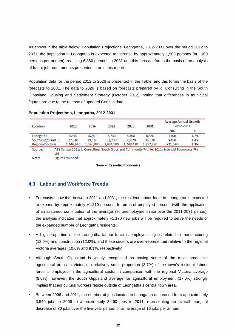
As shown in the table below: Population Projections, Leongatha, 2012-2031 over the period 2012 to
2031, the population in Leongatha is expected to increase by approximately 1,900 persons (or +100
persons per annum), reaching 6,880 persons in 2031 and this forecast forms the basis of an analysis
of future job requirements presented later in this report.
Population data for the period 2012 to 2026 is presented in the Table, and this forms the basis of the
forecasts to 2031. The data to 2026 is based on forecasts prepared by id. Consulting in the South
Gippsland Housing and Settlement Strategy (October 2012), noting that differences in municipal
figures are due to the release of updated Census data.
Population Projections, Leongatha, 2012-2031
Source: Essential Economics
4.3 Labour and Workforce Trends
• Forecasts show that between 2011 and 2031, the resident labour force in Leongatha is expected
to expand by approximately +1,210 persons. In terms of employed persons (with the application
of an assumed continuation of the average 3% unemployment rate over the 2011-2031 period),
the analysis indicates that approximately +1,170 new jobs will be required to serve the needs of
the expanded number of Leongatha residents.
• A high proportion of the Leongatha labour force is employed in jobs related to manufacturing
(13.0%) and construction (12.0%), and these sectors are over-represented relative to the regional
Victoria averages (10.6% and 9.1%, respectively).
• Although South Gippsland is widely recognised as having some of the most productive
agricultural areas in Victoria, a relatively small proportion (3.7%) of the town’s resident labour
force is employed in the agricultural sector in comparison with the regional Victoria average
(8.0%); however, the South Gippsland average for agricultural employment (17.0%) strongly
implies that agricultural workers reside outside of Leongatha’s central town area.
• Between 2006 and 2011, the number of jobs located in Leongatha decreased from approximately
3,540 jobs in 2006 to approximately 3,460 jobs in 2011, representing an overall marginal
decrease of 80 jobs over the five-year period, or an average of 16 jobs per annum.

23
• While total jobs in Leongatha decreased by 80 jobs between 2006 and 2011, the wider
municipality experienced an increase of approximately 470 new jobs over this time. Leongatha’s
rate of job change between 2006 and 2011 of -0.5% pa was below the average growth of +1.0%
pa experienced throughout South Gippsland Shire. Thus, Leongatha appears to be losing a small
number of jobs in recent years, while the balance of the Shire has experienced growth in jobs.
Manufacturing
Manufacturing is the largest sector of the Leongatha economy and accounts for approximately 30% of
GVA, which is much higher than its share of jobs in the town (16%). Other high value-adding sectors
are Rental, Hiring and Real Estate Services: Construction; and Financial and Insurance Services.
Care should be taken in interpreting this information as it relates to a very small area
Declining employment in the manufacturing industry has occurred throughout regional Victoria (and
Australia generally) resulting from broader economic factors influencing the sector. A principal reason
for this decline is due to the significant off-shore location of manufacturing activity from Australia to
other countries (particularly, China) where the costs of manufacturing are significantly lower.
However, between 2006 and 2011, the number of manufacturing jobs located in Leongatha actually
increased from approximately 540 jobs in 2006 to approximately 570 jobs in 2011, representing an
increase approximately 30 jobs over the five-year period.
Most of this increase occurred in the food manufacturing industry sub-sector and directly related to
Murray Goulburn as the only operator in Leongatha. Discussions with Murray Goulburn revealed
recent job losses of at least 38 employees in the past year (i.e., since the 2011 Census was
undertaken) and that the company is undergoing a business-wide review after a recent change in
management structure.
Significant recent investment in plant and equipment by Murray Goulburn at their Leongatha site
encourages a positive outlook for future growth. Murray Goulburn is the major employer in the
Leongatha manufacturing sector, providing approximately 72% of jobs in 2011
4.4 Socio-Economic Characteristics
ABS Census of Population and Housing 2011 data confirms the following features of Leongatha:
• Income: Residents in Leongatha have a particularly high median income ($28,130) compared with
incomes in South Gippsland Shire ($25,170) and the regional Victoria average ($25,740).
• Age Structure: The median age in Leongatha (40 years) is well below that of the South Gippsland
Shire (44 years) and marginally lower than that of regional Victoria (41 years).

24
• Dwelling Structure: Leongatha is characterised by a lower-than-average proportion of detached
dwellings (89.0%) compared with the Shire average (94.5%) and a higher share of occupied
housing stock (89.8%) compared with the regional average (83.0%).
• Home Ownership: Home ownership patterns in Leongatha (40.4%) closely mirror those of
regional Victoria (39.6%).
• Housing Costs: The median monthly mortgage payment in Leongatha ($1,320) correlates to the
regional Victorian median ($1,320); however, rents paid in Leongatha are approximately 10%
higher than the regional median.
4.5 Industrial Land Analysis An audit of all industrial zoned land for the areas of Leongatha, Korumburra and Foster was
undertaken in October 2012. Key findings are discussed below:
• Total Industrial Zoned Land net: The three towns contain 150.7ha of net (ie, excluding roads)
industrial zoned land, including:
- 89.4ha in Leongatha,
- 52.6ha in Korumburra, and
- 8.7ha in Foster.
• Vacant Industrial Zoned Land (Net): A total of 72.4ha of vacant net industrial zoned land
exists, including:
- 35.9ha in Leongatha,
- 32.1ha in Korumburra, and
- 4.4ha in Foster.
48% of industrial land (net) in the three towns is vacant. Although a large proportion of industrial land
is vacant, a range of issues exist which could potentially pose an impediment to future development of
the land, including environmental constraints, topography, infrastructure accessibility, and the like.
Source: Essential Economics
Approximately 85% of all occupied industrial land in Leongatha is taken up by businesses associated
with traditional ‘core’ industrial activities, including manufacturing (45% or 24.2ha), wholesale trade

25
(22%), transport, postal/warehousing activities (12%) and construction (1%). Other Services (7%)
comprises mainly auto-related repair and maintenance.
The remaining 15% of industrial land is occupied by a range of businesses not considered as ‘core’
industrial activities, and these include motor vehicle retailing (including parts) and residential
accommodation. The ancillary businesses often play a supporting role to the core activities which
occur on Leongatha’s industrial land.
Broadly, the principal reasons why non-core industrial activities might be located on industrial land
include:
• Providing direct services to industrial operators (such as food catering for factory workers)
• A requirement for large parcels of land not readily available in non-industrial locations
• Clustering/synergies with industrial operators (eg, research and development, training)
• Increased need to integrate a number of functions from the one operation (eg, production with administration, financial and marketing components)
• Attractive price points / land values.
Vacant land accounted for 40% of the total industrial land supply in Leongatha, noting that this figure
does not take into consideration constraints on existing vacant parcels, such as access, connection
utilities and drainage or land retention by Murray Goulburn for future expansion security
Building Activity
Between 2000 and 2012, 44 industrial building permit applications were submitted in Leongatha for
activities which would typically locate on industrial land. The annual average number of permit
applications over this period was 3.7 per annum; however, building activity appears to have
decreased in recent years, with just 11 permit applications received by Council since 2006. Broadly,
this reduction in activity correlates with subdued economic conditions experienced in the wider
Australian economy, particularly in manufacturing activities.
The trends in industrial building permit data for activities typically on industrial land are summarised in
the Table overleaf titled: The data was sourced from SGSC and adjusted to exclude minor alterations
to existing buildings and omit land uses which would not typically establish on industrial land (eg,
agricultural structures such as hay sheds).

26
Industrial Building Permit Approvals, Leongatha, 20 00-2012
Source: Essential Economics
Industrial Land Take-up
The rate of industrial land take-up is based on a comparison of the 2007 and 2012 industrial land
audits. The vacant industrial land supply excludes the existing road network in Leongatha’s industrial
areas, other uses (including open space), identified drainage land, and land for public facilities.
Development of new facilities on industrial land over this five-year period has resulted in a reduction in
the amount of vacant land in the town. Total vacant land take-up of 3.9ha was evident over the past
five years, and this figure includes an amount of 0.7ha which comprised land acquired for the creation
of an internal road access. Thus, the industrial land take-up rate observed in Leongatha over the past
five years has been an average of +0.8ha per annum.
Having regard for the 35.9ha of existing gross vacant industrial zoned land in Leongatha in 2012, the
town appears to contain an adequate supply of vacant land to accommodate the future industrial land
requirements; however, the figures make no provision for the extent to which existing vacant sites are
appropriate for future development.
A preliminary assessment of ‘net effective developable industrial land’ was undertaken by the
consultant in order to identify land parcels which were easily developable, taking into the obvious
physical characteristics which include topography, drainage, access, known contamination issues,
and flood risks. This visual assessment is intended to identify vacant land where industrial
development appears to be a foreseeable outcome for the site.
The classifications do not take into account non-visual encumbrances, land banking or decision-
making process of individual landowners. The assessment is intended as a guide only.
Of Leongatha’s existing vacant industrial land supply, 30ha (82%) is not easily developable,
Predominantly, land was removed from the overall supply due topography, noting that industrial
27
development in areas of steep slopes requires significant and expensive re-grading for building
structures, parking areas and appropriate transport access.
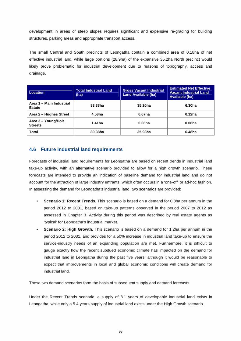
The small Central and South precincts of Leongatha contain a combined area of 0.18ha of net
effective industrial land, while large portions (28.9ha) of the expansive 35.2ha North precinct would
likely prove problematic for industrial development due to reasons of topography, access and
drainage.
Location Total Industrial Land (ha)
Gross Vacant Industrial Land Available (ha)
Estimated Net Effective Vacant Industrial Land Available (ha)
Area 1 – Main Industrial Estate 83.38ha 35.20ha 6.30ha
Area 2 – Hughes Street 4.58ha 0.67ha 0.12ha
Area 3 – Young/Holt Streets 1.41ha 0.06ha 0.06ha
Total 89.38ha 35.93ha 6.48ha
4.6 Future industrial land requirements Forecasts of industrial land requirements for Leongatha are based on recent trends in industrial land
take-up activity, with an alternative scenario provided to allow for a high growth scenario. These
forecasts are intended to provide an indication of baseline demand for industrial land and do not
account for the attraction of large industry entrants, which often occurs in a ‘one-off’ or ad-hoc fashion.
In assessing the demand for Leongatha’s industrial land, two scenarios are provided:
• Scenario 1: Recent Trends. This scenario is based on a demand for 0.8ha per annum in the
period 2012 to 2031, based on take-up patterns observed in the period 2007 to 2012 as
assessed in Chapter 3. Activity during this period was described by real estate agents as
‘typical’ for Leongatha’s industrial market.
• Scenario 2: High Growth. This scenario is based on a demand for 1.2ha per annum in the
period 2012 to 2031, and provides for a 50% increase in industrial land take-up to ensure the
service-industry needs of an expanding population are met. Furthermore, it is difficult to
gauge exactly how the recent subdued economic climate has impacted on the demand for
industrial land in Leongatha during the past five years, although it would be reasonable to
expect that improvements in local and global economic conditions will create demand for
industrial land.
These two demand scenarios form the basis of subsequent supply and demand forecasts.
Under the Recent Trends scenario, a supply of 8.1 years of developable industrial land exists in
Leongatha, while only a 5.4 years supply of industrial land exists under the High Growth scenario.

28
These findings indicate that the supply of available and serviced industrial property in Leongatha is
very limited. The ongoing provision of suitably zoned land with infrastructure connections for an
appropriate range of industrial uses will be an important consideration for Leongatha into the future.
From 2012 to 2031, the total demand for industrial land in Leongatha is expected to range from
15.2ha (based on recent trends) to 22.8ha (should a larger population and improved economic
conditions stimulate strong demand for industrial property in close proximity to the town).
Having regard for the existing net effective industrial land available in the town (6.5ha), the additional
industrial land required to appropriately serve the demand requirements is estimated to be in the order
of 8.7ha (Recent Trends scenario) to 16.3ha (High Growth scenario).
4.7 Summary
• Population trends: Population forecasts indicate that the resident population of Leongatha
will continue to expand at a faster rate than that of regional Victoria. Between 2012 and 2031,
the population of Leongatha is expected to increase by +1,910 persons, to reach a total of
approximately 6,880 persons in 2031. This represents an average growth rate of +1.7% pa.
Generally, population-driven demand for industrial property is likely to translate into demand
for smaller industrial estates which provide a local service industry function.
• Resident labour force: The number of (net) new residents looking for employment is
forecast to expand by at least 1,210 persons by 2031. These people will be seeking jobs
which are preferably located close to where the residents live, namely Leongatha.
• Industrial land demand: Based on an assessment of recent trends in land take-up and
consideration of a high growth scenario, the estimated demand for industrial property to 2031
will be in the range of 15ha to 23ha. However, it is prudent to build-in an additional 10ha
factor to ensure that land is identified which can accommodate new medium to large industry
entrants. It would be reasonable, therefore, to plan for future demand for industrial land in the
order of 25ha to 33ha over the period to 2031.
• Industrial land supply: An audit of industrial land, undertaken by the consultant in October
2012, has identified that the net developable land stocks in Leongatha are in the order of just
6.5ha. At current take-up rates (2007-2012), this land will be consumed in the next eight years
and potentially in five years if an upswing in demand occurs.
• Forecast additional industrial land requirements: Having regard for the forecast demand
and current supply situation, a significant undersupply of (gross) industrial land exists in
Leongatha. To remedy this imbalance in Leongatha, the need exists for a further 19ha to
26ha (rounded: 20ha to 25ha) to be made available for industrial uses by 2031.

29
5 Issues Analysis
A number of key issues were identified through the course of the study. These issues were drawn
from strategic research, a review of constraints and opportunities, an analysis of Leongatha’s
economic position, service and traffic infrastructure and consultation and engagement with community
and business representatives.
Key issues identified include:
• A need to investigate constraints for existing industrial zoned land including topography, drainage
access and (in particular) servicing.
• A current reliance on particular industries and a need to understand how this may change over
the next 20 years (i.e. are there other forms of industry that need to be accommodated in
Leongatha in the future).
• A need to investigate the adequacy of existing industrial land lot sizes to meet current industry
needs.
• A need to ensure a balance between enough industrial land to meet future needs without creating
an oversupply of land.
• Land use conflict and measures to ensure that future industrial land has appropriate interface
treatments and/or appropriate exposure.
• A need to investigate the pros and cons to clustering / fragmenting industrial areas and ensuring
such land is appropriately zoned for the required uses.
• A need to define Leongatha’s industrial niche and future role.
• The need to identify clear directions for future growth to provide certainty for industry, Council and
the Leongatha community.
• The need to identify land which is least constrained so as to improve affordability and improve the
prospects of future development.
• A need to investigate how to attract skilled labour force to Leongatha.
A discussion of these issues commences overleaf

30
5.1 Response to key issues
A discussion of the main issues facing industrial land development in Leongatha is provided below,
having regard to:
• The completion of background research and investigations.
• Analysis of mapping data, zones and aerial photography of the town.
• Site visits undertaken in October 2012.
• Consultation and engagement with local stakeholders, Council; and authorities.
• Analysis of constraints and opportunities affecting the town.
The importance of Murray Goulburn to Leongatha
Murray Goulburn’s prominent milk processing facilities in the northern part of town is a key to
Leongatha’s economic health and employs approximately 400 staff, accounting for 12% of the town’s
total jobs. Manufacturing is the major contributor to the town’s economic output and this sector
employs approximately 570 persons, according to the latest ABS Census data for 2011. However,
this does not necessarily indicate that all manufacturing jobs are in Leongatha.
The plant, which operates 24 hours a day, seven days a week, sources milk from the region’s
surrounding farms and provides direct on-site employment for approximately 400 workers. Historically,
industrial development was largely associated with the agricultural activities in the surrounding area;
this was followed by new businesses establishing in the town to fill direct and intermediate supply
chain gaps.
Today, many surrounding businesses continue to be associated with Murray Goulburn and other dairy
industries, either directly or indirectly. The local Industrial sector also includes a range of small
independent businesses which manufacture products for agricultural and other industries as well as
transport manufactured products.
There is a need to recognise the importance of Goulburn Murray as a significant local employer, and a
significant contributor to the local and regional economy. Future industrial development will be
associated with retaining and nurturing this key business and enabling it to expand operations by
attracting new businesses to fill direct and intermediate supply chain gaps.
A need to improve the diversity of local employment
As identified above, Leongatha relies strongly on Goulburn Murray to supply a significant amount of
employment to the town. As a whole, Leongatha would greatly benefit from a more diverse economy
to provide ongoing stability.

31
Flexibility is required to provide for industrial land of a variety of different sizes meet current and future
industrial needs. This is because the market may respond in a number of different ways in future with
respect to lot sizes, lot configurations, locations, buildings, and different forms of land use. This can
be encouraged by:
• Providing a sufficient amount of zoned industrial land to meet current and future needs.
• Identifying land for short, medium term, and long term industrial growth.
• Ensuring that industrial land is appropriately serviced by transport and infrastructure.
• Providing a flexible planning framework to allow for the consideration of a range new
opportunities, through:
o Changes to zoning
o Changes to local planning policy to encourage lots of a variety of different sizes.
o Applying the Development Plan Overlay to key sites and industrial growth areas to
encourage a strategic and integrated approach to their future planning.
o Establishing principles or criteria to enable the consideration of new employment
opportunities outside of those identified in this report.
Council has also raised the issues that some uses (including Rural Trade Supplies) currently located
in the Industrial Zone, may over time, relocate to areas outside of the main industrial area which do
not require the full ‘suite’ of services available in the main industrial area. This may in turn “free-up”
land within the existing industrial areas for other industrial uses.
A need to identify land for future industrial growt h
This study has identified that Leongatha will require additional industrial land to meet forecast future
needs.
Population forecasts indicate the resident population of Leongatha will continue to expand faster than
that of regional Victoria. Between 2012 and 2031, the population of Leongatha is expected to increase
above 1,910 people to reach at least 6,880 people in 2031. This is an average growth rate of at least
1.7% pa. Population-driven demand for industrial property is likely to translate into demand for smaller
industrial estates providing a local service industry function.
Forecast strong population growth in Leongatha will drive demand for additional industrial land
because:
• Population growth will drive demand for additional service-based industry requiring small
industrial lots in close proximity to town;
• A portion of the people moving to Leongatha over the next 20 years will potentially bring their
small businesses, some of which may require industrial land; and

32
• Leongatha’s increased future resident population may provide an adequately sized and skilled
workforce to enable the attraction of other large industrial businesses to the town.
An audit of industrial land has identified net developable land in Leongatha is 6.5ha. At current take-
up rates (2007-2012) this land will be consumed in the next eight years and potentially in five years if
an upswing in demand occurs.
Given the reliability of forecasts over the short-medium term, it is reasonable to assume that addition
land will be required to meet medium term needs. This report has identified a need for a further 20ha
to 25ha of industrial land to be made available for industrial uses. The report also provides direction
for longer term growth.
Understanding and resolving constraints on existing zoned industrial land
A number of opportunities and constraints to industrial growth apply within Leongatha. Investigations
undertaken as part of this study are important to understanding that where land has been identified for
industrial growth, it can be delivered for that purpose. This includes investigating a number of
constraints including, land use related, economic related, environmental, access and movement, and
infrastructure.
Through the consideration of the relevant opportunities and constraints applicable to current and
future industrial land, realistic short and long term expectations can be set as to where future land
would be best located and how much land should be made available.
The industrial land audit undertaken as part of the project identified total vacant industrial land at
35.9ha within existing industrial zones but much of this land cannot be brought to the market because
it is constrained, requires capital outlay to grade or remediate or other reasons.
• Constraints on some parcels of land within the existing industrial zone due to a lack of
appropriate threshold distances from residential uses (South precinct
• Constraints associated with steeply-sloping or flood-prone land.
• Pressure from non-industrial activities on industrial zoned land, such as accommodation,
recreation activities, residential and retail uses
• Traffic issues through undulating industrial areas, creating access difficulties for heavy
vehicles and complaints from suppliers.
To further examine these issues, a high level investigation of the constraints to industrial growth on
existing and potential future industrial land was undertaken Refer to Section 7). Investigation areas
were established (areas where current of future industrial land could potentially be located). Further
analysis was undertaken to understand the constraints applicable to each investigation area.
Constraints were grouped into five main categories:

33
• Land Use
• Infrastructure
• Access and Movement
• Environment
• Economic
High level infrastructure costs were also established to understand the potential to improve land
potential. Comparisons of site suitability have been formed through analysis of the constraints and
opportunities presented by each investigation area. This work has provided Council with improved
certainty as to the constraints and opportunities present, and direction as to the most appropriate
locations for future industrial growth.
The need for appropriate interface treatments to ma nage conflict between industry and other
land uses.
The interface (relationship) between land uses in industrial areas and other uses in surrounding areas
(ie: farming, residential, commercial) requires consideration through this study. The Study seeks to
ensure that both current and potential future uses are not constrained.
Land Use has been considered in undertaking a review of constraints and opportunities for each of
the investigation areas subject to this study. In particular:
• The extent to which adjoining land uses may constrain industrial activity.
• The ability to accommodate appropriate buffers from residential land uses
• The ability for 24-hour industrial operations without generating adverse amenity impacts on
nearby properties, (particularly residential)
A need to define Leongatha’s industrial niche, futu re role, and provide clear direction for
future growth.
Following consultation and engagement with stakeholders and detailed research and investigation
undertaken as part of this study, a number of future directions have been established in this report. It
is intended that directions for growth (Vision, Objectives) will be addressed through future changes to
the South Gippsland Planning Scheme.

34
6 Service and Traffic Infrastructure Assessment
The following provides an extract from a background investigation prepared by Meinhardt titled: “Final
Service and Traffic Infrastructure Assessment, March 2013.” A summary is provided in Attachments
1 and 2 .
Meinhardt undertook service infrastructure investigations in consultation with relevant service
providers to obtain an understanding of existing infrastructure capability and requirements to support
future industrial growth in Leongatha. Future growth projections were discussed with each of the
relevant authorities.
As part of the assessment, Traffix Group reviewed existing traffic infrastructure within Leongatha and
overall opportunities and constraints presented by the existing network. An investigation of potential
future changes to the network was also undertaken.
Key findings presented below.
• Existing industrial land in Leongatha is well serviced by service and traffic infrastructure.
Infrastructure assets which can be leveraged to support future industrial growth in Leongatha
include:
o The availability of water, sewer, and gas infrastructure (including planned upgrades to
the gas network);
o The presence of a saline wastewater disposal facility to support heavy industry; and
o The proposed Leongatha Heavy Vehicle Alternative Route. This would have the dual
benefit of improving access to existing industrial land and providing appropriate
access to the planned future industrial growth area - Area G.
• With the exception of sewage infrastructure, there has been a limited amount of strategic
investigation into Leongatha’s infrastructure capacity. We note that investigations into
drainage, traffic, and water are currently underway. The outcomes of each should be
monitored and assessed in relation to the recommendations which arise from this study.
• The main service infrastructure constraints to existing industrial land relate to drainage issues
and proximity to watercourses in Area 1. This is likely to be existing undevelopable zoned
industrial land within this precinct. It may also limit the ability of the precinct to further expand
to support long-term growth beyond the existing zoned area (ie: further east towards the
creek).
• Feedback from the authorities (albeit at a desktop level) suggests that there are no major or
apparent service infrastructure deficiencies within the study area.
• Feedback from service authorities did not identify impediment to industrial growth within Area
G. In this regard, it is expected that each of the authorities contacted as part of this report had
some previous input the Leongatha Structure Plan 2010 which also identified Area G (Land

35
west of the Golf Course) for future industrial growth. This is evidenced by SGRWC’s planning
for its sewage infrastructure to this precinct.
• It is noted that Leongatha and surrounds are located within the Tarwin River Declared Water
Catchment Area, which requires all areas to be connected to reticulated sewer and water.
• All road networks within existing industrial areas will have capacity to accommodate an
increase in traffic levels expected from further potential development.
• The most significant impediment to industrial growth in Area G is vehicle access. Upgrades
are required to the existing road network to provide sufficient access to, and through to this
area. This could include examination of one or more of the following options:
o 1) Upgrades to Hughes Street and Turner Street to support heavy vehicle access (in
conjunction with the Leongatha Heavy Vehicle Alternative Route).
o 2) A new railway crossing.
o 3) Provision of a secondary access via Wild Dog Valley Road.
• Onus would be placed on future developer (or developers) to contribute to the cost of
infrastructure upgrades to service the area.
• Council could assist in facilitating the future growth of Area G through:
o The introduction of appropriate planning provisions to provide policy support, rezone
the land encourage the delivery of infrastructure to Area G.
o Resolution of the alignment of the Leongatha Heavy Vehicle Alternative Route with
VicRoads, noting the area identified as Area G as requiring future access connections
for heavy vehicles to support industrial growth.
o Preparation of a development plan which covers all of Area G. This would include
working with landholders to undertake detailed investigations
Ultimately, we are of the opinion that - given the limited traffic generation associated with doing so -
the existing industrial areas can be fully developed without the need for any significant upgrades to
the surrounding road infrastructure. The proposed future industrial zone, Area G, is suitably located to
provide good heavy vehicle access to both the South Gippsland Highway and Strzelecki Highway but
is reliant on significant infrastructure upgrades to be viable.

36
7 Identification of potential future industrial lan d The consultant team has considered site selection criteria to determine where future development
could most appropriately be directed. The selection of future locations for industrial development
within the study area will be critically important to ensure that land is delivered that suits future needs.
The opportunity for the establishment of new industrial land will assist in ensuring that investment
(and planned future investment) in infrastructure is appropriately utilised.
Currently there is an estimated 35.9ha of vacant industrial zoned land in Leongatha. Some of this
land however is subject to development constraints through environment, topography, infrastructure,
accessibility, flooding or drainage issues. The need to investigate other possible locations for future
industrial land is therefore a priority to ensure sufficient land is available to accommodate future
growth.
Due to constraints on available land parcels in both existing industrial land, and investigation areas
identified through this study, the establishment of a preferred location for industrial growth is
challenging,
The Leongatha Structure Plan (2008) identifies a 31.3ha cluster of Farming zoned parcels (named
Area G), located between the existing industrial zoned area and the South Gippsland Highway
adjacent to the recreation reserves (golf course and tennis courts), for a future industrial rezoning.
The Structure Plan specifies that the development of appropriate actions required to activate this
precinct of land for industrial development will be of significant importance to the town.
7.1 Investigation areas The consultant team has assessed potential sites capable of accommodating expansions in the
supply of industrial land (including Area G as referred to above). Eight sites have been examined
(including three existing sites). These are:
Investigation Area
1. Main Industrial Estate (existing)
2. Hughes Street (existing)
3. Young/Holt Streets (existing)
4. Land adjacent to Golf Course (Area G)
5. Aerodrome
6. Existing Pony Club
7. Saleyards (Hogans Road, North Koonwarra)
8. Proposed Other (Adjacent to existing industrial areas)
37
7.2 Location principles In determining the suitability of sites for potential rezoning to enable industrial development, regard
has been given to the following factors that influence the attractiveness of land for industrial
development:
• Accessibility to the wider regional labour market
• Spatial relationship with other industrial precincts, especially having regard for the close inter-industry linkages that are apparent in Leongatha
• The extent to which adjoining land uses may constrain industrial activity
• Ability to accommodate appropriate buffers from residential land uses
• Infrastructure provision in terms of utilities and services, transport access and travel routes to deliver product to end market, etc
• Ability to enable ongoing expansion of the site (ie, not constrained physically)
• Ability to sub-divide in a flexible manner to cater for small lots and to allow for the attraction of larger uses if this opportunity arises
• Allows for 24-hour operations without generating adverse amenity impacts on nearby properties, particularly residential properties
• Provides sufficient space for adequate parking and turning space for delivery vehicles (mainly B-Doubles, but potentially Higher Productivity Freight Vehicles)
• Is well-located in relation to freight connections and other important road and/or rail networks
• Provides unconstrained vehicle access and exit
• Can be commercially developed with infrastructure and site preparation for future industrial activities.

38
7.3 Site selection criteria Based on the location principles - opportunities and constraints can be grouped into five main
categories, and used as site selection criteria. Each of the site selection criteria are defined below:
The site selection criteria have been applied in the Opportunities and Constraints matrix overleaf.
• Existing Land Use • Existing zoning and policy
framework supporting this land use.
• Potential future land use • Potential for land use conflict
(sensitive interfaces) • Land ownership • Land size • Buffers
A) LAND USE
• Water • Electricity • Sewer • Gas • Waste disposal • Telecommunications • Drainage
B) INFTRASTRUCTURE
• Access to site. • Access to local road network • Access to major freight
routes. • Space to enable parking and
turning of vehicles. • Ability to accommodate
heavy vehicles
C) ACCESS & MOVEMENT
• Topography • Flora and Fauna • Heritage • Flooding • Odour • Noise
D) ENVIRONMENT
• Spatial relationship to other industrial precincts.
• Ability to allow for ongoing expansion
• Flexibility for a variety of different of lot sizes.
E) ECONOMIC

39
7.4 Opportunities and constraints matrix
Investigation Area
Land Use Inf Access &
Movement Enviro Eco Total Comments
1. Main
Industrial
Estate
(existing)
4 3 2 3 4 16
This site is within close proximity to existing industrial area and provides an opportunity for significant expansion. Existing land use and zoning is adequate for industrial use. Water and sewerage do not extend into the undeveloped part of the estate to the north, however extensions would be available in relative close proximity. Land is constrained in parts by its steep topography, drainage and potential cultural heritage. Access is provided to the developed parts of the estate. Undeveloped areas to the north are constrained by access. To access this land, an alternative route from the Strzelecki Highway via a bridge connection over a watercourse would be required.
2. Hughes
Street
(existing)
3 4 2 3 3 15 Land use and zoning is adequate for industrial purposes however, land size and buffers restrict this area. Current service infrastructure is appropriate. A small proportion of land in the north western corner of the precinct could be made available for industrial use through access improvements.
3. Young/Holt
Streets
(existing)
1 4 3 3 1 12 This site is the most restricted in terms of land use size and proximity to residential uses (noise impacts). Access and infrastructure is appropriate for industrial use. There are no significant environmental constraints. There is very little opportunity for expansion within or outside of this investigation area.
4. Land
adjacent to
Golf Course
(Area G)
4 3 2 3 5 17
This site was identified for future industrial use in the Leongatha Structure Plan (2008) and provides a number of opportunities in terms of its spatial relationship to other industrial precincts, size, separation from sensitive uses, and flexibility for further expansion. It is possible that a connection to the water mains and other infrastructure from the could be made. Access is restricted and would require upgrade. Environmental constraints would be addressed through detailed masterplanning.
5. Aerodrome 3 1 1 3 3 11
Existing zoning provides an allowance for aviation related uses associated with the aerodrome. The aerodrome itself is a significant asset, and may provide the basis by which further investment in associated infrastructure and aviation related uses could be explored. Detailed masterplanning would need to be pursued to rezone the airport to a special use zone that would allow expansion of aviation related industry and other uses. The land is unlikely to provide for industrial uses given its separation from the Leongatha township area. Upgrades to existing access and infrastructure to the site would be required. Costs are likely to be significant.
6. Existing
Pony Club 2 3 4 3 2 14
This area is well located in terms of its proximity to the surrounding urban area. The cost of extending infrastructure to the site would be minimal. The land is somewhat restricted in terms of its size and the potential for conflict with surrounding uses (residential). Drainage from the site would require further investigation. Access to the site would also be required to be upgraded.
7. Saleyards,
Hogans
Road, N.
Koonwarra
2 3 3 3 2 13
The Saleyards are a significant local, and regional asset. Of further advantage, sewer and water are located in relatively close proximity to the area. The land is unlikely to provide for industrial uses given its separation from the Leongatha township area, however uses which benefit from location adjacent to the Saleyards could be explored, i.e. agricultural retail and servicing uses. Detailed masterplanning would need to be pursued. Upgrades to access would be required. Further investigation would be required for any environmental constraints.
8. Other
(Adjacent to
existing
industrial
areas)
3 1 2 2 2 10
The only area adjacent to existing industrial areas which may allow for expansion is land north of precinct 1. This site provides potential in terms of its spatial relationship to other industrial precincts and flexibility for expansion however is restricted in terms of topography and potential flora and fauna. Upgrades to services and roads would be required. Further investigation would be required for any environmental constraints. It is noted that Council has had discussions with a number of large industrial businesses over time. In the event that such a business cannot locate within the existing or proposed industrial areas within Leongatha then strategic justification will be considered by Council to facilitate this use.
Key 1 – Very high constraint 2 – High constraint 3 – Medium constraint 4 – Low constraint 5 – Very low constraint
Site selection criteria (refer previous page)

40
7.5 Indicative infrastructure upgrade costs Indicative costs to provide suitable infrastructure to the boundary of each investigation area is
provided in the table below. A more detailed breakdown of actual works required and the costs of
these works is provided in Attachment 3. We note that infrastructure costs are high level, and have
been calculated based on delivery to the site. Additional costs will be required to provide
infrastructure to develop each site. A Statement of construction costs is provided in Attachment 4 .
• Costs associated with the delivery of infrastructure to access vacant or underutilised land
north and west of area 1 (Options 1 and 8) are significant. This is mainly due to the need for
road upgrades and the construction of a new bridge to provide access to the land. Given the
amount of land available, it is plausible that a business or industry of considerable scale could
choose to invest in these upgrades.
• Costs associated with the delivery of infrastructure to Area 2 and 4 are also significant,
however could potentially be shared through upgrades to Hughes Street. Precinct 4 is also
likely to deliver significant lot yield, meaning that investment in infrastructure upgrades are
likely to provide most value in terms of providing new industrial land.
• Infrastructure delivery to Area 5 would be significant. This is due to its distance from existing
infrastructure and the cost to upgrade the existing road and extend infrastructure to this
remote location. It is possible that this may be co-ordinated through a masterplanning
exercise.
• Infrastructure can be delivered to the Pony Club (Area 6) at relatively low cost. This is due to
connection points being available at relatively close proximity.
• Infrastructure can be delivered to The Saleyards (Area 7) at relatively low cost. This is due to
connection points being available at relatively close proximity.
• It should be noted that the high level infrastructure costs provided could potentially vary by up
to 60% (15% allowance for traffic management; 15% allowance for contractor uplift; 10%
Investigation Area
Estimated cost to upgrade local infrastructure
1.Main Industrial Estate (existing) $2,236,000
2. Hughes Street (existing) $1,734,000
3. Young/Holt Streets (existing) No land to upgrade
4. Land adjacent to Golf Course (Area G) $1,152,000
5. Aerodrome $3,044,100 (est)*
6. Existing Pony Club $176,600
7. Saleyards (Hogans Road, North Koonwarra) $274,000
8. Proposed Other (Adjacent to existing industrial areas) $1,035,000

41
allowance for planning and design and 40% allowance for contingencies (less 20% already
incorporated due to estimated conceptual cost)).
* The distance of infrastructure connection points to the aerodrome is considerable, meaning that an accurate infrastructure cost is difficult to establish.
7.6 Consideration of options for future industrial land Based on an examination of opportunities and constraints within each investigation area: • Existing Industrial Areas 1-3 – Leongatha’s existing industrial areas will continue to provide for
ongoing industrial use. There is some further growth potential within Areas 1 and 2 specifically. It
is likely that constraints may prevent Area 1 from being realised to its full potential. Undeveloped
industrial land within Precinct 1 could be unlocked through the construction of a bridge from the
Strzelecki Highway.
• Area 4 – Land west of the Golf Course would appear to provide the most logical future direction of
industrial growth given its proximity to the existing urban area. This will enable lower cost
transport connections and service infrastructure connections to support industrial use. The land is
of a size to accommodate future industrial growth in a single cluster, and is well separated from
sensitive uses. The key constraint to overcome is access to the site. More detailed
masterplanning would seek to provide for a design which resolved drainage and other
environmental issues. The precinct’s future use for industrial purposes has also been
foreshadowed since 2008 via the Leongatha Structure Plan.
• Area 5 – The Aerodrome could provide for airport related uses, include transport, and logistics
uses leveraging the airport. This role should be supported by this study. This area is not
considered appropriate to accommodate the town’s future industrial expansion, as not all
industrial uses required to support future growth are likely to derive benefit from location adjacent
to the aerodrome. Other land is better located to allow for a greater flexibility of future industrial
uses, proximity to transport, infrastructure and other industrial uses.
• Area 6 - This area would provide a relatively low cost extension (infill opportunity) within the
existing urban area. When drainage and topography constraints are addressed, the land would
unlikely generate a significant lot yield.
• Area 7 - The Saleyards are a significant local and regional asset. Of further advantage, sewer
and water are located in relatively close proximity to the area. The land is unlikely to provide for
industrial uses given its separation from the Leongatha township area, however uses which
benefit from location adjacent to the Saleyards could be explored, i.e. agricultural retail and
servicing uses. Detailed masterplanning would need to be pursued. Upgrades to access and
infrastructure capacity could be required.
• Area 8 - Most existing industrial areas offer little ability for outward expansion due to interfaces or
existing built up areas. Area 1 is the exception, with undeveloped industrial and farmland to the

42
north and east. Area 1 is heavily constrained in these directions by topography and is unlikely to
be appropriate for further outward expansion.
It is noted that Council has had discussions with a number of large industrial businesses over
time. In the event that such a business cannot locate within the existing or proposed industrial
areas within Leongatha then strategic justification will be considered by Council to facilitate this
use.
• Other areas – No other areas have been identified as suitable to accommodate future industrial
growth. It would be reasonable to provide guidance (ie: establish guiding principles) to enable the
consideration of areas other than those discussed in this report.

43
8 Conclusion Meinhardt has prepared an Industrial Land Supply Study for Leongatha and surrounds. The Study
seeks to provide strategic direction for Leongatha’s future industrial growth. Through a review and
analysis of relevant documentation and consultation with key stakeholders the following has been
established:
• Population forecasts indicate that the resident population of Leongatha will continue to expand at
a faster rate than that of regional Victoria. Between 2012 and 2031, the population of Leongatha
is expected to increase by +1,910 persons, to reach a total of approximately 6,880 persons in
2031. This represents an average growth rate of +1.7% pa. Generally, population-driven demand
for industrial property is likely to translate into demand for smaller industrial estates which provide
a local service industry function.
• Currently there is an estimated 35.9ha of vacant industrial zoned land in Leongatha. Some of this
land however is subject to development constraints through environment, topography,
infrastructure, accessibility, flooding or drainage issues.
• Net developable land stocks in Leongatha are in the order of just 6.5ha. At current take-up rates
(2007-2012), this land will be consumed in the next eight years and potentially in five years if an
upswing in demand occurs.
• Having regard for the forecast demand and current supply situation, a significant undersupply of
(gross) industrial land exists in Leongatha. The need exists for a further 19ha to 26ha (rounded:
20ha to 25ha) to be made available for industrial uses by 2031.
Based on the above, there is need to investigate possible locations for future industrial land to ensure
sufficient land is available to accommodate future growth.
Following a review of Leongatha’s industrial needs, opportunities and constraints, Council should
seek to industrial growth opportunities as follows:
• Key focus should be on Areas 1-4 to provide ongoing and future industrial growth over a 20 year
time horizon (refer map overleaf).
• In the event that additional land is required, land within the vicinity of Area 4 should be identified
for long term growth (refer map overleaf).
• Strategic direction should be provided for the use of land outside of these areas.

44
Recommendations are made in this context:
2
3
1 4
Area 2 – Hughes Street
Area 3 - Young and Holt Streets
Area 4 – Precinct G
Possible long term expansion area
Area 1 – Main Industrial Estate
Existing and proposed future Industrial Land

45
9 Recommendations Recommendations are structured as follows
• An overall vision to guide industrial development in Leongatha.
• Objectives.
• Strategic directions
9.1 Vision
“Over the next 20 years, Leongatha will offer sustainable opportunities for industrial growth and
employment, building on its strong reputation for agricultural production and diary processing.
Leongatha’s fertile soils, high rainfall and proximity to Melbourne enable the supply of clean, high
quality food products to national and international markets. Leongatha will utlise this position to
provide a diverse range of industrial and commercial opportunities. The addition of new, well planned
industrial land and improvements to major transport infrastructure, will assist in meeting forecast
demand for local products, and improve local prosperity.”
9.2 Objectives
• To provide a sustainable business environment for current and potential future industrial
businesses.
• To ensure an adequate supply of industrial land is available to meet current and future needs.
• To ensure the provision of infrastructure to meet current and future industrial land requirements.
• To encourage a variety of lot sizes to improve the diversity of industrial and employment
opportunities.
• To provide certainty for existing industrial businesses and landholders as to the future role and
function of industrial land.
• To identify surplus or underutilised existing industrial land to explore opportunities for its future
development.
• To encourage an integrated approach to land use planning and infrastructure delivery.
• To encourage economic development opportunities which leverage investment in existing assets
and infrastructure.
• To provide a flexible framework for changes in industrial requirements to be accommodated.

46
9.3 Strategic directions General
• Encourage the retention and expansion of agricultural processing industries.
• Encourage the development of land with a variety of lot sizes to improve the diversity of industrial
and employment possibilities available within Leongatha.
• Advocate for the delivery of planned major infrastructure upgrades to support the further
development of Leongatha’s industries.
• Encourage the development of vacant or underutilised land.
• Encourage future industrial development on land which is provided with town infrastructure.
• Ensure uses with adverse amenity potential locate a sufficient distance from sensitive uses.
• Encourage well designed industrial development, which is safe and functional in its layout.
• Encourage industrial development that does not detract from the amenity of surrounding area.
• Ensure that industrial development is designed and constructed to responsive environmental
design standards.
Existing zoned industrial land
Area
Strategic directions
1. Main Industrial Estate 2. Hughes Street 3. Young/Holt Streets
• Encourage the retention and expansion of processing industries within
Precinct 1. • Encourage industrial development within existing vacant industrial 1
zone land. • Resolve and implement the findings of Council’s drainage strategy. • Identify surplus or underutilised existing industrial land to explore
opportunities for its future development. • Encourage connectivity to the surrounding road network. This may
include working with potential developers to resolve access issues affecting vacant land within Area 1.
• Ensure uses with adverse amenity potential locate a sufficient distance from sensitive uses.
• Consider application of a standardised development scheme to enable contributions towards the cost of upgrading local infrastructure to be collected.
• Ensure appropriate access for B-Doubles and Higher Productivity Freight Vehicles).

47
Proposed future industrial land
Land identified for long term industrial growth
Other strategic sites
Area
Strategic directions
4. Land adjacent to Golf Course (Area G)
• Rezone land to Industrial 1 and apply the Development Plan Overlay. • Resolve and implement the findings of Council’s drainage strategy. • Prepare a masterplan to guide the future development of the precinct.
This will include examining opportunities for infrastructure and access from the south, and detailed environmental and hydrology investigations.
• Resolve the alignment of the Leongatha Heavy Vehicle Alternative Route with VicRoads and provide appropriate access to the Area from the south.
• Encourage connectivity to the surrounding road network, and potential future extensions to the north.
• Ensure appropriate access for B-Doubles and Higher Productivity Freight Vehicles).
• Provide secondary access via a connection to Wild Dog Valley Road. • Ensure future planning provides appropriate treatment of the Industrial /
Rural interface. • Consider application of a standardised development scheme to enable
contributions towards the cost of upgrading local infrastructure to be collected.
• Encourage new large scale industries to locate within Area 4.
Area
Strategic directions
Land north of Area 4
• Identify this land within the Planning Scheme for possible long term
industrial growth (subject to future investigation).
Area
Strategic directions
5. Aerodrome 6. Pony Club 7. Saleyards
• These sites are not considered appropriate to meet Leongatha’s future
industrial needs. • For Areas 5 and 7, encourage uses which benefit from location
adjacent to an Aerodrome, and Saleyards. • Undertake detailed masterplanning to explore land use options,
feasibility, and design. • Future use of these sites should not compete with or compromise the
development of Area’s 1-4. • Restrictions on the type of permissible uses for each would be required. • Encourage the relocation of non-industrial uses to Areas 5-7 to free up
land within the main industrial areas. • Utilise site specific planning controls to tailor specific requirements to
each site. • Ensure future planning provides appropriate treatment of the Industrial /
Rural, and Industrial/Residential interface • Ensure appropriate access for B-Doubles and Higher Productivity
Freight Vehicles). • Consider application of a standardised development scheme to enable
contributions towards the cost of upgrading local infrastructure to be

48
Other areas
collected. • Encourage connectivity to the surrounding road network, and potential
future extensions to the north. • Ensure uses with adverse amenity potential locate a sufficient distance
from sensitive uses.
Area
Strategic directions
Other land
• Rather than “rule out” the prospect of rezoning land, Council seeks to
provide direction for considering proposals for future industrial development / zoning outside of proposed industrial areas.
• Any request to rezone land would need to be supported by strategic justification to satisfy the relevant tests which exist within the planning system at that time. This would include detailed consideration of economic, environmental, and social aspects of any such proposal.
• It would also be necessary to demonstrate that the proposed use could not locate within existing or planned industrial area (sequential test).
• Council would apply a similar approach to “other strategic sites” listed above.
• It is noted that Council has had discussions with a number of large industrial businesses over time. In the event that such a business cannot locate within the existing or proposed industrial areas within Leongatha then strategic justification will be considered by Council to facilitate this use.

49
10 Implementation
10.1 Purpose The purpose of the Implementation Plan is to set out the actions necessary to deliver the strategies
outlined in this Study. The Implementation Plan identifies:
• Responsibility for delivery
• Sequencing
• Statutory implementation options
10.2 Responsibility for delivery The recommendations of the Study will be delivered by various Council departments, with support
from external Government agencies and funding obtained from private developers (where
appropriate). The South Gippsland Shire Council will be the primary facilitator of the implementation
actions contained within the Study. Other external Government agencies will be involved in the
implementation of certain actions. These include:
• VicRoads.
• VicTrack.
• Department of Transport (DoT).
• Department of Planning and Community Development (DPCD).
• Department of Sustainability and Environment (DSE).
• Regional Development Victoria (RDV).
• Catchment Management Authority.
• South Gippsland Water.

50
10.3 Sequencing
The sequencing strategy has been designed to provide general guidance in relation to the preferred
staging of future development in order to ensure that growth is undertaken in a co-ordinated and
orderly manner.
It should be noted that there may be instances where the preferred staging of growth may not be
achievable. Land identified for growth may be constrained by a variety of different factors. In many
cases, these constraints may be overcome through more detailed investigation, planning, and
negotiation. The sequencing strategy has been developed to reflect the time in which overcoming
constraints may reasonably be anticipated to be resolved.
Short term (1 – 5 years)
• Promote and utlise available land within existing Industrial 1 Zone (Areas 1, 2, and 3) for short
term future industrial land supply.
• Work with Government Agencies to resolve access, movement, and infrastructure improvements
to Areas 1-4.
• Re-zone Area 4 to increase the supply of zoned Industrial land in Leongatha.
• Prepare a masterplan for Area 4 to set a framework for the co-ordinated delivery of serviced,
developable industrial land.
• Apply a standardised development scheme (once available) to Area 4 to enable contributions
towards the cost of upgrading local infrastructure to be collected.
Medium term (5-10 years)
• Monitor and review industrial land supply.
• Consider rezoning land within the vicinity of Areas 5-7 for site specific uses (which do not
compromise Areas 1-4).
• Consider opportunities for the masterplanning of Areas 5-7.
Long term (10 – 20years)
• Monitor and review industrial land supply.
• Consider re-zoning land north of Area G for future longer term industrial land use as may be
required where it can be demonstrated that additional land supply is required.

51
10.4 Statutory Implementation Statutory implementation of the Study will involve the use of a range of planning tools available within
the Victoria Planning Provisions. This will ensure the effective integration of the Study into the South
Gippsland Planning Scheme.
Statutory implementation will be managed by South Gippsland Shire Council. The final format and
staging of statutory implementation measures will be determined through detailed discussion with the
Department of Planning and Community Development (DPCD), and will be the subject of future
Planning Scheme Amendments to the South Gippsland Planning Scheme.
Municipal Strategic Statement (MSS)
• Reference to the Study and its vision and key directions.
• Reference to the application of zones and overlays which reflect the directions of this report.
• Identification of further strategic work to be carried out.
• Inclusion of the Study as a Reference Document to the Municipal Strategic Statement, and
relevant overlay schedules in the South Gippsland Planning Scheme
Local Policy - Clause 22.05 Industrial Development
• Review the effectiveness of this Clause 22.05 Industrial Development in providing appropriate
industrial design outcomes. Where possible, consider removing or clarifying unnecessary
requirements which inhibit industrial and employment growth in Leongatha and other areas within
the Shire.
Rezoning
• Rezone Area 4 to Industrial 1 (IN1Z).
• Consider the application of site specific zones (ie: Special Use Zone) to Areas 5-7, tailoring the
schedule of the zone to a particular purpose.
Development Plan Overlay
• Apply to Area’s 4-7 to require the form and conditions of future use and development to be shown
on a development plan before a permit can be granted. This will, improve the likelihood of
development being undertaken having regard to site context and the effective delivery or upgrade
of infrastructure, open space and linkages.

52
Standardised Development Contributions Levy
Consider application of a Standardised Development Contributions Levy.
In May 2012, the Minister for Planning announced that the Government will make available a new
system of standard levies that can be selected and applied to different development settings. This
new system would give Councils a set of standard development contribution levies for different
development settings around the five infrastructure categories:
• Community facilities
• Open space facilities
• Transport infrastructure
• Drainage infrastructure
• Public land.
The Minister for Planning appointed an Advisory Committee (chaired by Ms Kathy Mitchell) to provide
advice on the final framework for the new standard development contribution system. The
Committee’s final report is due to be released by 31 May 2013. Report 1: Setting the Framework was
released for public comment on 17 December 2012.
It is understood that following the Committee’s final report, the standard development contribution
system will be introduced into the Victorian planning system via ‘fast tracked’ Section 20(4)
Amendments.
Specifically in relation to the Study, we note:
• The anticipated introduction into all Victorian planning schemes is likely to coincide with the
planned completion (and implementation) of the project in the short term.
• The standard system can be tailored for regional areas in relation to future industrial
development.
• The cost savings (preparation and ongoing collection) that can be achieved by opting to use a
standard system.

53
Attachment 1: Infrastructure Servicing Summary
The following provides an extract from a background investigation prepared by Meinhardt titled: “Final
Service and Traffic Infrastructure Assessment, March 2013.”
Meinhardt undertook service infrastructure investigations in consultation with relevant service
providers to obtain an understanding of existing infrastructure capability and requirements to support
future industrial growth in Leongatha. Future growth projections have been discussed with each of the
relevant authorities.
Information was sought in relation to the following infrastructure services:
• Sewer and Water
• Drainage
• Gas
• Electricity
• Telecommunications
A summary of findings is provided below.
Sewer & Water South Gippsland Region Water Corporation (SGRWC) is responsible for the provision of sewer and
reticulated water for Leongatha.
SGRWC also owns and manages a saline wastewater disposal facility comprising a pipeline system
from Korumburra and Leongatha to an existing ocean outfall at Venus Bay on the coast of South
Gippsland, Victoria. The system was initially commissioned in 1969 to service the dairy industry
located in Korumburra and Leongatha. The system is a significant asset to the town of Leongatha.
Advice from SGRWC indicates that existing industrial precincts (Areas 1, 2 & 3) and potential future
industrial Area (G) have been allowed for in their sewer hydraulic modelling in anticipation of
Leongatha’s future growth. Based on this advice, there are unlikely to be substantial service or
capacity issues for new sewer connections to Area G. New connections to the existing sewer system
would however be required.
SGRWC is currently preparing a strategic plan for its water infrastructure, however no information is
currently available to inform this report as to whether there are service or capacity issues which would
be required to be addressed. As per the above, new connections to this system would be required.

54
Discussions with SGRWC would indicate that existing industrial land in Leongatha is appropriately
serviced by Water and Sewer. New connections would need to be established to Area G to enable it
to be serviced (likely at the cost of the future developer of the land). SGRWC advise that any existing
infrastructure augmentation, extension or upgrade would be in line with the Essential Services
Commission guidelines. Planning provisions could be introduced to guide the development of the site
(including the provision and upgrade of infrastructure) to an appropriate standard.
Drainage South Gippsland Shire Council is responsible for the supply of local stormwater drainage. Council’s
Asset Management Department has advised that the recently commissioned a strategic investigation
of drainage issues affecting Leongatha - “Leongatha Traffic and Drainage Study”. The study will
investigate stormwater drainage issues for Leongatha, including the four industrial precincts relevant
to this Study. The Study has not been completed to this point, resulting in information relating to
drainage within the study area being limited.
Based on field observation, discussions with stakeholders, and a review of relevant background
information, we note some factors which would suggest that drainage issues exist within the study
area:
• Topography (runoff from steep slopes – particularly in Area 1).
• Rainfall (Leongatha is situated in a region with higher than annual rainfall than the State of
Victoria).
• Soil type (drainage capability – unknown).
• The presence of watercourses and drainage lines (which are required to be protected to
ensure water quality):
o A 1 in 100 year inundation area has been identified running through this Main
Industrial Estate precinct (1) – north of Strzelecki Highway).
o A watercourse is located to the east of Area 1.
It is likely that drainage constraints and the presence of watercourses may impact on future
development (particularly the overall supply of existing industrial land in Area 1). Undeveloped land
may remain undeveloped due to the cost implications associated with such mitigation works.
If existing industrial land were to remain undeveloped, this would reduce the overall amount of
existing developable industrial land in Leongatha and thus may impact on future industrial growth. It
can be expected that the Leongatha Traffic and Drainage Study will address these issues in further
detail. For further information regarding land supply, please refer to the Stage 2 Economic and
Strategic Planning Analysis.
A drainage assessment would be carried out by the future developer of Area G. Drainage assets
would need to be designed and constructed to Council’s local engineering standards, as reflected in
the Infrastructure Design Manual.

55
Gas Multinet is the authority responsible for the provision of natural gas service in Leongatha.
Existing industrial areas 1, 2 and 3 are fully serviced with reticulated gas with mains in all major roads
within the town. Upgrade works are proposed along Strzelecki Highway, Watson Road and Geary
Road.
Area G is not currently serviced by reticulated gas and there are currently no plans to extend the gas
mains into this area. Given that proposed Area G currently has main road access via South Gippsland
Highway, connection to the existing network would be possible. New connections would need to be
established to Area G to enable it to be serviced (likely at the cost of the future developer of the land).
Planning provisions could be introduced to guide the development of the site (including the provision
and upgrade of infrastructure) to an appropriate standard.
Electricity SP-Ausnet is the electrical authority for the Leongatha. No strategic advice from SP Ausnet was
forthcoming. SP-Ausnet advised that the capability of the existing infrastructure would be assessed as
demand develops, and the appropriate augmentation/upgrades to the system would be implemented
as required. In this regard, we note that electricity assets are located within close proximity to Area G.
Connection would be at the cost of the future developer of the land.
Telecommunications
Telstra have advised that major telecommunications infrastructure planning for Leongatha will now be
the responsibility of (NBN Co.) All future network upgrades and connections will also be managed by
(NBN Co.).
Telstra has advised that the existing network currently has capacity to service any further growth in
existing industrial zoned areas (Precincts 1, 2 and 3).
We note that there are telecommunication assets located in proximity to Area G. NBN Co has advised
that any upgrade or connection would be at the cost of the future developer of the land.
NBN Co. is also responsible for providing (high speed broadband) telecommunication services to
Leongatha (and elsewhere across Australia). We note that NBN Co’s current rollout schedule for fibre
installation / expansion within the next three years does not include Leongatha.

56
Attachment 2: Traffic Infrastructure Summary
The following provides an extract from a background investigation prepared by Meinhardt titled: “Final
Service and Traffic Infrastructure Assessment, March 2013.”
Traffix Group was engaged to undertake a desktop assessment of existing traffic infrastructure within
Leongatha and overall opportunities and constraints presented by the existing network. An
investigation of potential future changes to the network was also undertaken.
Leongatha Heavy Vehicle Alternative Route
We note that VicRoads confirmed in the ‘South Gippsland Highway Corridor Strategy’ that a
Leongatha Heavy Vehicle Alternative Route was a high priority project. As part of the study into a
Heavy Vehicle Alternative Route, Sinclair Knight Merz (SKM) undertook a study that identified a
number of potential bypass routes. In its review of the SKM study, O’Brien Traffic identified utilising
Hughes and Long Streets as the preferred route, and noted that this was supported by business and
operator stakeholders. O’Brien’s report also recommended upgrading the intersections at both ends of
Turner Street to allow for longer heavy vehicle movements and we agree that this is a logical inclusion
to the heavy vehicle network.
Traffic Generation – Existing industrial land (Area s 1-3)
• The overall peak hour is likely to occur between 5pm and 6pm, with a total of 200 additional
vehicles generated by the full build-out of Area 1. At this time, the heavy vehicle proportion
will be only 4% of the total traffic volume. This coincides with the typical road network peak
hour.
• The AM peak hour will generate in the order of 87% of the PM peak hour traffic and will occur
between 8am and 9am, which coincides with the typical road network peak hour. Again the
heavy vehicle component will be low (less than 4%).
• Over the course of the whole day, the heavy vehicle component is likely to represent in the
order of 11 – 12% of the total traffic, or around 150 heavy vehicle trip-ends per day.
• The busiest hour for commercial traffic is likely to occur in the middle of the day when
surrounding road network traffic is lower. Table 3 anticipates a peak between 1pm and 2pm of
19 commercial vehicles in an hour, closely followed by 18 commercial vehicles per hour
between 10am and 12noon. This corresponds to in the order of one additional heavy vehicle
either entering or exiting Area 1 every 3 minutes on average during the busiest hour for
commercial vehicles, assuming full build-out of the existing industrial land supply in that area.

57
Traffic Generation – Proposed future industrial lan d (Area G)
• The overall peak hour is likely to occur between 5pm and 6pm, with a total of 793 vehicles
generated by the full build-out of Area G. At this time, the heavy vehicle proportion will be only
4% of the total traffic volume. This coincides with the typical road network peak hour.
• The AM peak hour will generate in the order of 87% of the PM peak hour traffic and will occur
between 8am and 9am, which coincides with the typical road network peak hour. Again the
heavy vehicle component will be low (less than 4%).
• Over the course of the whole day, the heavy vehicle component is likely to represent in the
order of 11 – 12% of the total traffic, or around 580 heavy vehicle trip-ends per day.
• The busiest hour for commercial traffic is likely to occur in the middle of the day when
surrounding road network traffic is lower. It is anticipated that there will be a peak between
1pm and 2pm of 74 commercial vehicles in an hour, closely followed by 72 commercial
vehicles per hour between 10am and 12noon. This corresponds to in the order of one heavy
vehicle either entering or exiting Area G every 48 seconds on average during the busiest hour
for commercial vehicles, assuming full build-out of Area G for industrial purposes.
• During the road network peak hours, the volume of commercial vehicles is likely to be
significantly lower based on the profile shown in Table 4 above, with approximately one
commercial vehicle either entering or exiting the estate every 2 minutes on average.
Traffic Assessment of Industrial Sites
Area 1
Area 1 is to the north-east of the Leongatha Township and is divided east-west by the Strzelecki
Highway providing it with excellent access to the arterial road network. We also note that of the
existing sites, Area 1 has the most opportunity for further development. Through the construction of a
Leongatha Heavy Vehicle Alternative Route and the upgrade of Turner Street, we also note that Area
1 will have excellent access to the South Gippsland Highway, allowing for vehicles travelling to
Melbourne to travel northbound without having to traverse the Leongatha town centre.
We note that a review of VicRoads’ arterial road volumes identifies the Strzelecki Highway as having
an existing two-way traffic volume in the order of 8,900vpd. This volume is fairly low for an arterial
route and we note that the Strzelecki Highway has ample capacity to support the additional 1,260vpd
anticipated from the full development of Area 1. Notably, duplication is not typically considered until
two-way daily traffic volumes approach 15,000 vehicles per day. Separate left and right turn lanes are
required into side streets to accommodate this sort of two-way traffic volume on a two-lane two-way
road, and we note that provision for through traffic to pass turning traffic is already provided for on the
Strzelecki Highway.

58
Area 2
Area 2 is located north-west of the Leongatha Township. Area 2 has excellent access to the arterial
road network with both the South Gippsland Highway and Strzelecki Highway (accessed via Turner
Street) within close proximity. However, we understand that the intersection of Turner Street with
Roughead Street (Strzelecki Highway) is of insufficient size to allow for larger heavy vehicles to turn
right or left from Turner Street. Further, we understand that the intersection of Turner Street and
Anderson Street (South Gippsland Highway) is also problematic. Both these intersections would
require upgrading in the future in the event Turner Street were to be used as a heavy vehicle
alternative route. We also note that the anticipated additional future traffic generated by the full
development of Area 2 is minimal, and can be easily accommodated by the surrounding network.
Area 3
Area 3 is located south of the Leongatha Township. It is the smallest of the industrial areas at only
1.41ha of developed land and a further 0.06ha viable for future development. We note that it does
have excellent access to the South Gippsland Highway and is also within close proximity to the
proposed heavy vehicle alternative route which will allow for improved northbound traffic movements
in the future. Ultimately, under a full development scenario, it is anticipated that Area 3 will generate
very few additional traffic movement, which can be easily accommodated on the surrounding road
network regardless of whether the heavy vehicle bypass route eventuates or not.
Area G
Area G is located north of the Leongatha Township and just north-west of the golf course. It is
currently zoned Low Density Residential but has been identified as a potential location for future
industrial development. Currently, access to the area is provided via a single road – Hughes Street.
Hughes Street is an unsealed road that is currently too narrow to support heavy vehicle access.
Accordingly, in the event that Area G were developed for industrial purposes, Hughes Street would
need to be upgraded. We note that some existing vegetation present on both sides of Hughes Street
would need to be removed.
Furthermore, we note that a Hughes Street access is also contingent on Turner Street being
upgraded. Currently, left and right turn movements onto Roughead Road (Strzelecki Highway) from
Turner Street are not possible for larger vehicles. Additionally, there is minimal separation between
the intersection of Turner Street and the South Gippsland Highway and the railway crossing, which
could prove problematic in the event heavy vehicle traffic increases significantly.
Furthermore, the nature of the T-intersection would require heavy vehicles to give way to through
traffic on South Gippsland Highway, which is less than ideal. These issues will be overcome by the
establishment of the proposed heavy vehicle alternative route and associated intersection works.

59
Alternatively, a new railway crossing to the north of the Leongatha Township would provide excellent
access to a future industrial development within Area G. This would negate the need for vehicles
(including heavy vehicles) which access the development to/from the north from entering Leongatha
Township at all, and would not be reliant on the construction of the heavy vehicle alternative route.
However, this solution may be cost prohibitive.
Another alternative access to Area G may be sought from Wild Dog Valley Road, however given the
orientation of Area G, the position of Wild Dog Valley Road within the wider road network, the winding
nature of Wild Dog Valley Road and potential topography issues, we believe Hughes Street ultimately
to provide a better outcome. It may be possible for Wild Dog Valley Road to be used as a secondary
access, providing a more direct route for vehicles travelling between Area G and the northeast
(Morwell and surrounds).
Provision of a secondary access point into the industrial subdivision also has benefits from an
emergency vehicle access perspective, providing an alternative option in the event that one access
road is blocked for some reason (fire or other emergency).

60
Attachment 3: Review of opportunities and constrain ts and infrastructure costs (investigation areas). The following provides an extract from a background investigation prepared by Meinhardt titled: “Final
Service and Traffic Infrastructure Assessment, March 2013.”
A summary of constraints and opportunities for each investigation area was undertaken. This
included:
• The identification of relevant planning controls.
• The main constraints affecting each precinct (having regard to the site selection criteria).
• Commentary regarding the key opportunities and constraints presented by each precinct.
• A summary of infrastructure upgrades which would be required.
• High level costs required to upgrade infrastructure.
It should be noted that the high level infrastructure costs provided could potentially vary by up to 60%
(15% allowance for traffic management; 15% allowance for contractor uplift; 10% allowance for
planning and design and 40% allowance for contingencies (less 20% already incorporated due to
estimated conceptual cost)).
The summary commences overleaf.

61
Main Industrial Estate (existing)
Investigation area Planning controls
Constraints Comments
1 Main Industrial Estate (existing)
IN1Z ESO6 (part) DPO3 (part)
C, D
Leongatha’s Main industrial Estate is home to Murray Goulburn’s Dairy and many other industrial / commercial businesses. The land is constrained in part by its steep topography, drainage lines, and proximity to watercourses. The land will continue to be used for industrial uses. Part of the precinct remains undeveloped. There is potential for some parts of land within the precinct may never be developed due to the presence of the afore mentioned constraints, restricted lot sizes and lack of exposure (main road frontage). Council note that: Opportunities exist to relocate agricultural service industries (such as tractor servicing sale businesses / commercial / business 4 zone uses and industrial 3 zone uses) to Koonwarra freeing up well serviced sites. North of Yarragon Road: • There is a considerable slope on much of
the land but once this has been flattened, the sites will be usable for a long time. The cost of 'benching' these sites can be considered a barrier to uptake/development.
• Sports fields and PPRZ is adjacent to the works which may be impacted by any building works and ongoing traffic access noise, negative externalities from the industrial activity.
• Road access will need to be enhanced requiring treatments to major intersections.
• Drainage and water movements will require significant Water Sensitive Urban Design (WSUD) for ongoing development.
• Gas in close proximity. • Roads in close proximity. • Bridge and new intersection required on
Strzelecki Highway to service area east of Cusack road on flats.
• Considerable flooding risk in the region following either tributary to Coalition Creek prior to crossing the highway. This includes along the creek reserve that bisects Cusack Street.
• Considerable cultural heritage issues 100m either side of Coalition Creek. This would require a Cultural Heritage Management Plan (CHMP) over any lot encompassing any part of the protection area.
• May require existing undeveloped industrial zoned land to be rezoned farm land due to constraints.
South of Yarragon Road: • Future development opportunities are
predominantly relocation of existing businesses to other locations, i.e. Koonwarra.
• There is a known compliance issue with quality of wastewater from current industry. Being investigated by the EPA.

62
Figure 1: Main Industrial Estate (existing)
Figure 2: Main Industrial Estate (existing) (CMA Ma p)

63
Infrastructure upgrade costs
In order to utilise Area 1’s full potential with the vacant lots to the north, the following upgrades would
be required as a minimum:
1. Intersection upgrade from Strzelecki Highway.
2. Access road from Strzelecki Highway.
3. Bridge over Coalition Creek.
4. Water.
5. Electricity.
Infrastructure Works Cost ($)
1. Intersection upgrade
Deceleration lane - 120 m x 3 m x $110 / square metre $40,000
Stormwater – 120 m x $300 / metre $36,000
2. Access road
Road construction – 450 m x 12.5 m x $110 / square metre $620,000
Stormwater – 450 m x $300 / metre $135,000
3. Bridge over Coalition Creek
Bridge construction – 50 m x 12.5 m x $2,100 / square metre $1,315,000
4. Water
Water connection – 450 m x $200 / metre $90,000
5. Electricity
Extend from Cusack Road
No allowance from Strzelecki Highway
Variable – require more detailed design to cost
Total $2,236,000

64
Area 2: Hughes Street (existing)
Investigation area Planning controls
Constraints Comments
2 Hughes Street (existing)
IN1Z
A, C
This area contains a mix of uses including car yards and auto repairs, a caravan park, motel and residential properties. The land is constrained by existing surrounding land uses and zones. Access beyond Turner Street to the west and Money Lane to the east is via an unsealed road. Council note that: • Investigation may be required to the best
zoning of this area (possibly MUZ). • Investigation of whether these uses will
relocate once B4Z is created will need to be reviewed.
• Good servicing limited development opportunities in this area.
• Affected by proposed Heavy Vehicle Alternative Route (HVAR). The HVB is likely to remove roadside parking. This may open up constraints / opportunities. Needs further discussion with VicRoads.
• Strategic justification is required about whether this should be industrial rather than the current residential zoning. Sensitive neighbouring uses and houses that still exist should be addressed, perhaps through an Outline Development Plan (ODP).
• The Heavy Vehicle Alternative Route (HVAR) will affect all activity in this area, as will the proximity to the rail crossing.
• This site is more suited to smaller vehicles and lighter industrial/commercial activity.
• Proximity to the town centre is a positive for servicing and infrastructure.
• Development will produce an unknown impact on the drainage network. A detention/retardation system may be required for longer term development strategies.
• Issues with South Gippsland Water (SGW) servicing pressure and fire fighting supplies.
• There may be some vegetation issues associated with older trees within the area.

65
Figure 3: Hughes Street (existing)
Infrastructure upgrade costs
This area is an established industrial area surrounded by the existing road network and services. One
section within the north western corner of the precinct is currently under-developed. The following
upgrades would be required as a minimum:
1. Hughes Street.
2. Turner Street.
3. Upgrade to the access point at Anderson Street across the railway line.
Infrastructure Works Cost ($)
1. Hughes Street
Road construction – 400 m x 12.5 m x $110 / square metre $550,000
Stormwater – 400 m x $300 / metre $120,000
Water connection – 400 m x $200 $80,000
2. Turner Street
Road construction – 400 m x 12.5 m x $110 / square metre $550,000
Stormwater – 400 m x $300 / metre $120,000
Water connection – 400 m x $200 $80,000

66
It is noted that only a small amount of additional industrial land would be created / improved by
investing in the above.
3. Anderson Street – Railway line
Road construction – 150 m x 12.5 m x $110 / square metres $210,000
Stormwater – 80 m x $300 / metre $24,000
Total $1,734,000

67
Area 3: Young/Holt Streets (existing)
Investigation area Planning controls
Constraints Comments
3 Young/Holt Streets (existing)
IN1Z
A, C, D, E
The predominant industrial uses in this area include the Cash’s Factory and other electrical trades. Residential properties also exist within this area. Land uses and access therefore limit expansion of this area, in addition to the sloping stepped nature which may limit the types of industry to benefit from this location. Council note that: • There is limited development potential. • Significant areas are covered by residential
housing. • Not the ideal location for heavy industrial
uses and may be more suited to MUZ or commercial town expansion.
• Good servicing. • Heavy vehicle access may create issues. • Road infrastructure is existing but is
designed for residential use. To convert this to industrial, on street parking would be removed for industrial users and indented parking may be required.
• The existing residences would require an Outline Development Plan (ODP) that would address 'buffer' uses next to houses.
• Access to the site from the Bass Highway would be through the residential area, most likely causing complaints/property devaluation.
• Noise would be a major concern. • Investigation required into whether this land
remains industrial or should be rezoned reflecting existing residential use.

68
Figure 4: Young/Holt Streets (existing)
Infrastructure upgrade costs
Given the limited expansion potential for this area, restricted by surrounding uses, the level of
services and access to this area for current and future industrial uses is considered to be sufficient.

69
Area 4: Land adjacent to golf course (Area G)
Investigation area Planning controls
Constraints Comments
4 Land adjacent to golf course (Area G)
FZ ESO5
C, D
This area has been highlighted for future industrial use within the Leongatha Structure Plan (2008). Proximity to existing town service infrastructure excellent. Access to this area is currently restricted via a single, unsealed road from Hughes Street. This is currently too narrow to support heavy vehicle access and would require upgrade. Access from Turner Street would also require to be upgraded. The land would require rezoning and detailed masterplanning to accommodate buffers to watercourses/ drainage lines, and investigation of any EVC’s on the land. Council note that: • The area to the north should be
considered for inclusion and may require subdivision as title boundaries are too extensive.
• A comprehensive drainage plan would be required with the golf course inclusion. CMA have indicated reductions in drainage reserve areas where a comprehensive area wide drainage strategy exists.
• Council have received an application to rezone 3 lots in this precinct to IND1 Zone, approximately 22ha.
• There are sensitive uses, a church, private residence and golf course in the area.
• Overall, distance from the residential areas south of the South Gippsland Highway is a positive factor.
• The road would need to be built to IDM standard. Trees removed, and a stage access upgrade.
• Review intersection design from Vicroads. • Access would be off Bent street before
consideration of a connecting accessway from Wild Dog Valley Road.
• Treatments to access this site would be a considerable barrier to development.
• Likely to be affected by the HVB. • Drainage, waterway buffers and WSUD
would all impact any future development and may be a barrier to entry.
• There exists only one access point along Turner Street which may be a CFA barrier to development.

70
Figure 5: Land adjacent to golf course (Area G)
Figure 6: Land adjacent to golf course (Area G) (CM A Map)

71
Infrastructure upgrade costs
In order to utilise this area for future industrial use, the following infrastructure works required as a
minimum, would include:
1. Formalising of Hughes Street.
2. Creation of an intersection off Wild Dog Valley Road.
Infrastructure Works Cost ($)
1. Formalising of Hughes Street
Road construction – 700 m x 12.5 m x $110 / square metre $965,000
Stormwater – 600 m x $300 / metre $180,000
2. Intersection at Wild Dog Valley Road
Road construction – 60 square metres x $110 / square metre $7,000
Total $1,152,000
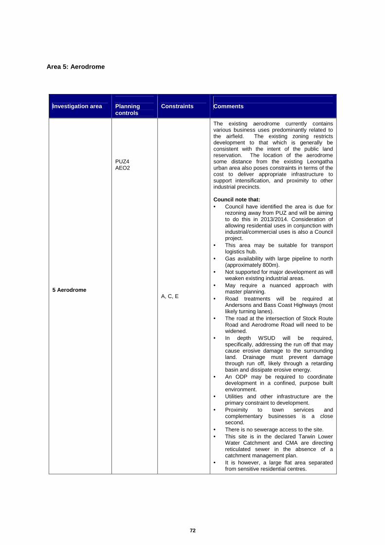
72
Area 5: Aerodrome
Investigation area Planning controls
Constraints Comments
5 Aerodrome
PUZ4 AEO2
A, C, E
The existing aerodrome currently contains various business uses predominantly related to the airfield. The existing zoning restricts development to that which is generally be consistent with the intent of the public land reservation. The location of the aerodrome some distance from the existing Leongatha urban area also poses constraints in terms of the cost to deliver appropriate infrastructure to support intensification, and proximity to other industrial precincts. Council note that: • Council have identified the area is due for
rezoning away from PUZ and will be aiming to do this in 2013/2014. Consideration of allowing residential uses in conjunction with industrial/commercial uses is also a Council project.
• This area may be suitable for transport logistics hub.
• Gas availability with large pipeline to north (approximately 800m).
• Not supported for major development as will weaken existing industrial areas.
• May require a nuanced approach with master planning.
• Road treatments will be required at Andersons and Bass Coast Highways (most likely turning lanes).
• The road at the intersection of Stock Route Road and Aerodrome Road will need to be widened.
• In depth WSUD will be required, specifically, addressing the run off that may cause erosive damage to the surrounding land. Drainage must prevent damage through run off, likely through a retarding basin and dissipate erosive energy.
• An ODP may be required to coordinate development in a confined, purpose built environment.
• Utilities and other infrastructure are the primary constraint to development.
• Proximity to town services and complementary businesses is a close second.
• There is no sewerage access to the site. • This site is in the declared Tarwin Lower
Water Catchment and CMA are directing reticulated sewer in the absence of a catchment management plan.
• It is however, a large flat area separated from sensitive residential centres.

73
Figure 7: Aerodrome
Infrastructure upgrade costs
The aerodrome site is located a considerable distance from the Leongatha town area. Information
relating to site serving is limited. Significant infrastructure works would be required should this area be
utilised for future industry. It is noted that there is no formal drainage at this location, with a retarding
basin located at the northern end of the existing runway and controlled discharge into adjacent
paddocks.
The cost of these works is likely to be far in excess of other options outlined through this investigation.
In addition to service infrastructure upgrades the following road upgrades would be required as a
minimum:
1. Road upgrade works along the length of Aerodrome Road.
2. Turning lanes at Andersons Road and Bass Highway.
3. Road widening at the intersection of Stock Route Road and Aerodrome Road.

74
Infrastructure Works Cost ($)
1. Road upgrade works along the length of Aerodrome Road
Road construction – 1300m x 8 m x $85 / square metre $884,000
2. Turning Lanes at Andersons Road and Bass Highway
Road construction – 200 m x 3.5 m x $110 / square metre $77,000
Stormwater – 200 m x $300 / metre $60,000
3. Road widening at Stock Route Road and Aerodrome R oad intersection
Road construction – 60 m x 3.5 m x $110 / square metre $23,100
4. Other servicing upgrades (sewer, water, drainage , power, gas, telecommunications)
$2,000,000+ (est)
Total 3,044,100+ (est)*
*The distance of infrastructure connection points to the aerodrome is considerable, meaning that an accurate infrastructure cost is difficult to establish. Based on a desktop review of existing information, we believe there to be significant cost in providing town services to the airport site.

75
Area 6: Existing Pony Club
Investigation area Planning controls
Constraints Comments
6 Existing Pony Club
PPRZ
A, E
This area is ideally located next to the existing industrial area 1 and could potentially allow for an extension of these areas further south. Industrial uses are currently prohibited by the zone. This area is restricted however by the amount of land available and the surrounding abutting residential properties, limiting the extent of further growth. Council note that: • Consideration should be given to potential
re-zoning to IN3Z/MUZ with a master plan. • Well serviced site. • Detailed landscaping would be required. • Good access off Tilson Court and Horn
Street. • This is well suited to industrial use and
represents a natural continuity of the current industrial precinct.
• The proximity to residential land would dictate a light industrial/commercial zone (perhaps a business park) accounting for compatible uses with the nearby community.
• There is slope on the land that would need to be addressed before industry moved onto the land.
• This is a sensitive political issue as the community use is a good buffer and the option for the equestrian club would be a movement down to Stony Creek.
• There would need to be work on the roads that service this land to widen the usable surface and install service roads to lots.
• Detailed WSUD and landscaping would need to be applied through Development Plan.
• Earthworks / infrastructure is likely to be a barrier to use depending on the type of industry suggested for use.
• This site will require a clear recommendation regarding the most strategically justifiable zoning.
• Note: SP Ausnet is currently rezoning their site in this area from MUZ and R1Z to SUZ at Horn Street.

76
Figure 8: Existing Pony Club
Infrastructure upgrade costs
Key upgrades required as a minimum to allow adequate access into this area for industrial use include:
1. Upgrade works to Watson Road from Geary Road.
2. Sewer / stormwater to the area.
3. Intersection at Horn Street.
The sewer main currently exists in Watson Road and can be connected to for the southern half of this
site. The northern half of the site can be connected to Yarragon Road through the reserve between
the existing residential lots.
Water can also be connected via similar existing infrastructure.
Stormwater may require further investigation however, as the area of land north of Tilson Court is
restricted in terms of overland flow paths due to existing surrounding properties and the narrow
reserve available to release this water.

77
Infrastructure Works Cost ($)
1. Upgrade works to Watson Road from Geary Road
Road construction – 100 m x 12.5 m x $110 / square metre $140,000
Stormwater – 100 m x $300 / metre $30,000
2. Sewer / stormwater
Requires further investigation Unknown
3. Intersection at Horn Street
Road construction – 60 square metres x $110 / square metre $6,600
Total $176,600+

78
Area 7: Saleyards (Hogans Road, North Koonwarra)
Investigation area Planning controls
Constraints Comments
7 Saleyards (Hogans Road, North Koonwarra)
FZ ESO5 ESO6
A, B, C, E
This area is located outside of the Leongatha township to the south. The location some distance from the existing Leongatha settlement poses disadvantages in terms of industrial land use patterns and clustering. Although it is ideally located on a main Highway route, access along Hogans Road is limited via a single track dirt road. Current land use zoning prohibits any industrial use other than that associated with rural industry or a transfer station. This area is also located within an area of Environmental Significance with sections containing protected EVC’s and is surrounded soley by farm land and other associated rural uses. This would require further investigation if this land were to be developed. Council note that: • Possible re-zoning may required to SUZ for
rural service industries. • Area requires communal water supply
servicing which can be required by master plan, otherwise each development is required to provide own facilities.
• There may be benefit to move low service demand business out of heavily serviced Leongatha.
• This area has a sensitive interface with the Rail Trail.
• Water supply is a main constraint to development. The CFA requires considerable water storage on site for fire fighting. In a previous planning permit, the applicant/owner must provide "a minimum of 10000 litres on-site static storage must be provided and be maintained solely for fire fighting".
• Currently used for some bulky goods with excellent access to the highway.
• VicRoads will be completely in charge of the access to the sites. It would be likely they will require access north of Windmill Ag. One access point to all lots that would be fully developed allowing for full development scenario.
• Drainage may be an issue although a culvert connected under the highway to the existing waterway.
• WSUD would be essential to ensuring the quality of the water entering the creek is of a standard as good if not better than current standards.
• A buffer would be required between the industrial land and the Rail Trail and South Gippsland Highway sensitive interface.
• The highway and accessway already carries commercial traffic and the volumes may alter based on increased development density.
• The low pressure in the waste water and potable water lines make it a barrier to connect for industrial purposes.

79
Figure 9: Saleyards (Hogans Road, North Koonwarra) Infrastructure upgrade costs
Access to this area will involve utilising the existing intersection at Hogans Road and South Gippsland
Highway. It is assumed that water can be connected from South Gippsland highway and sewer via
the existing rail trail.
The following infrastructure works would be required as a minimum to maximise the potential of this
site:
1. Upgrade works to Hogans Road (full frontage).
Infrastructure Works Cost ($)
1. Upgrade works to Hogans Road (full frontage)
Road construction – 150 m x 12.5 m x $110 / square metre $210,000
Stormwater – 150 m x $300 / metre $45,000
Water connection – 50 m x $200 / metre $10,000
Sewer connection – 30 m x $300 / metre $9,000
Total $274,000

80
Area 8: Other (Adjacent to existing industrial area s)
Investigation area Planning controls
Constraints Comments
8 Other (Adjacent to existing industrial areas)
FZ ESO5 ESO6
A, B, C, D
All existing industrial areas, with the exception of area 1 are land locked by other existing sensitive uses including residential, business and recreational areas and therefore provide little opportunity for expansion into surrounding areas. Area 1 is surrounded by Farm Zone to the north and west and vacant industrial land to the east. This land is however, all located within an area of Environmental Significance with sections containing protected EVC’s. Topography in certain sections to the north is also steep and may raise concern in relation to drainage. Access issues would also be required to be resolved. This area is not considered appropriate for further industrial growth. Council note that: • Recommend removing from potential
Industrial Zoning. • Currently zoned industrial, not yet
developed. • Road access and required infrastructure is
likely to be prohibitive to cross the existing water retardation basin.
• Servicing by utilities. • Slope mitigation for individual building
pads. • Waterways buffering and WSUD will need
to control water quality to adjacent waterways.

81
Figure 10: Other (Adjacent to existing industrial a reas)
Figure 11: Other (Adjacent to existing industrial a reas) Aerial Map

82
Infrastructure upgrade costs
If future industry were to grow north beyond the existing industrial area 1, access would either be via
Cusack Road or the potential new route via Strzelecki Highway.
The following infrastructure works would be required as a minimum to accommodate growth in this
area:
1. Access road from Strzelecki Highway.
Access from Cusack Road is also an option, this would be via the existing road which extends as far
as the fence on the western boundary of the existing industrial area 1 and would therefore be at no
cost.
Infrastructure Works Cost ($)
1. Access road from Strzelecki Highway
Road construction – 550 m x 12.5 m x $110 / square metre $760,000
Stormwater – 550 m x $300 / metre $165,000
Water – 550 m x $200 / metre $110,000
Total $1,035,000

83
Attachment 4: Construction Costs
The construction costs utilised in this report have been derived from current construction contracts
under Meinhardt management and have been validated against rates identified in the 2012
Rawlinsons Construction handbook.
1. New pavement works
Rates for construction of new pavement works within the built up areas and adjacent to the major
carriageways have assumed a deep lift asphalt treatment to accommodate commercial vehicle
movements in lieu of detailed geotechnical investigations and reporting. We have adopted a total
pavement depth of approximately 510mm in accordance with the following:
• Asphalt wearing course and resheet 14mm Nom. size asphalt Type H / V (Class 320) 40mm
thickness.
• Asphalt upper structural course 20mm Nom. size asphalt Type SI (Class 320) 75mm thickness.
• Asphalt lower structural course 20mm Nom. size asphalt Type SF (Class 320) 75mm thickness.
• Base course - class 2, 20mm FCR compacted to Min. 100% modified maximum dry density
150mm thickness.
• Select Sub-base Course - Select granular material compacted to Min. 98% standard maximum
dry density, swell < 1.5%, as specified 270mm thickness.
Base construction costs for the above pavement composition are in the order of $100 per square
metre. We have allowed an additional $10 per square metre for the construction of kerb and channel
or shoulders, thus bringing the cost allocation per square metre to $110.
2. Stormwater drainage
Rates for construction of stormwater drainage infrastructure have been derived from current contract
rates for the provision of nominal 375 diameter RCP's with crushed rock backfill and supply and
installation of VicRoads approved pre-cast pits.
• Base construction cost for 375 dia RCP and crushed rock backfill in the order of $220 per linear
metre.
• Base construction cost for 750 x 1000 side entry pit in the order of $2,300 per unit (adopt $80 per
metre based on 30 metre average spacing).
• Allowance of $300 per metre adopted in costing.
3. Sewer reticulation
A similar approach has been adopted for the provision of 225 dia sewermax with crushed rock (type
A) backfill sewer reticulation and access chamber infrastructure.
• Base construction cost for 225 dia sewermax and crushed rock (type A) backfill in the order of
$280 per linear metre.

84
• Base construction cost for 1050 dia access chamber in the order of $2,400 per unit (adopt $20
per metre based on 120 metre average spacing).
• Allowance of $300 per metre adopted in costing.
4. Water reticulation
• Base construction cost for 150 dia pvc water main in the order of $65 per linear metre.
• Base construction cost for supply and installation of valves | hydrants | thrust blocks of $1,200 per
unit (adopt $120 per metre).
• Additional allowance of $15 per metre for incidentals including crushed rock backfill and
connections to existing water mains.
• Allowance of $200 per metre adopted in costing.
5. Bridge Structure
Costs have been adopted from 2012 Rawlinsons Construction handbook pages 682, 683.
• Construction of two lane 11 metre wide deck adopt $1,600 per metre squared.
• Construction of abutment and approach works adopt $500 per meter squared.
• Allowance of $2,100 per metre squared.
6. Rate for rural road treatment to Aerodrome Road
It is proposed to adopt a thin asphalt pavement composition in accordance with the following:
• Asphalt wearing course: 30mm depth, 10mm nominal size Type L, asphalt with a C170 binder.
• Waterproofing course: Prime and seal (size 7) or primerseal (size 7) (both emulsion seals).
• Base Course: 160mm depth, Class 2, 20mm FCR compacted to min. 98% modified dry density
ratio within 1% of the modified optimum moisture content.
• Sub-Base Course: 160mm depth, Class 3, 40mm FCR compacted to min. 95% modified dry
density ratio within 1% of the standard optimum moisture content.
• Select Sub-Base Course: 200mm depth, select granular material with a minimum soaked CBR of
10% compacted to at least 98% standard dry density ratio within 1% of the standard optimum
moisture content and a percentage swell of less than 1.5%.
Base construction costs for the above pavement composition are in the order of $75 per square
metre. We have allowed an additional $10 per square metre for the construction of shoulders, thus
bringing the cost allocation per square metre to $85.