104 2 9 104 2 1010000104 l eg nd !. musselshell 1 042...

1
! P ! O ! O ! . ! . CARBON BIG HORN MUSSELSHELL TREASURE GOLDEN VALLEY YELLOWSTONE STILLWATER 1 0 070006 090 8 1007000 6080 7 100800160503 100800150602 100800150503 1 00 7 0 0 0 4 0 4 0 3 100800150501 100700080204 100800150601 100800150502 1 008 0016 05 04 100800150504 100700060805 1 0 0 7 0 0 0 6 0 8 0 8 100800150603 100700040601 100800160501 1 00 8 0015060 5 100700080205 100700080301 100700040405 1 0 0 8 0 0 1 5 0 6 0 6 1 00 7 0 0041 0 01 100700040603 100700070602 100700070601 100800150604 100700040602 100700080302 100700040503 100700041002 100700040604 1 0 0 7 00 0 4 0 4 0 2 100800150609 1 0 0 8 0 0 1 5 0 8 0 4 100700080303 100700070603 100800160505 1 00 7 0004 1 004 100700040501 100700040502 100700070605 100700040904 100800150608 100700041006 100700080304 100800150702 1 0 0 80 0 1 5 0 8 0 6 100700070604 100700040903 10 0 80 0 15 06 0 7 100800150704 100700041003 100800150701 100800150705 100800150902 100800150703 100700070701 100700080305 100700040902 100700041005 100700070403 100800150706 100800150707 100800150904 1 0 070 007 070 2 100700070401 1 0 0 70 0 04 0 7 03 100700070402 100800151001 1 0 0 7 0 0 0 7 0 8 0 2 1 0 0 70 00 7 0 7 0 3 100700070803 100800151002 100700070103 100700070704 100700070102 100700040808 100800151003 100700070804 100700070404 100700070805 10 07 0 0 07 1 1 0 1 100700070104 1 0 0 7 0 0 0 7 1 1 0 2 100700070101 100700070203 100700070801 100800151004 100700040801 100700070201 100700040805 1 0 0 8 0 0 1 5 0 9 0 5 100700071103 100700070304 100700070503 100700070202 100700070904 100402011601 100700070905 100800150906 100800151005 100402011602 100700070903 100700070105 100700070107 10 0 70 0 07 0 50 1 100700071106 100700070301 1 0 1 0 0 0 0 1 0 3 0 2 100402011603 100700071007 100700070303 100700070502 100 70 0 0 7 110 4 100700070302 100402011604 100700071105 100700071006 101000010301 100402011506 100700070902 101000010303 1 0070 0 0 709 0 1 1 0 1 0 0 0 0 1 0 3 0 4 100700071003 100700071005 100402012305 100402012201 1 0 04 0 201 1 70 1 100402012302 100700071002 100402020301 100402011702 100402012306 10 0700 07100 1 101000010105 100402012301 1 00 4 0 2 0 1 2 3 0 3 100402012304 10 1 0 00 0 1 0 3 0 7 101000010107 100700071004 100402020201 100402011806 10 10 0 00 10 3 0 5 100402012202 101000010102 100402020302 100402012307 101000010204 100402011805 101 0 00 01 04 0 2 100402020402 100402020401 100402012105 101000010104 100402020203 100402011804 101000010203 100402020304 1 0 1 0 0 0 0 1 0 1 0 1 1 00 40 2 0 1 2 1 03 1 0 04 02 0 1 21 04 101000010103 100402020407 100402020403 100402011902 10 0 402 0 20 4 0 4 100402020108 100402011803 1 01 0000 1 0403 10 0 4 02 0 1 2 0 0 3 LITTLE BIGHORN UPPER YELLOWSTONE- LAKE BASIN PRYOR LOWER BIGHORN UPPER MUSSELSHELL MIDDLE MUSSELSHELL LOWER YELLOWSTONE- SUNDAY £ ¤ 87 ¬ « 47 San d Cree k C la r k s F o rk Y ello wston e R iv er B ig h o r n R i v er Canyon C reek V al l ey C r e e k £ ¤ 12 £ ¤ 212 F a t t i g C r e e k £ ¤ 12 Yell ow s ton e Riv er § ¨ ¦ 94 M u s se ls he ll R i v e r M erri l ls S pri n gs Cr e ek N o rth Fork A lka li C r eek H awk Cr e ek Big W oo d y C r e ek Horsethie f Cr ee k B l u e C r e e k £ ¤ 212 Tu l l o ck C r e ek A l ka li C re e k Dusty Cree k B u ff a l o C re e k Ce d ar Cr e e k Sout h Fork C ro o k e d C re e k Will iam s C ou le e Hib b a rd Cr ee k £ ¤ 87 Cr ooked Cree k Wil low Cree k L i t tl e Woody Cre ek Big C o u lee Cr eek Ea st Bu ffalo Cr ee k £ ¤ 12 C a m ero n C re ek § ¨ ¦ 90 R a z o rC re e k ¬ « 3 C urr a nt Cree k £ ¤ 87 § ¨ ¦ 90 Po mpeys P i ll a r Cr e e k L i t tl e Bi g hor n Rive r Ra ilr oad C re e k W ood y Cr e ek N ort h Fork Cr ook e d C r e ek N o rt h F o r k V al le y C re e k Pe r it sa Cree k P ainted Ro be Creek Alka li Creek E a st F or k P r y o r C r e e k F l y C r e e k 1007000608 1007000802 1008001505 1007000406 1007000803 1007000405 1007000404 1007000706 1008001605 1008001506 1007000408 1007000409 1007000410 1007000704 1008001507 1008001509 1007000707 1007000701 1007000708 1008001510 1007000702 1007000711 1007000709 1007000705 1007000703 1004020116 1004020115 1010000103 1007000710 1004020122 1004020117 1004020123 1010000104 1004020203 1010000101 1004020202 1004020118 1010000102 1004020204 1004020121 1004020201 1004020119 Worden Shepherd Roundup Park City Lavina Laurel Hardin Custer Crow Agency Broadview Billings Legend Lake - Reservoir Perennial River Intermittent Stream Sub Watershed (Sixth Code) County Watershed (Fifth Code) Sub Basin (Fourth Code) ¹ 1:440,000 Map Scale: Sub Basin within Montana Basins UPPER YELLOWSTONE-POMPEYS PILLAR 10070007 HUC Basin - A basin is a large-scale watershed, such as for the Montana, Missouri, Yellowstone and Clark Fork rivers. These are also referred to by a U.S. Geological Survey coding scheme called Hydrologic Unit Codes (HUCs). Each of these basins has a six-digit code called HUC6 watersheds. HUC6 watersheds cover an average of 2,525 square miles. Watersheds with more digits are smaller. Subbasin - Subbasins are smaller scale basins, such as the Clark Fork Yellowstone River, Middle Fork Flathead River, Gallatin River, Lower Musselshell River or Little Bighorn River. These watersheds have eight-digit codes and may be called HUC8 watersheds. They average of 748 square miles. Watershed - Technically speaking, this refers to all sizes of watersheds as defined above. However, it is common to use this term to refer to watersheds of a size smaller than a basin or subbasin. These watersheds have 10- digit codes and may be called HUC10 watersheds. HUC10 watersheds average 64 square miles. Subwatershed - Subwatersheds are smaller watersheds, on the scale of a community. These watersheds have 12- digit codes and may be called HUC12 watersheds. HUC12 watersheds average 4.4 square miles.

Upload: others

Post on 02-Jan-2020

5 views

Category:

Documents


0 download

TRANSCRIPT

!P

!O

!O

!.

!.

CARBON

BIG HORN

MUSSELSHELLTREASURE

GOLDENVALLEY

YELLOWSTONE

STILLWATER

100700060908

100700060807 1008001605031008001506021008001505031007000404

03

100800150501100700080204

100800150601100800150502100800160504

100800150504

100700060805

100700060808

100800150603100700040601 100800160501

100800150605100700080205

100700080301

100700040405

100800150606

100700

041001

100700040603100700070602

100700070601 100800150604100700040602100700080302100700040503

10070004100210070004060410070004 0402

100800150609

100800150804

100700080303

100700070603

100800160505

100700041004100700040501100700040502

100700070605100700040904

100800150608

100700041006100700080304 100800150702

100800150806

100700070604

100700040903

100800150607

100800150704100700041003 100800150701 100800150705 100800150902

100800150703

100700070701100700080305

100700040902

100700041005 100700070403100800150706

100800150707 100800150904

100700070702100700070401

100700040703

100700070402100800151001

1007

0007

0 802

100700070703

100700070803100800151002

100700070103

100700070704

100700070102100700040808 100800151003

100700070804100700070404

100700070805

100700071101100700070104

100700071102

100700070101

100700070203

100700070801100800151004100700040801

100700070201

100700040805

1008

0 015

0905

100700071103100700070304 100700070503

100700070202100700070904

100402011601 100700070905 100800150906100800151005

100402011602 100700070903

100700070105 100700070107

100700070501

100700071106100700070301

101000010302100402011603 100700071007

100700070303

100700070502

100700071104

100700070302

100402011604

100700071105

100700071006

101000010301100402011506 100700070902

101000010303100700070901

101000 010304100700071003

100700071005

100402012305

100402012201

100402011701

100402012302100700071002100402020301

100402011702

100402012306

100700071001

101000010105100402012301

100402012303

100402012304

101000010307

101000010107100700071004

100402020201

100402011806

101000010305100402012202

101000010102100402020302

100402012307

101000010204100402011805

101000010402100402020402

100402020401100402012105 101000010104100402020203

100402011804101000010203100402020304

101000010101

100402012103 100402012104 101000010103100402020407100402020403100402011902 100402020404100402020108

100402011803

101000010403

100402012003

LITTLEBIGHORN

UPPERYELLOWSTONE-

LAKE BASIN

PRYOR

LOWERBIGHORN

UPPERMUSSELSHELL

MIDDLEMUSSELSHELL LOWER

YELLOWSTONE-SUNDAY

£¤87

¬«47

Sand Creek

Clarks

Fork Yel

lowstone River

Bigho

rnRiv

er

Canyon Creek

Valley Creek

£¤12

£¤212

Fattig

Creek

£¤12

Yellowstone River

§̈¦94

Musselshell River

Merrills Springs Creek

North Fork Alkali Creek

Hawk Cree

k

Big Woody Creek

Horsethief Creek

Blue Cree

k

£¤212

Tullock Creek

Alkali Creek

Dusty Creek

Buffalo Creek

Cedar Creek

South Fork Crooked Creek

Williams Coulee

Hibbard Creek

£¤87

Crooked Creek

Willow Creek

Little Woody Creek

Big Coulee Creek

East Buffalo Creek

£¤12Cameron Creek

§̈¦90

Razor Creek¬«3

Currant Creek

£¤87

§̈¦90

Pompeys Pillar Creek

Little Bighorn River

Railroad Creek

Woody Creek

North Fork Crooked Creek

North Fork Valley Creek

Peritsa Creek

Painted Robe Creek

Alkali Creek

East Fork

Pryor

Cree

k

Fly Cree

k

10070006081007000802 1008001505

1007000406

1007000803

1007000405

1007000404

1007000706 1008001605

1008001506

1007000408

10070004091007000410

1007000704

1008001507

1008001509

1007000707

1007000701

1007000708

10080015101007000702

10070007111007000709

10070007051007000703

1004020116

1004020115 1010000103

100700071010040201221004020117

1004020123

1010000104

1004020203

10100001011004020202

1004020118

1010000102

10040202041004020121

10040202011004020119

WordenShepherd

Roundup

ParkCity

Lavina

Laurel

Hardin

Custer

CrowAgency

Broadview

Billings

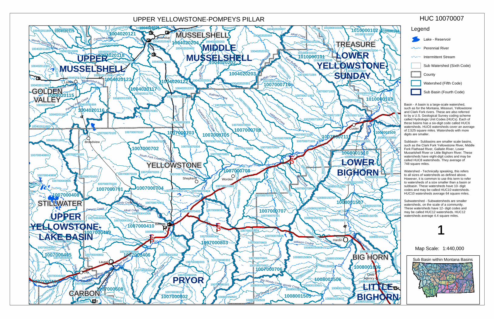
LegendLake - ReservoirPerennial RiverIntermittent StreamSub Watershed (Sixth Code)CountyWatershed (Fifth Code)Sub Basin (Fourth Code)

¹1:440,000Map Scale:

Sub Basin within Montana Basins

UPPER YELLOWSTONE-POMPEYS PILLAR 10070007HUC

Basin - A basin is a large-scale watershed,such as for the Montana, Missouri, Yellowstoneand Clark Fork rivers. These are also referredto by a U.S. Geological Survey coding schemecalled Hydrologic Unit Codes (HUCs). Each ofthese basins has a six-digit code called HUC6watersheds. HUC6 watersheds cover an averageof 2,525 square miles. Watersheds with moredigits are smaller. Subbasin - Subbasins are smaller scale basins,such as the Clark Fork Yellowstone River, MiddleFork Flathead River, Gallatin River, LowerMusselshell River or Little Bighorn River. Thesewatersheds have eight-digit codes and may becalled HUC8 watersheds. They average of748 square miles.Watershed - Technically speaking, this refersto all sizes of watersheds as defined above.However, it is common to use this term to referto watersheds of a size smaller than a basin orsubbasin. These watersheds have 10- digitcodes and may be called HUC10 watersheds.HUC10 watersheds average 64 square miles.Subwatershed - Subwatersheds are smallerwatersheds, on the scale of a community.These watersheds have 12- digit codes andmay be called HUC12 watersheds. HUC12watersheds average 4.4 square miles.