10 years of belarusian scientific studies in … years of belarusian scientific studies in the...
TRANSCRIPT
1
10 YEARS OF BELARUSIAN SCIENTIFIC STUDIES IN THE ANTARCTIC
Special report prepared for the SCAR Delegates’ Meeting, Kuala Lumpur, August 2016. 1 This report reviews the past decade of Belarusian scientific studies in Antarctica since the first Belarusian Antarctic Expedition in 2007. It is divided into two sections. The first section provides background on the establishment of the Belarusian Antarctic Station in Enderby Land, Eastern Antarctica. The second section explains the scientific research strategy developed by the National Academy of Sciences of Belarus for the long-term study of processes in Antarctica and the Southern Ocean and of the geology, geophysics and biology (flora and fauna) of the region. 2 A short film with English-language commentary about the construction of the Belarusian Antarctic Station in the 2015-2016 Antarctic season can be found using the following link: https://drive.google.com/file/d/0BxT1ofEX2SAqUmVIaWp3YmFWU2c/view?pref=2&pli=1
SECTION A: ESTABLISHMENT OF A BELARUSIAN ANTARCTIC
STATION (1) Scientific study of the prospective site
Ecological-geochemical investigations at Mount Vechernyaya, Enderby Land for preparation of a Comprehensive Environmental Evaluation of the Construction and Operation of a Belarusian Antarctic station 3 One of the main goals of the Belarusian Antarctic Programme in recent years has been the construction of the Belarusian Antarctic Station (BAS), equipped with up-to-date equipment for comprehensive scientific investigations and monitoring of the Antarctic environment. For the location of the station one of the oases in the western part of Enderby Land, Thala Hills, namely Mount Vechernyaya, was selected (Figure 1 below).
Figure 1 – Google map of Mount Vechernyaya with the location of the planned Belarusian Antarctic Station
Lazurnaya Bay
Terpeniya Bay

2
4 In accordance with the Protocol on Environmental Protection to the Antarctic Treaty, any activity in the Antarctic (research, tourism, construction and installation work, waste disposal, etc.) must be accompanied by an impact assessment at the planning stage. 5 The necessary on-site investigations having been carried out, a Draft and Final version of a Comprehensive Environmental Evaluation (CEE) were prepared by Belarusian specialists within the framework of the Belarusian National Programme on the Monitoring of the Earth’s polar areas and promotion of Arctic and Antarctic expeditions for the period 2011- 2015 and in accordance with the requirements of the Protocol on Environmental Protection to the Antarctic Treaty
(2) Methods of investigation and initial data collection and assessment 6 To define the reference state of the region, scientific publications addressing the history of investigations within Enderby Land, reference data, and reports of the Russian Antarctic Expedition related to Molodezhnaya Station and the Mount Vechernyaya field station operation, were collected and analysed. 7 For the impact assessment of the planned activity in the region of Mount Vechernyaya, different methods of comparative geographical analysis, modelling, mapping and the like were used. Impacts resulting from the construction and operation of the proposed station were subject to a separate assessment. Direct, indirect, and cumulative impacts were analysed. Two scenarios were taken into consideration to predict the BAS environmental impacts during the operation phase: seasonal (5-6 persons) and all-year-round (10-12 persons). 8 To assess the environmental conditions in the vicinity of the construction of the proposed BAS, the 4th Belarusian Antarctic Expedition (BAE) (2011-2012) and the 5th BAE (2012-2013) carried out environmental and geochemical studies in the area of identified for the BAS. Environmental and geochemical studies included sampling of snow, surface water, bottom sediments and soils. This research was aimed at establishing background concentrations of pollutants in the natural environment components prior to the construction of the BAS. 9 Sampling points were selected taking into account natural features as well as locations of possible sources of pollution. The sampling plan is given in Figure 2 below. In total during the 4th and 5th BAE 61 samples of snow, lake and sea water, ice, bottom sediment and soils sample were collected. 10 The estimation of emissions caused by stationary and mobile sources was carried out on the basis of emission factors according to Calculation methodology..., 2001; IPCC 2006; EMEP/EEA Atmospheric…, 2009. To assess the helicopter-caused noise impact, the NMSim v.3.0 model was applied. For ambient air impact assessment during the BAS operation, simulations of pollutant dispersion in atmosphere as generated by stationary sources were performed by use of the AERMOD model (Version 12345). The dilution rate of wastewater discharge into the sea was assessed by use of the Visual Plumes model of the U.S. Environmental Protection Agency.

3
Figure 2 – Sampling plan of snow, surface water, bottom sediments and soils at the Mount Vechernyaya field base location 11 To prevent negative environmental impacts during the construction and operational phases of the BAS measures for identifying impacts were designed and a Waste Management Programme and Environmental Monitoring Programme were developed.
(3) Preparation and submission of the Comprehensive Environmental Evaluation 12 Based on the scientific studies noted above, a Draft Comprehensive Evaluation for a Belarusian Antarctic Station at Mount Vechernyaya, Enderby Land, was prepared in 2013, taking into consideration the current state of knowledge of the Vechernyaya Mount environmental situation and projected impacts of the proposed station. The Draft CEE concluded that the scientific results to be gained as a result of the construction and operation of the proposed new research station at Mount Vechernyaya, Enderby Land, would outweigh the likely “more than minor or transitory impact” the station would have on the Antarctic environment in an area already highly impacted by earlier activities. The Draft CEE suggested that construction of the Belarusian station would significantly increase the capacity for research and the level of international cooperation in this region of Antarctica and that scope for co-operation in scientific efforts would be enhanced. 13 In January 2014 this Draft CEE was submitted to the Parties to the Antarctic Treaty, to the Treaty’s Committee for Environmental Protection (CEP), and to the Secretariat of the Antarctic Treaty. The Draft CEE was presentеd also by the Republic of Belarus at the XXXVII Antarctic Treaty Consultative Meeting (ATCM) held in Brasilia, Brazil, from 28 April to 7 May 2014 (see XXXVII ATCM / WP022).

4
14 Having analyzed the Draft CEE, the CEP duly informed the ATCM that the draft CEE substantially met the requirements of Article 3 of Annex I to the Protocol on Environmental Protection to the Antarctic Treaty (CEP Report XVII). Some comments also were made. 15 In 2014 the Final CEE was prepared taking into account the comments and suggestions made by Parties. Detailed responses to the comments are set out in Annex 4 to the Final CEE. 16 At the CEP XVIII meeting in June 2015 in Sofia, Bulgaria, in the course of the XXXVIII ATCM, the Committee welcomed the paper from Belarus. It noted that, in circulating the final CEE and presenting this paper, which detailed how it took into account the comments received, Belarus had met its obligation under Annex I of the Environmental Protocol. The Committee wished Belarus success in implementing the construction and operation of its station at Mount Vechernyaya, Enderby Land (Final Report of the XXXVIII ATCM, 2015). SECTION B: BELARUSIAN SCIENTIFIC RESEARCH IN ANTARCTICA 17 This section reviews the scientific research strategy developed by the National Academy of Sciences of Belarus for the long-term study of processes in Antarctica and the Southern Ocean. It describes the surface and atmosphere, geological and geophysical, and biological research undertaken by Belarusian scientists in Antarctica. 18 It should be noted that one of the most important goals of the Belarusian Antarctic science programme at present relates to scientific support for environmental protection in the region, including fulfillment of the international commitments of the Republic of Belarus in terms of the Antarctic Treaty and the Protocol on Environmental Protection to that Treaty. (B-1) Remote ground-based and satellite monitoring of snow surface, atmospheric aerosol and clouds in Antarctica 19 Today, Belarusian scientists are undertaking three types of background remote measurements in Antarctica:
Sun-radiometric measurements of column aerosol characteristics; Multi-wavelength lidar (laser locator) observations of vertical aerosol and cloud
structure; and, spectral radiometer measurements of snow surface parameters.
20 Integration of the new observation systems into international networks of environmental monitoring in Antarctica is now a principal interest of the Belarusian Antarctic programme.
Optical equipment for measuring parameters of atmospheric aerosol and earth surface in
Antarctica
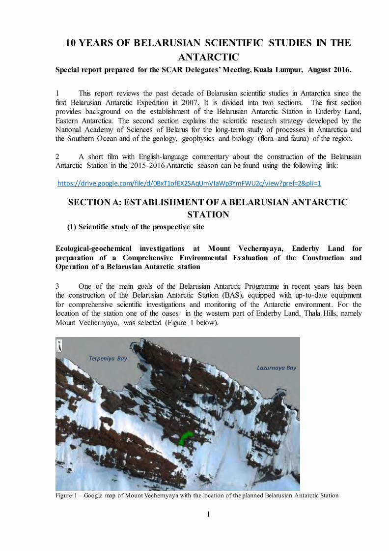
21 Remote monitoring of aerosol, clouds and underlying surface in Antarctic is performed by means of lidar and radiometric equipment, as well as through the analysis of satellite data. Photographs of equipment in use are given in Figure 3 below:
5
a) b)
c)
d)
Figure 3 - Optical measuring complex: a) - spectral radiometer for measurements of snow surface parameters (spectral albedometer); b) - sun spectral scanning radiometer СE-318; c – two-wavelength lidar; d) – multi-wavelength Raman polarization lidar Columnar aerosol parameters from Sun-radiometer spectral scanning observations
22 A spectral scanning polarizing photometer СE-318 (CIMEL) is used for radiometric measurements in Antarctica. The photometer measures the spectra of aerosol optical thickness, the angle dependences of sun-scattered radiation and its polarization characteristics in the spectral range 340 – 1020 nm. A photometer СE-318 (CIMEL) is the base instrument in the global radiometric network AERONET. The photometer performs two kinds of observations: sun-direct and sky-scattered radiation measurements. Sun-direct radiation is measured at the 7

6
wavelengths in the spectral range 340 – 1020 nm. Sky measurements are carried out at the wavelengths 440, 670, 870, and 1020 nm. The results of radiometric data processing are the aerosol parameters averaged over atmospheric layer: aerosol optical thickness (AOT), Angstrom parameter of AOT, water vapour content, aerosol particles size distribution, refractive index (real and imaginary parts), and phase function. 23 A new radiometric station was established during the Belarus Antarctic expedition on 25 December, 2008, in the coastal zone of Antarctica 14 km away from Russia’s “Molodezhnaya” Station (Figure 4). As the Belarus-French radiometric station called “Vechernaya Hill“(67S, 46E) (=Mount Vechernyaya – Ed), it was included in the AERONET global radiometer network.
Figure 4 – Initiation of radiometric measurements at the Antarctic station “Vechernaya Hill“, 25 December, 2008. Lidar sounding of the atmosphere in the Antarctic
24 The aim of the lidar measurements is investigation of the aerosol concentration profiles of the Antarctic atmosphere. Photographs of lidar sounding measurements and results of data processing are presented in Figure 5 below.
Figure 5 - Lidar measurements at the Belarusian Antarctic Station

7
Figure 6 - Height distribution of seasonal average backscatter aerosol coefficient βa (proportional to aerosol concentration) and its deviation δa, 1064 nm, “Mount Vechernyaya”, 2014 – 2015. Combined lidar and Sun-radiometer observations of aerosol characteristics and long range
aerosol transport
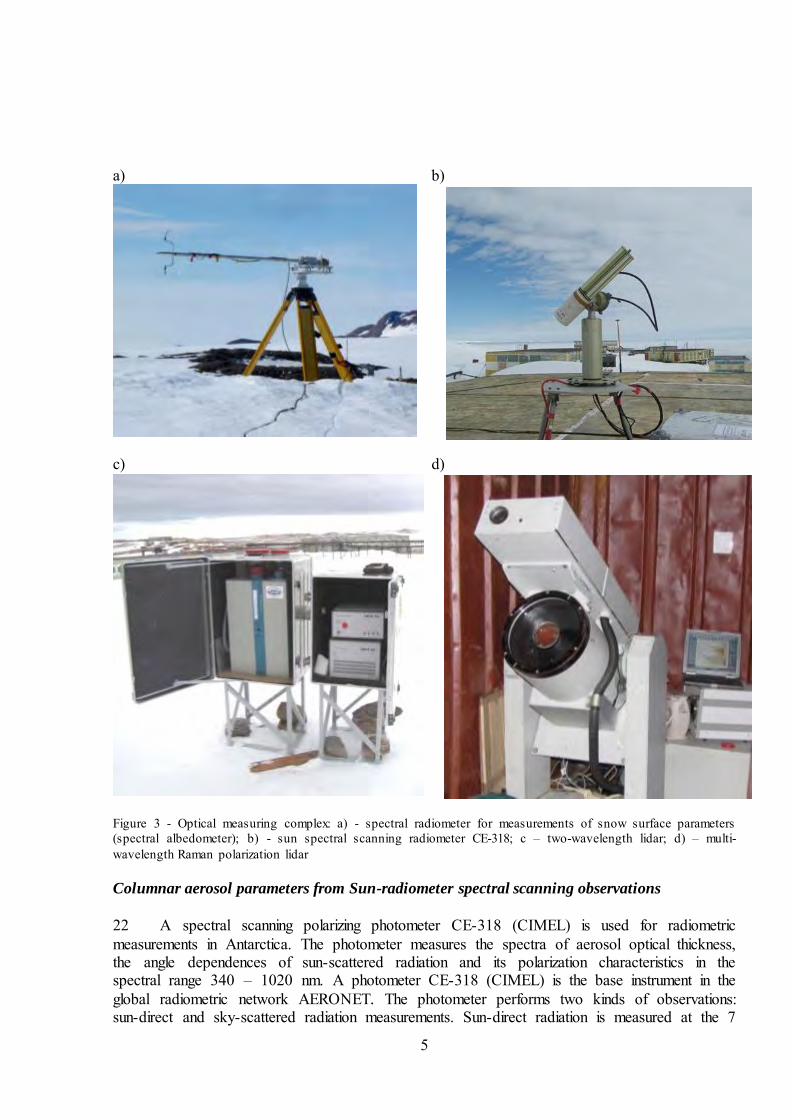
25 Coordinated multi-wavelength polarization lidar and spectral scanning radiometer measurements provide information on the altitude profiles of aerosol concentration and on microstructure parameters. Methods for complex lidar and radiometer sounding were developed in the Institute of Physics of the National Academy of Sciences of Belarus (NASB) in cooperation with the scientific teams of Goddard Space Flight Centre, USA, and the Laboratoire d’Optique Atmospherique, at the University of Science and Technology at Lille, France (Chaikovsky, 2002, 2004, 2008). The new technique was applied to study the process of aerosol long range transport in the Antarctic region. 26 During the 2013-2014 Antarctic season complex lidar and radiometric experiments were carried out for the first time. The altitude profiles of aerosol small (Fine) and large (Coarse) particle concentration were retrieved. Figure 7 shows the concentration profiles of the retrieved fine and coarse particles. The structure of the aerosol mode concentration profiles in the “Mount Vechernyaya“ region (67S, 46E) resulted from the large-scale transfer of smoke from the African continent. Figure 8 gives a map of fires in the South African region, based on satellite data spectrometer MODIS, and back trajectories, characterizing the transport via the air mass to the “Mount Vechernyaya“ region.
8
Figure 7 – Retrieved profiles of concentration of fine (smoke) and coarse aerosol fractions in the “Vechernaya Hill” region, 23 December, 2013. a) b)
Figure 8 – a) - map of fires in the South African region; b) –back trajectories of air mass transport, HYSPLIT model 27 Maps are constructed using the data of the MODIS radiometer, available on the official site of the mission: http://ladsweb.nascom.nasa.gov/data/search.html. This site allows one to find the appropriate satellite scene by the geographic coordinates and the date. The original file of the MODIS data in the HDF format is then processed by the SGSP code that produces a map of the retrieved parameters distribution in the H5 format as an output.
9
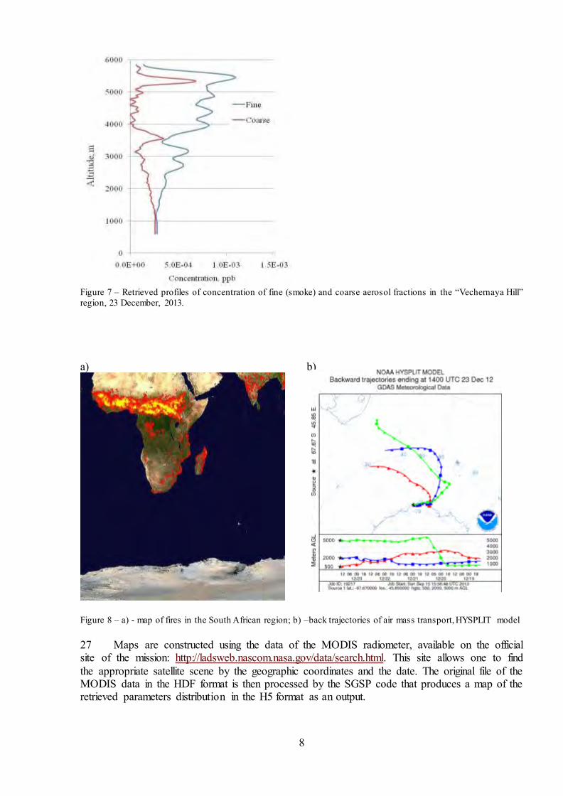
28 Below is the example of a map. The glacier in the region of the Ross Sea has a flat landscape and, therefore, is uniformly snow-covered. Its location is shown in Figure 9 below.
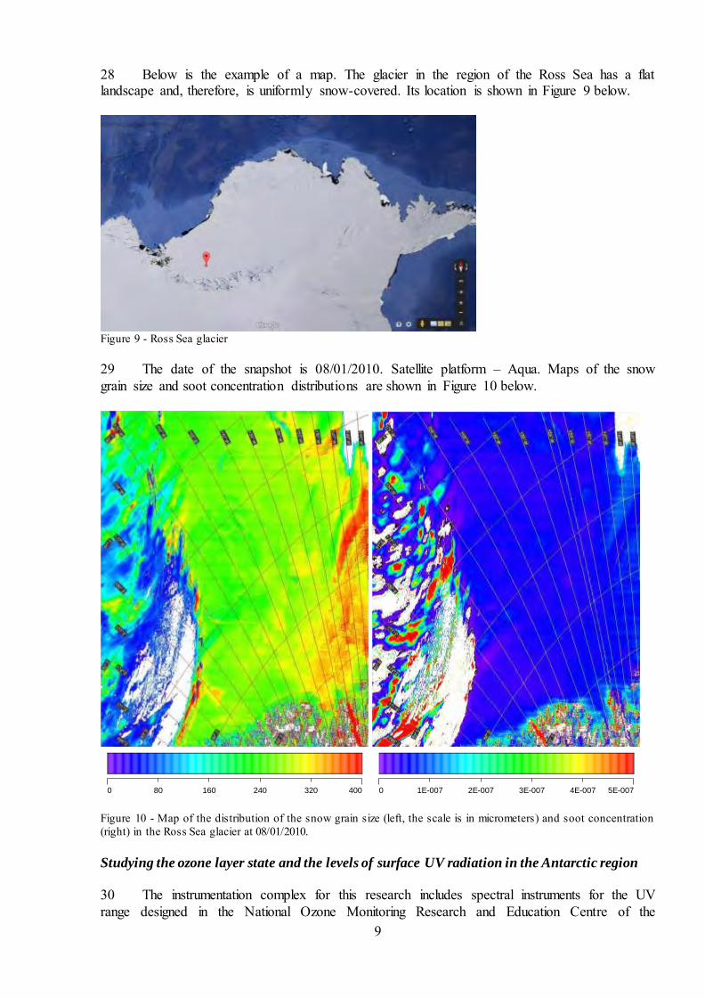
Figure 9 - Ross Sea glacier 29 The date of the snapshot is 08/01/2010. Satellite platform – Aqua. Maps of the snow grain size and soot concentration distributions are shown in Figure 10 below.
0 80 160 240 320 400
0 1E-007 2E-007 3E-007 4E-007 5E-007
Figure 10 - Map of the distribution of the snow grain size (left, the scale is in micrometers) and soot concentration (right) in the Ross Sea glacier at 08/01/2010. Studying the ozone layer state and the levels of surface UV radiation in the Antarctic region
30 The instrumentation complex for this research includes spectral instruments for the UV range designed in the National Ozone Monitoring Research and Education Centre of the

10
Belarusian State University (NOMREC BSU) for measuring solar UV radiation intensity and ozone and nitrogen dioxide concentrations (see Figure 11 below) namely: - (a) a modified filter ozonometer M124-M devised in the A.I. Voejkov Main Geophysical Observatory (Russian Federation) and modernized in the NOMREC BSU for explotation in polar regions; - (b) a spectro-radiometer PION-UV-II measuring spectral irradiance, levels and doses of biologically active solar surface UV radiation and total ozone in a vertical column of the atmosphere (TO); - (c) a filter radiometer PION-F, measuring a solar erythema dose of UV radiation and TO; - (d) a surface ozone concentration meter; and, - (e) an image spectrograph MARS-B with the multiaxial geometry of observations measuring the total amount and vertical distribution profiles of NO2. a) b)
c) d)
e)
Figure 11 - Instruments measuring solar UV radiation intensity, ozone and nitrogen oxide concentrations: a) filter ozonometer M124-M; b)spectroradiometer PION-UV-II; c) filter radiometer PION-F with a solar battery; d) surface ozone concentration meter on the basis of semiconductor gas sensor; e) image spectrograph MARS-B.
B-1-A Initial results of atmospheric scientific research

11
31 Despite the relatively short periods of experimental monitoring carried out by the seasonal BAEs, important results have been obtained. Some of these of a fundamental character are: (i) In the area of Mount Vechernyaya Station there is a clear diurnal trend of surface ozone concentrations. Moreover, unlike dependencies which are typical for the mid-latitudes of the Northern Hemisphere, ozone concentrations here drop in the daily hours and rise during the night, as shown in Figure 12 below:
Figure 12 - Diurnal variations of surface ozone concentration (area of the BAE, Mount Vechernyaya, 2007-2008) (ii) The maximum values of surface ozone concentrations amount to on average 15 ppb, and this coincides with the background concentrations registered in other "anthropogenically clean" regions of the globe. (iii) NO2 monitoring performed by the MARS-B image spectrograph with adjustable geometry for sighting and data processing, based on the MAX-DOAS technique, was conducted in Eastern Antarctica, near Russia’s Progress Station (located in the Larsemann Hills, S 69º22', E 76º23'), during the 59th Russian Antarctic Expedition (2013 – 2014). Note: The measurement data obtained during the period from 25.01.2014 to 28.02.2014 are shown in Figure 13, demonstrating the time course of differential slant column densities (DSCD) of NO2 and O3. It was found that a reduction of the amount of nitrogen dioxide in the upper atmosphere led to an increase of ozone.
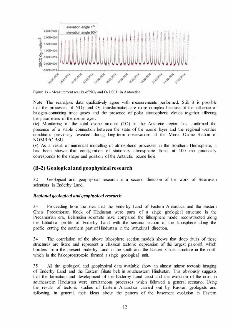
12
Figure 13 - Measurement results of NO2 and O3 DSCD in Antarctica Note: The reanalysis data qualitatively agree with measurements performed. Still, it is possible that the processes of NO2 and O3 transformation are more complex because of the influence of halogen-containing trace gases and the presence of polar stratospheric clouds together affecting the parameters of the ozone layer. (iv) Monitoring of the total ozone amount (TO) in the Antarctic region has confirmed the presence of a stable connection between the state of the ozone layer and the regional weather conditions previously revealed during long-term observations at the Minsk Ozone Station of NOMREC BSU. (v) As a result of numerical modelling of atmospheric processes in the Southern Hemisphere, it has been shown that configuration of stationary atmospheric fronts at 100 mb practically corresponds to the shape and position of the Antarctic ozone hole. (B-2) Geological and geophysical research 32 Geological and geophysical research is a second direction of the work of Belarusian scientists in Enderby Land. Regional geological and geophysical research
33 Proceeding from the idea that the Enderby Land of Eastern Antarctica and the Eastern Ghats Precambrian block of Hindustan were parts of a single geological structure in the Precambrian era, Belarusian scientists have compared the lithosphere model reconstructed along the latitudinal profile of Enderby Land with the seismic section of the lithosphere along the profile cutting the southern part of Hindustan in the latitudinal direction. 34 The correlation of the above lithosphere section models shows that deep faults of these structures are listric and represent a classical tectonic depression of the largest paleorift, which borders from the present Enderby Land in the south and the Eastern Ghats structure in the north which in the Paleoproterozoic formed a single geological unit. 35 All the geological and geophysical data available show an almost mirror tectonic imaging of Enderby Land and the Eastern Ghats belt in southeastern Hindustan. This obviously suggests that the formation and development of the Enderby Land crust and the evolution of the crust in southeastern Hindustan were simultaneous processes which followed a general scenario. Using the results of tectonic studies of Eastern Antarctica carried out by Russian geologists and following, in general, their ideas about the pattern of the basement evolution in Eastern

13
Antarctica, Belarusian researchers have compiled their own version of the Tectonic Map of the Enderby Land basement, which is shown in Figure 14 below. 36 As mentioned above, in the Archean Eon the future Indian and Eastern Antarctic Platforms formed a single whole and their cratonization took place in the Neoarchean (3.0-2.7 million years ago) with the formation of a large Ghats-Napier procraton, which became a Paleoarchean centre of old magmatism of the mafic-ultramafic series, granitization and granulite-facies metamorphism (according to Ye.V.Mikhalsky, stabilization took place 2.8-2.5 million years ago). The continental crust grew up by accretion around this old consolidation nucleus which evolution continued in the Meso- and Neo-Proterozoic.
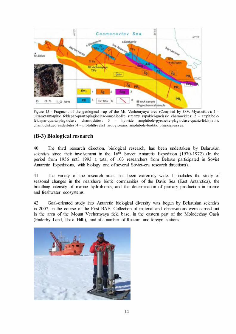
Figure 14 - Tectonic Map of the Enderby Land and its water area (compiled by R.G.Garetsky, G.I.Karatayev, I.V.Dankevich). Structures: 1 – Paleoarchean, 2 – Neoarchean, 3 – Paleoproterozoic; 4 – Neoproterozoic; 5 – deep faults; 6 - basement surface relief. 37 In the Late-Proterozoic (more exactly during the Neoproterozoic-Early Paleozoic activation), the Indo-Antarctic sub-latitudinal volcanic-plutonic belt of rift origin appeared and separated the Ghats-Napier granite-gneissic craton into two parts: the Eastern Ghats part in Hindustan and the Tyula-Napier one in Eastern Antarctica. Then this belt developed into a spreading zone due to active horizontal movements and consequently broke apart the Antarctic and Indian continents. Spreading relicts are now observed as a seismic belt around Antarctica. 38 The Krasin-Tyula belt of tectonic-magmatic activation, which crosses all three sub-latitudinal arcuate structures in Enderby Land, developed 0.7-0.55 million years ago in the process of the Hindustan and East Antarctica microcontinents moving apart relative to the spreading line along the corresponding transform faults in the region of Enderby Land. 39 Using the results of the detailed field geological and geophysical works and the subsequent laboratory studies of rock samples, as well as of the studies of the Precambrian basement in the vicinity of Molodezhnaya Station carried out in 1973 by American geologist E.S. Grew, who participated in the 18-th Soviet Antarctic Expedition (Grew, 1978; Grew, Manton, 1981), O.V. Myasnikov, a researcher of the Institute for Nature Management of the National Academy of Sciences of Belarus, compiled a geological map of Mount Vechernyaya area (see Figure 15 below).
14
Figure 15 - Fragment of the geological map of the Mt. Vechernyaya area (Compiled by O.V. Myasnikov): 1 – ultrametamorphic feldspar-quartz-plagioclase-amphibolite streamy rapakivi-gneissic charnockites; 2 – amphibole-feldspar-quartz-plagioclase charnockites; 3 – hybride amphibole-pyroxene-plagioclase-quartz-feldspathic charnockitized enderbites; 4 – protolith-relict twopyroxenic amphibole-biotitic plagiogneisses. (B-3) Biological research 40 The third research direction, biological research, has been undertaken by Belarusian scientists since their involvement in the 16th Soviet Antarctic Expedition (1970-1972) (In the period from 1956 until 1993 a total of 103 researchers from Belarus participated in Soviet Antarctic Expeditions, with biology one of several Soviet-era research directions). 41 The variety of the research areas has been extremely wide. It includes the study of seasonal changes in the nearshore biotic communities of the Davis Sea (East Antarctica), the breathing intensity of marine hydrobionts, and the determination of primary production in marine and freshwater ecosystems. 42 Goal-oriented study into Antarctic biological diversity was begun by Belarusian scientists in 2007, in the course of the First BAE. Collection of material and observations were carried out in the area of the Mount Vechernyaya field base, in the eastern part of the Molodezhny Oasis (Enderby Land, Thala Hills), and at a number of Russian and foreign stations.

15
Figure 16 – Belarusian Polar researchers in Antarctica 43 The current research programme includes botanical, zoological, microbiological, molecular-genetic, biochemical and other modern investigation methods as well as distant analysis methods, including employment of the Belarusian Space Apparatus (BSA). (See figure 16 above.) 44 Research on marine and freshwater flora and fauna is being conducted. Hundreds species of marine and freshwater algae and representatives of the zoobenthos have been identified, and mammals and birds are being studied. 45 Calorific content has been estimated for different marine flora and fauna representatives. The highest value has been determined in zooplankton. 46 Dozens of species of moss and lichen have been identified in terrestrial ecosystems. It is typical for species to accumulate photo-protective pigments, in particular melanins. It has been shown that proteins, including endogenous lectins of Antarctic lichen thalli, are involved in mechanisms of adaptation to extreme exposure and changing environmental conditions. 47 Collections of pure cultures of microorganisms have been created. To date more than 350 bacterial strains have been isolated from different biotopes. Petroleum-destructive bacteria of Deinococcus genus (strain A2-6) have been separated from Antarctic soil samples. 49 Studies of lithobiotic communities, complexes of microarthopods, free living proboscis worms and protists have been started. 48 Bottom-material samples (maximal size 1,75m) have been taken from Nizhnee Lake, located in the area of the Mount Vechernyaya field base. According to preliminary research findings, the age of the core fragment at a distance of 40-45 cm from the surface is about 5000 years. 49 It has been shown that some individual representatives of freshwater lake plankton can endure an ambient temperature of over 30°C. An analysis of the accumulation of radionuclides and heavy metal in some representatives of Antarctic flora and fauna is being carried out. Among the flora and fauna being studied are the earliest epibiotic insects, mosses and lichens.

16
INTERNATIONAL ANTARCTIC SCIENCE CONFERENCE BELARUS 2018 50 From 18-21 May 2016 Belarus hosted an international scientific conference on the theme of the Antarctic environment. The Conference, the second in a series, was organized by the Belarusian Centre of Polar Research and the National Academy of Sciences of Belarus. Information about this conference, which was attended by 87 representatives of 46 organisations from five countries, is contained in an Information Paper tabled at COMNAP XXVIII. 51 Inter alia, the Conference acknowledged the need to develop and introduce modern technologies for the sampling of air, soil, ice, water and living organisms in Antarctica with the aim of standardizing sampling systems and practice, thereby improving the accuracy of data available for monitoring the natural environment of the Antarctic. 52 Belarus will be hosting a Third International Scientific and Practical Conference on Antarctic science in the second half of 2018. Foreign participants are warmly invited. Further information will be available in due course.