10 right of way survey specifications...surveying tasks shall use them. the surveyor in responsible...
TRANSCRIPT

RIGHT OF WAY SURVEYS December 2019
© 2019 California Department of Transportation CALTRANS • SURVEYS MANUAL 10-1
10 Right of Way Survey Specifications
Table of Contents 10.1 Policy ............................................................................................................. 5 10.2 General Information ................................................................................. 7 10.3 Responsibilities ............................................................................................ 9 10.4 Initiation and Planning of a Right of Way Survey ................................ 13 10.5 Research ................................................................................................... 15
10.5-1 Record Data Search ......................................................................... 15 10.5-2 Sources of Record Data ................................................................... 15 10.5-3 Research - Sources of Record Data ............................................... 16
10.7 Notice of Intent to Survey / Right of Entry ............................................ 19 10.8 The Survey Request .................................................................................. 23
10.8-1 Field Package .................................................................................... 24 10.9 Right of Way Survey Fieldwork ............................................................... 25
10.9-1 Project Meeting ................................................................................. 25 10.9-2 Reconnaissance ................................................................................ 26 10.9-3 Marking the Search Map(s) ............................................................. 27 10.9-4 Right of Way Survey Methods .......................................................... 28 10.9-5 Accuracy ............................................................................................ 32
10.10 Survey Documentation ........................................................................... 33 10.10-1 Right of Way Survey Narrative Report ........................................ 33 10.10-2 Right of Way Survey Field Notes .................................................. 34 10.10-3 Monuments Search ....................................................................... 34 10.10-4 Monument Preservation and Pre-construction Corner Record(s)
…………………………………………………………………………………..36 10.10-5 Monument Preservation on Project Plans .................................. 38 10.10-6 Adjusted Field Observations and Final Survey Values ............. 38
10.11 Field Surveys Deliverable ........................................................................ 39 10.12 Utilities ........................................................................................................ 41 10.13 Boundary Analysis and Retracement of the Land-Net ...................... 43
10. 13-1 Corner Records and/or Records of Survey ................................ 43 10.14 Right of Way Flagging and Staking....................................................... 45
10.6 Field Review................................................. ............................................ 17
RIGHT OF WAY SURVEYS December 2019
© 2019 California Department of Transportation CALTRANS • SURVEYS MANUAL 10-2
10.14-2 Right of Way Flagging Procedures ............................................. 46 10.15 Right of Way Monumentation ............................................................... 47
10.15-1 Final Monumentation of Right of Way ........................................ 47 10.15-2 R/W Monumentation Procedures ............................................... 48 10.15-3 Monumentation Map (Record of Survey) ................................. 49 10.15-4 Monument Renewal or Restoration ............................................ 51
10.16 Requests by Adjoiners for Monumentation of Caltrans Right of Way Lines……………………………………………………………………………………53
10.16-1 Assignment of Cost ........................................................................ 54 10.17 Monumentation of the Intersection of an Adjoiner’s line with Caltrans’ R/W ……………………………………………………………………………………57 Appendix 10A: Glossary ...................................................................................... 58
10.14-1 Right of Way Flagging – Types of Lines ....................................... 45

RIGHT OF WAY SURVEYS December 2019
© 2019 California Department of Transportation CALTRANS • SURVEYS MANUAL 10-3
10 Right of Way Surveys
Right of Way (R/W) surveys are performed to gather data on existing property rights that affect the state highway system. This includes monuments, roadways, fencing, utilities, and any other evidence that make up the land-net0F
1. This information, in conjunction with existing land records and right of way requirements, is used to determine, delineate, appraise, acquire, demarcate, monument, and map Caltrans’ rights of way.
The R/W surveys specifications in this chapter are to be used for all Caltrans-involved transportation improvement projects, including special-funded projects. All surveyors performing Caltrans R/W surveying tasks shall use them. The surveyor in responsible charge will adhere to all relevant processes, workflows, and specifications stated in this chapter. Questions about this chapter should be directed to the Project Surveyor or their functional manager. Any deviation from this model requires advance written approval from the Functional Manager1F
2.
This chapter provides policies, general information, and procedures regarding the R/W surveys process. It is intended to describe a statewide model of responsibilities and workflow. It is not an instruction manual for the preparation of records of survey, corner records, or other land surveys products prepared by Caltrans. The project surveyor in responsible charge must be knowledgeable in the appropriate laws and regulations concerning their preparation.
The policies and procedures for acquiring and disposing of real property rights, such as the preparation of deeds and Right of Way Appraisal, Record, Relinquishment, and Vacation maps, are covered in Chapter 6 of the Caltrans Right of Way Manual, and are not addressed in this chapter.
1A land-net survey is a cadastral survey of existing property rights. It includes evidence of rights such as fee title lines and recorded, prescriptive, blanket or floating easements. It also may identify conflicts between title lines, or between title lines and lines of occupation. 2 See Chapter 1.5, Project Management for the role of the functional manager.

RIGHT OF WAY SURVEYS December 2019
© 2019 California Department of Transportation CALTRANS • SURVEYS MANUAL 10-4
This Page Left Intentionally Blank

RIGHT OF WAY SURVEYS December 2019
© 2019 California Department of Transportation CALTRANS • SURVEYS MANUAL 10-5
10.1 Policy Caltrans policy regarding R/W surveys, as defined by this chapter, is to provide, in a timely manner, complete and accurate R/W boundary information.
It is also Caltrans policy that all R/W surveys shall be based upon and conform to the other requirements in the Caltrans Surveys Manual, and Chapter 6 of the Caltrans Right of Way Manual. It is Caltrans policy to adhere to all laws pertaining to land surveying.
These laws2F
3 include, but are not limited to:
• The Business and Professions Code §§ 8700 – 8805 (The Professional Land Surveyors Act)
• The Public Resources Code §§ 8801 - 8902 • The Civil Code §§ 846.5, 1066 – 1073, 1092 – 1093, 1104 –
1134 • The Government Code §§ 6103, 66124, 66428, 66246.5 • The Code of Civil Procedure, §§ 1230.010 – 1230.070,
2077 • The Streets and Highways Code §§ 73, 83, 128, 732.5, et
al • The Harbors and Navigation Code §§ 100 – 107 • California Code of Regulations §§ 400 – 474.5 (The
Board Rules for Professional Engineers and Land Surveyors)
3 California laws can be found at: http://leginfo.legislature.ca.gov

RIGHT OF WAY SURVEYS December 2019
© 2019 California Department of Transportation CALTRANS • SURVEYS MANUAL 10-6
This Page Left Intentionally Blank
RIGHT OF WAY SURVEYS December 2019
© 2019 California Department of Transportation CALTRANS • SURVEYS MANUAL 10-7
10.2 General Information R/W surveys are used to help define and demarcate the boundaries of the Caltrans R/W in relation to existing property boundaries. R/W surveys are not intended to monument boundaries of the adjoining property owners, other than the common boundary between Caltrans R/W and the adjoining property.; There may be situations where it is necessary to define the adjoining owners’ property line for internal purposes, such as determining the intersection of the adjoiner’s property line with existing R/W, establishing boundaries for the purpose of preparing legal descriptions, or determining the area of adjoining property.
The primary purpose of a R/W survey is to provide sufficient survey data necessary for the proper retracement of the land net.
The retracement of the land net may be used for the following: • Creation of appraisal maps • Legal descriptions and deed preparation • Negotiation purposes • Condemnation purposes • R/W flagging and R/W staking • Monumentation • Land net and control-net perpetuation • Encroachment and trespass resolution • Help establish project limits • Tort cases
R/W surveys are an integral element of Caltrans acquisition and disposal of property rights.
These property rights may include: • Parcels and/or interest in parcels acquired for Caltrans transportation facilities, including off-site parcels such as mitigation sites • Street or highway operating R/W to be relinquished • Superseded R/W to be vacated • Lands that have been declared “excess” (no longer needed by Caltrans)

RIGHT OF WAY SURVEYS December 2019
© 2019 California Department of Transportation CALTRANS • SURVEYS MANUAL 10-8
This Page Left Intentionally Blank

RIGHT OF WAY SURVEYS December 2019
© 2019 California Department of Transportation CALTRANS • SURVEYS MANUAL 10-9
10.3 Responsibilities Teamwork is vital for a successful R/W survey project and requires close cooperation between the Project Surveyor, the Design Engineer, Land Surveys (Surveys and Right of Way Engineering), the Party Chief, and Right of Way. Each party must maintain the lines of communication with others throughout the project to ensure timely completion. It is the responsibility of all involved in a R/W Survey project to adhere to all relevant laws and policies.
Project Surveyor For the purpose of this chapter, the term “Project Surveyor” refers to that person in responsible charge of preparing, signing and sealing any record of survey or corner records depicting the project land-net. The project surveyor, in conjunction with the project engineer and party chief, is responsible for the preservation, referencing, or replacement3F
4 of all survey monuments within the project limits.
It is the responsibility of the Project Surveyor to:
• Create and maintain a R/W survey project file that will contain all data related to a R/W survey
• Identify properties that are likely to be affected based on approximate R/W requirements obtained from the Design Engineer
• Perform or oversee a record data search that will adequately cover the extent of R/W required for the project
• Submit survey requests to Surveys for R/W survey fieldwork • Coordinate with other functional units as necessary • Ensure, in conjunction with R/W, that adjacent owners have been
notified of Caltrans’ intent to survey the area. • Review the R/W survey data for completeness
4 Street & Highways Code §732.5

RIGHT OF WAY SURVEYS December 2019
© 2019 California Department of Transportation CALTRANS • SURVEYS MANUAL 10-10
• To identify to the Design Engineer the existing monuments that will be preserved or replaced, and new monuments to be set, for inclusion in the contract plans
• Perform boundary analysis to reconcile field data with the record data for final land-net values
• Prepare and submit to the County Surveyor, in the counties in which the project lies, all mapping required by the PLS Act.
• Ensure that all maps, deeds, field notes, and adjustments of field data are permanently documented or preserved at the completion of each project
Party Chief The Party Chief directs the work of a survey field crew. It is the responsibility of the Party Chief to:
• Search, recover, locate, describe, and document land-net monuments.
• Ensure that the accuracy standards stated in Section 10.9-4 - Right of Way Surveys Methods - of this chapter and Chapter 5, “Accuracy Classifications and Standards” are met.
• Prepare survey field notes for documentation of the R/W survey work.
• Identify monuments that need to be preserved, referenced, or replaced per PLS Act §8771.
• Flag existing and proposed rights of way for preliminary environmental and engineering studies, or to aid in property appraisals and acquisitions.4F
5 • Set monuments required for new rights of way.
5 See Section 10-14

RIGHT OF WAY SURVEYS December 2019
© 2019 California Department of Transportation CALTRANS • SURVEYS MANUAL 10-11
Project Engineer
The Project Engineer is in responsible charge of preparation of the project plans and specifications.
It is the responsibility of the Project Engineer to:
• Communicate with Surveys as early in the project as possible • Verify that all engineering plans are prepared using the same
datum as the control, topographic, and right of way surveys prepared for the project, according to Chapter 4 of this manual and Appendix QQ of the Project Development Procedures Manual
• Verify that all monuments that have been identified by Surveys as needing to be set, preserved or replaced are identified on the project contract plans per P.E. Act 6730.2(c) and PLS Act §8771(d).

RIGHT OF WAY SURVEYS December 2019
© 2019 California Department of Transportation CALTRANS • SURVEYS MANUAL 10-12
This Page Left Intentionally Blank

RIGHT OF WAY SURVEYS December 2019
© 2019 California Department of Transportation CALTRANS • SURVEYS MANUAL 10-13
10.4 Initiation and Planning of a Right of Way Survey Planning R/W surveys should establish or re-establish all property rights and titles that could affect existing Caltrans rights of way and establish a sufficient land-net for the determination of future rights of way lines. The planning for R/W surveys should include all phases of the R/W survey, from initial research through final monumentation and the filing of all maps required by law and Caltrans policy. Key steps in the R/W Surveys process are:
• Research the existing horizontal control networks. • Research Record land-net data. • Field Surveys, including safety considerations. • Preparation of pre-construction Corner Records or Record of Survey • Support for R/W appraisals and acquisitions. • Monument preservation and setting new monuments. • Final Corner Records or Record of Survey.

RIGHT OF WAY SURVEYS December 2019
© 2019 California Department of Transportation CALTRANS • SURVEYS MANUAL 10-14
This Page Left Intentionally Blank

RIGHT OF WAY SURVEYS December 2019
© 2019 California Department of Transportation CALTRANS • SURVEYS MANUAL 10-15
10.5 Research The Project Surveyor will coordinate a thorough review of all pertinent land and survey records. Thorough research of relevant real property and land survey records forms the foundation of a R/W survey. Overall survey efficiency and quality of deliverables will in part be determined by the quality of the research. During the planning phase of the project, the Project Surveyor will meet with assigned staff to discuss the overall scope of the project and specific project requirements.
10.5-1 Record Data Search The record data search is the first action taken in the monument recovery process and provides the necessary survey and land ownership data required for the field survey and for analysis and mapping of the recovered land-net information. The search should begin as early in a R/W survey project as possible. The goal of the record data search is to meet three primary objectives:
• Recover geodetic control-net information. • Recover record land-net information. • Recover all other information necessary for the R/W survey.
10.5-2 Sources of Record Data Real Property and land survey records are available in Caltrans files, and from other government agencies, utility companies, title companies, and other public/private entities. The research for a R/W survey should be part of the research for the overall transportation improvement project.
The Project Surveyor should maintain a record of contacts for property research efforts. Each record in the file should contain the name of the agency or company, address, phone numbers, e-mail addresses, and the names of the contacts, as needed.
RIGHT OF WAY SURVEYS December 2019
© 2019 California Department of Transportation CALTRANS • SURVEYS MANUAL 10-16
10.5-3 Research - Sources of Record Data Source of Records Record Type
Federal Agencies: including but not limited to, United States Bureau of Land Management, Bureau of Indian Affairs, United States Forest Service, The National Geodetic Survey, and United States Geological Survey.
Federal land boundaries, current and historical land ownership and transaction records, survey data on patented lands (plat maps and field notes) and control data.
State of California Agencies: including but not limited to, Caltrans, State Lands Commission, Department of Water Resources, High Speed Rail Authority, Department of Parks and Recreation, and Department of Forestry and Fire Protection.
Field-notes / field-ties, aerial photographs, Monumentation Maps, Record of Survey maps, State Highway maps, Relinquishment & Vacation maps, Right of Way Record maps, Survey Control maps, and Control data.
Local Agencies: County, City, other local districts. The County Agencies (County Surveyor’s Office, Recorder’s Office, etc.) are the official repositories for the majority of land ownership records.
County Surveyor’s Office: Tract, Parcel and Record of Survey maps, Rancho maps, Certificates of Corrections, Corner Records, Lot Line Adjustments, Control, County Survey tie/alignment notes, private surveyor notes, City/County boundary information and Assessor’s maps and rolls, and unrecorded maps. Flood and Planning department’s records: The County Surveyor’s office may also maintain land and survey records from Federal, State and other local agencies, utility companies, railroads, etc., that lie within their boundary. County Recorder’s Office: - Assessor’s maps and rolls, deeds, historical records.
Utilities Utilities: Maps, deeds, field notes, and franchise agreements.
Private Civil Engineering and Land Surveying Companies
Companies maintain research folders, maps and field notes pertaining to projects done by them. This is a good place to go when you find a tagged monument with no record of it having been set. They may also have records of current and past survey work done by other surveyors.
Title Companies Maps, deeds and records affecting title and its history. This is another source for deed information other than the county recorder’s office.
Railroads Railroad maps, survey notes and deeds pertaining to railroad right of ways and adjoiners.
Historical Societies Historical maps and documents pertaining to long past ownerships.

RIGHT OF WAY SURVEYS December 2019
© 2019 California Department of Transportation CALTRANS • SURVEYS MANUAL 10-17
10.6 Field Review
It is recommended that the Project Surveyor field review the project site in order to have an overview of the project area and an understanding of the terrain and other issues that could affect the field work. This enables the Project Surveyor to have a clear idea of the potential R/W survey issues for the project. The field review should be conducted with at least one other staff member for safety.
If the field review is not performed prior to the field survey, the Project Surveyor should accompany the survey party when the Party Chief performs the site reconnaissance (See 10-9.2). The field review should include:
• Visual review of the project area. • Evaluating potential access problems. • Evaluating potentially affected parcels and easements. • Evaluating potentially affected utilities. • Conducting an initial search of record land-net monuments. • Evaluating which monuments may be destroyed. • Determining areas where unwritten rights may exist (i.e., water
boundaries). • Evaluating the project area for safety concerns. • Any other factors that may affect the R/W survey.

RIGHT OF WAY SURVEYS December 2019
© 2019 California Department of Transportation CALTRANS • SURVEYS MANUAL 10-18
This Page Left Intentionally Blank

RIGHT OF WAY SURVEYS December 2019
© 2019 California Department of Transportation CALTRANS • SURVEYS MANUAL 10-19
10.7 Notice of Intent to Survey / Right of Entry It is Caltrans policy that owners and tenants of property will be notified of Caltrans intent to perform a survey in advance. This will be accomplished by mailing Survey Notification Cards (Exhibit 10A) and/or by placing Survey Notification Door Hangers (Exhibit 10B) on the front door of the main structure on the property.
A Land Surveyor has the legal right of access and entry upon real property to perform a survey. This right is vested in Section 8774 of The PLS Act and Section 846.5 of the Civil Code.
Civil Code Section 846.5 : (a) The right of entry upon or to real property to investigate and utilize boundary evidence, and to perform surveys, is a right of persons legally authorized to practice land surveying and it shall be the responsibility of the owner or tenant who owns or controls property to provide reasonable access without undue delay. The right of entry is not contingent upon the provision of prior notice to the owner or tenant. However, the owner or tenant shall be notified of the proposed time of entry where practicable5F
6.
(b) The requirements of subdivision (a) do not apply to monumentswithin access-controlled portions of freeways.
(c) When required for a property survey, monuments within afreeway right-of-way shall be referenced to usable points outsidethe access control line by the agency having jurisdiction over thefreeway when requested in writing by the registered civil engineeror licensed land surveyor who is to perform the property survey. Thework shall be done within a reasonable time period by the agencyin direct cooperation with the engineer or surveyor and at nocharge to him.
The party chief will make a reasonable effort to contact the owner or tenant of any property before entering to conduct any field surveys. If the owner/tenant requires special conditions for entry, the party chief will make a reasonable effort to comply with the conditions.
6 PLS Act §8774 uses the same language as Civil Code §846.5(a)

RIGHT OF WAY SURVEYS December 2019
© 2019 California Department of Transportation CALTRANS • SURVEYS MANUAL 10-20
Survey Notification Card – Exhibit 10A

RIGHT OF WAY SURVEYS December 2019
© 2019 California Department of Transportation CALTRANS • SURVEYS MANUAL 10-21
Survey Notification Door Hanger – Exhibit 10B

RIGHT OF WAY SURVEYS December 2019
© 2019 California Department of Transportation CALTRANS • SURVEYS MANUAL 10-22
This Page Left Intentionally Blank

RIGHT OF WAY SURVEYS December 2019
© 2019 California Department of Transportation CALTRANS • SURVEYS MANUAL 10-23
10.8 The Survey Request After performing the initial research, the Project Surveyor will prepare a survey request for field work. The request will include:
• Copies of existing right of way maps, with approximate project limits.
• A list of search monuments, with descriptions and map references. Coordinates provided as needed. Alternate monuments should be identified if a preferred monument is not recovered.
• Copies of all recorded maps within project limits, including records of surveys, subdivision maps, corner records, assessor’s maps, and county surveyor field notes. The monuments on the search list will be identified on the appropriate record map.
• When recorded maps have substantial differences in the bearings or distances of common lines, the project surveyor may prepare a search map, which rotates the recorded maps to a common datum to help establish search coordinates. This map is recommended where terrain or distances make simple searches difficult.
• A written explanation of important monuments and preferred alternates.
• The Project Surveyor will keep a duplicate file of the survey request and attachments.

RIGHT OF WAY SURVEYS December 2019
© 2019 California Department of Transportation CALTRANS • SURVEYS MANUAL 10-24
10.8-1 Field Package The survey request and additional materials will then be assembled into a field package. The field package will be used by the Party Chief to successfully complete a R/W survey project
A typical field package for a R/W survey includes: • The Survey Request and accompanying materials
• A copy of Project Control Form 4.1 –see http://cefs2.dot.ca.gov/ Form SUR-41
• A list of monuments previously located as part of Control or Engineering surveys6F
7, including coordinates, corner records or other monument descriptions, and copies of field notes
• List of search monuments by number, with coordinates as needed
• Right of entry information, conditions and permits, and accompanying materials.
A completed field package should be well organized and arranged in a manner that is most advantageous for use by the Party Chief. It is important that the data and records be clearly labeled and easy to find. The Party Chief will perform a thorough review of the field package and determine if it is clear and complete.
7 See Chapter 9.4-3 and 9.4-4.
RIGHT OF WAY SURVEYS December 2019
© 2019 California Department of Transportation CALTRANS • SURVEYS MANUAL 10-25
10.9 Right of Way Survey Fieldwork The R/W survey fieldwork should be coordinated with other project surveying activities. These activities include performing control, photogrammetry, design, and construction surveys.
Scheduling R/W survey fieldwork to occur early in the process and synchronizing it with other transportation improvement project survey activities allows for the early referencing of control-net and land-net corners, so that they can be preserved, referenced, or replaced as needed. The practical advantage of coordinating all transportation improvement project land surveying activities is to save time by minimizing the number of trips to the field and to allow for an adjustment of the majority of survey data at one time.
10.9-1 Project Meeting The Project Surveyor shall meet with the Party Chief to review the R/W survey and the field package. The primary objective of this meeting is to acquaint the field staff with the overall scope and purpose of the R/W survey. The field package shall be thoroughly reviewed with emphasis placed on specific land-net corners to recover and preserve. This meeting will also serve to establish the lines of communication for the R/W survey project.

RIGHT OF WAY SURVEYS December 2019
© 2019 California Department of Transportation CALTRANS • SURVEYS MANUAL 10-26
10.9-2 Reconnaissance The Party Chief will perform an initial reconnaissance of the project. This effort shall be performed in a diligent and thorough manner to ensure that any existing monuments are recovered and that the land-net can be retraced.
The reconnaissance effort shall include: • Evaluating the overall safety considerations of the
project site, monument accessibility concerns, traffic control needs, and free space (see Chapter 2.6-1).
• Noting monuments that may require traffic control to be safely accessed.
• Marking the location, condition, and description of the existing control-net.
• Evaluating the need for supplemental survey control monuments for making field ties and for other survey work associated with the overall transportation improvement project.

RIGHT OF WAY SURVEYS December 2019
© 2019 California Department of Transportation CALTRANS • SURVEYS MANUAL 10-27
10.9-3 Marking the Search Map(s) The Party Chief shall mark the appropriate record or search map(s) with complete information to show the results of the recon effort including areas where unwritten rights may exist. This information shall be placed on the appropriate map(s) in a clear and legible manner. Note: The search map(s) augment but are not a substitute for the R/W survey field notes.
The following are abbreviations for marking the search map:
BLC Block Corner PN Pavement Nail CC Closing Corner PRH Project Control CLH Center Line Monument QC Quarter Corner CHC Concrete Pin Monument RNCH Rancho Corner DIS Disturbed REB Rebar FD Found Monument REFR Reference Point FE Fence RR Rail Road Spike FRLC Fractional Lot Corner RW R/W Monument HH Hand Hole Monument RWH Redwood Hub IP Iron Pipe SC Section Corner LOT Lot Corner SNF Searched – Not Found MC Meander Corner SUH Supplemental Control PKN PK Nail TC Township Corner PLS PLS Corner, Other TRC Tract Corner PMC Parcel Corner WC Witness Corner

RIGHT OF WAY SURVEYS December 2019
© 2019 California Department of Transportation CALTRANS • SURVEYS MANUAL 10-28
10.9-4 Right of Way Survey Methods The Party Chief will conduct the surveying of the existing rights of way and land-net. The survey must be based on project and supplemental control monuments set according to Chapter 9.4 of this manual, and use the same datum, datum tag, and epoch as used for the project control monuments and engineering surveys.
All found monuments must be included in a final network adjustment. Monuments must be tied to at least two other monuments when using total stations, or must be occupied at least twice when using GNSS equipment.
It is highly recommended that right of way surveys be conducted simultaneously with control and engineering surveys (see Chapters 9 and 11). Including land-net monuments in the control network ensures that all surveys are based on the same project coordinates. It allows for the accurate calculation of existing rights of way for projects that may not have new acquisitions and establishes coordinate values for future search efforts. It also results in a more densified network of supplemental control monuments. During engineering surveys, found monuments and topographical features can be accurately mapped together, and the relationship noted on the field notes.
If monuments that are recovered appear to conflict with features such as fences, driveways, or drainage structures, the Party Chief will note the issues. If the conflicting topographical features have not been located by prior surveys, the survey party will locate them using the standards for engineering surveys7F
8.
The Party chief may use total station or GNNS methods to conduct a R/W Survey. The surveying method shall adhere to the requirements in other chapters of this manual including:
• Chapter 7 “Total Station Survey System (TSSS) Survey Specifications”.
8 See Chapter 11

RIGHT OF WAY SURVEYS December 2019
© 2019 California Department of Transportation CALTRANS • SURVEYS MANUAL 10-29
• Chapter 6 “Global Positioning System (GPS) SurveySpecifications”.
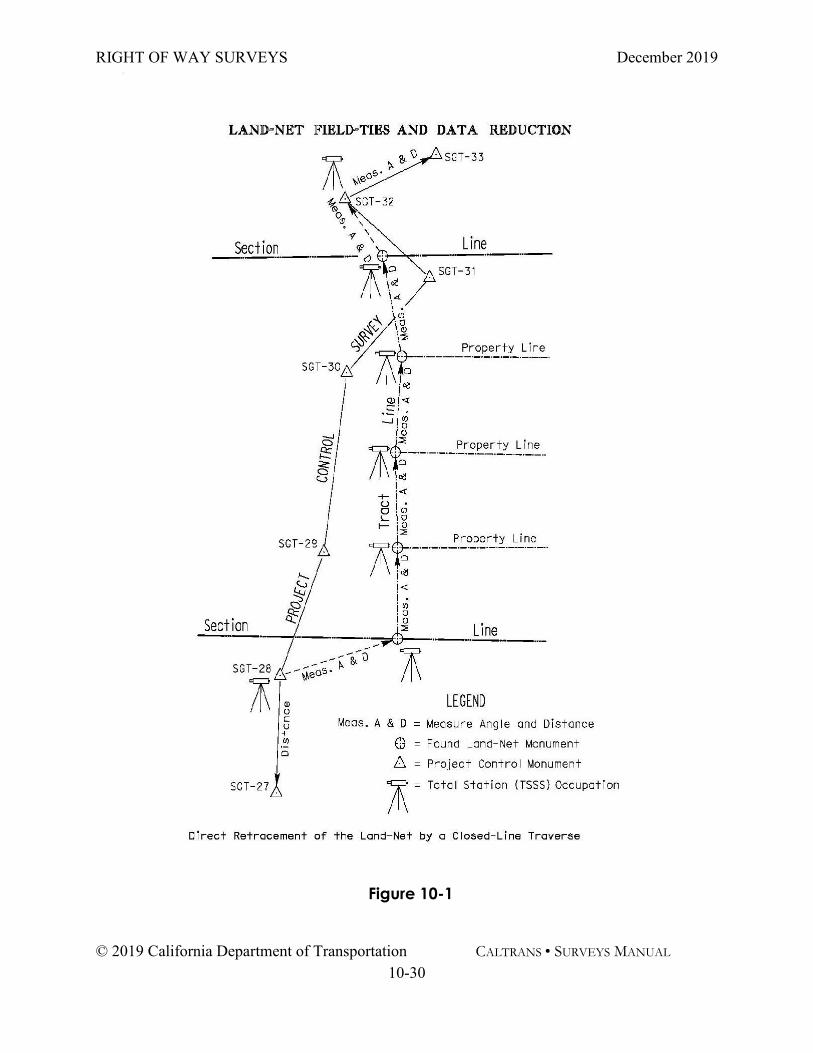
Total station field ties of the recovered monuments can be made in the form of either a “direct” or “indirect” retracement. (See Figures 10-1 & 10-2 and Appendix 10-A “Glossary”) The direct retracement and indirect retracement methods can both be used in the same total station R/W survey.
GNSS field ties of the recovered monuments can be made by using static, fast static, or Real Time Kinematic (RTK) methods as specified in Chapter 6, GNSS Survey Specifications. A real time network (RTN) may be used if the procedures are followed for an RTK survey as shown in Chapter 6.
For R/W Surveys using RTK/PPK methods the following additional specification is required:
• Each monument must be occupied twice, each occupationusing a different base station.
• Monuments must be occupied at least two hours apart toestablish a different satellite geometry. If observed ondifferent days, the second observation must begin at leasttwo hours different from the time of the original.
For adjacent monuments with coordinates produced from RTK methods, the combined positional accuracy of the two monuments shall meet or exceed the Third Order precisional ratio of 1:10,000. In this instance, the precisional ratio is calculated from the 95% positional accuracies of each of the monument’s resultant RTK produced coordinates and the distance between the monuments by the equation:
Y = (Distance)÷√(A² + B²)
Where A is the positional accuracy at the first station and B is the positional accuracy at the second station.
1:Y is the resultant precisional ratio, where Y shall be greater than or equal to 10,000.
RIGHT OF WAY SURVEYS December 2019
© 2019 California Department of Transportation CALTRANS • SURVEYS MANUAL 10-30
Figure 10-1

RIGHT OF WAY SURVEYS December 2019
© 2019 California Department of Transportation CALTRANS • SURVEYS MANUAL 10-31
Figure 10-2

RIGHT OF WAY SURVEYS December 2019
© 2019 California Department of Transportation CALTRANS • SURVEYS MANUAL 10-32
10.9-5 Accuracy The accuracy of the R/W survey shall conform to the requirements stated in Chapter 5, “Accuracy Classifications and Standards” along with the criteria for PPK produced values stated in Section 10.10-4. In no case will surveys be performed at less than 1:10,000 relative accuracy and 0.07 foot (2 cm) local positional accuracy, according to Chapter 5 of this manual.
Areas where unwritten rights may exist will be surveyed to properly locate conspicuous features and their limits. These areas will be surveyed to General Order standards as defined in Chapter 5 of this manual.

RIGHT OF WAY SURVEYS December 2019
© 2019 California Department of Transportation CALTRANS • SURVEYS MANUAL 10-33
10.10 Survey Documentation Documentation of the R/W Survey is accomplished by proper and timely completion of the R/W survey job file.
The following shall be included in the R/W survey job file:
•R/W survey narrative report • R/W survey field notes • Monument descriptions and marked search map(s) • All Corner Records and/or Records of Survey • The adjusted field observations • The final survey values
10.10-1 Right of Way Survey Narrative Report The R/W survey narrative report is an overall description of the project and project surveying related issues. It should be written in a manner that will allow for a subsequent surveyor to easily determine the reason for the survey, how the survey was conducted, the control that was held, and any problems encountered.
The Party Chief shall complete a R/W survey narrative. The narrative report shall contain:
• Project name • Survey limits • Purpose • Date • Datum, datum tag, epochs, and units • The control held for the survey • Personnel • Equipment used • The surveying methods used • Problems encountered • Signature and Seal of the Party Chief • Any other pertinent information

RIGHT OF WAY SURVEYS December 2019
© 2019 California Department of Transportation CALTRANS • SURVEYS MANUAL 10-34
10.10-2 Right of Way Survey Field Notes The Party Chief shall produce field notes that are a combination of electronically recorded measurement data and hand-written or computer-generated notes that together represent an accurate, clear, complete, and concise record of the R/W survey. The final quality of all record maps and documents depends on the quality of the information and data contained in these notes. The Party Chief should keep in mind that survey field notes are of such vital importance that they are at times called into review by courts. Field notes should include all evidence, even if it may disagree with record data.
The field notes shall contain the following:
• A Project Location Sketch that contains the location of the R/Wsurvey site relative to major roadways and/or landmarks andthe approximate location of control-net relative to the projectsite.
• Monument location drawings showing the monument pointnames, numbers, description, character and any ties oraccessories.
• A Recovery List summarizing all monuments found, not found, orset. The list should include point names, numbers, anddescriptions.
• Hard copies of raw survey data.
10.10-3 Monuments Search When searching for monuments, the survey party should use all available evidence - record, physical, and sometimes testimonial. Most record monuments may be located by their relationship to topographical features. Street intersections, curve points, and fence corners are the most likely location of survey monuments. Many monuments can be readily found by searching these locations with a magnetic locator and shovel. If the magnetic field is disturbed by local ferrous materials (fence posts, street signs, etc.) then search coordinates or measuring from known points will give a reasonable search area. Often the local residents will know where monuments can be found.

RIGHT OF WAY SURVEYS December 2019
© 2019 California Department of Transportation CALTRANS • SURVEYS MANUAL 10-35
B&P Code §8771 requires that all monuments that may be disturbed must be replaced, referenced, or preserved. This includes monuments that are not of record. Monuments listed in the survey request are only the known record monuments within the project area. Within the project limits, all property corners should be searched for, whether or not there are any records of one being set.
Monument searches should be performed with a minimum of disturbance to the surroundings. Once a monument is tied, the area should be restored to its original condition as much as practical.
The field notes will also contain information related to describing both monuments found, and searched for but not found. If a found monument appears damaged or disturbed, or its condition or orientation do not agree with record data, the Party Chief shall describe the condition and provide a monumentation location drawing and/or a digital photograph.
The description of each found monument will include but is not limited to the following:
• Monument type and size: Pipe sizes are measured by the nominal inside diameter in inches. Iron pins and rods by the external diameter.
• Type of Marker (Brass disk, Plastic Cap, etc.) Iron pins and rods should be excavated 3 to 6 inches below the top of the monument to determine if a tag has been wired to them.
• Monument markings: License Number, Agency, etc. • Depth or height relative to the surface. • Monument pedigree (i.e., SW Cor. Par. C, 17-PM-92) • Monument condition: New, old, bent, damaged, remains,
etc. • Reference points to the monument (witness corners or swing
ties). • All collateral evidence related to the monument. • Digital photos and/or rubbings of the monument and its
accessories, if any.

RIGHT OF WAY SURVEYS December 2019
© 2019 California Department of Transportation CALTRANS • SURVEYS MANUAL 10-36
• Description of any surrounding physical features that may be related to the corner and/or corner location (e.g. fence lines, building corners, etc.).
The R/W survey field notes shall contain the following information on monuments not found:
• Location, including the coordinate (if provided) of the center of the search area, radius, and depth of the area searched.
• Reason, if known, as to why it was not found. For example, it was destroyed by construction, plowed under during farming, etc.
• Effort/Diligence/Extent of search, including the search method (coordinates, magnetic locator, digging) used to find the monument.
The Party Chief will place in the R/W survey job file the marked map(s). The map(s) shall be clear and legible and show all monuments searched for whether found or not.
10.10-4 Monument Preservation and Pre-construction Corner Record(s) Monuments that may be destroyed during transportation improvement or maintenance projects are legally required to be perpetuated, as defined in Section 8771(b) of the PLS Act. This includes horizontal and vertical control, as well as land-net monuments. The monuments shall be perpetuated according to the requirements set forth in The PLS Act, the Board Rules, and any other applicable law. If a monument requires traffic control in order to be surveyed, swing ties, line points, or other accessories should be set, and a corner record filed, in order to limit the number of times that the monument will need to be occupied later. Per Government Code §27581: “All monuments located in public highways shall be placed with the top not less than 12 inches below the surface of the ground…”
RIGHT OF WAY SURVEYS December 2019
© 2019 California Department of Transportation CALTRANS • SURVEYS MANUAL 10-37
When a surveyor finds a monument that does not meet the requirements of G.C. 27581, it will be noted by the Party Chief, and the Project Engineer notified that the monument must be replaced as a contract item on the project plans. A pre-construction Corner Record will be filed by the Party Chief per B&P § 8771(c).
To perpetuate monuments, a Record of Survey or Corner Record(s) must be filed at the County Surveyor’s office in the county where the survey occurred. A Record(s) of Survey may be preferred over multiple C.R.’s when a large number of monuments need to be perpetuated for the project.

RIGHT OF WAY SURVEYS December 2019
© 2019 California Department of Transportation CALTRANS • SURVEYS MANUAL 10-38
10.10-5 Monument Preservation on Project Plans The Party Chief shall identify in the field notes the number and type of monuments that will likely be destroyed during the transportation improvement project. The Project Surveyor will determine which monuments need to be preserved, referenced, or replaced, and communicate to the Project Engineer this information so that the Engineer can include the replacement monumentation in the Plans, Specifications, and Estimates (PS&E). Monuments that will be set within the paved portion of any streets and highways will be Types A or D described on Standard Plan A74, or equivalent.
10.10-6 Adjusted Field Observations and Final Survey Values All documents produced during the adjustment of the survey observations will be included in the R/W survey job file.
The adjustment documents shall include:
A control file showing the control held for the R/W survey.
• A file showing the weights on the field observations. • The covariance files. • A file showing the adjusted observations and the
amount that the observations were adjusted. • A statistics file showing the resultant statistics of the
adjustment. • A document showing the final values of the adjustment
and the statistical error of the final values.

RIGHT OF WAY SURVEYS December 2019
© 2019 California Department of Transportation CALTRANS • SURVEYS MANUAL 10-39
10.11 Field Surveys Deliverable The final Surveys deliverable to the Project Surveyor is the R/W survey job file.
The R/W survey job file should be checked to ensure that it is correct and complete.
The R/W survey job file will meet the following criteria:
• Recovery of sufficient monumentation to retrace the land-net.
• Neat, complete, legible, accurate and uncluttered field notes.
• The original search map marked with clear and legible notations.
• Clear, complete, and accurate found monument descriptions, which may include sketches, rubbings, and digital photos of monuments.
• Field observation adjustment documentation. • Party Chief narrative report
After the R/W survey job file is completed, the job file will be delivered to the Project Surveyor. It should be delivered as an electronic file when feasible.

RIGHT OF WAY SURVEYS December 2019
© 2019 California Department of Transportation CALTRANS • SURVEYS MANUAL 10-40
This Page Left Intentionally Blank

RIGHT OF WAY SURVEYS December 2019
© 2019 California Department of Transportation CALTRANS • SURVEYS MANUAL 10-41
10.12 Utilities Right of Way, Design, or others may request that utilities be located with respect to Caltrans R/W for the purposes of writing legal descriptions, identifying easements, or for the planning or estimating the relocation of utility facilities. When utilities need to be located for these purposes, all relevant sections in this chapter will be followed.
Note: Chapter 11, “Engineering Surveys” has additional information on surveying utilities.
RIGHT OF WAY SURVEYS December 2019
© 2019 California Department of Transportation CALTRANS • SURVEYS MANUAL 10-42
This Page Left Intentionally Blank

RIGHT OF WAY SURVEYS December 2019
© 2019 California Department of Transportation CALTRANS • SURVEYS MANUAL 10-43
10.13 Boundary Analysis and Retracement of the Land-Net The Project Surveyor shall review the completed R/W survey job file for completeness. The boundary analysis and retracement of the land-net will then be performed in accordance with accepted professional land surveying practices and laws. If it is found that sufficient monumentation was not recovered and/or surveyed to accurately retrace the land-net, then a meeting will be set up with all appropriate personnel to determine if additional R/W survey field work is needed and what that work might entail.
It must be kept in mind that the purpose of the right of way survey is to determine the limits of existing and proposed rights of way. It is not necessary to survey all of the existing land net, just that needed to establish the state right of way. See PLS Act §8764(g).
10. 13-1 Corner Records and/or Records of Survey Monuments that will be disturbed by construction must be preserved by filing a corner record or record of survey prior to construction. The decision to file one or the other is based on an analysis by the project surveyor, reviewing the number of monuments, need for a survey when writing new legal descriptions, and expected project timeline. The longer time between the initial survey and the final record of survey8F
9, the greater need for a record of survey to preserve the existing land net between initial survey and project completion.
All Corner Records and Records of Survey shall be produced in accordance with the PLS Act and the Board Rules, and copies of the recorded documents included in the R/W survey job file.
9 See Section 10.15

RIGHT OF WAY SURVEYS December 2019
© 2019 California Department of Transportation CALTRANS • SURVEYS MANUAL 10-44
This Page Left Intentionally Blank

RIGHT OF WAY SURVEYS December 2019
© 2019 California Department of Transportation CALTRANS • SURVEYS MANUAL 10-45
10.14 Right of Way Flagging and Staking R/W flagging is a temporary, limited, and usually less accurate substitute for final R/W staking. One of its uses is to demarcate approximate property and R/W lines that will be viewed during appraisal, acquisition, disposal of land, or utility relocation planning and estimating. Other uses may be for legal purposes or anytime the Caltrans’s R/W needs to be generally viewed for any purpose.
Typically, Right of Way will initiate a R/W flagging request via a survey request form. See Chapter 11, “Engineering Surveys” for an example of a survey request form.
R/W flagging is performed for Caltrans rights of way and easements only. The property lines of adjoiners are not flagged, except as required in Chapter 10.16. R/W flagging is requested before and after project construction through a survey request. During construction, flagging the R/W is construction contract staking.
10.14-1 Right of Way Flagging – Types of Lines The R/W lines that may be requested to be flagged include but are not limited to:
• Existing Right of Way Lines are flagged for utility surveys, suspected encroachments, legal tort claims, or inverse condemnations.
• Proposed Right of Way Lines are flagged for appraisals, acquisition, utility relocation, and excess land sales.

RIGHT OF WAY SURVEYS December 2019
© 2019 California Department of Transportation CALTRANS • SURVEYS MANUAL 10-46
10.14-2 Right of Way Flagging Procedures The following requirements will be employed for R/W flagging:
Accuracy: The tolerance of R/W flagging is the same as fence line staking in Chapter 12.5-4.
Line Points: Ground stakes placed along the requested line witnessed by lath, or lath alone if requested. On the lath mark “Approx. R/W line”. Temporary paint markings are sufficient for areas covered by pavement or concrete.
Spacing of Points: Unless specified otherwise in the survey request, the spacing of R/W flagging points is at the discretion of the Party Chief. R/W flagging points shall be set to reasonably ensure intervisibility between successive points adequate for laypersons to determine the location of R/W lines demarcated by the flagging points. At a minimum, flagging points are set at angle points, intersections with improvements, and at abrupt changes in the terrain.
Flagging: White/Yellow flagging to be placed on the lath.

RIGHT OF WAY SURVEYS December 2019
© 2019 California Department of Transportation CALTRANS • SURVEYS MANUAL 10-47
10.15 Right of Way Monumentation Survey monuments are placed on, within, or near Caltrans R/W to locate the limits of Caltrans R/W. This effort is documented on monumentation maps (Record of Survey) and/or Corner Records that are filed at the local county offices.
A transportation improvement project is not complete until Caltrans R/W is monumented and the appropriate documentation filed. The monumentation effort shall comply with current laws.
The current laws include but may not be limited to:
• The PLS Act, Section 8762-8765.• The PLS Act, Section 8771.• The PLS Act, Section 8773.• Board Rule Section 464.• Board Rule 465.
10.15-1 Final Monumentation of Right of Way The final stage of a transportation improvement project for Land Surveys is the monumentation of the new R/W and filing of a Record of Survey Map. The Project Surveyor is responsible for determining which R/W points are to be set and will provide the final coordinates and alignments of all angle points, and beginning and ending of curve points in the Caltrans’s R/W for the project.
The Party Chief is responsible for setting the points as requested. If any monument cannot be set as requested, an alternate reference monument will be set.
The R/W may be monumented by any of the following lines or any combination of them:
• R/W lines: All new right of way lines are to bemonumented when possible. When constructionactivities that may disturb monuments are complete, anarea can be monumented.

RIGHT OF WAY SURVEYS December 2019
© 2019 California Department of Transportation CALTRANS • SURVEYS MANUAL 10-48
• Centerlines: Construction centerline points do not need to be set, except when they are also part of the existing land-net, such as USPLSS corners.
• Offset points to the R/W or land-net corners within the access-controlled right of way. In some cases, centerline monuments can be used as offset points to the right of way. This is not recommended for freeways or highways with high traffic volumes.
The Party Chief will keep a record of all monuments set and deliver a copy of all field notes to the project surveyor to complete the record of survey
10.15-2 R/W Monumentation Procedures Caltrans will set R/W monuments at the following locations:
• Primary points: R/W monuments set at all angle points, and beginning and end of curves. Note: Monument the State’s final boundary along facilities to be relinquished, such as between a freeway and frontage road.
• Supplemental points: Additional R/W monuments set along tangents and along curves to assure intervisibility and/or at a maximum of 1000 feet.
• Reference points: R/W monuments set to reference existing monuments that cannot be safely accessed. Monuments set per Section 8771 of the PLS Act.
The Party Chief shall establish durable, permanent monuments at the requested locations. The monuments must be tagged according to PLS Act §8772. The Party Chief may set the monuments at an alternate location if the requested location is not practical, it is impossible to set a monument, or the location has safety considerations. These alternate locations may be set within or as near the R/W as practical. If a monument to be set or reset by a contractor cannot be set in its planned location, the party chief will notify the resident engineer.
The character of the monuments may be any of the following:

RIGHT OF WAY SURVEYS December 2019
© 2019 California Department of Transportation CALTRANS • SURVEYS MANUAL 10-49
• 1” galvanized steel pipe 24” to 30” long with a brass tag, cap or a yellow plastic plug.
• 2” galvanized steel pipe 24” to 30” long with a brass disk or tag.
• Metal disk or tag cemented in a rock mass, bridge abutment, sidewalk, or other permanent location with epoxy or anchoring cement (Pour Stone®, Rockite®, etc).
The party chief will also stake the position with swing ties of any survey monuments shown in Caltrans Standard Plans A74, or equivalent. The contractor will set the actual monument, and the party chief will then stamp the brass marker disk using the swing ties.
Accuracy
The Party Chief shall survey the R/W monuments to the accuracy of 0.07’(2 cm.) local accuracy, or third order, as described in Chapter 5, Classification and Accuracy Standards.
When setting monuments using RTK techniques, adjoining monuments must be spaced far enough apart to meet the third order accuracy standards as described in Chapters 10.9-4, 5.7, and Figure 5.5 of this manual. Set monuments must be checked with a second observation performed at least 2 hours’ time difference from the original observation.
When using total station surveys, monuments must be set and checked by measuring between adjoining monuments or setting and checking using two separate control monuments. The measurements must meet third order accuracy standards (1:10,000), or 0.02 feet, whichever is greater.
10.15-3 Monumentation Map (Record of Survey) Monumentation maps are prepared to legally document Caltrans R/W and related monuments. The maps are filed with the County Surveyor and become part of the public record. A project is not considered complete until perpetuation of monuments is
RIGHT OF WAY SURVEYS December 2019
© 2019 California Department of Transportation CALTRANS • SURVEYS MANUAL 10-50
accomplished, and a record of survey or corner record is filed. The map will be filed within 12 months of the contract acceptance date.
Monumentation maps will be prepared and filed as Records of Survey, as defined by The PLS Act §§ 8762 - 8771. The PLS Act § 8765 (a) provides for a map other than a Record of Survey to be filed; however, since the requirements for such a map are identical to a Record of Survey except for the County Recorder’s signature, a Record of Survey will be filed whenever possible. Corner Record map(s) may be filed in lieu of a record of survey if the requirements of PLS Act § 8765(d) are met.

RIGHT OF WAY SURVEYS December 2019
© 2019 California Department of Transportation CALTRANS • SURVEYS MANUAL 10-51
10.15-4 Monument Renewal or Restoration According to Streets and Highways Code §732.5, “Survey monuments shall be preserved, referenced, or replaced pursuant to Section 8771 of the Business and Professions Code.”
Section 8771 of the Business and Professions Code reads in part:
(b) When monuments exist that control the location of subdivisions,tracts, boundaries, roads, streets, or highways, or provide horizontal orvertical survey control, the monuments shall be located andreferenced by or under the direction of a licensed land surveyor orlicensed civil engineer legally authorized to practice land surveyingprior to the time when any streets, highways, other rights-of-way, oreasements are improved, constructed, reconstructed, maintained,resurfaced, or relocated, and a corner record or record of survey ofthe references shall be filed with the county surveyor.
(c) A permanent monument shall be reset in the surface of the newconstruction or a witness monument or monuments set to perpetuatethe location if any monument could be destroyed, damaged,covered, disturbed, or otherwise obliterated, and a corner record orrecord of survey shall be filed with the county surveyor prior to therecording of a certificate of completion for the project. Sufficientcontrolling monuments shall be retained or replaced in their originalpositions to enable property, right-of-way and easement lines,property corners, and subdivision and tract boundaries to bereestablished without devious surveys necessarily originating onmonuments differing from those that currently control the area.
(f) The decision to file either a corner record or a record of surveyas required by subdivision (b) or (c) shall be at the election of thelicensed land surveyor … submitting the document.
Existing monument will be preserved when practicable.
If a monument will be destroyed by new construction, and it is not critical to the surrounding land-net, it may be referenced by filing a record of survey or corner record that shows its relationship to adjoining monuments that will remain.

RIGHT OF WAY SURVEYS December 2019
© 2019 California Department of Transportation CALTRANS • SURVEYS MANUAL 10-52
During a R/W Survey, monuments may be found to be in poor physical condition or they may be obliterated or lost as defined by “The Manual of Surveying Instructions 2009”. When a USPLSS monument is found to be in poor physical condition it may need to be renewed and when a monument is obliterated or lost it may need to be restored.
Caltrans’ policy on monument renewal and restoration is:
• Follow all laws pertaining to monumentation.• Renew deteriorating or missing monuments or their
accessories that were established by an original publiclands or rancho survey.
• Restore obliterated monuments.• Restore lost monuments whenever re-established .
The following are examples of renewing a monument:
• Rebuilding rock mounds, in remote areas, where thecorner location is still marked by an existing stake, pipe,or by the stones themselves.
• Placing metal or synthetic material posts as protectorsand as witness markers.
• Pouring concrete collars around existing pipes.• Establishing additional accessories to a monument.
The following is information related to restoring a monument:
• Set permanent monuments that are protected, ifpossible, and well defined as to the exact corner. Theminimum standard for USPLSS corners is a 2” X 24” ironpipe, with a 2-1/4" brass cap stamped according toBLM standards.
• Place monuments in secure locations.• Accessories: Should be different and distinct from the
monument referenced. Examples could be lead andtacks in concrete surfaces referencing centerline pipes.
• Restoration of monuments in good condition is notrequired.

RIGHT OF WAY SURVEYS December 2019
© 2019 California Department of Transportation CALTRANS • SURVEYS MANUAL 10-53
10.16 Requests by Adjoiners for Monumentation of Caltrans Right of Way Lines Occasionally, an adjoining landowner will request that Caltrans monument existing R/W lines. In this circumstance the request is for the monumentation of the Caltrans R/W and not the intersection of the adjoiner’s property line with the Caltrans R/W. The adjoiner or their agent must file a written request with Caltrans.
An adjoiner may request action from Caltrans when:
• The adjoiner has a need for additional identification ofR/W lines to facilitate a property survey.
• The adjoiner has plans for improvements on or near theR/W line.
• The adjoiner has concerns about the possibleencroachment of a Caltrans facility.
• The adjoiner doubts Caltrans’ limits of ownership.• The adjoiner is concerned about liability issues.• The R/W has not been monumented.• The R/W monumentation is within access-control lines.• Caltrans adopted an unmonumented road from a local
agency.• Monumentation has been destroyed by vandalism,
construction or by other actions.

RIGHT OF WAY SURVEYS December 2019
© 2019 California Department of Transportation CALTRANS • SURVEYS MANUAL 10-54
10.16-1 Assignment of Cost
The adjoiner may establish a R/W line at no expense to the State. The owner will be responsible for all field and office work, placement of monuments, and preparing and filing all maps and legal descriptions required. Caltrans may provide any existing maps and documents to relate the position of the R/W lines to local survey monuments of record.
Caltrans will bear the cost of additional surveying activities related to monumenting the R/W that have been requested by an adjoiner where at least one of the following conditions exist:
1. Sufficient R/W monumentation exists but is within “accesscontrolled” areas.
Procedure: Adjoiners will be provided reference points outside “access controlled” areas to establish R/W line location.
Accuracy: See Chapter 5, Classification and Accuracy Standards.
2. Project R/W monumentation is incomplete or has beendeferred.
Procedure: Caltrans will complete the deferred R/W monumentation or locate the requested R/W line from local existing monumentation and deed descriptions of record.
Accuracy: See Chapter 5 of this manual.
The adjoiner will bear the cost for monumentation of Caltrans’ R/W where the following conditions exist:
• Sufficient monumentation exists outside “access controlledareas”
• Sufficient monumentation exists on conventional highwaysand is within or outside the R/W or fence lines.
• When Caltrans has adopted a local road as a statehighway, and existing monumentation is insufficient orrecords of monumented R/W are not available.
RIGHT OF WAY SURVEYS December 2019
© 2019 California Department of Transportation CALTRANS • SURVEYS MANUAL 10-55
• Where the R/W has been acquired by prescription or byimplied dedication.
• Pre-1959 R/W lines that are not readily surveyable.

RIGHT OF WAY SURVEYS December 2019
© 2019 California Department of Transportation CALTRANS • SURVEYS MANUAL 10-56
This Page Left Intentionally Blank

RIGHT OF WAY SURVEYS December 2019
© 2019 California Department of Transportation CALTRANS • SURVEYS MANUAL 10-57
10.17 Monumentation of the Intersection of an Adjoiner’s line with Caltrans’ R/W This section applies to transportation improvement projects where property rights are acquired from an adjoiner for the project. The monumentation of the intersection of an adjoiner’s property line with Caltrans’ R/W will be performed only when the intersection is a R/W monument Caltrans will set per Section 10.15, “Right of Way Monumentation” or the property line is a USPLSS Rancho, Section or 1/4 Section line.
If in the course of a R/W survey it is discovered that an adjoiner has a monument that may be destroyed by a transportation improvement project, the Project Surveyor will notify R/W of the situation.
Any request by an adjoiner for Caltrans to monument the intersection will be handled on a case by case basis by Right of Way in the acquisition process.

RIGHT OF WAY SURVEYS December 2019
© 2019 California Department of Transportation CALTRANS • SURVEYS MANUAL 10-58
Appendix 10A: Glossary Acquisition - The act of becoming the owner of certain
property; the act by which one acquires or procures the property.
Adjoiner - Adjoin means to be in contact with; hence the adjoiner is the land in contact with the subject property, as distinguished from being merely close to or adjacent.
Appraisal - Usually a written statement of the market value, or value as defined by the appraiser, of an adequately described parcel of property as of a specific date.
Assessor’s Map - A map created for the County Assessor for tax purposes, maps may not accurately indicate conveyance rights.
Basis of Bearing - Is the determination for the orientation of angular relationships of lines in a legal description or on a map. A record of survey map must have a note which states the specific line upon which the bearings have been based.
Condemnation - The process by which property is acquired through legal proceedings under the power of eminent domain.
Control - In general, coordinated and correlated position data forming a framework to which detailed surveys are adjusted, may be horizontal and/or vertical. Should be executed with greater precision and accuracy than is required for dependent surveys.
Control-Net - The control-net is the survey control monuments as described in Chapter 9, “Control Surveys”.
Corner – The common end of two survey lines or an angle point made by two boundary lines. This is not the same as monument, which is the physical evidence of the corner’s location on the ground.
Corner Monument – An original monument that once set, remains fixed in position, even disregarding technical errors. Original USPLSS monuments are an example of corner monuments.

RIGHT OF WAY SURVEYS December 2019
© 2019 California Department of Transportation CALTRANS • SURVEYS MANUAL 10-59
Corner Record - An official record of a corner establishment or restoration. Section 8873 of the PLS act defines the requirements for Corner Records.
Deed - An instrument in writing which, when executed and delivered, conveys an estate in real property or interest therein.
Direct Retracement: A direct retracement is where the recovered land-net corners or R/W monuments are tied to the control network in the form of directly measuring the lengths and directions of property lines, landlines, and R/W lines from a beginning and ending azimuth and intermediate ties, where possible. See figure 10-1.
Epoch Date - A particular instant of time from which a datum tag for NAD83 adjustments is calculated.
Horizontal Datum - The position on the spheroid of reference assigned to the horizontal control of an area defined by 1) the position of one selected station in the area, and 2) the azimuth from the selected station to an adjoining station. The horizontal datum prescribed by Caltrans is the North American Datum of 1983 (NAD83).
Indirect Retracement: An indirect retracement is where the recovered land-net corners or R/W monuments are tied to without measuring along the property lines, landlines, or R/W lines. An indirect retracement is characterized by double tying the land-net monuments as shown in Figure 10-2.
Land-Net - The land-net is a cadastral survey of existing property rights. It includes rights such as fee title lines and recorded, prescriptive, blanket or floating easements. It also may identify conflicts between title lines, or between title lines and lines of occupation.
Legal Description - A description recognized by law which definitely locates property by reference to government surveys, coordinate systems or recorded maps or deeds; a description which is sufficient to locate and identify the property without oral testimony.

RIGHT OF WAY SURVEYS December 2019
© 2019 California Department of Transportation CALTRANS • SURVEYS MANUAL 10-60
Lines of Occupation – Physical features that indicate possession, control, tenure, or use. Where a person exercises physical control over land such as a fence line.
Lost Corner - Is one whose position cannot be determined by substantial evidence, either from traces of the original marks or from acceptable evidence or reliable testimony that bears upon the original marks or from acceptable evidence or reliable testimony that bears upon the original position, and whose location can be restored only by reference to one or more Interdependent corners.
Monument - A natural or artificial object that is fixed permanently in land and referred to in a legal description or map identifying the land, marking the location of a boundary, corner or other survey point. (See “Corner” for definition.)
Monumentation Map - A Record of Survey depicting the existing land net and all monuments found or set.
Obliterated Corner - Is an existent corner where, at the corner's original position, there are no remaining traces of the original monument or its accessories but whose location may be perpetuated, or the point for which may be recovered, by substantial evidence from the acts or reliable testimony of the interested landowners, competent surveyors, or other qualified local authorities, or witnesses, or by some acceptable record.
Parcel - A single region of land described in a single description in a deed, or as one of a number of lots on a plat, separately owned, either publicly or privately, and transferable separately.
Party Chief - Is assigned by Surveys and oversees the work of a survey field crew.
Perpetuate - To make perpetual or cause to last indefinitely. Project Engineer – Person in responsible charge of the design
of transportation improvements. Public Land - That portion of the domain (U.S.) to which title is
still vested in the Federal Government. Rancho – In Spanish and Mexican law, formerly prevailing in

RIGHT OF WAY SURVEYS December 2019
© 2019 California Department of Transportation CALTRANS • SURVEYS MANUAL 10-61
California, the term signifies a tract of land granted by those governments to individuals. Together with missions and pueblos, these land rights are considered senior to subsequent land divisions.
Record of Survey - An official record of a survey. See the PLS Act for requirements governing Records of Survey.
Relinquish - To abandon, to give up, to surrender, to renounce some right or thing. Used in this chapter to refer to the transfer of a transportation facility from Caltrans to a local agency.
Retracement – A survey that is made for the purpose of verifying the direction and length of lines, and identifying the monuments and other marks of an established prior survey. (Following in the footsteps of the original or previous surveyor.)
Right of Entry - The right to go into another’s property for a special purpose without committing trespass.
Right of Way – (a) The right to pass over the land of another, (b) The strip of land subject to a right of way easement,( c) Land Caltrans owns in fee for operationaltransportation purposes
Search Map – A map usually created by office surveyors for field surveyors to help locate monuments and/or corners of interest. It provides an overall picture of the R/W Survey.
The United States Public Land Survey System (USPLSS): The USPLSS is the cadastral surveys that mark the basic “rectangular” system of public lands, and the boundaries of ranchos. Generally, the monuments in this system are corner monuments.
Tract – A lot, piece or parcel of land, of greater or less size, though the term generally refers to a large piece of land.
Witness Monument – Is a monument placed at a known distance and direction from a property corner or control point.