1 the alps in their plate tectonic framework
TRANSCRIPT
1 The Alps in their plate Tectonic framework
1.1 Older mountain chains in Europe
1.2 Break-up of Pangaea and Opening of the Alpine Tethys
1.3 The Alpine system in Europe
1.4 structure of the Alps
0002087327.INDD 1 3/11/2014 10:56:20 AM
COPYRIG
HTED M
ATERIAL

2 1 The Alps in their plate Tectonic framework
Rocks can be found in the Alps that range in age from one billion years to present times. The rocks themselves – sedimentary, igneous, metamorphic and unconsolidated rock – cover the entire conceivable spectrum. Many of these rocks and their formation can be under-stood only within the context of the geological structure of Europe and the associated plate tectonic processes. In the following therefore, the plate tec-tonic framework for Europe, the older mountain chains and the younger Alpine mountain ranges in Europe will be considered briefly.
1.1 Older mountain chains in Europe
From a geological perspective, the European continent has a highly cheq-uered history. Although the Alps are an integral component of this continent and are, essentially, a spectacular moun-tain chain, their origin lies in the recent geological history of the continent. In order to understand the geological structure of Europe, the individual regions need to be classified according to the age of their consolidation. In this case, the term consolidation is taken to mean the welding of continents, follow-ing on from the motion of plates. Almost all of the mountain chains in Europe originated as a result of plate movements, where an ancient ocean was swallowed up in a subduction zone and the continental blocks subsequently collided with each other. The density of continental crust is relatively low and, therefore, buoyancy acts against it sink-ing to greater depths once it has entered a subduction zone. As a result, conti-nental crust remains close to the surface
and is compressed. During this process, the uppermost portions of the crust are pushed upwards and gradually build a mountain chain. This process is called orogenesis or mountain-building.
A number of such collisions between continents, or orogenies, have occurred during the geological evolution of Europe. Accordingly, we distinguish between Caledonian, Variscan and Alpine orogens. The continental plates involved in these collisions were North America, Siberia, Baltica/Europe and Africa and are also called terranes. The tectonic map in Fig. 1.1 takes this divi-sion into consideration. Europe has also been subdivided into Eo-, Palaeo-, Meso- and Neo-Europe, based on the relative ages of these orogenies. It must be noted that the terranes mentioned above contain rock units that are relics of even older, fully eroded mountain chains.
Eo-Europe is a large geological structure, a welded block that experi-enced no further orogenies after the Precambrian. Two geological provinces are distinguished within Eo-Europe: the Baltic Shield and the Russian Platform.
The Baltic (or Fennoscandian) Shield is a convex bulge or shield cover-ing a large area, which is composed of a highly metamorphic crystalline base-ment (Baltica in Fig. 1.1). Multiple, very ancient and fully eroded mountain chains can be distinguished within these series of rock formations. The oldest rocks in the Baltic Shield are three to three and a half billion years old and were encountered in a deep drill core obtained in the region of Kola, to the south of the White Sea, as well as in Lapland.
Geology of the Alps: Revised and updated translation of Geologie der Alpen, Second Edition. O. Adrian Pfiffner. © 2014 John Wiley & Sons, Ltd. Published 2014 by John Wiley & Sons, Ltd.
▸ Figure 1.1 Tectonic map of Europe showing mountain ranges coloured according to their age of formation and associated terranes and continents.
Baltic Shield
0002087327.INDD 2 3/11/2014 10:56:21 AM

1.1 Older mountain chains in Europe 3
The Russian Platform is the sedi-mentary cover over the Baltic Shield and is composed of Neoproterozoic non-metamorphosed sediments, over-lain by Cambrian rocks as well as a series of rock formations that extend into the Cenozoic. In the southeast, the platform plunges beneath the foreland of the Caucasus, to the north of the Caspian Sea, and in the east and west, beneath the forelands of the Ural and Carpathian Mountains. The internal structure of the plate contains local
depressions or basins with thick sedi-mentary successions as well as zones with a thin sedimentary cover. The sedi-ments of the Russian Platform reflect the later phases of mountain-building that took place at its margins. Examples are the famous Old Red Sandstone, continental fluviatile sediments of the Middle to Late Devonian that are the erosional product from the (Caledonian) mountains in Norway and Scotland, the Permo-Triassic continental lagoon sedi-ments in the foreland of the (Variscan)
Mountain ranges
North America
Siberia
Terranes
Baltica/Europe
AfricaAlpine
Variscan
Caledonian
Phanerozoic sediments
Traces of cross-sectionsArabia
1000km
Urals
Russian Platform
Baltic
Shield
Caucasus
Pontides
ZagrosMiddle AtlasHigh Atlas
Pyrenees
Rif
Betic Cordillera
Tell-Atlas
Sahara-Atlas
Apennines
Dinarides
Alps
Hellenides
Alborz
Caledo
nides
Carpathians
Balkans
Russian Platform
0002087327.INDD 3 3/11/2014 10:56:22 AM

4 1 The Alps in their plate Tectonic framework
Urals and the Cenozoic continental formations in the foreland of the Caucasus and Carpathians. Sediments of the Russian Platform are usually marine deposits in the centre (with the exception of the Early Carboniferous coal swamps in the area of Moscow), but the sea retreated towards the south after the Early Cretaceous and the Russian Platform became subaerial.
Palaeo-Europe refers to the Caledonian orogen that extends across Scandinavia to Ireland. Other parts are found in Greenland and the Appalachians. This broad geographical distribution is sufficient to indicate that later plate movements fragmented this Early Palaeozoic mountain chain. Plate movements responsible for this were, for example, the opening up of the North Sea from the Permian onwards and the opening up of the North Atlantic starting in the Jurassic.
Meso-Europe includes the Variscan orogen that originated in the Late Palaeozoic. With the exception of the Urals, the Variscan mountain chain can be followed as a continuous range, which in Germany and France is gener-ally completely eroded and covered with younger sediments, as illustrated by the island-like distribution of rem-nants of these mountains shown in Fig. 1.1.
Finally, Neo-Europe comprises a series of mountain chains that origi-nated in the Jurassic (Turkey), in the Cretaceous (parts of the Alps and Pyrenees), but mainly in the Cenozoic. These mountain chains are often wind-ing and arc-shaped. In addition to the Alps, good examples are the Carpathians and the Betic Cordillera–Rif–Tell–Atlas system. This arc shape is essen-tially due to the geometry of the plate boundaries of the different associated microplates, a point that is discussed in
more detail later on. The linear moun-tain chains of the Pyrenees and the High and Middle Atlas share the com-mon trait that an orogeny is mainly characterized by strike-slip motion along linear faults. In addition to the strike-slip motion, a compressive com-ponent caused a shortening of the mar-gins of the fault lines, which was responsible for the actual ‘up-folding’ of these mountain chains.
A simplified illustration of Europe’s plate tectonic evolution and the origins of the Caledonian and Variscan orogens is provided in Fig. 1.2. This figure shows how several continents were welded into a megacontinent, Pangaea, over the course of 300 million years.
In the Late Cambrian (500 million years ago), the southern continent, Gondwana, unified the extant land masses of South America, Africa and parts of Asia. The continents of Baltica (approximately Sweden, Finland and Russia today), Siberia and North America were surrounded by oceanic basins, in which thick sedimentary deposits accumulated. At the northern continental margin of Baltica, 1400 metres of grey and reddish arkoses, con-glomerates, limestones and shales were deposited in the shallow part of the Iapetus Ocean during the Proterozoic (about 600 million years ago). The arkoses also contain tillites, that is, fos-silized diamictites (glacial deposits that indicate very ancient glaciations). The Cambrian starts with a basal conglom-erate that contains alum slate, that is, a dark pelite rich in iron sulphide. The marine sedimentation continued in the Ordovician–Silurian, with clay, limestone and turbidite deposits. Greenstones with gabbro and perido-tite, typical rock associations in a newly developing oceanic crust, originated in the Iapetus Ocean itself. Finally, 6000
0002087327.INDD 4 3/11/2014 10:56:22 AM

metres of Torridonian arkoses, con-glomerates, sandstones, greywackes and pelites were deposited at the North American continental margin in the Proterozoic. This was followed by quartzites in the Cambrian and then thick dolostones, which continued to be deposited into the Ordovician.
The Iapetus Ocean was gradually closed through subduction and a large mountain range was formed due to the collision of Baltica with North America: the Appalachians in North America and the Caledonian orogen in Europe (Scandinavia and the Bristish Isles).
Figure 1.3 shows two cross-sections through the Caledonian mountain chain. The cross-section through the Caledonian mountain chain in Scandinavia shows how the Baltic Shield was overthrust in an easterly direction by large thrust sheets containing the Precambrian crystalline basement of the past continental margin of Baltica and its Proterozoic–Palaeozoic sedimentary cover. These crystalline nap-pes were thrust onto the Baltic shield over hundreds of kilometres, as can be seen from the example of the Jotun Nappe. The thin obducted nappes of Aurdal and Synfjell are mainly composed of Early Palaeozoic sediments. At the extreme east, the Oslo Graben is visible, which is a rift within the Baltic shield that is largely filled with Permian igneous rocks. In the west, towards the North Sea, there are ophiolitic rocks overlying the Jotun Nappe, relics of the Iapetus Ocean. Fragments of this ocean were not sub-ducted during the collision between Baltica and North America, but instead incorporated into the developing moun-tain chain.
A certain similarity can be seen when comparing the cross-section through Scotland with that through Scandinavia. The cross-section shown in Fig. 1.3 has been adapted from
NAm
SAm
Africa
Europe
Tethys
Paci�c
Paci�cNAm
SAm Africa
Baltica
Siberia
N China
Palaeo-Tethys
Ice cap
A
V
U
K
E
ANAm
SAm Africa
China
Siberia
Baltica
G o n d w a n a
Prototethys
Rhea
NAm
Siberia
BalticaG o n d w a n
a
Panthalassa
Iapetus
Prototethys
Late Carboniferous (300 Ma)
Early Jurassic (200 Ma)
Early Devonian (400 Ma)
Late Cambrian (500 Ma)
Rift Mountain chain
Shape of present-day continents
Figure 1.2 plate tectonic evolution of Europe shown in four time slices. positions of plates are based on Blakey (2008) and Scotese & Sager (1988). A, Appalachians; K, caledonides; E, Ellesmere orogen; V, Variscan orogen; U, Urals; NAm, North America; SAm, South America.
1.1 Older mountain chains in Europe 5
0002087327.INDD 5 3/11/2014 10:56:23 AM

6 1 The Alps in their plate Tectonic framework
Elliott & Johnson (1980). In this case, the Precambrian crystalline basement has also been included in the structure of the nappe. This ‘Lewisian’ basement
is exposed in the Outer Hebrides in the northwest of Scotland. The ‘Lewisian’ has a greater affinity to the crystalline basement of the North American
SENW
[km][km]
–1
–2
1
0
–1
–2
1
0
ESEWNW
[km][km]
0
–50
0
–50
Lewisian (gneisses, metasediments)
Pipe Rock (Cambrian quartzite)
Moine �rustMo
Mo
Glen Oykel �rustGO
BM
Ben More �rustBM
GO
Lower Quartzite (Cambrian quartzite)
Torridonian (Precambrian clastics)
Lewisian (gneisses, schists)
Sediments
Crystalline basement (Laurentia)
Durness Formation (Ordovician dolomites)Loch Ailsh intrusion
Palaeozoic magmatic rocks
Palaeozoic magmatic rocks
Dykes An t-Sron Formation (Cambrian dolomites)
Devonian conglomerate
Permian magmatic rocks:granite /volcanite
Crystalline basement of Baltica
Lithospheric mantle
Baltica
Late-/post-orogenic sediments
Oslo Graben
Ophiolites and sediments Late Precambrian - Late Palaeozoic sediments
5km
50km
Jotun
Jotun
Western Gneiss Complex
Valdres Syn�ellAurdal Oslo Graben
Scandinavia
Scotland
Jotun
Baltic Shield
Moho
0002087327.INDD 6 3/11/2014 10:56:24 AM

craton in the foreland of the Appalachians in Canada and Greenland than to the Baltic Shield. From a geo-logical perspective, the Outer Hebrides must thus be regarded as part of North America.
The highest unit, the Moine Nappe Complex, has been almost completely eroded in this cross-section. However, the degree of metamorphism in the rocks below permits the clear conclu-sion that there was once a thick nappe pile overlying the currently visible rock formations (Strachan et al. 2002), because the Moine Nappe Complex exhibits a higher degree of metamor-phism than the rocks below it.
The chronology of the formation of these nappes can be narrowed down based on the example of the Loch Ailsh intrusion: the Glen Oykel Thrust is cross-cut by the intrusion (so, is older), while the Ben More Thrust displaces and transports the intrusion (so, is younger) and the Moine Thrust caps the intrusion and is therefore also younger. The Loch Ailsh intrusion is dated at 434 million years ago (Silurian). It can be regarded as synorogenic, as it is located chronologically between the formation of the Glen Oykel and the Ben More or Moine thrusts.
In great contrast to Scandinavia, the nappes in Scotland (and in the Appalachians) were transported in a northwesterly direction. Overall, the Caledonian mountain chain therefore exhibits a bivergent nappe structure, a structure that is typical for mountain chains that emerge from a continent–continent collision.
The Rheic Ocean remained intact after the collision between Baltica and North America (Rhea in Fig. 1.2). The continent Gondwana, which included the land masses of South America and Africa, lay to the south of the Rheic
Ocean. Towards the northeast, the Rheic Ocean met up with the Proto-Tethys Ocean, which separated the continental masses of Siberia and China. The Old Red Sandstone is the product of erosion of the Caledonian mountain chain and the Appalachians, and represents delta deposits at the margin of the continent (i.e., close to the Caledonian mountain chain). Sandy clastic sediments were also deposited at the northern margin of Gondwana (in today’s Atlas). Pure limestones and shales were deposited in the Rheic and Proto-Tethys oceans in the Devonian, which are now exposed in the Eastern Alps. A microcontinent can be seen in the centre of the Rheic Ocean. Sedimentation is patchy here, indicat-ing shallow water depth. These sedi-ments have been preserved, for example, in the North Alpine foreland, in the Vosges, the Black Forest and in the Bohemian Massif. This microcontinen-tal zone is also called Moldanubicum. The closure of the Rheic Ocean and collision of the continents North America–Baltica and South America–Africa led to the Variscan orogen (Fig. 1.1). The collision stages mainly occurred around the Devonian–Carboniferous transition, 345 million years ago, and then in the Early Carboniferous, 320 to 300 million years ago. In Europe, the Rhenish Schiefergebirge, the Ardennes, the Cantabrian Mountains on the Iberian Peninsula, as well as the mountain-ous areas in Brittany and in the Massif Central originated. On the North American side, the Southern Appalachians were uplifted. Therefore, the Appalachians have a more complex history of formation and are the prod-uct of more than one collision.
Plate convergence between Siberia and Baltica led to the uplift of the Ural
◂ Figure 1.3 Geological cross-sections through the caledonian orogen in Scandinavia and Scotland. In both cases, the crystalline basement is affected by thrusting and is involved in the nappe structure. Transport, however, occurred in opposite directions in Scandinavia and Scotland. Source: Based on Elliott & Johnson (1980).
1.1 Older mountain chains in Europe 7
Caledonides: bivergent orogen, basement involved in thrusting
0002087327.INDD 7 3/11/2014 10:56:24 AM

8 1 The Alps in their plate Tectonic framework
Mountains (Fig. 1.2). The Proto-Tethys was reduced to an almost closed sea basin, the Palaeo-Tethys. For example, as is shown In Fig. 1.2, Baltica migrated from the Southern Hemisphere, north-wards across the Equator and into the Northern Hemisphere during the period from the Late Cambrian to the Early Carboniferous. The southern tip of the welded continent underwent a glaciation in the Early Carboniferous.
The internal structure of the Variscan mountain chain in Europe is illustrated in Fig. 1.4 in a cross-section through Germany (redrawn from Matte 1991). A bivergent nappe pile was formed during the collision, which also includes the crystalline basement, similar to the case for the Caledonian mountain chain. The nappes at the continental margin of Gondwana were transported to the southeast and on the margin of Baltica to the northwest. The thick Palaeozoic sedi-ments of the Rhenish Slate Mountains were pushed over each other like tiles and folded. The basal detachment of the nap-pes took place in a thick slate horizon.At the core of the orogen there is a verti-cally oriented fault that can be followed from Portugal to Bohemia, which prob-ably represents a component of strike-slip motion. Even though the exposure of the core of the orogen is only patchy and is often covered by younger sediments, remnants of the Rheic Ocean can be found in a variety of locations in the form of ophiolites.
In the early Jurassic, 200 million years ago, the welded continental mass that became Pangaea had migrated further to the north and experienced a degree of anti-clockwise rotation (Fig. 1.2). The ocean between Africa and Asia became the Tethys. However, movements had now started that slowly led to the break-up of Pangaea. For example, one rift separates the Indian
subcontinent from Africa and another rift opened up between Africa and the Variscan mountain chain. This rift for-mation and the associated ingress of the Tethys Ocean towards the west are cru-cial to the understanding of the geology of the Alps and are therefore discussed in more detail below.
1.2 Break-up of Pangaea and Opening of the Alpine Tethys
The plate tectonic processes during the break-up of the megacontinent, Pangaea, had a variety of effects on the Alps when they were formed later on. The small ocean basins and microconti-nents that originated during this process resulted in a complicated juxtaposi-tion of different sedimentary environ-ments: deep-sea basins, shelf seas and submarine rises. The very different sedimentary facies representing these environments are now visible in the Alps juxtaposed vertically and laterally, in apparent complete disorder. The palaeogeographical shapes of the sedi-mentary basins affected the architecture
▸ Figure 1.4 Geological cross-section through the Variscan orogen in central Europe. The crystalline basement is affected by thrusting and involved in the nappe structure. But the transport directions on either side of the orogen are opposite. Source: matte (1991). Reproduced with permission of Elsevier.
[km]
0
–50
NW
Devonian
Carboniferous
Palaeozoic
Palaeozoic sediments
100km
Rheno-HercynicSub-VariscidesRheinisches Schiefergebirge
Variscides: bivergent orogen, basement involved in thrusting
0002087327.INDD 8 3/11/2014 10:56:25 AM

1.2 Break-up of pangaea and Opening of the Alpine Tethys 9
of the Alps when these basins were closed during the formation of the Alps.
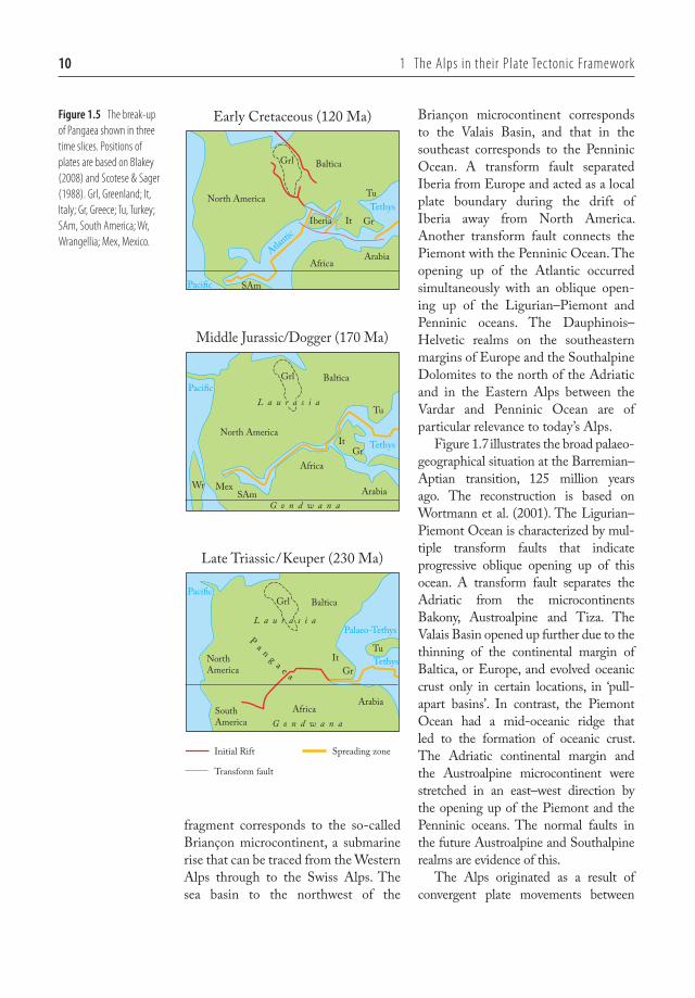
The break-up of Pangaea is illustrated in three snapshots in time in Fig. 1.5. A level of uncertainty is associated with all of these plate reconstructions, which is why these palaeogeographic maps also vary greatly from one author to the next. Figure 1.5 was simplified and redrawn from illustrations by Blakey (2008). In the Early Triassic (Keuper), 230 million years ago, Pangaea broke up along a rift that opened up between Gondwana and Laurasia. The rift originated in the Tethys, and extended along an arm of the Tethys between the continental masses of Arabia and Greece–Italy. The Palaeo-Tethys was then closed by subduction, such that the Turkish landmass was welded to Laurasia (Baltica) in the Middle Jurassic (Dogger), 170 million years ago. The eastern part of the rift shifted to the north and now separated the landmass Greece–Italy from Laurasia. This small ocean basin is referred to as the Ligurian or Piemont Ocean in Alpine geology. The rift expanded to the west and separated Africa–South America from North America. This rift was the
precursor to the Atlantic and extended as far as Mexico. In the Early Cretaceous, 120 million years ago, North America and Africa drifted further apart and the Central Atlantic was born. In the north, Iberia separated from North America. The movement of Iberia was due to a spreading ridge in the west (mid-oceanic ridge of the Atlantic as it was opening up) and a transform fault to the north and to the south of Iberia. In the north, further spreading systems extended either side of Greenland. These were the forerunners for the opening up of the North Atlantic.
Figure 1.6 shows a simplified plate reconstruction for the Jurassic–Cretaceous transition (about 145 mil-lion years ago), adapted from Wortmann et al. (2001). Opinions diverge on the exact geometries of the individual basins, but the solution given in Fig. 1.6 is a combination of their essential char-acteristics. This shows a continental fragment extending from Iberia in a northeasterly direction and composed of Corsica–Sardinia–Briançon, which became separated from Iberia. The Corsica–Sardinia–Briançon continental
[km]
0
–50
SE
Lithospheric mantle
BalticaPost-Variscan sedimentsPalaeozoic sediments with ophiolites
Seismic MohoPetrologic Moho
Africa / Gondwana
Crystalline basement
Saxothuringian MoldanubianBarrandian
Gießen nappeTaunus
Molasse BasinSpessart Central Bohemian
shear zone
0002087327.INDD 9 3/11/2014 10:56:26 AM
10 1 The Alps in their plate Tectonic framework
fragment corresponds to the so-called Briançon microcontinent, a submarine rise that can be traced from the Western Alps through to the Swiss Alps. The sea basin to the northwest of the
Briançon microcontinent corresponds to the Valais Basin, and that in the southeast corresponds to the Penninic Ocean. A transform fault separated Iberia from Europe and acted as a local plate boundary during the drift of Iberia away from North America. Another transform fault connects the Piemont with the Penninic Ocean. The opening up of the Atlantic occurred simultaneously with an oblique open-ing up of the Ligurian–Piemont and Penninic oceans. The Dauphinois–Helvetic realms on the southeastern margins of Europe and the Southalpine Dolomites to the north of the Adriatic and in the Eastern Alps between the Vardar and Penninic Ocean are of particular relevance to today’s Alps.
Figure 1.7 illustrates the broad palaeo-geographical situation at the Barremian–Aptian transition, 125 million years ago. The reconstruction is based on Wortmann et al. (2001). The Ligurian–Piemont Ocean is characterized by mul-tiple transform faults that indicate progressive oblique opening up of this ocean. A transform fault separates the Adriatic from the microcontinents Bakony, Austroalpine and Tiza. The Valais Basin opened up further due to the thinning of the continental margin of Baltica, or Europe, and evolved oceanic crust only in certain locations, in ‘pull-apart basins’. In contrast, the Piemont Ocean had a mid-oceanic ridge that led to the formation of oceanic crust. The Adriatic continental margin and the Austroalpine microcontinent were stretched in an east–west direction by the opening up of the Piemont and the Penninic oceans. The normal faults in the future Austroalpine and Southalpine realms are evidence of this.
The Alps originated as a result of convergent plate movements between
Early Cretaceous (120 Ma)
Middle Jurassic/Dogger (170 Ma)
Late Triassic/Keuper (230 Ma)
BalticaGrl
North America
SAm
Africa
Tu
Arabia
It GrIberia
L a u r a s i a
BalticaGrl
North America
SAm
Africa
Arabia
Tethys
G o n d w a n a
MexWr
NorthAmerica
SouthAmerica
Africa
BalticaGrl
L a u r a s i a
G o n d w a n a
P a n g a e a
ItGr
Tu
Arabia
ItGr
Tu
Paci�c
Paci�c
Tethys
Atlantic
Paci�c
Palaeo-Tethys
Tethys
Spreading zoneInitial Rift
Transform fault
Figure 1.5 The break-up of pangaea shown in three time slices. positions of plates are based on Blakey (2008) and Scotese & Sager (1988). Grl, Greenland; It, Italy; Gr, Greece; Tu, Turkey; SAm, South America; Wr, Wrangellia; mex, mexico.
0002087327.INDD 10 3/11/2014 10:56:27 AM

Baltica/Europe and Africa–Arabia. During this process, the sea basins that lay between, the Piemont Ocean and the Valais Basin, were closed up by subduc-tion. This occurred in two separate stages.
The Piemont–Penninic ocean was closed by subduction proceeding in a westerly direction in the Cretaceous, the Valais Basin by a collision in the Cenozoic between the Briançon microcontinent
25°N
20°N
30°N
Cors.-Sardin.
Briançon
Alboran
Africa
Vo
Bakon
y
Drau
Vard
ar
Tiza
Southalpine
E u r o p e
Adr ia
I b e r i a
Dolomites
Dauphinois - H
elveti
c
VS
Aust roa
lpin
e
Li
Pi
Pe
LandEpicontinental sea
Passive margin Spreading ridgeTransform fault Modern coast lineOcean
Active margin
Figure 1.6 plate reconstruction for the Berriasian (ca. 145 million years ago), simplified after Wortmann et al. (2001). The Ligurian (Li)–piemont (pi) Ocean stretches between the microcontinents of Iberia and Adria. It is disrupted by a transform fault and continues as the penninic (pe) Ocean between the Briançon and Austroalpine continental fragments. Narrow basins, the Vocontian (Vo) and Valais (VS) straddle the southern margin of the European continent. cors-Sard, corsica–Sardinia continental fragment. Source: Wortmann et al. (2001). Reproduced with permission of John Wiley & Sons.
Dolomites
Drau
Briançon
Cors.-Sardin.
Alboran
Tiza
Bako
ny
Vard
ar
Afr ic a
I ber ia
Europe
Adr ia
VSVo
Ligur ian - P
iemon
t O
ce
an
Penn
inic
O
cean
Southalpine
Dauphinois - Helv
etic
25°N
20°N
30°N
Aust r
oalp
ine
LandEpicontinental sea
Shelf sea Spreading ridge
Transform fault Modern coast lineOceanActive margin
Figure 1.7 plate reconstruction for the Barremian (ca. 125 million years ago), simplified after Wortmann et al. (2001). The Ligurian–piemont Ocean is now wider and aligned with the penninic Ocean. Similarly, the Southalpine and Austroalpine domains are now aligned. cors-Sard, corsica–Sardinia continental fragment; Vo, Vocontian basin; VS, Valais basin. Source: Wortmann et al. (2001). Reproduced with permission of John Wiley & Sons.
1.2 Break-up of pangaea and Opening of the Alpine Tethys 11
0002087327.INDD 11 3/11/2014 10:56:28 AM

12 1 The Alps in their plate Tectonic framework
and the Adriatic continental margin, proceeding in a more north–south direc-tion and, later on, between the Briançon microcontinent and the European continental margin. The complex palaeo-geography illustrated in Fig. 1.7 leads us to surmise that the subduction and the collision process led to an even more complex geometry in the mountain chain that was being uplifted.
1.3 The Alpine system in Europe
The Alpine mountain ranges originated in the Cretaceous and in the Cenozoic. These ranges include, for example, the ‘young’ European mountain ranges (Betic Cordillera, Pyrenees, Alps, Apennines, Carpathians, Dinarides). Of note is that these mountain ranges are winding and arc-shaped. Figure 1.8 summarizes the continuing present-day motions (based on Kahle et al. 1995), which provide an insight into the plate tectonic processes during the formation of these mountain ranges. Africa is moving to the north by
four millimetres and more each year. Movement in the west is slightly slower, that is, Africa is rotating anti-clockwise very slightly. Arabia is moving much faster, at 25 millimetres per year, in a northern direction. The jump in speed is taking place in a strike-slip fault that originates in the spreading ridge in the Red Sea and extends northwards through the Gulf of Aqaba, via the Dead Sea and the Sea of Galilee. The Turkish block is moving in a westerly direction by 25 millimetres per year. The plate bound-ary in the north of this block is to be found in the North Anatolian fault line, a seismically active dextral strike-slip fault. This drift to the west changes its direc-tion to south-southwest in the Aegean. Its speed increases, as the Aegean is expanding in the same direction. The plate movements are revealed to be quite complicated, even just between Africa, Arabia and the Turkish block. Further north, this becomes even more compli-cated to understand.
In the East Carpathians, there is currently an active subduction zone that
�rust fault/Subduction
Normal fault/Extension
Strike-slip fault
1000km
4mm/a
Miocene
6mm/a 35mm/a
25mm/a
25mm/a
Africa
Arabia
Europe
Carpathians
Pontides
Betic Cordillera
Tell-Atlas
Balkans
Rif
Dinarides
Hellenides
Eastern Alps
Wes
tern A
lps
Apennine
Figure 1.8 The tectonic plates in the present-day Alpine system. Open arrows with velocities (mm/a) show the direction of plate motions, simple arrows indicate directions of thrusting within the Alpine orogens. Double arrows denote areas of extension and opening of ocean basins. Source: Kahle et al. (1995). Reproduced with permission of Elsevier.
0002087327.INDD 12 3/11/2014 10:56:29 AM

1.3 The Alpine System in Europe 13
is plunging towards the west. The Eurasian plate is sinking and simulta-neously exhibiting slab retreat or roll back, that is, the plate boundary is mov-ing towards the east in this subduction zone. As a result of this, the Pannonian Basin on the plate above is being stretched in an east-west direction. The Tiza block at the base of the Pannonian Basin is being squeezed out laterally towards the east by the pincer move-ment between Europe and Africa (or Apulia). However, at the same time, the Apennines and the Dinarides are also moving towards each other. Stretching and new formation of oceanic crust has been detected in the Tyrrhenian Sea in the hinterland of the active Apennines (Facenna et al. 2002). This process started about five million years ago. A little earlier, in the Miocene, the
Ligurian Basin opened up under similar circumstances. At that point, the Corsica–Sardinia microcontinent sepa-rated from Europe and, during the sub-sequent rotation away from Europe, new oceanic crust developed in the Ligurian Sea. Therefore, movements of the smallest blocks between the two colliding continental plates also occurred in this case.
Even today, active horizontal motion can be measured in the Alps (Tesauro et al. 2005). The southern margin of the body of the Alps is moving slowly towards the north-northwest, at about 1.2 millimetres per year, and the north-ern margin is moving at only about 0.7 millimetres per year, but in the same direction. This indicates that the Alps are contracting by about 0.5 millimetres per year in a NNW–SSE direction.
Vienna
Milan
Munich
Nice
TriesteVenice
▴ Figure 1.9 Digital elevation model of the Alps and neighbouring areas. Within the Alps, major valleys running parallel and across the orogen are clearly discernable. Large lowland areas lacking relief stretch across the foreland of the Alps. They correspond to the Rhine Graben in the north, the Bresse–Rhone Graben in the west, the po Basin in the south and the pannonian Basin in the east. Source: US Geological Survey.
0002087327.INDD 13 3/11/2014 10:56:30 AM

14 1 The Alps in their plate Tectonic framework
The complicated present-day pattern of movement gives an impression of how the movements that occurred dur-ing the formation of the Alps must be envisaged. The sizes of the ocean basins and continents or microcontinents that were involved were modest in compari-son with the dimensions in the classic subduction orogens of the Andes or the North American Cordillera, or in the collision mountain chains of the Himalayas or Appalachians. However, the convergent movements were quali-tatively comparable and made the Alps into a mountain chain with such a highly heterogeneous structure.
1.4 structure of the Alps
The mountainous body of the Alps extends in a wide arc from Nice to Vienna. The Po Basin lies within the arc. It is morphologically distinct due to its low altitude and minimal relief, as is made clear in the digital elevation model in Fig. 1.9. Long, narrow basins with no relief are visible outside the Alpine arc: the Rhone–Bresse Graben in the extreme southwest, the Rhine Graben in the north. In the far east of the region, the Alps disappear under the Vienna Basin.
Along this mountain chain, the Alps are subdivided into the Western Alps, Central Alps and Eastern Alps. The Eastern Alps run more or less east–west and their western boundary is located on an approximate line through St Margrethen–Chur–Sondrio. In the Central Alps, the course of the moun-tain chain changes from east–west to almost north–south. The Western Alps run from north to south, but form a tight arc round the western end of the Po Basin. The boundary between the Central and Western Alps is diffuse.
Some authors therefore only subdivide the Alps into the Western Alps and the Eastern Alps. While the three-part division is preferred here, this is simply due to the internal structures, which are hereby easier to classify in a compre-hensible manner.
Across this mountain chain, the Alps are subdivided into tectonic units that belong to specific palaeogeograph-ical domains. The palaeogeographical affiliation is defined by the Mesozoic sedimentary environment in these units. Based on this structure, we can distin-guish a belt of sedimentary rocks that belong to the European continental margin and are exposed in the extreme external regions of the Alps, that is, extreme west and north. These rock for-mations are referred to as ‘Dauphinois’ and ‘Helvetic’. A second belt of sedi-mentary rocks, summarized using the term ‘Penninic’, is located in a more central position, that is, it lies further to the east or south. The associated Mesozoic sediments were deposited in marine basins between the European and Adriatic continental margins. A third belt of sedimentary rocks is to be found mainly in the most internal loca-tion, towards the Po Basin. These units are referred to as ‘Austroalpine’ and ‘Southalpine’ and are allocated to the Adriatic continental margin. In general, the Penninic units lie on top of the Helvetic and the Austroalpine unit on top of the Penninic. All these units are actual nappe complexes that were transported hundreds of kilometres from their substratum in the form of relatively thin sheets of rock. Figure 1.10 shows the distribution of these nappe complexes throughout the Alps.
The Austroalpine nappe complex makes up almost the entire Eastern Alps. It is only at the outer margins in
Western Alps Central Alps Eastern Alps
0002087327.INDD 14 3/11/2014 10:56:30 AM

1.4 Structure of the Alps 15
the north and east that Penninic and Helvetic nappes can still be recognized in the footwall of the Austroalpine nap-pes. In the centre of the Eastern Alps, in the Tauern Window, the Austroalpine nappe complex is eroded, such that a spectacular view of the Penninic and Helvetic nappes lying below is revealed. A smaller, but otherwise equivalent, window is found slightly to the west, in the Lower Engadin. Further to the west, the Austroalpine nappe complex is almost fully eroded in the Central Alps. However, small erosional rem-nants, called klippen or outliers, remain as evidence for the original distribution. The largest of these klippen is to be found in the region of the Dent Blanche.
The Southalpine nappe complex and the adjacent Dolomites to the east are separated from the Austroalpine nappe complex by a major fault, the peri- Adriatic fault system. This continues eastwards into the Karawanks, where it separates the Dinarides from the Eastern Alps. The Southalpine nappe complex, the Dolomites and the Dinarides, were tectonically independent of the Austroalpine nappe complex. Only the affinity of the Mesozoic sediments to the Adriatic continental margin consti-tutes a common element.
The distribution of the Penninic nappe complex also reveals a large klip-pen in the region of the Central Alps, on the northern margin of the Alps. This is to be found in the French–Swiss Prealpine and in the Chablais region in France. Further smaller klippen are to be found in central Switzerland. These klippen also provide evidence that the Penninic nappes once covered large parts of the Alps.
The Jura Mountains are visible in Fig. 1.10 at the outermost margin of the Central Alps. At the end of nappe
formation in the Alps, this banana-shaped mountain range was com-pressed, folded and pushed to the northwest.
Younger, Cenozoic basins demarcate the edge of the Alps. In the north of the Alps, the Molasse Basin extends from Vienna, via Munich into the Swiss Central Plateau and peters out in a westerly direction. The Molasse Basin is a foreland basin that developed in the Oligocene–Miocene after Alpine nappe formation and was then filled with clas-tic deposits from the uplifting Alps. In the course of the most recent nappe movements, the Molasse Basin was mainly compressed at its southern mar-gin and even pushed to the northwest in the region of the Jura Mountains.
The rift system with the Rhine Graben and the Rhone–Bresse Graben is visible outside the Jura. The two rift basins are connected to each other by a transform fault system. Basement uplifts exposing crystalline rocks flank the rift basins on both sides: the Black Forest and Vosges, and the Massif Central and Massif de la Serre.
Finally, the Po Basin is visible in the south of the Alps, a foreland basin shared by the Alps and the Apennines. Clastic sediments up to ten kilometres thick were deposited in this basin in the Cenozoic. The basin fill was partially affected by the Alpine nappe move-ments, resulting in fold and thrust structures.
Figure 1.11 shows three schematic, simplified cross-sections through the Alps. These show commonalities and dif-ferences between the West, Central and Eastern Alps. All three cross- sections are based on insights gained from reflection seismic investigations conducted within the framework of three large national and international research programmes. The cross-section through the Western Alps is
▸ Figure 1.10 Simplified tectonic map of the Alps and their foreland. The Jura mountains, and Dauphinois–Helvetic nappe system are part of the European continental margin, the Austroalpine and Southalpine nappe systems represent the Adriatic margin. The penninic nappe system in between is derived from the Valais basin, the Briançon microcontinent and the penninic Ocean. Two tectonic windows (inliers) in the Engadin and Tauern prove that the penninic and Helvetic nappes have a subsurface continuation towards the east. On the other hand, klippen (outliers) of Austroalpine units at the transition between the central and Western Alps indicate the former extension of the Austroalpine nappes towards the west. A, B and c indicate the locations of the cross-sections shown in fig. 1.11.
European margin Piemont Ocean Adriatic margin
0002087327.INDD 15 3/11/2014 10:56:31 AM

16 1 The Alps in their plate Tectonic framework
based on the Franco-Italian project ECORS-CROP (Nicolas et al. 1990, Roure et al. 1996, Schmid & Kissling 2000), that through the Central Alps on
the Swiss National Research Project, NFP 20 (Pfiffner et al. 1997) and, finally, the cross-section of the Eastern Alps is based on the Germano-Austro-Italian
B
A
Southalpine nappe systemSi
In
En
Molasse Basin
Helvetic nappe system
Penninicnappe system
Penninicnappesystem
Jura Mountains
European Foreland
Provence Platform
Valence Basin
Bresse Graben
ValensoleBasin
Rhine Graben
BlackForest
Vosges
Esterel
Massif central
Dauphinoisnappe system
Torino
Marseille
Nice
Avignon
Valence
Lyon
Geneva
KonstanzBasel
Strasbourg
Genova
Milan
5°
5° 10°
10°
45°
46°
47°
48°
44°
0002087327.INDD 16 3/11/2014 10:56:32 AM
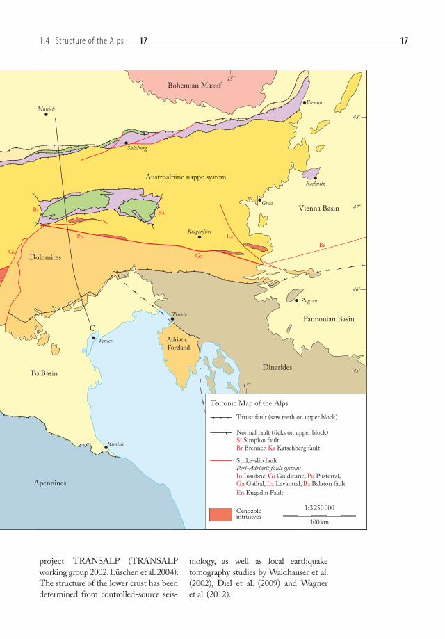
1.4 Structure of the Alps 17 17
project TRANSALP (TRANSALP working group 2002, Lüschen et al. 2004). The structure of the lower crust has been determined from controlled-source seis-
mology, as well as local earthquake tomography studies by Waldhauser et al. (2002), Diel et al. (2009) and Wagner et al. (2012).
�rust fault (saw teeth on upper block)
Tectonic Map of the Alps
Normal fault (ticks on upper block)Si Simplon faultBr Brenner, Ka Katschberg fault
Strike-slip faultPeri-Adriatic fault system:In Insubric, Gi Giudicarie, Pu Pustertal, Ga Gailtal, La Lavanttal, Ba Balaton faultEn Engadin Fault
Cenozoic intrusives
100km
1:3250000
C
Apennines
Dolomites
Dinarides
Austroalpine nappe system
Ga
LaBa
Pu
Br Ka
Gi
Po Basin
Pannonian Basin
Vienna Basin
Adriatic Foreland
Bohemian Massif
Munich
Salzburg
Vienna
Graz
Zagreb
Rechnitz
Klagenfurt
Venice
Rimini
Trieste
15°
15°
48°
47°
46°
45°
0002087327.INDD 17 3/11/2014 10:56:33 AM

18 1 The Alps in their plate Tectonic framework
100km
Molasse Basin
Molasse Basin
Aar
Tauern
Ivrea
Western Alps
Central Alps
Eastern Alps
Jura Mountains Chaînes subalpines Po Basin
Aarau
(Munich)
Luzern (Varese)
(Geneva) (Aosta) (Ivrea)
(Treviso)Northern Calcareous Alps Dolomites
Insubric Fault
[km]
0
–20
–40
–60
WNW ESE
0
–20
–40
–60
[km]
[km]
0
-20
-40
-60
0
-20
-40
-60
[km]
[km]
0
–20
–40
–60
0
–20
–40
–60
[km]
NNW SSE
NW SE
Moho
Moho
Moho
0002087327.INDD 18 3/11/2014 10:56:34 AM

1.4 Structure of the Alps 19
The cross-section through the Western Alps shows how the crust of the European continental margin plunges below the Alps in an east-southeast direction, beneath both the mantle and the crust of the Adriatic continental margin. The steep contact contains a strike-slip component (the eastern portion moved towards the north). Thrust faults in the European crust indicate substantial compression in an east–west direction, which at least doubled the thickness of the crust. Larger basement uplifts in the Chaînes subalpines and the Penninic nappe complex lead to the conclusion that iso-lated crystalline basement blocks were overthrust in a westerly direction on to the foreland over a distance of more than 100 kilometres. The Mesozoic sediments of the Jura Mountains were also affected by this and were actually thrust on to the Cenozoic sediments of the Bresse Graben. On the Adriatic side, the crustal blocks were thrust on top of each other in an easterly direc-tion. These structures are covered by the Po Basin fill and are known only from seismic investigations. Lower crust reached the surface of Earth in the Ivrea Zone, and mantle rocks almost did. This elevated location of the boundary
between crust and mantle is unique and is due to an inherited geometry from the time of the formation of the Piemont Ocean. Remnants of this ocean can be found in the thin band of ophiolites interlayered with detached pieces of upper crustal crystalline base-ment nappes.
The European crust also plunges below the Alps in a south-southeast direction in the cross-section of the Central Alps. The upper crust has been peeled off the lower crust and piled up into a nappe pile composed of crystal-line basement nappes. The lower crust runs underneath the compressed mar-gin of the Adriatic plate. Similar to the cross-section of the Western Alps, the Adriatic mantle and the lower crust are in a shallow position. They were pushed northward along a south-dipping thrust fault cutting across the entire litho-sphere, a style that is referred to as thick-skinned tectonics. A steep fault, the Insubric fault, separates the rocks of the Adriatic and European plates. The fault exhibits two movement compo-nents. The packages of upper crust from the European margin that had been peeled off moved southwards and up along a steeply dipping thrust fault and, in some instances simultaneously, the
▴ Figure 1.11 Three schematic cross-sections through the Western, central and Eastern Alps based on geological and geophysical data. The upper crust in these cross-sections is shortened considerably by thrusting and folding, whereas the lower crust and lithospheric mantle show a much simpler structure. Locations of the cross-sections are shown in fig 1.10.
Cenozoic
Mesozoic of Helvetic -Dauphinois nappe systemAllochthonous Mesozoicof Jura MountainsAutochthonous Mesozoicof European Foreland
Permo-Carboniferous
European upper crust
European lower crust
Lithospheric mantle
Lithospheric mantle
Jura Mts & Helvetic nappe system
Mesozoic sediments
Crystalline basement/European upper crust
Mesozoic oceanic crust
Penninic nappe system Austroalpine & Southalpine nappe systems
Cenozoic
Mesozoic of Austroalpine
Mesozoic of Southalpine
Adriatic upper crust
Adriatic lower crust
European continental margin Adriatic continental margin
motion away from observer
motion towards observer
Strike-slip along Insubric Fault:
0002087327.INDD 19 3/11/2014 10:56:35 AM

20 1 The Alps in their plate Tectonic framework
Adriatic block moved horizontally westwards in a dextral fashion. Klippen of Helvetic and Penninic nappes made of sedimentary rocks lie to the north of the Aar massif. These were sheared off their crystalline substratum and pushed over 100 kilometres in a northerly direction. During this process, they also ended up on top of the internal, south-ern portions of the Cenozoic fill of the Molasse Basin.
In the cross-section through the Eastern Alps, although the European crust also sinks below the Adriatic con-tinental margin in a southerly direction, the extent of shortening appears slightly lower. Similarly, the Adriatic litho-sphere plunges toward the European plate in a northerly direction. In both cases, the lower crust is thickened con-siderably at their interface. A promi-nent basement uplift of crystalline rocks is present and emerges in the Tauern Window. A steep fault on the south side of the Tauern Window, the Pustertal fault, separates the Eastern Alps from the Dolomites. In the Dolomites, multiple thrust faults are visible. They have a south-directed transport and extend deep down into the crystalline rocks of the crust. The continuation of these thrust faults deeper down and their merger with the large thrust fault at the base of the Tauern massif is speculation. The struc-ture of the lower crust, at least, is fairly certain based on the teleseismic investi-gations. There are Mesozoic sediments overlying the Tauern crystalline base-ment that are comparable to those in the Helvetic nappe complex in the Central Alps. In turn, Penninic nappes overlie these sediments and are them-selves overlain by Austroalpine nappes. A larger complex of Austroalpine nap-pes, called the Northern Calcareous Alps, lies to the north of the Tauern
Window on a cushion of Penninic nap-pes. The Northern Calcareous Alps were telescoped together into a nappe complex as early as the Cretaceous, when some of the thrusting occurred in a westerly direction.
References
Blakey, R., 2008, Regional Paleogeographic Views of Earth History, Northern Arizona University, http://jan.ucc.nau.edu/~rcb7/RCB.html
Diel, T., Husen, S., Kissling, E. & Deichmann, N., 2009, High-resolution 3-D P-wave model of the Alpine crust. Geophysical Journal International, 179, 1133–1147.
Elliott, D. & Johnson, M. R. W., 1980, Structural evolution in the northern part of the Moine thrust belt, NW Scotland. Edinburgh Geological Society Transactions, Earth Sciences, 71, 69–96.
Facenna, C., Speranza, F., D’Ajello Caracciolo, F., Mattei, M. & Oggiano, G., 2002, Extensional tectonics on Sardinia (Italy): insights into the arc-back-arc tran-sitional regime. Tectonophysics, 356/4, 213–232.
Kahle, H.-G., Müller, M. V., Geiger, A., Danuser, G., Mueller, St., Veis, G., Billiris, H. & Paradissis, D., 1995, The strain field in northwestern Greece and the Ionian Islands: results inferred from GPS meas-urements. Tectonophysics, 249, 41–52.
Lüschen, E., Lammerer, B., Gebrande, H., Millahn, K., Nicolich, R. & TRANSALP Working Group, 2004, Orogenic struc-ture of the Eastern Alps, Europe, from TRANSALP deep seismic reflection pro-filing. Tectonophysics, 388, 85–102.
Matte, Ph., 1991, Accretionary history and crustal evolution of the Variscan belt in Western Europe. Tectonophysics, 196, 309–337.
Nicolas, A., Polino, R., Hirn, A., Nicolich, R. & Ecors-Crop working group, 1990, Ecors-Crop traverse and deep structure of
0002087327.INDD 20 3/11/2014 10:56:35 AM
References 21
the western Alps: a synthesis. In: Roure, F., Heitzmann, P. & Polino, R. (eds), Deep Structure of the Alps, Mémoires de la Société Géologique de France, Paris, 156, 15–28.
Pfiffner, O. A., Lehner, P., Heitzmann, P., Mueller, S. & Steck, A. (eds), 1997, Deep Structure of the Swiss Alps: Results of NRP 20, Birkhäuser, 380 pp.
Roure, F., Bergerat, F., Damotte, B., Mugnier, J.-L. & Polino, R. (1996), The Ecors-Crop Alpine seismic traverse, Mémoires de la Société Géologique de France, 170, 113 pp.
Schmid, S. M. & Kissling, E., 2000, The arc of the Western Alps in the light of geo-physical data on deep crustal structure. Tectonics, 19/1, 62–85.
Scotese, C. R. & Sager, W. W., 1988, Mesozoic and Cenozoic plate reconstruc-tions. Tectonophysics, 155, 27–48.
Strachan, R. A., Smith, M., Harris, A. L., & Fettes, D. J., 2002, The Northern Highland and Grampian terranes. In: Trewin, N. H. (eds), The Geology of Scotland, Geological Society of London, 81–147.
Tesauro, M., Hollenstein, C., Egli, R., Geiger, A. & Kahle, H. G., 2005, Continuous GPS and broad-scale defor-mation across the Rhine Graben and the Alps. International Journal of Earth Sciences, 94, 525–537.
TRANSALP working group, 2002, First deep seismic reflection images of the Eastern Alps reveal giant crustal wedges. Geophysical Research Letters, 29/10, 10.1029/2002GL014911, 92-1-92-4.
Wagner, M., Kissling, E. & Husen, S., 2012, Combining controlled-source seismology and local earthquake tomography to derive a 3-D crustal model of the western Alpine region. Geophysical Journal Inter-national, 191, 789–802.
Waldhauser, F., Lippitsch, R., Kissling, E. & Ansorge, J., 2002, High-resolution teleseis-mic tomography of upper-mantle structure using an a priori three-dimensional crustal model. Geophysical Journal International, 150, 403–414.
Wortmann, U. G., Weissert, H., Funk, Hp. & Hauck, J., 2001, Alpine plate kinematics revisited: The Adria Problem. Tectonics 20/1, 134–147.
0002087327.INDD 21 3/11/2014 10:56:35 AM

0002087327.INDD 22 3/11/2014 10:56:35 AM