1. strait of hormuz - shodhganga
TRANSCRIPT

145
1. Strait of Hormuz
1.1. Introduction
According to the Rimland theory of “Spykman”1, any country which captures Rimland, will
control the whole World, and “in this theory, the Strait of Hormuz has been considered as
Rimland‟s centre.”2
Map 4.1.: Strait of Hormuz*
*Source: Pars times
Albuquerque; the Portuguese navigator (1453-1515), believed that any country which
dominates three straits; Bab-el Mandeb, Hormuz and Malaka, would dominate the whole
1 Nicholas John Spykman (1893 – 1943) was a Dutch-American geostrategist, known as the "Godfather of Containment”.
2 Elahi Homayoun, “The Persian Gulf and Its Problems”; 8th edition, Ghoomes, Tehran, 2005, p.61
146
world. “In this theory the Strait of Hormuz is the dominant key over the other two straits. He
occupied Hormuz Island in the mouth of the Strait of Hormuz to ease capturing India.”3
Admiral Mahan (1840-1914), who has been known as the „Father of Maritime Strategy‟,
regarding the important role of the Indian Ocean stated that “Any power which controls Indian
Ocean will predominate the World .This ocean is the key of Seven Oceans and in 21st century
the World‟s future will be determined in Indian Ocean.”4 The Strait of Hormuz is the
connecting point of the most of the Middle East countries to the Indian Ocean.
Regarding the critical role of strategic straits of the world, in 1804 Napoleon Bonaparte said:
“If we could be the master of world‟s straits for six hours, we will become the master of the
world.”5
As these theories are still acceptable by majority of the theorists, the importance of the Strait
of Hormuz seems undeniable.
The Strait of Hormuz has been well known since ancient times, when the first seafarers in
modern civilization departed the Babylonian Empire to the Arabian Sea to conduct trade with
tribes to the east and west.
After Second World War, some reasons, which have been mentioned below, caused the
region becoming the centre of conflicts and competition, the centrality of this region in the
global politics also increased the importance of the Strait of Hormuz as the sole waterway
between the Persian Gulf and open seas.
Following are some of these reasons:
1. Increasing the importance of the Persian Gulf‟s States; due to their oil; its quantity as well
as the world‟s economy‟s dependence on that,
2. “Vital role of the Persian Gulf in The Allies victory in the Second World War”6,
3. Military, Economic and Political weakness of European States, due to the Second World
War,
4. Emergence of two superpowers; USA and USSR in the international political scene as two
leaders of the rival pillars, and starting the Cold War era,
5. Expansion and success of the anti-colonial movements in colonial regions.
Persian Gulf was under the complete dominance of Britain for more than one century and for
most of the 20th century the strait was controlled by the Royal Navy of England. In 1968,
when Britain declared that it will withdraw from the East part of Suez Canal (including the
Persian Gulf) in 1971, regional and global motions to obtain and keep the dominance over the
Persian Gulf and the Strait of Hormuz increased rapidly, and power in the Persian Gulf shifted
3 Ibid
4 Mahajan V.D. “International Relations since 1900”, S. Chand and Company Ltd., New Delhi, 1989, p. 814
5 Till, Geoffrey, “Maritime Strategy and the Nuclear Age”, McMillan; London,1984, p.130
6 N.2

147
to the United States and its allies. At the time Iran was a pro-western country ruled by the
Shah.
Britain‟s withdrawal had two different impacts on region‟s political-military circumstances:
1. Some of the regional States which had recently become independent; Kuwait, Qatar,
Bahrain, Abu Dhabi, Dubai, Ajman, Sharjeh, Ras-al-Khaima, Om-al-Quain and Fujairah, were
anxious about their future security.
2. Iran, Iraq and Saudi Arabia as the powerful regional states, considered Britain‟s withdraw
as their more effective presence in the region. For Iran, the strait was (and still is) vital
passageway for oil exporting and moreover, dominating it would strength Iran‟s international
position. Therefore, Iran and Saudi Arabia‟s role in protecting the region‟s security gradually
increased.
Today, the Strait of Hormuz gets attention as one of the most volatile and politically edgy
stretches of water in the world. The narrow Strait of Hormuz is considered one of the most, if
not the most, strategic straits of water on the planet and world‟s most critical oil traffic
chokepoint. According to the U.S. Energy Information Administration report in July 2008,
more than 15 million barrels of crude oil onboard enormous ships, called „super tankers‟,
which each carry more than 2 million barrels of crude, pass through the strait, every day. This
represents 40% of the world's seaborne oil shipments, and 20% of all world shipments. It is
necessary to mention that the role of Strait of Hormuz is proportional and depends on the
safety and security of it, such as happened in 1980s when the oil export of Saudi Arabia from
Strait of Hormuz decreased from 100% in 1980 to 75% in 1990; due to Iran-Iraq and First Gulf
Wars, which threatened the security of this hub. As Strait of Hormuz connects Gulf countries
with Indian Ocean, it has become an operational centre in military strategies.

148
1.2. Geographical Specifications of the Strait
The Strait of Hormuz is a narrow waterway that forms the entrance to the Persian Gulf. It is a
channel linking the Persian Gulf (west) with the Gulf of Oman and the Arabian Sea
(southeast).
The northern shore is formed by the coastline of Iran. The southern shore is formed by the
Musandam Peninsula which belongs to Oman.
The strait is 55 to 95 kilometres wide and separates Iran (north) from the Arabian Peninsula
(south).
The Strait is deep and relatively free of maritime hazards. Its depth is greatest near the
Musandam Peninsula and tapers as one moves north toward the Iranian shore and is
therefore difficult for large ships to navigate.
Map 4.2.: The Unsafe Areas for Tankers in the Strait*
*Source: Strauss Centre for International Security and Law, the University of Texas
149
However, 50 nautical miles to the west of the strait, inside the Persian Gulf, the situation is
reversed and the deeper water lies within Iranian territorial waters. At its narrowest point it is
made up of Omani and Iranian territorial waters and is only 54 kilometers wide and is
consequently a relatively easy passageway to obstruct.
The Strait contains eight major islands, seven of which are controlled by Iran. Iran and the
United Arab Emirates disagree as to the ownership of the strategically located Abu Musa,
Greater Tunb, and Lesser Tunb islands. Nonetheless, Iran has maintained a military
presence on these islands since the 1970s. Additionally, Iran's navy has good access to
open sea from bases at Bandar Abbas, Bushehr, and Chah Bahar. The de facto Iranian
control of these islands certainly strengthens Iranian influence in the waters of the Strait.
From the strategic point of view, in the Middle East, Strait of Hormuz is the most important
connecting centre which connects Mediterranean Sea and Red Sea with Indian, Pacific and
Atlantic Oceans.
1.3. Law of the Sea on the Strait of Hormuz
Historically, a nation‟s territorial waters were said to extend for 3 miles from shore. After the
Second World War this was reviewed and the current distance accepted by most countries is
12 nautical miles. Under the 1982 United Nation‟s Law of Sea (LOS) Convention, a coastal
state may claim a territorial sea up to 12 nautical miles from the coastline. Each nautical mile
is equal to 1852 meters.
The waters inside this 12 mile limit are broadly considered to be an extension of the nation
that forms its coastline. In addition to their right to enforce any law within their territorial seas,
coastal states are also empowered to implement certain rights in an area beyond the
territorial sea, extending for 24 nautical miles from their shores, for the purpose of preventing
certain violations within the territorial sea. “This area, known as the „contiguous zone‟, may be
used by a coast guard or its naval equivalent to pursue and, if necessary, arrest and detain
suspected drug smugglers, illegal immigrants and customs or tax evaders violating the laws
of the coastal state within its territory or the territorial sea.”7 However, foreign ships can pass
through these waters as long as they don‟t linger unnecessarily or cause aggravation while
there. This is termed the right of „innocent passage‟.
While passing through straits, such as the Strait of Hormuz, that run through territorial waters,
ships in transit have more rights. In particular, warships can maintain an appropriate degree
of combat-readiness. Foreign warships are usually required to minimise their military profile in
order to reduce their potential threat to the coastal state.
7 The United Nations Convention on the Law of the Sea, www.un.org
150
Warships which do not comply with the laws and regulations of the coastal state concerning
passage through the territorial sea can be ordered to leave the territorial sea immediately.
In the Strait of Hormuz and the waters to the west of it, shipping lanes run close to and in
some areas through Iranian territorial waters. Under international maritime law the Iranians
are entitled to monitor this traffic but the traffic, including warships, is entitled to unimpeded
transit. As the US and Iran view each other with great mistrust, the potential for conflict is
high. Two things, as follows, complicate the matter further:
1. The USA has not ratified (formally agreed to abide by) the relevant legislation on
international maritime law; the United Nations Convention on the Law of the Sea (UNCLOS).
2. According to UNCLOS, if there are islands lying off a nation‟s coast then the 12 miles
extend from the outermost island. The area of sea around the Strait of Hormuz contains
several islands, for many of which the ownership is claimed by both Iran and the United Arab
Emirates; a pro-western country. Whoever owns the islands will own the territorial waters
around them, according to international maritime law as it is usually interpreted.
1.3.1. Traffic Separation Scheme
Ships moving through the Strait follow a Traffic Separation Scheme (TSS), which separates
inbound from outbound traffic to reduce the risk of collision.
Northern route has been determined for inbound traffic from Gulf of Oman to the Persian Gulf
and Southern route for outbound traffic from Persian Gulf. To traverse the Strait, ships pass
through the territorial waters of Iran and Oman under the transit passage provisions of the
United Nations Convention on the Law of the Sea. The strait consists of 2-mile wide channels
for inbound and outbound tanker traffics, as well as a 2-mile wide buffer zone.
Iran and Oman as the countries in northern and southern shores of the strait were controlling
this waterway in 1971. In 1973, as Oman was engaged with internal problem in Dhufar and
also because of lacking capable naval force; at that time, Iran achieved its goal of bringing the
strait under her complete control. Following the 1979 revolution in Iran, Iran‟s control of the
strait was initially dropped and Oman reinforced its military; especially naval power and
became sole controller of the strait.
By the outbreak of Iraq-Iran war in 1980, Iranian government realized the importance of this
vital waterway and again started to cooperate with Oman to control the Strait of Hormuz. After
1980-1988 war, Iranian armed units again were deployed at the strategic ports and islands.
At the present, the strait is being controlled by two regional and extra-regional powers. Iran as
a regional power controls Northern shore and USA and Britain by the help of Oman control
Southern shore of the strait.

151
Map 4.3.: TSS of the Strait of Hormuz*
((The blue arrows mark the location of the Traffic Separation Scheme))
*Source: Pars times
Huge oil tankers enter the Persian Gulf via northern part of the Strait of Hormuz; empty, and
after loading; when more depth is required (due to the increased weight), exit via southern
part.
1.4. Geostrategic Role of the Strait of Hormuz
Nowadays petroleum is the most important strategic commodity. The dependence on this
resource can be felt in the way society reacts to even minor shifts in oil markets. With
demand and consumption increasing, mankind‟s dependence on oil continues to grow. The
dependence is such that any minor interference in the production or distribution of oil has
profound economic and political consequences.
152
The world‟s oil dependence is facilitated by a complex delivery system, which; if disrupted,
could dramatically impair global economy. Oil supplies are particularly vulnerable at specific
geographic chokepoints en route to their final destinations. Chokepoints are waterways or
overland pipelines that transport large quantities of oil across narrow channels or vulnerable
regions.
The consequences of natural disaster, accident, or terrorist attacks at any of these points
would affect our way of life, from the financial markets and international trade to airline travel
and gas prices, for months. The Strait of Hormuz is by far the world‟s most important
chokepoint; over 17 million barrels of oil per day, “roughly one fourth of the world‟s total oil
consumption, which by 2020 this flow is expected to more than double”8, travel out of the
Persian Gulf through this strait.
As oil which is being exported through the Strait of Hormuz is projected to increase, ensuring
the flow of oil through this hostile region will continue to be a crucial issue in the years to
come. The abundance of oil and the world‟s dependence on imported oil from the Persian
Gulf region make the Strait of Hormuz one of the most critical places to watch.
Closure of the Strait of Hormuz would dramatically affect the world oil market, sending oil
prices well over $100 per barrel and restricting access to oil products to only the wealthiest
buyers.
According to the Energy Information Administration (EIA); June 2007, the regional states own
proven oil reserves of 728 billion barrels, representing 55 percent of the world's oil reserves,
oil production capacity of 25.4 million barrels per day (33 percent of the world total) and total
oil production of 23.6 million barrels per day in 2006.
Much of this oil is transported to Japan, Western Europe, and the United States who have a
vital interest in securing free passage through this strait. The potential for conflict over the
strait and the resources that traverse them are great. If wars were to break out in this region
oil would certainly be used as a weapon.
Moreover, European dependence on Gulf energy supplies is likely to grow substantially over
the “next 10 to 15 years” 9, particularly as North Sea oil and gas resources are depleted.
Many countries, including the United States and European countries, are trying to develop
alternative sources of oil and to conserve on energy consumption but thus far with modest
success. The enduring reality is that an adequate worldwide supply at fair-market prices will
remain reliant on unfettered access to Gulf oil.
8 OPEC Annual Report, 2007
9 Cutler J. Cleveland, Encyclopaedia of Earth, Last Updated: June 14th, 2007, www.eoearth.org
153
Consumers of Persian Gulf‟s oil in order to reduce their dependency on the region‟s oil have
chosen some strategies. “Some of them are as follows:” 10
1. Economizing energy consumption
2. Producing substituting energies; such as atomic energy
3. Increasing other oil basins‟ productions.
1.4.1. Impacts of the Closure of the Strait
The vital role of the Strait of Hormuz; especially in peace time, is undeniable. About 80% of
the region‟s oil is being exported through this strait and only 20% by using pipelines which
have not any economic justification. There is no doubt that by its obstruction under any
circumstances, the oil exporting will face very serious problems.
It should be noted that any action to stop the oil flow from the Persian Gulf region; such as
blocking the strait Hormuz, attacking the shipping lines and trying to blow up the pipelines or
the production and refinery facilities of the regional countries, will be considered as a serious
violation of the international laws and regulations for the concerned states. It would be in
practice like giving a declaration of war to them.
At the same time, it would be a serious challenge to the interests of the major oil importing
states; especially to the USA‟s interests, as Persian Gulf has been considered as an area of
vital interests. US governments feel obliged to stop any serious challenge to its vital interest,
by all means; including the military actions.
Any blockade of this strategic strait would restrict supplies to consumers in Asia, Europe and
US. Japan which gets more than 70% of its oil from the Persian Gulf and the USA would be
the most sensitive to a blockade.
Closures of the strait, even in short term will create political and economic consequences, of
which some of them are as follows:
1. The region‟s oil supply to the international market will be diminished,
2. Political and military presence of regional and global powers to reopen the strait will be
certain. By the failure of political efforts, the disputes will be changed to war and as a result,
the war will spread to the Indian Ocean and the littoral countries involvement ultimately will
increase the possibility of another world war,
3. As the Gulf countries depend on oil and its income and they have to import food and other
commodities, mostly via the Strait of Hormuz, the closure of the strait will cause decreasing
their incomes, and economic pressure on the people. These circumstances most probably will
cause social and political riots or even regime change in some of the states,
10
Hafeznia Mohammad Reza, “Persian Gulf and Strategic Role of Strait of Hormuz”, 4th edition, Samt, Tehran, 2005, pp, 361-363

154
4. Closure of the strait will also affect Western World in some ways such as; decreasing the
imported oil from the Persian Gulf region and decreasing the exported industrial products to
the region‟s huge markets which will subsequently decrease their national revenue.
1.4.2. Events Which Threaten the Strait’s Oil Transit
Obstruction of the strait seems very difficult, but not impossible. Amongst the regional states,
Iran will suffer more than others by closure of the strait. Saudi Arabia, Iraq, UAE and Oman
have substantial possibility for their oil exporting or commercial activities and Bahrain, Kuwait
and Qatar could use the territory of Saudi Arabia or UAE.
The Strait of Hormuz has been a matter of serious concern for the world for some time due to
the mounting tension and bellicose rhetoric between the US-Israel and Iran.
A serious threat to the Strait of Hormuz involves the ongoing dispute between the UAE and
Iran over three islands – Abu Musa, Greater Tunb and Lesser Tunb Islands – all located near
the Strait of Hormuz. Abu Musa Island is of particular interest because it is thought to contain
large deposits of oil. By 1992, Iran managed to informally secure the islands even though no
official agreement had been made with the UAE.
“The Iranian forces have done several manoeuvres aimed at closing the Strait of Hormuz at
the time of crisis and the Western forces in the region (in cooperation with the some of the
littoral countries or independently) have conducted several manoeuvres aimed at deterring
such plans.”11
Any attempt by Iran to close the Strait of Hormuz would involve tragic costs, but most of them
would be paid by Iran. As long as the United States and its allies in the region remain alert to
the threat and maintain adequate precautions, there is little reason to fear catastrophic
consequences. The first thing to bear in mind about closing the Strait is how much damage it
would do to Iran and its interests even to try. A threat against the oil traffic is a threat against
every oil user which would gain Iran all but universal enmity. In such a situation Iran's
enemies, and particularly the United States, would enjoy largely a free hand to act as they
see fit to break the blockade, and do what injury they chose to Iran in the process. Iran could
find itself entirely stripped of air and naval defences in the wake of US strikes. The United
States would probably find it necessary to seize many of the Iranian and Iranian-occupied
islands in the Persian Gulf, and would scarcely be in any hurry to return them. The military
bases and commercial facilities around Bandar Abbas would no doubt be extensively
damaged and perhaps even occupied. Moreover, the one state whose oil traffic would most
assuredly be seriously affected is Iran. American naval forces effectively control the seas
throughout the region and could block all ships carrying oil or oil products to or from Iran. Not
only would this cut off most of the revenues of the Iranian government and most of the
11
Aghai Diba Bahman, “Closing the Strait of Hormuz”, Persian Journal, November 10th , 2006, www.iranian.ws
155
nation's foreign exchange, but Iran actually depends on imports for many critical petroleum
products, due to its mismanagement of its own resources. Even the limited flow of oil through
pipelines would not necessarily be safe from US precision-weapons attacks.
“The closure of the Strait of Hormuz will have grave consequences for Iran”12, Riad Kahwaji,
founder and director of Institute for Near East & Gulf Military Analysis (INEGMA) told Al
Arabia News Agency in March 2009. "Iran will be bringing a disaster upon itself," he said.
"This could place Iran in a military confrontation with the entire world since all countries have
an interest in the Gulf region.” He added."
Kahwaji stated that the US could possibly engage in a war against Iran and would destroy
anything that blocks the marine traffic in this region. "The US could occupy the Iranian islands
that might be in the way and could eventually occupy the entire Strait of Hormuz." He added.
1.4.2.1. Possible Events
There are some events which could threaten the strait‟s transit and even cause the closure of
the strait:
1. Closure by Sinking Vessels
This situation due to its depth is impossible or at least very difficult; because the depth of the
strait is between 70-100 meters while any sinking ship will cover only 30 meters.
2. Closure by Mining
Although this is possible, but mine clearance system could make the straits secure very
rapidly. It is highly likely that surveillance would discover the mining before it had gone far.
Surveillance would reveal the locations of fields, greatly improving the effectiveness of mine
clearance.
It is not necessary to clear the entire width to permit resumption of traffic – a comparatively
narrow channel is all that is needed. It is most likely that the US Navy, assisted by Arab state
forces in the Gulf, could accomplish this in a few days. Merchant mariners and ship-owners
have always been ready to sail in harm's way as long as there was adequate compensation
for doing so.
3. Closure by Making Ships’ Transiting Insecure
By the use of missiles, bombardment, guerrilla operations or other threats, the strait could be
insecure, but on the other hand the operation‟s headquarters (islands or the coastal ports or
cities which are used as headquarters) also could be targeted or destroyed by enemy. Tanker
War during the Iraq-Iran War (1980-1988) is a manifest example of this bilateral vulnerability.
The anti-ship missile problem must be seen in an end-to-end perspective. The weak points in
such systems have always been in their methods for finding targets in the first place and
guiding the missile to a hit. Destroying or neutralizing these capabilities will quickly make anti-
ship missiles ineffective, even if it proves difficult to destroy the missiles themselves (as it very 12
Al-Arabia.net, an Arabic-Language News Network, March 6th, 2009

156
well could). The only feasible way to detect and locate targets is with radars. Since these
must announce the position they can fairly quickly be located and destroyed, even if they are
mobile and move frequently. Jamming could reduce the radars‟ effectiveness. Even without
attacks and jamming, the environment in the region of the Strait of Hormuz is generally
unfavourable for radar due to massive clutter as well as frequently difficult propagation
conditions, resulting in many missed detections and false tracks. A missile with a radar
seeker will also be affected by clutter, and this will serve to make relatively simple
countermeasures more effective in diverting the missile from its intended target. The
propagation environment in this area also is poor for infrared missile seekers, again
increasing the effectiveness of countermeasures. US and allied warships armed with anti-air
missiles would provide an added layer of protection by shooting down many incoming anti-
ship missiles.
4. Submarines
Due to its suitable depth, submarines also could make it insecure, though this will become a
maritime war.
Although, the strait has never actually been shut down yet, the constant political, religious,
ethnic and territorial disputes between the Persian Gulf countries have made the world
anxious in anticipation of obstruction.
1.5. Significant Events in the Strait Since 1980
1.5.1. Iran Threatened to Close the Strait in 1984
In 1984, Iran threatened to close the Strait of Hormuz after repeated attacks by Iraq disrupted
Iranian shipping. However, in order to continue exporting oil and maintain its economy‟s
stability, Iran needed to keep the strait open and ultimately backed down from this threat.
1.5.2. Praying Mantis
On April 18th, 1988, the US Navy waged a one-day battle against Iranian forces in and
around the strait. The battle, dubbed Operation Praying Mantis by the US side, was launched
in retaliation for the April 14th, 1988, mining of the “USS Samuel B. Roberts”13. The US forces
sank two Iranian warships and as many as six armed speedboats in the engagement.
1.5.3. The Downing of Iran Air Airbus 655
On July 3rd, 1988, 290 people were killed when an Iran Air Airbus A300 passenger jet was
shot down over the strait by the United States Navy guided missile cruiser USS Vincennes.
There is still lingering controversy about the event, considered among the most controversial
tragedies in aviation history.
13
This United States’ Navy’s ship was severely damaged by an Iranian mine in 1988.
157
1.5.4. Iran Threatened to Close the Strait in 1997
In 1997, Iran once again threatened to close the strait if the United States attempted to
interfere in its relation with other Gulf countries.
1.5.5. Collision between USS Newport News and Japanese Tanker Mogamigawa
On January 10th, 2007, the nuclear submarine USS Newport News, traveling submerged,
struck Mogamigawa; a 300,000-ton Japanese-flagged very large crude tanker, south of the
strait.
1.5.6. US- Iranian Naval Dispute in 2008
A series of naval stand-offs between Iranian speedboats and US warships in the Strait of
Hormuz occurred in December 2007 and January 2008. US officials accused Iran of
harassing and provoking their naval vessels; Iranian officials denied these allegations. On
January 14th, 2008, US naval officials appeared to contradict the Pentagon version of the
January 16th event, in which US officials said US vessels were near to firing on approaching
Iranian boats. The Navy's regional commander, Vice Admiral Kevin Cosgriff, said “the
Iranians had neither anti-ship missiles nor torpedoes, and l wouldn't characterize the posture
of the US 5th Fleet as afraid of these small boats."14
1.5.7. Iran Threatened to Close the Strait in 2008
“Naturally every country under attack by an enemy uses all its capacity and opportunities to
confront the enemy. Given the main route for energy to exit from the region, one of Iran‟s
steps will definitely be to exercise control on the Persian Gulf and the Strait of Hormuz.
Should a confrontation erupt between us and the enemy, the scope will definitely reach the oil
issue. Oil prices will dramatically increase. This is one of the factors deterring the enemy from
taking military action against Iran,”15 the commander of Iran‟s Revolutionary Guard Corps
(RGC), Major General Mohammad Ali Jafari, said in his interview with the Iran‟s local Jam-e
Jam newspaper in June 1st, 2008.
“In response to these threats, Vice Admiral Kevin J. Cosgriff; commander of the US 5th Fleet
stationed in Bahrain across the Persian Gulf from Iran, with a carrier strike force led by the
aircraft carrier USS Abraham Lincoln, warned that such an action by Iran would be
considered an act of war and that the US would not allow Iran to effectively hold hostage
nearly a third of the world‟s oil supply.”16 So with Iranian threats and counter-threats by the
US Navy, the Strait of Hormuz is again at the forefront of a possible military confrontation
between the parties.
14
Isenberg David, "A game of chicken in the Persian Gulf", Asia Times, January 10th , 2008 15
Iran’s Jam-e Jam newspaper, June 1st , 2008 16
Ertan Fikret, “Strait of Hormuz: The place to watch”, Turkish Today’s Zaman Magazine, July 6th , 2008
158
Chief of Staff of Iran's Armed Forces said on July 5th, 2008, that Iran's strategy is to keep the
Strait of Hormuz in southern Iran open, the official IRNA news agency reported. “But if the
country's interests are jeopardized in the region, we will not let any ship pass through the
Strait of Hormuz” 17, Major General Hasan Firouzabadi was quoted as saying. The army chief
underlined the role of the strait, saying that the Hormuz Strait is a strategic canal with vital
importance to Tehran.
1.5.8. Collision between USS Hartford and USS New Orleans in 2009
CNN News Agency reported in March 21st, 2009, that the USS Hartford collided with the USS
New Orleans in the strait, in March 20th 2009. There was no damage to the sub's nuclear
propulsion system and no disruption to shipping in the strategic Strait of Hormuz. The
collision mildly injured 15 sailors aboard the Hartford and ruptured a fuel tank aboard the New
Orleans, spilling 25,000 gallons of marine diesel fuel.
1.6. Substitute Routes for the Strait 1.6.1. Pipelines
Constructing oil pipeline networks is one of the available methods which could diminish the
involved regional and extra-regional countries‟ dependency on the Strait of Hormuz. Although
for the purpose of accessing to the markets, some oil pipelines have been constructed from
the region to the eastern shore of Mediterranean Sea, but economic concerns, especially
using tankers and super tankers to transit oil, are the reasons which exporters and importers
still prefer to use marine transporting.
1.6.1.1. Existing Pipelines
In 1980s due to Iran-Iraq War; especially Tanker War in the Persian Gulf which caused
numerous problems for oil transiting by ships, Gulf States and the consumer countries had to
react very seriously. They coordinated by establishing pipeline networks from the Persian
Gulf to Mediterranean and Red sea to transit the region‟s oil. This, decreased dependence of
regional and industrial states on the Strait of Hormuz.
“Iraq, the commencer of the war, and responsible for spreading insecurity and crisis in the
region, was the first regional state which completely cut its dependence on the Strait of
Hormuz, by transiting oil via Turkey, Jordan and Saudi Arabia”.18 Oil flows through the Strait
of Hormuz account for roughly two-fifths of all world traded oil, and closure of the Strait of
Hormuz would require use of longer alternate routes (if available) at increased transportation
costs. The most viable alternative to the Strait of Hormuz for oil exports is the East-West
Pipeline (Petroline), which traverses Saudi Arabia. Oil from the Persian Gulf can travel
through this pipeline to the port of Yanbu for export via the Red Sea. “As of 2006, the East-
17
“Iran warns of closure of Hormuz Strait if threatened” , China View, July 5th , 2008 18
N.10, pp. 343-351
159
West Pipeline operated at only 50% capacity, leaving slack capacity of about 2.5 million
barrels per day.”19
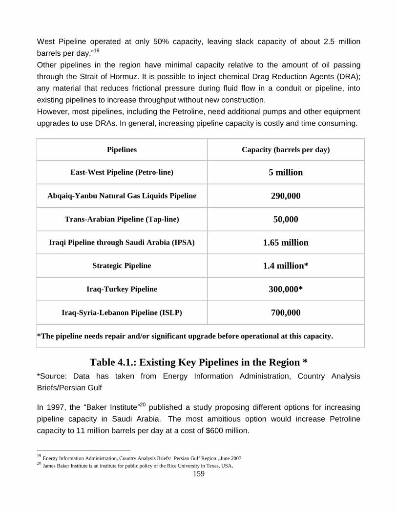
Other pipelines in the region have minimal capacity relative to the amount of oil passing
through the Strait of Hormuz. It is possible to inject chemical Drag Reduction Agents (DRA);
any material that reduces frictional pressure during fluid flow in a conduit or pipeline, into
existing pipelines to increase throughput without new construction.
However, most pipelines, including the Petroline, need additional pumps and other equipment
upgrades to use DRAs. In general, increasing pipeline capacity is costly and time consuming.
Pipelines Capacity (barrels per day)
East-West Pipeline (Petro-line) 5 million
Abqaiq-Yanbu Natural Gas Liquids Pipeline 290,000
Trans-Arabian Pipeline (Tap-line) 50,000
Iraqi Pipeline through Saudi Arabia (IPSA) 1.65 million
Strategic Pipeline 1.4 million*
Iraq-Turkey Pipeline 300,000*
Iraq-Syria-Lebanon Pipeline (ISLP) 700,000
*The pipeline needs repair and/or significant upgrade before operational at this capacity.
Table 4.1.: Existing Key Pipelines in the Region *
*Source: Data has taken from Energy Information Administration, Country Analysis
Briefs/Persian Gulf
In 1997, the “Baker Institute”20 published a study proposing different options for increasing
pipeline capacity in Saudi Arabia. The most ambitious option would increase Petroline
capacity to 11 million barrels per day at a cost of $600 million.
19
Energy Information Administration, Country Analysis Briefs/ Persian Gulf Region , June 2007 20
James Baker Institute is an institute for public policy of the Rice University in Texas, USA.
160
1.6.1.2. Planning Pipelines
The Gulf Cooperation Council (GCC) seems to have agreed to construct a new strategic
pipeline through Oman to a port on the Gulf of Oman. Gulf governments are planning oil
pipelines that would bypass the world's most vulnerable energy choke point, the Strait of
Hormuz.
If built, two pipelines; which have been described below, could ferry as much as 6.5 million
barrels of oil a day around the strait, an amount equal to nearly 40 percent of the daily exports
currently shipped through the narrow channel at the entrance of the Gulf.
1. The first, 224-mile pipeline would carry oil only from the United Arab Emirates, extending
from the country's Habshan oil field, across a mountain range, to the Emirate of Fujairah,
located outside the strait on the Gulf of Oman. But this pipeline would only carry UAE oil,
leaving producers such as Qatar, Kuwait, Saudi Arabia and Iraq still without an alternative
shipping route to Hormuz.
Abu Dhabi's International Petroleum Investment Co. is planning to build the line, which would
carry 1.5 million barrels per day of crude oil, about 55 percent of the Emirates' production. A
third of the crude would be used for a refinery planned in Fujairah.
2. The second line, dubbed the Trans-Gulf Strategic Pipeline, would bring as much as 5
million barrels a day from various Persian Gulf terminals to a newly built export terminal
outside the straits, perhaps in Oman.
“A forthcoming Gulf Research Centre study suggests six possible routes for the trans-Gulf
pipeline, which could bring oil from as far north as Iraq, passing through Kuwait, Saudi Arabia
and the UAE to the Omani capital of Muscat on the Arabian Sea”, 21 Mustafa Alani, a security
analyst for the Dubai-based Gulf Research Centre, said.
Other possible routes could be the pipeline terminating in Yemen or Fujairah. The idea of the
new pipelines among traders is so popular, "they think it's a dream," Alani said, "Crisis after
crisis is threatening stability. We need a permanent solution. Any threat, real or imaginary, will
increase the price a dollar or two. This project will give a new boost to the stability of oil," he
added.
1.6.1.3. Advantages of the Oil Pipeline Networks
1. As the Strait of Hormuz might be closed in any conflict, using multi-routes, pipeline plus
marine transporting, to and from the Persian Gulf will reduce the possibility of harming
commercial activities. In any situation of insecurity, if one of the routes is being threatened,
another one will be used.
21
China Daily News, March 21st, .2007

161
2. Some of the oil pipelines will reduce the distance to reach to the destinations. For example
to get the European and American oil markets, “Saudi Arabia‟s Guar-Yanbu oil pipeline,
compared with the Persian Gulf route, reduces the distance by about 3000 km.”22
1.6.1.4. Disadvantages of the Oil Pipeline Networks
1. Geographical conditions such as cold weather, mountains, marshes and water basins,
could make the construction of pipelines very difficult or even impossible.
2. In most areas the pipelines must pass through the cities, which will make the construction
very difficult.
3. Transport system via pipelines needs huge investments in construction, observation and
maintenance. In fact, using pipelines for transportation is “7.7 times more expensive than
marine transportation”.23
4. As from starting point to the destinations (consumption points), there are large water basins
like Red Sea and Mediterranean Sea, therefore to reach to final destinations, double-
transport system; pipelines and marine transportation, should be used. This will increase the
transportation costs.
5. Oil which is transported by pipelines to Red Sea shores must be carried by tankers and
passed through Suez Canal or Strait of Bab-el Mandeb to reach open seas:
5.1. To reach open seas via Suez Canal, oil must be transited by the tankers with the
capacity of less than 150,000 tones, because the draught of Suez Canal is not suitable for the
tankers above 150,000 tones. Therefore super-tankers which transit oil to America and
Europe ought to pass through Strait of Bab-el Mandeb and go round the south of Africa (Cape
of Good Hope). This increases the path and consequently the cost of transportation. But the
significant problem is that any instability in Yemen, Eritrea, Djibouti and Somalia will affect the
strait‟s traffic.
5.2. The other route that can be used to carry oil, which reaches to the Red Sea‟ shores
by pipelines, is Red Sea- Suez Canal- Mediterranean Sea- Strait of Gibraltar. To reach USA
and European markets this route is much more suitable than Strait of Hormuz, but not for
East Asian, Japan and Australia‟s markets (due to the distance). Any crisis in Israel or
Lebanon which are located in the east mouth of Mediterranean Sea seems the worst
possibility of disrupting oil transiting.
6. To reach Eastern Asia, Australia and Japan markets, the Strait of Hormuz is the shorter
way and also capable for super-tankers‟ transiting.
7. The possibility of sabotaging or exploding oil pipelines is a very serious threat which makes
the pipelines vulnerable. Explosion of the Hams (in Syria) - Tripoli (in Lebanon) oil pipeline, in
1981 and 1982, and subsequently destroying the Tripoli refinery, and explosion of the Kirkuk
22
N.10, p. 353 23
N.10, p. 366
162
(in Iraq) - Dortiul (in Turkey) oil pipeline, by Iraqi Kurd rebels in 1980, are examples which
confirm the vulnerability of oil pipelines in insecure areas.
8. Any conflicts in countries where the oil pipelines are passing through their territories could
cause the pipelines‟ closure; such as happened in Lebanon and obstructed Iraq and Saudi
Arabia‟s oil pipelines in 2006.
9. The most suitable route for Western consumers would be a pipeline through Saudi Arabia,
a nation friendly to the US. Any new pipelines, like the two already in existence, would
traverse Saudi Arabia and exit at the Red Sea where it could be loaded onto tankers. While
this would reduce insecurity, it is unpopular with many of the Gulf States. If a pipeline is built,
it will benefit Saudi Arabia and forcing other nations to pay transit fees for their oil transporting
via pipelines.
1.6.1. Substituting Canal
Constructing a substituting canal is another way to reduce the vital role of the Strait of
Hormuz. The idea of constructing a canal in Musandam Peninsula in Oman after the threat of
obstruction of the Strait of Hormuz in early 1980s took shape. But there are some serious
problems, such as follows:
1. According to the unsuitable geographical conditions of the area
2. Such canal could be controlled or even threatened or attacked by short-range and medium-
range missiles from Tunb, Geshm, Hengam and Abu Musa Islands.
Due to these problems, it has remained just as an idea.
According to The Times correspondent, David Robertson, in a September 9th, 2008 report,
Dubai is studying plans to build a US$ 200 billion (£114 billion) mega-canal that would allow
oil tankers to bypass the Strait of Hormuz. The Gulf Emirate is understood to be considering
the idea as a means of reducing Iran‟s influence on the flow of oil from the region. Engineers
are understood to have presented the plans for a 112-mile canal to the Dubai Government. It
would link the Gulf coast with the port of Fujairah on the Indian Ocean coast, crossing the
Hajar Mountains with a network of enormous locks. However, the proposed canal project
would be fraught with difficulty. Oil tankers weighing more than 300,000 tones would need a
route through the mountainous region between Dubai and its Indian Ocean coast. The
massive cost and complexity of the project is thought to have stalled a decision on the canal,
but it could be a popular initiative with other Gulf States.
“Many studies on this have been presented, but nothing is solid,”24 a senior official of the
Dubai Government, Mustafa Alani, of the Dubai-based think-tank Gulf Research Center told
Dow Jones in September 8th 2008. “Iran has clearly stipulated its intention to close the Strait
of Hormuz in case of a military conflict in the region”, he added.
24
”Canal to Bypass Strait of Hormuz”, Dow Jones, September 8th, 2008

163
2. Persian Gulf’s Islands
2.1. Introduction
There are about 130 explored islands in the region with different areas. According to their
location, they can be classified as follows:
1. Iranian Islands;
Iranian Islands are located in the northern part of the Persian Gulf. Most of the Iranian islands
are inhabited. Amongst them, seven islands by the reason of their strategic importance are
considered as the gulf‟s key which are; Hormuz, Larak, Qeshm, Hengam, Tunbs (Lesser and
Greater) and Abu Musa.
Map 4.4.: Location of the Iranian Islands near the Mouth of the
Strait of Hormuz*
*Source: Space Image Taken by NASA

164
2. Arabian Islands;
The Islands, which are mostly located in the centre or south part of the gulf, belong to the
Arab regional states. Most of them are uninhabited and stony or coral islands.
2.2. Iranian Strategic Islands
2.2.1. Hormuz Island
Albuquerque; Portuguese navigator in a letter to Portugal king wrote that:
“Your Majesty, if we consider the World as a ring, Hormuz (Hormuz Island) is its stone. To
occupy India and its sea routes, domination of following strategic points is necessary:
1. Hormuz Island in the entrance of Persian Gulf
2. Aden to keep Bab el-Mandab under control
3. Malaya Strait at the farthest end of Singapore Archipelago”25
Map 4.5.: Location of the Hormuz Island*
*Source: MSN. Encarta
The area of the island is about 41 square kilometres and is located in the entrance of Persian
Gulf and due to its strategic importance; the strait has been called Hormuz.
25
N10, p. 220
165
“In ancient Persian era, the Achaemenian had military bases on this island, and it was the
commercial centre of Indian, Chinese and other eastern commodities. Spice route also
passed through the island.”26
To possess India, in 1507, Portuguese occupied Hormuz Island, where was the world‟s trade
centre. By constructing military bases on the island, they assured their domination over
Persian Gulf. Exploration of oil in the region in 20th century, the island‟s geographical
conditions, its height, historical record and feasibility of approaching its southern offshore by
huge ships (the depth is almost 14 meters) are the reasons which have made the island
strategically very important, especially for Iran.
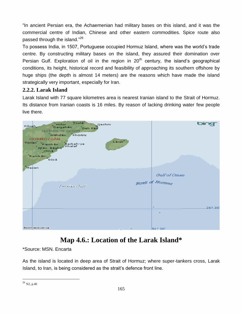
2.2.2. Larak Island
Larak Island with 77 square kilometres area is nearest Iranian island to the Strait of Hormuz.
Its distance from Iranian coasts is 16 miles. By reason of lacking drinking water few people
live there.
Map 4.6.: Location of the Larak Island*
*Source: MSN. Encarta
As the island is located in deep area of Strait of Hormuz; where super-tankers cross, Larak
Island, to Iran, is being considered as the strait‟s defence front line.
26
N2, p.40
166
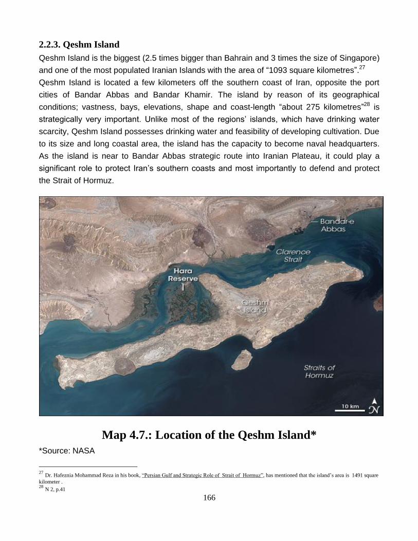
2.2.3. Qeshm Island
Qeshm Island is the biggest (2.5 times bigger than Bahrain and 3 times the size of Singapore)
and one of the most populated Iranian Islands with the area of “1093 square kilometres”.27
Qeshm Island is located a few kilometers off the southern coast of Iran, opposite the port
cities of Bandar Abbas and Bandar Khamir. The island by reason of its geographical
conditions; vastness, bays, elevations, shape and coast-length “about 275 kilometres”28 is
strategically very important. Unlike most of the regions‟ islands, which have drinking water
scarcity, Qeshm Island possesses drinking water and feasibility of developing cultivation. Due
to its size and long coastal area, the island has the capacity to become naval headquarters.
As the island is near to Bandar Abbas strategic route into Iranian Plateau, it could play a
significant role to protect Iran‟s southern coasts and most importantly to defend and protect
the Strait of Hormuz.
Map 4.7.: Location of the Qeshm Island*
*Source: NASA
27
Dr. Hafeznia Mohammad Reza in his book, “Persian Gulf and Strategic Role of Strait of Hormuz”, has mentioned that the island’s area is 1491 square
kilometer . 28
N 2, p.41
167
As Qeshm Island is a Free Trade Zone, it is very important to international trade. In the year
1994, upon approval by the Iranian Majlis, the provision of this free trade zone was identified
and as such, an area of 300 square kilometers on Qeshm Island received the designation of
free trade zone. To that end Qeshm Island was granted considerable leeway to set its own
policies, independent of the central government, which had often been seen as an
impediment to growth in many sectors of the economy. However, the Island retains the
advantages associated with its connection to the mainland, including the rights to explore and
develop oil and gas opportunities.
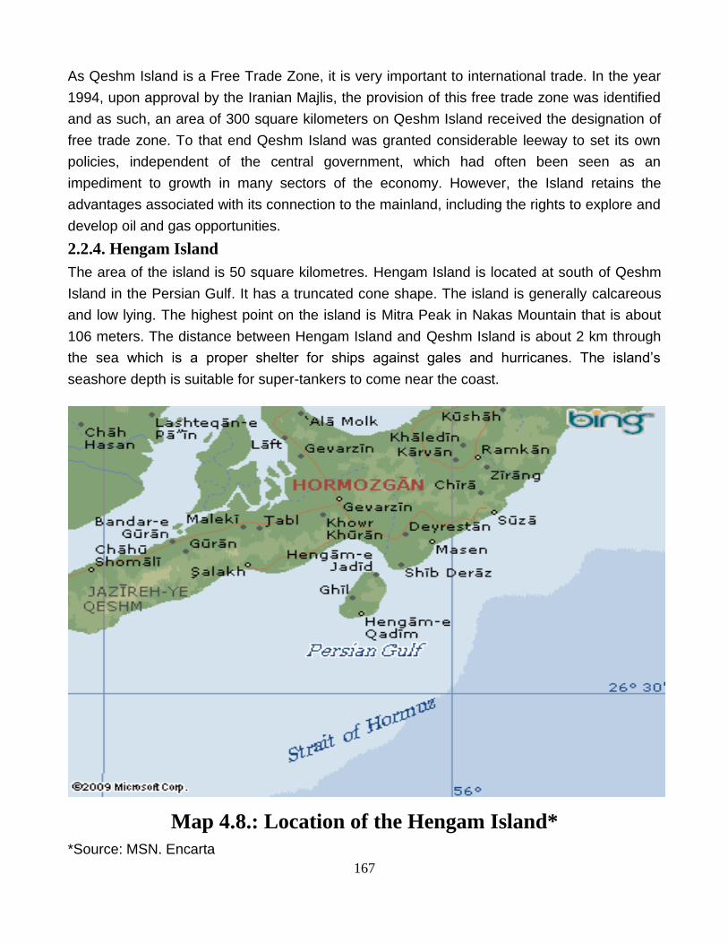
2.2.4. Hengam Island
The area of the island is 50 square kilometres. Hengam Island is located at south of Qeshm
Island in the Persian Gulf. It has a truncated cone shape. The island is generally calcareous
and low lying. The highest point on the island is Mitra Peak in Nakas Mountain that is about
106 meters. The distance between Hengam Island and Qeshm Island is about 2 km through
the sea which is a proper shelter for ships against gales and hurricanes. The island‟s
seashore depth is suitable for super-tankers to come near the coast.
Map 4.8.: Location of the Hengam Island*
*Source: MSN. Encarta
168
Due to its location in Persian Gulf, the island could be the centre of naval operations to
disturb traffic of Strait of Hormuz and also to prevent any warship from entering into Persian
Gulf.
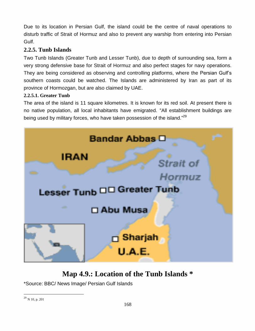
2.2.5. Tunb Islands
Two Tunb Islands (Greater Tunb and Lesser Tunb), due to depth of surrounding sea, form a
very strong defensive base for Strait of Hormuz and also perfect stages for navy operations.
They are being considered as observing and controlling platforms, where the Persian Gulf‟s
southern coasts could be watched. The Islands are administered by Iran as part of its
province of Hormozgan, but are also claimed by UAE.
2.2.5.1. Greater Tunb
The area of the island is 11 square kilometres. It is known for its red soil. At present there is
no native population, all local inhabitants have emigrated. “All establishment buildings are
being used by military forces, who have taken possession of the island.”29
Map 4.9.: Location of the Tunb Islands *
*Source: BBC/ News Image/ Persian Gulf Islands
29
N 10, p. 201
169
The island is located in the centre of navigation route, between inbound and outbound
corridors of Traffic Separation Scheme. Tankers which enter the Persian Gulf pass the
northern part of the island and tankers which exit Persian Gulf pass its southern part.
Because of its location, the island is a proper place for observation and control over maritime
traffic in the west side of Strait of Hormuz and east side of Persian Gulf.
Ample depth is needed for submarines‟ operations and manoeuvre. The depth of the most
parts of Persian Gulf is not sufficient for submarine operation, as “the deepest point of the gulf
is 93 meters.”30 Therefore the deep water around the island is a very suitable base for
submarines. This has made the island very important, strategically.
2.2.5.2. Lesser Tunb
It is a 2 square kilometres island. Because of lack of drinking water, the island is not habitable
and only a few military forces are present there.
In spite of its size and geographical conditions, there are two reasons which have made the
island strategically important:
1. The water around the island is deep enough for submarines‟ bases and movement of
super-tankers,
2. It is located between the inbound and outbound corridors of TSS (Traffic Separation
Scheme).
2.2.6. Abu Musa Island
Abu-Musa is a 14 square kilometres island which is located near the assumed western
military-strategic boundary of Strait of Hormuz between Iranian port, Lengeh, and UAE‟s port,
Dubai. Abu Musa lies in the Persian Gulf about halfway between Iran and the UAE.
For most of the recent years, it did not have more than a few dozen permanent residents.
However, both Iran and the UAE desire to control the island. Abu Musa is full of oil reserves,
which fuel the economies of both Iran and the UAE. In addition, the island is located in the
Strait of Hormuz, the mouth of the Persian Gulf. This strategic position could allow a country
to influence the Gulf's valuable shipping lane, or even to close off the Gulf all together.
Iran has controlled Abu Musa since 1971 when Britain ended its protectorate of the region.
Since then, Iran has rejected any arbitration, claiming the island as part of its territory. The
Island harbours a rich supply of untapped oil deposits.
Currently, oil is being extracted from a field close to the shores of Abu Musa. The dispute
over the island is unresolved and could ignite an international crisis at some point. When Iraq
made threatening moves toward Kuwait in October 1994, Iran increased its military presence
on Abu Musa.
30
N 2, p. 68

170
Neither the UAE nor GCC has contemplated an attack on Abu Musa because Iranian
fortification would make it too difficult to invade or to hold the island. Not only would an
invasion fail, but also Iran could respond by closing the Strait of Hormuz to all commerce,
including the oil trade.
Map 4.10.: Location of Abu Musa Island*
*Source: MSN. Encarta
Its highest height, Halva Kooh; with 110 meters height, is used as sailor‟s guide. Control of
Abu Musa also gives extra protection to the Iranian port; Bandar Abbas, which is strategically
important due to its oil industry and military base.

171
There are two groups of people who are living in the island:
1. Non-local Iranian, government‟s officers, military forces and constructors.
2. The island‟s roughly 500 inhabitants, “who are originally Iranian but Al-Sharjah‟s citizens.”31
They are supported by Al-Sharjah‟s government and are being paid a good amount as
monthly pensions. Drinking water and food are weekly brought to them by ships.
2.3. Arabian Strategic Islands
2.3.1. Musandam Peninsula
This island belongs to Oman. The Musandam Peninsula has an area of 1,800 square
kilometers and a population of 28,727 people. There is no land way between Oman‟s main
territory and this part of the country.
Map 4.11.: Location of the Musandam Peninsula*
*Source: MSN. Encarta
31
Dr. Hafeznia Mohammad Reza in his book; “Persian Gulf and Strategic Role of Strait of Hormuz” (p. 199), has estimated the island’s inhabitant; 618
persons.

172
It is separated from the rest of the country by the United Arab Emirates. Connectivity has
traditionally been a problem for the region, but this has greatly improved since August 2008
with the world's fastest passenger ferry launching service between Muscat, the capital of
Oman, and Musandam. The island‟s cape is the nearest point to Iran (with only 39 km
distance from Iranian island; Larak). Majority of its residences are originally Iranian.
Musandam Governorate has great strategic importance owing to its proximity to the Strait of
Hormuz. Its location gives Oman partial control, shared with Iran, of the strategic strait. The
most important part of Strait of Hormuz (its deepest part) is near to the island‟s coasts.
2.3.2. Bubiyan Island
This island is under Kuwait‟s sovereignty. It is the largest island in the Kuwaiti coastal island
chain with an area of 863 square kilometers. It is separated from the mainland in the
northeast by Khawr Abd Allah and from the mainland in the southwest by Khawr As-Sabiyah.
The latter channel trends around the northern end of Bubiyan Island, separating it from
Warbah Island.
Map 4.12.: Location of Bubiyan Island*
*Source: MSN. Encarta
173
About 5.4 kilometers northwest of Ras Al Barshah, the southernmost point, Bubiyan is linked
to the mainland by a concrete girder bridge over the Khawr as Sabiyah channel, 2.38
kilometers long, built in 1983, which is for military use only.
The island is situated in the north-western corner of the Persian Gulf. During the Persian Gulf
War of 1991 the bridge was destroyed, but has been rebuilt.
In November 1994, Iraq formally accepted the UN-demarcated border with Kuwait which had
been spelled out in Security Council Resolutions 687 (1991), 773 (1993), and 883 (1993)
which formally ended an earlier claim to Bubiyan Island.
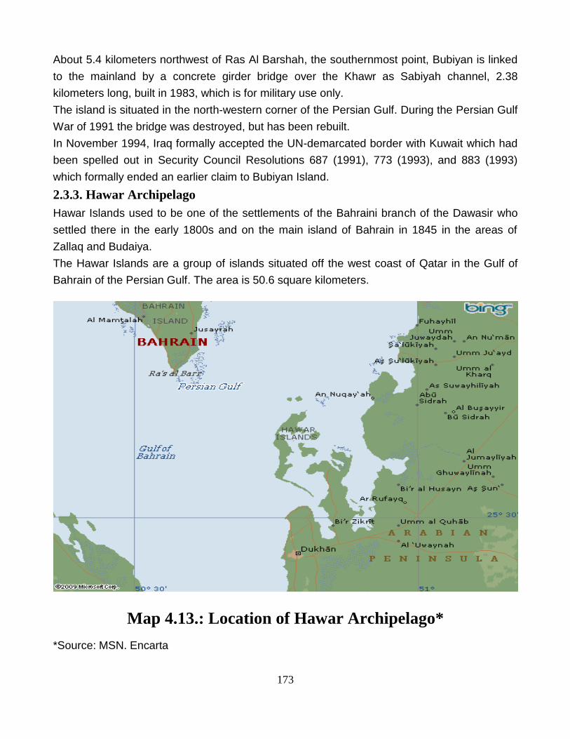
2.3.3. Hawar Archipelago
Hawar Islands used to be one of the settlements of the Bahraini branch of the Dawasir who
settled there in the early 1800s and on the main island of Bahrain in 1845 in the areas of
Zallaq and Budaiya.
The Hawar Islands are a group of islands situated off the west coast of Qatar in the Gulf of
Bahrain of the Persian Gulf. The area is 50.6 square kilometers.
Map 4.13.: Location of Hawar Archipelago*
*Source: MSN. Encarta

174
Despite their proximity to Qatar (one of these islands is only 1.4 km from the Qatari mainland
at the peninsula of Ras Abruq, while the closest island to the main island of Bahrain, lies at a
distance of 19.7 km to it), the islands belong to Bahrain but were the subject of a dispute
between Bahrain and Qatar. Resolution in 2001 of the dispute between Bahrain and Qatar
over the Hawar Islands improved their already warming relations. At the census of 2001, the
population numbered 3,875. A Hawari separatist movement exists in Europe but there is little
evidence of support for their movement in the Hawar Islands. In 2002, Bahrain applied to
have the Hawar islands recognized as a World Heritage Site, due to its unique environment
and habitat for endangered species. This site is home to many wildlife species and a very
interesting place for birdwatchers and divers.
2.4. Persian Gulf’s Disputed Islands
Territorial disputes amongst the states that straddle the Persian Gulf have been a perennial
feature of the region‟s geopolitical landscape ever since the retreat of British colonialism from
the Middle East.
There have been, and continue to be, significant territorial disputes between Persian Gulf
countries. Besides the Iraqi invasion of Kuwait in August 1990, and before that the Iran-Iraq
War from 1980 to 1988, another important dispute is between the UAE and Iran over
ownership of three islands; Abu Musa, Greater Tunb and Lesser Tunb Islands, all
strategically located in the Strait of Hormuz.
In January 1968, Britain announced that it would withdraw all of its forces from east of Suez
by the end of 1971. At that time the Sheikdom of Sharjah (later part of the UAE) controlled
Abu Musa. However, the Shah of Iran was very interested in the island. The Shah claimed
that Abu Musa had been taken from Iran at a time when there had been no central
government and that his father had tried unsuccessfully to recover the island and the British
had assured him that the ownership of the island would be settled. Furthermore, the Shah is
reported to have stated, "[Abu Musa is] of strategic importance to us as much as to the
Persian Gulf states and to the peace and security of our region."32
“The Shah of Iran dropped Iran's claim on Bahrain in January 1969, in an effort to show
accommodation and stave off strong condemnations of his military takeover of Abu Musa
Island.”33
By the end of November 1971, the conflict over the island reached a pitch. On November
29th, 1971, Iran and Sharjah announced an agreement calling for Sharjah to maintain
sovereignty over Abu Musa and Iran to station military forces on the island. “Oil revenues
from the oil fields surrounding the island would be shared.”34
32
Caldwell Dan, “Flashpoints in the Gulf: Abu Musa and the Tunb Islands” , Middle East Policy, Volume 4, Number 3, March 1st , 1996, p. 52 33
Amirahmadi Hooshang and Entessar Nader, editors., “Iran and the Arab World”, St. Martin's Press, New York, 1993, p. 70 34
No. 31

175
The full text of Memorandum of Understanding signed by Iran and Sharjah, on November
29th, 1971, is as follows:
“Neither Iran nor Sharjah will give up its claims to Abu Musa nor recognise the other‟s claim.
Against this background the following arrangements will be made:
1. Iranian troops will arrive on Abu Musa. They will occupy areas the extents of which have
been agreed on the map attached to this memorandum.
2. (a) Within the agreed areas occupied by Iranian troops, Iran will have full jurisdiction and
the Iranian flag will fly.
(b) Sharjah will retain full jurisdiction over the remainder of the island. The Sharjah flag
will continue to fly over the Sharjah police post and the Iranian flag will fly over the Iranian
military quarters.
3. Iran and Sharjah recognise the breadth of the island‟s territorial sea as twelve nautical
miles.
4. Exploitation of the petroleum resources of Abu Musa and of the seabed and subsoil
existing agreement which must be acceptable to Iran. Half of the governmental oil revenues
hereafter attributable to the said exploitation shall be paid directly by the company to Iran and
half to Sharjah.
5. The nationals of Iran and Sharjah shall have equal rights to fish in the territorial sea of Abu
Musa.
6. A financial assistance agreement will be singed between Iran and Sharjah.” 35
On November 30th, 1971, a day before the termination of the treaty with Ras Al Khaimah, Iran
sent military forces to Abu Musa, in accordance with its agreement with Sharjah, but then
took control of the two nearby uninhabited Tunb islands.
Iran occupied the uninhabited Lesser Tunb Island and captured the Greater Tunb Island after
some fighting. Britain also aided Iran to secure part possession of the island of Abu Musa
from Sharjah in return for an annual grant. Iran added these three islands to the three it
already possessed; Hormuz, Qeshm and Larak to control the six islands to the west and north
of the Strait of Hormuz. Iran's seizure of these three islands caused a reaction in the Arab
world. Iraq built up a port and naval facilities at Umm Al-Qasr, and the UAE was formed as a
federation of five Trucial sheikdoms. However, the Arab states did not take any military
action, and the US did not insist on an immediate withdrawal. “American non-interference can
be attributed to Iran's strategic importance to the US at that time.”36
35
Tabarsa Naghi, “The Sovereignty Over Abu Musa, Lesser and Greater Tunbs Islands In The Iranian Foreign Policy”, The Centre for Documents and
Diplomatic History, Tehran, 2008, p. 729 36
No. 32, p. 127
176
“The dispute became a relatively dormant issue following the establishment of diplomatic
relations between Iran and the UAE in October 1972”.37
In 1980, however, the UAE submitted its claim on the Abu Musa island to the United Nations
and joined with five other Gulf States to form the Gulf Cooperation Council (GCC).
Throughout the rest of the 1980s, the dispute over the island was overshadowed by the Iran-
Iraq war, until March 1992, when Iran expelled the foreigners from Abu Musa. The foreigners
ran the UAE-sponsored school, medical clinic, and power-generating station.
“Then in April 1992, Iran took full control of the island.”38 After the UAE brought the issue up
to the GCC in September of 1992, Iran declared full sovereignty over the three islands.
However, the dispute was temporarily resolved again when Iran and Sharjah agreed to abide
by the 1971 agreement. The reasons behind Iran‟s takeover in 1992 are still unclear; Youssef
Ibrahim, of the New York Times, reported that "There have long been suspicions that the
agreement between Iran and the Emirates included a secret annex that gave Iran control of
the island in 1992."39
When Iraq made threatening moves toward Kuwait in October 1994, Iran increased its military
presence on Abu Musa. Although even when the crisis subsided, Iranian troops remained on
the island. Then in 1995, Iran increased its troops to “4,000 from 700 in just five months”.40
According to the Arab Press Service Organization, in May 25th, 1996, Iran has opened an
airport on Abu Musa in March 1996.
The UAE has been careful to maintain some contact with Iran because of the large number of
Iranian expatriates in the UAE and because of Iran's proximity. The UAE has urged Iran to
agree to take the dispute to the International Court of Justice in The Hague. “Iran has
responded by stating that its sovereignty over the islands is not negotiable, although it has
called for bilateral talks with the UAE to clear up any misunderstandings."41
2.4.1. Iran’s Position
In late nineteenth and early twentieth centuries the British occupied a number of Iranian
islands in the Persian Gulf, either directly or through assumed sovereignty for the so-called
Trucial Emirates. These included Tunbs and Abu Musa as well as Qeshm, Hengam and Sirri
islands. Iran's case was further strengthened with the publication in 1892 of Lord Curzon's
Persia and the Persian Question in which the map also showed the islands as Iranian
territory.
During his tour of southern ports and islands in April 1904, Director of Iranian Customs found
out that the Iranian flag was replaced in Tunb and Abu Musa by the flag of the Sheikh of
37
Murphy Caryle, "Iran Claims Sovereignty over Small, Oil- Producing Gulf Island", The Washington Post, September 25th, 1992, p. A31 38
No. 31, p. 53 39
Ibrahim Youssef, "Iran Is Said to Expel Arabs from Gulf Island", The New York Times, April 16th, 1992, p. A7 40
No.31, p. 54-55 41
No 31, p.56, referring to Reuter World Service, April 18th, 1996
177
Sharjah. He lowered that flag and ordered the Iranian flag to be re-hoisted. He also
commissioned two armed guards at Abu Musa. The Iranian flag was lowered again and the
two sides decided to maintain status quo pending further negotiations.
Meanwhile, Iran continued struggles for the recovery of its islands as Iranian Customs Office
wrote to the government in July 1927, demanding action against illegal trade by establishing
observation posts on the three islands. A small fleet of Iranian navy was sent to recover Abu
Musa and the two Tunbs and to put an end to the problem there.
When Iran prepared in 1928 to take her territorial dispute with Britain to the League of
Nations, the British agreed to negotiate the status of the Tunbs, Abu Musa and Sirri islands.
These negotiations began in January 1929 and continued until mid-spring 1929 without much
progress. “Baldwin's”42 conservative government was replaced in May that year by a Labour
government, and Arthur Henderson replaced Chamberlain as Foreign Secretary. Henderson
showed a more protective line towards Britain's colonial role in the Persian Gulf and brought
“Clive‟s”43 negotiations with the Iranians on the issue of the Tunbs and Abu Musa to an abrupt
end. This led the Iranians to try to recover the island in the 1930s through a series of actions.
When, at the end at the end of 1948, the Iranians expressed a wish to place administrative
offices on Tunbs and Abu Musa, the British ignored it. In 1949 there were rumours, first that
Iran was preparing to refer the case to the United Nations, later that they intended to occupy
the islands by force. The Iranian government subsequently received a note from the British
Embassy in Tehran reminding them of the clear attitude of the British Government in that
respect.
The Iranians in return erected a Flagstaff on Lesser Tunb in August that year, which the
Royal Navy promptly removed. Iran's protests and actions for the recovery of these islands
continued until the British began withdrawing from the region.
The issue however, was settled through negotiations that lasted throughout the year 1971
between Iran and Britain the latter acting on behalf of its protectorate Emirates. This was the
outcome of about 68 years of Iranian protests and demands for the return of the islands.
As the legal guardian of the Emirates at the time, Great Britain conclude the issue by
negotiating the legal instrument of 1971 Memorandum of Understanding (MOU) between Iran
and Sharjah on Abu Musa, and by agreeing to the unconditional return of the two Tunbs to
Iran. “UK's permanent representative at the United Nations declared on December 9th, 1971
the overall settlement of the issue of these islands as a model agreement for the settlement of
similar territorial differences elsewhere in the world.”44
42
He served three terms as Prime Minister of the United Kingdom, first from 1923-24, then 1924-1929 and again from 1935-1937. 43
Sir Robert Clive was the Britain's Minister to Tehran between 1926 and 1931. 44
Extracting from Dr. Piroz Mojtahedzade’s letter to Mr. Javier Solana; Former High Representative of the European Union For Common Foreign and
Security Policies, June 10th, 2004

178
Iranian authorities were reported in April 1992 to have prevented a group of non-nationals
from Sharjah from entering Abu Musa. The High Council of the UAE met on May 12 th, 1992,
to discuss the issue and agreed that commitments of each member states before 1971 were
to be treated as commitments of the Union as a whole.
Again reports on August 24th, 1992, indicated that Iranian authorities refused entry to Abu
Musa of one hundred people of different nationalities. Iranian sources made it clear that
activities were seen in the Arab part of Abu Musa involving a number of armed individuals
from other countries, including Western states.
The UAE, on the other hand, without officially denying these serious charges of breach of the
1971 MoU, accused Iran of preventing UAE nationals from entering Abu Musa demanding
visas from them. Tension began to ease towards the end of 1992, but in late December, the
closing statement of the 13th summit of the Arabic countries' Co-operation Council of the
Persian Gulf, announced in Abu Dhabi, called on Iran to terminate „occupation‟ of the Tunb
islands.
2.4.1.1. Reasons of Iran’s Interest in Abu Musa
1. One reason that Iran is interested in Abu Musa Island is oil. In April 1993, the Iranian
Parliament passed a law extending the limits of the country's territorial waters to 12 miles. A
limit of 12 miles is significant considering the size of the Persian Gulf and the close proximity
of the Gulf States. The Parliament also reasserted Iran's claims to the island, “this could be
explained by the fact that there have been reports of large oil deposits under Abu Musa”.45
Moreover, Iran has expressed displeasure over the amount of oil that it receives from the
small, offshore oil field. The agreement between Iran and the UAE stated that the two
countries were to share the income from the oil field, equally.
2. Control of Abu Musa could also directly affect shipping. All of Iran's oil tanker traffic must
pass through this area; making the security of the area very important. Former Iranian
Foreign Minister Abbas Ali Khalatbari, in post-revolution era, stated that his country occupied
the islands so that another country could not "threaten navigation in the Strait of Hormuz to
the detriment of all littoral states."46
Iranian military deployments on the island could easily be used to control this shipping lane.
During the Tanker War in the Gulf in the 1980s, Iran made considerable use of Abu Musa
Island.
3. Control of Abu Musa also gives extra protection to Bandar Abbas, an Iranian port so
important for its oil industry and military base. “If Iran wanted to deny the waterway to the US
Navy, missile sites near Bandar Abbas would be more valuable since they are on the Iranian
45
No.31, p. 56 46
Shelly Alexander and Gould Deane, "Factors in the Settlement of the Dispute Over Abu Musa and the Tombs", M.A. Thesis, The American
University, 1979, p. 12

179
mainland and the US would be less willing to attack them for both political and military
reasons.”47
2.4.1.2. UAE’s Claims and Iran’s Counterclaims
The following are the six main points argued by the United Arab Emirates and Iran's response
to them:
1. Priority in Occupation
1.1. Whereas the Emirates appeared on the political map of the region only in 19th century,
Iran as an ancient nation was the only government in the vicinity of these islands at the time.
All historical documents verify that all islands of northern half of the Persian Gulf have always
belonged to Iran.
1.2. Ras al-Khaimeh did not exist at the turn of 20th century, and Sharjah was not, at the time,
an Emirate of territorial dimension to be able to claim offshore territories. The Sheikh was a
tribal chief under British protection, whose authority was to the tribal people without territorial
definition. One should not ignore the fact that British pretext for taking control in the Persian
Gulf was to suppress the activities of the same tribes, and then referred to by them as
„pirates‟ of no political entity, let alone territorial dimension.
1.3. In the nineteenth century, Iran had lease arrangements with Oman, according to which
Fath Ali Shah in 1811 and Nasser Ad-Din Shah in 1856 granted the Sultan of Oman, lease
title to Bandar Abbas, Minab and southern Persian Gulf coastal areas from east to west as far
as Bahrain. If all these areas belonged to Iran, the islands of Abu Musa and the two Tunbs
situated in its geographical centre could not have been „unoccupied‟.
1.4. Iran's sovereignty and ownership of these islands, as well as all other offshore and inland
areas of the country, were traditionally established without the display of flags of identity.
Marking occupation or ownership of territory by hoisting flags was a new concept introduced
to the region by European powers. Nevertheless, in 1887 Iran hoisted flags in Sirri and Abu
Musa to mark her ownership of these islands after dismissing the Qasemi deputy governors
of Bandar Lengeh.
2. Priority in Control
Britain claimed that “Qasemi family controlled Persian Gulf‟s southern part and also the
islands, many years back.”48 But the „many years back‟ is not clear. Also, an official British
document states that after the establishment of one branch of the Qasemi family at Lengeh,
the family occupied the Iranian islands, probably in the "confused period subsequent to the
death of Nadir Shah of Iran."49 This story is an admission that Tunbs, Abu Musa and Sirri
47
Hough Harold, "Iranian Intentions-The Strait of Hormuz or Beyond?" , Jane's Intelligence Review, Volume 7, Number 10, October 1st , 1995, p.454 48
“Memorandum of August 24th 1928, India Office Library and Record, File No. L/P@ S/18/B 397,pp. 4512-4528”, Extracted from Wikipedia/
Territorial dispute in the Persian Gulf 49
Mojtahedzade Piroz, “The Islands of Tunb & Abu Musa; An Iranian Argument in Search of Peace and Cooperation in the Persian Gulf,” Translated by:
Malek Mohammadi Nouri Hamid Reza, Institute of Political and International Studies, Tehran, 2007, p. 50

180
islands belonged to Iran and were illegally occupied at a time when Iran in practice was
leaderless.
“Sir E. Beckett, legal expert of British Government at the Foreign Office (who later served as
a judge at the International Court of Justice) ruled in 1932 that the Iranians possessed
sovereignty over Tunb and Abu Musa in 1887-88”.50
3. Statute of Limitation
According to international law, statute of limitation is applicable only when a territory is being
occupied ceaselessly and continuously. But a few months after Emirates‟ occupation of
Tunbs and Abu Musa Islands in 1903, Iran not only started to protest but also in the end of
1934, succeeded to return Greater Tunb Island for a short period of time.
4. Arab-Origin Inhabitants
UAE claims that most of the people of the islands are originally Arab, but the fact is that, Abu
Musa and Tunbs Islands‟ inhabitants are mixed-race. In Abu Musa, some of the people are
originally from Bandar Lengeh (Iran) and some from Sudan Tribe (Sharjah) and in Greater
Tunb from Bani Yas Tribe.
Iranians were the first race who settled in Persian Gulf areas. Migration of Arab people
started a little before rising of Islam. “The process of population intercourse between Persians
and Arabs continued for many decades. Therefore, it is impossible to distinguish Persian and
Arab races in the region.”51
5. Coercion and Reluctance
UAE claims that the acceptance of 1971 MoU was under coercion and reluctance and they
have informally, de facto, accepted that. But in the year of signing MoU (1971), Sharjah was
under Britain‟s protection and in fact Iran signed the agreement with Britain not Sharjah, and
as at that time Britain was a superpower and certainly most powerful than Iran, it could be
more logical to claim that, Iran signed the MoU under coercion and reluctant.
6. Nineteenth-Century Correspondence
The UAE bases its claims over these islands on a number of letters exchanged between the
Qasemis of Bandar Lengeh, Sharjah and Ras al-Khaimeh. Some of these letters date as far
back as 1864. They are contradictory and make fanciful claims on various localities up and
down the region.
“The most important of these letters was written by Shaikh Yusef Al-Qasemi of Bandar
Lengeh to the Sheikh of Ras al-Khaimeh, in which Shaikh Yusef states: „the island of Tunb
actually or in reality is for you‟. There is little doubt about the nature of this sentence as a
standard oriental compliment. A few lines below this statement, Shaikh Yusef adds a further
compliment: „and the town of Lengeh is your town‟. No one has ever been under any illusion,
50
Ibid. p.92 51
Ibid. pp. 86-87
181
then or at any other time that Port Lengeh had ever belonged to any country but Iran. When
this reference to Lengeh as belonging to the Sheikh of Ras al-Khaimeh has never been and
cannot be taken as anything other than a courtesy/compliment, one must ask, how could a
similar reference to Tunb Island be taken literally? When in 1929 King Abdul-Aziz of Saudi
Arabia wrote to the Sheikh of Bahrain complaining about the treatment of his subjects there,
received a letter of from the Sheikh who states that „Bahrain, Qatif, Hasa and Nejd were all
one and belong to Your Majesty‟. Certainly inclusion of Bahrain in that list could not have
been but pure compliment.”52
** The Islands‟ chronology, according to Iran, has been presented in Appendix A.
2.4.2. UAE’s Position
The crisis concerning the three disputed islands is multidimensional.
1. Political Dimension: Politically, it reflects the hegemonic attitude of major regional powers
(major in terms of population, area and wealth).
2. Economical Dimension: Economically it highlights the strategic importance of the islands‟
location as a toll booth to the Straits of Hormuz, controlling the passage of a vital regional
commodity; oil, and even jeopardizing the very source of that commodity in a smaller state.
3. Historical Dimension: The crisis also has a historical-legal dimension.
Unfortunately, however, this third dimension has not been adequately probed by those
concerned with, or interested in, the crisis. “This is probably due to the difficulty of research
into the quagmire of history and international law, and to the scarcity of references and
literature dealing with the dispute.”53
Historical references point to a sharing of the Gulf islands by the two Qawasim factions:
The islands of Sirri and Hengam became the property of the Lengeh Qawasim, while Abu
Musa, Greater and Lesser Tunbs, and Sir Abu Nuair came under the Qawasim of the
southern coast (Ras Al-Khaimah and Sharjah). Such arrangements were already in being by
1835. Thus, the Qawasim of the coastal areas established and maintained unopposed legal
and actual sovereignty over the islands.
The message of Qawasim ruler to British Resident in 1864 was the first document asserting
the UAE‟s legal title to the islands.
Sovereignty was further demonstrated in various forms of protest against any intervention in
the islands or violation of the agreement by the Lengeh Qawasim or neighbouring Emirates.
This separation of the two Qawasim factions is further confirmed by the fact that in 1873 the
ruler of the Sharjah Qawasim, Sheikh Salem Bin Sultan, dispatched 50 armed men to Abu
Musa to drive away ships belonging to Lengeh Qawasim. Even earlier, in 1871, the Sheikh of
52
Ibid. pp. 94-95 53
Abed Ibrahim and Hellyer Peter, “United Arab Emirates: A new Perspective”, Trident Press Ltd, London, 2001, p. 179

182
the Qawasim of Ras al-Khaimah had denied Lengeh Qawasim entry into the Tunbs. He sent
a message to the Lengeh Sheikh protesting against unauthorized visits to the islands by his
subjects. The Lengeh ruler replied confirming that the islands actually belonged to the
Qawasim of the southern coast.
The attitude of the then dominant colonial power (Britain, through the British government of
India) was to consider the title to the islands and division thereof between the two Qawasim
factions to be a purely local issue in which it had no desire to interfere. However, the British
Political Agent, Haji Abdulrahman, who had broad commercial interests with the Lengeh
Qawasim, tried to demonstrate, in his correspondence with the British government of India,
that the islands belonged to the Lengeh Qawasim. He even ordered the ruler of Ras Al-
Khaimah‟s Qawasim to quit them.
A further proof that the Qawasim of the southern Gulf had title to these islands is that they
exercised all aspects of sovereignty over them. In 1879, for example, the ruler of Sharjah,
Sheikh Salem ben Sultan, exiled his political opponents to Abu Musa Island. “In 1883, When
he himself was overthrown by his nephew; Sheikh Saqr Bin Khaled, he chose to live on Abu
Musa.”54
Aside from the legal issues outlined above there is a wealth of historical documentation to
support the UAE's claim to sovereignty over the islands. Apart from short and interrupted
periods in the seventeenth and eighteenth centuries the three islands have been governed by
Arab rulers since 1330. From then until 1622 they were part of the Arab-ruled Kingdom of
Hormuz, based on the island of the same name, which also included much of what is now the
UAE and Oman.
From the middle of the eighteenth century the islands were ruled by the Al Qawasim dynasty
which today provides the Sheikhs of Ras Al-Khaimah and Sharjah. At that time the State of
the Al Qawasim included not only much of the northern UAE and the three islands but also
extended along the southern coast of Iran to include the port of Bandar Lengeh. Treaties
signed with the British in the early nineteenth century acknowledged that the Al Qasimi
dominions extended to both sides of the Persian Gulf and, at the same time, represented an
acknowledgement of their sovereignty under prevailing international law.
Bandar Lengeh remained under the rule of an Al Qasimi sheikh until 1886, at which time it
was absorbed by Iran, regardless of the fact that it had by then been part of the Al Qasimi
state for over a century.
In 1887 Iran occupied a fourth island, Sirri, also part of the Al Qasimi dominions although
administered by the Bandar Lengeh branch of the family. In a protest to Tehran, the British
government, which had been in treaty relations with the Emirates since 1820, noted that Sirri,
54
Ibid. pp. 180-181

183
as well as the other islands, formed part of the hereditary estates of the Jowasimi (Qasimi)
Arab Sheikhs. Many of Sirri's inhabitants, rejecting the occupation, and then moved to Abu
Musa, which remained uncontested as part of the Al Qasimi state.
As late as 1903 the British Political Resident in the Gulf was able to state that, as far as he
was aware, Iran had made no claim to the Tunbs. The next year, however, Iranian customs
officials landed on both Abu Musa and Greater Tunb, although, after protests from the Ruler
of Sharjah (which then included Ras Al-Khaimah) and from Britain, they withdrew. At the time
the government of Iran failed to respond to a request from Britain that it should produce
documentation in support of its claim to the islands.
In 1920 the Al Qasimi state divided into two, with Abu Musa becoming part of Sharjah, and
Greater and Lesser Tunb becoming part of Ras Al-Khaimah.
Shortly afterwards in 1923, Iran once again put forward a claim to sovereignty over the three
islands, but following protests from Sharjah, Ras al-Khaimah and Britain, the claim was
dropped. Further incidents of Iranian interference took place, prompting more protests. In
1926 the Iranian customs were instructed by Tehran not to take any steps in Abu Musa or
Tunbs, pending reply from the Ministry of Foreign Affairs regarding status of these islands, a
clear indication that Iran was unsure of the legal validity of its claims.
The weakness of the Iranian position, in terms of international law, was underlined during
negotiations between Iran and Britain in the late 1920s. Iran first offered to withdraw its claim
to Abu Musa if its title over the Tunbs was recognized. Failing in that objective, in itself an
acknowledgement that its claim to Abu Musa had no validity, Iran then offered to buy the
Tunbs. The offer was rejected in 1930 by the Ruler of Ras al-Khaimah with the support of his
colleague, the Ruler of Sharjah, following which Iran then offered to lease the Tunbs for a
period of 50 years. Once again no agreement was reached.
Sharjah and Ras al-Khaimah continued to exercise their sovereignty over the three islands
unchallenged until the late 1960s.
Following the announcement in 1968 by Britain of its intention to withdraw from the Persian
Gulf by the end of 1971 the Government of Iran put forward a claim to the whole of the island
of Bahrain. In the wake of a referendum conducted on Bahrain under UN supervision, Iran
was obliged to abandon its claim which had no legal basis. It promptly revived its then-
dormant claim to Abu Musa and Greater and Lesser Tunb. It is significant, in terms of
international law that it did so not on the basis of providing historical evidence of its claim to
sovereignty but through threat of coercion.
“On September 28th, 1971 the Shah of Iran stated in an interview with the London Guardian
that: 'we need them [the islands]; we shall have them; no power on earth shall stop us'.”55
55
“Facts About the Three Occupied UAE Islands”, www.un.int/uae

184
“Attempts by Britain to resolve the problem had mixed results. Sharjah, reserving its claim to
sovereignty over Abu Musa but concerned about the obvious coercion from Iran, agreed to
sign a Memorandum of Understanding.”56
2.4.2.1. Reasons of UAE’s Interest in Abu Musa
All of the sheikdoms in the UAE are attempting to acquire as many reserves as possible
because it has been estimated that their current reserves may dry up within the next 30-50
years. Al-Sharjah is interested in the island because its economy depends heavily on its oil
income. “Presently, the only oil that Sharjah has any claim to is located off Abu Musa”.57 The
Mubarak offshore oilfield, 8x5 km, is about 20 km east of Abu Musa and is shared by Sharjah
and Iran.
“The UK's Enterprise Oil entered into a joint venture with the UAE's Crescent Petroleum to
increase production from the Mubarak oilfield, in 1996.”58
2.4.2.2. Iran’s Claims and UAE’s Counterclaims
“The five main points argued by Iran and the responses of the United Arab Emirates that an
UAE scholar; Mohammad Abdullah Al Rokan has stated in his book, United Arab Emirates; A
new Perspective, are as followed”:59
1. Islands’ Persian Names
„Tunb‟ is a word of Persian origin meaning „hill‟ and that it is derived from a local Persian
dialect known as „Tangistani Persian‟.
Apart from the legal invalidity of this evidence, because linguistic derivation is not a criterion
for territorial title or sovereignty, it is also linguistically incorrect. „Tunb‟ is a purely Arab word
meaning „a long rope used to erect a tent‟, while the name „Abu Musa‟ leaves no doubt as to
its being Arabic.
2. Priority in Occupation
Iran claims that the three islands had for a lengthy period of time before the eighteenth
century been under Persian occupation. Such a claim is disproved by historical fact.
Moreover, the Persian occupation of the three islands lasted for a short while, and occurred
as a result of internal conflicts and a subsequent period of weakness in the region. The
Persians were soon driven out of the islands. The claim is also illogical in light of
contemporary international relations.
If such a short period of occupation were to be taken as the basis of proving a state‟s title to
any particular territory, it would result in the undermining of international peace and security.
56
www.emirates-islands.org.ae 57
No.45, p.25 58
"Enterprise In UAE Project," Platt's Oilgram News, volume 74, number 132, July 10th , 1996, p.3 59
N. 52, p. 184

185
3. Geographical Proximity
A third claim cited by Iran is based on geographical proximity. There is no factual basis for
this claim, especially with regard to Abu Musa and, in any case, international law does not
recognize geographical proximity as valid evidence supporting territorial claims.
4. Persian Officials as Rulers
The fourth claim is that the Qawasim had ruled Lengeh in their capacity as „Persian officials‟,
and hence the islands belonged to Iran. Historical facts refute this claim; the three islands had
never been under the rule of Lengeh Qawasim. Throughout the years they had always been
ruled by Qawasim of Sharjah and Ras Al-Khaimah.
Unfortunately, however, many British legal advisers had labored under such a
misunderstanding, drafting legal memoranda for the British government in which it was
wrongly stated that the Lengeh Qawasim had exercised control over Greater and Lesser
Tunb and Abu Musa. In fact they only ruled the island of Sirri.
5. Britain’s Geographical Maps
Britain‟s geographical maps, specially “a map which was presented to Iran‟s king in 1886,”60
were used for sailing and are not authentic to determine borders. The mentioned map had
been presented to Iranian king for the reason of gathering geographical information.
** The Islands‟ chronology, according to UAE, has been presented in Appendix B.
60
N 34, p. 559