1 permit condition and tool examples - rural councils … · · 2014-12-141 permit condition and...
TRANSCRIPT

G:\13\133998\Attachments\conditions and guidelines.doc Page 1
1 Permit Condition and Tool Examples Example 1 1. Prior to the commencement of the development and/or use, the owner must enter into an agreement with the Responsible Authority made pursuant to Section 173 of the Planning and Environment Act 1987 to provide for the following: a) Specify works and services b) Other requirements c) Put in standard farm management plan requirement Prior to the commencement of the development and/or use, application must be made to the Registrar of Titles to register the Section 173 Agreement on the title to the land under Section 181 of the Act. The owner/ operator under this permit must pay the costs of the preparation, execution and registration of the Section 173 Agreement. 2. The owner of Lot X, Title number, (the subject land) acknowledges that the adjoining and surrounding land is zoned Farming Zone under the XY Planning Scheme and accepts that from time to time there may be some off-site effects associated with the as-of-right agricultural uses of the adjoining and surrounding land (e.g. noise, odours, etc.) that may impinge on the subject land. Example 2 Prior to the issue of a statement of compliance /or Buildings and works commencing an Agreement under Section 173 of the Planning and Environment Act must be entered into which ensures that the: a) No further dwellings shall be erected on the land. b) The land shall not be subdivided so as to create any additional lots. c) A (type of business i.e. horticultural) business must be established on the land to the satisfaction of the Responsible Authority generally in accordance with the Business/Farm Plan submitted with the permit application and endorsed as part of this permit. d) The dwelling on the land must be occupied by the person(s) operating and managing the (type of business i.e. horticultural) business e) The requirements of (c) and (d) can be varied by substitution of an alternative use if approved under Condition (#) of the Permit. Condition # - In the event that the establishment of a horticultural business on the land as described in the particulars and statements submitted with the application ceases the dwelling must continue to be utilised in association with a bona fide intensive agricultural land use that requires a dwelling on the land and a new business plan must be prepared all to the satisfaction of the Responsible Authority.

G:\13\133998\Attachments\conditions and guidelines.doc Page 2
Example 3
Alternative Recommendation for Planning Permit Application PX/12 for a two (2) lot subdivision at XXXX, as requested for Council Meeting.
PLANNING PERMIT:
That a Planning Permit be issued for Planning Permit Application PX/12 for a two (2) lot subdivision at XXXX, subject to the following conditions:
SUBDIVISION TO BE IN ACCORDANCE WITH ENDORSED PLAN CONDITION:
1. The layout of the subdivision as shown on the endorsed plan must not be altered without the permission of the Responsible Authority. SUBDIVISION NOT REQUIRING REFERRAL CONDITIONS:
2. The Permit Operator must enter into agreements with the relevant Authorities for
the provision of water supply, drainage, sewerage facilities, electricity, gas and telecommunication services to each lot shown on the endorsed plan in accordance with the Authority's requirements and relevant legislation at the time.
3. All existing and proposed easements and sites for existing or required utility
services and roads on the land must be set aside in the plan of subdivision submitted for certification in favour of the relevant Authority for which the easement or site is to be created.
4. The plan of subdivision submitted for certification under the Subdivision Act 1988
must be referred to the relevant Authority in accordance with Section 8 of that Act.
SECTION 173 AGREEMENT CONDITION: 5. Prior to the issue of a Building Permit, the owner of the land must enter
into an agreement with the Responsible Authority pursuant to Section 173 of the Planning Environment Act 1987. The cost of preparation, lodgement and registration of the agreement and any subsequent amendment, enforcement, removal or other dealing associated with the agreement shall be borne totally by the owner of the land. The agreement must be registered on the certificate of title for the land. Evidence of the registration of the agreement must be provided to the Responsible Authority prior to the commencement of any use, subdivision, buildings or works authorities by this permit.
The agreement shall include the following details:
a) The land must not be further subdivided so as to increase the number of lots;
b) Lot 1 must not be used or developed for a second dwelling; and
c) Lot 2 must not be used or developed for a dwelling.

G:\13\133998\Attachments\conditions and guidelines.doc Page 3
ENGINEERING CONDITION:
6. Prior to the issue of certification, access to each lot must be constructed or upgraded in accordance with Council’s Standard Drawing – Rural Culvert Crossing – at a location acceptable to the Responsible Authority. The driveway crossing shall be constructed with a sealed all weather surface between the property boundary and the existing road seal. A Works Within Road Reserve Permit must be obtained from the Responsible Authority prior to carrying out any works within the road reserve. ENVIRONMENTAL HEALTH CONDITIONS:
7. Sewage, sullage and other liquid wastes to arise from the development shall be treated and retained on site by a septic tank system in accordance with the requirements of the Environment Protection Act 1970, the current EPA Guidelines for Environmental Management Code of Practice - Onsite Wastewater Management September 2008 publication 891.1 and the Responsible Authority.
8. The area set aside for the disposal of wastes referred to in this permit shall not be
developed by the erection of buildings or the construction of hard standing surfaces.
9. If the existing septic tank system is found to fail in the future, the septic tank
system must be upgraded. Approval from the Responsible Authority must be obtained prior to the commencement of any works on the system. MELBOURNE WATER CONDITIONS:
10. No polluted and / or sediment laden runoff is to be discharged directly or indirectly into Melbourne Water’s drains or watercourses.
11. Prior to Certification, the Plan of Subdivision must be referred to Melbourne
Water, in accordance with Section 8 of the Subdivision Act 1988. EXPIRY OF PERMIT CONDITION:
12. This permit will expire if:
a) the plan of subdivision is not certified within two (2) years of the date of this permit; or
b) the registration of the subdivision is not completed within five (5) years of certification.
The Responsible Authority may extend the time if a request is made in writing before the permit expires or within three months afterwards.
Note: The commencement of the subdivision is regarded by Section 68(3A) of the Planning and Environment Act 1987 as the certification of the plan, and completion is regarded as the registration of the plan.

G:\13\133998\Attachments\conditions and guidelines.doc Page 4
2 Application Guidelines and Assessment Checklist examples
Example 1 – Assessment Guidelines (Ararat Rural City Council) Integrated Environmental/Natural Resource Assessment (to be included as part of larger brief) Objectives − Ensure that land use and development is compatible with the environmental
characteristics of the area − Identify and consider environmentally significant and constrained areas
including areas of significant native vegetation cover and areas with land hazards or limitations
− Provide mapping and recommendations to enable the preparation of overlay maps to be included in the Planning Schemes – Environmental Significance, Vegetation Protection, Significant Landscape, Development Plan, Erosion Management, Salinity Management and into the larger planning analysis
Methodology Objectives – determine/identify the objectives for these layers – use MSS’s, Regional Catchment Strategies and other strategies as a basis for the objectives Analyse and interpret existing natural resource data layers (to be sourced from CMA’s and DSE): − vegetation (ecological vegetation classes, roadside vegetation), − salinity (recharge and discharge) and groundwater flow systems, − soils and landform hazards (eg. erosion, water logging), − water resources – where there may be restrictions associated with water
availability − Watercourses and flooding. − Existing planning scheme layers − Other….. Identify links between layers – eg native vegetation and salinity Identify factors/attributes that need to be considered in land use planning – i.e. things to avoid, things to manage, opportunities to be pursued (eg reveg, corridors etc). Consult with natural resource agencies – eg Wimmera, North Central and Glenelg Hopkins CMA’s, DSE and DPI to seek input into the analysis. Small areas may be used

G:\13\133998\Attachments\conditions and guidelines.doc Page 5
Identify and provide guidance on factors to be considered in terms of various land use types or in different areas. Development/land use scenarios compared with environmental analysis Outcomes Identification of environmentally significant areas as well as areas of sensitivity/hazard for guidance in the planning scheme, possibly even opportunities for restoration/improvement. Planning scheme overlays as well as guidance in MSS’s, local policies and other scheme provisions – eg zones. Example 2 – Letter detailing requirements for an application (South Gippsland)
Address
Lot & Plan No. Zoning and Overlays FZ Farming Zone
ESO5 Areas Susceptible to Erosion ESO6 Areas Susceptible to Flooding
Area 29.58ha
Thank you for attending recent meetings regarding your above mentioned property and for providing information (Farm Plan) relating to your intended uses of the land. Council understands that you wish to develop the property for intensive agricultural uses and to construct a dwelling on the property to support these uses. During our last discussion you also mentioned that you proposed to acquire four parcels of land to the south of your property, across the Tarwin River. This would give you approximately 33.5ha of land with an additional Ag Licence (adjoining the Tarwin River) of approximately 10ha. As discussed at our meetings and as you were already aware, the South Gippsland Planning Scheme does not support dwellings on lots between 8ha and 40ha, unless proposed in association with agriculture and unless they satisfy the policy provisions of Clause 22.08. In reviewing your Farm Plan I can offer the following advice in order to facilitate the lodgement of your planning permit application:
1. In order to build your case as to why you require a dwelling the Farm Plan must provide further details for the proposal to justify a dwelling.
a) A plan should be provided which shows what the property is like now, what you intend doing with it, how and when you intend to do things, and what the likely financial return will be. You should consider including information such as:
i.The physical and chemical soil characteristics that demonstrate

G:\13\133998\Attachments\conditions and guidelines.doc Page 6
whether the areas proposed for cropping are suitable to the particular crop. This may include, but is not limited to: Soil structure, texture, colour, permeability, porosity, density, pH, nutrient content, etc. This will allow Council to ascertain if the soil is compatible with what you are proposing.
ii.Current pasture species and condition. iii.Internal fencing both current and intended. iv.Water storage and sources of water locations. v.Areas of trees and remnant vegetation from which livestock will be
excluded (if any). vi.The availability of power and other services. vii.A description of the state of the property with regard to vermin and
noxious weeds. viii.A site plan showing where each of the proposed uses will be
occurring. i.e. which area the chosen crops will be grown, where stock will be grazed and include proposed dwelling and shed site. The site plan may be supported with an aerial photo and also enlarged sections of the site plan.
b) A more detailed description of the intended farming enterprises. i.Please provide more information regarding the size of each area of land proposed for each plant type.
ii.How much water is required for each different plant type? iii.Where you propose to gain the water and maintain enough water
throughout the years for the proposal. iv.The method of supplying water to plant stock and animal stock. v.What type of climate is required for the proposed crops? Is South
Gippsland suitable? vi.Will trellising be required? vii.Is any processing, value adding, storing or packaging carried out on
the property before the crop is sold? If so, where will this occur? c) Details of the likely amenity affect to neighbouring properties. i.e. during harvesting or processing.
d) How much organic waste will occur from harvesting or processing and how will this be disposed off?
e) It is not an absolute requirement to be able to demonstrate that a farm will be profitable. However it is important to be able to demonstrate that the land will be used productively and that it will give an economic return both for the investment which is made, and for the annual expenditure. In order to demonstrate the economic outcome it is necessary to show the total value of the investment on the intended enterprise(s), and to demonstrate annual costs and returns. It is important that these costs and returns are realistic. This may include cost of plant stock, fertiliser, infrastructure etc and expected gains.
f) It is important that Council knows the intended timing of the development and use so that a judgement can be made as to the state of the general appearance of the property during development and the realistic need for a dwelling. Please indicate the expected timeframes of your proposal. This may include what months you propose to buy plant stock, when you purposes to plant, when you harvest, when you propose to build infrastructure, dwelling etc.

G:\13\133998\Attachments\conditions and guidelines.doc Page 7
2. Under the South Gippsland Planning Scheme an application to use a lot between 8ha and 40ha for a dwelling must be accompanied by a written statement which explains how the proposed dwelling responds to the decision guidelines for dwellings in the zone. The written statement must provide details in relation to:
a) It must be clearly demonstrated that the dwelling is genuinely required to carry out a long-term agricultural activity on the land. New dwellings in rural areas will only be approved in order to support rural activities and production and are not to meet rural lifestyle objectives that may be in conflict with the rural use of the land.
b) There is a demonstrated net benefit to agricultural productivity on the land. c) Development of the land must not lead to a localised concentration of dwellings so as to change the land uses and / or character of the rural locality. d) Development of the land for the purposes of a dwelling should be compatible with and not adversely impact upon:
i. Any existing agricultural activities on surrounding land ii. The environmental characteristics of the surrounding area iii. The rural character and landscape values of the area, including visual
impact iv. Natural systems, water quality or water quantity in the locality.
e) Dwellings in association with agricultural activities other than extensive animal husbandry will be assessed taking into account the following:
i.Whether a dwelling is reasonably required on the land having regard to the size, intensity and ongoing nature of the proposed agricultural activity.
ii.Whether the dwelling is secondary to the use of the land for agriculture (as opposed to the agricultural activity being secondary to the use of the land for a dwelling.)
iii.Whether the land requirements of the proposed agricultural activities compromise the commercial agricultural activities of the existing farm through a reduction in the size of the existing farm, which may include a tenement or multi-lot holding.
iv.Whether the agricultural activity can be reasonably managed from an off-site location.
v.Whether the objectives of planning will be assisted by the use of permit conditions or s.173 Agreements to require the construction of supporting agricultural infrastructure.
You will note that points 2. a) and b) will be addressed largely through preparation of the Farm Plan to a suitable standard. Please also note that should Council consider your proposal favourably it would be a requirement of the permit to enter into a Section 173 agreement which does not allow further subdivision of the land by excising the dwelling. The 173 agreement may also require the continuation of an intensive agriculture pursuit to justify the ongoing retention of the dwelling.

G:\13\133998\Attachments\conditions and guidelines.doc Page 8
I also note that you have previously discussed aspects of your property with the Department of Primary Industry (DPI). Council’s advice would be to continue liaison with the DPI. However, we also suggest that an Agronomist can provide you with specific advice on soils and pastures, weeds and vermin. The (DPI), Rural Suppliers and private consultants all employ agronomists. Most farm planners (DPI and private) can help with advice on the overall layout of the property. They can also provide advice on water supply, the position of dams, tree planting and vegetation protection.

G:\13\133998\Attachments\conditions and guidelines.doc Page 9
Example 3 – Ararat Score Card System for lots less than 40 hectare
Stage 1 Stage 1
NO
Comment
1.1 The agricultural versatility of the land is not rated as very high?
Agricultural versatility maps are available on the Ararat Rural City Council website.
1.2 The proposed dwelling is located more than the threshold distance` from an intensive agricultural activity on adjoining land?
If you have answered ‘’yes’’ to both the questions above, proceed to Stage 2 If you have answered ‘’no’’ to either question you will need to discuss your proposal with Council before proceeding further.
Stage 2
Stage 2
NO
Comment
t2.1 Is the dwelling sited more than 50 metres from the title boundary adjacent to a road included in the Road Zone (RDZ) in the Ararat Planning Scheme?
Shown as RDZ1 on Planning Scheme Maps, which are the following roads: Western Hwy, Pyrenees Hwy, Ararat-Pomonal Rd, Mortlake-Ararat Rd, Ararat-Halls Gap Rd, Lake Fyans Rd, Ararat-St. Arnaud Rd, Maroona-Glenthompson Rd, Glenelg Hwy, Rossbridge- Streatham Rd
2.2a Will the proposed dwelling be accessed from a public road that is shown as a VicRoads arterial, S1, S2, S3, G1, G2, G3 or G4 road in Council’s road classification
Answer 1a or 1b See Council’s Road Hierarchy Map

G:\13\133998\Attachments\conditions and guidelines.doc Page 10
system?
2.2b If your access is from another road, are you prepared to fund the upgrade of your access road to the minimum of G4?
S173 agreement will be required.
2.3a Is this proposal accompanied by a Farm Management Plan or a Land Management Plan?
Answer 3a or 3b. See Ararat Rural City Land Capability Pilot Project Vol 1 May 2005 (Department of Primary Industries)
2.4 Is the dwelling sited more than 200m from Crown land and stream reserves containing extensive remnant vegetation?
2.5 Does the land .comprising the dwelling and an area 30 metres around the dwelling and outbuildings slope less than 1 in 5?
2.6 Do you or the owner of the land (if you are not the owner) agree to enter into a Section 173 agreement with Council preventing any further subdivision of the land?
See Council’s Model Section 173 Agreement
2.7a 2.7b
Is the dwelling located in a place that is free of potential contamination caused by previous uses? If the land has been contaminated, has the contamination been remediated and the proposed development approved by an Environmental Auditor?
See Council’s Potentially Contaminated Land Database
If you have answered ‘’yes’’ to all the Stage 2 questions above, proceed to Stage 3
G:\13\133998\Attachments\conditions and guidelines.doc Page 11
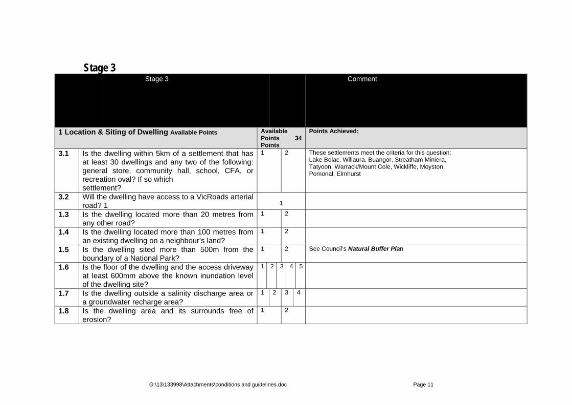
Stage 3 Stage 3 Comment
1 Location & Siting of Dwelling Available Points
Available Points 34 Points
Points Achieved:
3.1 Is the dwelling within 5km of a settlement that has at least 30 dwellings and any two of the following: general store, community hall, school, CFA, or recreation oval? If so which settlement?
1 2 These settlements meet the criteria for this question: Lake Bolac, Willaura, Buangor, Streatham Miniera, Tatyoon, Warrack/Mount Cole, Wickliffe, Moyston, Pomonal, Elmhurst
3.2 Will the dwelling have access to a VicRoads arterial road? 1
1
1.3 Is the dwelling located more than 20 metres from any other road?
1 2
1.4 Is the dwelling located more than 100 metres from an existing dwelling on a neighbour’s land?
1 2
1.5 Is the dwelling sited more than 500m from the boundary of a National Park?
1 2 See Council’s Natural Buffer Plan
1.6 Is the floor of the dwelling and the access driveway at least 600mm above the known inundation level of the dwelling site?
1 2 3 4 5
1.7 Is the dwelling outside a salinity discharge area or a groundwater recharge area?
1 2 3 4
1.8 Is the dwelling area and its surrounds free of erosion?
1 2
G:\13\133998\Attachments\conditions and guidelines.doc Page 12
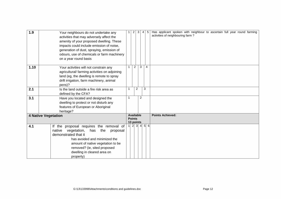
1.9 Your neighbours do not undertake any activities that may adversely affect the amenity of your proposed dwelling. These impacts could include emission of noise, generation of dust, spraying, emission of odours, use of chemicals or farm machinery on a year round basis
1 2 3 4 5 Has applicant spoken with neighbour to ascertain full year round farming activities of neighbouring farm ?
1.10 Your activities will not constrain any agricultural/ farming activities on adjoining land (eg, the dwelling is remote to spray drift irrigation, farm machinery, animal pens)?
1 2 3 4
2.1 Is the land outside a fire risk area as defined by the CFA?
1 2 3
3.1 Have you located and designed the dwelling to protect or not disturb any features of European or Aboriginal heritage?
1 2
4 Native Vegetation
Available Points 13 points
Points Achieved:
4.1 If the proposal requires the removal of native vegetation, has the proposal demonstrated that it
has avoided and minimized the amount of native vegetation to be removed? (ie, sited proposed dwelling in cleared area on property)
1 2 3 4 5 6

G:\13\133998\Attachments\conditions and guidelines.doc Page 13
4.2 If the proposal requires native vegetation to be removed, has the proposal provided sufficient offsets for the removed native vegetation and habitat?
1 2 3 4
Have you located the dwelling to minimize its impacts on native vegetation along natural drainage channels?
1 2 3
5 Services
Available Points 27 points
Points Achieved:
5.1 Is the proposed dwelling connected or has access to telephone and communication services?
1 2
5.2 Is the proposed dwelling connected to reticulated power source, or has a nominated alternative supply?
1 2
6.1 Does the proposal include a land capability assessment (LCA) report that demonstrates the suitability of the on-site effluent treatment?
1 2 3 4 5
6.2 Are the septic disposal lines (secondary effluent envelope) located more than 100 metres from any watercourse, wetlands or designated flood plain?
1 2 3 4
7.1A Is the proposed dwelling located more than 60 metres from any natural drainage channel?
1 2
7.1B Have you used the natural drainage channels including open swales to minimize erosion?
1 2 3

G:\13\133998\Attachments\conditions and guidelines.doc Page 14
7.1C
Have you integrated the natural drainage into proposals to restore native vegetation??
1
16
Does the proposal include a net reduction in the area of earthworks on the lot? 1 2 3 4 5
1
2
3
4
5
8.1A Is the dwelling provided with reticulated town water and fire fighting capacity or at least a 20,000 litre water tank and a minimum 10,000 litre reserve for fire fighting.
1 2 3
9 Design of the dwelling and outbuildings
Available Points 22 points
Points Achieved:
9.1 Are the proposed building materials of muted and /or earthy tones and non reflective materials?
1 2
9.2 Is the peak of the roof of the dwelling below any crest or ridges on the land?
1 2 3 4
9.3 Is the amount of external shedding less than 100 square metres, including areas under verandahs (exclude shedding required for farm activities)?
1 2
11 Architectural iconic features and other colours or tones are supported by a review by an independent architect or urban designer.
1
12 Is the dwelling sited and designed to maximise natural daylight?
1 2 3
13 Is the dwelling is sited and designed to maximise natural heating and cooling.
1 2
15 Does the proposal include a net reduction in the floor area of outbuildings on the lot?
1 2 3

G:\13\133998\Attachments\conditions and guidelines.doc Page 15
18 Does the proposal include Solar energy panels and / or wind energy turbine
1 2 3
20 Does the proposal include active solar heating technologies? 1 2
1 2
10 Farm Management Plan
Available Points 44
Points Achieved:
10.1 If the land rated as moderate or high in terms of agricultural versatility by the Ararat Rural City Land Capability Pilot Project Vol 1 May 2005 (Department of Primary Industries) is the proposal supported by a Farm Management Plan. The Farm Management Plan must adequately address the following details:
Ararat Rural City Land Capability Pilot Project Vol 1 May 2005 (Department of Primary Industries)
10.1A • A1 Site Plan and written document citing the Location and description of the land and siting of the proposed dwelling and the following aspects
1 2 3
10.1B • Natural features including: Climate; Landform; Soils; Water supply; Vegetation type and density ; Land capability statement
1 2 3 4
10.1C • Proposals for any productive activities on the land: Crops or herds; Improvements such as
fencing, buildings, earthworks; Revegetation; Improvements to water supply.
1 2 3 4 5 6
10.1D • Capital expenditure: Buildings; Works including fencing, earthworks; Staging of proposed farming activity
1 2 3 4

G:\13\133998\Attachments\conditions and guidelines.doc Page 16
10.1E • Realistic forecast yields and income of proposal.
1 2 3
10.1F • Planning considerations: Timing and sequencing; Inspections and monitoring; Impacts on neighbours; Impacts of neighbours activities; Weed and pest control; Need for permanent residence
1 2 3 4 5 6
10.3 Are you prepared to start agricultural activities outlined in the Farm Management Plan prior to commencement of construction of the proposed dwelling?
1 2 3 4 Will require a section 173 agreement (Planning & Environment Act 1987.
10.4 What proportion (%) of the land will be covered by agricultural productive activities?
1 2 3 4 5 6
14 Is it proposed to enter into any legally binding arrangements (or are in any in place) to replace and protect native vegetation including Trust for Nature?
1 2 3 4
19 Is the area to be included in Trust for Nature at least 20% of the land and an area of 5 hectares?
1 2 3 4
Land Management Plan
Available Points 44
Points Achieved:

G:\13\133998\Attachments\conditions and guidelines.doc Page 17
The Land Management Plan should be provided with the planning application if it is intended to develop a dwelling and undertake conservation activities rather than productive agricultural activities. The Land Management Plan adequately address the following matters:
• A1 Site Plan and written document citing the Location and description of the land and siting of the proposed dwelling and the following aspects
1 2 3
• Natural features including: Climate; Landform; Soils; Water supply; Vegetation type and density ; Land capability statement
1 2 3
• Proposals for any productive activities on the land: Crops or herds; Improvements such as fencing, buildings, earthworks Separation of herds from conservation areas.
1 2 3 4
• Proposals for conservation identifying habitats, species, waterways, parts of the land affected.
1 2 3 4 5 6
• Capital expenditure: Revegetation and plantings, buildings; works including fencing, earthworks; staging of proposed conservation and revegetation activities
1 2 3
• Measures to control feral animals and weeds.
1 2 3 4

G:\13\133998\Attachments\conditions and guidelines.doc Page 18
• Timing and sequencing; Inspections and monitoring; Impacts on neighbours; Impacts of neighbours activities; Need for permanent residence
1 2 3 4
• Why these proposals provide a better outcome than using the land for agricultural
production.
1 2 3
Are you prepared to start conservation and revegetation activities outlined in the Land Management Plan prior to commencement of construction of the proposed dwelling?
1 2 3 4
What proportion (%) of the land will be covered by conservation activities?
1 2 3 4
Is it proposed to enter into any legally binding arrangements (or are in any in place) to replace and protect native vegetation including Trust for Nature?
1 2 3
What proportion of the land is proposed to be bound to Trust for Nature?
1 2 3
2.1.1 YOU NEED AT LEAST 100 POINTS FOR FAVOURABLE CONSIDERATION Total Possible `Points for Stage 3:: 140

G:\13\133998\Attachments\conditions and guidelines.doc
Page 1
Other available guidelines Currently available guidelines and checklists for small rural lot or dwelling in farming zone applications Council and Hyperlink Brief description of requirements
South Gippsland http://www.southgippsland.vic.gov.au/files/Checklist_Farming_Zone.pdf
Application checklist for farming zone dwellings ‐ An application form completed and
signed, ‐ A current copy of title for the land, no
more than 60 days old, ‐ Three copies of all plans drawn at
preferred scales of 1:100 or 1:200, ‐ a written statement which explains
how the proposed dwelling responds to the decision guidelines for dwellings in the Farming Zone
Colac Otway’s http://www.colacotway.vic.gov.au/Files/Planning__Farming_Zone_New_Dwellings.pdf
Farming zone new dwellings ‐ Full details of the current and future
agricultural activities on the land including how long the operation has been established, the extent of the operation (ie. what other nearby land is in the same ownership) plans for expansion/intensification, current and proposed staffing levels and any other relevant information to support your application.
‐ Details of any existing dwellings on the property and the relationship of the occupants to the farming enterprise.
‐ Why permanent on-site management is required for the agricultural activities,
‐ How the particular dwelling site has been selected to minimise adverse impacts on the ability to farm the land
‐ How the dwelling will be supplied with all weather access, power, water and waste disposal
‐ Acknowledgement of the need to enter into an agreement under Section 173 of the Planning and Environment Act 1987 to prevent excision of the dwelling
Horsham http://www.hrcc.vic.gov.au/attachments/article/157/DwellingsChecklist.pdf
Dwellings or out buildings in the farming zone ‐ A Planning Permit Application form
completed and signed. ‐ A current copy of Title and Title Plan
including any Covenants and/or Section 173 Agreements applicable to the land
‐ A completed Cultural Heritage

G:\13\133998\Attachments\conditions and guidelines.doc
Page 2
Management Plan checklist form. ‐ The prescribed application fee.
Mitchell Shire http://www.mitchellshire.vic.gov.au/downloads/Council_Services/Statutory_Planning/Planning_permit_checklist_Dwellings_in_the_farming_zone.pdf
Checklist for planning applications to construct dwellings and dwelling extension in the farming zone
‐ An Application Form completed and signed
‐ A current copy of Title for the land, no older than three months
‐ This can be downloaded from: www.land.vic.gov.au
‐ The prescribed Application Fee ‐ A signed cover letter advising what is
being proposed Moorabool http://www.moorabool.vic.gov.au/CA257489001FD37D/Lookup/Checklist/$file/Checklist9.pdf
Use and development of a dwelling in the farming zone
‐ An Application form completed and signed ‐ A full current copy of Title for the land,
including the map showing current ownership details, title plan and a full copy of any registered covenants, restrictions or Section 173 Agreements that apply to the land
‐ The prescribed application fee ‐ Fully dimensioned plans
Latrobe http://www.latrobe.vic.gov.au/Services/PlanningServices/PlanningPermitsStatutoryPlanning/
Planning Permits & Statutory Planning This includes,
‐ considering proposals to subdivide, use and or develop land, and giving notices and issuing permits in accordance with the planning scheme
‐ making sure that land is not used or developed in conflict with the scheme's requirements, for example, by a person starting a car wrecking business on a residential block
‐ issuing certificates about the zoning and controls on land
Greater Shepparton www.greatershepparton.com.au/download.asp?RelatedLinkID=4845
Rural dwellings ‐ A completed and signed ‘Application for
Planning Permit Form’ ‐ A Full Current Copy of Title ‐ The prescribed fee ‐ Covering letter ‐ Describe the contents of your application
and also the details of any pre-application discussions with a planning officer and neighbours.
‐ A statement explaining how the proposed dwelling responds to the decision guidelines for a dwelling in the zone (FZ only). This is a mandatory requirement of
G:\13\133998\Attachments\conditions and guidelines.doc
Page 3
the Farming Zone. The decision guidelines include:
o Whether the dwelling will result in the loss or fragmentation of productive agricultural land.
o Whether the dwelling is reasonably required for the operation of the agricultural activity conducted on the land.
o Whether the dwelling will be adversely affected by agricultural activities on adjacent and nearby land due to dust, noise, odour, use of chemicals and farm machinery, traffic and hours of operation.
o Whether the dwelling will adversely affect the operation and expansion of adjoining and nearby agricultural uses.
o The potential for the proposal to lead to a concentration or proliferation of dwellings in the area and the impact of this on the use of the land for agriculture.
‐ Plans Baw Baw http://www.bawbawshire.vic.gov.au/files/c851f0be-122d-429b-84d7-9fbb00ee9864/Rural_dwelling_checklist.pdf
Application checklist for rural dwellings ‐ An application form completed and signed ‐ A current copy of title for the land showing
the plan of subdivision ‐ The prescribed application fee ‐ Any registered restrictive
covenant/planning agreement pertaining to the application land
‐ Buildings and works ‐ Three copies of all plans drawn at
preferred scales of 1:100 or 1:200 (A4 or A3 in size)
Mt Alexander http://planning.mountalexander.vic.gov.au/OPMEXT/public/documents/Planning_Permit_General_Application_Checklist.pdf
Planning permit application checklist for dwellings, sheds, garages, and other applications
‐ Completed Planning Permit Application form
‐ Application fee paid when lodging your application
‐ Current copy of the property Title. Titles have two sections and Planning needs both:
‐ A3 Site Plans