1. name of property 2. location 3. classification draft · was popular for highway and railroad...
TRANSCRIPT
DRAFTNPS Form 10-900 USDI/NPS NRHP Registration Form (Rev. 8-86) OMB No. 1024-0018 WEST UNION BRIDGE Page 1 United States Department of the Interior, National Park Service National Register of Historic Places Registration Form
1. NAME OF PROPERTY Historic Name: West Union Bridge Other Name/Site Number: World Guide #14-61-27; Parke County Covered Bridge #26 2. LOCATION Street & Number: Spanning Sugar Creek at bypassed section of Tow Path Road/CR525W Not for Publication: City/Town: West Union vicinity, Reserve Township Vicinity: X State: Indiana County: Parke Code: 061 Zip Code: 47862 3. CLASSIFICATION
Ownership of Property Category of Property Private: __ Building(s): __ Public-Local: X District: __ Public-State: __ Site: __ Public-Federal: __ Structure: X
Object: __ Number of Resources within Property Contributing Noncontributing buildings buildings sites sites 1 structures structures objects objects 1 Total 0 Total Number of Contributing Resources Previously Listed in the National Register: 1 Name of Related Multiple Property Listing:

NPS Form 10-900 USDI/NPS NRHP Registration Form (Rev. 8-86) OMB No. 1024-0018 WEST UNION BRIDGE Page 2 United States Department of the Interior, National Park Service National Register of Historic Places Registration Form
4. STATE/FEDERAL AGENCY CERTIFICATION As the designated authority under the National Historic Preservation Act of 1966, as amended, I hereby certify that this ____ nomination ____ request for determination of eligibility meets the documentation standards for registering properties in the National Register of Historic Places and meets the procedural and professional requirements set forth in 36 CFR Part 60. In my opinion, the property ____ meets ____ does not meet the National Register Criteria. Signature of Certifying Official Date State or Federal Agency and Bureau In my opinion, the property ____ meets ____ does not meet the National Register criteria. Signature of Commenting or Other Official Date State or Federal Agency and Bureau 5. NATIONAL PARK SERVICE CERTIFICATION I hereby certify that this property is: ___ Entered in the National Register ___ Determined eligible for the National Register ___ Determined not eligible for the National Register ___ Removed from the National Register ___ Other (explain) Signature of Keeper Date of Action

NPS Form 10-900 USDI/NPS NRHP Registration Form (Rev. 8-86) OMB No. 1024-0018 WEST UNION BRIDGE Page 3 United States Department of the Interior, National Park Service National Register of Historic Places Registration Form
6. FUNCTION OR USE Historic: Transportation Sub: road-related (vehicular bridge) Current: Transportation Sub: road-related (pedestrian bridge) 7. DESCRIPTION ARCHITECTURAL CLASSIFICATION: Other: Burr truss covered bridge MATERIALS:
Foundation: stone Walls: wood Roof: metal Other:

NPS Form 10-900 USDI/NPS NRHP Registration Form (Rev. 8-86) OMB No. 1024-0018 WEST UNION BRIDGE Page 4 United States Department of the Interior, National Park Service National Register of Historic Places Registration Form
Summary Built in 1876 by Joseph John (“J.J.”) Daniels, one of the nation’s most prolific covered bridge builders, West Union Bridge is an outstanding, intact example of the Burr truss, a highly-significant and widely-used American timber bridge type.1 Patented by Theodore Burr in 1817, the Burr truss combined the strengths of a traditional multiple-kingpost truss with segmented arches to allow for a long, sturdy span with a level deck.2 The design was popular for highway and railroad bridges for over a century and about 180 examples survive, with some of the finest examples located in Pennsylvania and Indiana; of these, West Union Bridge is noteworthy for its picturesque setting, outstanding construction and high level of integrity. West Union Bridge was built on-site using traditional nineteenth-century timber-framing methods and has occupied the same site since its construction. After carrying traffic for nearly a century, the structure was bypassed in 1964, but has been preserved in place as a local historic landmark and tourist attraction. West Union Bridge retains an uncommonly high level of integrity in location, setting, design, materials, workmanship, feeling, and association. West Union Bridge is nationally significant under NHL Criterion 4 (a property that embodies the distinguishing characteristics of an architectural type specimen exceptionally valuable for a study of a period, style, or method of construction), NHL Theme V (Developing the American Economy), Subtheme 3 (Transportation and Communications) and NHL Theme VI (Expanding Science and Technology), Subtheme 2 (Technological Applications). In 1978, the structure was listed in the National Register of Historic Places as part of the “Parke County Covered Bridges Thematic Resource” nomination. The structure was documented by the Historic American Engineering Record (HAER) with a history and photographs in 2002 and with measured drawings in 2013. Of the approximately 690 historic (pre-1955) covered bridges surviving in the United States, West Union Bridge stands out as a superb example of covered bridge construction and preservation.3 Describe Present and Historic Physical Appearance. Setting West Union Bridge is a prominent local landmark and rare surviving reminder of the nineteenth-century development of Parke County and the Wabash River Valley. The crossing was originally established as part of a state road that extended through the Wabash River Valley from Terre Haute to Fort Wayne. The bridge is located in a picturesque rural setting about one mile north of the unincorporated hamlet of West Union in Reserve Township, Parke County, Indiana.4 The bridge carries a bypassed section of Towpath Road/CR525W over Sugar Creek. The north-south crossing is located between the intersections of English Road, one-quarter of a mile to the north, and Ten O’clock Road/CR210W, three-quarters of a mile to the south. Today, the surrounding area is largely active farmland with scattered farmsteads and houses along the public roadways.
1 A truss is a structure built up of relatively small members, combined in a series of interconnected triangles, to form a rigid
framework. 2 Some contemporary sources refer to Theodore Burr’s design as a “Burr arch” or “Burr arch-truss,” but Burr’s 1817 patent calls it
a truss and the term “Burr truss” has long been used by experts in the field. See: John C. Trautwine, The Civil Engineer’s Pocket-Book (Philadelphia: E. Claxton, 1883), 289; Robert Fletcher and J.P. Snow, “A History of the Development of Wooden Bridges,” Transactions of the American Society of Civil Engineers 99 (1934): 328; Richard Sanders Allen, Covered Bridges of the Northeast (Brattleboro, Vermont: Stephen Greene Press, 1957), 14; David Plowden, Bridges: the Spans of North America (New York: W.W. Norton & Co., 1974), 39; Joseph D. Conwill, “Burr Truss Bridge Framing,” Timber Framing 78 (December 2005): 4.
3 Approximately half of the extant historic (pre-1955) covered bridges in the United States have been significantly altered, with much loss of historic fabric and character.
4 Reserve Township was so-named because much of the land was once part of an American Indian reservation.

NPS Form 10-900 USDI/NPS NRHP Registration Form (Rev. 8-86) OMB No. 1024-0018 WEST UNION BRIDGE Page 5 United States Department of the Interior, National Park Service National Register of Historic Places Registration Form
Sugar Creek originates near Kempton, Indiana, and travels in a southwesterly direction approximately 93 miles to its confluence with the Wabash River, about one mile west of West Union Bridge. In 1828, the Indiana State Legislature authorized construction of a road through the Wabash River Valley from Terre Haute to Fort Wayne. Completed by 1833, the road , crossed Sugar Creek near this site. was under county jurisdiction.5 No information has been found concerning details of the original Sugar Creek crossing, but there would have been at least a ford—if not a bridge—at this site when the road was built. Historical records suggest that local road districts maintained the corridor from the time of its construction.6 West Union Bridge is the third county-built bridge at, or near, this site. While this crossing was once part of an important regional transportation corridor, there are few structures within sight of the covered bridge, except the adjacent modern bridge and a nineteenth-century farm a short distance to the north. The surrounding landscape consists of farm fields bordered by woodland. The bridge is located about ten miles northwest of Rockville, the seat of Parke County, and one mile north of West Union, which was first settled in 1822 and flourished in the mid-nineteenth century as an agricultural shipping point on the Wabash & Erie Canal and later, the Chicago & Eastern Illinois Railroad. Today, West Union comprises about a dozen houses and established farms surrounding a nearly-triangular cornfield bordered by Towpath Road/CR525W on the west, Ten O’clock Road/CR210W on the east and River Road/ CR500N on the south. A timber railroad bent at the intersection of Towpath Road and Ten O’clock Road marks the former railroad corridor, but the former canal and railroad corridors have been largely reclaimed into the surrounding farmland.7 Description8 West Union Bridge is a two-span through truss covered wood bridge on a stone masonry pier and abutments.9 The north span crosses the main channel of Sugar Creek, while the south span crosses the flood plain of Sugar Creek. The superstructure is approximately 346 feet long (along the ridge), 17 feet wide (eave-to-eave) and 22 feet deep (bottom of floor beams to top of roof), with clear-span lengths of 152 feet each, a roadway width of 11 feet and overhead clearance of 8 feet. The trusses are approximately 20 feet deep and spaced 15 feet apart. The mortared stone abutments and pier are built of rough-faced, coursed ashlar and rise approximately 20 feet above the normal level of Sugar Creek. The pier has a cutwater on its upstream side. The north approach, which slopes down to the bridge, is about 20 feet long with concrete retaining walls. Beyond the approach, a portion of the old roadway extends approximately 350 feet northwest to its intersection with Towpath Road/CR525W. The south approach, which slopes up to the bridge, is about 65 feet long with 3-foot high concrete parapets. A cast concrete plaque in the east wall is inscribed with the date “1914” and the names of the county officials in charge of rebuilding the approach following the flood of 1913.
5 Stan Sinclair, Illustrated Guide to Parke County Covered Bridges (Rockville, Indiana: by author, 1991), 138-141; George E.
Gould, Indiana Covered Bridges Thru the Years (Indianapolis: Indiana Covered Bridge Society, Inc., 1977), 40. 60 and 104. 6 In June of 1854, the Parke County Commissioners authorized construction of a covered bridge on the state road at Armiesburg,
indicating that the county had jurisdiction over the road and any associated crossings within its borders by that date. Sinclair, 104. 7 The Brazil Division of the Chicago & Eastern Illinois Railroad crossed Sugar Creek about a half-mile east of the covered bridge.
The railroad line was abandoned in 1941 and the tracks were subsequently removed, but the alignment of the corridor can still be seen on late-twentieth century topographic maps.
8 Dimensions were obtained from the 2002 HAER history, the 2013 HAER measured drawings (see appendix), and measurements taken on-site by the author.
9 In a through truss (sometimes called a high truss or overhead truss) the length of the span requires deep trusses with lateral bracing overhead, so that traffic passes through the structure.

NPS Form 10-900 USDI/NPS NRHP Registration Form (Rev. 8-86) OMB No. 1024-0018 WEST UNION BRIDGE Page 6 United States Department of the Interior, National Park Service National Register of Historic Places Registration Form
The truss design is a very fine example of the Burr truss plan, which combines a conventional multiple-kingpost truss with superimposed segmented arches, so that the arch and truss work in tandem to support moving loads. In West Union Bridge, each truss is made up of sixteen 9’-6” wide panels. The top chords comprise a single line of 7”x12” timbers butted end-to-end. The bottom chords comprise two lines of 6”x12” timbers butted end-to-end and connected to each other with fish plates and shear blocks. The top and bottom chords are connected by vertical posts, which taper from 7”x8” at each end to 7”x12” at the middle, and 7”x9” diagonal braces angling down towards the ends of the bridge between the posts. The top and bottom chords are notched around the posts. The ends of the diagonal braces frame into the posts by means of a notch cut near the top and bottom of each post. A 1”-diameter metal tension rod connects the end posts of the two spans about a foot below the top chord on each side of the bridge; this feature allows the spans to act continuously over the pier. Each truss is sandwiched between, and bolted to, a pair of segmented, concentric arches.10 The arches spring from about 5 feet below the bottom chords, rise 25 feet to the crown and span approximately 152 feet. Each arch is built up of 6”x11” timber segments butted together and secured with ¾”-diameter threaded rods at every other post. The arches are snug against the trusses at the crown and the ribs gradually splay out away from the trusses (by means of spacer blocks) toward the end of each span, enabling each pair of arches to fit around the bottom chords, rather than using lap joints with their attendant loss of material; thus, each pair of arches is spaced approximately 7 inches apart (the thickness of the truss) at the crown, while at the skewbacks, each pair of arches is spaced approximately 16 inches apart (a little more the thickness of the bottom chords).11 At the abutments, the arches bear on cast iron plates embedded in the masonry; this feature was intended to prevent rot at the ends of the arch. There are 4”x12” transverse floor beams seated on the bottom chords, two per panel, over the length of the bridge. Twelve lines of 3”x6” stringers are laid longitudinally on top of the floor beams. A two-layer wood deck, comprising a layer of 2”-thick, random-width longitudinal boards on top of a layer of 2”-thick, random-width transverse boards is fastened on top of the stringers. The deck is continuous over the center pier. There are wood guardrails along the inside of the trusses made up of 2”x16” planks butted end-to end and nailed to the posts about two feet above the deck. The lower lateral bracing system comprises 1”-diameter transverse tie rods between the bottom chords at each panel point and 5”x7” wood cross-bracing between the tie rods; the ends of the tie rods pass through cast iron shoes attached to the inner face of the chords and the cross braces bear against them. Iron eye-hooks mortared into the abutments and pier anchor a 1½”-diameter iron stay rod fastened to the bottom chord at each corner of each span; the rods help to secure the superstructure in the event of a flood.12 The upper lateral bracing system comprises 1”-diameter transverse tie rods between the top chords at each panel point and 5”x7” wood cross-bracing between the tie rods; the ends of the tie rods pass through cast iron shoes attached to the inner face of the chords and the cross-braces bear against them. The 5/12-pitch gable roof comprises 2”x4” rafters supporting a galvanized metal roof laid over skip sheathing. The roof is continuous over the center pier. The bridge is housed with board-and-batten siding fastened to 2”x4” nailers on the outside of the trusses. The portals are covered with vertical plank siding and the portal openings are arched. Two-foot deep openings at the eaves allow light and air into the structure. There is a 10-foot long shelter panel at the north end of the bridge and a 17-foot long shelter panel at the south end of the bridge. There
10 The arches are both segmented and segmental. They are segmented in terms of their construction (i.e. they are built up of
individual timber segments butted together); they are segmental in terms of their shape (i.e. the arc of the arch is a segment of a circle).
11 See HAER drawing sheets 5 and 7 and HAER photographs IN-105-9 and IN-105-15 in appendix. 12 These tie rods can be found in many of J.J. Daniels’ surviving covered bridges.

NPS Form 10-900 USDI/NPS NRHP Registration Form (Rev. 8-86) OMB No. 1024-0018 WEST UNION BRIDGE Page 7 United States Department of the Interior, National Park Service National Register of Historic Places Registration Form
are windows on the west side of the bridge, two per span; these window openings are framed into the siding and each opening is protected by a wood awning to keep precipitation from directly entering the bridge. The windows allow additional light and air into the bridge; they were added at an unknown date in the 1940s or 50s. The bridge is painted barn red, with white portals. The following inscription is painted on the tympanum above each portal: “1876/ J.J. DANIELS/ WEST UNION/ CROSS THIS BRIDGE AT A WALK.” Integrity Due to its sturdy construction and its location on a rural road, West Union Bridge has required few alterations or modifications since its erection and the structure retains its historic integrity. In 1913-14, the pier and abutments were repaired and the south approach was rebuilt following a flood. In 1976, the trusses were repaired, but no written records have been found concerning those repairs.13 The siding, roof and deck have been replaced periodically as part of routine maintenance; replacement of the housing components and wearing surface of the deck generally does not diminish the integrity of the structure. The bridge originally had a wood shingle roof; the present roof is galvanized metal. The bridge was originally unpainted, but it has been painted barn red with white portals since the 1940s.14 Due to the angle of the approach to the bridge, the north portal was modified in the mid-twentieth century after being damaged by a vehicle, or vehicles; a 1961 photograph shows a squared opening with new siding.15 The portal was returned to its original arched appearance sometime prior to 2002, when HAER documented the structure.16 West Union Bridge carried traffic for 88 years before being bypassed in 1964. The bridge was subsequently closed to traffic and preserved in place as a local historic landmark. The north approach, inclined down toward the bridge, is largely intact, but shows evidence of erosion. The north portal is blocked by a simple metal post-and-rail barricade. The west approach, inclined up toward the bridge, is largely intact, although the adjacent portion of the former roadway has been subsumed into the surrounding farm field. The bridge’s overall appearance and rural setting have changed slightly from the time of bridge’s construction, but the structure still retains the feeling of a nineteenth-century covered bridge.
13 Charles Felkner, “Parke County Covered Bridges Thematic Resource,” National Register Nomination (Washington, DC: U.S.
Department of the Interior, National Park Service, 1978), Section 7, 3. 14 Most covered bridges were left unpainted until the mid-twentieth century, when painting them became common practice;
approximately one-third of the nation’s covered bridges were painted red during that era. Joseph D. Conwill, “The Red Covered Bridge: Fiction Affects Fact,” unpublished typescript, July 26, 2004.
15 Jesse Lunger, Photograph of West Union Bridge, 1961, Richard Sanders Allen Collection, National Society for the Preservation of Covered Bridges Archives, Penacook, New Hampshire.
16 See HAER photographs in appendix.

NPS Form 10-900 USDI/NPS NRHP Registration Form (Rev. 8-86) OMB No. 1024-0018 WEST UNION BRIDGE Page 8 United States Department of the Interior, National Park Service National Register of Historic Places Registration Form
8. STATEMENT OF SIGNIFICANCE Certifying official has considered the significance of this property in relation to other properties: Nationally: X Statewide: __ Locally: __ Applicable National Register Criteria: A B C X D__ Criteria Considerations (Exceptions): A B C D E F G__ NHL Criteria: 4 NHL Theme(s): V. Developing the American Economy 3. Transportation and Communications VI. Expanding Science and Technology 2. Technological Applications Areas of Significance: Transportation Engineering Period(s) of Significance: 1876 Significant Dates: 1876 Significant Person(s): N/A Cultural Affiliation: N/A Architect/Builder: Joseph J. Daniels, Rockville, Indiana Historic Contexts: Covered Bridges NHL Context Study XVII. Technology (Engineering and Innovation) B. Transportation

NPS Form 10-900 USDI/NPS NRHP Registration Form (Rev. 8-86) OMB No. 1024-0018 WEST UNION BRIDGE Page 9 United States Department of the Interior, National Park Service National Register of Historic Places Registration Form
State Significance of Property, and Justify Criteria, Criteria Considerations, and Areas and Periods of Significance Noted Above. Built in 1876 by Joseph John (“J.J.”) Daniels, one of the nation’s most prolific covered bridge builders, West Union Bridge is an outstanding, intact example of the Burr truss, a highly-significant and widely-used American timber bridge type. Patented by Theodore Burr in 1817, the Burr truss combined the strengths of a traditional multiple-kingpost truss with segmented arches to allow for a long, sturdy span with a level deck. The design was popular for highway and railroad bridges for over a century and about 180 examples survive, with some of the finest examples located in Pennsylvania and Indiana; of these, West Union Bridge is noteworthy for its picturesque setting, outstanding construction and high level of integrity. West Union Bridge was built on-site using traditional nineteenth-century timber-framing methods and has occupied the same site since its construction. After carrying traffic for nearly a century, the structure was bypassed in 1964, but has been preserved in place as a local historic landmark and tourist attraction. West Union Bridge retains an uncommonly high level of integrity in location, setting, design, materials, workmanship, feeling, and association. West Union Bridge is nationally significant under NHL Criterion 4 (a property that embodies the distinguishing characteristics of an architectural type specimen exceptionally valuable for a study of a period, style, or method of construction), NHL Theme V (Developing the American Economy), Subtheme 3 (Transportation and Communications) and NHL Theme VI (Expanding Science and Technology), Subtheme 2 (Technological Applications). In 1978, the structure was listed in the National Register of Historic Places as part of the “Parke County Covered Bridges Thematic Resource” nomination. The structure was documented by the Historic American Engineering Record (HAER) with a history and photographs in 2002 and with measured drawings in 2013. Of the approximately 690 historic (pre-1955) covered bridges surviving in the United States, West Union Bridge stands out as a superb example of covered bridge construction and preservation. A discussion of the national significance of the West Union Bridge is provided in the associated document, Covered Bridges NHL Context Study (2012). The study establishes the history and evolution of the property type, and provides a preliminary assessment of the National Historic Landmark (NHL) eligibility of structures that are considered by experts in the field to be the best representative examples of covered timber bridges in the United States. These properties were selected from the National Covered Bridges Recording Project, undertaken in 2002-2005 by the Historic American Engineering Record (HAER), which is administered by the Heritage Documentation Programs (HDP) Division of the National Park Service, United States Department of the Interior. The project was funded by the Federal Highway Administration’s (FHWA) National Historic Covered Bridge Preservation (NHCBP) Program, established in 2000 by Section 1224 of the Transportation Equity Act for the 21st Century (TEA21). Over the course of a multi-year project, HAER recorded 86 covered bridges throughout the United States. In 2010, each of these bridges was individually evaluated against National Historic Landmark criteria and a list compiled of twenty covered bridges that have high integrity and are significant as outstanding representative examples of their type, period, and method of construction. Secondary considerations for inclusion in this list were: historical significance of the bridge and/or site, significance of the designer or builder, and aesthetics of the bridge and site.17 Covered Bridges in the United States Covered bridges are pre-eminently—although not exclusively—an American phenomenon. Nowhere else in the world were such impressive timber structures attempted, and nowhere else were they built in such large
17 Lola Bennett, “Covered Bridges NHL Context Study,” (Washington, DC: U.S. Department of the Interior, National Park
Service, 2012), <http://www.nps.gov/nhl/learn/specialstudies/CoveredBridges.pdf>.

NPS Form 10-900 USDI/NPS NRHP Registration Form (Rev. 8-86) OMB No. 1024-0018 WEST UNION BRIDGE Page 10 United States Department of the Interior, National Park Service National Register of Historic Places Registration Form
numbers.18 Over the course of two centuries, covered bridges have played a significant role in American life, by facilitating settlement, transportation and commerce. They also represent a period of remarkable achievement in civil engineering, during which bridge building evolved from an empirical craft to a science. Timber bridges have been built in forested regions of the world for centuries.19 Wood is an excellent material for building; it is strong, relatively lightweight, and easy to work with. Since most species of wood suitable for structural applications deteriorate rapidly when exposed to the weather, European bridge builders quickly learned the value of covering wood bridges with roofs and siding to protect the underlying framework.20 Bridges were rare in Colonial America. Small streams were spanned with simple wood beams or stone slabs, and occasionally with stone arches, but with few exceptions, larger waterways had to be crossed by ford or ferry. Travel was hazardous and uncertain; delays and accidents were common. A few ambitious crossings were made with pontoons or a series of simple beam spans supported on timber piles, but long-span bridges were generally not built in America until the volume of transportation justified the expenditure of material and labor.21 Following the American Revolutionary War, the demand for roads and bridges, coupled with access to abundant forests, spurred the development of timber bridge design in the United States. Internal improvements were a priority of the new nation. Roads, canals and bridges were desperately needed to expand commerce and unite the country. The Louisiana Purchase of 1803 doubled the land area of the United States and over the next half-century, settlement expanded west to the Pacific Ocean. Timber bridges were an ideal solution to America’s many transportation hurdles and hundreds of them were built as waves of settlement pushed westward across the continent. They provided for safe, efficient and economical overland transportation that was essential to the new nation’s growth. In 1804-05, Timothy Palmer (1751-1821) built America's first covered bridge across the Schuylkill River at Philadelphia. By 1810, covered bridges were common in southern New England, southeastern New York, Pennsylvania and New Jersey. From this core area, covered bridges spread northward, southward and westward. In the 1820s, town and county governments began to specify covered bridges for construction on local roads. By 1830, covered bridges were commonplace at major river crossings in the eastern United States. The builders of timber bridges utilized readily available materials and traditional hand tools. Making use of patented truss designs, a team of carpenters could erect an average-sized covered bridge in a short time, usually within a few weeks. Covered bridges were adapted to the needs of every type of transportation corridor, including turnpikes, canals and railroads and they facilitated the settlement of the United States for over a century. The rapid growth of the railroads in the mid-1800s—in particular, the increasing weight of locomotives and rolling stock—encouraged innovations and technical advancements in the design of timber truss bridges and was an important factor in the
18 According to the 7th edition of the World Guide to Covered Bridges (2009), there are approximately 1,500 extant historic (pre-
1955) covered bridges in the world; nearly half of these structures are located in the United States. American scholars have recently become aware of large numbers of ancient covered bridges in China, but most were built for pedestrian traffic, and their construction techniques and reason for covering differ from the Western tradition.
19 In 55 BC, forces under Julius Caesar (100 BC-44 BC) built the earliest known timber bridge across the Rhine River. 20 Several European covered bridges have survived for more than three centuries, while a few in the United States are nearing the
two-century mark. 21 The Great Bridge (1660) across the Charles River at Boston, Massachusetts, and the York River Bridge (1761) at York, Maine,
were notable exceptions. The Great Bridge consisted of “cribs of logs filled with stone and sunk in the river—hewn timber being laid across it.” The York River Bridge was a timber pile bridge, which uses tree trunks or piles driven vertically into the river bed to provide a foundation for a series of simple beam spans.

NPS Form 10-900 USDI/NPS NRHP Registration Form (Rev. 8-86) OMB No. 1024-0018 WEST UNION BRIDGE Page 11 United States Department of the Interior, National Park Service National Register of Historic Places Registration Form
rise of civil engineering as a profession. All the major technological improvements in American truss bridge design occurred when wood was the building material of choice. By 1850, there were covered bridges in most settled regions of the United States.22 Thereafter, the number of covered bridges continued to multiply until about 1870, by which time there were well over 10,000 covered bridges in the United States.23 The golden era of covered bridge building lasted for about a century in most regions of the United States, and even longer in areas where timber was plentiful.24 Theodore Burr Theodore Burr (1771-1822) is a highly significant figure in the history of covered bridge building. Over the course of a 20-year career, he designed and built major spans across the Hudson, Mohawk, Delaware and Susquehanna rivers and presumably a number of others over lesser streams.25 He is also the inventor of the Burr truss, which was one of the most popular patented timber truss types used in the nineteenth century. The Burr truss is discussed in greater detail in the next section. Born August 16, 1771, in Torringford, Connecticut, Theodore Burr was the eldest of eleven children born to Lt. John Burr (1750-1816) and Jael Markham Burr (1749-1776).26 He learned construction at an early age from his father, who was a millwright.27 In the spring of 1793, Burr and his associate Jonathan Baldwin (1765-1845) of Egremont, Massachusetts, ventured west to a new settlement at present-day Oxford, New York, where they built a water-powered saw mill and grist mill (Fort Hill Mill) on the Chenango River.28 In 1800, Burr built his first bridge, a timber stringer span, across the Chenango River near Fort Hill Mill. Two years later, he landed the contract to erect a bridge on the Catskill Turnpike at Catskill, New York. In 1803, he built a bridge across the Mohawk River at Canajoharie, New York, and the following year was awarded the contract to build the first bridge across the Hudson River at Waterford, New York. The success of those spans secured Burr’s reputation as a bridge builder and he subsequently erected, or supervised the erection of, a number of ambitious spans at prominent river crossings in New York, New Jersey, Pennsylvania and Maryland.29 During this time, he experimented with many unique bridge designs, all of which employed a
22 Fred Kniffen, “The American Covered Bridge,” The Geographical Review 41, no. 1 (January 1951): 119. Covered bridges once
existed in 43 of the 50 states. No records have been found to date concerning covered bridges in Colorado, Idaho, Louisiana, New Mexico, North Dakota, Oklahoma and Utah. The reasons for this presumably vary from region to region, but probably include: absence of readily-available timber, absence of major river crossings, topography more suited to other types of bridges, delayed settlement and low population density.
23 This is only a rough estimate of known covered bridges that existed ca.1870. Initial data compiled in the “Covered Spans of Yesteryear” project suggests that this figure may be too low.
24 Covered bridge building ended in New England and the Midwest around 1920. Covered bridges continued to be built in the South into the 1930s and in Oregon into the 1950s. Beginning in the late nineteenth century, timber truss bridges were gradually eclipsed by comparable spans of iron that were increasingly economical to build and maintain. Metal truss bridges also did not require a roof and siding to protect the structure underneath, so covered bridges eventually became relics of a bygone era.
25 In April 1818, Burr published an advertisement in the Oxford Gazette stating that he had built 45 bridges to that date, but the locations of only one-third of these bridges are known. Henry G. Galpin, Annals of Oxford, New York (Oxford, New York: by author, 1906), 151; Richard Sanders Allen, “Notes on Theodore Burr,” typescript, May 20, 1990 (Richard Sanders Allen Collection, National Society for the Preservation of Covered Bridges Archives, Penacook, New Hampshire), 1.
26 Contrary to many published reports, Theodore Burr was not related to former U.S. Vice President Aaron Burr (1756-1836). 27 Richard Sanders Allen, “Biographical Sketch of Theodore Burr,” Covered Bridge Topics 1, no. 9 (December 1943): 2. 28 Burr was married and had at least one child by the time he headed west. It is not known whether Burr’s family accompanied
him on his pioneering journey, but he reportedly returned to New England in the fall of 1793, so he may have brought them to Oxford at a later date. Galpin, 90-91.
29 Throughout his career, Burr reportedly worked with a number of skilled bridge builders, including Jonathan Baldwin, Luther Thurston, Thomas Brown, Randall Wilcox, Marshall Lewis and Reuben Field.

NPS Form 10-900 USDI/NPS NRHP Registration Form (Rev. 8-86) OMB No. 1024-0018 WEST UNION BRIDGE Page 12 United States Department of the Interior, National Park Service National Register of Historic Places Registration Form
combination of trusses and arches.30 In the fall of 1811, Theodore Burr moved with his family to Northumberland, Pennsylvania, to work on the construction of five bridges across the Susquehanna River.31 Burr’s masterpiece was the short-lived McCall’s Ferry Bridge (1815) across the Susquehanna near Lancaster, Pennsylvania, which, with a clear-span of 360’-4”, was the longest single-span timber bridge erected during the historic period of covered bridge building.32 Theodore Burr was a celebrated architect in his day and his bridges attracted widespread acclaim, but he overextended himself financially and never recovered. Burr died under mysterious circumstances on November 22, 1822 and he is reportedly buried in an unmarked grave in Pennsylvania.33 Union Bridge (1804) at Waterford, New York, was Burr’s last surviving bridge; that structure was destroyed by fire in 1909.34 The Burr Truss In 1817, Theodore Burr received a patent for a truss design that was one of the most widely-used timber designs in the United States.35 That patent, which was based on Burr’s Union Bridge (1804) at Waterford, New York, showed a multiple-kingpost truss with superimposed arches built up of timber segments and described broad parameters for framing the truss.36 The Burr truss was generally built with a single brace in each panel; however, the patent drawing also shows a panel with both a brace and counterbrace, indicating an alternate means of construction.37 The arch and truss act together to create a rigid system capable of carrying live loads; the trusses stabilize the arches while being strengthened by them, a complex interaction.38 Many of America’s early timber bridge builders combined the arch and truss to create sturdy long spans, and Theodore Burr was no exception. A major advantage of the Burr truss design was that it allowed for a level deck, an important feature for multiple-span bridges, and later, for railroad bridges. The truss design Burr used was not new, as it had been published in The Columbian Magazine in 1787, but he is believed to be the first to build a bridge according to that design.39 The Burr truss was also the first patented bridge truss to gain widespread acceptance among bridge builders, although the inventor reportedly collected few royalties from it. The design was used extensively in the nineteenth century for both railroad and roadway spans of about 60 to
30 For more details on Theodore Burr’s bridges, see: Theodore Cooper, “American Railroad Bridges,” Transactions of the
American Society of Civil Engineers 21, no. 418 (July-December 1889): 1-52; Robert Fletcher and J.P. Snow, “A History of the Development of Wooden Bridges,” Transactions of the American Society of Civil Engineers 99 (1934): 314-408.
31 Hubertis M. Cummings, “Theodore Burr and his Bridges Across the Susquehanna,” Pennsylvania History 23, no. 4 (October 1956): 476. In 1789, Theodore Burr married Asenath Cook (b.1771) of Litchfield, Connecticut. Theodore and Asenath Burr had seven children: Henry, George, Marilla, Charles, Phila, Asenath and Amanda.
32 The McCall’s Ferry Bridge was swept away by ice on March 3, 1818 and never replaced. The site was submerged under Lake Aldred when the McCall’s Ferry Dam (now Holtwood Hydroelectric Dam) was built in 1905-10.
33 Cummings, 484. 34 The Federal-style house Burr built in 1810-1812 at Oxford, New York, is still standing [NRIS #NY-81000402, 1981]; it has
housed the Oxford Memorial Library since 1900 and the Theodore Burr Covered Bridge Resource Center since 2011. Also, the State Museum of Pennsylvania in Harrisburg reportedly has a truss model built by Theodore Burr in its collection.
35 Theodore Burr received two patents for bridges: U.S. Patent 662X, dated February 14, 1806 and U.S. Patent 2769X, dated April 3, 1817. Both patents were destroyed in the U.S. Patent Office fire of 1836, but the 1817 patent was later reconstructed.
36 Most of America’s early bridge builders based their designs on simple trusses that have been used for roof framing since the Middle Ages, specifically, the kingpost, queenpost and multiple-kingpost trusses. Some bridge builders used them directly and others took them as a point of departure in developing more complex timber bridge designs.
37 For more details on Burr truss framing, see: Joseph D. Conwill, “Burr Truss Bridge Framing,” Timber Framing 78 (December 2005), 4.
38 Dylan M. Lamar and Benjamin W. Schafer, “Structural Analyses of Two Historic Covered Wooden Bridges,” Journal of Bridge Engineering 9, no. 6 (December 2004): 633.
39 “Plan of a Bridge to be Built over Schuylkill,” The Columbian Magazine, January 1787, 244; Joseph D. Conwill, Covered Bridges Across North America (St. Paul, Minnesota: MBI Publishing Co., 2004), 15.

NPS Form 10-900 USDI/NPS NRHP Registration Form (Rev. 8-86) OMB No. 1024-0018 WEST UNION BRIDGE Page 13 United States Department of the Interior, National Park Service National Register of Historic Places Registration Form
200 feet in length. More than one-quarter of the nation’s surviving covered bridges use the Burr truss design; in Indiana, more than half of the state’s covered bridges are Burr trusses and in Parke County, nearly all covered bridges used the Burr truss design.40 Many nineteenth-century bridge builders used Burr’s patented truss design to erect sturdy, long-lasting spans around the country. As civil engineer John C. Trautwine noted in his 1883 Civil Engineer’s Pocket-Book, “when properly constructed [the Burr truss] makes an excellent bridge.”41 Nevertheless, the design had some drawbacks, including that it used extensive timber joinery and required massive abutments and piers to resist the thrust of the arches. Later inventors, including Ithiel Town, Stephen Long, and William Howe, attempted to address these issues in their designs, but the time-tested Burr truss remained a popular design through the nineteenth century and into the early twentieth century. 42 Of the hundreds, perhaps thousands, of Burr truss covered bridges that once existed, about 180 historic examples survive in the United States, with some of the finest examples located in Pennsylvania and Indiana.43 The HABS/HAER Collection in the Library of Congress contains documentation for more than 40 Burr truss covered bridges.44 Thirty of these structures survive, providing a useful subset for comparison; these bridges are listed in the following chart.
SURVIVING BURR TRUSS COVERED BRIDGES RECORDED BY HABS/HAER WG # NR HH # BRIDGE STATE COUNTY DATE TYPE BUILDER REHAB NOTES
13-36-01 1975 HAER IL-234 Eames IL Henderson 1865 Burr Jacob Allaman 1984 Heavily rebuilt
14-24-11 NHL HABS IN-24-20 HAER IN-108
Duck Creek Aqueduct
IN Franklin 1846 Burr Whitewater Canal Co. 1949 Burr truss variation
14-36-04 2007 HAER IN-45 Medora IN Jackson 1875 Burr J.J. Daniels 2011
14-54-03 Eligible HAER IN-28 Deer’s Mill IN Montgomery 1878 Burr J.J. Daniels 2012
14-61-20 1978 HAER IN-44 Mansfield IN Parke 1867 Burr J.J. Daniels 2006
14-61-25 1978 HAER IN-40 Leatherwood IN Parke 1899 Burr J.A. Britton 1981 Moved 1981
14-61-27 1978 HAER IN-105 West Union IN Parke 1876 Burr J.J. Daniels 1977 See context study
14-61-28 1978 HAER IN-48 Jackson IN Parke 1861 Burr J.J. Daniels 2004 Glulam beams added
14-61-36 1978 HAER IN-49 Narrows IN Parke 1882 Burr J.A. Britton 2014
14-70-04 1983 HAER IN-106 Forsythe IN Rush 1888 Burr Emmett Kennedy 1984 See context study
20-07-01 2008 HAER MD-174 Gilpin’s Falls MD Cecil 1860 Burr Joseph Johnson 2009
20-03-01 20-12-01
1978 HABS MD-12 HAER MD-187
Jericho MD Baltimore-Harford 1865 Burr Thomas Forsyth 2015 Heavily rebuilt
29-05-03 1976 HAER NH-34 Bath NH Grafton 1832 Burr Unknown 2014 Burr truss variation
32-39-01 1998 HABS NY-263 HAER NY-330
Hyde Hall NY Otsego 1825 Burr Cyrenus Clark 1955 See context study
32-56-01 1973 HABS NY-4-204 Perrine’s NY Ulster 1844 Burr Rosencran Wood 1993
35-68-05 1971 HABS OH-2229 Roberts OH Preble 1829 Burr Orlistus Roberts 1991 Moved 1991
38-05-03 1980 HAER PA-350 Felton’s Mill PA Bedford 1892 Burr W.S. Mullins Poor condition
38-05-19 1980 HAER PA-586 Raystown PA Bedford 1892 Burr Unknown 1990s Altered
40 George E. Gould, Indiana Covered Bridges Thru the Years (Indianapolis: Indiana Covered Bridge Society, 1977), 57-58. 41 John C. Trautwine, The Civil Engineer’s Pocket-Book (Philadelphia: E. Claxton, 1883), 290. 42 The Edna Collings Bridge (1922) in Putnam County, Indiana, was the last historic Burr truss covered bridge built in the United
States. [Note: Recent research has revealed that the spelling of the name is Collings, not Collins. Jim Jones, “Edna’s Last Name Corrected,” Indiana Crossings, the Indiana Covered Bridge Society, Inc., Newsletter 44, no. 1 (Winter 2007), 1.]
43 Not all covered bridges that have arches are Burr trusses. From the late nineteenth century through the mid-twentieth century, arches were sometimes added to aging timber bridges to help transfer loads and alleviate structural problems. The standard Burr truss uses segmented timber arches (in which timber segments are butted end-to-end to form an arch), while arches added to reinforce an existing bridge truss were almost always laminated arches (in which stacked planks are laid on the flat and bent into an arch). Pure arch timber bridges were occasionally used for very short spans in some parts of the country, but were never part of the mainstream of covered bridge building.
44 The HABS/HAER Collection can be accessed at <http://www.loc.gov/pictures/collection/hh/>.

NPS Form 10-900 USDI/NPS NRHP Registration Form (Rev. 8-86) OMB No. 1024-0018 WEST UNION BRIDGE Page 14 United States Department of the Interior, National Park Service National Register of Historic Places Registration Form
38-05-25 1980 HAER PA-352 Jackson’s Mill PA Bedford 1889 Burr Karns & Rohm 1992 Steel beams added
38-06-03 1981 HABS PA-1020 Greisemer Mill PA Berks 1832 Burr Unknown 2000
38-06-07 1981 HAER PA-587 Dreibelbis PA Berks 1869 Burr Simon Dreibelbis 1968
38-15-17 38-23-02
1980 HABS PA-1108 Bartram’s PA Chester-Delaware
1860 Burr Ferdinand Wood 1970
38-15-22 38-36-41
1980 HAER PA-586 Pine Grove PA Chester-Lancaster
1884 Burr Elias McMellan 2008 Heavily rebuilt
38-34-01 1979 HAER PA-624 Academia PA Juniata 1902 Burr James Groninger 2008 Heavily rebuilt
38-55-03 1977 HAER PA-67 Klinepeter PA Snyder 1878 Burr David Kitch 1982 Moved 1982
38-56-06 1980 HAER PA-638 King’s PA Somerset 1906 Burr Unknown 2000
38-65-01 1980 HABS PA-415 Bells Mill PA Westmoreland 1850 Burr Daniel McCain 1988
45-01-04 1974 HAER VT-31 Pulp Mill VT Addison 1854 Burr Unknown 2012 Modified Burr truss
45-12-14 1974 HAER VT-37 Village VT Washington 1833 Burr Unknown 2001 Walkway added
48-25-02 1973 HAER WV-8 Barrackville WV Marion 1853 Burr Lemuel Chenoweth 2000 Heavily rebuilt
At least half of the bridges listed in the chart above have been moved, heavily rebuilt, altered, or are otherwise in compromised condition, so they do not meet the requirements for National Historic Landmark consideration. Of the remaining bridges, four were identified for National Historic Landmark consideration in the 2012 Covered Bridges NHL Context Study: Duck Creek Aqueduct in Franklin County, Indiana, West Union Bridge in Parke County, Indiana, Forsythe Bridge in Rush County, Indiana, and Hyde Hall Bridge in Otsego County, New York. Duck Creek Aqueduct was designated a National Historic Landmark in 2014 because it is the last surviving example of a covered wood aqueduct in the nation. West Union Bridge is being nominated as a National Historic Landmark because it was built by one of the nation’s most prolific covered bridge builders and it is an outstanding, intact example of this nationally-significant truss type. Indiana Covered Bridges Blessed with an abundance of high-quality timber and a plethora of highly-skilled bridge builders, Indiana was a stronghold of covered bridge building for a century. Historians estimate that more than 600 covered bridges were built in Indiana between 1820 and 1920, making it fourth in the nation (behind Pennsylvania, Ohio and Vermont) in terms of the number of covered bridges that were built.45 Thanks to ongoing preservation efforts, today Indiana ranks third in the nation (behind Pennsylvania and Ohio) in terms of the number of covered bridges that are still standing.46 Indiana retains an uncommonly high number of visually-impressive and structurally-intact covered bridges and West Union Bridge is an exceptionally fine example. Indiana’s first covered bridge was reportedly erected in 1820 over Little Indian Creek at Mooresville (now Floyds Knob) on the New Albany-Paoli Turnpike near Louisville, Kentucky.47 Most of the state’s early covered bridges were built in the 1820s and 30s as part of an extensive system of internal improvements, including turnpikes, canals and railroads; however, the majority of the state’s covered bridges were built in the second half of the nineteenth century under the supervision of county governments that erected hundreds of covered bridges on public roads throughout the state. Covered bridge building lasted about a century here, reaching its peak in the 1870s and continuing until about 1920. Indiana’s population of covered bridges decreased over time, as many structures were lost to floods, replacement, arson, neglect and other causes. The advent of the automobile in the early twentieth century
45 Gould, 48-64. 46 As Joseph Conwill points out in his 2014 book, Covered Bridges, prudent and consistent maintenance is the key to preserving
covered bridges. [Conwill, Covered Bridges (Oxford, U.K.: Shire Publications Ltd., 2014), 56.] 47 Gould, 4.

NPS Form 10-900 USDI/NPS NRHP Registration Form (Rev. 8-86) OMB No. 1024-0018 WEST UNION BRIDGE Page 15 United States Department of the Interior, National Park Service National Register of Historic Places Registration Form
accelerated the replacement of covered wood bridges with modern steel and concrete spans. In 1937, there were 194 covered bridges still standing in the state, but by 1965 only 130 remained.48 Just as covered bridges seemed threatened with extinction, a concomitant interest in the vintage spans was growing among artists, antiquarians and historians throughout the country. In response to the rapid loss of these historic structures in the early-twentieth century, the Indiana Historical Society appointed a committee headed by Indiana State Highway Commission engineer Robert B. Yule (1898-1987) to identify and document the state’s surviving covered bridges. Organized in March 1931, the Indiana Covered Timber Bridge Committee was active for over three decades. Members gathered statistics, took photographs, collected newspaper articles and corresponded with bridge builders’ families and local historians to create an archive of information on the state’s covered bridges.49 The resulting collection in the Indiana Historical Society at Indianapolis is a significant archive of information on the state’s covered bridges in the mid-twentieth century.50 Organized in 1963, the Indiana Covered Bridge Society also championed preserving the state’s surviving covered bridges.51 As organizations and individuals began lobbying for the preservation of covered bridges, state and local authorities responded by stepping up maintenance practices to keep them in service, or by preserving them in place as historic landmarks. Although covered bridges continue to be lost to arson, accidents and floods, far few are demolished today in the name of progress and most are recognized as attributes to both their local communities and the state. Currently, there are 85 extant historic covered bridges in Indiana; of this group, West Union Bridge is noteworthy for its picturesque setting, outstanding construction and high level of integrity.52 Parke County Covered Bridges Home to thirty historic covered bridges, the densest population of covered bridges within a single county in the nation, Parke County, Indiana, is the self-proclaimed “Covered Bridge Capital of the World.”53 Parke County is drained by a number of rivers and large creeks, which were used to navigate into the interior and provided water-power for early mill sites, but were also obstacles to overland travel until the mid-nineteenth century. In 1847, Capt. Salmon Lusk (1788-1869) built Parke County’s first covered bridge near his mill on Sugar Creek in Sugar Creek Township. Over the next three-quarters of a century, local builders took advantage of the region’s abundance of virgin timber to erect 58 covered bridges (including two railroad bridges) in the county.54 By the late nineteenth and early twentieth century, the Parke County Commissioners were authorizing the erection of other types of bridges (e.g. metal trusses and concrete arches), but timber
48 Robert B. Yule and Richard C. Smith, “Covered Bridges in Indiana,” Indiana History Bulletin 15, no. 2 (December, 1937): 54-
58; Harold F. Eastman, editor, World Guide to Covered Bridges, 3rd edition (National Society for the Preservation of Covered Bridges, Inc., 1965), 9.
49 The majority of information on Parke County Covered Bridges consists of mid-nineteenth century photographs (most date to ca.1940) and newspaper clippings about the Parke County Covered Bridge Festival.
50 “Indiana Covered Timber Bridge Committee Collection, 1930-1979,” #M0836/OM0476 (William Henry Smith Memorial Library, Indiana Historical Society, Indianapolis, Indiana).
51 “State Covered Bridge Society Formed,” The Covered Bridge County News 3, no. 4 (September 19, 1963): 1. 52 Joseph Conwill, “The 2014 Topics Covered Bridge Census,” Covered Bridge Topics 72, no. 2 (Spring 2014): 3. 53 A number of counties across the country had at least as many surviving covered bridges as Parke County well into the 1940s; a
few, including Fairfield County, Ohio, and Lancaster County, Pennsylvania, remained in close contention through the 1960s. Since the early 1970s, Parke County has held the distinction of having the most historic covered bridges of any county in the nation, with Lancaster County, Pennsylvania, following close behind.
54 Stan Sinclair, Illustrated Guide to Parke County Covered Bridges (Rockville, Indiana: by author, 1991), 138-141; George E. Gould, Indiana Covered Bridges Thru the Years (Indianapolis: Indiana Covered Bridge Society, Inc., 1977), 40.

NPS Form 10-900 USDI/NPS NRHP Registration Form (Rev. 8-86) OMB No. 1024-0018 WEST UNION BRIDGE Page 16 United States Department of the Interior, National Park Service National Register of Historic Places Registration Form
trusses remained an economical choice until 1920, when Joseph A. Britton (1838-1929) built Parke County’s last covered bridge.55 Over time, many of Parke County’s covered bridges were lost to various causes, either accidental or intentional. When Indiana’s first covered bridge census was published in 1937, the county had 41 covered wood bridges.56 Many of the county’s nineteenth-century covered bridges were in a state of disrepair by the late 1930s, and the county had insufficient funds to spend on maintenance, so they enlisted the help of the Works Projects Administration (WPA) to repair them.57 That project kept the bridges in service until the late 1950s and early 1960s, when tourism became the primary motive for their preservation.58 The 1940s and 1950s brought increasing numbers of covered bridge enthusiasts to Parke County.59 In 1957, a group of local citizens, sponsored by the Parke County Longtime Planning Commission, organized a weekend festival to celebrate the county’s pioneer heritage, with a special focus on its many historic covered bridges, two of which had recently been lost in a flood. Approximately 2,500 people attended that first year.60 Within just a decade, the festival had grown to a ten-day affair attracting 400,000 visitors.61 Today, the Parke County Covered Bridge Festival, held annually during mid-October, is a nationally-acclaimed, ten-day event that draws hundreds of thousands of visitors to the region. Established in 1961, Parke County, Inc., the non-profit organization that organizes the festival and promotes local tourism and industrial development, sets aside a portion of their proceeds for maintaining the county’s covered bridges. Realizing that the county’s many covered bridges could attract tourists and boost the local economy, the Parke County Commissioners began moving selected spans to new locations in the 1960s. In 1966, they also passed a resolution to turn bypassed covered bridges over to the Parke County Parks and Recreation Department for ongoing maintenance.62 In practice, the Parke County Parks and Recreation Department maintains the property around the bridges while the Parke County Highway Department maintains the structures. On December 22, 1978, all 35 of Parke County’s then-surviving covered bridges were listed in the National Register of Historic Places as part of a thematic resource nomination. Since then, five covered bridges have been lost, including three to arson. As of 2015, Parke County is home to 30 historic covered bridges.63 Twenty-one of these historic structures are still in use on the county road system.64
55 Nevins Bridge (1920) over Little Raccoon Creek in Raccoon Township is Parke County’s last covered bridge erected during the
historic period of covered bridge building. 56 Yule and Smith, “Covered Bridges in Indiana,” 55-56. 57 No primary sources have been found to date concerning this WPA project, but secondary sources and historic photographs
suggest that it occurred sometime between 1938 and 1940. Juliet Snowden, 52½ Covered Bridges of Parke County, second edition (Rockville, Indiana: Parke County Museum of Covered Bridges, 1981), 3; Wayne M. Weber, The Covered Bridges of Parke County, Indiana (Indianapolis: Indiana Covered Bridge Society, Inc., 1980), 3; “Indiana Covered Timber Bridge Committee Collection, 1930-1979,” #M0836/OM0476 (William Henry Smith Memorial Library, Indiana Historical Society, Indianapolis, Indiana).
58 Snowden, 52½ Covered Bridges, 3. 59 “Map of the Covered Bridges of Parke County,” Indiana Covered Bridge Topics 1, no. 2 (March 1946): 5-6; “Parke County is
Pre-Eminent,” Indiana Covered Bridge Topics 4, no. 4 (December 1948): 4; “Bridge Preservation Made Us No. 1 in U.S.,” The Covered Bridge Courier, October 19, 1975, 7.
60 Sinclair, 122; Juliet Snowden, “Report of the Parke County Covered Bridge Festival,” Indiana Covered Bridge Society Newsletter 1, no. 1 (January 1964): 1.
61 Herbert R. Hill, “Crusade for Posterity: Save Our Covered Bridges,” Outdoor Indiana 32, no. 11 (October 1967): 9. 62 “Commissioners Act to Save Covered Bridges,” Covered Bridge County News 5, no. 18 (April 7, 1966): 1. 63 Parke County also has one modern replica covered bridge, which was erected in 2006 to replace the historic Bridgeton Bridge
(built by J.J. Daniels in 1868) after that structure was destroyed by arson in 2005. 64 Nine of Parke County’s extant historic covered bridges (plus the replica Bridgeton Bridge) have been bypassed or relocated.
Narrows Bridge (1882) is within the boundaries of Turkey Run State Park (est. 1916) and is maintained by the Indiana Department of Natural Resources. Catlin Bridge (1907) was moved to the Parke County Golf Course in 1961; it is owned by the county, but maintained by Parke County Golf Course, Inc. Beeson Bridge (1906) and Leatherwood Station Bridge (1899) were moved to Billie

NPS Form 10-900 USDI/NPS NRHP Registration Form (Rev. 8-86) OMB No. 1024-0018 WEST UNION BRIDGE Page 17 United States Department of the Interior, National Park Service National Register of Historic Places Registration Form
Site History The Wabash River, which flows from northwest Ohio across northern Indiana to southern Illinois, before draining into the Ohio River, served as a major transportation corridor into the interior of Indiana in the nineteenth century. The Wabash Valley, with its fertile soil and abundant natural resources, was ideally suited to farming and water-powered industries and saw rapid settlement in the second quarter of the nineteenth century. In 1820, the central portion of the state was opened to settlement. Two years later, John and Mary Linebarger and a small group of pioneers, settled near present-day West Union, Indiana, about one mile east of the Wabash River; this was initially known as the “Linebarger Settlement.”65 John Beard built a log mill for grinding corn on Sugar Creek just north of the settlement that same year; that mill was later owned by Robert Manwaring until it was destroyed by a tornado in the 1850s.66 At an unknown date between 1852 and 1874, another mill (presumably Star Mills) was erected on the south side of Sugar Creek near this crossing.67 When Indiana was granted statehood in 1816, there was widespread public sentiment for internal improvements to promote transportation and commerce in the region. In 1821, the Indiana General Assembly passed an act for opening public roads and highways in the newly-formed state and over the next few years they developed a plan to build a state road through the Wabash River Valley, from Terre Haute to Fort Wayne, a distance of over 200 miles.68 The General Assembly debated the state road bill and amended it several times before finally approving it on January 18, 1828.69 The state road from Terre Haute to Fort Wayne is shown on Henry S. Tanner’s 1833 “New Map of Indiana with its Roads and Distances,” suggesting that it was completed by that date.70 The corridor began at Terre Haute and proceeded in a northerly direction along the east side of the Wabash River, passing through the villages of Montezuma and Covington, then turning in a northeasterly direction and passing through Attica, Lafayette, Delphi and Logansport; at Logansport, the road crossed to the opposite side of the river and continued along the river in a northeasterly direction to Huntington, where it veered away from the Wabash River and continued northeasterly along Little River to Fort Wayne. Between Montezuma and Covington, the road passed through the Linebarger Settlement (at the site of present-day West Union) and crossed Sugar Creek near the present site of West Union Bridge. No information has been found concerning details of the original Sugar Creek crossing, but there would have been at least a ford—if not a bridge—at this site when the road was built. Historical records suggest that local road districts maintained the corridor from the time of its construction.71 During the mid-nineteenth century, the road served as an important overland route for wagons and stagecoaches; however,
Creek Village in 1980-81; both structures are under the jurisdiction of Billie Creek Village, Inc. The remaining bypassed structures are within the Parke County Parks and Recreation Department’s purview.
65 History of Vigo and Parke Counties, Together with Historic Notes on the Wabash Valley (Chicago, 1880), 168; Sinclair, 64. 66 Sinclair, 64. 67 Scant information has been found to date concerning the mills near this location, but an unidentified 1850s-era map shows
Manwawen’s [sic] Mill just northeast of the crossing and A.T. Andreas’ 1874 Atlas Map of Parke County, plate 74, shows a mill on the Wabash & Erie Canal feeder just southeast of the crossing; the latter site, labeled “Huxford & Causel [sic],” is presumed to be the site of Star Mills.
68 State of Indiana, Journal of the Senate of Indiana; Being the Twelfth Session of the General Assembly (Indianapolis: Smith & Bolton Printers, 1827-28), 220.
69 Ibid., 211 and 252. 70 “A New Map of Indiana with its Roads and Distances, 1833,” plate 26. Presumably, there was an official survey report
describing and/or showing the layout of this road, but the author was unable to track it down within the time constraints of this project. 71 In June of 1854, the Parke County Commissioners authorized construction of a covered bridge on the state road at Armiesburg,
indicating that the county had jurisdiction over the road and any associated crossings within its borders by that date. Sinclair, 104.

NPS Form 10-900 USDI/NPS NRHP Registration Form (Rev. 8-86) OMB No. 1024-0018 WEST UNION BRIDGE Page 18 United States Department of the Interior, National Park Service National Register of Historic Places Registration Form
over time improved transportation corridors were built and, by the mid-twentieth century, much of the corridor had been relegated to secondary road status.72 Authorized in 1827, the Wabash & Erie Canal would provide a way to transport agricultural and commercial goods between the Great Lakes and the Ohio River and to distant markets beyond. The canal corridor followed the eastern bank of the Wabash River, passing close to the Linebarger Settlement. The section between Lafayette and Terre Haute was built between 1843 and 1848. In anticipation of the canal’s construction, in 1837, Jeremiah H. Siler platted a small town of 62 lots near the Linebarger Settlement and about one mile south of Manwaring’s Mill, at the intersection of the roads from Rockville (now Ten O’clock Road/CR210W) and Terre Haute (now Towpath Road/CR525W).73 Church Street (now River Road/CR500N) was laid out on an east-west axis between the other two streets, forming a triangle, each side about a half-mile long.74 Historic maps from the 1840s through the 1880s sometimes show the name “Delta” at this location, as that was the name assigned to the local post office until 1886, when it was changed to “West Union.” During the second half of the nineteenth century, West Union prospered as a shipping point on the Wabash & Erie Canal and, later, the Brazil Division of the Chicago & Eastern Illinois Railroad. In its heyday, the community boasted two general stores, a three-room brick schoolhouse, two churches, a hotel, a post office, two blacksmith shops, a cooper shop, stock yards, a pork packing plant, a grain elevator and a railroad depot.75 By the early twentieth century, West Union faced a period of steady decline, as farming became more mechanized, local businesses saw increasing competition from large urban factories and people moved to find lucrative work elsewhere. West Union’s grain elevator burned in 1924, one general store closed in 1925, the school closed in 1930, the post office moved to Montezuma in 1932, the railroad ceased operations in 1941 and the second general store closed in 1945; by the 1950s, little remained of the former community.76 Today, West Union is an unincorporated rural hamlet comprising about a dozen houses and several established farms surrounding a central cornfield. The West Union Cemetery still occupies a plot of land on the west side of Towpath Road, but, with the exception of a couple of nineteenth-century farmhouses and the covered bridge, most other historical remnants of the community have disappeared. West Union Bridge and its Predecessors West Union Bridge is the third county-built bridge at, or near, this location. It carried a nineteenth-century stage coach route (now Towpath Road/CR525W) over Sugar Creek, a tributary of the Wabash River. The first covered bridge near this site, known as Star Mills Bridge or Harrison Bridge, was built by J.J. Daniels in 1861; that bridge washed away in a flood in 1866. The second bridge, known as Harrison Bridge, was built by J.J. Daniels in 1866; that bridge washed away in a flood in 1875. The third bridge, known as West Union Bridge, was built by J.J. Daniels in 1876 and is the subject of this nomination. It is likely that the present covered bridge
72 A small stretch of US 41 north of Terre Haute and several small stretches of US 24 between Logansport and Fort Wayne appear
to closely follow the alignment of the old state road, but the remainder of the corridor comprises rural county or state roads. 73 George A. Ogle’s 1908 Standard Atlas of Parke County, Indiana, shows the layout of West Union, which occupied an area of
about 11 acres, at the intersection of Rockville Street (now Ten O’clock Road/CR210W) and Terre Haute Street (now Towpath Road/CR525W).
74 Russell L. Hamm, “West Union: the Early Years,” The Clintonian, August 7, 1991, 1. The alignment of Towpath Road/CR525W was later altered, cutting off the southwest point of the triangle, so that the cornfield is now a trapezium shape.
75 George Branson, Archaeological and Historical Survey of Parke County (Indianapolis: Indiana Historical Bureau, 1927), 46; Parke County Historical Society, Parke County, Indiana: History and Families (Paducah, Kentucky: Turner Publishing Company, 1989), 71.
76 Hamm, 1 and 4.

NPS Form 10-900 USDI/NPS NRHP Registration Form (Rev. 8-86) OMB No. 1024-0018 WEST UNION BRIDGE Page 19 United States Department of the Interior, National Park Service National Register of Historic Places Registration Form
survived because it was longer than its predecessors and the superstructure was positioned higher above the creek, thus keeping it out of the reach of floodwaters.77 On December 28, 1860, the Parke County Commissioners met to consider petitions for the construction of two bridges across Sugar Creek, one at Rockport Mills in nearby Penn Township and another at Star Mills in Reserve Township, the latter being this site.78 The petitions were approved, provided local residents could raise the total cost by subscription. On January 1, 1861, the commissioners made two appropriations of $8,000 each, for “a bridge across Sugar Creek in said county at the Star Mills and…a bridge across Sugar Creek at the Rockport Mills in said county, said bridges to be built on the same plan.”79 Bids were opened on March 6, and the commissioners awarded the contracts to William D. Daniels, “as per plans and specifications submitted by J.J. Daniels his agent.”80 J.J. Daniels completed the bridge at Rockport Mills in November 1861 and the bridge at Star Mills in December 1861. Rockport Mills Bridge was subsequently christened “Jackson Bridge” and Star Mills Bridge was christened “Harrison Bridge,” in honor of former presidents Andrew Jackson and William Henry Harrison. When Harrison Bridge was badly damaged by a flood in the spring of 1866, the Parke County Commissioners contracted with J.J. Daniels to rebuild it.81 J.J. Daniels rebuilt Harrison Bridge that year at a cost of $5,725; the cost suggests that he reused some of the materials from the former bridge.82 There are no photographs of that structure, but it is likely that it was a Burr truss and probably similar in construction to Jackson Bridge.83 Less than ten years later, a late summer flood swept Harrison Bridge away. According to one eyewitness, the bridge “shook, lifted up, balanced for a second or so—washed off its foundation, turned horizontal, dropped out of sight, …came up, said farewell—turned and started for the Mississippi River.”84 The Parke County Commissioners subsequently had the surviving remnants of the bridge torn down.85 In December 1875, the commissioners paid J.J. Daniels $100 for plans and specifications for a new bridge “across Sugar Creek at the ‘Old Star Mills’ seat. Said Bridge to be of wood and of the Burr plan.”86 A comparison of historic maps of the period suggests that the then-existing roadway may have been realigned in conjunction with the new bridge’s construction. On January 27, 1876, the commissioners awarded the bridge contract to J.J. Daniels for $8,900.87 West Union Bridge was erected in the spring and summer of 1876. Match marks on some of the bottom chord members suggest that the bridge was erected on dry land prior to being taken apart and re-erected across the river.88 On September 7, 1876, the county commissioners accepted the bridge and authorized payment to the builder.89
77 Sinclair, 60. 78 Parke County Commissioners Records Book 5 (1858-1864), December 28, 1860, 205. 79 Commissioners Records, Book 5, January 1, 1861, 206; Parke County Republican, January 9, 1861, 2. 80 Commissioners Records, Book 5, March 6, 1861, 240. William D. Daniels was J.J. Daniels’ brother, but no other information has
been found to date concerning his bridge-building activities. Richard Sanders Allen, Covered Bridges of the Middle West (Brattleboro, Vermont: Stephen Greene Press, 1970), 1.
81 Commissioners Records, Book 6 (1864-1868), July 14, 1866, 253. 82 Commissioners Records, Book 6, December 7, 1866, 307; Sinclair, 62. 83 For more information on Jackson Bridge, see HAER No. IN-48. 84 Rockville Republican August 11, 1875, 5; Kate Aydelotte, as quoted in Parke County, Indiana: History and Families, 71. 85 Commissioners Records, Book 8 (1874-1877), October 20, 1875, 274. 86 Commissioners Records, Book 8, December 11, 1875, 292. 87 Commissioners Records, Book 8, January 27, 1876, 307. 88 Sarah Dangelas, “West Union Bridge, HAER No. IN-105” (Washington, DC: Historic American Engineering Record, National
Park Service, 2002), 14. 89 Commissioners Records, Book 8, September 7, 1876, 407.

NPS Form 10-900 USDI/NPS NRHP Registration Form (Rev. 8-86) OMB No. 1024-0018 WEST UNION BRIDGE Page 20 United States Department of the Interior, National Park Service National Register of Historic Places Registration Form
J.J. Daniels Joseph John (“J.J.”) Daniels (1826-1916) was one of the nation’s most prolific covered bridge builders. Born in Marietta, Ohio, May 22, 1826, he was one of three sons of Stephen Daniels (1797-1853) and Sophia Warren Daniels (1804-1868). A native of western New York State, Stephen Daniels was a house carpenter turned bridge builder, who in the 1830s and 40s was an agent of renowned U.S. Army engineer Stephen H. Long (1784-1864), the inventor of the Long truss.90 After receiving a rudimentary education, J.J. Daniels worked alongside his father and brothers learning the carpentry trade.91 Together, the Daniels family built a number of covered bridges in southwestern Ohio and northern Kentucky in the 1840s. In the 1850s, each of the brothers went into business for himself.92 In 1850, J.J. Daniels accepted his first solo contract to build a timber bridge on the Versailles Turnpike at Rising Sun, Indiana; this was the beginning of a bridge building career that lasted over fifty years. The following year, he obtained a contract to build a bridge in Union Township, Parke County, Indiana. In 1853, J.J. Daniels moved to Evansville, Indiana, to superintend the construction of the Evansville & Crawfordsville Railroad; over the next several years, he built a number of timber railroad bridges in Indiana. Daniels eventually settled in Rockville, Indiana, with his wife and young family.93 There, he established his reputation as a bridge builder of exceptional talent, erecting many covered bridges in Parke County and surrounding counties. J.J. Daniels used the Burr truss almost exclusively, but he occasionally used the Howe truss when specified by a client. In his later bridges, he employed iron tie rods, cast iron bearing shoes and iron plates under the arch ends to ensure each bridge’s strength and longevity.94 Over the course of his career, Daniels erected more than 50 covered bridges in the Midwest, including at least 19 railroad bridges.95 At age 78, he built his last bridge, Neet Bridge (1904), over Little Raccoon Creek in Parke County. He spent his retirement years enjoying quiet personal pursuits and spending time with his family and friends.96 J.J. Daniels died at his home in Rockville, Indiana, on August 1, 1916, at the age of 90; he is buried in Rockville Cemetery. None of Daniels’ Ohio or Kentucky bridges survive, but eighteen of his Indiana bridges still stand and are listed in the following chart. West Union Bridge is the largest and most intact surviving example of the work of J.J. Daniels.97
SURVIVING COVERED BRIDGES BUILT BY J.J. DANIELS WG # NR HH # BRIDGE STATE COUNTY DATE TYPE BUILDER REHAB NOTES
14-61-28 1978 HAER IN-48 Jackson IN Parke 1861 Burr J.J. Daniels 2004 Glulam beams
14-61-20 1978 HAER IN-44 Mansfield IN Parke 1867 Burr J.J. Daniels 1990 Fair condition
14-61-14 1978 --- Mecca IN Parke 1873 Burr J.J. Daniels 1993 Fair condition
14-36-04 2007 HAER IN-45 Medora IN Jackson 1875 Burr J.J. Daniels 2011
90 For more on the Long truss, see HAER No. OH-122. 91 As historian Sarah Dangelas notes in her 2002 HAER report, J.J. Daniels’ obituary describes him as “self-made” and “self-
taught.” See: “Joseph J. Daniels,” Rockville Tribune, August 8, 1916, 1. 92 Allen, Covered Bridges of the Middle West, 19. 93 In 1851, J.J. Daniels married Clarissa Jane Blessing (1831-1916) of Greene County, Ohio. The couple had five children: Henry
(1853-1936) had a law practice in Rockville, Indiana; Edward (1854-1918) became a partner in an Indianapolis legal firm; Parke (1866-1956) studied law and had a brief career as a lawyer, but later moved to Mississippi to develop a large tract of timber land owned by his father; Mariah (1857-1864) and Mary (1871-1880) died in childhood.
94 A quick survey of Daniels’ surviving Parke County bridges shows that most of the bridges built after 1870 have these features. 95 “Joseph J. Daniels,” Rockville Tribune, August 8, 1916, 5; George E. Gould, Indiana Covered Bridges Thru the Years
(Indianapolis: Indiana Covered Bridge Society, Inc., 1977), 15-16. 96 Joseph J. Daniels [Grandson of J.J. Daniels], Letter to Dann Chamberlin, January 14, 1958, “Joseph J. Daniels and his Indiana
Covered Bridges,” Collection #SC3042, Folder 3, William Henry Smith Memorial Library, Indiana Historical Society, Indianapolis, Indiana.
97 Jackson (Rockport) Bridge is widely considered the builder’s masterpiece, due to its exceptional clear-span length of over 200 feet; however, that structure’s integrity was compromised in 1977 with the addition of glue-laminated floor beams.

NPS Form 10-900 USDI/NPS NRHP Registration Form (Rev. 8-86) OMB No. 1024-0018 WEST UNION BRIDGE Page 21 United States Department of the Interior, National Park Service National Register of Historic Places Registration Form
14-36-02 Eligible --- Shieldstown IN Jackson 1876 Burr J.J. Daniels Fair condition
14-61-27 1978 HAER IN-105 West Union IN Parke 1876 Burr J.J. Daniels
14-83-03 1994 --- Hillsdale IN Vermillion 1876 Burr J.J. Daniels 1973 Moved 1973
14-54-03 Eligible HAER IN-28 Deer’s Mill IN Montgomery 1878 Burr J.J. Daniels
14-83-02 --- --- S Hill IN Vermillion 1879 Burr J.J. Daniels 2009 Moved 2009
14-47-02 1981 --- Williams IN Lawrence 1884 Howe J.J. Daniels 2012
14-83-04 1994 --- Newport IN Vermillion 1885 Burr J.J. Daniels 1983
14-83-05 1994 --- Eugene IN Vermillion 1885 Burr J.J. Daniels 1995
14-61-19 1978 --- Billie Creek IN Parke 1895 Burr J.J. Daniels 1965
14-61-26 1978 --- Melcher IN Parke 1896 Burr J.J. Daniels 1995
14-67-10 Eligible --- Oakalla IN Putnam 1898 Burr J.J. Daniels
14-61-01 1978 --- Big Rocky Fork IN Parke 1900 Burr J.J. Daniels Fair condition
14-67-02 Eligible --- Baker’s Camp IN Putnam 1901 Burr J.J. Daniels 2014
14-61-18 1978 --- Neet IN Parke 1904 Burr J.J. Daniels
Subsequent History of West Union Bridge West Union Bridge has required few major repairs during the 140 years it has stood at this site. The most significant repairs were made in 1913-14, when the abutments were repaired and south approach rebuilt following a flood. The contract for this work was awarded to local bridge builder J.P. van Fossen for $6,380.98 West Union Bridge was one of a number of Parke County covered bridges repaired by WPA crews in the late 1930s or early 1940s. Historic photographs suggest that it was re-sided and painted around that time.99 Window openings were cut in the siding sometime in the 1940s or 1950s; there are presently windows only on the west side of the bridge. Historic photographs also indicate that the north portal was altered by squaring off the original arched opening sometime before 1960 and that the portal was returned to its original arched configuration sometime between 1991 and 2002. In 1976, the trusses were repaired, but no written records have been found concerning the details of those repairs.100 The bridge’s roof was replaced with a galvanized metal roof in 2015. West Union Bridge carried traffic for 88 years, until it was bypassed with a modern concrete beam bridge in 1964. The old covered bridge was officially retired from service in October of that year and turned over to the Parke County Covered Bridge Association.101 Two years later, West Union Bridge and all other out-of-service bridges in the county were placed under the purview of the Parke County Parks and Recreation Department.102 The picturesque structure is a frequent subject for photographers and artists. West Union Bridge was featured on the masthead of Covered Bridge Topics (published by the National Society for the Preservation of Covered Bridges) from 1980 to 1992 (sketch by artist Frank Steinman); it was also featured on the 2002 Indiana “Greetings from America” USPS postage stamp (sketch by artist Lonnie Busch).103
98 Commissioners Records, Book 25 (1913-1916), June 14, 1913, 30. 99 “Indiana Covered Timber Bridge Committee Collection, 1930-1979” #M0836/OM0476 (William Henry Smith Memorial
Library, Indiana Historical Society, Indianapolis, Indiana). 100 Felkner, 7-3. 101 “West Union Bridge Now in Retirement,” Covered Bridge County News 3, no. 45 (October 15, 1964), 1; Commissioner’s
Records, Book 30 (1958-1973), April 6, 1964, 172. 102 Commissioners Records, Book 30, April 18, 1966, 172. 103 Joseph Cohen, “The Editor’s Desk,” Covered Bridge Topics 38, no. 2 (Spring 1980): 2; “Greetings from America Stamps,”
Postal Bulletin, March 7, 2002, https://about.usps.com/postal-bulletin/2002/html/pb22071/p_r.html, retrieved January 4, 2016.

NPS Form 10-900 USDI/NPS NRHP Registration Form (Rev. 8-86) OMB No. 1024-0018 WEST UNION BRIDGE Page 22 United States Department of the Interior, National Park Service National Register of Historic Places Registration Form
Chronology 1805 America’s first covered bridge completed at Philadelphia
1816 Indiana granted statehood
1817 Theodore Burr patents the Burr truss
1820 Indiana’s first covered bridge built at Mooresville on the New Albany-Paoli Turnpike
1821 Indiana General Assembly passes an act for opening public roads and highways in the state
Parke County formed
1822 First permanent settlement established near present-day West Union, Indiana
John Beard establishes a grist mill near this site
1828 Indiana Senate authorizes construction of a state road from Terre Haute to Fort Wayne
1845 J.J. Daniels begins building bridges in Ohio with his father, Stephen Daniels
1847 First covered bridge erected in Parke County
1861 J.J. Daniels moves to Parke County, Indiana
1861 J.J. Daniels builds first covered bridge at this site
1866 J.J. Daniels builds second covered bridge at this site
1876 J.J. Daniels builds third (present) covered bridge at this site
1913 Flood damages West Union pier and abutments
1914 West Union Bridge pier and abutment repaired and new south approach built
1920 Parke County’s historic era of covered bridge building ends
1930 Indiana Historical Society forms Covered Timber Bridge Committee
1940 Work Projects Administration (WPA) repairs Parke County covered bridges around this date
West Union Bridge re-sided and painted around this date
1957 First Parke County Covered Bridge Festival held at Rockville, Indiana
1964 West Union Bridge bypassed
1976 West Union Bridge trusses repaired
1977 West Union Bridge roof replaced
1978 “Parke County Covered Bridges Thematic Resource” listed in the National Register of Historic Places
2002 Historic American Engineering Record documents West Union Bridge with a history and photographs
2013 Historic American Engineering Record documents West Union Bridge with measured drawings
2015 West Union Bridge roof replaced

NPS Form 10-900 USDI/NPS NRHP Registration Form (Rev. 8-86) OMB No. 1024-0018 WEST UNION BRIDGE Page 23 United States Department of the Interior, National Park Service National Register of Historic Places Registration Form
9. MAJOR BIBLIOGRAPHICAL REFERENCES Allen, Richard Sanders. “America’s Covered Bridges,” Consulting Engineer, April 1957, 92-100. _______. “Biographical Sketch of Theodore Burr,” Covered Bridge Topics 1, no. 9 (December 1943): 2. _______. Covered Bridges of the Middle West. Brattleboro, Vermont: Stephen Greene Press, 1970. _______. Covered Bridges of the Northeast. Brattleboro, Vermont: Stephen Greene Press, 1957. _______. “Notes on Theodore Burr,” typescript, May 20, 1990. Richard Sanders Allen Collection, National
Society for the Preservation of Covered Bridges Archives, Penacook, New Hampshire. Atlas Map of Parke County, Indiana. Chicago: A.T. Andreas, 1874. Beckwith, H.W. History of Parke and Vigo Counties, Indiana, Together with Historic Notes on the Wabash Valley.
Chicago: H.H. Hill and N. Iddings, 1880. Bennett, Lola. Covered Bridges NHL Context Study. Washington, DC: U.S. Department of the Interior, National
Park Service, 2012. <http://www.nps.gov/nhl/learn/specialstudies/CoveredBridges.pdf>. Bock, Eugene R. “The Covered Bridge and Indiana,” Indiana History Bulletin 37, no. 5 (May 1960): 2-11, 20-
28. _______. “Map of the Covered Bridges of Parke County,” Indiana Covered Bridge Topics (March 1946): 5-6. Borum, George E. Guide to the Covered Bridges of Parke County, Indiana. Rockville, Indiana: Museum of
Covered Bridges, 1972. Branson, George. Archaeological and Historical Survey of Parke County. Indianapolis: Indiana Historical
Bureau, 1927. Burr, Theodore. “M’Call’s Ferry-Bridge,” Niles Weekly Register 9 (September 1815-March 1816): 200-202. _______. U.S. Patent 2769X, April 3, 1817. “Burr, Theodore,” biographical sketch, A Biographical Dictionary of American Civil Engineers. New York:
American Society of Civil Engineers, 1972. Carrington, E.E. “West Union: Old Parke Town Home to Transportation Relics,” Terre Haute Tribune-Star,
March 27, 1988, G1. Chamberlin, Dann. “Covered Bridges of Parke and Putnam Counties, Indiana,” Covered Bridge Topics 12, no. 1
(Spring 1954): 1. _______. “J.J. Daniels: the Man Behind the Bridges,” Indiana Covered Bridge Society Newsletter 48, no. 2
(Spring 2011): 1-2, 4-6.

NPS Form 10-900 USDI/NPS NRHP Registration Form (Rev. 8-86) OMB No. 1024-0018 WEST UNION BRIDGE Page 24 United States Department of the Interior, National Park Service National Register of Historic Places Registration Form
_______. “Joseph J. Daniels and his Indiana Covered Bridges.” Naperville, Illinois: North Central College,
February 1958; updated August 2010. Collection of Rockville Public Library, Rockville, Indiana. Christianson, Justine and Christopher H. Marston, editors. Covered Bridges and the Birth of American
Engineering. Washington, DC: Historic American Engineering Record, National Park Service, 2015. “Commissioners Act to Save Covered Bridges,” Covered Bridge County News 5, no. 18 (April 7, 1966): 1. Comstock, Howard Payne. “History of Canals in Indiana,” Indiana Magazine of History 7, no. 1 (March 1911):
201-213. Conwill, Joseph D. “Burr Truss Bridge Framing,” Timber Framing 78 (December 2005): 4-11. _______. “Burr Versus Wernwag,” Covered Bridge Topics 55, no. 2 (Spring 1997): 4-5. _______. Covered Bridges. Oxford, U.K.: Shire Publications Ltd., 2014. _______. Covered Bridges Across North America. St. Paul, Minnesota: MBI, 2004. _______. “The 2014 Topics Covered Bridge Census,” Covered Bridge Topics 72, no. 2 (Spring 2014): 3. _______. “The Red Covered Bridge: Fiction Affects Fact,” unpublished typescript, July 26, 2004. Cooper, Theodore. “American Railroad Bridges,” Transactions of the American Society of Civil Engineers 21,
no. 418 (July-December 1889): 1-52. Cottman, George S. “Internal Improvement in Indiana: No. I—The First Thoroughfares,” The Indiana
Quarterly Magazine of History 3, no. 1 (March 1907): 12-20. “Covered Bridges in Indiana,” Indiana History Bulletin 69, no. 1 (March 1998): 1-4. “Covered Spans of Yesteryear,” database, <http://www.lostbridges.org>, data retrieved on multiple dates. Cummings, Hubertis M. “Theodore Burr and His Bridges Across the Susquehanna,” Pennsylvania History 23,
no. 4 (October 1956): 476-486. Dangeles, Sarah. “West Union Bridge, HAER No. IN-105.” Washington, DC: Historic American Engineering
Record, National Park Service, 2002. Duden, Margaret. “Internal Improvements in Indiana, 1818-1846,” The Indiana Quarterly Magazine of History
5, no. 4 (December 1909): 160-170. Eastman, Harold F., editor. World Guide to Covered Bridges, 3rd edition. National Society for the Preservation
of Covered Bridges, Inc., 1965. Edwards, Llewellyn Nathaniel. A Record of History and Evolution of Early American Bridges. Orono, Maine:
University Press, 1959.

NPS Form 10-900 USDI/NPS NRHP Registration Form (Rev. 8-86) OMB No. 1024-0018 WEST UNION BRIDGE Page 25 United States Department of the Interior, National Park Service National Register of Historic Places Registration Form
Felkner, Charles. “Parke County Covered Bridges Thematic Resource,” National Register Nomination.
Washington, DC: U.S. Department of the Interior, National Park Service, 1978. Fletcher, Robert and J.P. Snow. “A History of the Development of Wooden Bridges,” Transactions of the
American Society of Civil Engineers 99 (1934): 314-408. Galpin, Henry G. Annals of Oxford, New York. Oxford, New York: by author, 1906. Gould, George E. Indiana Covered Bridges Thru the Years. Indianapolis: Indiana Covered Bridge Society, Inc.,
1977. _______. “Indiana’s Covered Bridges Built by Inventive and Skillful Craftsmen,” Outdoor Indiana 43, no. 1
(February 1978): 4-18. _______. “New Parke County Records,” Indiana Covered Bridge Society Newsletter 10, no. 4 (October 1973):
1-4. _______. “Our Disappearing Covered Bridges,” Outdoor Indiana 4, no. 7 (January 1961): 25-29. Griggs, F.E. “Standing the Test of Time: Theodore Burr’s Wooden Bridge Designs,” Structure Magazine
(September 2004): 28-30. Gurley, Henry T. “The West Union Covered Bridge,” Covered Bridge Topics 46, no. 3 (Summer 1988): 10. Guthrie, Wayne. “Covered Bridge Fete Parke County’s Pride,” The Indianapolis News, June 25, 1959, 11. _______. “Old Daniels Bridges Stand as Memorials,” The Indianapolis News, April 22, 1960, 11. Hamm, Russell L. “West Union: the Early Years,” The Clintonian, August 7, 1991, 1 and 4; August 8, 1991, 1
and 4. Hill, Herbert R. “Crusade for Posterity: Save Our Covered Bridges,” Outdoor Indiana 32, no. 11 (October
1967), 8-9, 33. History of Parke and Vermillion Counties, Indiana. Indianapolis: B.F. Bowen and Co., 1913. An Illustrated History of the State of Indiana. Indianapolis: Richard S. Peale and Co., 1875. “Indiana Covered Timber Bridge Committee Collection, 1930-1979,” #M0836/OM0476. William Henry Smith
Memorial Library, Indiana Historical Society, Indianapolis, Indiana. “Indiana’s Covered Bridge Heritage,” Outdoor Indiana 13, no. 1 (January-February 1946): 4-5 and 14. Indiana, State of. Journal of the Senate of Indiana. Indianapolis: Smith & Bolton Printers, published annually,
1820-1833.

NPS Form 10-900 USDI/NPS NRHP Registration Form (Rev. 8-86) OMB No. 1024-0018 WEST UNION BRIDGE Page 26 United States Department of the Interior, National Park Service National Register of Historic Places Registration Form
James, J.G. “The Evolution of Wooden Bridge Trusses to 1850,” Journal of the Institute of Wood Science 9, no.3 and 4 (June and December 1982): 116-135 and 168-193.
“Joseph J. Daniels and his Indiana Covered Bridges,” Collection #SC3042, Folder 3. William Henry Smith
Memorial Library, Indiana Historical Society, Indianapolis, Indiana. “Joseph J. Daniels,” obituary, Parke County Republican, August 2, 1916, 1; Parke County Times, August 4,
1916, 1; Rockville Republican, August 9, 1916, 1; Rockville Tribune, August 8, 1916, 1 and 5. Kemp, Emory L. and John Hall. “Case Study of Burr Truss Covered Bridge,” Issues in Engineering, Journal of
Professional Activities 100-101 (July 1975): 391-412. Ketcham, Bryan E. Covered Bridges on the Byways of Indiana. Lockland, Ohio: by author, 1949. Kniffen, Fred. “The American Covered Bridge,” The Geographical Review 41, no. 1 (January 1951): 114-123. Lamar, Dylan M. and Benjamin W. Schafer. “Structural Analyses of Two Historic Covered Wooden Bridges,”
Journal of Bridge Engineering 9, no. 6 (December 2004): 623-633. “Map of the Covered Bridges of Parke County,” Indiana Covered Bridge Topics 1, no. 2 (March 1946): 5-6. “Map of Indiana.” New York: J.H. Colton & Co., 1855. “Map of Parke County, Indiana.” Chicago: Baskin, Forster & Co., 1876. “Map of the States of Ohio, Indiana and Illinois and part of Michigan Territory. Philadelphia: A. Finlay, 1827. “A New Map of Indiana with its Roads and Distances, 1833” New Universal Atlas of the World. Philadelphia:
Henry S. Tanner, 1836, plate 26. “A New Map of Indiana with its Roads and Distances,” New Universal Atlas of the World. Philadelphia: S.
Augustus Mitchell, 1848, plate 30. “Notice to Bridge Contractors,” Rockville Republican, January 5, 1876, 8. Parke County, Indiana. Parke County Commissioners Records. Parke County Courthouse, Rockville, Indiana. Parke County Historical Society. Parke County, Indiana: History and Families. Paducah, Kentucky: Turner
Publishing Company, 1989. “Plan of a Bridge to be Built over Schuylkill,” The Columbian Magazine, January 1787, 244. Plowden, David. Bridges: the Spans of North America. New York: W.W. Norton & Co., 1974. Polley, Frederick. “Cross this Bridge at a Walk,” Indianapolis Sunday Star, December 19, 1937, 18. Portrait and Biographical Record of Montgomery, Parke and Fountain Counties, Indiana. Chicago: Chapman
Brothers, 1893.

NPS Form 10-900 USDI/NPS NRHP Registration Form (Rev. 8-86) OMB No. 1024-0018 WEST UNION BRIDGE Page 27 United States Department of the Interior, National Park Service National Register of Historic Places Registration Form
Ramsay, Robert H. “Indiana’s Many Covered Bridges are Gentle Reminders of Pioneers,” Indianapolis Star,
August 17, 1941, 5. Sinclair, Stan. Illustrated Guide to Parke County Covered Bridges. Rockville, Indiana: by author, 1991. Snowden, Juliet. 52½ Covered Bridges of Parke County, second edition. Rockville, Indiana: Parke County
Museum of Covered Bridges, 1981. _______. “Report of the Parke County Covered Bridge Festival,” Indiana Covered Bridge Society Newsletter 1,
no. 1 (January 1964): 1. Standard Atlas of Parke County, Indiana. Chicago: George A. Ogle and Company, 1908. “State Covered Bridge Society Formed,” The Covered Bridge County News 3, no. 4 (September 19, 1963): 1. Strouse, Isaac R. Parke County, Indiana, Centennial Memorial. Rockville, Indiana: Rockville Chautauqua
Association, 1916. Topographical Atlas and Gazetteer of Indiana. New York: George H. Adams & Co., 1871. Trautwine, John C. The Civil Engineer’s Pocket-Book. Philadelphia: E. Claxton, 1883. Vlach, John M. "Daniels and Britton, Master Bridge Builders," Indiana Covered Bridge Society Newsletter 9,
no. 4 (1972): 1-3; Newsletter 10, no. 1 (1973), 1 and 3. Weber, Wayne M. Covered Bridges in Indiana. Midland, Michigan: Northwood Institute, 1977. _______. The Covered Bridges of Parke County, Indiana. Indianapolis: Indiana Covered Bridge Society, Inc.,
1980. “West Union Bridge Now in Retirement,” Covered Bridge County News 3, no. 45 (October 15, 1964): 1. White, Vernon. “Observations on the Burr Family of Trusses,” Covered Bridge Topics 53, no. 3 (Summer
1995): 11-13. Wright, David, editor. World Guide to Covered Bridges, 7th edition. Concord, New Hampshire: National
Society for the Preservation of Covered Bridges, Inc., 2009. Yule, R.B. “The Covered Bridge in Indiana, Part I—Early History,” The Highway Magazine 29 (October 1938):
220-221; Part II—Construction Details,” The Highway Magazine 29 (November 1938): 259-263. Yule, Robert B. and Richard C. Smith. “Covered Bridges in Indiana,” Indiana History Bulletin 15, no. 2
(December, 1937): 54-58.

NPS Form 10-900 USDI/NPS NRHP Registration Form (Rev. 8-86) OMB No. 1024-0018 WEST UNION BRIDGE Page 28 United States Department of the Interior, National Park Service National Register of Historic Places Registration Form
Previous documentation on file (NPS): Preliminary Determination of Individual Listing (36 CFR 67) has been requested. X Previously Listed in the National Register: Parke County Covered Bridges TR [NRIS #IN-64000193, 1978] Previously Determined Eligible by the National Register. Designated a National Historic Landmark. Recorded by Historic American Buildings Survey. X Recorded by Historic American Engineering Record: West Union Bridge, HAER No. IN-105 Primary Location of Additional Data: X State Historic Preservation Office: Indiana Department of Natural Resources, Indianapolis, Indiana Other State Agency Federal Agency X Local Government: Parke County Courthouse, Rockville, Indiana University X Other (Specify Repository): Indiana Historical Society, Indianapolis, Indiana

NPS Form 10-900 USDI/NPS NRHP Registration Form (Rev. 8-86) OMB No. 1024-0018 WEST UNION BRIDGE Page 29 United States Department of the Interior, National Park Service National Register of Historic Places Registration Form
10. GEOGRAPHICAL DATA Acreage of Property: Less than one acre UTM Reference: Zone Easting Northing 16 471232 4411699 Verbal Boundary Description: The property comprises the substructure, superstructure, housing and approaches of West Union Bridge. Overall, the superstructure is approximately 346 feet long (along the ridge), 22 feet deep (bottom of floor beams to top of roof) and 17 feet wide (eave-to-eave). The top of the pier and abutments are approximately 20 feet above normal water level. There is a 65-foot long inclined approach at the south end of the bridge and a 20-foot long approach at the north end of the bridge. The bridge, which is aligned on a northwest-southeast axis, carries a bypassed section of Towpath Road/CR525W over Sugar Creek approximately one mile north of the hamlet of West Union in Parke County, Indiana. Boundary Justification: The property boundary includes the essential historic components of the bridge: the substructure (including abutments, piers, retaining walls and foundations), the superstructure (including the trusses, floor system and bracing systems), the housing (including the siding, roof and architectural embellishments) and the roadway approaches to the structure.

NPS Form 10-900 USDI/NPS NRHP Registration Form (Rev. 8-86) OMB No. 1024-0018 WEST UNION BRIDGE Page 30 United States Department of the Interior, National Park Service National Register of Historic Places Registration Form
11. FORM PREPARED BY Name/Title: Lola Bennett, Historian Heritage Documentation Programs National Park Service 1201 I St. NW (2270), 7th Floor Washington, DC 20005 Date: May 25, 2016 Edited by: Roger Reed National Historic Landmarks Program National Park Service 1201 I St. NW (2280), 8th Floor Washington, DC 20005 Telephone: (202) 354-2278
NATIONAL HISTORIC LANDMARKS PROGRAM July 28, 2016

NPS Form 10-900 USDI/NPS NRHP Registration Form (Rev. 8-86) OMB No. 1024-0018 WEST UNION BRIDGE Photos United States Department of the Interior, National Park Service National Register of Historic Places Registration Form
Theodore Burr, U.S. Patent 2769X, April 3, 1817. Source: United States Patent and Trademark Office.

NPS Form 10-900 USDI/NPS NRHP Registration Form (Rev. 8-86) OMB No. 1024-0018 WEST UNION BRIDGE Photos United States Department of the Interior, National Park Service National Register of Historic Places Registration Form

NPS Form 10-900 USDI/NPS NRHP Registration Form (Rev. 8-86) OMB No. 1024-0018 WEST UNION BRIDGE Photos United States Department of the Interior, National Park Service National Register of Historic Places Registration Form
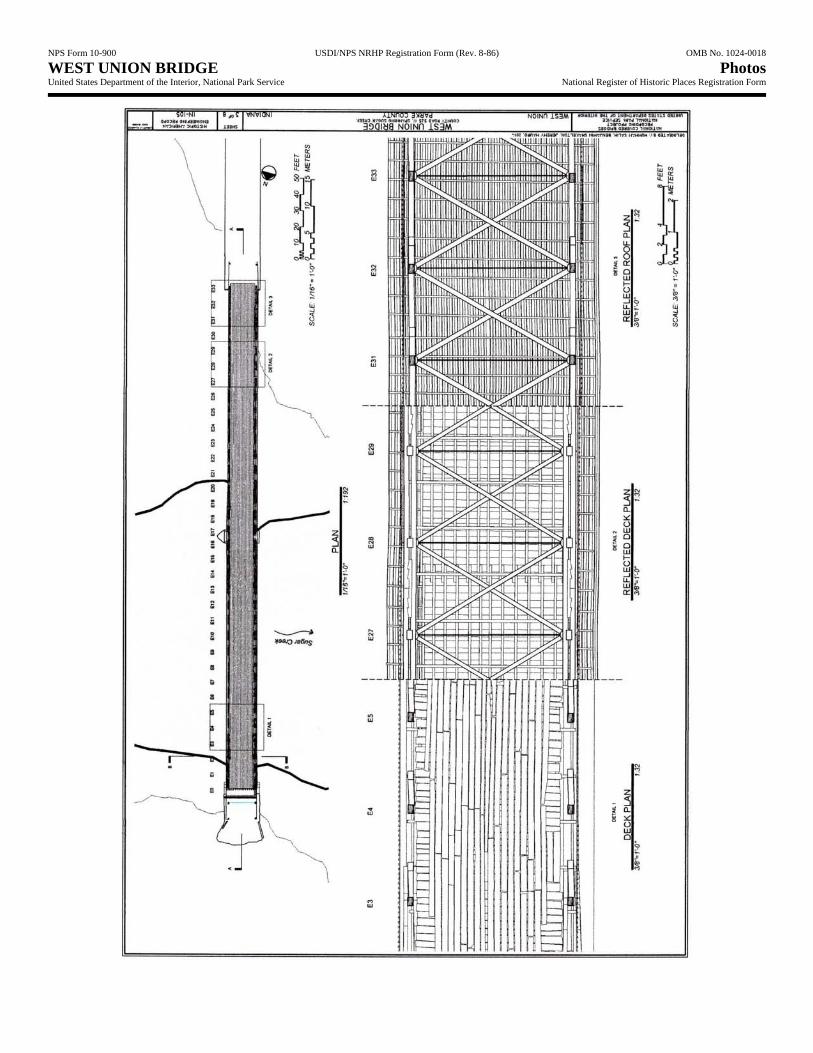
NPS Form 10-900 USDI/NPS NRHP Registration Form (Rev. 8-86) OMB No. 1024-0018 WEST UNION BRIDGE Photos United States Department of the Interior, National Park Service National Register of Historic Places Registration Form

NPS Form 10-900 USDI/NPS NRHP Registration Form (Rev. 8-86) OMB No. 1024-0018 WEST UNION BRIDGE Photos United States Department of the Interior, National Park Service National Register of Historic Places Registration Form

NPS Form 10-900 USDI/NPS NRHP Registration Form (Rev. 8-86) OMB No. 1024-0018 WEST UNION BRIDGE Photos United States Department of the Interior, National Park Service National Register of Historic Places Registration Form

NPS Form 10-900 USDI/NPS NRHP Registration Form (Rev. 8-86) OMB No. 1024-0018 WEST UNION BRIDGE Photos United States Department of the Interior, National Park Service National Register of Historic Places Registration Form

NPS Form 10-900 USDI/NPS NRHP Registration Form (Rev. 8-86) OMB No. 1024-0018 WEST UNION BRIDGE Photos United States Department of the Interior, National Park Service National Register of Historic Places Registration Form

NPS Form 10-900 USDI/NPS NRHP Registration Form (Rev. 8-86) OMB No. 1024-0018 WEST UNION BRIDGE Photos United States Department of the Interior, National Park Service National Register of Historic Places Registration Form

NPS Form 10-900 USDI/NPS NRHP Registration Form (Rev. 8-86) OMB No. 1024-0018 WEST UNION BRIDGE Photos United States Department of the Interior, National Park Service National Register of Historic Places Registration Form
WEST UNION BRIDGE. General view from northwest. Photograph by James Rosenthal, 2004 [HAER No. IN-105-1].
WEST UNION BRIDGE. General view from south. Photograph by James Rosenthal, 2004 [HAER No. IN-105-2].

NPS Form 10-900 USDI/NPS NRHP Registration Form (Rev. 8-86) OMB No. 1024-0018 WEST UNION BRIDGE Photos United States Department of the Interior, National Park Service National Register of Historic Places Registration Form
WEST UNION BRIDGE. South portal elevation. Photograph by James Rosenthal, 2004 [HAER No. IN-105-4].
WEST UNION BRIDGE. View of 1914 concrete approach. Photograph by James Rosenthal, 2004 [HAER No. IN-105-6].

NPS Form 10-900 USDI/NPS NRHP Registration Form (Rev. 8-86) OMB No. 1024-0018 WEST UNION BRIDGE Photos United States Department of the Interior, National Park Service National Register of Historic Places Registration Form
WEST UNION BRIDGE. Elevation of south abutment. Photograph by James Rosenthal, 2004 [HAER No. IN-105-9].
WEST UNION BRIDGE. View of floor system from south. Photograph by James Rosenthal, 2004 [HAER No. IN-105-12].

NPS Form 10-900 USDI/NPS NRHP Registration Form (Rev. 8-86) OMB No. 1024-0018 WEST UNION BRIDGE Photos United States Department of the Interior, National Park Service National Register of Historic Places Registration Form
WEST UNION BRIDGE. General view of interior from north. Photograph by James Rosenthal, 2004 [HAER No. IN-105-13].
WEST UNION BRIDGE. Oblique view of arch from north. Photograph by James Rosenthal, 2004 [HAER No. IN-105-15].

NPS Form 10-900 USDI/NPS NRHP Registration Form (Rev. 8-86) OMB No. 1024-0018 WEST UNION BRIDGE Photos United States Department of the Interior, National Park Service National Register of Historic Places Registration Form
WEST UNION BRIDGE. Perspective view looking northeast. Photograph by Lola Bennett, 2015.
WEST UNION BRIDGE. Perspective view looking southeast. Photograph by Lola Bennett, 2015.

NPS Form 10-900 USDI/NPS NRHP Registration Form (Rev. 8-86) OMB No. 1024-0018 WEST UNION BRIDGE Photos United States Department of the Interior, National Park Service National Register of Historic Places Registration Form
WEST UNION BRIDGE. Interior view looking toward south portal. Photograph by Lola Bennett, 2015.
WEST UNION BRIDGE. Detail of arch-truss connection. Photograph by Lola Bennett, 2015.

NPS Form 10-900 USDI/NPS NRHP Registration Form (Rev. 8-86) OMB No. 1024-0018 WEST UNION BRIDGE Photos United States Department of the Interior, National Park Service National Register of Historic Places Registration Form
Detail of A.T. Andreas’ Atlas Map of Parke County, Indiana (1874), showing bridge location. Source: Ball State University Digital Media Repository.

NPS Form 10-900 USDI/NPS NRHP Registration Form (Rev. 8-86) OMB No. 1024-0018 WEST UNION BRIDGE Photos United States Department of the Interior, National Park Service National Register of Historic Places Registration Form
Topographic map detail, showing West Union Bridge location. UTM Reference: 16.471232E.4411699N, WGS84 geodetic datum.
Montezuma, Indiana, USGS Quad., 7.5-minute series/1:24,000 scale, 2013. Source: United States Geological Survey, U.S. Department of the Interior.