1 metpetdb: a database for metamorphic geochemistry 3
TRANSCRIPT
1
MetPetDB: A database for metamorphic geochemistry 1 (v. 04 Dec 2007) 2
3 Frank S. Spear, Joseph M. Pyle 4
Department of Earth and Environmental Sciences 5 6
Sibel Adali, Boleslaw K. Szymanski, Anthony Waters, Zak Linder, Cagri Ozcalar, Shawn O. 7 Pearce, 8
Department of Computer Sciences 9 10
Rensselaer Polytechnic Institute 11 Troy, NY, 12180, USA 12
13 Abstract 14 15 We present a data model for the initial implementation of MetPetDB - a geochemical 16
database specific to metamorphic rock samples. The database is designed around the concept of 17
preservation of spatial relationships, at all scales, of chemical analyses and their textural setting. 18
Virtual objects in the database (samples) represent physical rock samples; each sample contains 19
one or more subsamples with associated geochemical and image data. Samples, subsamples 20
geochemical data and images are described with attributes (some required, some optional); these 21
attributes also serve as search delimiters. All data in the database are classified as public (i.e. 22
archived or published data) or private. Public data may be freely searched and downloaded. All 23
private data is owned; permission to view, edit, download and otherwise manipulate private may 24
be granted only by the data owner; all such editing operations are recorded by the database to 25
create a data version log. The sharing of data permissions among a group of collaborators 26
researching a common sample is done by the sample owner through the project manager. User 27
interaction with MetPetDB is hosted by a web-based platform based upon the Java servlet 28
application programming interface, with the PostgreSQL relational database. The database web 29
portal includes modules that allow the user to interact with the database: guest users may search, 30
view public data and registered users may save and download public data, upload private data, 31

2
create projects, and assign permission levels to project collaborators. An Image Viewer module 32
is available within the web portal for spatial integration of image and geochemical data. A toolkit 33
consisting of plotting and geochemical calculation software will be available for data analysis. 34
Future issues to address include population of the database, integration with other geochemical 35
databases, development of the analysis toolkit, creation of data models for derivative data, and 36
building a community-wide user base. It is believed that this and other geochemical databases 37
will enable more productive collaborations, generate more efficient research efforts, and foster 38
new developments in basic research in the field of solid earth geochemistry. 39
40 41

3
41 Introduction 42
Current research in the geological sciences generates a huge amount of visual and 43
numeric data, and the recognition of the need to catalog and share this data (e.g., see white 44
papers at www.communitytechnology.org/nsf_ci_report, 45
www.adec.edu/nsf/nsfcyberinfrastructure.html, 46
www.nsf.gov/news/special_reports/cyber/index.jsp) as a value-added research tool has spurred 47
the development of a number of organizations (EARTHCHEM 48
http://www.earthchem.org/earthchemWeb/index.jsp; GEON - Geosciences Earth network - 49
http://www.geongrid.org/; SESAR http://www.geosamples.org/) and databases (GEOROC 50
http://georoc.mpch-mainz.gwdg.de/georoc/Start.asp; NAVDAT http://navdat.kgs.ku.edu/; and 51
PETDB http://www.petdb.org/petdbWeb/index.jsp) specific to handling, sharing, and 52
manipulating data generated in the research and analysis of earth materials. 53
A compelling justification for this development is the belief that fundamentally new science will 54
emerge from the scientific disciplines that possess highly evolved cyberinfrastructure. A leading 55
example in the geosciences is the use of ocean basalt chemistry data mined from PETDB 56
(Lehnert et al., 2000); GeoRef searches utilizing "PetDB" as a delimiting term return hits on 57
several papers published in the last three years (Spiegelman and Kelemen, 2003; Salters and 58
Stracke, 2004; Hirschmann et al., 2003). These papers make use of large data sets that would 59
have been virtually impossible for an individual, or small group of collaborators, to collate until 60
the advent of the aforementioned databases. 61
Although some metamorphic rocks are included in existing petrologic databases, and at 62
least one database has been developed specifically to address some of the needs of metamorphic 63
petrology (Schmatz et al., 1995), there is no current global database that incorporates the special 64

4
requirements of metamorphic geochemistry. Interpretations of metamorphic parageneses require 65
not only high precision chemical analyses of minerals present, but evaluation of the textural 66
context of those analyses. Because of this, a large component of the existing metamorphic data is 67
images (photomicrographs, back-scattered, secondary electron (BSE and SE) and 68
cathodoluminescence (CL) images, X-ray maps, etc.) and the location of analyses with respect to 69
these images is a critical component of a metamorphic database. Unfortunately, many of the 70
images and analyses collected during the course of a study never get published owing to 71
limitations of print media. Indeed, it is estimated by the authors that less than one percent of all 72
data collected on metamorphic rocks is published, which suggests that a potential treasure trove 73
of information is waiting to be mined, given the proper infrastructure. 74
The preservation of spatial relationships at a variety of scales thus differentiates a 75
geochemical database for metamorphic rocks from other geochemical databases, and provides a 76
framework for its design. In our realization, the basic components of a database specific to 77
metamorphic petrology should (1) include the incorporation of bulk rock and mineral analyses; 78
(2) provide for the incorporation of images of any type; (3) preserve the spatial relationship 79
among the various images collected on a thin section; (4) preserve the relationship between 80
analyses and textural setting of the analyses on the relevant images; (5) provide an intuitive user 81
interface that allows for searching, uploading, and downloading sample information as well as 82
facilitating collaborations among researchers; (6) provide a set of tools for recalculation, plotting, 83
and analysis of data; and (7) interface with other geological databases. We envision a database 84
that is populated not only with published, archive data, but incorporates unpublished data that 85
complements what is published, and that can also serve as a research level collaborative tool for 86
researchers globally. 87

5
Ideally, a metamorphic database should incorporate both raw data (analyses, images, etc., 88
collected on a sample) as well as derivative or interpretative data for an area (P-T conditions, P-89
T-t path, cooling history, etc.). The present communication focuses only on the development of 90
the first part of the database for raw data. How to treat derivative/interpretative data is far more 91
complex and will be discussed in a future communication. 92
The Data Model 93
The MetPetDB data model (Fig. 1) is built around the concept of a sample. The sample is 94
a physical entity (a piece of rock) that exists in the database as a virtual entity with associated 95
information, similar to the approach taken by other geochemical databases (e.g., Lehnert et al., 96
2000). A number of considerations have been taken into account in the design of the data model. 97
Typically, a thin section is cut from a sample and analytical work (e.g. electron microprobe 98
analysis) is done on a polished thin section that may be different from the original thin section. 99
Whole rock chemical analyses are done on yet different parts of the rock, and other parts of the 100
sample might be used for mineral separates (e.g. zircons). It is considered imperative that the 101
chain of evidence of these distinct pieces of a sample be kept intact, so we have also introduced 102
the concept of a subsample, which is, as the name implies, a piece of the original sample. 103
Chemical analyses are always done on subsamples (unless the entire sample has been crushed for 104
analysis). Each thin section is a subsample and a piece of the rock used for mineral separates is 105
yet another subsample. Images may be associated with the sample or an individual subsample 106
(e.g. thin section). It is also possible that an image is associated with more than one sample (e.g. 107
a photograph of an outcrop), which we have called a supersample image. Each of these data 108
types has its own set of attributes, which will be discussed in this section. 109

6
Sample 110
Sample attributes are shown in Table 1 with required attributes labeled "R". The 111
minimum required information for adding a sample to the database are (1) sample number; (2) 112
location (latitude and longitude); (3) rock type (see Table 2); and (4) sample owner, although, of 113
course, additional information is highly desirable. When available, the ISGN (International Geo 114
Sample Number) can provide the unique sample identifier and in the future we expect that all 115
samples will be registered and have ISGNs. Latitude and longitude provide location, with the 116
option to provide a location error if a sample is not well located. Although modern topographic 117
maps and GPS provides location within a few meters, many older data are not so precisely 118
located, and it is deemed important that the location of a sample is not misrepresented. The rock 119
types shown in Table 2 is restrictive relative to the total range of metamorphic rock names that 120
have been used in the literature. However, it was decided that a compact, simple list would be 121
preferable to a comprehensive list because it would help avoid the use of ambiguous names. It is 122
fully recognized that many researchers will wish to use their own favorite (in some cases locally 123
derived) rock names, and this is encouraged. MetPetDB will accommodate as many of these as 124
desired in comment fields. Next, if the data is from a published article (i.e., archived data) a 125
unique reference to the publication is required. We have followed the approach of NAVDAT in 126
adopting the 10-digit GeoRef Accession Number as the unique publication identifier. 127
Furthermore, every sample must have an owner so that data use permissions can be properly 128
evaluated. It is recognized that this will create some special issues in the long-term (e.g. the 129
decease of a data owner), which will be dealt with as individual cases. Finally, published data 130
will be labeled "public" and will not be editable (to preserve the published record) whereas 131
unpublished data will be labeled "private" and will be editable by the owner. 132

7
Optional data include the country of origin (recognizing that the country may no longer 133
exist), and the "region" from which the sample was collected. Multiple regions are allowed 134
because it is recognized that petrologists will wish to locate samples using multiple geographic 135
names. For example, a sample from the first author's collection comes from the "Eastern Alps", 136
the "Tauern Window", the "Hohe Tauern" the "Großvenediger region", the "Froznitztal", and the 137
"Tauern Eclogite Zone". Multiple regions might make searching more difficult initially, but it is 138
planned to develop absolute geographic outlines for specific regions based on the database 139
population that will facilitate searching. 140
A list of minerals and modes is optional data because it was discovered that not all 141
published papers provide a list of minerals. Furthermore, it is specifically not required to list a 142
mineral assemblage, because the term "assemblage" carries the implication of a stable 143
equilibrium assemblage at some metamorphic conditions, and that is most definitely an 144
interpretation. Additionally, the metamorphic facies (or grade) attribute (Table 3) can be multi-145
valued, due to the recognition that, for the same suite of rocks, one author may use the term 146
"amphibolite facies" whereas another author may select "staurolite zone" as the descriptor of 147
metamorphic grade. This will not complicate searches because it will be simple to choose both 148
search criteria. Items such as collector and collection date are self-explanatory. The attribute 149
"present sample location" is included so that individuals who wish to use a sample can find it. 150
Note that it is not necessary for chemical analyses to be available for a sample to be 151
entered into the database. In this way, MetPetDB differs from other geochemical databases (e.g. 152
PetDB, NAVDAT, and GeoRoc) in that it is, fundamentally, a database of metamorphic samples. 153
This does not limit in any way the usefulness of MetPetDB and it provides the opportunity of 154
8
recording the types of rocks found in a metamorphic terrane even when only a sample has been 155
taken from the field. 156
Subsample 157
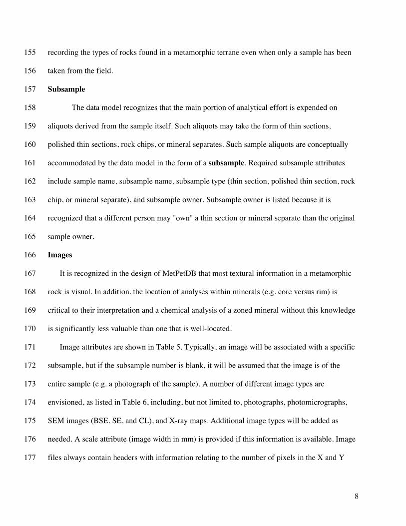
The data model recognizes that the main portion of analytical effort is expended on 158
aliquots derived from the sample itself. Such aliquots may take the form of thin sections, 159
polished thin sections, rock chips, or mineral separates. Such sample aliquots are conceptually 160
accommodated by the data model in the form of a subsample. Required subsample attributes 161
include sample name, subsample name, subsample type (thin section, polished thin section, rock 162
chip, or mineral separate), and subsample owner. Subsample owner is listed because it is 163
recognized that a different person may "own" a thin section or mineral separate than the original 164
sample owner. 165
Images 166
It is recognized in the design of MetPetDB that most textural information in a metamorphic 167
rock is visual. In addition, the location of analyses within minerals (e.g. core versus rim) is 168
critical to their interpretation and a chemical analysis of a zoned mineral without this knowledge 169
is significantly less valuable than one that is well-located. 170
Image attributes are shown in Table 5. Typically, an image will be associated with a specific 171
subsample, but if the subsample number is blank, it will be assumed that the image is of the 172
entire sample (e.g. a photograph of the sample). A number of different image types are 173
envisioned, as listed in Table 6, including, but not limited to, photographs, photomicrographs, 174
SEM images (BSE, SE, and CL), and X-ray maps. Additional image types will be added as 175
needed. A scale attribute (image width in mm) is provided if this information is available. Image 176
files always contain headers with information relating to the number of pixels in the X and Y 177

9
dimensions, and this information can be extracted from the file. The image resolution (size of an 178
individual pixel) can thus be calculated if the full width dimension is provided. 179
A key aspect of preserving the usefulness of metamorphic data is preservation of the 180
spatial relationship among minerals. For example, is a particular muscovite crystal located in the 181
shear plane or the Q-F domain of a crenulation cleavage? Is a particular monazite located in the 182
core or near the rim of the garnet host? In other words, the spatial relationship of minerals with 183
respect to each other (i.e. the texture) is critical for the interpretation of the chemistry of these 184
phases. To preserve these relationships, MetPetDB will incorporate a subsample grid system 185
whereby all images and analyses will be located with respect to a coordinate system for the 186
individual subsample. It is perhaps simplest to think of this as a GIS (Geographic Information 187
System) for thin sections where the data include images and analyses. The system will include an 188
image viewer that will permit the user to register images with respect to one another and to 189
locate and view analyses with respect to these images. Examples of the image viewer will be 190
given below in the section on user interface. 191
Some images include more than a single sample as, for example, a photograph of an 192
outcrop or a scanned image of a map on which sample locations are marked. These types of 193
images are designated as supersample images. Required attributes for the supersample image 194
(Table 7) include image file name, image type (map or photograph), and sample number (1-n). 195
Optional X-Y coordinates for the sample on the image are provided so that sample positions can 196
be linked directly to supersample images (e.g. a map or outcrop photograph). 197
Chemical analyses 198
Chemical analyses form the core of any geochemical database although, as noted above, 199
it is not a requirement that chemical analyses exist for a sample to be entered into MetPetDB. 200

10
Required attributes for chemical analyses include (Table 8) (in addition to information about the 201
sample and subsample): (1) mineral name (either identity of mineral or "bulk" for a whole-rock 202
analysis); (2) analytical method; (3) element or species name; (4) units of concentration (e.g. 203
weight percent oxide, ppm, etc.); (5) concentration value; (6) analysis owner. Optional attributes 204
provide information about the analytical facility, analysis date and analyst, publication reference, 205
and supporting analysis information (e.g., spot number, element precision, analysis total). 206
Two different types of data attributes are included to provide spatial information about an 207
analysis. The "reference image name" refers to an image on which the analysis is located. In 208
some cases this may be a scanned image (e.g. photograph or BSE image) with analysis spots 209
located by hand. If the location of the analysis spot on this reference image is known, then the 210
coordinates can be specified. Finally, it is common on many electron microprobes that the X-Y 211
stage coordinates are saved with the analysis data. The reference frame for these coordinates 212
change every time a sample is reloaded into the microprobe, but for a single session they can 213
provide useful spatial information. For example, the X-Y stage coordinates for points taken on a 214
line traverse provide information about the distance between analyses. 215
It is noted here the analytical method attribute could be expanded significantly to 216
encompass a series of method-specific sub-attributes and metadata; this topic has been discussed 217
at length (e.g., “Data Reporting in Geochemistry”, an EarthChem workshop held at Lamont-218
Doherty Earth Observatory in April, 2007). For example, the analytical method attribute = 219
Electron Microprobe (EMP) generates a whole suite of subsidiary attributes relating to machine 220
settings (e.g., diffraction crystal, calibration standard, detector gas), analytical conditions 221
(accelerating voltage, analysis current, analysis time), and post-analysis processing (background 222

11
fitting, ZAF correction routine). Instrument-specific analytical attributes are, at present, beyond 223
the scope of this data model, but will be incorporated in future versions. 224
Data Ownership and Sharing 225
MetPetDB is being designed to fill three major functions: It is intended to be a repository 226
of published data on metamorphic rocks (sample information, chemical analyses, etc.), it is 227
intended to store supplemental, supportive data that compliments published data but is too 228
voluminous to be published by traditional means, and it is intended to be a platform to facilitate 229
the collaboration of research projects among geoscientists around the globe. This section 230
discusses aspects of data permissions and sharing that will be implemented in MetPetDB. 231
Data Types and Data Ownership 232
All data housed in MetPetDB will tagged with an owner. Data that are published will be 233
tagged as "public" ownership, which will allow any user to view it. Public data is immutable; its 234
content in the database should be a mirror image of the original data in the publication, and, 235
except under special circumstances, by a system administrator, cannot be added to or edited in 236
any way, with the exception of addition of comments. 237
All other data will be considered "private" and will have a designated owner, which is 238
typically the individual who collects and uploads the data. Private data will have restricted access 239
unless the owner decides to make the data "public", in which case it will have the same access 240
privileges as other public data. Sharing of data with collaborators will be coordinated through the 241
project manager (see below). 242
Ownership of data will be prescribed at the levels of sample, subsample, images, and 243
analyses (see Tables 1, 4, 5, 7, and 8). This level of ownership demarcation was considered 244
necessary because it is easily envisioned that individual A might be the owner (collector) of a 245

12
sample, whereas individual B is the owner of a thin section from that sample. Individual B might 246
have done a considerable amount of work on this thin section, including publishing a subset of 247
the data (images and analyses) collected. Permitting ownership at the level of subsamples, 248
images, and analyses covers the common situation where only a subset of the data collected on a 249
sample are published (and therefore "public" by default) but the data owner might wish to keep a 250
large amount of unpublished data private. 251
Scientific Collaboration – the “Project Manager” 252
A major goal of MetPetDB is to facilitate research collaborations between individuals 253
and research groups anywhere on the planet; such collaborations are likely to involve new and 254
unpublished data that collaborators wish to share with each other, but not yet the general public. 255
This sharing of data, from one or more samples grouped under a collective research effort 256
between individuals or groups, will be handled through the project manager. Collections of 257
samples that pertain to a specific research effort will be called "projects". Projects will have a 258
project chief plus participants, with the chief having responsibility for overseeing the 259
organization of the effort. For example, the project chief will have responsibility for adding (or 260
removing) participants from the project. Projects can contain both public and private data with 261
read/write permissions being granted to project participants by the data owners and handled 262
through the project manager. Data and individuals can belong to multiple projects, but each 263
project can have only one project chief. 264
Database Implementation and Hardware 265
MetPetDB's implementation is based upon the Java servlet application programming 266
interface (API); this choice gives us immediate access to the extensive library of open source 267
Java software. In particular, we are interested in leveraging many of the web applications and 268

13
geographic information systems frameworks that are typically available for the Java platform. 269
PostgreSQL was chosen as the relational database due to its strong adherence to the SQL 270
standards, and its relative ease of administration. The PostGIS extensions to PostgreSQL 271
provided a compelling platform for our GIS needs. 272
Object metadata for samples, subsamples, images and chemical analyses are stored 273
directly in a PostgreSQL database using a properly normalized relational schema. Most metadata 274
constraints such as required values and valid value ranges are expressed and enforced by the 275
database, with the MetPetDB application automatically mining the constraints out of the 276
database and implementing the same logic within the Java application. This arrangement allows 277
the database to provide complete enforcement of constraints, but also allows the application 278
interface to offer immediate targeted feedback to the user when incorrect data is supplied. 279
We expect a fairly large collection of images in the system. Accordingly, image files are not 280
stored within PostgeSQL due to the difficulties associated with backing up and restoring multi-281
gigabyte tablespaces (data files used by the database). Instead, the image files are stored in the 282
UNIX filesystem in separate directories. The location of the file is determined by taking the file 283
content and hashing it to filename using the SHA-1 algorithm. As SHA-1 provides a fairly 284
uniform distribution over filenames, disk arrays can be divided into 256 partitions, using the first 285
byte of the SHA-1 hash to automatically determine the partition that will hold the image file. On 286
a 5 terabyte disk array each partition would be only 20 gigabytes. Backing up and restoring 20 287
gigabytes is a fairly simple process to manage. 288
Extensive use of AJAX (Asynchronous JavaScript and XML) through the Google Web 289
Toolkit, (GWT) allows the end user's web browser to efficiently request only the raw data 290
required to update each page instead of reloading the current page after a request. After simple 291

14
gzip compression has been applied, the size of the transmitted data packet will average well 292
under 1 kilobyte, facilitating easy server retrieval of the relevant object metadata and transfer to 293
the client at wire speed. As the bulk of most per-page processing costs is generally the HTML 294
production (and not the database query processing), pushing this load onto the client browsers 295
reduces the server side costs, making the entire MetPetDB application more responsive to all 296
users. 297
To ensure high-availability, fault tolerance, and adequate storage for images, we will 298
house the system initially on multiple high-end database servers with adequate storage space 299
(two QSQL Q524 5U 5Tb servers). The two servers will contain identical copies of the database 300
at all times; user requests may then be answered from either server. This will improve system 301
response time, enable large file transfers at a moderate time cost, and provide a back-up system 302
in case of temporary failure of one of the servers. We plan to eventually store the servers in 303
different locations to minimize the downtime caused by power outages and surges. A third 10Tb 304
server will keep incremental updates of the two primary 5Tb servers for up to 30 days. All 305
machines are currently housed in the Computer Science Department Laboratory at Rensselaer. 306
An existing 300Gb server is currently being used as the development platform. 307
The User Experience 308
MetPetDB will be accessed through a web portal. The database home page (Fig. 2) has 309
options for (1) login or registering; (2) viewing samples; (3) managing projects; and (4) 310
searching the database. A user wishing to explore a suite of samples will see the requested 311
information displayed in a number of different pages. The list of selected samples (these may be 312
part of a project, a suite found from searching, or a user's entire sample collection) are displayed 313
on the sample list page, a page that shows, in addition to the sample number, a list of other 314

15
sample attributes (Fig. 3). For each page a default set of attributes will be displayed, and these 315
will be fully configurable by each individual user. Selecting a sample brings up the sample page 316
(Fig. 4), which displays general characteristics of a sample, as well as a sample image and a list 317
of the subsamples. Selecting a subsample brings up the subsample page with configurable 318
attributes about available images and analyses displayed (Fig. 5). 319
Chemical analyses may be of a mineral or the bulk rock. A list of the minerals for which 320
analyses are available is provided and the user can choose to view the entire set of analyses for a 321
particular mineral (Fig. 6), or to download the analyses to a spreadsheet format. Note that one 322
attribute for chemical analyses is the reference image, which is the image on which the spot 323
chemical analysis is located, and analysis locations can be viewed on these images as well. 324
Images for a subsample can be viewed in two different ways. The image list page 325
provides details about every image available for a subsample, which can be viewed in either list 326
format or as thumbnails (Fig. 7). Individual images can be examined in pop-up windows. 327
Alternatively, all images can be displayed on the image viewer (Figure 8). The image 328
viewer is a module designed to display any or all of the images in a subsample in their correct 329
spatial positions with respect to each other. The image viewer incorporates the concept of a 330
subsample map (or image grid) onto which images can be placed. Each image can be scaled and 331
rotated in order to locate them in their proper positions. Transparency can be adjusted to aid in 332
registration and the entire image map can be viewed at a wide range of scales. The purpose of 333
developing the image viewer is to preserve the textural setting of all data, which is an essential 334
part of the interpretative process. 335
Figure 8 shows an example of an image map from a sub-sample (thin section) from 336
sample V6B, a garnet-biotite-sillimanite migmatite from the Valhalla Complex, British 337

16
Columbia (Spear and Parrish, 1996). At wide zoom, one BSE image and three photomicrographs 338
are located and scaled with respect to the thin section image (Fig. 8a). Figure 8b shows an 339
enlargement of a part of the thin section image with a Ca X-Ray map overlay. Analysis spots are 340
shown in their proper location on the sample in Figure 8c. In fully annotated samples, the 341
analysis spots will be linked directly to the analyses in the database. 342
Searching the database 343
MetPetDB will be searchable by nearly all of the data attributes including words found in 344
comment fields. Searchable items include (but are not limited to) rock type, minerals present, 345
metamorphic grade, latitude and longitude, region name, collector, publication, availability of 346
images (e.g. Ca X-ray map), availability of analyses (e.g. samples with scapolite analyses), and 347
composition range of analyses (e.g. 2.5 < MgO < 7.5). 348
Mineral-delimited searches will be hierarchical using a mineral classification tree. This 349
approach will ensure that selecting "chain silicate" will search on all pyroxenes and amphiboles 350
but that selecting "glaucophane" will find only those samples in which glaucophane has been 351
listed. Users will be able to refine searches so that only the desired information is returned. Once 352
a search is completed, results will be viewable by any of the viewing pages described above, or 353
plotted on a map view such as Google Maps or Google Earth. 354
Managing Projects 355
The web portal will allow sample owners to create and manage projects. Managing a project 356
includes selecting samples to be included in the project and collaborators to be a part of the 357
project. 358
Evolution of and future directions for MPDB 359

17
The future of MetPetDB (or any other geological database) depends on its usefulness to 360
the geologic community. We believe that a well-designed and comprehensive database for 361
metamorphic geochemistry will be compelling to the geologic community, but a number of 362
significant issues need to be addressed before this becomes a reality. In particular, the database 363
must be populated with sufficient high quality data and searches return useful information. 364
Second, there must be significant value added to compel individuals to put forth the effort that 365
will be required to help populate the database. Third, there needs to be seamless integration with 366
other databases so that individuals can find the information they seek without concern for where 367
those data reside. Finally, there need to be demonstrated scientific problems that can only be 368
solved by large collections of data and advanced search algorithms. 369
Populating the database 370
MetPetDB will only be as useful as the quantity and quality of data it contains. As 371
mentioned earlier, it is estimated that less than one percent of metamorphic data are published, 372
and the question must be addressed how the other >99% of data will be incorporated into the 373
database. 374
In general, data will be added to MetPetDB in two ways. Individual samples can be 375
added to the database via web pages designed for that purpose. Bulk uploading of sample and 376
image attributes, images, and chemical analyses will also be implemented. It is anticipated that 377
users will upload their own data, and it remains to be seen whether the large volume of data that 378
currently resides on individual computers hard drives and in file cabinets will eventually be 379
accessible to everyone. It is our hope that over time these data will find their way into the 380
database as researchers and students find it desirable to do so. For example, an excellent place 381
for a student to start a project in a new area is to become aware of all previous work that has 382

18
been done in the region. If information on a region resides in the student's advisors file cabinets, 383
this becomes an excellent opportunity to further populate the database. Once the backlog of 384
existing data is uploaded, populating the database with newly collected data should become 385
routine. Eventually, it is anticipated that direct uploading from analytical instruments (e.g. 386
electron microprobes) may be possible so that users will need to expend only a minor amount of 387
effort. 388
Published data will be digitized and incorporated into the database by the database 389
working group during the initial project phase. This effort has already begun and, as of this 390
writing, we have mined approximately 120 articles, dating between 1962-2005. Journals 391
currently represented include American Journal of Science, The American Mineralogist, 392
Contributions to Mineralogy and Petrology, Journal of Petrology, and Journal of Metamorphic 393
Geology. Although the initial effort to add the wealth of published information will be large, it is 394
hoped that at some point publication in an established journal will include addition of the 395
relevant data to the database, thus ensuring the database is up to date with the most current 396
published works. 397
MetPetDB user toolkit 398
A compelling reason to upload one's own data into MetPetDB, in addition to facilitating 399
collaborations with colleagues, will be the ability to make use of the extensive toolkit that will be 400
developed. It is planned to develop codes to do common tasks such as composition plotting and 401
mineral formula recalculations, including ones requiring stoichiometric constraints to estimate 402
ferric iron content (e.g. pyroxenes and amphiboles). The toolkit will contain a complete set of 403
published thermobarometry routines (e.g. Spear et al., 1991) that can be used on any database 404
analyses and it is planned to provide links to facilitate approaches such as the "average P-T 405

19
calculation" approach (e.g. Powell and Holland, 1994; Berman, 1991). Additional analysis tools 406
will include software for age calculations (from U, Th, Pb) measurements, pseudosection 407
construction, and contour plotting of P-T diagrams. 408
Future plans for MetPetDB include the incorporation of derivative or interpretative data. 409
These terms refer to the fact that some very useful information about metamorphic rocks is only 410
obtained after significant recalculation, analysis, and interpretation of the basic composition and 411
image data. Information such as P-T conditions, maximum temperature or pressure, the P-T path, 412
the age of chemical domains of monazite, or the timing of crenulation development all fit the 413
category of requiring significant interpretation of raw data. Such information is in a very real 414
sense the desired result of many metamorphic studies, and would be of great use to researchers in 415
a wide range of fields outside of metamorphic petrology. We do not yet have a satisfactory data 416
model for these types of information, but it is planned to incorporate such derivative data into 417
MetPetDB in the future. 418
Integration with other databases 419
Researchers searching for information are not concerned with where the retrieved 420
information is stored, but they are concerned that they find all of the information relevant to their 421
study. MetPetDB will be integrated with other databases of the EarthChem consortium 422
(www.EarthChem.org), which includes PetDB, NAVDAT, and GeoRoc. Eventually, as other 423
databases come on line, these will be integrated as well. 424
New Directions 425
We envision that MetPetDB will be useful for museum curators, university, and 426
secondary school teachers. A significant potential for exploring the geologic world will exist 427
through databases such as MetPetDB and it is our intention to include materials on the web 428

20
portal that will assist guest users who may not be versed in geochemistry to find useful and 429
interesting information. 430
The potential also exists for MetPetDB to alter basic research methodologies within the 431
metamorphic petrology community. Hypothesis testing will be possible, in many cases, without 432
the time and financial expense required to plan and execute field work, collect, process, and 433
analyze samples. If the quality of the data in the database is maintained at a high level, the 434
researcher essentially enters the project at the interpretation stage, which could, in many cases, 435
dramatically lower the time and cost of research and allow significant new directions to be 436
explored. 437
Additionally, future data mining algorithms may allow researchers to explore aspects of 438
the global geochemistry that are currently impossible. For example, consider a hypothesis that a 439
particular type of Ca zoning in garnet signifies a particular type of tectonic evolution. There 440
might be several dozen Ca zoning maps of garnet in the entire metamorphic literature today, but 441
there might be many thousands in a well-populated database. Examining these by hand would be 442
prohibitive, but future searching might incorporate image recognition algorithms that would 443
permit a query such as "find all of the samples with Ca zoning in garnet that demonstrates a core 444
to rim increase of 20% or more". Sophisticated queries that require large databases are already 445
being demonstrated by users of the igneous geochemistry databases (e.g., Spiegelman and 446
Kelemen, 2003; Salters and Stracke, 2004; Hirschmann et al., 2003) and we anticipate similar 447
applications of MetPetDB. 448
449
450
451

21
452
453
Acknowledgements 454
Members of the Metamorphic Petrology Database working group are thanked for their 455
input and feedback over the course of this project. We would also like to thank Jennifer Rodger, 456
Barbara Firebaugh, Samuel Broadaway, and Julia Cosgrove for archived data extraction and 457
programming error checking routines. John Schumacher is thanked for his design of the MPDB 458
logo. This work is funded by NSF grant EAR-0622345. 459
460
461

22
461
References Cited 462
463
Berman, R.G. (1991), Thermobarometry using multi-equilibrium calculations; a new technique, 464
with petrological applications, Can. Mineral., 29, 833-855. 465
Hirschmann, M.M., Kogiso, T., Baker, M.B., and Stolper, E.M. (2003), Alkalic Magmas 466
generated by partial melting of garnet pyroxenite, Geology, 31, 481-484. 467
Lehnert, K., Su, Y., Langmuir, C.H., Sarbas, B., and Nohl, U. (2000), A global geochemical 468
database structure for rocks, G-cubed, 1(5). 469
Powell, R., and Holland, T. (1994), Optimal geothermometry and geobarometry, Amer. Mineral., 470
79, 120-133. 471
Salters, V.J., and Stracke, A. (2004), Use of the PetDB database for calculating the composition 472
of the MORB-source, Eos Trans. AGU, 85 (47), Fall Meeting Supplement, Abstract SF32A-473
03. 474
Spear, F.S., Peacock, S.M., Kohn, M.J., Florence, F.P., and Menard, T. (1991), Computer 475
programs for petrologic P-T-t path calculations. Amer. Mineral., 76, 2009-2012. 476
Spear, F. S. and R. Parrish (1996), Petrology and petrologic cooling rates of the Valhalla 477
Complex, British Columbia, Can. Jour. Petrol., 37, 733-765. 478
Spiegelman, M., and Kelemen, P.B. (2003), Extreme chemical variability as a consequence of 479
channelized melt transport, G-cubed, 4(7), 1-18. 480
481

23
Figure Captions 481
Figure 1. Schematic of data model for MetPetDB. Boxes highlight data attributes and lines show 482
relationships between objects. 483
Figure 2. Mock-up of MetPetDB home page. Major user operations include managing sample 484
collections, managing projects, and searching the database. 485
Figure 3. Mock-up of web page showing sample listing. Attributes shown in this and other pages 486
are configurable by the user. Major options include sorting the listing, adding or editing 487
sample information, and adding samples to projects. 488
Figure 4. Mock-up of Sample Detail page. 489
Figure 5. Mock-up of Subsample Detail page providing a summary of the information available 490
on the specific subsample. 491
Figure 6. Mock-up of the Analysis Detail page. The information shown on this page can be user-492
configured. Analysis will also be made available for download. 493
Figure 7. Mock-up of Image Detail page for the specified subsample. Enlarged versions of each 494
image can be viewed by clicking on the image. 495
Figure 8. Mock-up of Image Viewer. (A) Full view of a polished thin section. Background image 496
is a thin section scan. Also shown are several photomicrographs and one BSE image. 497
Boxes show location of (B) and (C). (B) Enlargement of part of the Image Viewer 498
showing overlay of a Ca X-ray map. The transparency of each image can be adjusted. (C) 499
Enlargement of a part of the BSE image showing location of analysis spots. Analysis 500
spots for which a reference image and reference image coordinates are specified can be 501
plotted automatically on the grid. 502

Table 1. Sample attributes Sample attribute Required (R) or
optional (O) Number of
possible attributes
Comments
Sample number R 1 IGSN O 1 International Geo Sample
Number Sample alias O 0-n Provides for multiple names for
the same sample Longitude (DD.DDD) R 1 Longitude error (DD.DDD) O 1 Latitude R 1 Latitude error (DD.DDD) O 1 Rock type R 1 Rock names given in Table 2 Region O 0-n Geographic descriptor Country O 0-1 Collector O 0-1 Collection date O 0-1 Present sample location O 0-1 Comment O 0-n Multiple comments possible Reference O 0-n Archived data requires a
reference Metamorphic facies O 0-n Multiple facies allowed Minerals present O 0-n Mineral modes O 0-n Sample owner R 1

Table 2. MetPetDB recognized rock names Slate Phyllite Schist Gneiss Migmatite Anatectite Marble Calc-silicate Greenschist Amphibolite Blueschist Eclogite Granofels Hornfels Skarn Quartzite Jadeitite Glaucophanite Serpentinite Garnetite Pyroxenite Mylonite Cataclasite Metapelite Metaarkose Metagreywacke Metabasite Metacarbonate Metagranite

Table 3. MetPetDB recognized metamorphic grade names Zeolite Prehnite-pumpellyite Greenschist Amphibolite Epidote amphibolite Granulite Blueschist Eclogite Hornfels Chlorite zone Biotite zone Garnet zone Staurolite zone Staurolite-kyanite zone Kyanite zone Sillimanite zone Andalusite zone Sillimanite-K feldspar zone Garnet-cordierite zone Migmatite zone Ultra high pressure Ultra high temperature

Table 4. Subsample attributes
Attribute Required (R) or optional (O)
Number of possible attributes
Comments
Sample number R 1 IGSN, if available Subsample number R 1 e.s. SS01, SS02 etc. Subsample type R 1 Types include thin section, polished
thin section, rock chip, mineral separate
Subsample owner R 1 Subsamples may be owned by individuals different than the sample owner

Table 5. Image attributes Image attribute Required (R) or
optional (O) Number of possible
attributes Comments
Sample number R 1 Subsample number O 0-1 e.g. SS02 or blank if it is a whole sample
image Image file name R 1 Image type R 1 See Table 6 Image scale O 1 Image width in mm Owner R 1 Comments O 0-n Table 6. Image types and attributes Image type Comments Photograph General sample imagery Thin section scan Special image of entire thin section Photomicrograph-Transmitted Plane Polarized Photomicrograph-Transmitted Crossed Polars Photomicrograph-Reflected Plane Polarized Photomicrograph-Reflected Crossed Polars Secondary Electron Image SE Back-Scattered Electron Image BSE Cathodoluminescence Image CL X-ray Element Distribution Map Element name (R)
Element name is required for X-ray maps
Table 7. Supersample image attributes Attribute Required (R)
or optional (O) Number of possible
attributes Comments
Image file name R 1 Image type R 1 Map, photograph Collector O 0-1 Comments O 0-n Description of images, keywords, etc. Sample number Sample location X Sample location Y
R O O
1-n 1 1
Sample to which supersample image refers Location of sample on image
Owner

Table 8. Analysis attributes Attribute Required (R)
or optional (O)
Number of possible attributes
Comments
Sample number R 1 Subsample number R 1 Mineral name R 1 "Bulk" for a whole rock analysis Analytical method R 1 e.g. EMP, LA-ICPMS, SIMS Location of analytical facility O 0-1 Reference O 0-n Published data require a reference Analysis date O 0-1 Analyst O 0-1 Spot number O 0-1 Unique spot number identifier Reference image name O 0-1 Image name or file name on which
analysis spot is located Image X coordinate O 0-1 Location of spot on reference image Image Y coordinate O 0-1 Location of spot on reference image X stage coordinate of analysis O 1 Stage location of spot analysis Y stage coordinate of analysis O 1 Stage location of spot analysis Element or species name Value Units Precision
R R R O
1-n e.g. Si or SiO2
Analysis total O 0-1 Analysis owner R 1 Comment O 0-n

*
*
*
1
* 1*
*
* *
*
1
0..1
*
*
0..1
*
1
*
1*
1
* 1
* 1
*
1
*
1
*
1
*
1
**
**
1
*
1 *
*
*
* 1
1
0..1
0..1
*0..1
*
0..1
*
1* *1
*
1
1*
0..1
*
*1
*1
***
1
*1
1
*
*1
*
1
*
*
sampleNumberIGSNNumberlatitudelatitudeErrorlongitudelongitudeErrorcollectionDatepublicOrPrivatelocationdescriptioncountry
Sample
nameRegion
Collector
username....
User
nameUnknownCollector
nameRockType
nameMetamorphicGrade
...Publication
madeOncomments
CommentnameSubsample
analysisDateanalysisMethodwhereDonemineralspotNumberPositionXPositionYXstageYstagedescriptionanalyticalFacility
ChemicalAnalysis
fileNameheightwidthpixelSizecontrastbrightnesslut
Images nameImageType
nameImageFormat
Collector
weightprecision
DetectedElement
namesymbolatomicNumberweight
Element
topLeftXtopLeftYzorderopacityresizeRatiowidthheight
ImageOnGrid
nameparent_mineral
Minerals
oxidationStatespeciesweightcations_per_oxideconversion_factor
Oxide
nameSubsampleGrid
radiationlinesdwelltimecurrentvoltage
xrayImage
namePrecisionType
weightprecision
DetectedOxide
nameMineralType
amountMineralsPresent
Owner
Owner
Owner
Publication
nameAlias
XY
SuperSample
0..1
*
0..1
*
LEGEND:AttributeName
EntityName
1 *Relationship w/
participation constraints
IS-A relationshipFig 1

Fig 2

Fig 3

Fig 4

Fig 5

Fig 6

Fig 7
