1 location and community composition 1.2 current … · 15-03-2011 · 1 location and community...
TRANSCRIPT
Development Area Profiles: Christiana DA2-1
1 LOCATION AND COMMUNITY COMPOSITION
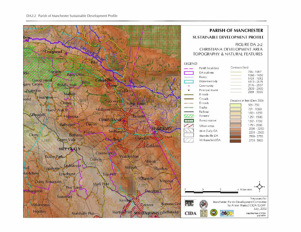
1.1 Location and Extent. The town of Christiana lies some 20 km (12 miles) northeast of Mandeville. The Christiana Development Area covers approximately 14,720 hectares (54.8 square miles) of hilly land (Figure DA2-1 and DA2-2), reaching elevations of over 900 m. It extends to the Clarendon Parish boundary to the east, the Trelawny border to the north and the Mile Gully Development Area to the west.
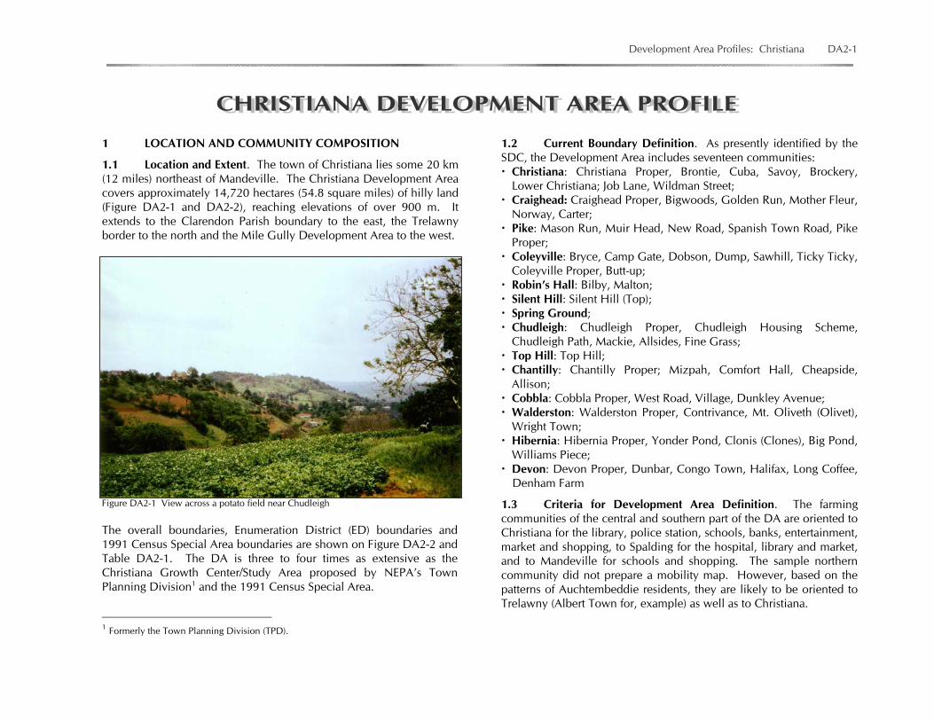
Figure DA2-1 View across a potato field near Chudleigh
The overall boundaries, Enumeration District (ED) boundaries and 1991 Census Special Area boundaries are shown on Figure DA2-2 and Table DA2-1. The DA is three to four times as extensive as the Christiana Growth Center/Study Area proposed by NEPA’s Town Planning Division1 and the 1991 Census Special Area.
1 Formerly the Town Planning Division (TPD).
1.2 Current Boundary Definition. As presently identified by the SDC, the Development Area includes seventeen communities: Christiana: Christiana Proper, Brontie, Cuba, Savoy, Brockery, Lower Christiana; Job Lane, Wildman Street; Craighead: Craighead Proper, Bigwoods, Golden Run, Mother Fleur, Norway, Carter; Pike: Mason Run, Muir Head, New Road, Spanish Town Road, Pike Proper; Coleyville: Bryce, Camp Gate, Dobson, Dump, Sawhill, Ticky Ticky, Coleyville Proper, Butt-up; Robin’s Hall: Bilby, Malton; Silent Hill: Silent Hill (Top); Spring Ground; Chudleigh: Chudleigh Proper, Chudleigh Housing Scheme, Chudleigh Path, Mackie, Allsides, Fine Grass; Top Hill: Top Hill; Chantilly: Chantilly Proper; Mizpah, Comfort Hall, Cheapside, Allison; Cobbla: Cobbla Proper, West Road, Village, Dunkley Avenue; Walderston: Walderston Proper, Contrivance, Mt. Oliveth (Olivet), Wright Town; Hibernia: Hibernia Proper, Yonder Pond, Clonis (Clones), Big Pond, Williams Piece; Devon: Devon Proper, Dunbar, Congo Town, Halifax, Long Coffee,
Denham Farm
1.3 Criteria for Development Area Definition. The farming communities of the central and southern part of the DA are oriented to Christiana for the library, police station, schools, banks, entertainment, market and shopping, to Spalding for the hospital, library and market, and to Mandeville for schools and shopping. The sample northern community did not prepare a mobility map. However, based on the patterns of Auchtembeddie residents, they are likely to be oriented to Trelawny (Albert Town for, example) as well as to Christiana.
DA2-2 Parish of Manchester Sustainable Development Profile

Development Area Profiles: Christiana DA2-3

DA2-4 Parish of Manchester Sustainable Development Profile
Allison residents have said they feel that the district should be part of the Bombay Community in the Williamsfield DA.
1.4 Communities Formerly Included. Changes in community and district names, extent and groupings occur with some frequency in the DA. Box DA2.1 lists former community definitions. 1.5 Suggested Modifications to Boundaries. Allison and areas southeast of Allison (1991 EDs NE70 and NE77) should be reassigned to the Williamsfield DA.
Auchtembeddie should be reconsidered for possible reassignment to Christiana (see Mile Gully DA).
2 SOCIAL CONDITIONS
2.1 Population
2.1.1 Population Growth and Distribution. Christiana is the second most populous town in Manchester after Mandeville, accounting for almost 5% of the parish population. The Christiana urban area recorded a population of 6,437 in 19822 and increased by 12% by 1991 to 7,235. The average annual growth rate of 1.3% was relatively high but lower than the 1.8% rate for Mandeville.
Growth appears to have accelerated over the 1990s and to have exceeded TPD projections (Table DA2.1). The population of the Special Area as defined in 2001 was 8,243, 13.93% more than in 1991.3 Comparison of the boundaries of the special area in the two censuses is needed to determine the actual growth rate.
Table DA2-1 Christiana-Population Projections 1991-2015 Year Male Female Total 1991 3637 3598 7235 1995 3880 3838 7618 2000 4006 4040 8126 2005 4357 4312 8669 2010 4648 4599 9247 2015 4958 4906 9864
Source : Town Planning Department Several communities are included in the growth area. Over the inter-censal period, 1982 to 1991, some communities, Straun Castle (part of Christiana Proper), Clandon, Richmond, Sedburgh and Chudleigh, in the central and southern parts of the DA, experienced population growth of over 40%, a very high rate. Most communities along the Christiana main road showed a negative population growth rate. The TPD analysis prepared in 1996 suggested that these patterns reflected internal migration within the DA.
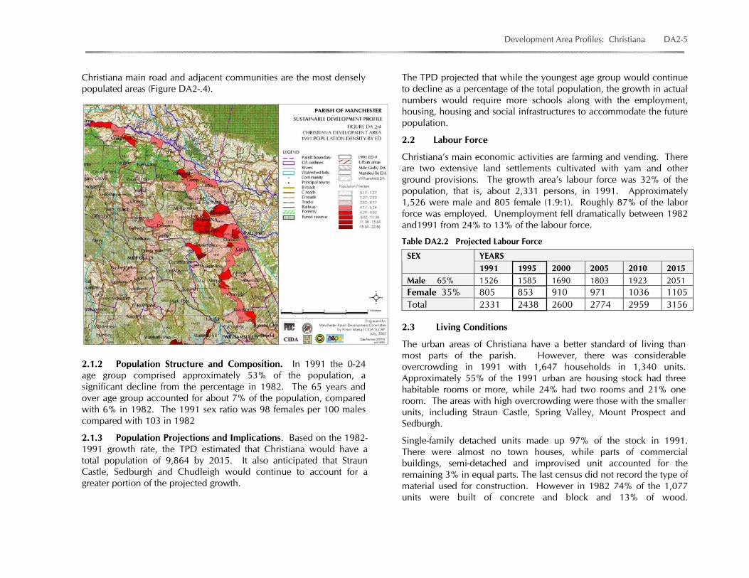
Generally, Christiana is a relatively dense town with approximately 4.32 persons per hectare in 1991. The settlements along the
2 The 1982 Census recorded a population of 8,894 but used an area larger than the 1991 Special Area boundary. 3 STATIN, 2001 Census of Population Preliminary Report, 2000.
BOX DA2.1 CHRISTIANA DA COMMUNITIES AS FORMERLY IDENTIFIED
Communities were formerly identified as follows: Christiana North: Succeed, Lower Christiana, Never Mind; Struan
(Straun) ; Cuba; Brontie; Christiana South: Savoy; Job Lane; Brockery; Wildman St./Mollison; Chudleigh: Allsides; Fine Grass; Mackie; Chudleigh Path; Chudleigh
Housing; Cobbla (Cobbler): Mizpah/Cheapside; Dunkley’s Avenue; Mount Olivet;
Allison (bottom); West Road; Village; Coleyville: Ticky Ticky; Dump; Camp Gate; Sawmill; Dobson; Bryce; Craig Head: Golden Run; Bigwoods; Carter; Norway; Mother Fleur;
Devon: Dunbar; Long Coffee; Big Pond; Halifax; Congo Town; Pike: New Road; Spanish Town Road; Mason Run; Muir Head; Robins Hall: Malton; Silent Hill: Top Silent Hill; Bottom Silent Hill; Spaulding Hill: Clondon; Spring Ground: Richmond, Kyle, Bamboo, Lower Spring Ground,
Clandon, George North; Top Hill: Contrivance, Wright Town; Walderston: Thompson Piece, Junction, Albion Gully.
Source: SDC
Development Area Profiles: Christiana DA2-5
Christiana main road and adjacent communities are the most densely populated areas (Figure DA2-.4).
2.1.2 Population Structure and Composition. In 1991 the 0-24 age group comprised approximately 53% of the population, a significant decline from the percentage in 1982. The 65 years and over age group accounted for about 7% of the population, compared with 6% in 1982. The 1991 sex ratio was 98 females per 100 males compared with 103 in 1982
2.1.3 Population Projections and Implications. Based on the 1982-1991 growth rate, the TPD estimated that Christiana would have a total population of 9,864 by 2015. It also anticipated that Straun Castle, Sedburgh and Chudleigh would continue to account for a greater portion of the projected growth.
The TPD projected that while the youngest age group would continue to decline as a percentage of the total population, the growth in actual numbers would require more schools along with the employment, housing, housing and social infrastructures to accommodate the future population.
2.2 Labour Force
Christiana’s main economic activities are farming and vending. There are two extensive land settlements cultivated with yam and other ground provisions. The growth area’s labour force was 32% of the population, that is, about 2,331 persons, in 1991. Approximately 1,526 were male and 805 female (1.9:1). Roughly 87% of the labor force was employed. Unemployment fell dramatically between 1982 and1991 from 24% to 13% of the labour force.
Table DA2.2 Projected Labour Force
2.3 Living Conditions
The urban areas of Christiana have a better standard of living than most parts of the parish. However, there was considerable overcrowding in 1991 with 1,647 households in 1,340 units. Approximately 55% of the 1991 urban are housing stock had three habitable rooms or more, while 24% had two rooms and 21% one room. The areas with high overcrowding were those with the smaller units, including Straun Castle, Spring Valley, Mount Prospect and Sedburgh.
Single-family detached units made up 97% of the stock in 1991. There were almost no town houses, while parts of commercial buildings, semi-detached and improvised unit accounted for the remaining 3% in equal parts. The last census did not record the type of material used for construction. However in 1982 74% of the 1,077 units were built of concrete and block and 13% of wood.
YEARS SEX 1991 1995 2000 2005 2010 2015
Male 65% 1526 1585 1690 1803 1923 2051 Female 35% 805 853 910 971 1036 1105 Total 2331 2438 2600 2774 2959 3156
DA2-6 Parish of Manchester Sustainable Development Profile
Table DA2-1 Christiana DA Population and Population Density, 1991
E.D. # SP. AREA DA NAME COMMUNITY
POPULATION MALE
POPULATION FEMALE
POPULATION TOTAL
HECTARES
POP DENS
RESERVED FOR 2001 CENSUS DATA
NW01 11_02 137 108 245 352 0.70NW05 11_02 60 32 92 287 0.32NW06 11_02 47 47 94 569 0.17NE14 11_02 290 272 562 461 1.22NW07 11_02 232 229 461 187 2.46NW08 11_02 230 264 494 664 0.74NW10 11_02 236 205 441 606 0.73NE19 11_02 114 116 230 429 0.54NE15 11_02 328 336 664 414 1.60NE18 11_02 249 223 472 255 1.85NW09 11_02 128 119 247 214 1.15NW11 11_02 128 132 260 435 0.60NW19 11_02 132 126 258 187 1.38NE17 11_02 228 224 452 111 4.08NW18 11_02 224 200 424 229 1.85NE16 11_02 131 127 258 90 2.87NW12 11_02 191 168 359 243 1.48NW13 11_02 289 263 552 279 1.98NW17 11_02 195 191 386 310 1.25NW20 11_02 237 257 494 361 1.37NW16 11_02 162 160 322 438 0.73NW15 11_02 42 35 77 288 0.27NW22 11_02 279 258 537 682 0.79NW14 11_02 221 208 429 187 2.29NW23 5 11_02 251 237 488 792 0.62NE59 11_02 218 196 414 312 1.33NW21 11_02 265 257 522 445 1.17NW24 5 11_02 213 230 443 130 3.41NE60 11_02 235 201 436 386 1.13NW25 5 11_02 210 233 443 416 1.07NW32 11_02 105 102 207 268 0.77NW29 11_02 57 53 110 257 0.43NW31 11_02 189 196 385 541 0.71NW26 5 11_02 118 134 252 166 1.51

Development Area Profiles: Christiana DA2-7
NW28 11_02 246 247 493 185 2.67NW27 11_02 154 155 309 116 2.66NE61 11_02 224 238 462 461 1.00NW36 11_02 191 220 411 228 1.80NW30 11_02 107 84 191 209 0.91NW34 11_02 392 346 738 379 1.95NW35 11_02 180 197 377 321 1.18NW39 11_02 91 75 166 219 0.76NW33 11_02 88 82 170 387 0.44NW40 11_02 87 79 166 225 0.74NE70 11_02 NE77 11_02 8131 7862 15993 14720 1.09
Source: STATIN 2.4 Provision of Housing
A majority of housing units are owner built, generally on large lots (¼ acre or more). There are two large land settlements, in Straun Castle and in Chudleigh, where the government provided large acreage lands to encourage large-scale cultivation or homestead developments. There are two housing schemes in Chudleigh, one built by the Ministry of Water and Housing and the other by the National Housing Trust. A majority of housing units are over 30 years old.
2.5 Housing Need
For the Christiana growth center, the TPD calculated the need for 307 units to fill the 1991 gap between households and the housing units, 105 units to replace dilapidated houses recorded during the land use survey and 916 units to accommodate the households projected to be added by 2015 and to meet normal replacement needs.
Using a minimum residential density of 0.06 hectare (6,000 sq ft) per housing unit, the Town Planning Department recommended that approximately 24.72 hectares would be needed to satisfy the current housing need. By the year 2015 an additional 54.96 hectares would be needed.
2.6 Residential Facilities
Water. Christiana indicated great improvements in piped water supply the provision of electricity and toilet facilities used during the 1980s. By 1991 more than 50% of households in the Christiana growth center had piped water. Over 30%, particularly in areas such as Straun Castle, relied on standpipes. Most of the remainder obtained water from tanks and other water catchments and a small percentage used spring or river water. In urban areas, tanks and other water catchments became less popular over the 1982 to 1991 period.
Water supply has continued to be a major concern. Frequent complaints were made during Profile data gathering about the need for more pipe water systems, more standpipes and more regular supply. The following is a sampling of concerns from the participating districts: – Irregular supply of water.
– Water supply is irregular. The community gets drinking water from the school (which sometimes gets water from the Rapid Response Unit, at a cost). (Devon)
– Lack of water: pipes are in place but the water supply is irregular Devon).
– Water drum needs looking after. The pump was removed to Moravia 17 years ago. (Devon)

DA2-8 Parish of Manchester Sustainable Development Profile
– Standpipe water is used to wash vehicles. The drain is blocked at times due to debris removed from these vehicles. (Devon)
– Need to stop the use of drinking water for washing of vehicles. – Water at Halifax reservoir is used for washing cars and
clothes. – Need piped water to other areas (Christiana N.E.,
Walderston). – Need piped water; (the [Rapid Response] truck does not
supply this area, only the health center at Carter (Pike). – Need an additional water tank for improved water supply.
Participants from throughout the Development Area at the DA Workshop decided that, through the CDCs, the DAC should identify on behalf of the communities the elements needed to enhance supply of water, e.g., pumps, tanks or pipes, and that the MPDC should lobby for water on the parish level, where the concern would be reflected as a great necessity. The Workshop participants the formulated an action plan to address immediate problems: Main Causes of the piped water supply problems:
– Inadequate source – the Moravia Plant; and – Removal of pipeline/pumps.
Solutions: – Increase, improve water supply, e.g. from the Allison spring; – Lay new and bigger pipes.
Actions: – Collective efforts; – Community meetings and stakeholder meetings; – Fundraising done in the community; – Build more water catchments.
Available Community Resources: – Labourers in the community (skilled/unskilled); – Businesses.
External Resources: – N.W.C; – Parish Council; – Ministry of Water and Housing; – M.P. and Councillor, – Business Communities. – International Funding Agencies.
Sanitation Systems. The lack of piped water supply to many communities has meant high reliance on on-plot sanitation systems. In 1991 in parts of Christiana proper, such as Straun Castle, 66% of households had pit latrines. On average, the Christiana growth center showed 47% of households with pit latrines and 49% with water closets. This was a significant change from 1982 (59% and 31%, respectively), suggesting that when the 2001 data are available, a majority of households will be shown to have water closets. (See Section 3.3 regarding the environmental implications of this trend.)
Cooking Fuel and Lighting. In 1991 gas was used for cooking by 46% of urban area households, wood and charcoal by 43% and a higher percentage in sections of Sedburgh, Mount Prospect and Straun Castle.
The use of electricity for lighting in the Christiana growth center increased from 42% of households in 1982 to 69% of households in 1991. The remaining 31% relied on kerosene, particularly in parts of Straun Castle. In 2002, a number of districts, such as Long Coffee, still lack electricity.
2.7 Education
Schools and Capacity. In 1996, the town of Christiana and its environs had access to seven educational institutions: four primary schools with infant facilities, one junior high (all-age), and two secondary schools. As shown in Table DA2.3, the education facilities were overcrowded even accounting for low attendance.
Table DA.3 School Capacity and Enrollment, 1996 School Type Capacity Enrollment Attendance Bryce Primary 610 663 67% Christiana Primary Infant 350 732 66% Christiana Primary Infant 900 1512 73% Mt. Olivet Primary 320 155 75% Mizpah All-age 570 475 64% Christiana Comprehensive 700 2138 - Holmwood Technical 555 1052 94%
Source Ministry of Education
In total, the system was shown to be short by over 2,700 places (1,935 secondary places, 882 primary places and 95 all-age places). The TPD assessment concluded that the shortfall could be satisfied largely
Development Area Profiles: Christiana DA2-9
through upgrading the existing facilities, along with some new construction. The pressure on Christiana Comprehensive may have been relieved somewhat by construction of Bellefield High School in the Williamsfield DA. However, there is clearly a need for more secondary school capacity in Christiana. As discussed in Chapter 6, there is also an urgent need for a second technical high school in the parish. Students travel to Holmwood from all parts of the parish.
Educational Attainment. In 1991 43%% of the population of the Christiana growth center had completed schooling to primary level and another 40% up to secondary level. (This compared with 16% and 12% respectively in 1982.) However, only 1% had completed university. As in 1982, about 3% had reached only infant (pre-school) level, while 11% had no formal training, compared with 6% in 1982.
School Attendance. Table DA2.3 showed a low level of regular attendance at school. DA Workshop participants identified the high rate of school dropouts as a serious concern. They identified the causes as parental neglect and/or lack of financial means. Devon residents also observed that transportation costs to high schools in Christiana were a deterrent, even though many parents believe that Christiana schools have more exam passes than rural schools. Further deterrents are the difficulty graduates experience in accessing student loans and/or finding jobs. However, they also noted “idle children do not go to school” and “sometimes males are going to game shops.”
2.7 Health and Disability
Community residents noted that one effect of the high drop-out rate is teen pregnancy. Other needs identified include improved housing for shut-ins, a facility for the mentally ill and homeless and improvement in Health Center services.
2.8 Crime
Residents noted the need for more Police patrols. They also recognized the link between more skills training and a decrease in unemployment and crime
2.9 Other Social Issues
No other social concerns, such as gender issues, welfare, and migration patterns were raised during the Profile data gathering.
3 ENVIRONMENTAL CONDITIONS
3.1 Topography
The Christiana Development Area occupies a small mountainous region in the extreme north and northeast of the parish. The mountains reach about 3,000 feet above sea level and the area is deeply dissected by the Hector’s and Cave Rivers, (which form the parish boundary) and their tributaries. The valleys have down cut to produce knife-edged ridges and very steep slopes.
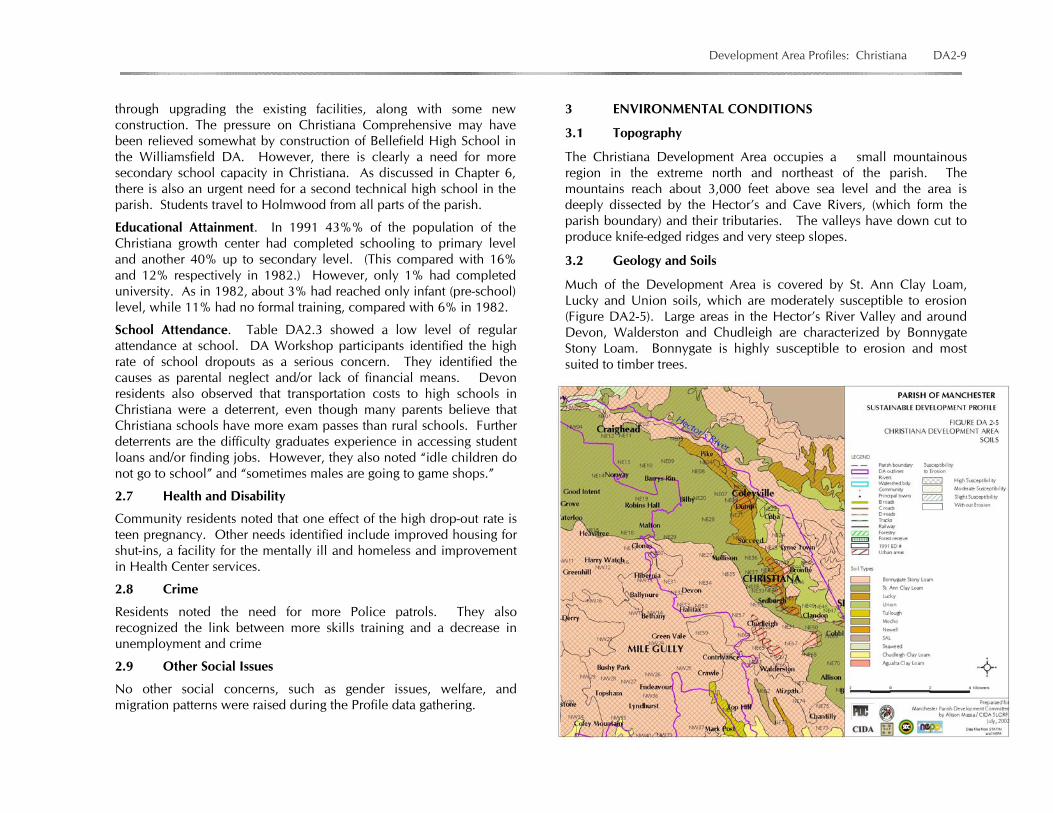
3.2 Geology and Soils
Much of the Development Area is covered by St. Ann Clay Loam, Lucky and Union soils, which are moderately susceptible to erosion (Figure DA2-5). Large areas in the Hector’s River Valley and around Devon, Walderston and Chudleigh are characterized by Bonnygate Stony Loam. Bonnygate is highly susceptible to erosion and most suited to timber trees.

DA2-10 Parish of Manchester Sustainable Development Profile
3.3 Hydrology
The mountains abound with streams of running water. Hector’s River rises in Cockpit Country and flows westwards, forming the northern boundary of the parish.
Figure DA2-5 A surface stretch of Hector’s River The east-flowing Cave River is the leading supply of domestic water for Christiana and Spalding. It is part of a generally east-flowing drainage that is gradually “beheading” the westward-flowing drainage. The Christiana DA contains the Goury Cave system.
Figure DA2-6 Farms and Forest near Walderston
3.4 Vegetation
The area is covered with mixed herbaceous woodland and shrubland subsistence plantation and with disturbed lowland montane seasonal evergreen forest. Cultivation is steadily eaten into the forest (see Figure DA2-6). A large area south of Hector’s River is designated a forestry area (see Figure DA2-2).
3.5 Wildlife Habitat (and critical species) (information required)
3.6 Environmental Issues
Deforestation and disturbance of erodible soils are having serious effects. Yam cultivation is especially damaging because it disturbs steep slopes and, in its traditional form, uses
St. Ann Clay Loam (“red bauxite” soil) covers the eastern edge of thelimestone is, normally a deep very well drained red, acid soil of lowfertility, poor water retaining ability and varying in depth. Bonny Gate Stony Loam is a friable brown clay loam of no agricultural
potential. Wherever possible it should be left in natural forest.
Figure DA2-7 Yam cultivation near Pike

Development Area Profiles: Christiana DA2-11
The 1965 Soil Survey of Manchester, referred to in Chapter 4, recommended “The mountains should be in tree crops, timber, food trees and coffee with cocoa in sheltered areas suitable to those crops. Improved pasture grass and the cultivation of food crops on gentle slopes could be incorporated into the system provided the necessary conservation methods are carried out. Timber planting on some of the most badly degraded lands would have a very beneficial effect.”
Another prevalent environmental problem is inadequate garbage collection and disposal. This results in burning of garbage and the dumping of garbage and dead animals at inappropriate sites, including the Brockery River. Due to improper garbage disposal, there has been an increase in mosquitoes and rats in urban areas like Brockery.
The rivers, Hector’s, Cave, Brockery and Dunco, are all in danger of becoming badly polluted. Garbage disposal is one cause but increasing densities and lack of sewage treatment are also responsible.
Understanding of Environmental Matters. Residents of the districts participating in the Profile data gathering and residents from throughout the DA at the DA Workshop all showed an understanding of environmental issues, including: danger of bush fires, soil erosion, soil degradation and loss of nutrients, the need to plant sustainable trees “for domestic use and
enhance the lushness of our environment. Suggested trees that can be grown within 2-3 years are quick stick, fig, sweetwood, plum, and bamboo,” and
poor management of garbage.
4 SETTLEMENT AND LAND USE
4.1 Settlement Pattern
The settlement pattern of the Christiana urban area is influenced by its hilly terrain and the large amount of government land. There are few significant expanses of available land, resulting to a linear pattern, extending from just above the town centre into Sedburgh. There are higher density settlement nodes in sections of Straun Castle, Sedburgh and Chudleigh, where the land is relatively flat.
North of Christiana itself, there are small nodes along the main road, including Coleyville, Craighead, Pike and Auchtembeddie.
The growth area includes two of the parish's largest land settlements, both in Chudleigh/ Straun Castle. This type of development encourages dispersed settlement pattern due to the "homestead-like' developments that allow adequate land space for farming. Other rural farming communities include Mollison, Harry Watch, Hibernia and Devon to the north and west and Walderston to the south.
4.2 Existing Land Use
Christiana is a residential and market town, which also offers a number of business and personal services but virtually no industry. Commercial, office and public uses are densely concentrated in the town center and in recent times have extended in a linear pattern along the Christiana main road. The town has very little public open space and play area.
Rural land use is heavily agricultural, growing potatoes, cabbage, yams and other ground provisions. There are many forest remnants and an extensive area of forest south of Hector’s River.
There is no evidence of bauxite mining in the Development Area but limestone mining is extensive near Chudleigh.
Figure DA2-7 View of Christiana from the south
Figure DA2-8 View south of Christiana
DA2-12 Parish of Manchester Sustainable Development Profile
4.3 Historical Features
The DA is filled with historical sites, including a number of Moravian churches, from Mizpah to Craighead, and the Hotel Villa Bella. In Christiana itself, management of traffic, parking and market activities will reveal a number of impressive 19th Century structures. These should be treated as important historic structures with potential for restoration once the town regains some of its former tourism function. 5 CULTURE
Relatively little information on the aspects of the culture and cultural history of the Christiana DA was provided. Space is provided in the following categories to encourage further contributions.
5.1 Folklore and Stories …………………………………………………. …………………………………..……………………………………………………………………………………………………………………………………………..
5.2 Music, Entertainment and Games. Up to the 1980s, cricket and football games were played at holday community fairs. Until the early 1990s, boys and girls played karate, marbles, bush war with play guns, and cricket with bats made from coconut bow and balls made from melted plastic bags. Girls skipped and played dandy shandy. ………………………………………………………………………………………………………………………………………………………………
5.3 Medicines. Fevergrass was used for fever, Sarsparilla for tonic. ……………………………………………………………………………….. ……………………………………………………………………………………………………………………………………………………………………………………
5.4 Food. Rice & peas, cowfoot, pork and beef were the famous dishes. Salting was done to preserve meat and fish. …………………. ……………………………………………………………………………….……………………………………………………………………………
5.5 Crafts. White lime and dirt were used for building construction until the 1930s. Roof shingles made from cedarwood were popular. Roofs were made with a hip shape. ………………………. ……………………………………………………………………………………………………………………………………………………………………………………
6 SOCIAL ORGANIZATION
6.1 Community Organizations and Leadership
Christiana has active service clubs, especially The Rotary Club, a tradition of agricultural ad marketing (The Christiana Potato growers’ Association) and an increasingly active Development Area Committee. However, there is a need for more organized and structured community organizations in rural communities, as well as training for leaders in how to run organizations effectively. At the time of data gathering Devon citizens were making efforts to revive the Devon Community Club. In particular, they aimed to get young persons to play major roles in club development, obtain land from Devon High School for the 4H Club, and get help with community center repairs. Walderston residents were beginning a Community Development Committee, while Brockery citizens said they needed to start a CBO. 7 COMMUNITY PLANNING AND INFRASTRUCTURE
Community Development. Christiana residents identified the following community service/facility needs: A community center and playfield (Brockery); A facility for mentally ill & homeless; Improvement in housing conditions for shut-ins; Police patrols; Improved Health Center services; A mobile library to serve communities far from Christiana.
Water. See Section 2.6.
Power and Communications. See Section 2.6.
Street Lights. DA Workshop participants noted the need for more streetlights and a fire hydrant in the housing scheme.
Road Improvements and Transportation. Numerous concerns were raised during data gathering and at the DA workshop.
The primary need is for a bypass route to help reduce vehicular and pedestrian congestion in central Christiana. Sometimes it can take up to three hours to get from Apple Tree Plaza to the Police station, a distance covered in less than five minutes without congestion.
Development Area Profiles: Christiana DA2-13
Table DA2.4 Christiana Timeline
Year Event / Recollection / Condition 1800s Mt. Olivet Presbyterian, Chantilly Anglican and Mizpah Moravian Churches were founded. 1838 The Herons owned lands. They sold some after slavery was abolished to a German (Moravian) family named Walder. Most of the land was stony. Mid 1800s Christiana was originally called Straun Castle. It was renamed in the mid-19th C after the wife of a Scottish settler named Allen. After the Morant Bay rebellion, a barracks for English soldiers was established at Christiana. Later, some Chinese and Indians came to Christiana. The town rapidly grew around the Christiana market. The town was connected to the railway by a road built to the Kendal station by Reverend Walder. The picturesque, cool area became a health and tourist area. Visitors were mostly European and the local elite. The Governor spent many holidays at the
"Lodgins," guesthouse. Later, Villa Bella Hotel and Hotel Savoy were built. The latter had tennis courts and hosted a weekly tennis tournament. 1920s School Inspectors, including a Mr. Virtue, used to go around to all the schools. 1930s Roads and electricity came through the Walderston area. Chappy Lord was the first man to get electricity. Horse-drawn buggy was a popular form of transportation. People bought land from the Herons for £1 per acre. Bananas grown on a large scale and sold to persons at Kendal. 1933 A hurricane destroyed trees and roofs. 1939 Persons from the area went to fight World War II. Mr. Virtue joined the Royal Air Force (RAF). Farm products were sold at the Walderston market. Persons from as far afield as St. Elizabeth came to buy products at this market. 1940s Devon was more developed than Christiana. There was a bakery, police station, market, post office, gas station, and P.C. bank Alcan accelerated the growth of the town of Christiana. The roads were paved and electricity introduced in the 1940s. 1940s More persons were recruited for World War II to farm in the United States The Panama disease and the transport problems of World War II saw a great decline in the banana industry. 1945 The Walderston Market ended. Ginger cultivation succeeded banana production, which was itself replaced by the production of "Irish" potatoes. 1951 Hurricane Charlie. Roofs were lost, Late 1950s The whites, Blacks, Indians and Lebanese got along so well that the Christiana area was cited by the United Nations as a model for good race relations. 1960 The Shoter’s Hill Road opened; since then accidents keep happening. 1969 Mt. Olivet School was removed . to its present location. Long Coffee got its name because of the amount of coffee that use to grow there. 1970s The Bauxite company came into the Devon area and bought lands. 1970s Taxi and Graham Bus were the main source of transportation. 1970s No money, no food. Kerosene became scarce, castor oil had to be used for light. This continued until election. This was a sad time.
1976 Police Station was moved from Devon. 1980 This was an election year -- very violent. After the election electricity came. 1988 Hurricane Gilbert affected the community; some persons got help by getting zincs but some persons got no help at all. 1993 Telephone service.came to Devon. 1980 The Pike Radar Centre at Denham Road was built by the Irish Government -- approximately 150ft high. 1980 No piped water in homes. 1998 Water storage tank was built at Mt. Olivet School. 1998 Devon taxi operators pooled together and patched the roads. 2000 Basketball and football became popular sports; and cellular took over from house phones.
DA2-14 Parish of Manchester Sustainable Development Profile
Bus and taxi operators stop in the road to collect and let off passengers, causing traffic problems. Signed bus and taxi cutouts and regulations are needed to augment the existing transportation center and new car parks.
Other road improvement needs (Spring 2002) include: Mollison: need for completion of a project on the road from the market to Mollison (funds were approved in 2001 but only a fraction of the work was done). Brockery: the road leading from the Old Housing Scheme. Devon: the roads from Devon to Bethany and from Devon to Halifax (“JSIF inspected 3 years ago but nothing has happened”). Walderston: Road from the main reading to the Mt. Olivet School; Stop lights are needed at the Walderston junction. Pike: the road off the main via the bridge at Hector’s River through New Road to Wait-a-Bit (4 miles) is urgently in need of attention.
Many districts and communities are willing to contribute help. For example, in Devon in the late 1990s, taxi operators pooled together and patched the roads themselves. Residents also have recommendations for improving the quality of road construction and repair. The following emerged from the DA Workshop: Zone the roadwork—concentrate on one zone until completion; Make adequate provision for drainage; NWA/Parish Council need to ensure supervision of projects; Include street and directional signs with major road repair; Agencies need more effective Public Relations functions to
facilitate community performance feedback.
The issue of transportation cost and the need for public transportation was not as great in Christiana as in some other DAs. However, brockery residents complained that the cost of transportation is too high -- “persons pay $150 and over from Christiana to Brockery.”
8 ECONOMIC DEVELOPMENT
Christiana is a heavily agricultural area with banana, ginger, yam, sweet potatoes and other root crops being cultivated. The following is a summary of agricultural activities and concerns from the sample communities:
Brontie: Since about 1980 there has been a decline in agricultural activities. Some persons who did farming are now retired or pensioners. The JAS group has not impacted on the community, and RADA only a little. Brockery: Vegetables do well in Brockery, as the soil type is clay (St. Ann) and “said to be strong to hold farm produce”. Yams are grown on a small scale. “Persons do farming as another means of livelihood, however, sales are very slow.” Devon: 95% of farmers in the community farm on a large scale (more than one acre). 30% of the farmlands are leased from the bauxite company or GOJ. Crops grown are vegetables, yams, Irish potatoes. Higglers from St. Elizabeth, Trelawny, Christiana and other areas come in and buy farm products. Mollison; Major crops planted; Irish potatoes, yams, carrots, tomato, and lettuce. Farmers have difficulty selling farming produce. The community members feel that there is a need for consultation with manufacturing companies such as Grace, Eve, and the local supermarket to discuss ways and means of using their produce. They want to find out why farmers are not benefiting from these local markets. Pike: New Road is a farming district, 75% of the land-space is used for farming, crops grown include; yams, banana, Irish potatoes, carrots and cabbages. Mangoes only bear every five years. Yams are sold to higglers, local markets or export groups in Kingston.
The Economic Development group at the Christiana DA Workshop was made up of representatives from Chudleigh, Devon, Contrivance, Chantilly, Coleyville, aged from 16 to 55. They identified the following common issues affecting agriculture and economic development in Christiana DA communities: 1. Agriculture in decline; 2. Decline in particular produce, e.g., cabbage, Irish potato, corn; 3. Difficulty selling farm produce; 4. Low prices; 5. JAS/RADA has no impact in motivating farmers; 6. Praedial larceny; 7. Over production of a particular crop;

Development Area Profiles: Christiana DA2-15
8. Transportation cost high; 9. High cost of agricultural production; 10. Cost of power hinders industrial development.
Solutions identified included: Farmers need to do more seasonal farming, i.e., producing
different produce at different times. RADA can improve by providing new information on relevant
crop and resources/technical assistance. It could also assist with finding financing and establishing vegetable growers’ cooperatives.
Community policing and citizen involvement are necessary to combat praedial larceny.
The overall problem of unemployment raised another set of recommendations: There is a need for better-focused skills training in schools; The Ministry of Education needs to be approached regarding to
appointing skills training instructors in selected schools;
There is a need for more publicity about the benefits of skills training because many school dropouts and unemployed adults have “wrong ideas about skill training centres;”
The DA needs a JAMAL/skill training center; The YWCA needs to be contacted to find out the reasons for the
closing down of the training center. The Rotary Club and Heart/NTA to think of possible extensions of
training opportunities (apprenticeships, etc.);
Brockery residents identified the cleaning up of the Dunco River and construction of a drive-in entrance as a development project, allowing the community to profit from the Waterfalls and bathing pool. They also explored ideas for cottage industries or a bi-product factory. The recommendations illustrate the fact that more work needs to follow the Profile data gathering and the DA Workshop. These activities marked the very effective start of what needs to be a process of identifying and developing opportunities for building on the resources of the DA for new as well as traditional industries. Figure DA2-9 is a reminder of the area’s potential for community tourism.
Add other ideas for agricultural production, agro-processing, eco-tourism and community tourism, trade and other development prospects: ………………………………………………………………………….. ……………………………………………………………………………………………………………………………………………………………………………………………………………………………………………………………………………… 9 INDICATORS AND MEASURES OF SUSTAINABILITY
(To be added during the Visioning and Planning process.)
10 DA WORKSHOP AND EARLY ACHIEVABLE TASK PLANS
The EATs plans created by the Christiana Development Area community residents at their planning workshop on January 17, 2002 addressed the following topics: Reluctance of community to participate in activities of CBO/Non existence of a CBO; The Need fore a Skills Training Center; JAS/RADA’s lack of impact on communities in the DA; Irregular supply of water. The topics were developed after prioritizing and “unpacking” the list of common issues arising during the interventions. (See Annex B.)
Figure DA2-9 View from Top Hill
DA2-16 Parish of Manchester Sustainable Development Profile
ANNEX A NEPA DRAFT DEVELOPMENT ORDER: PROPOSALS FOR THE CHRISTIANA LOCAL PLANNING AREA TRANSPORTATION TRANSPORTATION CENTRE Christiana is very busy in terms of vehicular trips being made in and out on a daily basis. This has given rise to critical problems regarding the movement of vehicular and pedestrian due to the narrowness of the roads. The town is served by a public transportation centre adjacent to the market. In spite of this, the majority of public passenger vehicles insist on picking up and letting off passengers on the service station property along the main road, thus obstructing the free flow of traffic. The densely developed town allows for little or no parking, and provides little pedestrian facilities. Hence, there is a need to improve the existing transportation facilities. This could be achieved by creating a public car park in the vicinity of the market and regulating access to and from the petrol filling station. The drivers of public passenger vehicles would then be forced to use the transportation centre for the purpose for which it was intended. POLICY CT 1 The local planning authority will support the
upgrading of the existing transportation centre by the establishment of a car park on adjoining lands along with the necessary sanitary facilities.
VEHICULAR PARKING The recently constructed developments within the town have attempted to provide customer parking spaces on their compound. This trend will have to continue if the situation is to be improved. The authorities in approving development applications will therefore ensure that the required standards are conformed to. POLICY CT 2 The planning authority will not grant planning
permission for any new development or extension unless parking is provided in accordance with requirements set out in the appendices to this order.
ROAD NETWORK Christiana’s existing road pattern is insufficient to support its --daily activities. The network consists of one major road having a single lane in both directions, two secondary roads and several access roads which are often in poor condition, narrow and hilly. These access routes are vital to the transportation of agricultural goods into the town. The pattern can be described as almost spiral, having all roads leading directly into the town centre, thus adding to the chaotic situation that already exists. Developments along these roads should be set back so that they can be widened in the future. POLICY CRN 1 Thyme Town, Chudleigh, Coleyville, Ticky Ticky,
Mollison, Straun Castle and the Main Road will need improvement and all developments along the minor roads should be set back a minimum of 9.1 metres from their centre line and the main road 12.1 metres to allow for this.
URBAN ECONOMY This local planning area is well served with commercial and various office activities which are concentrated in the town centre and is now extending in a linear pattern along the Christiana main road. As a result the surrounding areas including Coleyville, Shooters Hill and Mile Gully rely on the goods and services offered here. There is therefore a high employment rate with the majority of jobs being in the service sector. The people experiencing high unemployment are mostly those on the periphery. However this is not due to job shortage but lack of skill and qualifications required for the positions. Industrial activities are visibly lacking in the area and this should be encouraged to provide employment and make use of the agricultural resources available. POLICY CUE 1 Agro Industrial development will be supported on
sites where they are compatible with the surroundings in areas such as Straun Castle and Chudleigh.
Development Area Profiles: Christiana DA2-17
Because of the concentration of development in Christiana and the difficulty being experienced in moving around it is necessary that commercial activities be decentralized to ease the situation. A good location in which this could take place is at Sedburgh where land is available and it is easily accessible to the population. POLICY CUE 2 The planning authority will support the establishment
of commercial developments at Sedburgh in the area shown on the land use proposals map for the purpose.
SOCIAL AMENITIES Christiana as the only sub-regional centre in the parish has the majority of social services that is required of it. However great stress has been placed on these from the surrounding communities where they are not in existence. There is no central open space nor community centre and as such most often the school playing fields or any inconvenient vacant lots are used. There is also no facility that could be used to provide training to residents who need to improve their skills. Hence a community centre including a training centre is an urgent need for this town. POLICY CSA 1 Lands identified at ….… shall be developed as a
recreational centre with a multi-purpose building and other facilities that can be used for training purposes.
Although the town is a rapidly developing one there is no attempt or evidence of landscaping in the process. Trees planted along the side of the streets and landscaped area not only beautify the town but also provide shade and relief for the eyes from the glare of the sun. The situation therefore needs to be remedied. POLICY CSA 2 All applications especially commercial and high
density residential developments should be accompanied by a landscape plan which is to be implemented as part of the development process.
POLICY CSA 3 In all residential developments exceeding 9 lots land is to be left as open space to satisfy the recreational needs of the community in accordance with appendix.......
In the center of the town is a public cemetery, which is almost filled to capacity and which creates a traffic problem when funerals are in progress. It is recommended that a new site be identified for this purpose and the present one be landscaped and left as an open area. This would provide the town with much needed green space. POLICY CSA 4 Lands adjoining....... shall be reserved for a public
cemetery as shown on the land use plan and the planning authority will not grant permission for any other form of development on this site.
HOUSING Christiana is the highest ranked town next to Mandeville and as such enjoys a better standard of living than most of the other growth areas in the Parish. However, housing conditions are not as should be expected as in 1991 there was a deficit of approximately 307 units resulting in overcrowding conditions. This was predominant in areas such as Straun Castle, Spring Valley, Mount Prospect and Sedburgh. Although this situation exists, there is no squatting and the deficit partially made good through the further subdivision of family lots. Despite this action the houses are still well spaced with adequate yard facilities. Generally, housing development is hampered by the hilly terrain that limits suitable land for this kind of development. In recent times the southern communities including Clandon, Sedburgh and Richmond have become desirous location' for returning residents, thus making the provision of housing in these areas for middle and low income earners more costly. By the year 2015 approximately nine hundred and sixteen (916) units will be needed to house the projected population, and to replace units that will be lost from the existing housing stock. These will have to be

DA2-18 Parish of Manchester Sustainable Development Profile
provided by both private and governmental agencies in existing subdivisions and on lands reserved for housing development. POLICY CH 1 In order to provide affordable units and discourage fragmentation of subdivided lands, housing solutions including service lots and starter units will be encouraged by the planning authority. POLICY CH 2 Re-subdivision of large vacant lots, (infilling) in
residential subdivision with infrastructure will be encouraged particularly in Clandon, Sedburgh and Richmond, to allow maximum use of existing facilities.
POLICY CH 3 Residential developments will be supported by the
planning authority in areas where these are already established and where the infrastructure can support additional development.
SUBURBAN ECONOMY Outside of the township area agriculture plays a vital role to Christiana’s economy and trade. This activity represents roughly 62 per cent of the total land space and about 30% of the labour force. The major crops include yams, peas, Irish and sweet potatoes. It is recommended that supplementary activities such as agro processing be developed so as to enhance the economy and at the same time ease the stress placed on the town centre POLICY CSEC 1 Planning permission will not be granted for any
development that will result in a loss of agricultural lands or lands with agricultural potential.
POLICY CSEC 2 Agro-industry will be supported by the planning
authority and the vacant building on the Sedburgh to Spaulding main road is to be used for this purpose.
POLICY CSEC 3 Planning permission will not be granted for the conversion or fragmentation of land settlement lots especially at Chudleigh and Straun Castle into housing units or other non agricultural activities. ENERGY GENERATION The demand for electricity has risen considerably in Christiana as more modern housing units are built by the returning residents. In addition the increasing commercial activities place a great stress on the present system. As such emphasis will be placed on encouraging less energy intensive development such as agroindustry, and to discourage scattered settlements to ensure maximum and effective use of the existing electricity supply. The use of energy saving devices such as solar heaters will be encouraged in both residences and business places. POLICY CE 1 The planning authority will ensure that the design of
new buildings take into consideration energy conservation techniques.
WATER SUPPLY Less than half of the households in Christiana is connected to a piped water supply system. A substantial proportion therefore depends on catchment tanks as their source. Due to high cost associated with supplying piped water to dwellings there is no immediate plan to embark on an exercise that will make it available to everyone, in the short term. Householders will therefore have to rely on catchment tanks, until the required system can be implemented. POLICY CPW 1 The planning authority will not grant permission for
any development that does not provide for the construction of a catchment tank or other facility to satisfy water supply requirements.
WASTE TREATMENT AND DISPOSAL Like all growth centres in Manchester the Christiana local planning area has no central sewerage system and it is unlikely that there will be any in the near future. This is due mainly to the lack of adequate
Development Area Profiles: Christiana DA2-19
piped water supply system. Liquid waste treatment and disposal will therefore have to rely on improvement to traditional methods. Where water is available the preferred method of disposal will be by septic tank and absorption pits. Where there is no water then house owners will have to resort to ventilated improved pit latrines and ordinary pit latrines. The latter facilities if properly constructed will ensure satisfactory environmental qualities. POLICY CWT 1 To ensure safe and sanitary conditions of
development the planning authority will approve the disposal of sewage by means of septic tanks and absorption pits, ventilated improved pit latrines, pit latrines or any other suitable system that may be developed.
MINING The quarrying of limestone for use in block making and other building activities is done at Chudleigh. Since areas close to quarrying operations tend to experience dust and noise pollution care has to be taken in their operation. They also usually leave a visible scar on the landscape that has to be remedied. POLICY CM 1 Where quarrying operations have occurred the
rehabilitation or restoration of the quarried area should be undertaken to such a stage where it can be used for other purposes.
POLICY CM 2 Where quarrying operations leave a scar on the
landscape the area is to be re vegetated with quick growing and hardy landscape material.

DA2-20 Parish of Manchester Sustainable Development Profile
ANNEX B CHRISTIANA WORKSHOP AND EARLY ACHIEVABLE TASK PLANS SOCIAL -- Facilitators: Stephanie Hutchinson & Janice Hart Within the Christiana community there were social issues that needed to be looked at and they were as follows: Community reluctant to participate in community club Parents send children to school in Christiana (High schools are in Christiana *transportation cost, but idle children do not go to school sometimes
males are going to game shops). School drop out (high) due to parental neglect and/or means (no means) Cause-Overall finance, Effect- girls get pregnant. Many graduates can’t access students loan Lack of employment especially for school leavers Need JAMAL/skill training centre Services needed for mentally ill vagrants Need improved housing conditions for shut-ins Need police patrol Need health center
In order to determine whether these issues could be dealt with on a short-term or long-term basis, participants voted. Time was available to discuss only one of the issues in terms of looking at the underlying reason for reluctance of community to participate in CBO.
Issues Voting Total Short Term
Long Term
Discussion on Short-term issue
Need for skills training centre 6 Reluctance of community to participate in CBO 6 Reasons for this problem:
Self interest Selfishness Indiscipline Past failures Lack of commitment Not motivated CBO does not meet goals Politics Time/clash of activities Leadership style Lack of strong leadership
Cost of transportation to send children to High Schools 4 Inability to access student Loans - Lack of employment for school leavers
8
Facility for mentally ill & homeless 2 Improvement in housing conditions for shut-ins 1 Need Police patrol 3 Need improvement in Health Centre Services 6

Development Area Profiles: Christiana DA2-21
INFRASTRUCTURE -- Facilitator: Joel Campbell & Kenton Davis These issues were ranked on a scale of 1–5, 1 being the most needed, and 5 being the least needed. After participants ranked the issues, the rankings were tallied to determine issues needing immediate attention. Those issues were placed in three categories reflecting the time frame for attention.
Issue Ranking Total Short Term
Medium Term
Long Term
Discussion/Steps in achieving these goals
• Dunco River/ waterfall needs cleaning (not sure about this information)
• Need electricity for Long Coffee (power is running through some parts of the district)
• Need more household telephones 25 • Need improved Community Centre 17
• Need playfield 15 • Library
10 Due to the fact that some communities are far out of the town of Christiana, a mobile library would be a plus. A time would be established for each community/district, to use the services and this would be advertised through J.I.S.
• Health Centre 10 Expand and refurbish the current existing health centre. Look at a possible survey to determine need for expansion.
• Improved housing conditions for shut-ins 23
• Skills training centre
7 To link with the Rotary Club and Heart NTA to think of possible extension of training opportunities
Link with the YWCA to find out the reasons for the closing down of the training centre that was previously there.
Possibility of approaching the Ministry of Education to appoint instructors in appointed schools to offer skills training.
• JAMAL 9 • More street lights 12 • More directional signs 10 • More parking areas 13 • Major roads need repairs
9 Zone the roadwork—concentrate on one zone until completion
NWA/Parish Council to ensure supervision for work project Make effective Public Relations am agencies to give community
performance feedback. N.B. Street signs to be included with major road repair
• Monitoring of garbage collection needed 15 • Drains need cleaning/repair 19 • Water supply irregular • [Need] Piped water
13
DA2-22 Parish of Manchester Sustainable Development Profile
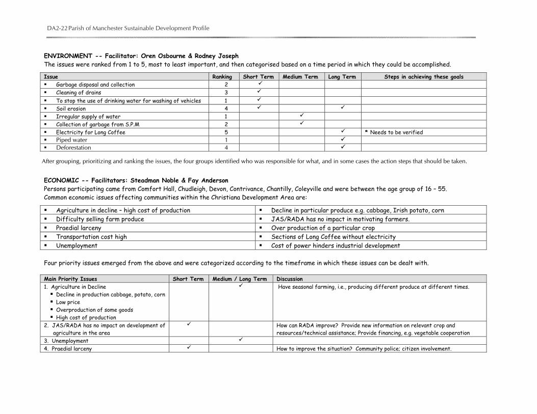
ENVIRONMENT -- Facilitator: Oren Osbourne & Rodney Joseph The issues were ranked from 1 to 5, most to least important, and then categorised based on a time period in which they could be accomplished.
Issue Ranking Short Term Medium Term Long Term Steps in achieving these goals Garbage disposal and collection 2 Cleaning of drains 3 To stop the use of drinking water for washing of vehicles 1 Soil erosion 4 Irregular supply of water 1 Collection of garbage from S.P.M 2 Electricity for Long Coffee 5 * Needs to be verified Piped water 1 Deforestation 4
ECONOMIC -- Facilitators: Steadman Noble & Fay Anderson Persons participating came from Comfort Hall, Chudleigh, Devon, Contrivance, Chantilly, Coleyville and were between the age group of 16 – 55. Common economic issues affecting communities within the Christiana Development Area are:
Agriculture in decline – high cost of production Decline in particular produce e.g. cabbage, Irish potato, corn Difficulty selling farm produce JAS/RADA has no impact in motivating farmers. Praedial larceny Over production of a particular crop Transportation cost high Sections of Long Coffee without electricity Unemployment Cost of power hinders industrial development
Four priority issues emerged from the above and were categorized according to the timeframe in which these issues can be dealt with.
Main Priority Issues Short Term Medium / Long Term Discussion 1. Agriculture in Decline Decline in production cabbage, potato, corn Low price Overproduction of some goods High cost of production
Have seasonal farming, i.e., producing different produce at different times.
2. JAS/RADA has no impact on development of agriculture in the area
How can RADA improve? Provide new information on relevant crop and resources/technical assistance; Provide financing, e.g. vegetable cooperation
3. Unemployment 4. Praedial larceny How to improve the situation? Community police; citizen involvement.
After grouping, prioritizing and ranking the issues, the four groups identified who was responsible for what, and in some cases the action steps that should be taken.
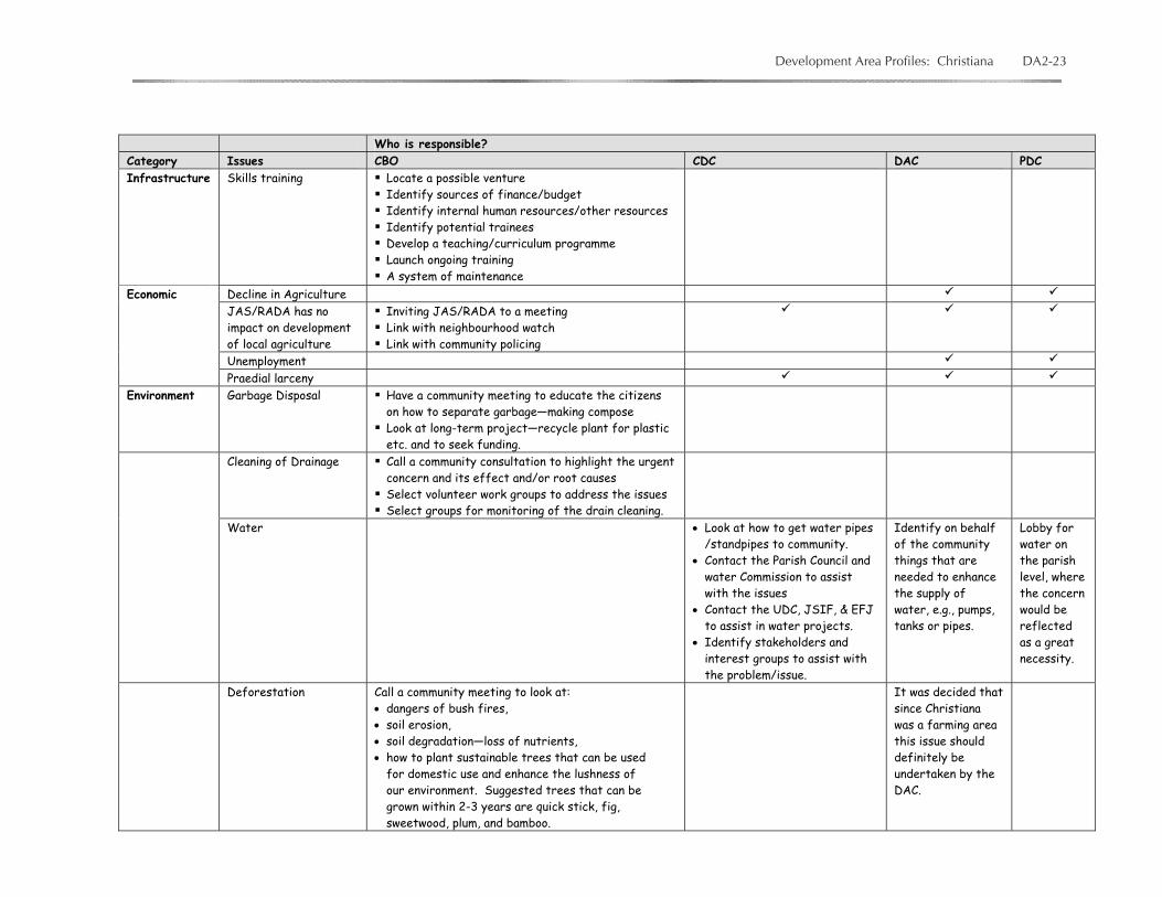
Development Area Profiles: Christiana DA2-23
Who is responsible? Category Issues CBO CDC DAC PDC Infrastructure
Skills training Locate a possible venture Identify sources of finance/budget Identify internal human resources/other resources Identify potential trainees Develop a teaching/curriculum programme Launch ongoing training A system of maintenance
Decline in Agriculture JAS/RADA has no impact on development of local agriculture
Inviting JAS/RADA to a meeting Link with neighbourhood watch Link with community policing
Unemployment
Economic
Praedial larceny Environment Garbage Disposal
Have a community meeting to educate the citizens on how to separate garbage—making compose Look at long-term project—recycle plant for plastic etc. and to seek funding.
Cleaning of Drainage Call a community consultation to highlight the urgent concern and its effect and/or root causes Select volunteer work groups to address the issues Select groups for monitoring of the drain cleaning.
Water • Look at how to get water pipes /standpipes to community.
• Contact the Parish Council and water Commission to assist with the issues
• Contact the UDC, JSIF, & EFJ to assist in water projects.
• Identify stakeholders and interest groups to assist with the problem/issue.
Identify on behalf of the community things that are needed to enhance the supply of water, e.g., pumps, tanks or pipes.
Lobby for water on the parish level, where the concern would be reflected as a great necessity.
Deforestation Call a community meeting to look at: • dangers of bush fires, • soil erosion, • soil degradation—loss of nutrients, • how to plant sustainable trees that can be used
for domestic use and enhance the lushness of our environment. Suggested trees that can be grown within 2-3 years are quick stick, fig, sweetwood, plum, and bamboo.
It was decided that since Christiana was a farming area this issue should definitely be undertaken by the DAC.
DA2-24 Parish of Manchester Sustainable Development Profile
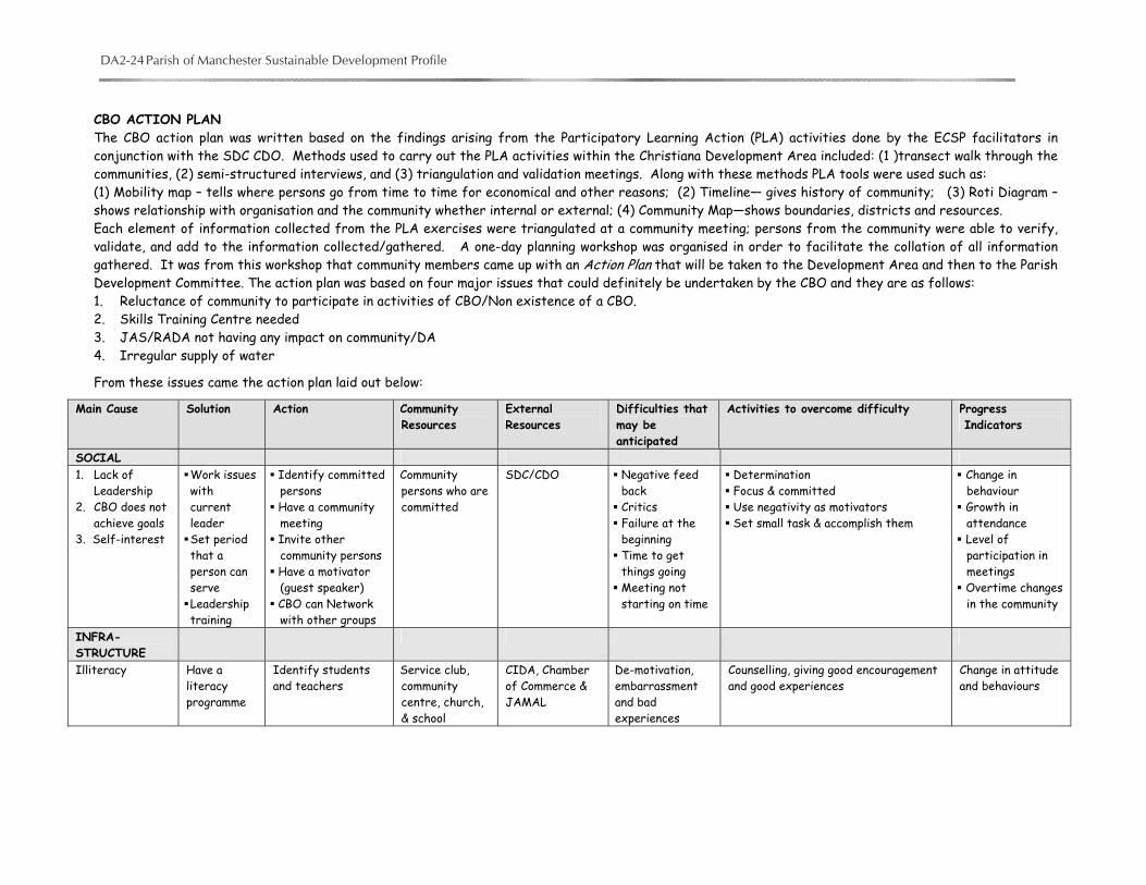
CBO ACTION PLAN The CBO action plan was written based on the findings arising from the Participatory Learning Action (PLA) activities done by the ECSP facilitators in conjunction with the SDC CDO. Methods used to carry out the PLA activities within the Christiana Development Area included: (1 )transect walk through the communities, (2) semi-structured interviews, and (3) triangulation and validation meetings. Along with these methods PLA tools were used such as: (1) Mobility map – tells where persons go from time to time for economical and other reasons; (2) Timeline— gives history of community; (3) Roti Diagram – shows relationship with organisation and the community whether internal or external; (4) Community Map—shows boundaries, districts and resources. Each element of information collected from the PLA exercises were triangulated at a community meeting; persons from the community were able to verify, validate, and add to the information collected/gathered. A one-day planning workshop was organised in order to facilitate the collation of all information gathered. It was from this workshop that community members came up with an Action Plan that will be taken to the Development Area and then to the Parish Development Committee. The action plan was based on four major issues that could definitely be undertaken by the CBO and they are as follows: 1. Reluctance of community to participate in activities of CBO/Non existence of a CBO. 2. Skills Training Centre needed 3. JAS/RADA not having any impact on community/DA 4. Irregular supply of water
From these issues came the action plan laid out below:
Main Cause Solution Action Community Resources
External Resources
Difficulties that may be anticipated
Activities to overcome difficulty Progress Indicators
SOCIAL 1. Lack of
Leadership 2. CBO does not
achieve goals 3. Self-interest
Work issues with current leader Set period that a person can serve Leadership training
Identify committed persons Have a community meeting Invite other community persons Have a motivator (guest speaker) CBO can Network with other groups
Community persons who are committed
SDC/CDO Negative feed back Critics Failure at the beginning Time to get things going Meeting not starting on time
Determination Focus & committed Use negativity as motivators Set small task & accomplish them
Change in behaviour Growth in attendance Level of participation in meetings Overtime changes in the community
INFRA-STRUCTURE
Illiteracy
Have a literacy programme
Identify students and teachers
Service club, community centre, church, & school
CIDA, Chamber of Commerce & JAMAL
De-motivation, embarrassment and bad experiences
Counselling, giving good encouragement and good experiences
Change in attitude and behaviours
Development Area Profiles: Christiana DA2-25
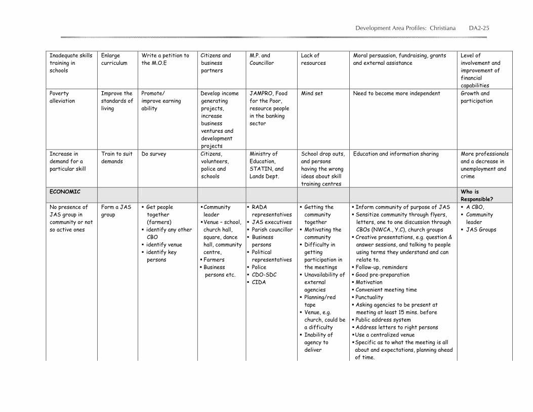
Inadequate skills training in schools
Enlarge curriculum
Write a petition to the M.O.E
Citizens and business partners
M.P. and Councillor
Lack of resources
Moral persuasion, fundraising, grants and external assistance
Level of involvement and improvement of financial capabilities
Poverty alleviation
Improve the standards of living
Promote/ improve earning ability
Develop income generating projects, increase business ventures and development projects
JAMPRO, Food for the Poor, resource people in the banking sector
Mind set Need to become more independent Growth and participation
Increase in demand for a particular skill
Train to suit demands
Do survey Citizens, volunteers, police and schools
Ministry of Education, STATIN, and Lands Dept.
School drop outs, and persons having the wrong ideas about skill training centres
Education and information sharing More professionals and a decrease in unemployment and crime
ECONOMIC Who is Responsible?
No presence of JAS group in community or not so active ones
Form a JAS group
Get people together (farmers) identify any other CBO identify venue identify key persons
Community leader Venue – school, church hall, square, dance hall, community centre, Farmers Business persons etc.
RADA representatives JAS executives Parish councillor Business persons Political representatives Police CDO-SDC CIDA
Getting the community together Motivating the community Difficulty in getting participation in the meetings Unavailability of external agencies Planning/red tape Venue, e.g. church, could be a difficulty Inability of agency to deliver
Inform community of purpose of JAS Sensitize community through flyers, letters, one to one discussion through CBOs (NWCA., Y.C), church groups Creative presentations, e.g. question & answer sessions, and talking to people using terms they understand and can relate to. Follow-up, reminders Good pre-preparation Motivation Convenient meeting time Punctuality Asking agencies to be present at meeting at least 15 mins. before Public address system Address letters to right persons Use a centralized venue Specific as to what the meeting is all about and expectations, planning ahead of time.
A CBO, Community leader JAS Groups

DA2-26 Parish of Manchester Sustainable Development Profile
ENVIRONMENT • Inadequate source from Moravia Plant
• Removal of pipeline/pumps
• Increase and improve water supply, e.g. from spring in Allison
• Laying of new and bigger pipes
• Collective efforts • Community
meetings • Stakeholder and
community meetings
• Fundraising done in the community
• Build more water catchments
• Labourers in the community (skilled/ unskilled)
• Businesses
• N.W.C • Parish Council • Ministry of
Water • M.P. • Councillor • Business
Communities • International
Funding Agencies
Section 3 -- Capacity Building
a. Partnership Building Internal External 1. employment of interactive programme cultural exchange
2. non segregation sharing ideas, best practices
3. a sense of belonging giving each persona say irrespective of status
b. Accountability -- What actions can improve accountability? 1. Keep accurate records; 2. Involve follow up activities; 3. Ensure credibility and transparency to avoid mistrust; 4. Identify persons to be in charge of various activity areas.
c. Transparency 1. Proper communication; 2. Periodic reports; 3. Recording; 4. Newsletters; 5. Teamwork/collective effort in all activities; 6. Clearly define your objectives -- what you intend to achieve.
Development Area Profiles: Christiana DA2-27
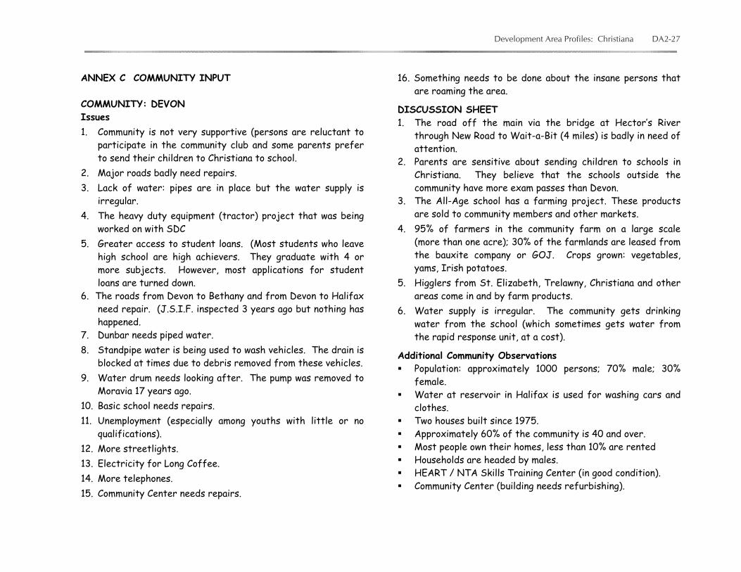
ANNEX C COMMUNITY INPUT COMMUNITY: DEVON Issues 1. Community is not very supportive (persons are reluctant to
participate in the community club and some parents prefer to send their children to Christiana to school.
2. Major roads badly need repairs. 3. Lack of water: pipes are in place but the water supply is
irregular. 4. The heavy duty equipment (tractor) project that was being
worked on with SDC 5. Greater access to student loans. (Most students who leave
high school are high achievers. They graduate with 4 or more subjects. However, most applications for student loans are turned down.
6. The roads from Devon to Bethany and from Devon to Halifax need repair. (J.S.I.F. inspected 3 years ago but nothing has happened.
7. Dunbar needs piped water. 8. Standpipe water is being used to wash vehicles. The drain is
blocked at times due to debris removed from these vehicles. 9. Water drum needs looking after. The pump was removed to
Moravia 17 years ago. 10. Basic school needs repairs. 11. Unemployment (especially among youths with little or no
qualifications). 12. More streetlights. 13. Electricity for Long Coffee. 14. More telephones. 15. Community Center needs repairs.
16. Something needs to be done about the insane persons that are roaming the area.
DISCUSSION SHEET 1. The road off the main via the bridge at Hector’s River
through New Road to Wait-a-Bit (4 miles) is badly in need of attention.
2. Parents are sensitive about sending children to schools in Christiana. They believe that the schools outside the community have more exam passes than Devon.
3. The All-Age school has a farming project. These products are sold to community members and other markets.
4. 95% of farmers in the community farm on a large scale (more than one acre); 30% of the farmlands are leased from the bauxite company or GOJ. Crops grown: vegetables, yams, Irish potatoes.
5. Higglers from St. Elizabeth, Trelawny, Christiana and other areas come in and by farm products.
6. Water supply is irregular. The community gets drinking water from the school (which sometimes gets water from the rapid response unit, at a cost).
Additional Community Observations Population: approximately 1000 persons; 70% male; 30%
female. Water at reservoir in Halifax is used for washing cars and
clothes. Two houses built since 1975. Approximately 60% of the community is 40 and over. Most people own their homes, less than 10% are rented Households are headed by males. HEART / NTA Skills Training Center (in good condition). Community Center (building needs refurbishing).
DA2-28 Parish of Manchester Sustainable Development Profile
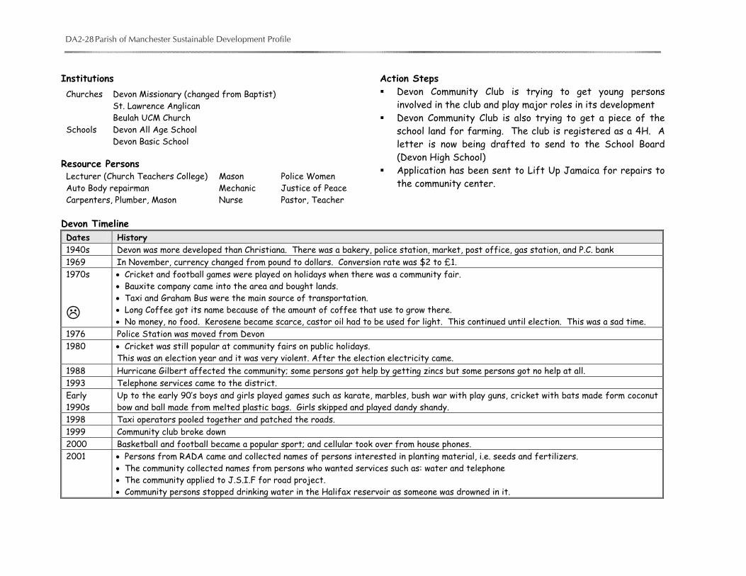
Institutions
Resource Persons Lecturer (Church Teachers College) Mason Police Women Auto Body repairman Mechanic Justice of Peace Carpenters, Plumber, Mason Nurse Pastor, Teacher
Action Steps Devon Community Club is trying to get young persons
involved in the club and play major roles in its development Devon Community Club is also trying to get a piece of the
school land for farming. The club is registered as a 4H. A letter is now being drafted to send to the School Board (Devon High School)
Application has been sent to Lift Up Jamaica for repairs to the community center.
Devon Timeline Dates History 1940s Devon was more developed than Christiana. There was a bakery, police station, market, post office, gas station, and P.C. bank 1969 In November, currency changed from pound to dollars. Conversion rate was $2 to £1. 1970s
• Cricket and football games were played on holidays when there was a community fair. • Bauxite company came into the area and bought lands. • Taxi and Graham Bus were the main source of transportation. • Long Coffee got its name because of the amount of coffee that use to grow there. • No money, no food. Kerosene became scarce, castor oil had to be used for light. This continued until election. This was a sad time.
1976 Police Station was moved from Devon 1980 • Cricket was still popular at community fairs on public holidays.
This was an election year and it was very violent. After the election electricity came. 1988 Hurricane Gilbert affected the community; some persons got help by getting zincs but some persons got no help at all. 1993 Telephone services came to the district. Early 1990s
Up to the early 90’s boys and girls played games such as karate, marbles, bush war with play guns, cricket with bats made form coconut bow and ball made from melted plastic bags. Girls skipped and played dandy shandy.
1998 Taxi operators pooled together and patched the roads. 1999 Community club broke down 2000 Basketball and football became a popular sport; and cellular took over from house phones. 2001 • Persons from RADA came and collected names of persons interested in planting material, i.e. seeds and fertilizers.
• The community collected names from persons who wanted services such as: water and telephone • The community applied to J.S.I.F for road project. • Community persons stopped drinking water in the Halifax reservoir as someone was drowned in it.
Churches Devon Missionary (changed from Baptist) St. Lawrence Anglican Beulah UCM Church Schools Devon All Age School Devon Basic School

Development Area Profiles: Christiana DA2-29
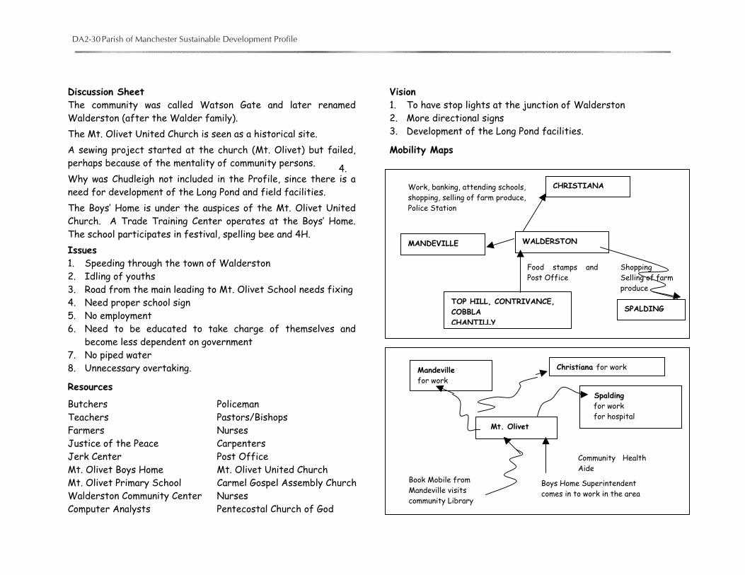
COMMUNITY: WALDERSTON (February 2002) Timeline Date History 1800s Mt. Olivet Presbyterian, Chantilly Anglican and Mizpah Moravian Churches founded 1838 Lands owned by the Herons. They sold some after slavery was abolished to a German family named Walder. Most of the land was stony. 1920s School Inspectors, including a Mr. Virtue, used to go around to all the schools in JA 1930s Roads and electricity came through the area Horse-drawn buggy was a popular form of transportation Persons bought land from the herons for £1 per acre Fevergrass used for fever, Sarsparilla for tonic Bananas grown on a large scale and sold to persons at Kendal Rice & Peas, Cowfoot, Pork and Beef were the famous dishes;
Salting was done to preserve meat and fish White lime and dirt were used for building construction. Cedarwood roof shingles were popular. Roofs were made with a hip shape. Chappy Lord was the first man to get electricity 1933 A hurricane destroyed trees and roofs 1939 Persons from this area went to fight World War II. Mr. Virtue joined the Royal Air Force (RAF) Farm products were sold to the markets were sold to the Marketing Department at Walderston. Persons from as far afield as St.
Elizabeth came to buy products at this market. The Americans in Sandy Gully also supported this market. Battery-operated radios were used Someone got electrocuted near Christiana 1940s More persons were recruited for World War II to farm in the United States 1945 The Market ended 1951 Hurricane Charlie. Roofs were lost 1960 Road opened, since then accidents keep happening 1962 Currency changed to dollars and cents 1969 Mt. Olivet School removed from church to its present location 1980 No piped water in homes 1998 Water storage tank built at Mt. Olivet School
DA2-30 Parish of Manchester Sustainable Development Profile
Discussion Sheet The community was called Watson Gate and later renamed Walderston (after the Walder family). The Mt. Olivet United Church is seen as a historical site. A sewing project started at the church (Mt. Olivet) but failed, perhaps because of the mentality of community persons. Why was Chudleigh not included in the Profile, since there is a need for development of the Long Pond and field facilities. The Boys’ Home is under the auspices of the Mt. Olivet United Church. A Trade Training Center operates at the Boys’ Home. The school participates in festival, spelling bee and 4H. Issues 1. Speeding through the town of Walderston 2. Idling of youths 3. Road from the main leading to Mt. Olivet School needs fixing 4. Need proper school sign 5. No employment 6. Need to be educated to take charge of themselves and
become less dependent on government 7. No piped water 8. Unnecessary overtaking.
Resources
Vision 1. To have stop lights at the junction of Walderston 2. More directional signs 3. Development of the Long Pond facilities.
Mobility Maps
4.
Butchers Policeman Teachers Pastors/Bishops Farmers Nurses Justice of the Peace Carpenters Jerk Center Post Office Mt. Olivet Boys Home Mt. Olivet United Church Mt. Olivet Primary School Carmel Gospel Assembly Church Walderston Community Center Nurses Computer Analysts Pentecostal Church of God
Mt. Olivet
Boys Home Superintendent comes in to work in the area
Community HealthAide
Book Mobile from Mandeville visits community Library
Mandeville for work
Christiana for work
Spalding for work for hospital
WALDERSTON
TOP HILL, CONTRIVANCE, COBBLA CHANTILLY
Food stamps andPost Office
Shopping Selling of farm produce
MANDEVILLE
CHRISTIANA Work, banking, attending schools, shopping, selling of farm produce, Police Station
SPALDING

Development Area Profiles: Christiana DA2-31
COMMUNITY: CHRISTIANA DISTRICT: BROCKERY
Social Issues Need for community centre and a playfield Need for a Community Based Organization More street lights
Garbage disposal A fire hydrant is needed in the housing scheme Need churches Road leading from the Old Housing Scheme is bad Unemployment, especially among school leavers who do not
have a vocational skill
Discussion Sheet 1. When rain falls some drains are blocked up causing serious
washing away of the road structure and damaging property. About 10 persons’ property has been damaged (i.e. farms, driveways, etc.)
2. Proper garbage disposal has not been carried out in this community. This has been a problem for the past 2 years. Contacts were made to the Southern Parks and Market (S.P.M) in 2001 for the collection of garbage in this area. a. In 2002 garbage is only collected in the New Housing
Scheme. b. Some persons take their garbage to Christiana and throw
it into the receptacle at a cost. c. Others burn or dump their garbage in the Brockery River 3. Due to improper practice of garbage disposal, there is an
increase in mosquitoes and rats; the pest control department had to be called in.
4. The cost of transportation is too high; persons pay $150 and over from Christiana to Brockery.
5. Vegetables do well as the soil type is clay (said to be strong to hold farm produce). Yams are grown on a small scale.
6. Persons do farming as another means of livelihood, however, sales are very slow.
Spalding Use of the Hospital, Library, schools, Police Station
Top Hill Alternative route to Mandeville
Walderston Regular route to get to Christiana, Spalding and Mandeville
Christiana Use of Library, Police Station, schools, banks, entertainment
Mizpah Clinic
Mandeville Shopping Attending school
Contrivance

DA2-32 Parish of Manchester Sustainable Development Profile
7. Persons have to travel to Christiana to attend churches since there are no churches in Brockery, as a result some persons are only able to go once per month.
8. It is felt that if a CBO is formed in the community, issues could be discussed and dealt with more effectively.
9. About ten (10) students in Brockery are school drop-outs—a result of parental neglect or the financial difficulties.
Resources The Water Falls at Dunco River — the river can be used for
bathing but needs cleaning and a drive in- entrance Farmers Teachers Pastor Community Health Aide Nurses and Practical Nurses Dental Nurses Drivers (taxi & truck) Clerk (sales & office) Cabinet Makers Masons, Plumbers Electricians, Welders Mechanics Hairdressers Police & Firemen Small Business Operators
Visions A playfield A community centre A Community Based Organization Churches A cottage industry or bi-product factory
DISTRICT—BRONTIE Social Issues Road need repairs More household telephone Drainage needs cleaning and repairs
Lack of employment Praedial larceny, stealing of cattle, ground provision Soil erosion
Discussion Sheet 1. Since about 1980 there has been a decline in agricultural
activities in Brontie. 2. Some persons who did farming are now retired persons or
pensioners. 3. JAS group has no impact on community, RADA just a little. 4. Persons use bushes near the Apostolic Faith Church as toilet.
DISTRICT—MOLLISON Social Issues Bad Roads Unemployment (for all ages) Health centre needs repair Difficulty selling farming produce
Discussion Sheet 1. Major crops; Irish potatoes, yams, carrots, tomato, lettuce. 2. The community members feel that there is a need for some
form of consultation with manufacturing companies such as Grace, Eve, and the local supermarket to discuss ways and means of using their produce. In essence they want to find out why farmers are not benefiting for these companies.
DISTRICT -- CHRISTIANA TOWN CENTRE Social Issues Need more parking areas for buses, taxis, private vehicles. Need for road project to be completed (i.e., money was
granted in 2001 to do the road from the market to Mollison in 2001; only a fraction was done.) Mr. Green will follow up.
Development Area Profiles: Christiana DA2-33
Bus and taxi operators’ stops in the road to collect and let off passengers, this causes a lot of traffic problems. Need for a bypass route to help- reduce congestion of motor
vehicle and pedestrian traffic. Sometimes it takes up to 3 hrs. to get from Apple Tree Plaza to the Police station, this distance can be covered in less than 5 minutes when the is not congestion, especially on weekends. Poor garbage collection Need piped water to other areas in Christiana (N.E. areas).
Problem Analysis Poor garbage collection
Causes: No monitoring of collection by those paid to do this. Effects: 1. Burning of garbage in districts
2. Indiscriminate dumping of garbage, dead animals. Suggestion: S.P.M. to monitor process.
Traffic congestion Causes: Improper parking is a major cause of congestion Solution: To have a relief road in front of Apple Tree Plaza,
community centre and Never Mind Road.
Economic Base 1. Super Plus Supermarket—major place of employment 2. Super Plus Shopping Centre 3. Pantry Supermarket 4. George Kirby Hardware 5. Shell Gas Station 6. Nova Scotia Bank 7. Ken Shelas Fry chicken Restaurant 8. Tasty Treat Pastry and Restaurant 9. Juicy Patties
10. Market 11. McDonalds Restaurant—Mobile 12. Syldillion Court 13. Other restaurants, shops and bars 14. Shaw’s Hardware 15. Sinclair Bargain Centre 16. National Commercial bank 17. Villa Bella Hotel 18. Greens Plaza
Vision A bypass road for the Town of Christiana More parking areas to access business areas Good roads for all the areas in Christiana Development Area More job opportunities for youths Skill training centre Need to have a proper collection system.
COMMUNITY: PIKE DISTRICT -- PIKE PROPER Social Issues Telephone (house to house) Need a JAMAL school Improve housing conditions for the shut-ins Proper fencing for the Basic School* A sports complex* Caution signs Skills training centre Improve centre facilities Improve road surfaces
DA2-34 Parish of Manchester Sustainable Development Profile
Need piped water (no truck supplies this area with water only health centre at Carter
More street lights * Being followed up by JSIF Re: property title (2002).
DISTRICT: NEW ROAD Issues Need for electricity Need for telephone Need for road construction or repair About eight years ago persons from New Road cut the road
by hand. Councilor Gentles provided machinery to assist but this only worked for a day due the opposition party.
In 2000 persons assessed the district’s electricity needs and assured service. Nothing has happened.
New Road is a farming district. 75% of the land-space is used for farming. Crops include; yams, banana, Irish potatoes, carrots and cabbages. Mangoes only bear every five years.
Yams are sold to higglers, local markets or Kingston exporters.
Observation 1. 60% of the farmers in Pike are young – under 30 years old. 2. Types of soil in Pike: Clay on the east; Red dirt on the west.
Resources Hector’s River Spring Radar Air Traffic Control Centre Schools Shops Churches Garage (body work, mechanic).
Pike Timeline
Dates History 1950s Pike SDA started at the home of Mr. Cynis Powell, which was about 10 chains off the main road. 1955 The SDA church got a piece of land near the main and started constructing the building with the help of Pastor W. Reid who was in charge. 1957 The SDA church was completed, since then every four years there has been a change of pastors 1960 Pike United Church formerly Presbyterian was founded by the newly born again Christians. It was an old wooden structure. __ United
Church was governed by an English Min. Rev. W.W. Hardie from Ireland. 1968 The church building was re-modeled. The church was amalgamated into the United Church in Jamaica, and the Grand Cayman Church at that
time was daughter to Lowe River Charge and sister to Cascade Charge. 1970 The church was joined to the Bryce United which is now the mother church along with Robin’s Hall sister church. 1980 The Radar Centre at Denham Road was built by the Irish government approximately 150ft. 1992 Further reformation re-named the church as the United Church in Jamaica and the Cayman Islands. 1994 The first well attended P.T.A. was held when 54 parents and teachers met. The goals, aims, aspirations of the group were outlined. 1996 —An out reach programme was established; needed persons were treated by the school.
—Parents participated in the beautification of the school compound. —Parents started sharing in devotional and patriotic celebrations.
1999 The Radar centre was re-modeled by the Canadian Government to ensure that the centre would be Y2K compliant, and now stands approximately 100ft. tall.