1 kavaya – lidar wg status of laser/lidar working group requirements by michael j. kavaya nasa...
TRANSCRIPT

1
Kavaya – Lidar WG
Status of Laser/Lidar Working Group Requirements
by
Michael J. KavayaNASA Langley Research Center
Bruce M. GentryNASA Goddard Space Flight Center
to
Working Group on Space-Based Lidar WindsJune 27-30, 2006
Welches, OR

2
Kavaya – Lidar WG
Atmospheric Dynamics (Winds)
Science Requirements Subgroup
Michael J. Kavaya (S), NASA/LaRCBruce M. Gentry (T), NASA/GSFCRobert Atlas, NOAA/AOMLRenny A. Fields, Aerospace Corp.Karen Moe, ESTOGeary K. Schwemmer, NASA/GSFCUpendra N. Singh, NASA/LaRCGary D. Spiers, NASA/JPL
(S) = Science lead (T) = Technology lead
Authors also worked in Technology Challenge subgroups:• Laser Transmitters• Detection, Processing, Optics
3
Kavaya – Lidar WG
NASA Laser/Lidar Technology Requirements Working Group
• First WG meeting: Nov. 8-9, 2005• Second WG meeting: Dec. 14-15, 2005• Community Forum: Jan. 10, 2006• Third WG meeting: Jan. 11, 2006• Fourth WG meeting: Feb. 7-8, 2006• Writing of final report … • June 9, 2006: draft copy of final report available at
http://esto.nasa.gov/lwg/lwg.htm

4
Kavaya – Lidar WG
Space Wind Measurement Requirements - 1Demo Threshold Objective
Vertical depth of regard (DOR) 0-20 0-20 0-30 km
Vertical resolution: Tropopause to top of DOR Top of BL to tropopause (~12 km) Surface to top of BL (~2 km)
Not Req.21
Not Req.1
0.5
20.5
0.25
kmkmkm
Number of collocated LOS wind measurements for horizA wind calculation
2 = pair 2 = pair 2 = pair -
Horizontal resolutionA 350 350 100 km
Number of horizontalA wind tracksB 2 4 12 -
Velocity errorC Above BL In BL
32
32
21
m/sm/s
Minimum wind measurement success rate 50 50 50 %
Temporal resolution (N/A for single S/C) N/A 12 6 hours
Data product latency N/A 2.75 2.75 hours
A – Horizontal winds are not actually calculated; rather two LOS winds with appropriate angle spacing and collocation are measured for an “effective” horizontal wind measurement. The two LOS winds are reported to the user.
B – The cross-track measurements do not have to occur at the same along-track coordinate; staggering is OK.C – Error = 1 LOS wind random error, projected to a horizontal plane; from all lidar, geometry, pointing, atmosphere, signal processing, and
sampling effects. The true wind is defined as the linear average, over a 100 x 100 km box (or 175 km or 25 km) box centered on the LOS wind location, of the true 3-D wind projected onto the lidar beam direction provided with the data.
(original errata that have been corrected) (Added/clarified requirements during NASA ESTO ESTIPS Laser/Lidar Working Group)

5
Kavaya – Lidar WG
Space Wind Measurement Requirements - 2
Demo Threshold Objective
Vertical location accuracy of LOS wind measurements 1 0.1 0.1 km
Horizontal location accuracy of LOS wind measurements 5 0.5 0.5 km
Allowed angular separation of LOS wind pair, projected to a horizontal plane 30-150 30-150 30-150 degree
Maximum allowed horizontal separation of LOS wind pair 50 35 35 km
Maximum horizontal extent of each horizontalA wind meas. 175 100 25 km
Minimum horizontal cross-track width of regard of wind measurements 400 km
Maximum cross-track spacing of adjacent cross-track locations N/A 350 100 km
Maximum design horizontal wind speed: Above BL Within BL
5050
7550
10050
m/sm/s
Design 1 wind turbulence level: Above BL Within BL
11
1.21
1.41
m/s
Max. LOS wind unknown bias error, proj. to a horiz. plane 1 0.1 0.05 m/s
Minimum design a priori velocity knowledge window, projected to a horizontal plane (using nearby wind measurements and contextual information)
26.6 26.6 26.6 m/s
Design cloud field: Layer from 9-10 km, extinction coefficient Layer from 2-3 km, 50% of lidar shots untouched, 50% blocked
0.1450, random
0.1450, random
0.1450, random
km-1
%
Aerosol backscatter coeff.: 2 vertical profiles provided Provided Provided Provided m-1sr-1
Aerosol backscatter: Probability density function (PDF) PDF width
LognormalProvided
LognormalProvided
LognormalProvided
m srm-1sr-1
Atmospheric extinction coefficient: 2 vertical profiles provided Provided Provided Provided km-1
Orbit latitude coverage N/A 80N to 80S 80N to 80S Degree
Downlinked data All All TBD -
(original errata that have been corrected) (Added/clarified requirements during NASA ESTO ESTIPS Laser/Lidar Working Group)

6
Kavaya – Lidar WG
Atmospheric Winds
Recommended Roadmap
Past
1 Micron Altimetry
2 Micron Winds
0.355 & 2 Micron Winds
0.355 & 2 Micron WindsSpace-like Geometry & Scanning
0.355 & 2 Micron WindsNPOESS833 kmDemo
0.355 & 2 Micron WindsNASA400 km
Threshold, 3 yr.
Œ
Ž

7
Kavaya – Lidar WG
June 15, June 15, 20062006
NASA ESTO Laser/Lidar Working Group Report
Azita Valinia, Ph.D.Working Group Chair

8
Kavaya – Lidar WG
Acknowledgements
Editors:
Jon Neff (The Aerospace Corporation)Azita Valinia (NASA/GSFC- WKG Chair)
Authors:
Jason Hyon (NASA/JPL)Samuel Gasster (The Aerospace Corporation)Jon Neff (The Aerospace Corporation)April Gillam (The Aerospace Corporation)Karen Moe (NASA/ESTO)Dave Tratt (NASA/JPL)Azita Valinia (NASA/GSFC- WKG Chair)
Production Editor:
Philip Larkin (GST)
Contributors:
Waleed Abdalati (NASA/GSFC)Robert Atlas (NOAA)Bryan Blair (NASA/GSFC)Rebecca Castano (NASA/JPL)Joe Coughlin (NASA/ARC)Paul DiGiacomo (NASA/JPL)Ralph Dubayah (University of Maryland)Renny Fields (The Aerospace Corporation)William Folkner (NASA/JPL)Bruce Gentry (NASA/GSFC)Bill Heaps (NASA/GSFC)Michelle Hofton (University of Maryland)Syed Ismail (NASA/LaRC)S. B. Luthcke (NASA/GSFC)Mike Seablom (NASA/GSFC)Michael Kavaya (NASA/LaRC)Upendra Singh (NASA/LaRC)Benjamin Smith (NASA/JPL)Gary Spiers (NASA/JPL)Bill Stabnow (NASA/ESTO)Mark Vaughn (NASA/LaRC)

9
Kavaya – Lidar WG
Outline
• Definition Process
• Investment Priority Analysis
• Technology Roadmap
Measurement ScenariosMeasurement Scenarios
Technology ChallengesTechnology Challenges
LaserTransmitter
LaserTransmitter
DataAcquisition
DataAcquisition
Capability BreakdownStructure (CBS)
Capability BreakdownStructure (CBS)
Final ReportFinal Report
RoadmapRoadmap
AtmosphericCompositionAtmosphericComposition
AtmosphericDynamics
AtmosphericDynamics
Topography (Land, Ice, Biomass)
& OceansTopography (Land, Ice, Biomass)
& Oceans
Detection,Processing, Optics
Detection,Processing, Optics
DataUtilization
DataUtilization
Science RequirementsScience RequirementsPhase A:Science
Phase B:Technology
Phase C:Integration
0
2
4
6
8
1 0
1 2
1 4
1 6
1 8
E n a b l i n g C o s t R e d u c i n g P e r f o r m a n c e
E n h a n c i n g
T e c h n o l o g y R e q u i r e m e n t T y p e

10
Kavaya – Lidar WG
Working Group Charter
Develop a strategy for targeted technology development and risk mitigation efforts at NASA by leveraging technological advancement made by other government agencies, industry and academia, and move NASA into the next logical era of laser remote sensing by enabling critical Earth Science measurements from space.

11
Kavaya – Lidar WG
Requirement Definition Process
Measurement Scenarios
Measurement Scenarios
Technology ChallengesTechnology Challenges
Laser Transmitter
Laser Transmitter
Data Acquisition
Data Acquisition
Capability Breakdown
Structure (CBS)
Capability Breakdown
Structure (CBS)
RoadmapRoadmap
Atmospheric CompositionAtmospheric Composition
Atmospheric Dynamics
Atmospheric Dynamics
Topography (Land, Ice, Biomass) & OceansTopography (Land,
Ice, Biomass) & Oceans
Detection, Processing,
Optics
Detection, Processing,
Optics
Data Utilization
Data Utilization
Science RequirementsScience Requirements Phase A:
Science
Phase B: Technolog
y
Phase C: Integrat
ion
Prioritization Prioritization FilterFilter
12
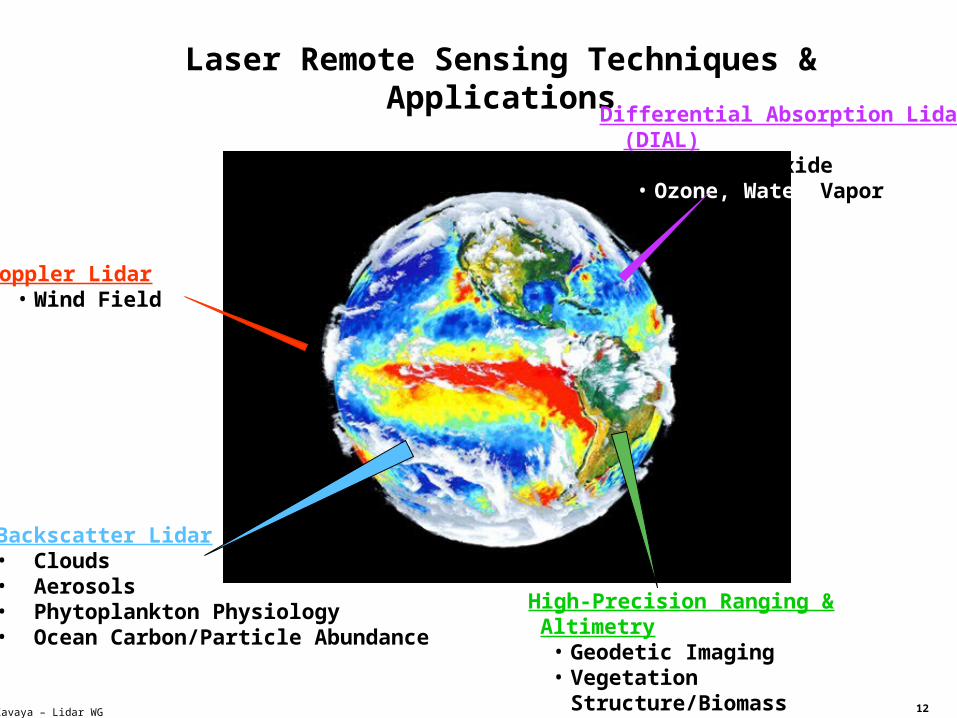
Kavaya – Lidar WG
Laser Remote Sensing Techniques & Applications
Doppler Lidar• Wind Field
High-Precision Ranging & Altimetry• Geodetic Imaging• Vegetation Structure/Biomass• Earth Gravity Field
Backscatter Lidar• Clouds • Aerosols• Phytoplankton Physiology• Ocean Carbon/Particle Abundance
Differential Absorption Lidar (DIAL)• Carbon Dioxide • Ozone, Water Vapor
13
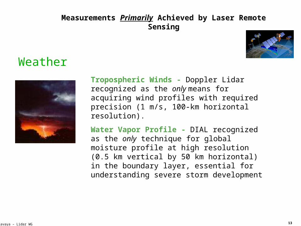
Kavaya – Lidar WG
Tropospheric Winds - Doppler Lidar recognized as the only means for acquiring wind profiles with required precision (1 m/s, 100-km horizontal resolution).
Water Vapor Profile - DIAL recognized as the only technique for global moisture profile at high resolution (0.5 km vertical by 50 km horizontal) in the boundary layer, essential for understanding severe storm development
Weather
Measurements Primarily Achieved by Laser Remote Sensing
14
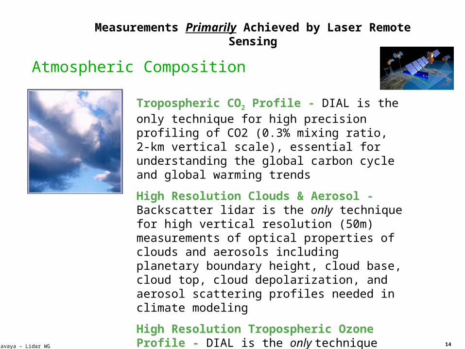
Kavaya – Lidar WG
Tropospheric CO2 Profile - DIAL is the only technique for high precision profiling of CO2 (0.3% mixing ratio, 2-km vertical scale), essential for understanding the global carbon cycle and global warming trends
High Resolution Clouds & Aerosol - Backscatter lidar is the only technique for high vertical resolution (50m) measurements of optical properties of clouds and aerosols including planetary boundary height, cloud base, cloud top, cloud depolarization, and aerosol scattering profiles needed in climate modeling
High Resolution Tropospheric Ozone Profile - DIAL is the only technique for global tropospheric ozone profiling with high resolution (1-2 km vertical, 100 km horizontal), essential for understanding atmospheric processes in the troposphere
Measurements Primarily Achieved by Laser Remote Sensing
Atmospheric Composition

15
Kavaya – Lidar WG
3D Biomass- Lidar Altimetry is the only technique for profiling 3D vegetation canopies to the required vertical accuracy of 0.5 m and horizontal resolution of 5-20m
Phtoplankton Physiology & Ocean Carbon Abundance - Lidar is the only method for measuring particle profiles in the oceans’ mixed layer of 5m resolution depth or better, necessary to understand how oceanic carbon storage and fluxes contribute to the global carbon cycle
Measurements Primarily Achieved by Laser Remote Sensing
Carbon Cycle & Ecosystems

16
Kavaya – Lidar WG
High Resolution Ice Surface Topography - Lidar Altimetry is the only technique for profiling ice surface topography and changes of less than 1 cm/year, essential for understanding climate change
Measurements Primarily Achieved by Laser Remote Sensing
Climate Variability and Change

17
Kavaya – Lidar WG
Earth Gravity Field 3D - Improved range measurements provided by laser interferometry will improve Earth gravity field observation to less than 100 km and 10-day resolution with an accuracy of less than 1cm equivalent surface water height
Terrestrial Reference Frame - Improved satellite laser ranging network will provide a factor of 5-10 improvement in reference frame and satellite precision orbit determination over current measurements
Measurements Primarily Achieved by Laser Remote Sensing
Earth Surface and Interior
18
Kavaya – Lidar WG
Outline
• Definition Process
• Investment Priority Analysis
• Prioritization Criteria
• Analysis
• Technology Roadmap
0
2
4
6
8
1 0
1 2
1 4
1 6
1 8
E n a b l i n g C o s t R e d u c i n g P e r f o r m a n c e
E n h a n c i n g
T e c h n o l o g y R e q u i r e m e n t T y p e
19
Kavaya – Lidar WG
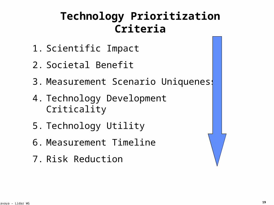
Technology Prioritization Criteria
1. Scientific Impact
2. Societal Benefit
3. Measurement Scenario Uniqueness
4. Technology Development Criticality
5. Technology Utility
6. Measurement Timeline
7. Risk Reduction

20
Kavaya – Lidar WG
Scientific Impact
The degree to which the proposed measurement via lidar technique will impact our understanding of the Earth System and will help answer the overarching questions defined in NASA Earth Science Research strategy.
Tropospheric Winds --> Severe Weather Prediction
Tropospheric CO2 Profile --> Global Warming Trends and Air Quality
High Resolution Polar Ice Topography Change --> Climate Change Prediction
3D Biomass --> Carbon Cycle, Sources/Sink, Climate Change Prediction
Phytoplankton Physiology --> Oceanic Carbon Cyle
Impact Timeline

21
Kavaya – Lidar WG
Societal Benefit
The degree to which the proposed measurement has the potential to improve life on Earth.
1. Severe Weather Prediction (Trop Wind)
2. Air Quality/Assessment of Global Warming (CO2)
3. Long Term Climate Change (Ice mass, Biomass, CO2)
Near- Term Benefits
Long-Term
Benefits
Credit: Ardizzone &Terry 2006
Prediction of Hurricane Tracks Using Trop Wind
Data
Nature
Control Run Track
Improved Track Using Lidar Winds

22
Kavaya – Lidar WG
Measurement Scenario Uniqueness
Whether Lidar technique is the primary or unique technique for making the proposed measurement.
• Tropospheric Winds
• CO2 Vertical Profile
• Vegetation Biomass
• High Resolution Ice Surface Topography
• Phytoplankton Physiology & Functional Groups
• High Spectral Resolution Aerosol
• Ocean Carbon/Particle Abundance
• Earth Gravity Field
• Terrestrial Reference Frame
Also appeared under previous criteria

23
Kavaya – Lidar WG
Technology Development Criticality
Whether the development of the proposed technology enables new and critical measurement capabilities as opposed to provide incremental improvement in the measurement.
Enabling
Cost Reducing
Performance Enhancing
Technology Criticality Priority
24
Kavaya – Lidar WG
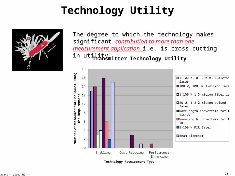
Technology Utility
The degree to which the technology makes significant contribution to more than one measurement application, i.e. is cross cutting in utility.
0
2
4
6
8
10
12
14
16
18
Enabling Cost Reducing PerformanceEnhancing
Technology Requirement Type
1-100 W, 0.1-50 mJ 1-micronlaser
100 W, 100 Hz 1-micron laser
1-100 W 1.5-micron fiber laser
20 W, 1 J 2-micron pulsedlaser
Wavelength converters for thevis-UV
Wavelength converters for theIR
5-100 W MIR laser
Beam director
•High Spectral Resolution AerosolTransmitter Technology Utility

25
Kavaya – Lidar WG
Measurement Timeline
Determined by the time horizon when a particular measurement is needed, as articulated in NASA’s Earth Science Research Strategy.

26
Kavaya – Lidar WG
Risk Reduction
The degree to which the new technology mitigates the risk of mission failure.
• Laser Transmitters present the greatest development challenge and pose the greatest risk.
• Risk reduction laser transmitter technologies are of highest priority.

27
Kavaya – Lidar WG
Filtering Requirements Leads to Technology Priorities
Science Applications
Enabling Technologies
Priority Filter
Science Impact
Societal Benefit
Scenario Uniqueness
Technology Criticality
Technology Utility
Timeline
Risk Reduction
Tropospheric Winds
Ice Topography
Tropospheric CO2
Phytoplankton Physiology
3D Biomass
Laser Transmitter
s
Detection, Processing,
Optics
Data Acquisition
& UtilizationEmerging
Technology
Priorities

28
Kavaya – Lidar WG
Required Laser Transmitter Capabilities
Beam DirectorVis-UVWavelengthConverters
CW Lasers
5 W 10 WFiber
Ice Mass, Biomass
Pul
se R
epet
ition
Fre
quen
cy (
Hz)
Energy Per Pulse (mJ)
1. Pulsed Lasers
1 micron 1.5 micron 2 micronWavelength:
Fiber Domain
Fiber or Bulk Material
BulkMaterial Domain
BiomassIce Mass
Phyto-
plankton
CO2
Tropospheric
Winds
2. CW Lasers

29
Kavaya – Lidar WG
COCO22
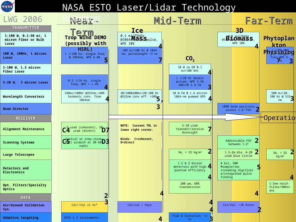
NASA STO Laser/Lidar Technology Roadmap
Trop Wind DEMO
Ice Mass CO2
3D Biomass
Laser Transmitter Priorities
1-100 W, 0.1-50 mJ, 1 micron Fiber or Bulk Laser
0.1 mJ/75kHz @1064nm, 5ns pulse, WPE 10%
0.1 mJ/75kHz @1064nm, 5ns pulse,
WPE 10%
100 W, 100Hz, 1 micron Laser
1 J/100 Hz, single freq @ 1064nm, WPE 6-8%
100 mJ/100 Hz @ 1064 nm, pulselength ~3 ns
1 J/20-100 Hz, single freq WPE 6-8%
1-100 W, 1.5 micron Fiber Laser
10 W cw OR 0.1 mJ/100 kHz
5-20 W, 2 micron Laser
0.5 J/10 Hz, single freq, WPE > 1.4%
1 J/20 Hz double pulsed, WPE 3-5% AND/OR 5 W CW
Wavelength Converters
340mJ/100Hz @355nm,>40% harmonic
conv. from 1064nm
20/100&500mJ/20-100 Hz @532nm conv eff. >50%
10 W CW @ 1.6 micron 1064-nm pumped OPO
500 mJ/20-100 Hz @ 532
nm
Beam Director1000 beam positions
across 1-2o FOV
Phyto-
plankton
5
4
4
4
5,3
4
2
3
3
4
4
7
3
* Current TRL designated in lower * Current TRL designated in lower right corner.right corner.

30
Kavaya – Lidar WG
Required Lidar Receiver Capabilities
ScanningSystems
1.5 micron
2 micron
Wavelength:
Detection Electronic
s
Transmit/Receive Alignment (µrad)
2 4 6 8 10
Alignment Maintenance
Aperture Diameter (m)
1 2 3
Large Telescopes< 25 kg/m2
Specialty Optics
SpectralAnalyzers
Qua
ntu
m E
ffic
ienc
y (%
)20
4060
8010
010
Detectors
OpticalFilters
Tropospheric
Winds
Ice MassBiomass
Phyto-
plankton
CO2

31
Kavaya – Lidar WG
Alignment Maintenance5 rad (coherent), 50 rad
(direct)
5-10 rad transmit/receive
boresight
Scanning SystemsConical or step-stare, full azimuth at 30-50o, nadir
Addressable FOV between 1-2o
Large Telescopes3m, < 25 kg/m2 1.5-2m dia, 4-20 rad
blur circle3m, < 25
kg/m2
Detectors and Electronics
1.5 & 2 micron detectors with high quantum efficiency
8 bit, 500 Msample/sec streaming digitizer w/integrated pulse finding
Opt. Filters/Specialty Optics
200 pm, 60% transmission
1-3nm notch filter/90%trans
D7C4
D3C5
4
2
2
5
2
4
7
2
4
Lidar Receiver Priorities
COCO
22
Trop Wind DEMO
Ice Mass CO2
3D Biomass
Phyto-
plankton
* Current TRL designated in lower * Current TRL designated in lower right corner.right corner.

32
Kavaya – Lidar WG
Air/Ground Validation Sys.
Cal//Val ≤1 hr* Cal/val < Days Cal/Val: <1% Error
Adaptive targeting OSSE ≥ 3 instruments Plan & Execution: <3 hr
Intelligent Sensor H&SLaser life diagnosis < days
Laser life prognosis < days
On-board Sensor ControlRT Event detection
(clouds)Control sys. error =
4rad
34
3
44
44 2
2
*Required for operational weather and air pollution measurement systems
COCO
22
Trop Wind DEMO
Ice Mass CO2
3D Biomass
Phyto-
plankton
Data Acquisition and Utilization Priorities
* Current TRL designated in lower * Current TRL designated in lower right corner.right corner.

33
Kavaya – Lidar WG
Outline
• Definition Process
• Investment Priority Analysis
• Technology Roadmap
34
Kavaya – Lidar WG
Trop Wind DEMO
Ice Mass
CO2
3D biomass
Phytoplankton
physiology
TRANSMITTERTRANSMITTER
1-100 W, 0.1-50 mJ, 1 micron Fiber or Bulk Laser
0.1 mJ/75kHz @1064nm, 5ns pulse, WPE 10%
0.1 mJ/75kHz @1064nm, 5ns pulse, WPE 10%
100 W, 100Hz, 1 micron Laser
1 J/100 Hz, single freq @ 1064nm, WPE 6-8%
100 mJ/100 Hz @ 1064 nm, pulselength ~3 ns
1 J/20-100 Hz, single freq WPE
6-8%
1-100 W, 1.5 micron Fiber Laser
10 W cw OR 0.1 mJ/100 kHz
5-20 W, 2 micron Laser0.5 J/10 Hz, single freq, WPE >
1.4%
1 J/20 Hz double pulsed, WPE 3-5% AND/OR 5 W
CW
Wavelength Converters340mJ/100Hz @355nm,>40% harmonic conv. from 1064nm
20/100&500mJ/20-100 Hz @532nm conv eff. >50%
10 W CW @ 1.6 micron 1064-nm pumped OPO
500 mJ/20-100 Hz @ 532 nm
Beam Director1000 beam positions across
1-2o FOV
RECEIVERRECEIVER
Alignment Maintenance5 rad (coherent), 50 rad
(direct)NOTE: Current TRL in
lower right corner.5-10 rad transmit/receive
boresight
Scanning SystemsConical or step-stare, full azimuth at 30-50o, nadir
Winds: C=coherent, D=direct
Addressable FOV between 1-2o
Large Telescopes3m, < 25 kg/m2 1.5-2m dia, 4-20 rad blur
circle 3m, < 25 kg/m2
Detectors and Electronics1.5 & 2 micron detectors
with high quantum efficiency8 bit, 500 Msample/sec streaming digitizer w/integrated pulse finding
Opt. Filters/Specialty Optics200 pm, 60% transmission 1-3nm notch
filter/90%trans
DATADATA
Air/Ground Validation Sys. Cal//Val ≤1 hr* Cal/val < Days Cal/Val: <1% Error
Adaptive targeting OSSE ≥ 3 instruments Plan & Execution: <3 hr
Intelligent Sensor H&S * Required for operational Laser life diagnosis < days Laser life prognosis < days
On-board Sensor Control weather and air pollution RT Event detection (clouds) Control sys. error = 4rad
Trop Wind DEMO Trop Wind DEMO (possibly with (possibly with
HSRL)HSRL)
Ice Ice MassMass
COCO22
3D 3D BiomassBiomass PhytoplanPhytoplan
kton kton PhysiologPhysiolog
yy
Near-Near-TermTerm
Mid-TermMid-Term Far-TermFar-Term
5
4
4
D7C4
D3C5
LWG 2006NASA ESTO Laser/Lidar Technology Roadmap
4
5,3
4
4
2
2
2
3
3
4
34
3
442
4
44 2
5
2
4
7
3
7
2
4
Operation
35
Kavaya – Lidar WG
Overall Recommendation
• Highest priority measurement(s) must be identified at the Agency level first.
• Technology Requirements for each measurement in the area of transmitters, DPO, and DADU are tightly coupled.
• Technology development to satisfy the priority measurement(s) must then targeted and coordinated in the three categories in order to get maximum return on investment.

36
Kavaya – Lidar WG
Kavaya/Gentry Conclusions
• Fast-paced experience• Impossible to AND {include everyone who has something to
contribute, afford the effort, come to an agreement, finish}; therefore accept the imperfections of it all
• Draft report strongly endorses technology development for tropospheric wind mission
• Tall poles not explicitly captured: coherent winds = laser lifetime, alignment; direct winds = scanner, photon efficiency
• Still time to (quickly) give corrections to draft report• Future NASA opportunities for funding might reflect the priorities of
this report• Many thanks to Ramesh Kakar for participating & advocating• Many thanks to Winds WG members who contributed