1 january/april zoos - kankakee valley historical … river...history* and the fur trade in...
TRANSCRIPT

friends of the Chicago Portage National Historic Site Newsletter & GuideVol. 9 No. 1 January/April ZOOS
© Philip E. Vierling 2008
Serving those interested in the Chicago Portage National Historic Site, early Chicago history* and the fur trade in Illinois* Privately published every four months with nonprofit distribution.
KANKAKEE MARSH PLACE-NAMES
On page 181 of The Autobiography of Gurdon Saltonstall Hubbard, there is the following sentence near the bottom of the pages
"I had a small outfit up the Kankakee River 9 about six or eight miles from where 'Hubbard f s Trail 1 crossed the Kankakee? where two men were located."
Hubbard 1 s Trail crossed the Kankakee River at the "Upper Crossing 9 * located about one-mile east of Momence, Illinois, at about the west section line of Section 17, T-31-N, R-14-E, on the Momence Quadrangle. A point located six miles due east from the Upper Crossing is exactly on the Illinois/Indiana state line, A point located eight miles due east of the Upper Crossing is at the true mouth of the former Beaver Lake's outlet stream, now known as the "Beaver Lake Ditch." The present, existing ditch has its mouth about 2100 feet farther east. Hubbard's Bunkum trading post gathered most of Its furs from the area at the south end of Beaver Lake. Beaver Lake f s outlet stream flowed north to the Kankakee River, so a fur depot at the north end of the lake probably made good business sence.
T-C: 9 however, the six or eight mile distances mentioned in Hubbard's book were in an upstream direction, then the end points would bes (a) For the six-mile distance, at the center of the north section line of Section 24, T-31-N, R-15-E, at the east limits of the "Garden of Eden" In Illinois. Or, (b) for the eight-mile distance, at a location about 1500 feet west of the state line. Since there is nothing sigrxificent at either of these locations, it is concluded that Hubbard's measure of six or eight miles from the Upper Crossing is in a due east direction.
Although the mouth of Beaver Lake's outlet stream may be a logical location of Hubbard's fur depot, the issue of the depot's location is confounded by a sentence on page 335 in Part I of Beckwith's History of Iroquois County;
"Besides the post at Bunkum, he (Hubbard) had one on the Kankakee, ten miles above the state line, one on the Embarrass, another on the head waters of the Little Wabash, and two others still farther south."
As per such, Burt E, Burroughs, in his book, Tales of an Old Border Town and Along the Kankakee, page 89, gives the following location of the fur depot:
"Gurdon S. Hubbard had a fur depot at Blue Grass for years, and at such times when the season's pack was transported to Chicago by way of the Hubbard Trail, his men brought their furs from Blue Grass down the river as far as the famous 'Upper Crossing, 1 one mile above the present city of Momence, and there turned them over to the wilderness cavalcade bound for Chicago."
Blue Grass is a point on the Kankakee River located about 6% miles due east of the Illinois-
- 1 -

Indiana state line, or about ten miles upriver from the state line before channelizationA road, on the south side of the river, leading north from Indiana Highway 10 is named the "Blue Grass Road,/* The landing here is at the mouth of a small, un-named tributary stream. Could this be the location of Hubbard f s fur depot? Perhaps. But, Fay Folsom Nichols, the author of The Kankakee, Chronicle of an Indiana River and Its Fabled Marshes (Theo. Gaus 8 Sons, Inc., Brooklyn, 1965), has the following paragraph on pages 88-89:
"Originally there was a choice of three crossings located within a mile that might be used over the Kankakee River as the (HubbarcTc) trace proceeded northward, There were the Narrows and Blue Grass crossings, or Thayer f s Landing, where Hubbard had a fur depot for years, and the famous Upper Crossing, variously known as Westport, Hills Ford and Lorain, nearest the Indiana-Illinois state line. A mile above present Momence, the Day's ford was a favorite with drivers over the road* They were enabled to eliminate many miles of heavy sandy road by crossing here and following the road around to Momenee,"
Thayer's Landing, as per page 147 of Kay Hess 9 Momence, . .The Making Of A River Town (1985), has the following?
"Our boating run was between here and Thayer's Landing, where the Monon crosses the river now in Indiana."
The Monon's crossing of the Kankakee River is now (in 1980) the railroad bridge owned by the "Louisville & Nashville Railroad." Said landing is 3.7 miles northwest of Blue Grass. Was this the location of Ilubbard's fur depot? Said Thayer's Landing is about 9.95 miles due east from the state line. Obviously, more research is needed.
Finding Bogus Island
One of the key topographic features of the Grand Marsh, often mentioned in books on the Kankakee River, is "Bogus Island" the legendary hideout of numerous notorious counterfeiters arid horse thieves from 1836 to 1858, Where was Bogus Island? Actually, Bogus Island was not one place, but two places (both hideouts of outlaws), with both locations being detailed within the pages of Burt E. Burroughs 1 book, Tales of an Old Border Town and Along the Kankakee (The Benton Review Shop, Fowler, Indiana, 1925). The two locations were, Big Bogus Island, explained on pages 160 and 161, and Little Bogus Island, explained on pages 145-147.
Both big and little Bogus Island were sand hills in the Grand Marsh, which, like all the other sand hills in the vicinity, are illustrated on the map of Newton County in the 1876 Atlas of Indiana as being land areas within the marsh, but lacking the marsh symbol. The instructions for finding "Big Bogus Island" involved locating two other sites in the marsh: (a) The location of modern-day Roselawn, Indiana, arid (b) the location of a sandhill known as "Shafer's Ridge," To find these latter locations we need two topographic mapss The Shelby Quadrangle, 7.5 Minute Series, which has on it the village of Roselawn, Indiana; and the Fair Oaks Quadrangle, 7.5 Minute Series, which has on it the south half of Shafer's Ridge arid part of the sand hill which was the site of Big Bogus Island. But first the explanatory paragraph on pages 160-161:
"Shafer's cabin home was situated two miles west and one and one-quarter miles south of the village of Rose Lawn, Indiana, on an oak-studded sand-ridge that bears the name of 'Shafer's Ridge 1 to this day. This ridge laid along the northern edge of what was termed 'The Black Marsh,' and was some five or six miles distant from the rendezvous of the horse thieves on 'Big Bogus' island to the south. He thus maintained the appearance of having no connection with the band on 'Big Bogus' island, but was conveniently near to lend a hand in their operations."
- 2 -

As may be surmized from this paragraph, Mr« Shafer was a rogue* As told elsewhere in the booki Mr« Shafer was suspected of murdering and dismembering one of hie own children so that he could continue his nefarious lifestyle. On the Shelby Quadrangle the village of Roselawn is located in the NW %, NW %, Sec* 14, T-31-N, R-8-W, at what is now the intersection of Indiana Highway 10 and Newton County Road "400 E." Two miles west of this intersection, and 1.25 miles south, is a sandhill on Newton County Road "200 E," located about %-mile south of Newton County Road "900 N." This is "Shafer f s Ridge/' On the Shelby Quadrangle it is located at the bottom edge of the map in the north half of the east section line of Section 20, T-31-N, R-8-W, in Lincoln Township,
As per Mr* Burroughs 1 text, Big Bogus Island was five or six miles south of Shafer f sRidge, On page 144 of the Burroughs book is a photo of Big Bogus Island? the caption of whichbegins with the following sentence:
"Since the draining of the waters of Beaver Lake, Big Bogus looms on its southeastern side like a huge promontory of sand« sf
When searching the area about six miles south of Shafer 9 s Ridge, a sandhill with a steep southeastern face was found in the center of the SE %, Sec, 7, T-30-N, R-8-W on the Enos Quadrangle, 7*5 Minute Series topographic map* Location-wise this sandhill is about 4«7 miles south-southwest of "Shafer*s Ridge/8 in a straight line therefrom, immediately north of what is now County Road If 400 N," slightly west of County Road St100 E," in Coif ax Township of Newton County* This sandhill was probably Big Bogus Island* County Road "400 Nf! crosses the south tip of the former island about 0,4-mile west of County Road "100 E." (From Shafer 1 s Ridge the driving distance to the island is about 6.1 miles.) Although frequently claimed as being within the body of the original Beaver Lake* this island site would have been slightly northwest of the eastern-most extremity of that lake,
Now for the location of "Little Bogus Island/8 The clues for the location of this outlaw hideout are on pages 145-147 of Mr. Burroughs 8 books
"Little Bogus was reached from the west and northwest by lonely trails, obscure and winding* It was surrounded on all sides by deep water which made surprise attack by officers of the law out of the question« By many of the marsh residents it was suspected that there was an easier way into it than by swimming one's horse through the deep waters surrounding it. From the island's highest point today the observer beholds, stretching away to the north-west, the zig-zag lines of a narrow 'hog-back 1 of sand which, lying close to the surface of the lake yet obscured by the water, afforded easy means of ingress and egress to men on horseback familiar with the peculiar lay of the land. From the point where the 'hog-back 1 stopped abruptly, there was an interval of deep water between it and the adjacent sand- ridge to the west of some three or four hundred feet. Evidences of an early day engineering feat were unearthed at this point years ago at the time when one of the lateral ditches was dredged through. The dredge discovered a roadway constructed of logs six to eight inches in diameter, placed side by side corduroy fashion. This submerged corduroy roadway was laid in a shallow spot in the lagoon, and reached from the sand-ridge on the west as far as the 'hog-back,' several hundred feet away to the south-east/'
For this island hideout there is also a clue in J, Lorenzo Werich's book, Pioneer Hunters of the Kankakee (printed for the author by Chronicle Printing Co., Logansport, Indiana, 1920), on page 46s
"In the cold winter of 1838, many years before Beaver Lake in Newton County, Indiana, was drained, there was an island at the west end of the lake called Bogus Island from the fact that it was the home of the outlaws and desparadoes."
- 3 -

Thus, Little Bogus Island was in the western part of Beaver Lake and had a submerged zig-zag pathway leading to its northwest side. The topographic map which shows this western part of the former Beaver Lake basin is the Enos Quadrangle, 7.5 Minute Series. On said quadrangle, approximately 4,1 miles north of Indiana Highway 14, U*S. Highway 41 crosses the "Bogus Island Ditch." Immediately north of this ditch and about 0,7-mile west of Highway 41 is a 25-feet high sandhill which formerly was "Little Bogus Island*" The central mass of this sandhill is in the SE %, SW \ 9 Sec, 4, T-30-N, R-9-W, in McCellan Township of Newton County, Indiana, This sandhill is shaped somewhat like a hockey-stick with the tip of its blade pointing south, and the tip of its handle pointing northwest. At the northwest end of said handle can be seen (on the map) the zig-zag ridge of the former submerged pathway which leads from the island to the northwest corner of Section 4. Immediately east of said corner is the site of the 400-feet long deep-water breach that formerly existed between the submerged ridge and the hill at the section's northwest corner,
The hill at the northwest corner of Section 4* T-30-N, R-9-W is bounded by two county roadss North Road (CR 600 N) along the north section line of Section 4j and West Road (CR 400 W) along the west section line of Section 4, Subsequent to the printing of the Enos Quadrangle in 1962, and the photorevision in 1980, a county road has been built along the south section line of Section 4, said road being "CR 500 N," Said County Road 500 N crosses the "blade" portion of Little Bogus Island about 1800 feet east of "West Road."
Mike Shafer, the heinous rogue for whom Shafer's Ridge is named, was killed in March, 1869, by someone who shot him in the back with a load of buckshot. Subsequent to the autopsy of the body his remains were unceremoneously buried in the Lake Village Cemetery, without a coffin, That cemetery is located at the intersection of Indiana Highway 10 and County Road 400 W, about 0.75-mile west of U.S. Highway 41 in Newton County, Indiana. If visiting the cemetery, don't expect to find Shafer's grave site.,. A few days after his burial in the cemetery, his remains were stolen by a person or persons unknown.
The Grand Marsh of the Kankakee River was a natural impoundment created by a rock dam at Momence, Illinois. Behind this dam and extending about 37 miles into Indiana was a vast expanse of wetlands, which, by 1876, drainage had reduced to a fraction of its original 500,000 acres (781 square miles of wetlands). Scattered throughout these 500,000 acres were hundreds of small islands arid sand ridges, most only fifteen to twenty feet high, 1/2 to 20 acres in size, and all heavily forested with various ages and stages of plant growth. For eight or nine months each year, water, one to five feet deep, could be found along the river's course with an inland width reaching three to five miles on each side. And, during the other three months of the year, during high-water season, the water covered a much wider swath of land.
After the removal of the Indians from Indiana the marshlands in the north half of what is now Newton County, Indiana, became the refuge of numerous thieves, counterfeiters, and murderers who lived there over a period of about 35 years beginning in 1836. Previously, this same area along the Kankakee River was where Hubbard had his fur depot and where the trading posts on Red Oak Island and French Island had formerly existed. And subsequent to the criminal element, all the marshlands from Momence to English Lake became the arena of many outdoor sportsmen's clubs, hunting and fishing resorts, individual millionaire playgrounds, and the tour destinations of many wealthy Americans and foreign visitors. But it all ended in 1918 with the channelization of the river and the draining of the waters from the land.
It was the desire to know the exact location of the outlaw hideouts and which sandhills were known as Red Oak Island, French Island, and Indian Island, that brought about the idea of putting together this index of place-names to the Kankakee Marsh. This is the result of that attempt. But first a few preliminary remarks.
- 4 -

(1) This is not intended to be the ultimate list of Kankakee Marsh place-names. Localresidents could probably do a better job than I. It is, however, a listing of those terms found in the following primary resource publications* presented herein in alphabetical order:
Ahlgrim, M 8 J., Map of the Kankakee Valley in Lake, Newton and Part of Jasper Counties, Indiana. M 8 J. Ahlgrim, Shelby, Indiana, March, 1900.
Andreas, Alfred T., Maps of Indiana Counties in 1876. Indiana Historical Society, Indianapolis, 1968.
Atlas of Kankakee County, Illinois. J. H fl Eeers & Co., Chicago, 1883,
The Autobiography of Gurdon Saltonstall Hubbard. The Citadel Press, New York, 1969.
Ball, Rev. T. H,, Lake County, Indiana, From 1834 to 1872. W, Goodspeed, Chicago, 1873.
Bartlett, Charles H., Tales of Kankakee Land. Charles Scribner's Sons, New York, 1907.
Book T-2 of Deeds, Porter County Recorders Office, Porter County Building, Valparaiso, Indiana.
Burroughs, Burt E., Tales of an Old Border Town and Along the Kankakee, The Benton Review Shop, Fowler, Indiana, 1925.
Corbin, Ruth, Morocco, Indiana: Home of Hoosier Hospitality, 1951.
Fry, Ira M., The Kankakee River. Kankakee Valley Historical Society, Kouts, Indiana? Vol. I, 2001; Vol. II, 2003.
Hess, Kay, Momence...The Making of a River Town, 1985,
Hodson, MaryM,, Editor, The Diary of> a Kankakee River Guide - George Wilcox, Kankakee Valley Historical Society, Kouts, Indiana, 2003.
Interview of Ms. Kathryn Wiltfang and Mr. Raymond D. Alyea at the Hebron Historical Society in November, 2006.
Isaacs, Marion, The Kankakee, River of History. Porter County Historical Society, no date of publication, but after 1942.
Mansfield, Mrs. Lowell, "The Saga of the Kankakee" in Kouts Centennial in the Kouts, Indiana, Public Library.
McCormick, Chester A., Starke County Past & Present. Published by the Author, 1902.
Morrison, Elizabeth B., Memories of Momence Township, 1776-1976. Kankakee Bicentennial Commi s s ion, Kankakee, 1976.
Nichols, Fay Folsom, The Kankakee; Chronicle of an Indiana River and Its Fabled Marshes. Theo. Gaus 9 Sons, Inc., Brooklyn, 1965.
Schoon, Kenneth J., Calumet Beginnings. Indiana University Press, Bloomington, 2003.
Wallace, William 0., & Bowser, Arthur J., The Kankakee River Almanac. Kankakee Valley Historical Society, Kouts, Indiana, 2005.
Werich, J. Lorenzo, Pioneer Hunters of the Kankakee. Chronicle Printing Co., Logansport,
- 5 -

Indiana, 1920,
Without doubt, the Ahlgrim map is the single, most valuable, resource item for finding the true location of the marshland islands in Lake County, Indiana. A photocopy of a photocopy of this map was provided to this author by Mr. John P. Hodson, president of the Kankakee Valley Historical Society. Thank you Mr. Hodson! Without this map many of the islands in the marshland would have remained unrecognized and undefined.
(2) However, even with the Ahlgrim map, most terms in the resource publications are not adequately defined. Although all locations in Illinois and Indiana can be precisely defined by topographic terminology (i.e., quarter-sections, sections, townships and ranges), such terminology is apparently foreign to all residents of this area even though their farms, homes and businesses are described by such in the official records in the county courthouses. Two examples to emphasize the situations Baum's Bridge, and Fry's Landing. Baum's Bridge still exists; Fry's Landing does not.
In the Kankakee Valley Historical Society, Mr. Ira M. Fry is the author of two Society publications and the author of a long essay on the valley. Although Mr. Fry could have precisely pinpointed the location of Fry's Landing with its topographic location, he chose, instead, to describe its location as being "Some three and one-half miles downstream from Baum's Bridge," Exactly 3\ miles? Not specified* Is this 3^ miles downstream following the river, or in a straight line "as the crow flies"? Not specified. On the left side of the river or the right side? Not specified.
Baum's Bridge is in the southeast quarter-section of Section 26 in Pleasant Township, Porter County (SW %, SE %, Sec, 26, T-33-N, R-6-W). Fry's Landing was presumably in the northwest quarter-section of Section 29 in Boorie Township, Porter County (NE %, NW %, Sec. 29, T-33-N, R-6-W).
(3) Many of the terms in the "place-names" describe features of the old river channel which ceased to be meaningful when the old river ceased to exist. These terms include ox-bows, straights, bends, cut-offs, sloughs and bayous.
(4) Most of the island names were not created by the island residents, but were names used by the passerby to describe the island as a point of reference. For the outlaws living on Bogus Island, who didn't own the island, didn't pay taxes, and didn't want anyone to know where they were, their island had no name. But for the lawmen who wanted to catch those outlaws (and "string 'em up"), this island was a reality, but they didn't know just where. Furthermore, all the island names were temporary, subject to change, and change they did when new occupants arrived.
And (5), some of the place-names themselves are bogus, created by previous authors who wrote of the river without knowing the correct spelling or pronounciation of the terms. As an example, there was no "Lemming Bridge" as mentioned on page 48 of "The Kankakee River Almanac." There was, however, a "Lemon Bridge" which was where the Lemming Bridge was supposed to be.
- A -
ADAM'S RIDGE: (Wallace & Bowser, page 22.) Location unknown, but apparently between Bauin'sBridge and Hebron Bridge in either Porter or Jasper counties.
AHLGRIM'S PARK: (Nichols, page 167.) A resort which would appeal to, and accommodate allmembers of a vacationing family, located at Water Valley, the community between Shelbyand Thayer, on the north side of the river in Lake County, Indiana.
ALLEN TRACE: (Nichols, page 86.) The trail that crossed the Kankakee River at the lowerend of English Lake.
ALYEA'S ISLAND: (Wallace & Bowser, page 22.) Location unknown, but apparently between
- 6 -

Baum f s Bridge and Hebron Bridge in either Porter or Jasper county- ASHER STRAIGHT? (Wallace & Bowser* page 21,) Location unknown* but apparently shortly
upstream of Baum f s Bridge*ASH SWAMP ISLANDi (Ahlgrim map; Ball* page 353*) Located mostly in the northeast quarter-
section of Section 30 in West Creek Township of Lake County (NE %, Sec* 30, T-32-N, R-9-W on the Schneider Quadrangle* 7.5 Minute Series topographic map). This island no longer exists. A drainage ditch now runs down the length of the former island* Site #1 on the locator maps,
- B -
BARBEE f S LANDING? (Morrison, page 7, column two-) Joseph Barbee lived at Blue Grass.BARKOSKY, Thes (Bartlett, page 113.) Another term for the Kankakee River.BASSIE BENDs (Hodson, page 52,) Location unknown.BAUM*S BRIDGES (Werich, pages 102-103* 105-106; Schoon, page 201.) This bridge crosses the
old Kankakee River at the site of the old Potawatomi Ford* now the SW %* SW %, SE £, Sec. 26, T-33-N, R-6-W (Pleasant Township of Porter County)* on the Kouts Quadrangle* 7.5 Minute Series topographic map- Baum f s Bridge Road angles south-southwest from Indiana Highway 49 north of the river. The bridge was originally built by George Eaton in 1849* but burned down in 1850, A Mr* Sawyer built a replacement bridge in 1857* but it was destroyed by ice in 1858. Finally Enos Baum built a bridge in 1863 which remained intact, Sold to the county in 1865. Beginning about 1878 many private hunting clubs were built in the vicinity of the bridge. The one building remaining is that on the northeast corner of the bridge. This is the "Collier Lodge," now the property of the Kankakee Valley Historical Society, Site #49 on the locator maps,
BEAVER CREEK LAKEs (Hubbard, page 161; Burroughs, page 101.) Another term for Beaver Lake,BEAVER ISLAND,* (Wallace & Bowser, page 82.) Location unknown* Apparently one of the
islands in Beaver Lake habituated by outlaws.BEAVER LAKEs (Corbin, page 11; Burroughs* pages 111 and 128.) A former 14,444-acre lake
(now drained) that existed mostly in McClellan Township of Newton County, Indiana, but also extended eastward into Colfax Township, north into Lake Township, south to within three miles of Morocco, Indiana, and west almost to the Illinois state line. In addition to the 14,444-acre open-water lake there were 36,000-acres of marshland, 16,000-acres of which were navigable to small boats and canoes. The open-water lake was about seven miles long, five miles wide, and had depths of six to nine feet deep. Its outline is illustrated in the 1876 Indiana Atlas, which is reproduced on the first page of the locator maps within this publication.
BEAVER PRAIRIEs (Hess, page 17, column one.) That land from Beaver Lake south to the Iroquois River.
BEAVER TIMBER? (Corbin, page 17, column two.) The woodlands aroung Morocco, Indiana.BIG BEECH RIDGE (also, BIG BEACH RIDGE, BEECH RIDGE, or BEACH RIDGE); (Ahlgriin map; Ball,
page 3531 Fry I, page 15,- Wallace & Bowser, page 22,) Located mostly on the half-section line of the east-half of Section 8 in Eagle Creek Township of Lake County (E \ 9 Sec. 8, T-32-N, R-7-W, on the De Motte Quadrangle, 7,5 Minute Series topographic map). This island no longer exists, the construction of the Brown Levee Ditch probably being the main reason for its demise. Site #40 on the locator maps.
BIG DITCH, The: (Nichols, page 160.) The channelized Kankakee River.BIG SKILLET: (Hess, page 147, column two.) The skillets were two looping meanders in the
river apparently located at the Illinois/Indiana state line. Site #50 on the locator maps.BIG YELLOW BANKS; (Burroughs, page 89; Hess, page 147, column one.) A part of the river
within Illinois located somewhere between Momence and a point 1.7-miles east of Trim Creek,BISSEL RIDGEs (Werich, page 11.) Location unknown, but apparently near Indian Island.BLACK MARSH, Thes (1876 Indiana Atlas; Burroughs, page 124.) Located in the south half of
Lincoln Township in Newton County, Indiana. Said marsh was northeast of Beaver Lake. Sites #51 and #52 on the locator maps.
BLACK OAK ISLAND; (Ahlgrim map; Burroughs, page 89.) Located in the south-half of thenortheast quarter-section of Section 6, close to the Illinois state line, in Lake Township

N
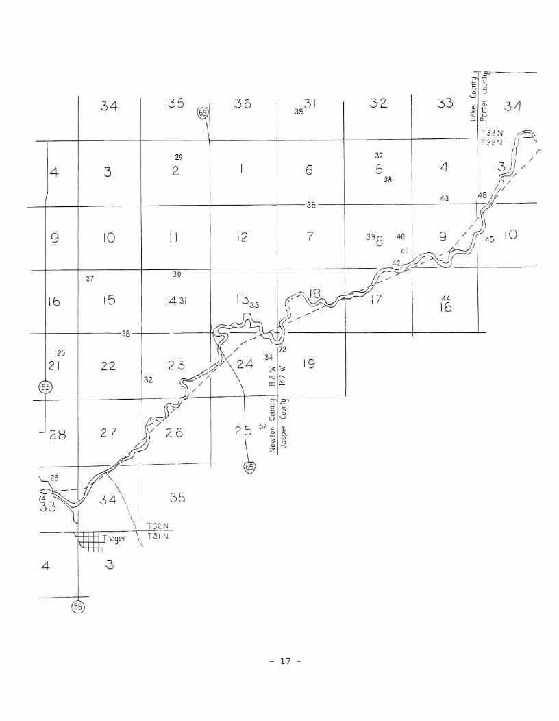
SOME 19th CENTURY FEATURES OE NORTHERN
EWTON COUNTY, IND ANA
54- Big Bogus Island
68 -Little Bogus Island
65 - Horse Thief Hill
33-Red Oak Island
WITH MODERN ROADS72- Range Line Bridge
52- West Black Marsh
51 - East Black Marsh
74- Thayer's Landing
ADDED75 - White Oak Landing
53- Blue Grass Landing
50- The "Skillets*
73 - Shafer's Ridge
- 8 -

PLACE-NAME SITES ON THE LOCATOR MAPS
1 - Ash Swamp Island2 - Sugar Grove Island3 - Black Oak Island4 - Crab Apple Grove5 - White Oak Island6 - Bolivar Island7 - Oak Grove Island8 - Kidlin Island9 - Stave Shanty
10 - Foley f s Island11 - Frenchman's Slough12 - Worley Point13 - Wheeler Knobs14 - Gale f s Island15 - River Ridge16 - Devil's Island17 - South Island18 - Sand Ridge19 - Grassmere Island20 - Flat Island21 - Brady Landing22 - Fuller Island23 - Little Grape Island24 - Skunk Knobs25 - John Brown & Son Island26 - Water Valley27 - Ridge Island28 - Little Eagle Island29 - Long Willow Grove30 - W. B. Brown31 - Warner Island32 - Brownell's Island33 - Red Oak Island34 - Indian Garden35 - Pearce Ridge36 - Carraboe Island37 - Burst Timber Island38 - Walnut Knobs39 - Little Beech Ridge40 - Big Beech Ridge41 - Burnt Timber Island42 - Hog Marsh43 - Goose Lake44 - French Island45 - Grape Island46 - Long Ridge47 - Indian Island48 - Deserter's Island49 - Baum's Bridge50 - The Skillets51 - East Black March52 - West Black Marsh53 - Blue Grass Landing54 - Bogus Island55 - Dunn's Bridge
56 - English Lake57 - Forest City58 - Fort Kankakee59 _ Fxy*6 Landing60 - Garden of Eden61 - Hebron Bridge62 - Hebron Canal63 - Hess 1 Slough64 - Upper Crossing65 - Horse Thief Hill66 - Horse Thieves Bridge67 - Hyde's Island68 - Little Bogus Island69 - Mayville70 - North Bend71 - Lew Wallace Residence72 - Range Line Bridge73 - Shafer f s Ridge74 - Thayer's Landing75 - White Oak Landing
Ash Swamp Island - 1 Baton 1 s Bridge - 49 Big Beech Ridge - 40 Black Marsh, East - 51 Black Marsh, West - 52 Black Oak Island - 3 Blue Grass Landing - 53 Bogus Island - 54 Bolivar Island - 21 Brady Landing - 21 Brownell's Island - 32 Burnt Timber Island - 41 Burst Timber Island - 37 Camp 6-2 Island - 48 Carraboe Island - 36 Cherry Island - 68 Coal Pitt Island - 47 Crab Apple Grove - 4 Deserter's Island - 48 Devil f s Island - 16 Dunn's Bridge - 55 Eaton 1 s Bridge - 49 Ed Haskell's Island - 9 English Lake - 56 Flag Pond - 70 Flat Island - 20 Foley's Island Forest City - 57 Fort Kankakee - 58 French Island - 44 Frenchman's Slough - 11 Fry's Island - 59 Fry's Landing - 59
Fuller Island - 22Gale's Island - 14Garden of Eden - 60Goose Lake - 43Grape Island - 45Grassmere Island - 19Hebron Bridge - 61Hebron Canal - 62Hess* Slough - 63Hill 8 s Ford - 64Hog Marsh - 42Horse Thief Hill - 65Horse Thieves Bridge - 66Hyde's Island - 67Indian Garden - 34Indian Island - 47Island 6-2 - 48Island Sixty-Two - 48John Brown & Son Island - 25Kidlin Island - 8Lew Wallace Residence - 71Little Beech Ridge - 39Little Bogus Island - 68Little Eagle Island - 28Little Grape Island - 23Lone Tree Island - 67Long Ridge - 46Long Willow Grove - 7Mayville - 69North Bend - 70Oak Grove Island - 7Pearce Ridge - 35Potawatomi Ford - 49Range Line Bridge - 72Red Oak Island - 33Ridge Island - 27River Ridge - 15Sand Ridge - 18Shafer's Ridge - 73Skillets, The - 50Skunk Knobs - 24South Island - 17Stave Shanty - 9Sugar Grove Island - 2Thayer f s Landing - 74Upper Crossing - 64Upper Engine Town - 60Walnut Knobs - 38Warner Island - 31Water Valley - 26W, B. Brown - 30Wheeler Knobs - 13White Oak Island - 5White Oak Landing - 75Worley Point - 12

of Newton County, Indiana* in the ffLa Salle State Fish and Wildlife Area'8 (s %, NE %, Sec. 6, T-31-N, R-9-W, on the Schneider Quadrangle, 7.5 Minute Series topographic map)* This island no longer exists. Site #3 on the locator maps.
BLIND BAYOU: (Wallace & Bowser* page 18,) Location unknown.BLUE GRASS LANDINGS (Burroughs, page 89; Wallace & Bowser, page 22.) A landing on the
south side of the old river, apparently at the mouth of Blue Grass Creek, located in the SE %, SW %, SW %, Sec, 1, T-31-N, R-9-W, on the Schneider Quadrangle, 7.5 Minute Series topographic map, in Lake Township of Newton County, Indiana, Blue Grass Road leads to the landing. Blue Grass Road is located 2,53 miles east of U.S. Highway 41, on Indiana Highway 10. Site #53 on the locator maps.
BOGUS ISLANDS (Burroughs, pages 160-161,) One of the secluded islands in the marshlands of northern Newton County, Indiana, which were used by the "bandititti of the prairie'9 as a base of operations for their nefarious criminal enterprises from about 1836 to 1858. Located in the southeast quarter-section of Section 7 in Colfax Township of Newton County, Indiana (SE %, Sec. 7, T-30-N, R-8-W, on the Enos Quadrangle, 7.5 Minute Series topographic map). Said Bogus Island was on the east fringe of Beaver Lake, hidden within the marshland forest. The island-ridge is about a half-mile in length by about 800 feet in width, and rises about 25 feet above the general ground surface. The axis of the ridge is from northeast to southwest with the steeper slope being on its southeast side. Site #54 on the locator maps.
BOILING SPRINGS: (Wallace & Bowser, page 64.) Location unknown.BOLIVAR ISLAND; (Ahlgrim map? Ball, page 353.) Located on the half-section line (centered
in the south half thereof) of Section 28 in West Creek Township of Lake County, Indiana (Center, S ^, Sec. 28, T-32-N, R-9-W, on the Schneider Quadrangle, 7.5 Minute Series topographic map). The site of this island still exists on the west side of U.S. Highway 41 close to the town of Schneider, Indiana. Various buildings now occupy the site located about 0.3-mile northwest of the Conrail railroad crossing. Site #6 on the locator maps.
BOOT HILL; (Wallace & Bowser, page 71.) One of the various terms used to describe the Mayville Cemetery. Actual site unknown,
BRADY LANDING.8 (Ahlgrim map.) On the south side of the river, located at the half-section line of the north half-section, Section 6 in Lincoln Township of Newton County, Indiana (Center, N \, Sec. 6, T-31-N, R-8-W, on the Schneider Quadrangle, 7.5 Minute Series topographic map). Said landing site still exists at the north end of an unimproved road (on the 1959 topographic map), but the site is now a bayou of the channelized river. Site #21 on the locator maps.
BRAINARD CUTOFF: (Wallace £ Bowser, page 22.) Location unknown, but apparently just downstream of the Hebron Bridge.
BRIDGE ISLAND.- (Werich, pages 183-184.) Apparently a part of the former Potawatomi Trail, this island site is now located along Indiana Highway 49 from about 500 South Road to Baum's Bridge Road in the area north of Kouts, Indiana.
BROWNELL'S ISLAND; (Ahlgrim map; Ball, page 353.) Located on the west section line ofSection 23, but mostly was in the southwest quarter-section of said Section 23, in Eagle Creek Township of Lake County, Indiana (SW %, Sec. 23, T-32-N, R-8-W, on the Shelby Quadrangle, 7.5 Minute Series topographic map). The site of this former island is on the west side of Interstate Highway 65, about 1.25 miles west of the highway, and about 1.9 miles east-northeast of the village of Shelby, Indiana, In 1959 part of the grove on this island was still in existence. Site #32 on the locator maps.
BUCK'S RIDGE: (Werich, pages 43 and 95.) Location unknown.BULL FOOT GROVE: (Corbin, page 11, column one.) In Newton County, Indiana, but its location
is unknown.BUMBALOO: (Burroughs, page 101.) The wilderness home of Hank Granger, located slightly
east of Shelby, Indiana.BURNT TIMBER ISLAND: (Ahlgrim map.) Located immediately south of Big Beech Ridge, this
grove of timber was mostly in the southeast quarter-section of Section 8 in Eagle Creek Township of Lake County, Indiana (SE %, Sec. 8, T-32-N, R-7-W, on the De Motte Quadrangle, 7,5 Minute Series topographic map). This island no longer exists. Site #41 on the
- 10 -

Baum's Bridge and Fry 1 8 Landing.CORNELL'S CREEK; (Wallace & Bowser, page 27,) Originally a tributary to Sandy Hook Creek,
but now a tributary to the Phillips Ditch* Said creek is now the Cornell Ditch and can be found on the Hebron and Kouts quadrangles, 7.5 Minute Series topographic maps. The mouth of the Cornell Ditch at the Phillips Ditch is in the NE \, Sec. 21, T-33-N, R-6-W on the Kouts Quadrangle.
CORNELL'S ISLAND? (Wallace & Bowser, page 22; Werich, page 43.) Location unknown, but it was apparently located slightly upstream of Fry's Landing.
CORNELL'S UPPER ISLANDS (Fry I, page 15.) Location unknown.CORNERS, The: (Fry 2, page 19.) Prior to 1845 the settlement which would become Hebron
was known as "The Corners,"CRAB APPLE GROVE: (Ahlgrim map; Ball, page 353.) A grove or island located in the southwest
corner of the northeast quarter-section of Section 19 in West Creek Township of Lake County, Indiana (SW £, NE £, Sec. 19, T-32-N, R-9-W, on the Schneider Quadrangle, 7.5 Minute Series topographic map). As of 1959 a part of this grove of trees still existed on the east side of "West Creek," about 1.5 miles west of U.S. Highway 41 and about 2.1 miles south of Indiana Highway 2. Site #4 on the locator maps.
CROOKED CREEK: (1876 Indiana Atlas.) A Porter County stream, tributary to the Kankakee River, found in Pleasant Township, Essex Township, and Washington Township. The lower four miles of said Crooked Creek is now known as the Heinold Ditch. The mouth of the stream at the Kankakee River is located upstream of the Baum's Bridge.
CUMBERLAND LODGE: (Nichols, pages 165-166.) A 23-rooms manor house built in 1872 by Sir
Place-Name SHe
Section number
f j - State Highways
U.S. Highways
- Interstate Highways
THE KANKAKEE RIVER (MARSH) BEFORE AND AFTER CHANNELIZATION
- Kankakee River before channelization
- KanKakee River after channelization
N
£4 - The Upper Crossing
60- Garden of Eden
63- Hess' Slough
34 - Indian Garden (Illinois)
x - Vail's Island
50- The "SKillets*
One Mile -, 5 °
cc
19
3

Siid
the river. It was a«.22 - 64-65;
aPParently on the north side of

Siid
the river. It was a«.22 - 64-65;
aPParently on the north side of

block square and was located about 150 yards back from the river, in the trees. As per Its description, the said location of the island should be in the center of the south- half of the south-half of the southwest quarter-section of Section 3 in Boone Township of Porter County, Indiana (center, S ^, S %, SW \ 9 Sec. 3, T-32-N, R-7-W, on the De Motte Quadrangle* 7.5 Minute Series topographic map). Said location is in the far southwest corner of Porter County, about 1300 feet east of the Lake/Porter county line and about 0.8-mile west of U.S. Highway 231, Site #48 on the locator maps,
DESERTER'S PARADISE? (Wallace & Bowser, page 71,) A synonym for the pioneer settlement of Mayville,
DEVIL'S ISLAND? (Ahlgrim map,) A genuine island in the former Kankakee River (not in the marsh) which was located in the center of the south-half of Section 2 in Lake Township of Newton County, Indiana (center, S %, Sec, 2, T-31-N, R-9-W, on the Schneider Quadrangle, 7.5 Minute Series topographic map). Then as now this site is all wetlands. Site #16 on the locator maps,
DEVIL'S LANEs (Wallace & Bowser, page 22,) Location unknown, but apparently was between Fry's Landing and the Hebron Canal,
DIANA CLUB HOUSE: (Nichols, page 167,) A hunting club located at Water Valley in Cedar Creek Township of Lake County, Indiana,
DOG-FISH POOL; (Wallace & Bowser, page 22; Fry I, page 15,) Location unknown, but apparently immediately downstream of the Hebron Bridge,
DONELY RESORT: (Hodson, page 60,) A hunting club on the Kankakee River, location unknown,DOUBLE CUTOFF: (Wallace 7 Bowser, page 22,) Location unknown, but apparently between the
Hebron Bridge and Grape Island,DRAGOON TRACE: (Bartlett, page 224,) A military road or path from Fort Wayne to Fort
Dearborn,DUNN'S BRIDGE: (Nichols, page 166; Wallace & Bowser, page 48.) Constructed in 1888 at the
point on the river where downstream flow changes from a southwest direction to a northwest direction. Located between English Lake and Baum's Bridge^ it is on the east section line of Section 15 in Pleasant Township, Porter County, and/or Kankakee Township, Jasper County (Sec. 15, T-32-N, 'R-5-W, on the San Pierre Quadrangle, 7,5 Minute Series topographic map). Site #55 on the locator maps.
DUTCH ISLANDS (McCormick, page 44,) Location unknown, but apparently associated with English Lake in Starke County, Indiana,
- E -
EAGLE BAYOU: (Wallace & Bowser, page 22.) Location unknown, but apparently between Fry's Landing arid the Hebron Canal.
EAGLE POINT: (McCormick, page 44.) Location unknown, but apparently associated with English Lake in Starke Countyj Indiana,
EATON'S BRIDGE: (Werich, pages 101-103; Wallace & Bowser, page 72,) The first bridgebuilt across the Kankakee River at the Potawatomi Ford. Built in 1849, the bridge burned down in 1850. George Eaton had his cabin on the north bank of the river, Eaton died in 1851. Site #49 on the locator maps.
EATON'S FERRY: (Werich, page 101; Wallace & Bowser, page 63; Fry I, page 15,) The ferry founded by George Eaton at Potawatomi Ford, c, 1836, apparently replacing Jerry Sherwood's ferry of 1835,
ED HASKELL'S ISLAND: (Ahlgrim map,) Located in the center of the east-half of the east- half of Section 34 in West Creek Township of Lake County, Indiana (center, E %, E %, Sec. 34, T-32-N, R-9-W, on the Schneider Quadrangle, 7.5 Minute Series topographic map). Said island's location is still an elevated grove of trees situated about a mile east- southeast from Schneider, Indiana. Site #9 on the locator maps,
ELLEN CUTOFF: (Wallace & Bowser, page 22.) Location unknown, but apparently between the Hebron Canal and the Hebron Bridge.
ENGLISH LAKE: (Isaacs, pages 34 & 72; Nichols, page 86; Werich, page 121.) Originallyknown as the "Grand Marais." Potawatomi Indian chiefs Shabbona and Peashaway once lived near here. Said lake was a widewater segment of the Kankakee River measuring about ten
- 14 -

miles in length and two miles in width at its widest point, located along the county line between La Porte and Starke counties in Indiana, The Alien Trace crossed the river at the lower end of this lake* Site #56 on the locator maps.
ESSIGS POINTs (Illiana Heights Quadrangle,,) Northeast point of Vails Island,,
- F -
FLAG PONDs (Werich, page 36,) An early name for the "North Bendsf of the river. Site #70 on the locator maps*
FLAT ISLANDs (Ahlgrim map,) Located in the southeast corner of the northeast quarter-section of Section 31 in Cedar Creek Township of Lake County, Indiana (SE %, NE %, Sec* 31, T-32-N, R-8-W, on the Shelby Quadrangle, 7,5 Minute Series topographic map). Site #20 on the locator maps.
FOGLI CLUB HOUSEs (Nichols, pages 167-168.) A twelve-suite hunting lodge located at Water Valley on the north side of the old Kankakee River, Said building was still in existence in 1965.
FOLEY'S ISLANDs (Ahlgrim map,) Was formerly located at the south section line in thesoutheast corner of the southeast quarter-section of Section 34, on the north side of the river in the extreme southeast corner of West Creek Township in Lake County, Indiana (SE %, SE %, Sec, 34, T-32-N, R-9-W, on the Schneider Quadrangle, 7.5 Minute Series topographic map). This island was apparently totally destroyed by the construction of the Dike Ditch. Said island was about one mile southeast of Schneider, Indiana. Site #10 on the locator maps.
FOREST CITYs (Ahlgrim map.) An apparent settlement which existed 100-years ago, but no longer exists today. It was located south of the river along what is now the Conrail railroad tracks (north side thereof) in the northeast quarter-section of Section 25 in Lincoln Township of Newton County, Indiana (SE %, NE %, Sec. 25, T-32-N, R-8-W, on the Shelby Quadrangle, 7.5 Minute Series topographic map). Site #57 on the locator maps.
FORT HUAKIAs (Wallace & Bowser, page 79.) A synonym for Fort Kankakee,FORT KANKAKEEs (Wallace & Bowser, pages 41, 43, 45 & 47.) An old fortified position having
an area of about four acres, high dirt walls, and an elliptical shaped trench, located in the north half of the southwest quarter-section of Section 22 in Pleasant Township of Porter County, Indiana (N %, SW %, Sec. 22, T-33-N, R-6-W, on the Kouts Quadrangle, 7.5 Minute Series topographic map). Site #58 on the locator maps.
FRENCH ISLANDS (Ahlgrim map; Isaacs, pages 41 & 52; Werich, pages 41, 121, 123 and 127-129; Burroughs, page 101.) This island was settled as early as 1790 by a French trader named La Bonta, Potawatomi Indian chiefs Shabbona and Peashaway once lived here. Located in the center of Section 16 in Keener Township of Jasper County, Indiana (center, Sec. 16, T-32-N, R-7-W, on the De Motte Quadrangle, 7.5 Minute Series topographic map). This elevated land is located about 2.57 miles northwest of the townhall of DeMotte, Indiana. Said island is at the west end of a 10-15 feet high sand-ridge running eastward about 1% miles to the west-half of Sec. 14, T-32-N, R-7-W. Site #44 on the locator maps.
FRENCHMAN'S SLOUGHs (Ahlgrim map.) A slough located southwest of the old river in the area of what is now the Sumava Resorts in Lake Township of Newton County, Indiana. Said slough had an arc-shape running from the northeast quarter-section of Section 3, to the southwest quarter-section of Section 2 (NE %, Sec. 3, and SW ^, Sec. 2, all in T-31-N, R-9-W, on the Schneider Quadrangle, 7.5 Minute Series topographic map). Site #11 on the locator maps.
FRY'S ISLANDs (Werich, page 43; Fry I, page 3; Alyea interview.) As per Ira M. Fry, Fry's Island and Fry's Landing were located "Some three and one-half miles downstream from Baum's Bridge." Mr, Raymond Alyea, a resident of the Hebron area, places the location of the island and the landing in, what is now, the NE %, NW %, Sec. 29, T-33-N, R-6-W (on the Hebron Quadrangle, 7.5 Minute Series topographic map). Site #59 on the locator maps.
FRY'S LANDINGS (Fry I, page 3; Alyea interview.) Refer tos "Fry's Island."FULLER ISLANDs (Ahlgrim map.) A former large island in Lake County, Indiana, occupying
parts of four topographic sections, but mostly located in Section 5 of Cedar Creek Township. Parts of the island are on three topographic quadrangles.* Leroy, Schneider,
- 15 -

and Shelby; in Sections 4, 5, 6 and 7 of T-32-N, R-8-W. The east tip of the formerisland is crossed by Indiana Highway 55* just north of the Singleton Ditch (about 2.6miles south of Indiana Highway 2)* Site #22 on the locator maps.
r*
GALE'S ISLAND; (Ahlgrim map.) A former island in the marsh located about 1*9 miles east- northeast from the town of Schneider, Indiana, in the center of the east-half of Section 26 in West Creek Township of Lake County, Indiana (center, E %, Sec. 26, T-32-N ? R-9-W, on the Schneider Quadrangle, 7.5 Minute Series topographic map)- Site #14 on the locator maps*
GARDEN OF EDEN; (Hess, page 147, column two; Burroughs, pages 89 £ 212; Wallace & Bowser, page 22.) A site in Illinois, still in existence, and still called the "Garden of Eden." Located immediately west of Joe Barbee's "Indian Garden," in the southwest quarter- section of Section 13 in Momence Township of Kankakee County, Illinois (in the SW %, Sec, 13, T-31-N, R-14-E, on the Illiana Heights Quadrangle, 7,5 Minute Series topographic map). Said "Garden of Eden" was also known as "Upper Engine Town." Site #60 on the locator maps,
GEORGE OLDS' LANDING; (Hess, page 147, column two.) In Illinois, on the south side of the river, located west of the "Garden of Eden." Exact location unknown,
GOD'S HALF ACRE: (Wallace & Bowser, page 71.) One of the various terms used to describe the Mayville Cemetery. Actual site unknown.
GOOSE ISLAND: (Werich, pages 76 & 83.) Location unknown, but may have been near Peach Island.
GOOSE LAKE: (Ahlgrim map; Werich, page 163.) Also known as Goose Pond, it was located due north of French Island. Ahlgrim gives its location as being north of the river, but Werich places it south of the river in Jasper County. Ahlgrim 1 s location is on the north side of the river, near the south section line of Section 4 in Eagle Creek Township of Lake County, Indiana (center, S %, S %, Sec. 4, T-32-N, R-7-W, on the De Motte Quadrangle 7.5 Minute Series topographic map). Site #43 on the locator maps.
GOOSE POND: See, "Goose Lake."GRAND MARAIS: (Isaacs, page 34.) The original name for "English Lake."GRAND PRAIRIE: (Corbin, page 17, column one.) That part of the Indiana prairie extending
from the Iroquois River to Lafayette, Indiana.GRAPE ISLAND: (Ahlgrim map; Alyea interview; Nichols, pages 147-148; Burroughs, pages 101
& 214; Werich, pages 49 & 141; Isaacs, page 41; Fry I, page 15; Wallace & Bowser, page 22; McCormick, page 44.) Although there may have been a Grape Island associated with English Lake in Starke County, Indiana, most references to said island are for the island in Jasper County, even though there was also a Little Grape Island in Lake County, Indiana, Said Grape Island in Jasper County was located on the south side of the river in the northwest corner of the southwest quarter-section of Section 10 in Keener Township, about 0.75-mile west of U.S. Highway 231, immediately north of the Hodge Ditch (in the NW £, SW %, Sec. 10, T-32-N, R-7-W, on the De Motte Quadrangle, 7.5 Minute Series topographic map). Said island may have been settled by the French as early as 1790. Site #45 on the locator maps.
GRASSMERE ISLAND: (Ahlgrim map.) This was a grove or island mostly located along the east section line of the southeast quarter-section of Section 18 in Cedar Creek Township of Lake County, Indiana, but also includes a 15-20 feet high knob immediately east of that section line in the southwest quarter-section of Section 17 (in the E %, SE %, Sec* 18, T-32-N, R-8-W, on the Shelby Quadrangle, 7.5 Minute Series topographic map). In 1959 said knob in Section 17 was located on the north side of the Brown Ditch, slightly west of the Louisville & Nashville railroad tracks. Site #19 on the locator maps.
GUINN'S ISLAND: (Werich, page 89.) Exact location unknown, but on the north side of the old river a little below the river's "North Bend."
GUM BRIDGE: (Wallace & Bowser, page 22.) Location unknown, but apparently between Baum's Bridge and Fry's Landing.
- 16 -

- I -
INDIAN GARDEN! (Ahlgrim mapi Wallace & Bowser* page 47| Morrison* page 7* column two; Burroughs* pages 89, 101 & 212; Werich* page 28.) The Indian Gardens were areas of cleared land with Indian plantings 9 and also? areas favored with Indian encampments. In the Kankakee Marsh there were at least three Indian Gardens* one in Illinois and the other two in Indiana- (a) The Illinois Indian Garden was located immediately east of the "Garden of Eden/9 on the north side of the river* approximately in the SE %, Sec, 13, T-31-N, R-14-E* on the Illiana Heights Quadrangle. (b) The first of the two known Indian Gardens in Indiana is that located on both sides of Range Line Road* south of the river* in the northeast comer of Newton County* overlapping into Jasper County, This location in the SE %, NE %* Sec, 24* T-32-N* R-8-W* was apparently erroneously described as being the site of Indian Island and the Indian Island Sawmill on page 127 of the WPA's book* "The Calumet Region Historical Guide." In 1940 this site was the "Cameron Game Preserve" in Lincoln Township of Newton County* Said Indian Garden site in Newton County is on the Shelby Quadrangle, (c) The second Indian Garden site in Indiana is the sand ridge located east of Sandy Hook Creek in Porter County* where hundreds of Indians camped during their winter hunting season. This Porter County "Indian Garden" is immediately west of Bauin f s Bridge in the N \ $ Sec. 27* T-33-N* R-6-W on the Kouts Quadrangle. All three Indian Garden sites are #34 on the locator maps*
INDIAN ISLAND? (Book T-2 of Deeds* page 244| Werich* pages 28* 131 & 134-135) Wallace & Bowser* page 55.) As per the Porter County Recorder's office in Valparaiso* Indiana* as recorded on pages 243 and 244 in Deed Book T-2* the Indian Island Sawmill Company was located in the SE %* Sec, 21* T-33-N* R-6-W* which said site is on the Kouts Quadrangle* on the south side of the Phillips Ditch* apparently on the high ground on both sides of "250 West Road" south of Aylesworth, The sawmill was built in 1866 and was apparently steam-powered. In order to bring coal to the island* and to take out the sawed-wood, a canal (the "Bissell-Cornell Steamboat Canal"), about 550-yards long* 18 feet wide* and 4 feet deep* was dug from the river to the island in 1868. Said canal is easily recognized on the topographic map. Indian Island was 35 to 40 acres in size. Said island was bought by Aaron Brody* Sr,* in 1854, The sawmill company bought the island from the Brody family and later sold parts of it back to Aaron R. Brody* J. L. Brody* and William Brody in 1866. Site #47 on the locator maps,
INDIAN STRETCH: (Wallace & Bowser, page 21.) Location unknown, but apparently between English Lake and Dunn's Bridge,
INDIAN TOWNs (Werich, page 36; Schoon* page 191.) The original name of Hebron* Indiana* but the original town was apparently located a half-mile south of the present town.
ISLAND 6-2: See, "Deserter's Island."ISLAND SIXTY-TWOs See* "Deserter's Island/ 9
- J -
JACKSON ISLAND.* (McCormick* page 44.) Location unknown* but apparently associated withEnglish Lake in Starke County, Indiana.
JAY f S ISLAND: (Wallace & Bowser* page 22.) Location unknown* but apparently between FrenchIsland and Indian Garden.
JERRY'S ISLANDS (Nichols* pages 172-173; Burroughs* page 101.) Location unknown. Named forJerry Kinney* it was apparently north of the Range Line Bridge.
JOHN BROWN & SON ISLANDS (Ahlgrim map.) Located on what is now the east side of IndianaHighway 55 about 1.3 miles north of Shelby, Indiana* in the center of the NE %, Sec. 21*T-32-N, R-8-W, on the Shelby Quadrangle* 7.5 Minute Series topographic map, in Cedar CreekTownship of Lake County* Indiana. Site #25 on the locator maps.
JOHN GELOW'S LANDING: (Wallace & Bowser, page 17.) Location unknown. JOHN'S BAYOU: (Wallace & Bowser, page 17.) Location unknown* but in the vicinity of John
Gelow's Landing. JOHNSON'S ISLANDS (Werich, page 73.) Location unknown* but apparently near Sandy Hook
Creek,
- 19 -

- K -
KAHLER'S BRIDGE: (Wallace & Bowser, page 47.) Location unknown.KALER'S LANDING: (Wallace & Bowser, page 27j Werich, page 140.) About 1895, Indian Island
was bought by Henry Kahler, of Chicago, who built a resort there for hunters andfishermen. Said "Kaler's Landing" was for that resort.
KANKAKEE CAMP: (Wallace & Bowser, page 57.) Kankakee Camp was the Kankakee State GamePreserve which was located on the same grounds where English Lake formerly existed.Said game preserve can be found on the "English Lake" and "Knox West" quadrangles. Thesaid game preserve is in LaPorte and Starke counties, and is accessed from IndianaHighway 8.
KANKAKEE VALLEY HUNTING CLUB: (Werich, page 140.) A hunting club house built on IndianIsland in 1908 by Henry Kahler of Chicago. Said lodge was later dismantled and removed.
KEY-HOLE, The: (Hess, page 148, column one.) Apparently the cut-off channel through thenech of a river meander or ox-bow.
KIDLIN ISLAND: (Ahlgrim map.) A grove or island located in the center of Section 27 in theWest Creek Township of Lake County, Indiana (where the Schneider, Indiana, airport is nowlocated) in T-32-N, R-9-W on the Schneider Quadrangle, 7.5 Minute Series topographic map.Site #8 on the locator maps.
KOHLER f S LANDING: (Wallace & Bowser, page 22.) See, "Kaler's Landing."
- L -
LA SALLE LANDING: (Wallace & Bowser, pages 11 & 85.) The south end of Baum's Bridge,which is in Jasper County, Indiana.
LEMMING BRIDGE: (Wallace & Bowser, page 48.) This site location is in error as there wasno Lemming Bridge across the Kankakee River, but there was a "Lemon Bridge" where the
- 20 -

Lemming Bridge was supposed to be located. The "Lemon Bridge" across the Kankakee River was constructed in 1840 and was the first bridge on the Kankakee located where State Route Number 4 is now located.
LITTLE BEECH RIDGE or LITTLE BEACH RIDGE: (Ahlgrim mapi Werich, pages 39 & 89.) A grove or island located on the half-section line in the east half of the west half of Section 8 in Eagle Creek Township of Lake County, Indiana. Today said island's site is located on the northwest side of the Brown Levee Ditch, (Center, E %, W \, Sec. 8, T-32-N, R-7-W, on
Crooked Creek
the east margin of the Shelby Quadrangle and the west margin of the De Motte Quadrangle, 7.5 Minute Series topographic maps. Site #39 on the locator maps.
LITTLE BOGUS ISLAND: (Burroughs, pages 145-147; Werich, page 46.) By calculations, as per directions given in Burt E. Burroughs' book, said island was located in the SE %, SW %, Sec. 4, T-30-N, R-9-W, in McClellan Township of Newton County, Indiana, on the Enos Quadrangle, 7.5 Minute Series topographic map. County Road "500 Nff crosses a portion of Little Bogus Island about 1800 feet east of "West Road." Little Bogus Island was located within the body of Beaver Lake (with a secret pathway leading through the deep water) and was one of the islands used as a hideout of the "banditti of the prairie" in the marshland's history from 1836 to 1870. Site #68 on the locator maps.
LITTLE EAGLE ISLAND: (Ahlgrim map.) Located on the north section line (in the center of the east half) of Section 22 in Cedar Creek Township of Lake County, Indiana (Sec. 22, T-32-N. R-8-W, on the Shelby Quadrangle, 7.5 Minute Series topographic map). In 1959 the site of this island was apparently the wooded area located north of the Tully Ditch, about 1.4 miles east of Indiana Highway 55, in the N %, NE \, NE %, Sec. 22, T-32-N, R-8-W. Site #28 on the locator maps.
LITTLE GRAPE ISLAND: (Ahlgrim map.) Located about 1.04 miles west of Indiana Highway 55 from a point about 1300 feet north of the Brown Ditch in Cedar Creek Township of Lake County, Indiana (SE \ 9 NW %, Sec. 17, T-32-N, R-8-W, on the Shelby Quadrangle, 7.5 Minute Series topographic map). Site #23 on the locator maps.
LITTLE HICKORY: (Wallace & Bowser, page 22; Burroughs, page 101.) Location apparently in
- 21 -

the area of the Indian Garden and Red Oak Island.LITTLE LANKAKEE: (Isaacs* page 12. ) Possibly a typographical error* Little Kankakee may
be the intended term. Location unknown, but a number of Indians were located there.LITTLE PARADISE ISLANDs (Werich, pages 37-38.) Near Crooked Creek, but downstream thereof.
The first American shanty was built here in 1845. Crooked Creek is located east of Kouts, Indiana* in Pleasant Township of Porter County. Crooked Creek's original mouth was in the NE %, Sec. 36, T-33-N, R-6-W (slightly upstream from Baum's Bridge), but the creek now becomes the Koselke Ditch southeast of Kouts, then the Heinold Ditch where it enters the channelized Kankakee River.
LITTLE SKILLETs (Hess, page 147, column two.) The skillets were two looping meanders in the river, apparently located at the Illinois/Indiana state line. Site #50 on the locator maps.
LITTLE WIDOW BONESTEEL'S BURYING GROUNDS (Wallace & Bowser, page 71.) One of the various terms used to describe the Mayville Cemetery. Actual site unknown.
LITTLE YELLOW BANKS; (Hess, page 146, column one; Burroughs, page 89.) Located in Illinois, this was the first noteworthy point on the river east of Momence, upstream of "The Upper Crossing1 * (Hubbard's Trail).
LONE TREE ISLANDS (Mansfield, page 1, column two; Hodson, page 5.) Located at the mouth of Crooked Creek. It was also known as "Hyde's Island,"
LONG ISLAND: (Wallace & Bowser, page 63,) Location unknown, but formerly known as "Hog Island."
LONG RIDGE: (Ahlgrim map; Fry I, page 3; Werich, page 170.) This remains a prominent,north-to-south oriented ridge located along the east section line of Sec. 2, T-32-N, R-7-W (in Keener Township of Jasper County), which said ridge is about four miles south of Hebron, Indiana, and one mile east of U.S. Highway 231. The ridge, on the Hebron and De Motte quadrangles, is south of the river, beginning near the intersection of "1700 North Road" with "625 West Road," and is about a mile in length, running through parts of sections 1, 2, and 12, It has a width of about 1800 feet, and rises to a height of about 25 feet above the general ground surface. Site #46 on the locator maps.
LONG WILLOW GROVEs (Ahlgrim map.) A narrow strip of trees along the south side of the Singleton Ditch in Eagle Creek Township of Lake County, Indiana. (In the N \ 9 Sec, 2, T-32-N, R-8-W, on the Leroy Quadrangle, 7,5 Minute Series topographic map.) Site #29 on the locator maps.
LORAIN: (Nichols, page 89,- Burroughs, pages 3, 18 & 36.) Another term for the "Upper Crossing."
LOST BRIDGE: (Wallace & Bowser, pages 35 & 57.) A bridge across the Kankakee River in the Kankakee State Game Preserve that is only used by pedestrian traffic.
LOUDGE BRIDGE: (Wallace & Bowser, page 48.) A bridge across the Kankakee River, but its location is not known,
LOUISVILLE HUNTING CLUB: (Werich, page 107; Nichols, page 167; Hodson, page 5.) TheLouisville club house was built on the south bank of the old Kankakee River in the Baum's Bridge area. Its membership was from Louisville, Kentucky. Built in 1878, it was later condemned as a fire hazard and was torn down in 1928.
LOWER ENGINE TOWN: (Hess, page 147, column two.) On the north side of the Kankakee River in Illinois, west of, but near, the "Garden of Eden."
LYND'S LANE: (Burroughs, page 105.) The road leading north from Illinois Highway 114 to Hess 1 Slough.
- M -
MAGNOLIA MARSH: (Wallace & Bowser, page 22.) Location unknown, but apparently between French Island and the Indian Garden.
MAYVILLE: (Wallace & Bowser, pages 69-72; Hodson, page 85.) A pioneer settlement on the north side of the old Kankakee River in the area of Baum's Bridge which eventually was vacated. The actual location of the settlement is unknown, but it apparently was in the SW %, SE % 9 Sec. 26, T-33-N, R-6-W (Pleasant Township of Porter County), on the Kouts Quadrangle, 7.5 Minute Series topographic map. Site #69 on the locator maps.
- 22 -

MIKE f S ISLANDS (Werich, page 131.) Another term for "Indian Island* 81 Named for MikeHaskins who formerly lived there.
MORGAN PRAIRIE; (Werich, page 33.) The land on the east side of Sandy Hook Creek. Named forIsaac and William Morgan who settled there in 1833,
- N -
NARROWS, Thes (Nichols, page 89j Burroughs, page 89; Isaacs, page 75.) A point between theIllinois state line and Blue Grass Landing at which a trail led across the old KankakeeRiver.
NEW RIVER; (Hess, page 148, column one.) Apparently the new channelized Kankakee River* NORTH BEND; (Werich, pages 36-37.) That point where the old Kankakee River flowed farthest
north* Apparently said point was in the SE %, SE %, SE % r Sec, 20, T-33-N, R-6-W, inBoone Township of Porter County, Indiana. Said point on the old ri /er is immediately westof the mouth of the Sandy Hook, on the left margin of the Kouts Quadrangle, 7.5 MinuteSeries topographic map. Site #70 on the locator maps.
NORTH MARSH: (Werich, page 36; Wallace & Bowser, page 22.) The marshland north of the riverin the area of the "North Bend."
NORTH TIMBER; (Corbin, page 17, column two.) The wooded area south of Morocco, Indiana.
- 0 -
OAK GROVE ISLAND: (^hlgrim map.) A large forested island occupying most of the south half of Section 16 in West Creek Township of Lake County, Indiana, This grove was about 1,6 miles long by a third-of-a-mile wide. It was located about 2\ miles north of Schneider, Indiana, or about one mile north of the Singleton Ditch, on U.S. Highway 41 on the west end of the island. (It was in the S \, Sec. 16, T-32-N, R-9-W, on the Schneider Quadrangle, 7.5 Minute Series topographic map.) Site #7 on the locator maps.
OLD FORT: (Wallace & Bowser, pages 41, 43, 45 & 47.) See, "Fort Kankakee."OLD INDIAN TOWN; (Wallace & Bowser, page 26.) See, "Indian Town."OLD RIVER: (Hess, page 148, column one.) Apparently the original Kankakee River, as
opposed to the channelized river,OSTEN LANDING; (Wallace & Bowser, page 48.) Location unknown.OX-BOW, The; (Hess, page 147, column two; Burroughs, page 89$ Wallace & Bowser, pages 17,
19, 36 & 37. Apparently there were two "Ox-Bow" features on the old Kankakee River in Indiana; One near the Illinois state line, and the other just upstream of Baum's Bridge, (a) The "Ox-Bow" near the Illinois state line was a loop-like bend in the river located in the NW %, NW \ 9 Sec. 5, T-31-N, R-9-W, about two miles east of the state line in the "La Salle State Fish and Wildlife Area" in West Creek Township of Lake County, on the Schneider Quadrangle. (b) "The Ox-Bow" that is located just upstream of Baum's Bridge is probably the loop-like bend in the old river at the mouth of Crooked Creek (in the NE \ 9 Sec. 36, T-33-N, R-6-W on the Kouts Quadrangle) or the loop-like bend immediately downstream thereof (in the SE %, NW \ 9 Sec. 36, T-33-N, R-6-W on the Kouts Quadrangle),
OX-BOW BEND2 (Nichols, page 1645 Wallace & Bowser, page 21-) General Lew Wallace (who wrote "Ben Hur") took up residence on Section 7, T-32-N, R-5-W, located upstream of Baum's Bridge in Wheatfield Township of Jasper County. Site #71 on the locator maps. Said property is supposed to have been on the river at Ox-Bow Bend. However, Section 7 has no frontage on the river, so the ox-bow bend so stated must refer to the ox-bow at the mouth of Crooked Creek,
- p
PARADISE ISLAND: (Nichols, page 166; Wallace & Bowser, page 18.) Location unknown, but wasapparently at the "Swift Cut-off."
PEACH ISLAND: (Werich, page 76.) Location unknown.PEACH RIDGEs (Werich, page 78.) Location unknown, but apparently near Peach Island. PEARCE RIDGE: (Ahlgrim map.) Located in the north half of the southwest quarter-section of
- 23 -

Section 31 in Eagle Creek Township of Lake County* Indiana. (In the N \ 9 SW % > Sec. 31, T-33-N, R-7-W, on the Leroy Quadrangle* 7,5 Minute Series topographic map.) Site #35 on the locator maps*
PIGEON ISLAND: (Burroughs, page 119.) Location unknown.PIGEON ROOST: (McCormick, page 44.) Location unknown, but apparently associated with
English Lake in Starke County, Indiana.PITTSBURGH HUNTING CLUBi (Nichols, pages 157, 161-1625 Werich, page 106.) Apparently was
located on the north side of the old Kankakee River in the Baum's Bridge area. Said building was built in 1878; was sold by the Pittsburgh based clum in 1915; and was destroyed by fire on January 5, 1966.
POINT COMFORT; (Wallace & Bowser, page 49.) Location unknown.POTAWATOMI FORD or POTTAWATTOMIE FORDs (Isaacs, page 36; Werich, pages 101-103; Nichols,
pages 158-159; Wallace & Bowser, page 69.) Located at what is now Baum's Bridge (in the SW %, SW t, SE \ 9 Sec. 26, T-33-N, R-6-W, on the Kouts Quadrangle), said ford was where the Potawatomi Indians crossed the Kankakee River on the Potawatomi Trail. Said fording place was the only place where the river could be crossed for miles up and down the river. Site #49 on the locator maps,
POTAWATOMI TRAIL or POTTAWATTOMIE TRAIL? (Werich, page 27.) The trail across the Kankakee River in the Kankakee Marsh leading to the Great Lakes.
PRAIRIE BEND; (Fry I, page 15; Wallace & Bowser, page 22.) Located between Baum's Bridge and Kohler's Landing.
PRAIRIE STRAIGHT: (Nichols, page 166.) Location unknown.
- R -
RAFT BAYOUs (Wallace & Bowser, page 22.) Location unknown, but apparently in the vicinity of the Hebron Canal and the Hebron Bridge.
RANGE LINEs (Wallace & Bowser, pages 17 & 22,) Location unknown, but apparently between Kohler's Landing and the Hebron Canal.
RANGE LINE BRIDGES (Nichols, pages 172-173.) A bridge built in 1927 by the three counties of Lake, Jasper and Newton in Indiana. As per Nichols it was south of Jerry's Island. On the Shelby Quadrangle it is on Range Line Road which is the road between R-7-W and R-8-W, just east of U.S. Highway 41. Site #72 on the locator maps.
RANGE LINE ROAD: See, "Range Line Bridge.* 1RED OAK ISLAND: (Isaacs, page 74; Werich, page 39; Burroughs, page 101; Wallace & Bowser,
page 22; Ahlgrim map.) Located about 0,45-mile north of the Kankakee River, about 0.35-mile west of Range Line Road, and about 0.65-mile east of U.S. Highway 41 in Eagle Creek Township of Lake County, Indiana. It is in the NW %, SE %, Sec. 13, T-32-N, R-8-W, on the Shelby Quadrangle, 7.5 Minute Series topographic map. Two trading posts were located on this island: That-of James Bertrand at the island's east end, and that of Louis La Voir at the west end. Also, some 200 Potawatomi Indians are known to have camped here. Site #33 on the locator maps.
RICE'S RIDGE: (Werich, page 43.) Location unknown.RIDGE ISLAND: (Ahlgrim map.) A f'U"-shaped series of hills located on the north side of the
Brown Ditch about midway between Indiana Highway 55 and U.S. Highway 41 in Eagle Creek Township of Lake County, Indiana. The hills are located mostly in the S %, S %, Sec. 10, and the NW %, NW %, Sec. 15, all in T-32-N, R-8-W, on the Shelby Quadrangle. Site #27 on the locator maps.
RIVER RIDGE: (Ahlgrim map.) This ridge still exists along the north side of the southsection line of Sections 35 and 36 in Cedar Creek Township of Lake County, Indiana. Said ridge is on the north side of the Kankakee River (located northeast of the Sumava Resorts) in the S %, S \, Sec. 35, and the S %, SW \, Sec. 36, all in T-32-N, R-9-W, on the Schneider Quadrangle, 7.5 Minute Series topographic map. In 1959 the 30-feet-high hill at the west end of the ridge (in the SW %, Sec. 35) was still covered with trees. Site #15 on the locator maps.
RIVER ISLAND: (Wallace & Bowser, page 22.) The island in the Kankakee River at Momence, Illinois, also known as "Island Park" in Momence, Located mostly in the N %, Sec. 19,
- 24 -

SANDY HOOK MARSHs (Wallace & Bowser* page 43*) The marshland along* and on either side of, Sandy Hook Creek.
SAN PIERREt (Isaacs* page 72,) A village in Starke County* Indiana* where a number of Indians were once located.
SCHOOL GROVE ISLANDS (Nichols* page 165; Ball* page 353*) Apparently where the Milligan Camp was located* said land now being crossed by U«S* Highway 41.
SCOTT'S TRADING POST: (Isaacs* page 46; Werich* page 28.) Scott s s Trading Post was located on the Potawatomi Trail (at Tassinong) and stood approximately in the area where Baum's Bridge Road meets Indiana Highway 49 near Kouts* Indiana.
SHAFER'S RIDGEs (Corbin* page 15* column two; Burroughs* pages 160-161.) Where Mike Shafer lived. Mike Shafer was one of the f'bandititti of the prairie 19 who was killed in 1869. Snafer's house was on an oak-studded sand ridge along the northern edge of the Black Marsh. Said ridge was two miles west and 1% miles south of the village of Roselawn* Indiana* in Lincoln Township of Newton County* on the north half of the east section line of Sec. 21* T-31-N* R-8-W* on the Shelby Quadrangle* Site #72 on the locator maps,
SHANTY ISLAND? (Werich* pages 42-43,) Location unknown,SHERWOOD FERRYs (Nichols* page 169; Wallace & Bowser* pages 63 & 72,) In 1834* Jerry
Sherwood had a ferry service where the Eaton Bridge was later built. Said site is now the location of Baum's Bridge*
SINGLETON DITCHs (Werich* page 185.) First successful ditch dug in Lake County* Indiana*SIXTY-TWO CLUB HOUSE? See* "Deserters Island,"SKUNK KNOBS: (Ahlgrim map.) Located on the section line between Sections 17 and 20 in
Cedar Creek Township of Lake County* Indiana (T-32-N* R-8-W) on the Shelby Quadrangle. These knobs are located about 1.6 miles north-northwest of Shelby* Indiana* between the Louisville & Nashville Railroad and Indiana Highway 55, Site #24 on the locator maps,
SNAKE ISLANDS (Wallace & Bowser* page 64,) Location unknown*SOLDIER'S CLAIMs (Wallace & Bowser, pages 17 £ 22.) Location unknown* but apparently
between Fry's Landing and the Hebron Canal.SOUTH ISLAND; (Ahlgrim map*) This island or grove was located on* what is now* the east
side of Colfax Street* about 0,75-mile south of the Singleton Ditch in Cedar Creek Township of Lake County* Indiana. (In the W %, SW %* NW %* Sec. 24* T-32-N* R-9-W* on the Schneider Quadrangle* 7.5 Minute Series topographic map. Site #17 on the locator maps.
SOUTH MARSHs (Wallace & Bowser* page 22.) The marshland on the south side of the river,STARKEY'S LANDINGS (Wallace & Bowser* page 19.) Location unknown.STAVE SHANTYs (Ahlgrim map.) Refer to "Ed Haskell's Island" for this location. They are
one and the same place.SUGAR C-ROVEs (Ahlgrim map.) A ridge and grove located south of the Singleton Ditch* north
of the Conrail railroad tracks* about two miles west and slightly north of Schneider* Indiana* in West Creek Township of Lake County* Said ridge is mostly in the N ^* SW \ 9 Sec. 29* and a part in the E %* SE %* Sec. 30* all in T-32-N* R-9-W on the Schneider Quadrangle* 7.5 Minute Series topographic map. Site #2 on the locator maps.
SWIFT CUTOFFs (Werich* page 88j Fry I* page 15; Wallace & Bowser* pages 18 £ 22.) Location unknown* but apparently between Fry's Landing and the Hebron Canal.
- T -
TASSINONGs (1876 Indiana Atlas; Isaacs* pages 34* 52 & 85-86; Werich* page 27.) Originally an Indian village on the Potawatomi Trail located two miles north of what is now Kouts* Indiana* in the SE %* SE %* Sec. 31* T-34-N* R-5-W* Kouts Quadrangle* in Morgan Township of Porter Count3r . Was called "Tassament Benevole" by the French* then "Bengual" by the British* then Tassamaugh* Tassinong Grove* and finally Tassinong by the Americans. When the railroad bypassed this site* in favor of another* this site was abandoned. An historical marker is located on the front lawn of the house at #58 Baum'e Bridge Road* which said house is on the west side of the road about 800 feet north of "600 S Road.' 8 The plaque on the marker (a concrete post) reads? "Site of Tassinong. Oldest village in northern Indiana. A French mission and trading post—1673, Post Office established—
- 26 -

1837, John Hones, P.M. Incorporated as a village 1852, by Joseph Bartholomew and JesseSpencer, 11
TATER ISLAND: (Burroughs, page 119.) Location unknown. THAYER'S LANDING; (Hess, page 147, column one; Werich, page 49; Burroughs, page 89.) Where
the Monon Railroad crosses the Kankakee River in Indiana. Was originally known asHarrison's Landing. Located in the W %, SW %, NE %, Sec. 33, T-32-N, R-8-W on the ShelbyQuadrangle, about 0.75-mile north of Thayer, Indiana, on Indiana Highway 55 in Newton andLake counties, Indiana, Site #74 on the locator maps.
THREE RIVERS.- (Hess, pages 147-148; Wallace & Bowser, page 22.) A name applied to the threewater channels located between Thayer*s Landing and Blue Grass Landing* The three waterchannels weres (a) The Huntley drainage ditch, (b) the original channel of the KankakeeRiver, and (c) the channelized Kankakee River.
TOLL STOVEs (Wallace & Bowser, page 66.) Location unknown. TRINKLE CEMETERY; (Nichols, page 159.) Now known as "Hopewell Cemetery," located on Baum f s
Bridge Road immediately north of Indiana Highway 8, about 1% miles west of Kouts, Indiana. TRINKLE 9 S CORNERS? (Nichols, page 159.) Where Indiana Highway 8 and Baum's Bridge Road
intersect. TURKEY FOOT GROVE; (Corbin, page 11, column one.) Where Jacob Ash settled, location
unknown.
- U -
UPPER CROSSING; (Nichols, page 89; Burroughs, pages v, 18 & 36.) Where the "Hubbard's Trail" crossed the Kankakee River about one mile upstream from Momence, Illinois. The crossing point was also known as Westport, Hill's Ford, and Lorairie. Site #64 on the locator maps.
UPPER ENGINE TOWNs (Hess, page 147, column two.) Located on the north side of the Kankakee River, in Illinois, where Dan Parmalee formerly lived. Today the site is known as the "Garden of Eden. ff Site #60 on the locator maps.
- V -
VAILS ISLAND.- (Illiana Heights Quadrangle.) Located in the center of the north-half ofSection 21 in Momence Township of Kankakee County, Illinois. Still in existence. It is in the center, N ^, Sec, 21, T-31-N, R-14-E, on the Illiana Heights Quadrangle, 7,5 Minute Series topographic map*
VALLEY GUN CLUB: (Wallace & Bowser, page 17; Nichols, page 161,) Location unknown, but in the Baum's Bridge area.
- W -
WALNUT KNOBS: (Ahlgrim map.) Still in existence, this hill is on the east side of StoneRoad, about 2.4 miles west of U.S. Highway 231 at a point about 4.5 miles south of Indiana Highway 8, in Eagle Creek Township of Lake County, Indiana. The knob is in the NW *4-, SE -4, Sec. 5, T-32-N, R-7-W, in the lower left-hand corner of the Hebron Quadrangle, 7.5 Minute Series topographic map. Site #38 on the locator maps.
WAMPOO BRIDGE; (Wallace & Bowser, page 48.) Location unknown, but over the Kankakee River. WANATAH; (Isaacs, page 72.) A village in LaPorte County, Indiana, which at one time was an
Indian encampment.WARNER ISLAND; (Ahlgrim map.) Located on the south side of "E 217th Ave" about 0.4-mile
west of Interstate Highway 65 in Eagle Creek Township of Lake County, Indiana. Said island was in the NW %, SE £, Sec. 14, T-32-N, R-8-W, on the Shelby Quadrangle, 7.5 Minute Series topographic map. Site #31 en the locator maps,
WATER VALLEY; (Ahlgrim map; Wallace & Bowser, page 22.) A former subdivision located on the north side of the Kankakee River, between Thayer and Shelby, on the east side of the Monon Railroad and the east side of Indiana Highway 55, Said subdivision was in the NW %, NE %, Sec. 33, T-32-N, R-8-W on the Shelby Quadrangle in Cedar Creek Township of Lake County.
- 27 -

Site #26 on the locator maps,W. B. BROWN: (Ahlgrim map.) Two small islands located just south of the north section line
of Section 14 in Eagle Creek Township of Lake County, The W. B. Brown house was on the west said island. Said house was about 0,,4-mile west of what is now Interstate Highway 65 in the N \ 9 NE % 9 Sec* 14, T-32-N, R-8-W on the Shelby Quadrangle, 7,5 Minute Series topographic map. Site #30 on the locator maps,
WESTPORT: (Nichols, page 89; Burroughs, pages v, 18 & 36.) Another term for the "Upper Crossing."
WHEELER KNOBS: (Ahlgrim map.) Still in existence, the knobs are located about 1*6 miles northeast of Schneider, Indiana, in Cedar Creek Township of Lake County. Said knobs are in the N \ 9 NW £, Sec, 26, T-32-N, R-9-W, on the Schneider Quadrangle, 7.5 Minute Series topographic map. Site #13 on the locator maps.
WHITE HOUSE HUNTING CLUB: (Hodson, pages 6 & 22; Werich, page 107.) Built in 1879 on the south side of the Kankakee River in the Baton's Bridge area.
WHITE OAK ISLAND; (Ahlgrim map; Wallace & Bowser, page 48.) Located immediately south of the old river on what is now the west side of U.S. Highway 41 and the north side of the road leading into the "La Salle State Fish and Wildlife Area/ 1 in Lake Township of Newton County. Said island was in the S \ 9 NW %, Sec, 4, T-31-N, R-9-W on the Schneider Quadrangle, 7.5 Minute Series topographic map. Site #5 on the locator maps.
WHITE OAK LANDING: (Hess, page 147, column two; 1876 Indiana Atlas.) On the south bank of the old Kankakee River, this was the landing for Lake Village in Lake Township, Newton County, Indiana. Said landing was apparently in the center of the N %, Sec. 3, T-31-N, R-9-W, about a half-mile east of what is now the U.S. Highway 41 bridge over the river, on the Schneider Quadrangle, 7.5 Minute Series topographic map. Site #75 on the locator maps,
WHITE WOMAN'S ISLAND; (Nichols, page 136.) Location unknown.WILD CAT SWAMP.- (Wallace & Bowser, page 64.) Location unknown.WILLOW ISLAND: (Wallace & Bowser, page 74.) Location unknown,WILSON BAYOU; (Wallace & Bowser, page 22.) Location unknown, but apparently in the vicinity
of the Hebron Canal and the Hebron Bridge.WINDY BEND; (Nichols, pages x and 166.) Another term for the "North Bend."WOLF LAKE: (Werich, page 152.) Location unknown.WORLEY POINT: (Ahlgrim map.) The ridge and grove on the east side of Cedar Creek, located
west of Colfax Street, just south of "W 205th Ave" in Cedar Creek Township of Lake County, Indiana. In the E %, NE \ 9 Sec. 11, T-32-N, R-9-W on the Schneider Quadrangle, 7.5 Minute Series topographic map. Site #12 on the locator maps.
- Y -
YELLOW BANKS: (Hess, page 147, column onei Wallace & Bowser, page 22.) Location unknown,but in Illinois, located east of Momence*
YELLOW RIVER ROAD: (Nichols, pages 158-159.) A road located upstream of Fotawatomi Ford.In 1833 a Matthias Redding had a ferry across the Kankakee River on the line of theYellow River Road.
P.E.V.
9IO£-Oe909•& OO 1? 1?
'3