1 full title of the project 2 type of the study full title of the project project for master plan...
TRANSCRIPT

Environmental and Social Considerations in Development Study (Master Plan Study)
1 Full Title of the Project Project for Master Plan Study on Hydropower Development in the Republic of Uganda
2 Type of the Study Master Plan
3 Categorization and its Reason Categorization: A
Reason: The project, which deals with the construction plan of hydropower plant, is likely to have significant environmental and social impacts such as spoiling the biodiversity, changing the features of regional landscape, and involuntary resettlement, since it deals with the Hydropower development plan.
4 Agency or Institution Responsible for the Implementation of the Project Ministry of Energy & Mineral Development
5 Outline of the Project 5.1 Background of the Study
The power demand in the Republic of Uganda is increasing by around 8.5% every year against a background of recent economy growth at the rate of 5-7%. As a member of the East African Power Pool and depending on the economic growth and therefore future demand growth, Uganda could become a regional power supplier using an abundance of water resources. On the other hand, the chronic lack of power supply resulting from the lack of power facilities, low availability of hydropower plants and undeveloped transmission lines has become a problem, which may lead to the disincentive of the East African Power Pool.
Under the prevailing condition, government of Uganda (hereinafter referred to as “GOU”) recognizes the urgent need for the development of new electric power plants and the expansion of power grids as prerequisites for economic growth. Therefore GOU plans to increase the ratio of electrification from the present 6% to 10% by 2010 and to supply energy of annual 7% increment

by using the domestic energy (especially hydropower). GOU is also willing to develop the hydropower resources to accrue the foreign currency by means of power export to vicinal countries (Kenya etc.).
Based on this background the government of Japan decided to conduct the Project for Master Plan Study on Hydropower Development in Uganda (hereinafter referred to as “the Study”) in response to the request of GOU.
5.2 Objectives of the Study
The Study aims at the preparation of Master Plan (hereinafter referred to as “M/P”) of hydropower development in the Republic of Uganda in line with the long term power and transmission development plan. The Study includes the prioritization of potential hydropower sites based on consideration of technical, environmental, economical and financial aspects for the development in the period of 15 years as well as the optimal scale, basic layout and the framework of development so that the GOU can implement the projects. Technology transfer and capacity development for the counterpart personnel (hereinafter referred to as “C/P”) shall be also carried out in the course of the joint study. Finally the Study aims at the implementation of necessary power supply plan that would support economic growth in the Republic of Uganda as well as the East African region.
5.3 Scope of the Study
The scope of the Study is based on S/W and M/M signed on August 31st, 2009 and February 4th, 2009 respectively. The contents of the Study, the demarcation of duties and responsibilities between the Study Team and the C/P and the Study schedule shall be as prescribed in the S/W and M/M. The Study shall be carried out in four stages as follows.
Stage 1: Basic Research Stage 2: Selection of Prospective Sites Stage 3: Preliminary Design on the Selected Prospective Hydropower Project Stage 4: Preparation of Hydropower Development M/P
5.4 Schedule of the Study
The Study is scheduled from November 2009 to March 2011.
6 Description of the Project Site The candidate sites of project are located along the Nile River which are shown in the following figures.

0 55 km 110 km
Kalagal
Nalubaal
BujagalKiir
Isimba
0 55 km 110 km
KarumaMurchiso
Kiba Ayago
Oriang
0 km 55 km 110 km
Total Length 61km

7 Legal Framework of Environmental and Social Considerations 7.1 Laws, regulations and standards related to environmental and social issues
In relation to environmental and social considerations, there are three sages in the Study. The Strategic Environment Assessment (SEA) is adopted for all stages because they are before feasibility study.
• Guidelines for Strategic Environment Assessment (National Environment Management
Authority: NEMA, 2006)
• JICA Guidelines for Environmental and Social Considerations (JICA, 2004)1
Although all stages adopt SEA, the third SEA includes a site survey including a boring survey in the National Park. Then, EIA procedure is adopted for the site survey (not for the project) of stage 3. TOR/EIA for the site survey of the stage 3 was submitted to NEMA in the end of February 2010. The result of the screening will be send to MEMD by the end of April 2010. The followings are adopted regulation and guidelines for EIA.
• Guidelines for Environment Impact Assessment in Uganda (July 1997, National Environment
Management Authority)
• The Environmental Impact Assessment Regulations (1998, UPPC)
• Environment Impact Assessment Guidelines for the Energy Sector (June 2004, National
Environment Management Authority)
7.2 Relative Agencies and Institutions
The following agencies and institutions are responsible for the SEA study and EIA procedures.
• National Environment Management Authority: Responsible organization of EIA procedure
• Ministry of Energy and Mineral Development: Responsible organization of the project
• Uganda Wildlife Authority: Advisory organization to NEMA
8 Provisional Scoping The scoping was done three times in the study, because it had three stages. Scoped items included not only environmental and social items but also economic and technical items. Alternatives and scoped items were discussed at 1st stakeholder meeting in December 2009. One alternative and several items were added by the participants.
Table 8-1 Scoping result Stage Alternatives Scoped Items Stage 1
Possible energy source Hydro, Geothermal, Diesel
Economic and Technical: Development cost(USD/kW), Operation & Maintenance cost (USD/kW/year), Unit cost of
1 JICA Guidelines for Environmental and Social Considerations was updated in 2010.

Engine (Heavy Oil), Wind Power, Biomass Thermal Cogeneration, Solar Thermal, Nuclear, Energy import
power generation (USD/MWh), Existing potential (MW), Technically feasible potential at present (MW), Availability of Energy Source, Survey maturity, Lead time for construction, Initial Starting Time, Energy stability, Power supply stability, Life Span (Year), Contribution to national economy Environmental: Air pollution, Water pollution, Consumption of natural resource, CO2 emission, Waste, Water right/ water resource, Impact on natural ecology Social: Impact on Agriculture, Resettlement, Impact on fishery, Impact on tourism, Legal aspects, Human health hazard, Risk of accident
Stage 2
Possible hydropower projects Kalagala, Isimba, Karuma, Oriang, Ayago, Kiba, Murchison
Economic and Technical: Construction Cost (MUS$), Generation Cost (cent/kWh), Maximum Power (MW), Construction time (year), Head (m), Distance to load center or existing grid(km), Length of Waterway, Geological Condition, Excavation Volume, Construction material (availability), Accessibility, Loss of transmission, Lead Time, Financial Negotiation and close Environmental: Length of water recession (km), Rate of recession (%), Impact on Protected area, Impact on wetland, Impact on protected species, Degradation of underground water, CO2 emission from the reservoir Social: Land acquisition, Flooding area, Number of affected people, Impact on ethnic minority and indigenous people, Impact on fish breading and/or fishing, Impact on Agriculture, Impact on cultural property, Impact on tourism potential, Impact on current tourism, Impact on existing infrastructure, Impact on landscape, Human health hazard
Stage 3
Possible layouts Layout 1, Layout 2, Layout 3 (not decided yet in the Ayago site)
Economic and Technical: Maximum power, Construction cost, Construction time, Time before commencement, Financing progress, Planned operation year, Maintenance cost, Length of access roads, Length of penstock, Volume of tunnel muck Environmental: Length of water recession, Rate of water recession, Cover on natural protected area, Impact on protected species A, Impact on protected species B, Impact on wetland ecosystem, Underground water degradation Social: Land acquisition, Flooding area, Loss of agricultural area, Number of resettlement, Impact on fishery, Impact on Agriculture, Impact on cultural property, Impact on ethnic minority and indigenous people, Impact on tourism

Table 8-2 Characteristics of the potential impacts of site survey on stage 3
Impacts Action Nature of the impacts Extent of the impacts
Magnitude and
complexity of the im
pacts
Probability of the im
pacts
Reversibility of the
impact
Mitigation
Transboundary nature
Type(direct, indirect,
secondary, cum
ulative)
Duration (short,
medium
and
long-term)
Frequency (perm
anent and
temporary)
Positive or negative
geographical area
size of the affected
population/habitat/species
people - - - - - - - - - - - - human health - - - - - - - - - - - - gender distribution of socio-economic benefits
- - - - - - - - - - - -
fauna and flora (1) bush cutting / workers staying
direct short temporary negative small small small high high Yes (a) None
soils (2) drilling direct short temporary negative small small small high high Yes (b) None land use (3) bush cut direct short temporary negative small small small high high none None material assets - - - - - - - - - - - - water quality and hydrology
(4) discharging water
direct short temporary negative small small small high high Yes (c) None
air quality (5) gas emission from aircrafts and cars
direct short temporary negative large small small high low none
climate - - - - - - - - - - - - noise and vibration
(6) noise of the boring machines and cars
direct short temporary negative small small small high low none None
the landscape and visual environment,
- - - - - - - - - - - -
historic and cultural heritage resources
- - - - - - - - - - - -

9 Alternatives to the project activities including ‘without project’ option Each stage has alternatives more than two. Alternatives of stage 1 and stage 2 were already evaluated and compared. Alternatives of stage 3 have not been decided.
9.1 Alternatives of Stage 1 Examined power sources include hydropower, geothermal, wind power, biomass cogeneration, nuclear and energy import. Energy import without developing energy source means zero option. Nuclear was added by the recommendation of the participants at he stakeholder meeting.
Table 9-1 Examined power sources
Power Source Energy Production Method
Hydropower
(Large Scale Hydro)*1)
Hydropower is power that is derived from the force of moving water,
which may be harnessed for useful purposes.
Geothermal Geothermal is the power extracted from heat stored in the earth.
Diesel Engine (Heavy Oil) *2) Diesel engine is the most popular type of reciprocating engine which
drives an electrical generator.
Solar thermal*3) Solar power is the generation of electricity from sunlight.
Wind Power Wind power is the conversion of wind energy into a useful form of
energy, such as using wind turbines to make electricity.
Biomass Cogeneration*4)
Biomass Cognation is the power that is producing thermal energy by
burning biomass material with heat recycles system. Steam turbine or
gas turbine type can be selected.
Nuclear
Nuclear is the power that is derived from atomic energy. The heated
steam by water reactor spin a steam turbine which either droves an
electric generator.
Energy Import Energy will be imported from neighboring countries. *1) Noted : The JICA Study team aims to develop hydropower energy source in order to meet the energy demand on national grid until year of 2023. Ttarget power demand is over 500MW and more than 50MW may be suitable for development scale of a power plant. Hence, mini or micro hydropower is excluded from the study. *2) Noted : UoE surveyed oil potential in Uganda and planned to extend diesel engine with domestic produced heavy oil fuel power plant. The plan is most feasible development plan of fossil thermal development. *3) Noted : As described in *1), our target development is more than 50MW/Plant, and only solar thermal can be adopted to the large scale power generation among the solar energy development at present. Hence, we selected the solar thermal as one of competitive energy source of large scale energy development. *4) Noted : Biomass cogeneration is most feasible type to develop over 50MW. There are two kind of biomass material, 1) wood chip, waste crop and/or garbage, peat, bagas and 2) bio fuel such as bio diesel ethanol. Biomass cogeneration plant can be planned both of the above materials, however, production amount of bio fuel is too small in Uganda’s market. Hence we assume that biomass cogeneration plant using wood, waste crop and/or garbage.

9.2 Alternatives of Stage 2 Examined candidate projects in stage 2 include Kalagara, Isimba, Karuma, Oriang, Ayago, Kiba, and Murchison. Some of them are in the Murchison Falls National Park. Table 9-2 shows main spec of the projects and Figure 9-1 shows the location of the projects.
Table 9-2 Examined candidate projects Kalagala Isimba Karuma Oriang Ayago Kiba Murchison
Installed
Capacity 330MW 138MW 587MW 392MW 616MW 292MW 655MW
Type Dam Dam Run-of-River Run-of-River Run-of-River Run-of-River Dam &
Waterway
Dam Height 45m 30m 10m 10m 10m 10m 45m
Water Length - - 12km 12km 8km 14km 2km
Powerhouse Surface Surface Under-ground Under-ground Under-ground Under-ground Under
-ground
Figure 9-1 Seven alternative projects and protected area

9.3 Alternatives of stage 3 Alternatives of stage 3 include three different layouts of Ayago project. The layouts will be designed after June 2010.
10 Result of the consultation with recipient government on environmental and social consideration
The Master Plan Study plans to conduct three stakeholders meetings. The first one focuses on the overview of the Study and the consideration of the evaluation criteria in stages 1 and 2. The second one aims to explain the results of stages 1 and 2 to consider the study plan in stage 3. The third one is meant to explain the results of stage 3 and to consider the Master Plan. The first and second stakeholders meetings were already conducted during the first and second study periods in Uganda.
(1) Summary of the first stakeholders meeting
Date and time: 11th December 2009, 9:30-13:30 Venue: Statistics House, Kampala, Uganda Participants: 47( Project Implementers: 12, Implementing Ministry: 1, Relevant
Ministry: 3, University: 0, NGOs: 4 (Uganda Wildlife Society, Africa Institute for Energy Governance), Representative from local resource users: none, Cultural leader: none, Institution: 9, Medi )a: 8, Donor: 5, Private sector: 5
Contents • Overview of the Master Plan Study • Explanation on Strategic Environmental Assessment (SEA) • Discussion on the evaluation criteria in stages 1 and 2 of SEA
Comments: • Nuclear power should be included in the comparative analyses as it produces clean
and sustainable energy and produces much energy from a small amount of fuel. [Study Team’s response] The Study Team has included nuclear power in the comparative analyses.
• The evaluation criteria in stage 2 should be expanded to include risks on human health. [Study Team’s response] The Study Team has included this item in the criteria.
• The environmental sensitivity of the project sites should be closely studied. Let’s make sure that the outline of the methodology is fully implemented. [Study Team’s response] The Study Team has planned the field survey for the third period of study in Uganda.
• The Study should involve as many stakeholders as possible such as the private sectors, NGO representatives, the National Planning Authority, and the National Investment Authority. [Study Team’s response] The Study Team has invited the proposed stakeholders in the next meeting.
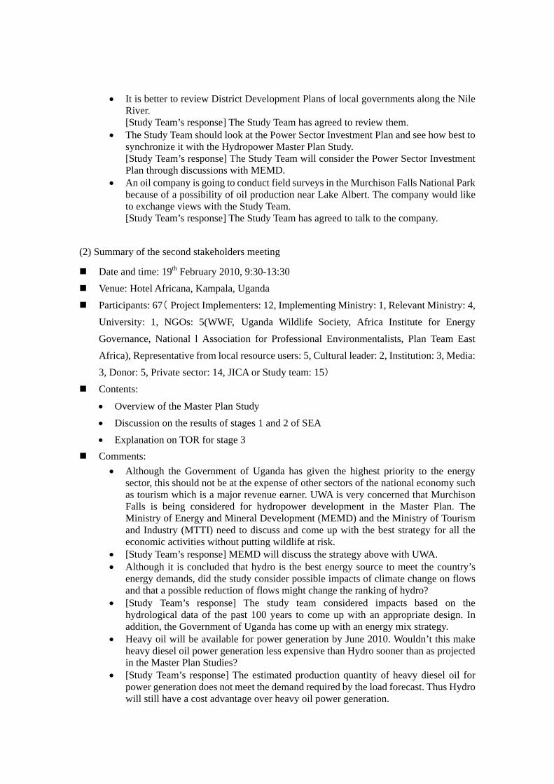
• It is better to review District Development Plans of local governments along the Nile River. [Study Team’s response] The Study Team has agreed to review them.
• The Study Team should look at the Power Sector Investment Plan and see how best to synchronize it with the Hydropower Master Plan Study. [Study Team’s response] The Study Team will consider the Power Sector Investment Plan through discussions with MEMD.
• An oil company is going to conduct field surveys in the Murchison Falls National Park because of a possibility of oil production near Lake Albert. The company would like to exchange views with the Study Team. [Study Team’s response] The Study Team has agreed to talk to the company.
(2) Summary of the second stakeholders meeting
Date and time: 19th February 2010, 9:30-13:30 Venue: Hotel Africana, Kampala, Uganda (Participants: 67 Project Implementers: 12, Implementing Ministry: 1, Relevant Ministry: 4,
University: 1, NGOs: 5(WWF, Uganda Wildlife Society, Africa Institute for Energy Governance, National l Association for Professional Environmentalists, Plan Team East Africa), Representative from local resource users: 5, Cultural leader: 2, Institution: 3, Media:
)3, Donor: 5, Private sector: 14, JICA or Study team: 15 Contents:
• Overview of the Master Plan Study • Discussion on the results of stages 1 and 2 of SEA • Explanation on TOR for stage 3
Comments: • Although the Government of Uganda has given the highest priority to the energy
sector, this should not be at the expense of other sectors of the national economy such as tourism which is a major revenue earner. UWA is very concerned that Murchison Falls is being considered for hydropower development in the Master Plan. The Ministry of Energy and Mineral Development (MEMD) and the Ministry of Tourism and Industry (MTTI) need to discuss and come up with the best strategy for all the economic activities without putting wildlife at risk.
• [Study Team’s response] MEMD will discuss the strategy above with UWA. • Although it is concluded that hydro is the best energy source to meet the country’s
energy demands, did the study consider possible impacts of climate change on flows and that a possible reduction of flows might change the ranking of hydro?
• [Study Team’s response] The study team considered impacts based on the hydrological data of the past 100 years to come up with an appropriate design. In addition, the Government of Uganda has come up with an energy mix strategy.
• Heavy oil will be available for power generation by June 2010. Wouldn’t this make heavy diesel oil power generation less expensive than Hydro sooner than as projected in the Master Plan Studies?
• [Study Team’s response] The estimated production quantity of heavy diesel oil for power generation does not meet the demand required by the load forecast. Thus Hydro will still have a cost advantage over heavy oil power generation.

• The Kalagala offset is a government obligation in return for the World Bank funding of the Bujagali Project. Does the inclusion of Kalagala in the Hydro Master Plan mean that the government has reneged on its obligation on the implementation of projects under the Kalagala Offset?
• [Study Team’s response] The government is still committed to implementing programs under the Kalagala Offset. That is why although Kalagala is ranked above Bujagali, no feasibility study (FS) is planned. However, when and if conditions change in the future, as FS may be considered.
• I am not satisfied that small hydro and wind energy were not considered in this study. Micro hydro power and wind power have a major impact on rural villages and communities.
• [Study Team’s response] Small hydro and wind power can indeed have an impact on rural communities. However, looking at the national demand forecast, several small hydro projects will be required to have a significant impact on the energy demand, while one large hydro project provides exactly the same impact required by the demand forecast.
• It is necessary to keep in mind that existing and completed dams are not working as they are supposed to.
• [Study Team’s response] Poor performance of existing dams cannot be used as a standard for all dams. Many aspects including design criteria vary among dams.
• There is a concern that the construction of a dam may cause deforestation. • [Study Team’s response] The projects are all run-off river type and if with small daily
poundage reservoirs, if any, that will not cause any inundation. On the other hand, the availability of electric power to a larger population is likely to reduce charcoal burning and relieve pressure on the forests.
• It seems that the weighting was done only from the environmental perspective. Did the weighting also consider monetary weights in terms of revenue lost from tourism?
• [Study Team’s response] Yes. • It was mentioned by the Permanent Secretary in his remarks that the study needs to be
taken through the Feasibility level up to design and Tendering. Who makes that decision?
• [Study Team’s response] MEMD • The Nile goes through many countries. Will there be a conflict of interest with
countries such as Egypt? • [Study Team’s response] This will be solved through political negotiations. • Regarding power import, the study should critically examine the potentials of
respective countries before recommending it. • [Study Team’s response] This will be considered. • An increase in population will also increase water usage and consequently reduce
yield of flows and power generation. Did the study consider such a scenario and an impact on downstream water uses?
• [Study Team’s response] Under hydrology, the study considers that minimum flows taken into consideration in determining design discharges will take care of such variations.
• The zoning of the Park as provided to the study team by UWA was done several years ago when there were no human activities in the park. This might have to be reconsidered in light of oil drilling activities taking place in the western part of the conservation area. UWA would want to rezone the park area to let animals move to areas with less human presence. So what was designated as a moderate tourist activity would become a zone of intense tourism.

• [Study Team’s response] This will need to be discussed with all stakeholders • Slide 13 of the presentation in the third session with pictures taken by the study team
after bush fires gave the wrong impression that the conservation area was clear and easy to access. The area is actually an impenetrable forest during most of the year.
• [Study Team’s response] The picture was indeed taken after a bush fire. However, the trees were not destroyed and the picture shows well the distribution of trees which is well confirmed by a satellite image.
11 Terms of Reference for Environmental and Social Considerations The survey areas, survey methods and survey periods are different among the three stages.
Table 11-1 Survey area, methods and period of each stage
Stage Alternatives Survey Area Survey Method Study
Period Stage 1 Possible energy source
Hydro, Geothermal, Diesel Engine (Heavy Oil), Wind Power, Biomass Thermal Cogeneration, Solar Thermal, Nuclear, Energy import
Uganda Literature Survey Dec. 2009 – Jan. 2010
Stage 2 Possible hydropower projects Kalagala, Isimba, Karuma, Oriang, Ayago, Kiba, Murchison
7 possible site
Literature Survey and Site reconnaissance
Jan. 2010 – Feb 2010
Stage 3 Possible layouts Layout 1, Layout 2, Layout 3 (not decided yet in the Ayago site)
Ayago site Boring survey, Biological Survey, Social survey
June 2010 – Dec. 2010
Stage 1 and 2 were finished, and then TOR of stage 3 was considered. Survey areas, survey methods might be changed by the recommendation from NEMA which will issue a certificate before the survey.
11.1 Description of the project In Ayago project, a run-off-river type hydropower plant is planned. Installed capacity is 616MW. Weir height is 10m. Water length is 8km. Powerhouse is underground type. The overall layout of Ayago project is shown in Figure 11-1. Brief design is shown in Figure 11-2.

Figure 11-1 Overall layout of the Ayago site

Figure 11-2 Brief Design of the Ayago site

11.2 Survey area in Stage 3 Geological investigation and topographic survey will be carried out at all structural sites of Ayago hydropower station including intake site, powerhouse, tunnel and outlet site as shown in Figure 11-3 andFigure 11-4. Biological survey and social survey area are planned to cover access roads and possible evacuate area of the animals in the project site as shown in Figure 11-5.
Figure 11-3 Location Map of Geological Investigation
Intake site 5 holes (left bank)
Outlet site
2 holes (left bank)
LEGEND
Drilling point (8 holes)
Camp site
Existing road
Access route
Ground mapping area (36 km2)
Distance from existing road - to intake site: 9 km - to outlet site: 12.5 km
0 4 km
N
Note: The quantities and its locations mentioned above are subject to revision in the course of the work depending on new findings.
Base map: 1:50,000 WANGKWAR Sheet 30/2

Figure 11-4 Topographic survey area
Figure 11-5 Biological and Social Survey Areas
4 km 0
1:10,000 mapping area (100 km2)1:1,000 mapping area (3 km2) River cross section survey (18
ti )
LEGEND
N
Note: The quantities and its locations mentioned above are subject to revision in the course of the work depending
Base map: 1:50,000 WANGKWAR Sheet 30/2

11.3 Survey Method 11.3.1 Geological Investigation
11.3.1.1 Core drilling with testing Transportation of Boring machine
Eight drill holes in the two locations (planned intake and outlet site) of Ayago site are scheduled. The distances to the two boring sites from the existing road are approximately 9 km and 12.5 km respectively. The boring equipments, approximately 1.5 m-2 m wide and 3 m-5 m long, will be transported to the site in tow. Most of proposed access route is set in grassland or open forests. Relatively dense forests occur only along the Nile River. Therefore, bush cutting will be required in some locations, however, neither cutting of big trees nor road construction.
Core drilling
Core drilling survey will performed for obtaining soil/rock core samples from under the ground to study geological condition of the Ayago site. The diameter of the boreholes is approximately 60~80 mm. Approximately 10~20 L/min of water is necessary for drilling and approximately 50 L/min of water for water pressure test. Most of used water generally infiltrates ground in borehole. Some returned water will be induced a setting pond for siltation before released to the river. After the completion of the drilling work, the surveyor shall remove all equipment/materials and garbage from the drilling points. PVC screen pines will be install boreholes for long-term assessment of groundwater.
11.3.1.2 Ground mapping Surface geological condition will be surveyed and recorded through the observation of outcrops of bedrocks. The survey area is shown in Figure 11-3. Bush cutting shall be minimized during the survey and no machinery will be used for ground mapping.
11.3.1.3 Installation of staff gauges and water level monitoring A couple of stuff gauge shall be installed on the river bank of the Nile River (See Figure 11-6). Water level of the Nile River shall be measured and recorded by reading the staff gauges.

Figure 11-6 Structural Image of staff gauge
11.3.2 Topographic Survey
11.3.2.1 Installation of new bench marks and control points Seven concrete bench marks (approximately 30 cm x 30 cm) and 20 control points (approximately 100 cm x 100 cm wooden board with pegs) will be installed for the benchmarks and control points for aerial photography. Bench marks will be installed at intake site, outlet site and along tunnel alignment. Control points will be scattered in the aerial photography area. Exact locations of these markers will be determined through the consideration of the field condition. Bush cutting shall be minimized during the survey and no machinery will be used for this installation work in principle.
11.3.2.2 Aerial photography Aerial photographs will be taken by use of an airplane for the photogrammetric mapping areas at 1:10,000 and 1:1,000. The areas to be covered by the aerial photography are shown in Figure 11-4.
11.3.2.3 River cross section survey of Nile River River cross section survey will be done at 18 locations shown in Figure 11-4. Bush cutting shall be minimized during the survey and no machinery will be used in principle. 11.3.3 Biological Literature Survey
Literature Survey includes information collection, acquisition of satellite image, and analysis of

information.
11.3.3.1 Information collection Literature survey aims to collect information on the areas such as the survey data by Uganda Wildlife Authority (UWA), the Oil Company2 and biologists / social scientists who have conducted field surveys in and around the areas. The information includes no only the survey data by UWA, but also monitoring of existing projects by related organizations. Interview survey to these staff and experts shall be conducted.
11.3.3.2 Acquisition of satellite image Literature Survey includes acquiring satellite image of survey area B, resolution is 0.5-1m, and image type is orthorectified imagery.
11.3.3.3 Analysis of Information For bird survey, the study team select important species especially IUCN red-listed species and their habitat types in the survey area A based on the literature survey. 11.3.4 Biological Survey
The biological survey obtains biological baseline data for the Work. The targets of the biological survey include large and medium mammals, birds, reptiles and amphibians, fishes, insects, and flora and vegetation. Detail survey routes, survey points, and survey sheets have not been decided yet.
11.3.4.1 Large and Medium Mammals The main purpose of this “Large and Medium Mammals” survey is to identify critical areas for these animals especially Giraffe Giraffa camelopardalis, Common Hippopotamus Hippopotamus amphibious, African Elephant Loxodonta africana, Lion Panthera leo and Leopard Panthera pardus. Survey method is as follows. Table 11-2 Method and outputs of mammal survey
Name Survey
Area
Survey
time
Survey
Method
Outputs
Basic
Survey
Survey
Area A
6:00
-18:00
Route
census
• Recorded survey sheets; • GPS log file; • Species list (name and numbers of each species);
2 Tullow Oil plc etc. has already conducted an EIA study for the test drilling.

• Distribution map (mesh of 8 km x 8 km suggested in Figure 2)3: The map of the founded mammals in Table 4. The distribution maps shall contain rough numbers of the species, their home ranges, migration routes, feeding grounds, and resting areas.
Detailed
Survey
Survey
Area B
6:00
-18:00
Route
census
• Recorded survey sheets; • GPS log file; • Species list (name and numbers of each species); • Distribution map (2 km mesh)4: The map of the founded
mammals in Table 4. The distribution maps shall contain rough numbers of the species, their home ranges, migration routes, feeding grounds, and resting areas.
11.3.4.2 Birds The main purpose of the “Bird” survey is to identify critical areas/habitats for birds. Structures including dam, access roads and buildings should not be located in or across a part of these critical areas/ habitats. Survey method is as follows. Table 11-3 Method and output of bird survey
Name Survey
Area
Survey time Survey Method Outputs
Basic
Survey
Survey
Area A
6:00 to 10:00
17:00 to 19:00
Route census
(Walking speed
is 4 km/hour).
• Recorded survey sheets; • GPS log file; • Species list (inventory list of
numbers of each species); • Important habitat map 5 (8 km
mesh) Detailed
Survey
Survey
Area B
6:00 to 10:00
17:00 to 19:00
Route census
(Walking speed
is 4 km/hour).
• Recorded survey sheets; • GPS log file; • Species List (inventory list of
numbers of each species); • Important habitat map (2 km
mesh) • Regarding large raptors (eg. Gyps
spp.), their nesting trees should be located if any.
• If any breeding behaviours are observed, species and their locations must be recorded.
3 “8 km mesh distribution map” means at least one observation point (or census line) must be set up in the one mesh of Area A. 4 “2 km mesh distribution map” means at least one observation point (or census line) must be set up in the one mesh of Area B. 5 Habitat map means a map which shows important area for birds such as breeding, feeding, and resting areas.

11.3.4.3 Reptiles and amphibians The main purpose of this “Reptiles and amphibians” survey is to identify critical areas for these animals especially Nile crocodile Crocodylus niloticus. Survey method is as follows.
Table 11-4 Method and output of reptile and amphibian survey
Name Survey
Area
Survey time Survey Method Outputs
Basic
Survey
Survey
Area A
6:00 to 17:00
19:00 to 21:00
Line census (Walking
speed is 4 km/hour).
• Recorded survey sheets; • GPS log file; • Species list (inventory list of
numbers of each species); • Important habitat map (8 km
mesh) Detailed
Survey
Survey
Area B
6:00 to 17:00
19:00 to 21:00
Line census (Walking
speed is 4 km/hour).
• Recorded survey sheets; • GPS log file; • Species list (inventory list of
numbers of each species); • Important habitat map (2 km
mesh)
11.3.4.4 Fishes The survey method of fishes is collection by cast net and gill net. Survey points are 7 points in Basic Survey area.
Table 11-5 Method and output of fish survey
Name Survey
Points
Survey time Survey Method Outputs
Basic
Survey
7 points 6:00 to 17:00 Collection by cast net
and gill net
• Recorded survey sheets; • GPS log file; • Species list (inventory list
of numbers of each species);
11.3.4.5 Insects (Rhopalocera) The survey method of insects is line census of 4 km in detailed survey area 8km in basic survey area and collecting butterfly. Survey areas are Survey Area A and B. Survey methods are sweeping.
Table 11-6 Method and output of insect survey
Name Survey
Area
Survey time Survey Method Outputs
Basic
Survey
Survey
Area A
6:00 to 17:00 Route census (Walking
speed is 4 km/hour).
• Recorded survey sheets; • GPS log file; • Species list (inventory list
of numbers of each species);
• Important habitat map (8 km mesh)
Detailed
Survey
Survey
Area B
6:00 to 17:00 Route census (Walking
speed is 4 km/hour).
• Recorded survey sheets; • GPS log file; • Species list (inventory list
of numbers of each species);
• Important habitat map (2 km mesh)
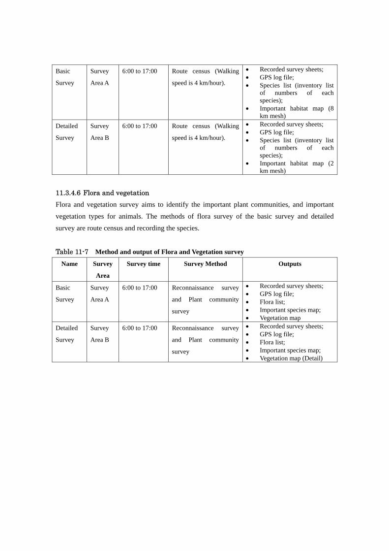
11.3.4.6 Flora and vegetation Flora and vegetation survey aims to identify the important plant communities, and important vegetation types for animals. The methods of flora survey of the basic survey and detailed survey are route census and recording the species.
Table 11-7 Method and output of Flora and Vegetation survey
Name Survey
Area
Survey time Survey Method Outputs
Basic
Survey
Survey
Area A
6:00 to 17:00 Reconnaissance survey
and Plant community
survey
• Recorded survey sheets; • GPS log file; • Flora list; • Important species map; • Vegetation map
Detailed
Survey
Survey
Area B
6:00 to 17:00 Reconnaissance survey
and Plant community
survey
• Recorded survey sheets; • GPS log file; • Flora list; • Important species map; • Vegetation map (Detail)

11.3.5 Social survey
The social survey aims to grasp the overall baseline socio-economic information in and around the project area. Development in an area will normally cause positive or negative impacts on the social and economic status of communities directly affected by such development. During the pre-feasibility study, a baseline will be established against which changes should ideally be measured before, during development and future operations of the Ayago Hydropower project.
11.3.5.1 Land use The survey methods of land use are analyzing satellite or aerial photos and conducting a site survey. The land types such as forest, woodland, grassland, bush land, wetland, farmland and residential area are to be identified. A land use map will be made. In addition, any other data and information on land use should be collected from UWA, District Land Board, District Secretary / Department for Production and Natural Resources, UNHCR and local residents.
11.3.5.2 Buildings and houses The survey methods of buildings and houses are analyzing satellite or aerial photos and conducting a site survey. The number and type of affected buildings and houses will be identified. Building and housing maps will be made. Other data and information on affected buildings and houses can also be collected from UWA, District Planning Office, UNHCR and local residents.
11.3.5.3 Roads The survey methods of roads are analyzing satellite or aerial photos and conducting a site survey. The types, location and utilization of roads (including traffic volume) are identified. If possible, the occurrence of road kill would be surveyed. Current roads maps and a future roads plan map will be made. Other data and information can be collected from UWA, District Secretary / Department for Works and Technical Services and local residents.
11.3.5.4 Regional economy The survey methods of regional economy are interviews and statistical data analysis. The types and sales of economic activities including agriculture, fishery, forestry, manufacturing and services will be found. Also, the number of workers for each activity will be estimated. Interview can be done with District Secretary / Department for Production and Natural Resources and local residents.
11.3.5.5 Hunting and collecting The survey method of hunting and collecting is interviews. The targets, locations and purposes of

hunting and collecting will be identified. A hunting and collecting map will be made. In addition, data and information on hunting and collecting will be collected from UWA, District Secretary / Department for Production and Natural Resources and local residents6.
11.3.5.6 Places of Cultural interest The survey methods of places of cultural interest7 are interviews and site survey. The types, locations and utilizations of the places will be identified. A cultural site map will be made. Information can be collected from traditional or cultural leaders and local residents.
11.3.5.7 Tourism The survey methods of tourism survey are data analysis and interviews. The types, locations and sales of tourism activities are identified. Data and information will be collected from UWA, and private tour companies working in the park.
11.3.5.8 Water use The survey method of water use is interview. The types, locations and utilization of water by local residents will be identified. Interview can be done with the District Water office and the Directorate for Water Development and local residents.
11.4 Work schedule of Stage 3 Survey schedules of Ayago site are shown in Table 11-8 toTable 11-10.
6 There may be Memorandum of Understandings in some cases allowing hunting and collecting activities, signed between UWA and the local community 7 Places of cultural interest deals with physical resources which can be defined as movable or immovable objects, sites, structures, groups of structures, and natural features and landscapes that have archaeological, palaeontological, historical, architectural, religious, aesthetic, or other cultural significance.

Table 11-8 Schedule of Geological Investigation No. Investigation Items
Unit QuantityI Geological Investigation
1 Ground mapping km2 36
2 Aerial photo interpretation km2 100
3 Core drillingIntake m 100Powerstation m 200 31 AugOutlet m 50total m 350
4 Laboratory test LS 1 30 Sep
5 Construction material survey LS 1
6 Installation of staff gauge location 2
7 Water level monitoring month 2
8 Reporting LS 117 Sep Draft reort of Drill survey
15 Oct Final report
2010Apr May Jun Jul Aug Sep Oct Nov Dec
Table 11-9 Schedule of Topological Survey
Unit Quantity
1 Ground control survey LS 1
2 Installtion of control points LS 1
3 Aerial photography km2 100
4 Photogrammetric mapping km2 100 S=1:10,0001:10,000 and 1:1,000 km2 3 S=1:1,000
5 River cross section survey sections 18Oct 15 Final report
6 Drawing/reporting LS 1
Note:The schedule of aerial photography is subject to weather condition of the site.
Survey ItemsNo.2010
May Jun Jul Aug Sep Oct
Table 11-10 Schedule of Biological and Social Survey
Quontitty UnitBiological Survey
1. Preparation2. Site Survey
Sparse survey 661 km2 Detail survey 82 km2
3. Data arranegment4. Report Preparation
Social Survey1. Preparation2. Site Survey
Sparse survey 661 km23. Data arranegment4. Report Preparation
Sep OctMay Jun Jul Aug
12 Other relevant information
The study on Stage 1 and 2 has been finished by the end of February 2010. Multi Criteria

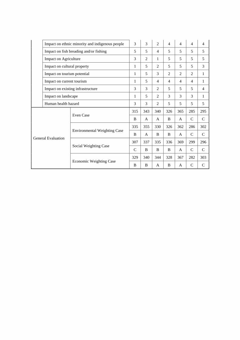
decision analysis was used for the comparative evaluation. The result of stage 1 suggested Hydro would be the most suitable energy source to fulfill the demand until 2023. The result of stage 2 suggested that Ayago is the best project for JICA to forward pre-feasibility study on stage 3 of this master plan study.
Table 12-1 General Evaluation of Various Energy Sources on Stage 1
Evaluation items Weight
Hyd
ro
Geo
ther
mal
Die
sel E
ngin
e (H
eavy
Oil)
Win
d Po
wer
B
iom
ass
The
rmal
C
ogen
erat
ion
Sola
r T
herm
al
Nuc
lear
+
Ene
rgy
impo
rt
Econ
omic
and
tech
nica
l
Cost**
Development cost(USD/kW)
34
12
4 3 3 5 1 1 1 1 5
Operation & Maintenance cost (USD/kW/year) 4 5 3 3 5 3 5 1 5
Unit cost of power generation (USD/MWh) 4 5 5 1 5 3 1 5 1
Development potential**
Existing potential (MW)
12
4 5 3 3 1 4 2 4 2 Technically feasible potential at present (MW) 4 5 3 2 1 4 3 1 1
Availability of Energy Source+ 4 4 5 2 1 2 3 1 1
Construction* Survey maturity
53 4 3 5 1 5 5 1 1
Lead time for construction 2 3 2 5 1 4 4 1 3
Operation
Initial Starting Time
4
1 5 3 4 1 3 3 2 1 Energy stability 1 4 5 5 1 3 1 5 3 Power supply stability 1 4 5 3 1 2 1 2 2 Life Span (Year) 1 5 4 3 4 4 4 4 5
Contribution to national economy* 1 1 5 5 1 3 5 3 5 3
Envi
ronm
enta
l
Air pollution
33
4 5 5 1 4 2 4 5 2 Water pollution 5 3 2 3 5 3 4 2 2 Consumption of natural resource* 5 5 4 1 5 3 5 3 1 CO2 emission 4 5 4 1 3 3 2 5 1 Waste 4 4 3 3 5 2 5 1 2 Water right/ water resource* 5 2 4 3 5 4 4 3 3 Impact on natural ecology** 6 1 3 2 4 3 5 3 2
Soci
al
Impact on Agriculture
33
5 2 5 5 3 1 4 5 5 Resettlement 5 2 5 5 3 1 5 4 5 Impact on fishery 6 1 3 2 5 2 5 2 2 Impact on tourism 5 1 4 5 2 5 3 3 5 Legal aspects 4 5 3 5 5 5 1 5 5 Human health hazard+ 4 2 2 2 4 2 5 2 2 Risk of accident 4 2 4 1 5 4 5 2 1
General Evaluation Even Case 328 363 291 344 295 368 285 264B A C B C A C C

Environment weighting case 320 367 277 367 291 378 298 261B A C A C A C C
Economic Weighting Case 367 361 299 266 332 348 260 219A A C C B B C C
Table 12-2 General Evaluation of Potential Hydropower Projects in Stage 2
Evaluation items
Kal
agal
a
Isim
ba
Kar
uma
Ori
ang
Aya
go
Kib
a
Mur
chis
on
Econ
omic
and
tech
nica
l
Cost** Construction Cost (MUS$) 5 5 3 3 3 2 4
Generation Cost (cent/kWh) 5 2 4 3 5 1 4
Effectiveness*
Maximum Power (MW) 3 1 4 3 5 2 5
Construction time (year) 5 5 4 4 4 4 5
Head (m) 1 1 4 3 5 2 5
Distance to load center or existing
grid(km) 4 2 5 3 2 2 1
Length of Waterway 5 5 2 2 3 1 4
Geological Condition 4 4 3 3 3 3 3
Excavation Volume 4 5 2 3 3 1 4
Construction material
(availability) 5 5 4 4 4 3 5
Accessibility 5 5 5 4 3 2 4
Loss of transmission 5 5 5 4 5 4 4
Development
progress
Lead Time 2 2 5 3 4 3 3
Financial Negotiation and close 1 3 3 3 3 3 1
Envi
ronm
ent
Length of water recession (km) 5 5 2 2 3 1 4
Rate of recession (%) 5 5 2 2 2 2 2
Impact on Protected area* 3 3 4 2 2 2 1
Impact on wetland* 5 5 3 5 5 5 5
Impact on protected species* 5 5 2 2 2 2 1
Degradation of underground water 5 5 2 2 3 1 5
CO2 emission from the reservoir 2 1 5 5 5 5 3
Soci
al Land acquisition 1 1 5 4 4 4 2
Flooding area* 2 1 5 5 5 5 3
Number of affected people 2 1 2 5 5 5 5
Impact on ethnic minority and indigenous people 3 3 2 4 4 4 4
Impact on fish breading and/or fishing 5 5 4 5 5 5 5
Impact on Agriculture 3 2 1 5 5 5 5
Impact on cultural property 1 5 2 5 5 5 3
Impact on tourism potential 1 5 3 2 2 2 1
Impact on current tourism 1 5 4 4 4 4 1
Impact on existing infrastructure 3 3 2 5 5 5 4
Impact on landscape 1 5 2 3 3 3 1
Human health hazard 3 3 2 5 5 5 5
General Evaluation
Even Case 315 343 340 326 365 285 295
B A A B A C C
Environmental Weighting Case 335 355 330 326 362 286 302
B A B B A C C
Social Weighting Case 307 337 335 336 369 299 296
C B B B A C C
Economic Weighting Case 329 340 344 328 367 282 303
B B A B A C C